spatial analysis of large atmospheric oscillations and ... · b. vaheddoost124 very different...
TRANSCRIPT

European Water 59: 123-129, 2017. © 2017 E.W. Publications
Spatial analysis of large atmospheric oscillations and annual precipitation in lake Urmia basin
B. Vaheddoost Department of Civil Engineering, Istanbul Technical University, Turkey e-mail: [email protected]
Abstract: Precipitation is the main phenomenon that brings water from the surface of the oceans to the land surface all around the world. Oscillation of large atmospheric patterns, happening in oceans however is proved to have a great effect on the pattern of precipitation based on spatiotemporal and geographical properties of the region. Lake Urmia, as a wetland of international importance and the world’s second largest hyper-saline lake is dealing with water shortage basin wide. Due to importance of studying behaviour of major role players in the basin, effect of several well-known large atmospheric oscillations namely, North Atlantic Oscillation (NAO), El Nino/Southern Oscillation (ENSO), Atlantic Multidecadal Oscillation (AMO), Arctic Oscillation (AO), Indian Ocean Dipole (IOD), Southern Annular Mode (SAM) and Pacific Decadal Oscillation (PDO) were investigated by means of zero-lagged cross-correlation projected on heat maps on the basin. Considering 95% confidence limit in the analysis, it is observed that the PDO, ENSO, IOD and SAM oscillations have significant correlations with annual precipitation. In addition, harmonic means of annual precipitation, Euclidian distance and mutual information coefficient were used in comparison with cross-correlation patterns in order to define the most effective oscillations. It is concluded that ENSO oscillation pattern has the most similar pattern with harmonic mean of annual precipitation while the PDO has the major effect across the basin.
Key words: Lake Urmia, large atmospheric oscillation, precipitation, spatial analysis
1. INTRODUCTION
Lake Urmia is one of the most important hyper-saline lakes in the world and a terminal lake for migrant birds. Precipitation as the cornerstone of lake hydrological cycle is being fed by water evaporated from large bodies of water around the world. Large atmospheric oscillations are periodic or quasi-periodic cycles associated with climate patterns like atmospheric temperature, sea surface temperature, precipitation etc. which usually change as inter-annual and/or multi-annual patterns. The most well-known oscillations are North Atlantic Oscillation (NAO), El Niño/Southern Oscillation (ENSO), Atlantic Multidecadal Oscillation (AMO), Arctic Oscillation (AO), Indian Ocean Dipole (IOD), Southern Annular Mode (SAM) and Pacific Decadal Oscillation (PDO).
NAO is a weather phenomenon happening in North Atlantic Ocean causing changes in atmospheric pressure at sea level between the Icelandic low and the Azores high. El Niño is happening due to warming water surface in the eastern tropical Pacific Ocean by the sun. Together with La Niña, it pushes the limits of two out of three states of the constantly changing ENSO oscillation that can affect weather patterns around the globe. AMO is also a climate oscillation which is effective on the sea surface temperature in North Atlantic Ocean. AO or also called Northern Annular Mode/Northern Hemisphere Annular Mode (NAM) is an index of the non-seasonal sea-level pressure variating in the north of the 20º northing latitude. IOD, also known as the Indian Niño, is an irregular pattern of oscillation in the sea-surface temperatures in which the western Indian Ocean becomes alternately warmer and then colder than the eastern part of the ocean. SAM oscillation, also known as Antarctic oscillation (AAO) or Southern Hemisphere Annular Mode (SHAM) is a low-frequency mode of atmospheric variability of the southern hemisphere. PDO, is a long-lived oscillation very similar to the El Niño pattern in Pacific climate variability, while the two climate oscillations have similar spatial climate fingerprints, they have

B. Vaheddoost 124
very different temporal behaviour. There are several studies about the effect of these oscillations on precipitation, in which
Marchane et al. (2016) and Pavia et al. (2016) are among those who investigated the effect of large atmospheric oscillations on precipitation recently. The structure and characteristics of annual precipitation in Lake Urmia basin was detailed by Vaheddoost and Aksoy (2017); also Alipour (2006), Hassanzadeh et al. (2012), Delju et al. (2013), Tabari et al. (2013), Ghajarnia et al. (2015), Alizadeh‐Choobari et al. (2016), Fathian et al. (2016) and Fazel et al. (2017) studied precipitation characteristics in Lake Urmia Basin. However, the effect of large atmospheric oscillations in Lake Urmia basin was not studied in details. Although the effect of these oscillations on annual precipitation around the world is too coarse to be detailed at annual time interval, a multi-annual analysis can also reveal the effect of major role players within the basin. In this study, precipitation data recorded in 53 meteorological stations across the basin from 1981 to 2011 are used. Time series of 31 years of recorded data are compared with annual time series of NAO, ENSO, AMO, AO, IOD, SAM and PDO oscillations.
2. DATA
Data used in this study are total annual precipitation of 53 stations sharing 31 years of common record length from 1981 to 2011. A comparison over similarities between total annual precipitation characteristics and major atmospheric oscillations is aimed in this study. As Vaheddoost and Aksoy (2017) concluded, Box and Whiskers plots of selected stations show existence of outliers within the data which cause in positive asymmetry over distributions (Figure 1).
Figure 1. Box and Whiskers plot of annual precipitation in stations over Lake Urmia basin.
Time series of the stations were compared with the annual time series of selected oscillations provided from National Oceanic and Atmospheric Administration of United States (NOAA, 2015). Zero-lag cross-correlation between annual precipitation over the basin crossed with oscillation time series in which ENSO, SAM, IOD and PDO showed significant linear correlation with precipitation. This significance boundary was considered based on 95% confidence limit over 31 years as ±0.35 to define the degree of significance in analysis.
Most of the oscillations are effective in western and south-western parts of the basin. It is found that NAO, has no major effect on the basin, while there are a few hot spots with insignificant positive cross-correlation in south-west, west and east of the lake. The same analysis can be associated with AO and AMO oscillations which have positive effect mostly on south-west, south and east of the lake. PDO however, has a major and significant effect on precipitation in west, centre and south parts of the basin. On the other hand, analysis for IOD and SAM shows more effective and positively correlated precipitation in eastern side of the basin.
European Water 59 (2017) 125
3. METHODS USED
To define and track the degree of similarity and concordance between each pair of station-oscillation time series, several methods are used. Harmonic mean of annual precipitation in each station is used to reduce the effect of interdependence in time and space over time series. Harmonic mean tends toward the least elements of the data set (i.e. compared to the arithmetic mean) to mitigate the impact of large outliers and aggravate the impact of small ones. The degree of graphical concurrency is measured by the match of hotspots over heat map and iso-height map. Considering time series analysis, the most common metric is the Euclidean distance which measures the length of a vector between x and y as
( )2xy t ttD x y= −
(1)
where ǀDxyǀt is the distance between time series X and Y at time t. Analysis between harmonic mean of precipitation and oscillation time series are both standardized, to be used as a measure of comparison. Results of this comparison are shown on heat maps over basin, while stations with lower Euclidean distance shows more similarities with the atmospheric oscillations. Mutual information coefficient (MIC) is also used to determine the amount of information attainable within the data. Mutual information contains information about all linear and nonlinear dependence in time.
There are sophisticated methods of calculating mutual information coefficient while a simple one is suggested by Gel'fand and Yaglom (1957) as
( )2,log 1
2xy trMIC
− −=
(2)
where rxy,t is the cross-correlation coefficient between annual precipitation and atmospheric oscillation. Results of this analysis are also shown on heat map over basin.
4. RESULTS AND DISCUSSION
4.1 ENSO
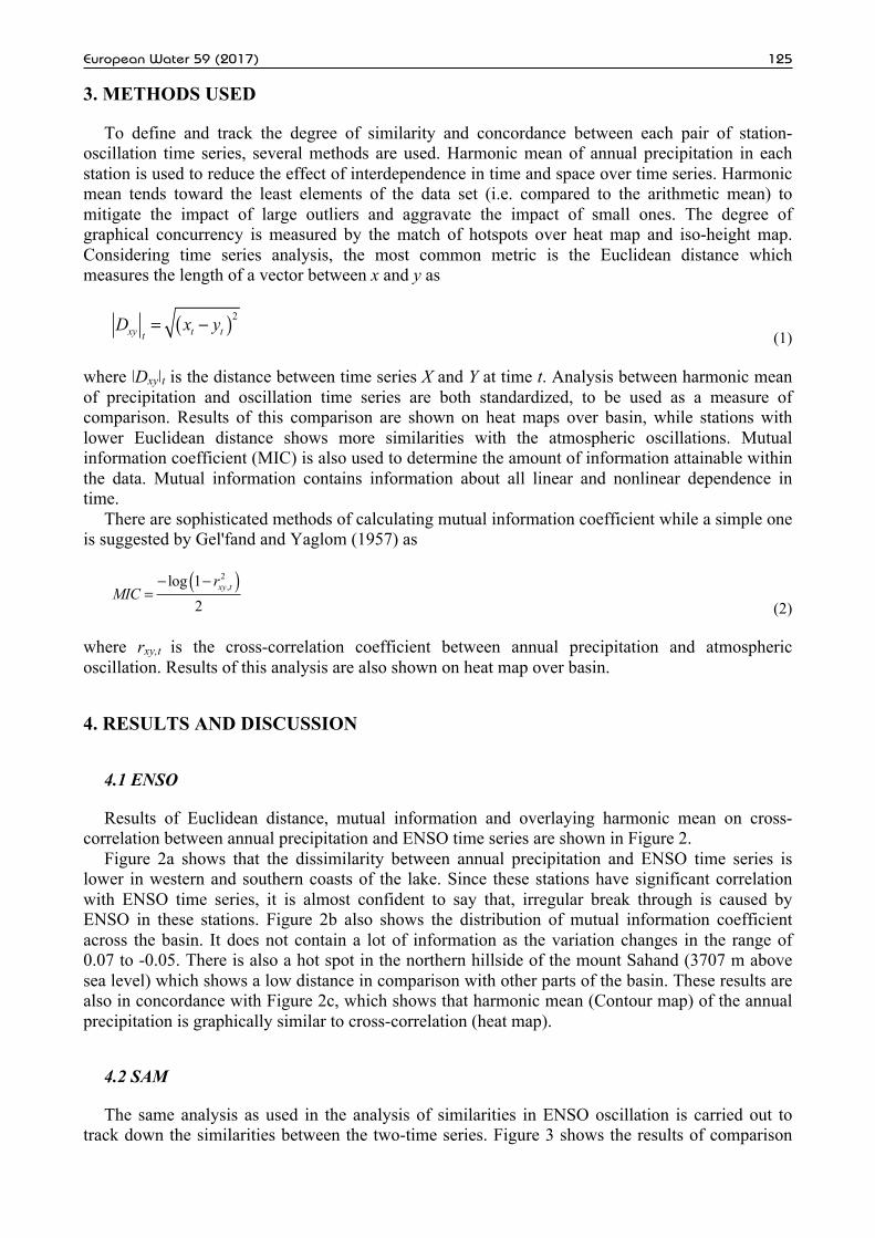
Results of Euclidean distance, mutual information and overlaying harmonic mean on cross-correlation between annual precipitation and ENSO time series are shown in Figure 2.
Figure 2a shows that the dissimilarity between annual precipitation and ENSO time series is lower in western and southern coasts of the lake. Since these stations have significant correlation with ENSO time series, it is almost confident to say that, irregular break through is caused by ENSO in these stations. Figure 2b also shows the distribution of mutual information coefficient across the basin. It does not contain a lot of information as the variation changes in the range of 0.07 to -0.05. There is also a hot spot in the northern hillside of the mount Sahand (3707 m above sea level) which shows a low distance in comparison with other parts of the basin. These results are also in concordance with Figure 2c, which shows that harmonic mean (Contour map) of the annual precipitation is graphically similar to cross-correlation (heat map).
4.2 SAM
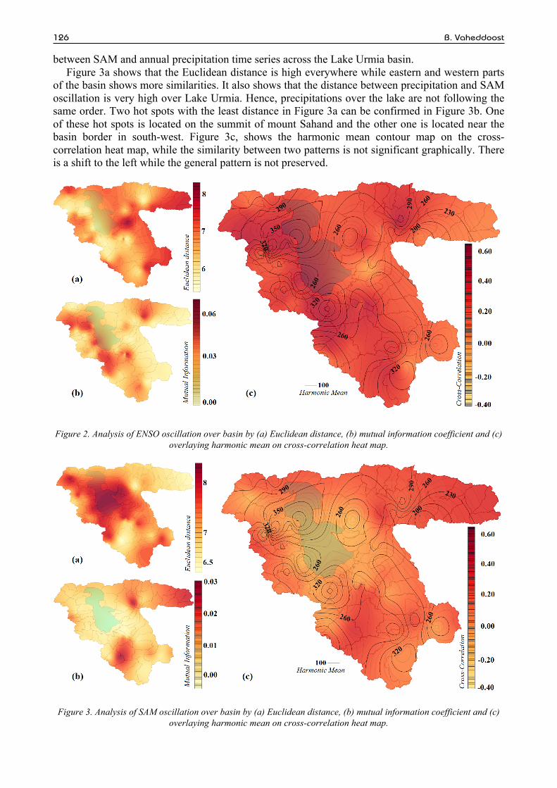
The same analysis as used in the analysis of similarities in ENSO oscillation is carried out to track down the similarities between the two-time series. Figure 3 shows the results of comparison
B. Vaheddoost 126
between SAM and annual precipitation time series across the Lake Urmia basin. Figure 3a shows that the Euclidean distance is high everywhere while eastern and western parts
of the basin shows more similarities. It also shows that the distance between precipitation and SAM oscillation is very high over Lake Urmia. Hence, precipitations over the lake are not following the same order. Two hot spots with the least distance in Figure 3a can be confirmed in Figure 3b. One of these hot spots is located on the summit of mount Sahand and the other one is located near the basin border in south-west. Figure 3c, shows the harmonic mean contour map on the cross-correlation heat map, while the similarity between two patterns is not significant graphically. There is a shift to the left while the general pattern is not preserved.
Figure 2. Analysis of ENSO oscillation over basin by (a) Euclidean distance, (b) mutual information coefficient and (c) overlaying harmonic mean on cross-correlation heat map.
Figure 3. Analysis of SAM oscillation over basin by (a) Euclidean distance, (b) mutual information coefficient and (c) overlaying harmonic mean on cross-correlation heat map.

European Water 59 (2017) 127
4.3 IOD
The same analysis as used for ENSO and SAM oscillation comparatively is used for tracking the patterns of similarities (Figure 4).
Figure 4a shows that the similarities between annual precipitation and IOD time series is higher in eastern and southern parts of the basin. Mutual information however, shows that summit of mount Sahand is also affected by IOD oscillation (Figure 4b). It should be underlined that the hot spot associated with the southern part of the basin in mutual information is shifted to the north according to Euclidean distance map (Figure 4a) or contain similarities with much more distant length (similarities). Hence, eastern parts of the basin contain more information interconnected with IOD oscillation. Figure 4c, also shows that IOD oscillation has similarities with harmonic mean of the annual precipitation.
4.4 PDO
Figure 5, shows that the harmonic mean and PDO oscillation have a perfect graphical match while almost all of the hotspots are crossed over cross-correlation patterns. In addition, it is obvious that the PDO oscillation is effective mostly in western and southern parts of the Lake Urmia basin.
Euclidean distance shows that the highest similarities can be tracked in the western side of the basin (Figure 5a). There are also a few similarities in northern, western and southern hillside of the mount Sahand. Figure 5b shows that the disturbed pattern of annual precipitation in north-west, south-west and south of the basin. It demonstrates that the uncertainty associated with annual precipitation in western and southern parts of the basin can be related to the PDO oscillation. Figure 5c, however, shows more hotspots in western parts of the basin.
Figure 4. Analysis of IOD oscillation over basin by (a) Euclidean distance, (b) mutual information coefficient and (c) overlaying harmonic mean on cross-correlation heat map.

B. Vaheddoost 128
Figure 5. Analysis of PDO oscillation over basin by (a) Euclidean distance, (b) mutual information coefficient and (c) overlaying harmonic mean on cross-correlation heat map.
5. CONCLUSION
Similarities between annual precipitation and large atmospheric patterns of NAO, ENSO, AMO, AO, SAM, IOD and PDO are studied using cross-correlation, Euclidean distance and mutual information coefficient. Results of these analysis are expressed using heat map and contour map over Lake Urmia basin. It is concluded that ENSO, SAM, IOD and PDO have the most effect at annual scale on the precipitation over the basin. Results indicate that the harmonic mean has the most graphical similarities with cross-correlation of annual precipitation and PDO oscillation. It is also obvious that Euclidean distance and mutual information express more information in comparison with other similarity metrics such as Pearson correlation coefficient. Therefore, IOD and SAM oscillations in the eastern and ENSO and PDO oscillations in western and southern parts of the basin are effective.
REFERENCES
Alipour, S. (2006). Hydrogeochemistry of seasonal variation of Urmia Salt Lake, Iran. Saline systems 2(1): 1. doi: 10.1186/1746-1448-2-9.
Alizadeh-Choobari, O., Ahmadi-Givi, F., Mirzaei, N., Owlad, E. (2016). Climate change and anthropogenic impacts on the rapid shrinkage of Lake Urmia. International Journal of Climatology 36: 4276–4286.
Delju, A. H., Ceylan, A., Piguet, E., Rebetez, M. (2013). Observed climate variability and change in Urmia Lake Basin, Iran. Theoretical and applied climatology 111(1-2): 285-296.
Fathian, F., Aliyari, H., Kahya, E., Dehghan, Z. (2016). Temporal trends in precipitation using spatial techniques in GIS over Urmia Lake Basin, Iran. International Journal of Hydrology Science and Technology 6(1): 62-81.
Fazel, N., Berndtsson, R., Uvo, C. B., Madani, K., Kløve, B. (2017). Regionalization of precipitation characteristics in Iran’s Lake Urmia basin. Theoretical and Applied Climatology, 1-11. doi: 10.1007/s00704-017-2090-0
Gel'fand, I.M., Yaglom, A.M. (1957). Calculation of amount of information about a random function contained in another such function. American Mathematical Society Translations: Series 2. 12: 199–246. English translation of original in Uspekhi Matematicheskikh Nauk 2 (1): 3-52.
Ghajarnia, N., Liaghat, A., and Arasteh, P. D. (2015). Comparison and evaluation of high resolution precipitation estimation products in Urmia Basin-Iran. Atmospheric Research 158: 50-65.
Hassanzadeh, E., Zarghami, M., and Hassanzadeh, Y. (2012). Determining the main factors in declining the Urmia Lake level by using system dynamics modeling. Water Resources Management 26(1): 129-14.

European Water 59 (2017) 129
Marchane, A., Jarlan, L., Boudhar, A., Tramblay, Y., Hanich, L. (2016). Linkages between snow cover, temperature and rainfall and the North Atlantic Oscillation over Morocco. Climate Research 69(3): 229-238.
National Oceanic and Atmospheric Administration (NOAA). (2015). Climate Indices: Monthly Atmospheric and Ocean Time Series. http://www.esrl.noaa.gov/psd/data/climateindices/list/ (accessed 15 June 2015).
Pavia, E. G., Graef, F., Fuentes-Franco, R. (2016). Recent ENSO–PDO precipitation relationships in the Mediterranean California border region. Atmospheric Science Letters 17(4): 280-285.
Tabari, H., Nikbakht, J., Talaee, P. H. (2013). Hydrological drought assessment in North-western Iran based on streamflow drought index (SDI). Water resources management 27(1): 137-151.
Vaheddoost, B., Aksoy, H. (2017). Structural characteristics of annual precipitation in Lake Urmia basin. Theoretical and Applied Climatology 128(3-4): 919–932.