spatial data management i - university of northern british...
TRANSCRIPT

2017-09-25
1
Spatial Data Management I
GEOG 300, Lecture 6
Dr. Anthony Jjumba
1
Data Sources and Input Historic datasets and maps
Modern collection methods

2017-09-25
2
The Good Old Days
The Bad Old Days Digitizing centuries of hand-drawn maps…
Guess who got to do this job??
Prisoners
GIS Techs
Students!
Tedious and painstaking

2017-09-25
3
Digitizing
Digitizing is done in two ways:a. Tracing lines on maps initially using a tablet with map taped down, or
onscreen / ‘heads-up’ (= copying a map) – > 1995
Digitizing Procedure Lines = connected points
Manual point selection
Timed point selection
Interval point selection
http://forum.imagej.net/t/digitizing-contour-map/118

2017-09-25
4
Simplifying Lines Each vertex has a storage cost
How much is enough? Too many?
If too many, simplify in post process
Point remove: maintain essential shape
Bend simplify: maintain “important” bends
http://pro.arcgis.com/en/pro-app/tool-reference/cartography/how-simplify-line-works.htm
Digitizing Costs Labor $
Technicians (high)
Laypeople (medium)
Prisoners (presumably lower but not low)
Equipment $
$500-5,000 for a digitizer
Time
+/-1 boundary per minute

2017-09-25
5
Digitizing errors
9Source: Caitlin Dempsey, GIS Lounge
Sources of Error Precision:
If points +/- 25m on creation
similarly +/- 25m error introduced on digitization
Conceivably 50m total error
Accuracy:
Paper may have shrunk, stretched or torn
Symbols rearranged to prevent overlap
Map sheet boundaries
Human boredom, fatigue, humor or malice

2017-09-25
6
Input Error: Nature of the Beast Does not cause error messages in analysis
Outlier analysis sometimes catches mistakes
Easily goes unnoticed until publication
12

2017-09-25
7
13
Digitizing Tables in Modern Practice
Take a close look at Scott’s workbench…

2017-09-25
8
Scanners and Cameras High resolution raster
8,000X10,600 pixels (this model) https://www.youtube.com/watch?v=G7MjUrReUM4
http://www.library.unt.edu/digital-projects-unit/scanners-and-scanning-systems
Automatic Feature Recognition ArcScan toolbar in ArcMap
Automated, semi-automated, manual
Must be georeferenced
Toolbar:

2017-09-25
9
Modern Digitizing Error +/- 0.1mm precision from digitizing table
Difficult to confirm questionable points
Error potential depends on scale
0.1mm on 1:10,000 map less than 1:1,000,000
+/- 0.025mm precision from scanning
Less potential for user bias
Can be checked later if issues arise
Superior precision + accuracy
Lower operational cost
b. Onscreen from digital photography ('first hand data') – post 1985

2017-09-25
10
Air Photo Interpretation Stereoscopic Imagery
Contour lines
Slope angle
Elevation + Height
http://www.nrcan.gc.ca/earth-sciences/geomatics/satellite-imagery-air-
photos/satellite-imagery-products/educational-resources/9395
http://www.geog.ucsb.edu/~jeff/115
a/lectures/stereoscopy_and_height
_measurement.html
Modern Stereoscopy Done on desktop computers
Setups vary
Far less headache-inducing

2017-09-25
11
Air Photos for Stratified Sampling• Looking for distinct, uniform areas
• Crown size (age), harvest history
• Hardwoods (gray) and softwoods (green)
Stratified Sampling Generate sample points randomly
X points per area, e.g. 1 point every 3 hectares
Each point tied to polygon = unique stand

2017-09-25
12
Stratified Sampling: Population
A
BC
D
E
Digitising – editing is still needed: updates and errors
Coordinate locations are based on underlying georeferencing e.g. NAD 1983
Edits: e.g. adding new features, modifying existing features, creating a new layer
ArcEdit: https://www.youtube.com/watch?v=6dY3x-5qX6U

2017-09-25
13
Snapping Automatic connection to other features
Any features, selected features, feature class
Same feature class (roads)
Prevents slivers and disconnects
User-defined tolerance, radius… https://blogs.esri.com/esri/arcgis/2010/09/20/using-snapping-effectively-in-arcgis-10/
Aside: Toolbars
Snapping, Editing, GPS,
Georeferencing, Draw,
Scan, Advanced Editing, etc.
plus downloaded add-ins
Access via:
Customize>Toolbars

2017-09-25
14
Autotrace Snap an entire line to another line/feature
Follows established border precisely
Or follows at an offset
http://www.lutraconsulting.co.uk/blog/2014/02/11/finger-tired-from-digitising-try-autotrace/
https://blogs.esri.com/esri/arcgis/2010/11/04/getting-
the-most-out-of-editing-in-arcgis-10-tracing-features/
File Conversion
FME Universal Translator
GIS Lab has a license
ArcMap File formats
Read-only
Read + Write
Raster: http://desktop.arcgis.com/en/arcmap/10.3/manage-data/raster-and-images/supported-raster-dataset-file-formats.htm
Vector: http://desktop.arcgis.com/en/arcmap/10.3/manage-data/datatypes/about-geographic-data-formats.htm
QGIS: https://docs.qgis.org/2.2/en/docs/user_manual/working_with_vector/supported_data.html

2017-09-25
15
GPX File Conversion GPX is a standard GPS file format
QGIS reads it directly
ArcGIS has one intermediate step
Conversion tools>From GPS>GPX to Features
Input from GPS, output to shapefile
Rubber Sheeting Distortion to match-up boundaries
Precision + accuracy sacrificed
Best to re-check imagery
http://hds.essex.ac.uk/g2gp/gis/sect43.asp

2017-09-25
16
Keyboard Data Entry
Spreadsheet --> Attribute Table
• Spatial reference: GPS– GPS point # = row ID # (“Join” function)
• Row ID links spatial and tabular data– Field data usually entered in Excel or similar
– GPS data straight to Arc
Keyboard Data Entry 2• Coordinates + all data in spreadsheet
• Geographic data, no projection (unless…)
2017-09-25
17
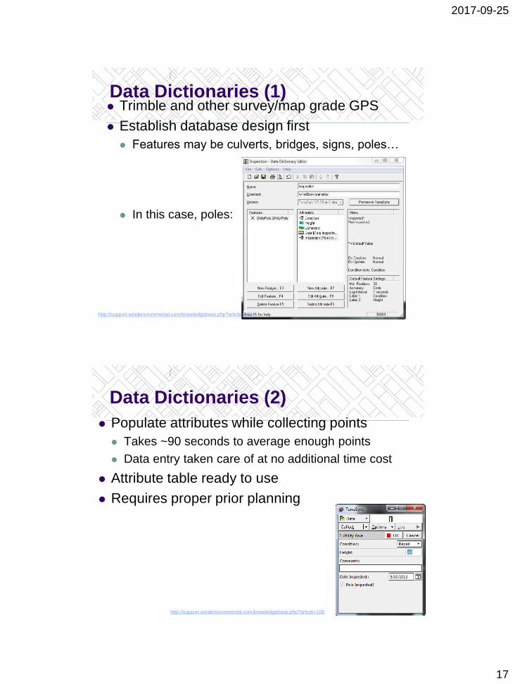
Data Dictionaries (1) Trimble and other survey/map grade GPS
Establish database design first
Features may be culverts, bridges, signs, poles…
In this case, poles:
http://support.windenvironmental.com/knowledgebase.php?article=106
Data Dictionaries (2)
Populate attributes while collecting points
Takes ~90 seconds to average enough points
Data entry taken care of at no additional time cost
Attribute table ready to use
Requires proper prior planning
http://support.windenvironmental.com/knowledgebase.php?article=106

2017-09-25
18
One Bear’s Movement >
• Remote transfer
• Proximity transfer
• Direct transfer
Data Acquisition in 2016
Data BC
ESRI Open Data
GeoDiscover Alberta
BC MoFLNRO
GeoGratis
Prince George
Spatially referenced 99% of the time
Most data publicly available (no $$)

2017-09-25
19
Canadian Data Sources
Canada: https://www.mcgill.ca/library/find/maps/geospatial-online
BC: https://catalogue.data.gov.bc.ca/dataset
Alberta: https://geodiscover.alberta.ca/geoportal/catalog/main/home.page
Saskatchewan: https://www.isc.ca/Pages/Content%20Gallery/GeoSask.aspx
Manitoba: http://www.manitoba.ca/iem/geo/gis/index.html
Ontario: https://www.ontario.ca/page/land-information-ontario
New Brunswick: http://www.snb.ca/geonb1/e/DC/catalogue-E.asp
Nova Scotia: https://geonova.novascotia.ca/
Quebec: https://www.mcgill.ca/library/find/maps (Gov’t data in a non-ESRI format)
Yukon: http://www.geomaticsyukon.ca/
Northwest Territories: http://www.geomatics.gov.nt.ca/dldsoptions.aspx (must register)
Nunavut: http://ntilands.tunngavik.com/maps/
U.S. and Other Data Sources
NASA: http://data.giss.nasa.gov/
Census Data
US Geological Society
Wikipedia’s List of GIS Data Sources

2017-09-25
20
Searching the Web: Keywords Google tips and tricks
Shapefile British Columbia Wildfire
Publicly Available KMLs Sometimes Google Earth is all you get
It’s enough…
▪ It comes in like this:
▪ Right click Polygons>File>Export data>Export as shapefile
▪ Result: usable shapefile/attribute table (turn off extra items)

2017-09-25
21
Shapefiles One “shapefile” = 3 or more files
.shp: shape format/geometry
.shx: shape index format (file navigation)
.dbf: attribute data (the ‘spreadsheet’)
.prj: projection data
.sbn, .sbx, .fbn, .fbx, .ain, .aih, .ixs, .mxs, .atx,
.shp.xml, .cpg, .qix: other formatting files
ALL HAVE TO MOVE TOGETHER
Geodatabases Layers in one place, ready to use + move
Pros: functionality, transferability within Arc
Cons: proprietary format = unreadable
Some newer software is getting around that

2017-09-25
22
Shapefile/GDB Layer InputAdd data from file
Polygon
Line
Point
Table
Raster
Geodatabases
Shapefiles (+text)
Shapefile/GDB Layer Input
Add data from ArcGIS Online

2017-09-25
23
Shapefile/GDB Layer Input
Catalog Tab
Inside ArcMap
Click + Drag to
Table of Contents
ArcCatalog
Click + Drag to
ArcMap Table of
Contents
Add using ArcCatalog or Catalog
Tab
WMS Layer Input
Add data->GIS Servers->add WMS Server
“Get Layers”

2017-09-25
24
Layer Files Layer file stores symbology
Where the files are
How to display them
Which attributes to display/hide
Does NOT include the data itself
Add to map just like a shapefile
Paper Towns: False Input Agloe, New York
Copyright “trap”
Agloe General Store
Beatosu (Beat OSU) and Goblu (Go Blue)
https://www.buzzfeed.com/krystieyandoli/welcome-to-the-agloe-general-store-come-back-soon?utm_term=.gy73AQXmy#.xdyE4mx8j

2017-09-25
25
Summary Digitizing tables are mostly out
Scanning, raster to vector is in
Keyboard data entry is still big… always?
File conversion remains critical
Digitized in 2002, file format…? Use FME
Countless data sources available
Input gets easier by the day
BUT is still the worst source of error