spatium - iaus | srpski 37.pdf · spatium spatium no. 37, june 2017, belgrade issn 1450-569x issn...
TRANSCRIPT


spatium
spatium No. 37, June 2017, Belgrade
ISSN 1450-569XISSN 2217-8066 (Online)
SCOPE AND AIMSThe review is concerned with a multi-disciplinary approach to spatial, regional and urban planning and architecture, as well as with various aspects of land use, including housing, environment and related themes and topics. It attempts to contribute to better theoretical understanding of a new spatial development processes and to improve the practice in the field.
EDITORIAL BOARD
Branislav Bajat, University of Belgrade, Faculty of Civil Engineering, Belgrade, Serbia; Ljiljana Blagojević, Belgrade, Serbia; Giancarlo Cotella, Polytechnic University of Turin, DIST - Interuniversity Department of Regional and Urban Studies and Planning, Turin, Italy; Tijana Crnčević, IAUS, Belgrade, Serbia; Thomas Dillinger, Vienna University of Technology, Faculty of Planning and Architecture, Vienna, Austria; Miša Đurković, Institute for European Studies, Belgrade, Serbia; Evelyn Gustedt, Leibniz Universität Hannover, Akademie für Raumforschung und Landesplanung (ARL), Hannover, Germany; Zeynep Enlil, Yildiz Technical University, Faculty of Architecture, Department of City and Regional Planning, Istanbul, Turkey; Milorad Filipović, University of Belgrade, Faculty of Economics, Belgrade, Serbia; Andrej Gulič, Urban Institute of the Republic of Slovenia, Ljubljana, Slovenia; Augustin Ioan, University of Architecture and Planning “Ion Mincu”, Bucharest, Romania; Fernando Jerez, The University of Western Australia, School of Architecture, Landscape and Visual Arts, Crawley, Australia; Grigoris Kafkalas, Aristotle University of Thesalloniki, Spatial Development and Research Unit – SDRU, Athens, Greece; Elina Krasilnikova, Volgograd State University of Architectural and Civil Engineering - Institute of Architecture and Urban development, Department of Urbanism and Theory of Architecture, Volgograd, Russia; Moscow Region “Research Urban Planning and Design Institute” (SUO “NIiPI Urban Development”), Moscow, Russia; Nikola Krunić, IAUS, Belgrade, Serbia; Marija Maksin, IAUS, Belgrade, Serbia; Tamara Maričić, IAUS, Belgrade, Serbia; Saša Milijić, IAUS, Belgrade, Serbia; Bernhard Müller, Leibniz-Institut für ökologische Raumentwicklung, Dresden, Germany; Zorica Nedović-Budić, University College Dublin, School of Geography, Planning and Environmental Policy, Dublin, Ireland; Mark Oranje, University of Pretoria, Department of Town & Regional Planning, Pretoria, South Africa; George Petrakos, University of Thessaly, School of Engineering, Department of Planning and Regional Development, Volos, Greece; Jasna Petrić, IAUS, Belgrade, Serbia; Mina Petrović, University of Belgrade, Faculty of Philosophy, Department of Sociology, Belgrade, Serbia; Mila Pucar, Belgrade, Serbia; Ratko Ristić, University of Belgrade, Faculty of Forestry, Belgrade, Serbia; Aleksandar Slaev, Varna Free University, Faculty of Architecture, Varna, Bulgaria; Vladimir Stevanović, SANU (Serbian Academy of Sciences and Arts), Belgrade, Serbia; Paolo Tomasella, Regione Autonoma Friuli Venezia Giulia, Udine, Italy; Paul Waley, University of Leeds, School of Geography, Leeds, UK; and Slavka Zeković, IAUS, Belgrade, Serbia.
PUBLISHING COUNCIL
Branislav Bajat, University of Belgrade, Faculty of Civil Engineering, Belgrade, Serbia; Tijana Crnčević, IAUS, Belgrade, Serbia; Mirjana Devetaković, University of Belgrade, Faculty of Architecture, Belgrade, Serbia; Branka Dimitrijević, University of Strathclyde, Department of Architecture and Building Science, Glasgow, UK; Omiljena Dželebdžić, IAUS, Belgrade, Serbia; Milorad Filipović, University of Belgrade, Faculty of Economics, Belgrade, Serbia; Boško Josimović, IAUS, Belgrade, Serbia; Nikola Krunić, IAUS, Belgrade, Serbia; Ksenija Lalović, University of Belgrade, Faculty of Architecture, Belgrade, Serbia; Jelena Luković, University of Belgrade, Faculty of Geography, Belgrade, Serbia; Božidar Manić, IAUS, Belgrade, Serbia; Igor Marić, IAUS, Belgrade, Serbia; Tamara Maričić, IAUS, Belgrade, Serbia; Saša Milijić, IAUS, Belgrade, Serbia; Zorica Nedović-Budić, University College Dublin, School of Geography, Planning and Environmental Policy, Dublin, Ireland; Marina Nenković-Riznić, IAUS, Belgrade, Serbia; Mina Petrović, University of Belgrade, Faculty of Philosophy, Belgrade, Serbia; Mila Pucar, Belgrade, Serbia; Ratko Ristić, University of Belgrade, Faculty of Forestry, Belgrade, Serbia; Borislav Stojkov, Belgrade, Serbia; Dragutin Tošić, University of Belgrade, Faculty of Geography, Belgrade, Serbia; and Miodrag Vujošević, IAUS, Belgrade, Serbia.
EDITOR-IN-CHIEFMiodrag Vujošević, IAUS, Belgrade, Serbia
TECHNICAL EDITORTanja Bajić, IAUS, Belgrade, Serbia
SECRETARYMilena Milinković, IAUS, Belgrade, Serbia
PUBLISHING COUNCILJasna Petrić, President, IAUS, Belgrade, SerbiaAna Niković, Vice President, IAUS, Belgrade, SerbiaMilena Milinković, Secretary, IAUS, Belgrade, Serbia
PUBLISHER Institute of Architecture and Urban & Spatial Planning of Serbia, IAUSSaša Milijić, Director
ADDRESSInstitute of Architecture and Urban & Spatial Planning of Serbia, IAUS SpatiumSerbia, 11000 Belgrade, Bulevar kralja Aleksandra 73/IItel: (381 11) 3207-300, fax: (381 11) 3370-203 e-mail: [email protected], web address: www.iaus.ac.rs
FINANCIAL SUPPORTMinistry of Education, Science and Technological Development of the Republic of Serbia Spatium is indexed in SCOPUS and SCImago.
ENGLISH LANGUAGE PROOFREADINGSonja Stojanović, Niš, SerbiaMarija Obadović, Belgrade, Serbia
COMPUTER DESIGNAleksandra Gajić, Belgrade, Serbia
COVER PAGE DESIGN Tanja Bajić, IAUS, Belgrade, Serbia
Cover page illustration: Cerak Vinogradi Settlement in Belgrade, 1978-1987, from documentation of Milenija Marušić
Printed in Serbia by “PLANETA PRINT”, Belgrade, SerbiaNumber of copies: 200
REVIEWERS
Vera Backović, University of Belgrade, Faculty of Philosophy, Department of Sociology, Belgrade, Serbia; Ratka Čolić, University of Belgrade, Faculty of Architecture, Belgrade, Serbia; Branka Dimitrijević, University of Strathclyde, Department of Architecture and Building Science, Glasgow, United Kingdom; Dejan Đorđević, University of Belgrade, Faculty of Geography, Belgrade, Serbia; Miroljub Hadžić, Singidunum University, Belgrade, Serbia; Nikola Krunić, IAUS, Belgrade, Serbia; Božidar Manić, IAUS, Belgrade, Serbia; Vladimir Milenković, University of Belgrade, Faculty of Architecture, Belgrade, Serbia; Jasna Petrić, IAUS, Belgrade, Serbia; Jelena Petrić, Glasgow, United Kingdom; Jovan Popesku, Singidunum University, Belgrade, Serbia; Mila Pucar, Belgrade, Serbia; Uroš Radosavljević, University of Belgrade, Faculty of Architecture, Belgrade, Serbia; Ashraf M. Salama, University of Strathclyde, Department of Architecture, Glasgow, United Kingdom; Aleksandar D. Slaev, Varna Free University, Faculty of Architecture, Varna, Bulgaria; Borislav Stojkov, Belgrade, Serbia; Paolo Tomasella, Regione Autonoma Friuli Venezia Giulia, Udine, Italy; Dobrivoje Tošković, Belgrade, Serbia; Tijana Vujošević, The University of Western Australia, School of Architecture, Landscape and Visual Arts, Perth, Australia; and Slavka Zeković, IAUS, Belgrade, Serbia.


spatium
C O N T E N T SSPATIUM No. 37, June 2017, Belgrade
Miodrag Vujošević Editorial
1 - 11 Georgia Gemenetzi Exploring the relationship between urban sprawl and the urban system. Evidence from Thessaloniki, 1991-2011.
12 - 21 Dijana Milašinović Marić,Marta Vukotić Lazar
Modernism versus postmodernism as an impetus to creativity in the work of architects Milenija and Darko Marušić
22 - 33 Ashraf M. Salama,Adel M. Remali,Laura MacLean
Characterisation and systematic assessment of urban open spaces in Glasgow City Centre
34 - 41 Atanas Kovachev,Aleksandar D. Slaev,Slavka Zeković,Tamara Maričić,Diliana Daskalova
The changing roles of planning and the market in the processes of urban growth in Belgrade and Sofia
42 - 48 Saša Milijić,Srđan Mićić,Marija Maksin
Retrospective of and prospects for the development and strategic planning of tourism in the mountain regions of Serbia
49 - 57 Ana Perić,Milutin Miljuš
Spatial and urban planning in Serbia: a look through the lens of deliberative approach
58 - 65 Nebojša Stefanović,Nataša Danilović Hristić,Nikola Krunić
Comparative analysis of elements and models of implementation in local-level spatial plans in Serbia
66 - 73 Milan Šijaković,Tanja Bajić
Architectural dimension of sustainability: re-establishing the concept of recycling
74 - 81 Miroslava Petrović Balubdžić Creating the Belgrade Waterfront identity through a prism of architecture and urban planning competitions


spatium
EDITORIAL
Dear readers,
The theme of urban sprawl and growth, sustainability and related issues feature as a core frame in this issue of SPATIUM, in the first place in the contribution by a Greek author, as well as in the contribution of a group of authors who participated in the International Project TURaS (Transitioning Towards Urban Resilience and Sustainability), focusing on the issues of the role and market and planning in the pertinent processes. Also, a paper on the architectural aspect of sustainability has been presented here, in parallel to a contribution on urban open spaces in Glasgow. Another contribution deals with more theoretical aspects of spatial and urban planning in Serbia (deliberative approach), and three another papers on some strategic aspects of tourism planning in Serbia, implementation of local-level spatial plans in Serbia, and on creating Belgrade waterfront identity. On this occasion some aspects of the work of two outstanding Serbian architects have also been presented and commented on in this issue.
Miodrag VujoševićEditor-in-Chief


1spatium
INTRODUCTION
There is growing concern over urban sprawl from professionals, politicians and academics. Although European cities have traditionally been much more compact compared to most American cities, sprawl constitutes a common challenge throughout Europe due to its environmental, social and economic impacts (CEC, 1999). Urban sprawl is generally considered to be an undesirable type of urban development (Hennig et al., 2015; Zeković et al., 2015), usually related to low-density urban expansion into surrounding rural areas (EEA, 2006).
In Europe, urban sprawl originated back in the post-war decades and since the 1970s, it has been associated with suburbanisation. However, there are significant differences regarding the processes and patterns of sprawl between North and South European cities. The anti-urban geographical imaginations of Northern cultures drove life-styled urban sprawl creating satellite suburbs in the search for a rural idyll within a 50km commuter range. Contrary to controlled suburbanisation, in Mediterranean Europe middle classes left the inner-city-area sprawling outwards at
relatively short distances (around 20km) (Leontidou, 1990). Urban sprawl has intensified in large Northern European cities since the 1980s through deconcentration trends along with the parallel absolute loss of population and workplaces from the inner urban areas (Hall and Pain, 2006). Further, urban sprawl has become even more far-reaching through the emergence of secondary economic poles at railroad intersections (Bontje and Burdack, 2005). In Southern Europe, population and workplace deconcentration intensified in the 1990s (Leontidou, 1990; Paul and Tonts, 2005). In particular, large-scale infrastructural projects have driven urban sprawl via ribbon development patterns and the conversion of secondary homes into primary ones (Leontidou et al., 2007).
Urban sprawl is usually examined in the metropolitan level (Laidley, 2016; Hamidi and Ewing 2014; Sarzynski et al., 2014; Ewing et al., 2002; Galster et al., 2001; Fulton et al., 2001; Downs, 1998 etc.), even though sprawl seems also to have a multi-scalar approach (Hennig et al., 2015), ranging from local to regional scales. The urban structure seems to evolve through the intensification of the urban sprawl phenomenon in contradictory ways. Therefore, several scholars focus on polycentric aspects of urban sprawl (Sarzynski et al., 2014; Hamidi and Ewing, 2014; Cutsinger
EXPLORING THE RELATIONSHIP BETWEEN URBAN SPRAWL AND THE URBAN SYSTEM.
EVIDENCE FROM THESSALONIKI, 1991-2011.
Georgia Gemenetzi1, University of Thessaloniki, Department of Architecture, Thessaloniki, Greece
The article explores the relationship between urban sprawl and the urban system. Urban sprawl is not considered to be a static, unsustainable urban form, but rather a dynamic process of urban deconcentration through which the urban structure evolves. After identifying the main characteristics of urban sprawl, this article investigates the connection between urban sprawl and the urban system through the concept of polycentricity. Finally, the two-way relationship between urban sprawl and the urban system is highlighted. Based on the above, an integrated theoretical, conceptual and methodological framework is formulated. A key finding was the emergence of ‘small-scale’ polycentricity, which implies increasing monocentricity over a wider spatial area. This raises questions over the distinction between the negative phenomenon of urban sprawl and sustainable polycentric forms, and points out a need to review the explanatory devices and theories used in spatial analysis and planning. Empirical evidence was extracted from Thessaloniki’s Influence Area.Key words: urban sprawl, polycentricity, urban system, deconcentration, spatial analysis and planning.
1 Kuzikou 35, Kalamaria, 55133, Greece [email protected]
UDC 711.4(495)”1991/2011”Original scientific paperDOI: https://doi.org/10.2298/SPAT1737001G
SPATIUM No. 37, June 2017, pp. 1-11
2 spatium
et al., 2005), whereas others (Salvati, 2016; Gordon et al, 1998) equate sprawl – often in monocentric cities – with suburbanisation resulting in dispersed urban form.
Taking these into account, this study aims to formulate an integrated theoretical, conceptual and methodological framework regarding the relationship between urban sprawl and the urban system. In short, it dissociates urban sprawl from its usual conceptualisation as an urban-scale low density expansion, and it reconsiders sprawl as a dynamic process of urban deconcentration that may gradually change the spatial urban structure at the metropolitan level towards a more polycentric pattern.
The main steps in this study’s methodology are the following and they are identified with the structural parts of this study:
1. Review the approaches regarding urban sprawl so as to develop a new definition.
2. Consider the urban system through the concept of polycentricity.
3. Analyse the theoretical and conceptual relationships between urban sprawl and the urban system, with polycentricity as the bridging concept and framework for the central hypothesis to be formulated.
4. Develop a methodological framework that can be applied in any empirical field that meets the necessary requirements.
5. Test the hypothesis in the selected empirical field and use the results to reflect on the explanatory devices and theories used in spatial analysis and development.
DEFINING URBAN SPRAWL: A LITERATURE REVIEW
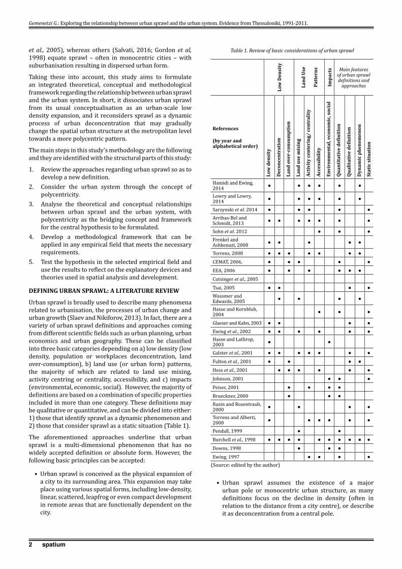
Urban sprawl is broadly used to describe many phenomena related to urbanisation, the processes of urban change and urban growth (Slaev and Nikiforov, 2013). In fact, there are a variety of urban sprawl definitions and approaches coming from different scientific fields such as urban planning, urban economics and urban geography. These can be classified into three basic categories depending on a) low density (low density, population or workplaces deconcentration, land over-consumption), b) land use (or urban form) patterns, the majority of which are related to land use mixing, activity centring or centrality, accessibility, and c) impacts (environmental, economic, social). However, the majority of definitions are based on a combination of specific properties included in more than one category. These definitions may be qualitative or quantitative, and can be divided into either: 1) those that identify sprawl as a dynamic phenomenon and 2) those that consider sprawl as a static situation (Table 1).
The aforementioned approaches underline that urban sprawl is a multi-dimensional phenomenon that has no widely accepted definition or absolute form. However, the following basic principles can be accepted:
• Urban sprawl is conceived as the physical expansion of a city to its surrounding area. This expansion may take place using various spatial forms, including low-density, linear, scattered, leapfrog or even compact development in remote areas that are functionally dependent on the city.
• Urban sprawl assumes the existence of a major urban pole or monocentric urban structure, as many definitions focus on the decline in density (often in relation to the distance from a city centre), or describe it as deconcentration from a central pole.
Gemenetzi G.: Exploring the relationship between urban sprawl and the urban system. Evidence from Thessaloniki, 1991-2011.
Low
Den
sity
Land
Use
Patt
erns
Impa
cts Main features
of urban sprawl definitions and
approaches
References
(by year and alphabetical order)
Low
den
sity
Dec
once
ntra
tion
Land
ove
r-co
nsum
ptio
n
Land
use
mix
ing
Activ
ity
cent
erin
g/ c
entr
alit
y
Acce
ssib
ility
Envi
ronm
enta
l, ec
onom
ic, s
ocia
l
Qua
ntit
ativ
e de
finit
ion
Qua
litat
ive
defin
itio
n
Dyn
amic
phe
nom
enon
Stat
ic s
itua
tion
Hamidi and Ewing, 2014 ● ● ● ● ● ●
Lowry and Lowry, 2014 ● ● ● ● ● ●
Sarzynski et al. 2014 ● ● ● ● ●
Arribas-Bel and Schmidt, 2013 ● ● ● ● ● ● ●
Sohn et al. 2012 ● ● ●
Frenkel and Ashkenazi, 2008 ● ● ● ● ●
Torrens, 2008 ● ● ● ● ● ● ●
CEMAT, 2006, ● ● ● ● ●
EEA, 2006 ● ● ● ● ● ●
Cutsinger et al., 2005
Tsai, 2005 ● ● ● ●
Wassmer and Edwards, 2005 ● ● ● ●
Hasse and Kornbluh, 2004 ● ● ●
Glaeser and Kahn, 2003 ● ● ● ●
Ewing et al., 2002 ● ● ● ● ● ●Hasse and Lathrop, 2003 ● ●
Galster et al., 2001 ● ● ● ● ● ● ●
Fulton et al., 2001 ● ● ● ●
Hess et al., 2001 ● ● ● ● ● ●
Johnson, 2001 ● ● ●
Peiser, 2001 ● ● ● ●
Brueckner, 2000 ● ● ●
Razin and Rosentraub, 2000 ● ● ● ●
Torrens and Alberti, 2000 ● ● ● ● ● ●
Pendall, 1999 ● ●
Burchell et al., 1998 ● ● ● ● ● ● ● ● ● ●
Downs, 1998 ● ● ●
Ewing, 1997 ● ● ● ●
(Source: edited by the author)
Table 1. Review of basic considerations of urban sprawl

3spatium
• Poor accessibility from one activity to another – commuting likely being the most common index – is an indication of urban sprawl. Specifically, the shift in accessibility or increase in travel distance denotes sprawl intensification, and is related to housing or workplaces in more remote areas.
• Urban sprawl is commonly perceived as a negative and unsustainable type of urban development related to inadequate planning.
• Urban sprawl can be considered a static urban form regarding its spatial characteristics, or a spatiotemporal, dynamic process regarding its socioeconomic shifts and spatial changes.
Therefore, when taking into account that urban sprawl is a dynamic phenomenon, it can be recognised through three considerations (Figure 1):
1. Urban expansion of a city to its surrounding area.
2. Urban deconcentration of a city to its surrounding area.
3. Enlargement of the city’s periphery because of increased commuting distances.
These considerations relate the phenomenon of urban sprawl to the key assumption of the existence of a monocentric urban structure, since the dominance of a (focal) city surrounded by its periphery shapes, by definition, a spatial structure organised on the principles of centrality and, therefore, a monocentric structure clearly distinguished from a polycentric one (Parr, 2004:234).
Taking these considerations into account, urban sprawl is defined as a dynamic process of deconcentration from an urban centre to its surrounding influence area alongside spatial expansion.
CONSIDERING THE URBAN SYSTEM THROUGH THE POLYCENTRICITY CONCEPT
The central place theory of Christaller (1966/1933) and the theory of urbanisation cycle (Berry, 1976, Klaassen et al., 1981, Van den Berg et al., 1982), usually used to describe the organisation of the urban system, have currently been displaced by the concept of polycentricity. Polycentricity has been used both as an analytical tool to explain the structure of the urban system and as a planning tool or vision to promote spatial development (Davoudi, 2003:979).
Even though polycentricity is a multi-scalar concept that encompasses different levels ranging from the intra-urban to the European (Davoudi, 2003; ESPON, 2003b; Kloosterman and Musterd, 2001; Parr, 2004), it is most commonly applied to functional urban areas (Vasanen, 2012:3628) or inter-urban levels.
From an etymological point of view, polycentricity concerns the plurality of centres. Studies on polycentricity consider three dimensions of centres: 1) size, 2) (spatial) position and 3) connectivity. Dimensions (1) and (2) express the morphological approach of polycentricity and dimension (3) encompasses the functional one (ESPON, 2005:60-61).
However, the definition and the weighting of factors used to measure centrality are not uniform. Population is the prime indicator for ranking the size of centres in an urban system (Champion, 2001:664), although the number of workplaces is also commonly used (Hall and Pain, 2006:20). Networking in terms of material and immaterial flows is also gaining increasing importance in the analysis of urban systems (Burger et al., 2015; Vasanen, 2012; Hall and Pain, 2006). However, there is no clear method to measure polycentricity (Burger and Meijers, 2012:1144; Meijers, 2008; Davoudi, 2003:979). The empirical assessment of polycentricity predominantly considers national scales and is based on strict quantitative indicators – such as the slope of the regression line of the rank-size distribution of Functional Urban Areas – whereas there are no specifications ‘about the rationales for using their indicators and their weighting’ (Meijers, 2008:1319).
Polycentricity is a state between concentration and deconcentration, or in other words, between the theoretical extremes of: 1) monocentricity, referring to the gathering of people and activities at one unique location and 2) dispersal, referring to the equal distribution of people and activities over space (ESPON, 2003a:.6,7,13). The optimum degree of polycentricity represents an intermediate state between monocentricity and dispersal (ESPON, 2003a:7), and constitutes a balanced distribution of centres in a territory. Morphological and functional polycentricity are both concerned with ‘the balance in the importance of urban centres in a given area’ (Burger and Meijers, 2012:1144).
The ideal degree of polycentricity may be defined qualitatively through the concepts of ‘concentrated deconcentration’ (Bontje, 2001:770), ‘decentralized concentration’ (Knaap, 1998:385) or ‘deconcentrated clustering’ (Albrechts, 1998:417, 422). In truth, all of these approaches envisage a new balance that could be termed ‘deconcentrated concentration’ that reflects the guided deconcentration (usually) of population and urban activities
Gemenetzi G.: Exploring the relationship between urban sprawl and the urban system. Evidence from Thessaloniki, 1991-2011.
Figure 1. Basic considerations of urban sprawl (Source: edited by the author)

4 spatium
to selected centres clustered around the central pole in order to reduce inequalities.
To sum up, the degree of polycentricity increases the most when the size of centres, their spatial position and the interrelationships between them are evenly distributed. Thus, an urban system becomes more polycentric when: 1) the differences in size between centres decreases, 2) old and emerging centres have a more uniform distribution in a territory 3) the flows between the centres increase and have a criss-cross multidirectional pattern.
The ideal form of polycentricity constitutes a totally functionally and spatially balanced urban system in which all centres are of equal size and situated at equal distances (ESPON, 2005).
FORMULATING THE HYPOTHESIS: FROM URBAN SPRAWL TO POLYCENTRIC DEVELOPMENT
Champion (2001:663-666) analysed the ways in which an urban area or a region’s structure may evolve into a Polycentric Urban Region by taking into account the number and size of centres, their spatial extent and level of interaction. According to Champion there are at least three alternative paths from which a polycentric urban region may emerge: the centrifugal mode, the incorporation mode and the fusion mode. The centrifugal mode refers to a monocentric city whose continuing growth leads to the creation of alternative centres that are smaller or equivalent in size to the original centre. The incorporation mode refers to the expansion of the urban field of a large urban centre by incorporating smaller pre-existing centres from the surrounding area. The fusion mode refers to the fusion of two or more centres or cities that have been previously developed more or less independently of each other and are situated in close proximity, as a result of their own separate growth both in overall size and spatial extension.
In fact, the incorporation and centrifugal modes assume the presence of a monocentric urban structure, whereas the fusion mode is based on the premise of a polycentric urban structure. The outcome of these modes is increased polycentricity of all new urban structures.
Taking into account the three aforementioned basic considerations of urban sprawl and Champion’s views on the alternative processes for a more polycentric structure, the central hypothesis is formulated as follows:
Urban sprawl may change the structure of the urban system towards polycentricity. More specifically:
1. The approach of urban sprawl as urban deconcentration corresponds to the centrifugal mode, and consequently to the formulation or strengthening of secondary centres.2. Urban expansion, which is a main feature of urban sprawl, simulates the fusion mode through the merging of existing centres, implying a plurality of centres in a given territory. 3. The approach of urban sprawl as an enlargement of the city’s periphery corresponds with the spatial and functional expansion of an urban centre’s influence area, which leads to the incorporation of pre-existing centres, and thus an increase in polycentricity.
Urban deconcentration refers to the deconcentration of population and urban functions, such as workplaces, tertiary sector activities or specialised services. The notion of deconcentration is approached in many ways (Mitchell, 2004:17-21). Traditionally, it is associated with the movement (relocation) of population and urban functions from a centre to its periphery and a decrease in the percentage share of the population or urban functions occupying the centre. Urban expansion is associated with an increase in land use for urban purposes, reflecting the spatial and morphological dimension of urban sprawl. However, the change in land use presumes a focus on the lowest spatial level. Finally, the geographical expansion of a city’s boundaries into peripheral areas also implies deconcentration because of the peripheral increases in population and urban functions caused by the incorporation of pre-existing settlements.
Thus, the main research question is:
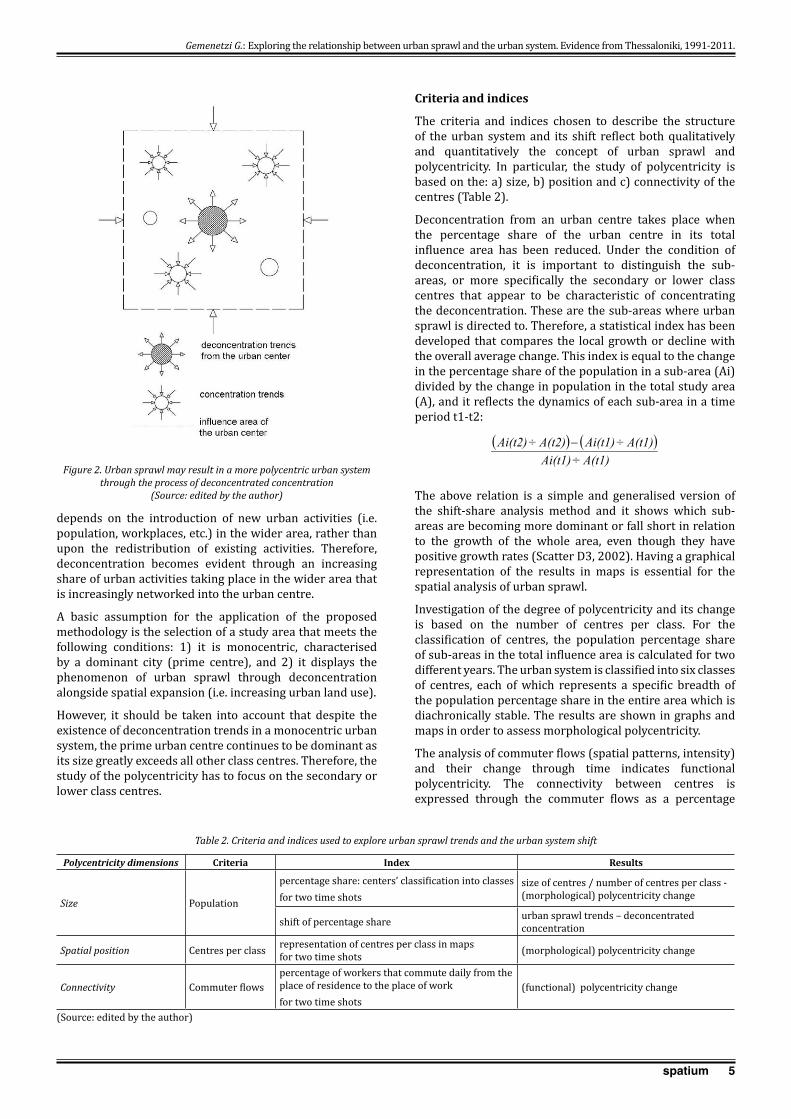
Can urban sprawl contribute to a more polycentric urban system, through the process of ‘deconcentrated concentration’? (Figure 2).
Such an investigation is of crucial importance because urban sprawl is considered an unsustainable type of urban growth, contrary to the concept of polycentricity that is a strategic key policy option for sustainable development.
The secondary methodological research questions are the following:
• How are the deconcentration trends distributed in the influence area of the central city? Are they distributed in a uniform way, showing trends of generalised dispersion or in an uneven way showing signs of selective reconcentration trends around lower class centres which transform them to secondary or third class centres?
• How are these trends related to the pre-existing structure of the urban system?
METHODOLOGICAL FRAMEWORk AND FIELD OF APPLICATION
Basic methodological approach
The basic principle of the methodological approach for studying the urban system shift – being more or less polycentric – is the investigation of the deconcentration process, and particularly the identification of centres that appear as characteristics of deconcentrated concentration, namely centres that attract influxes from the prime centre. Therefore, urban sprawl and deconcentration are studied through overall urban growth trends that highlight urban system dynamics.
The relative change in the sizes of centres is based on a dynamic process of concentration and deconcentration that takes place within the urban system. This shift is influenced by two factors: 1) the internal changes, namely the movements that take place within the urban system, and 2) the external input and its distribution in the urban system. According to Berry and Horton (1970:88), the emergence of new centres and the shift in the relative sizes of old ones
Gemenetzi G.: Exploring the relationship between urban sprawl and the urban system. Evidence from Thessaloniki, 1991-2011.
5spatium
depends on the introduction of new urban activities (i.e. population, workplaces, etc.) in the wider area, rather than upon the redistribution of existing activities. Therefore, deconcentration becomes evident through an increasing share of urban activities taking place in the wider area that is increasingly networked into the urban centre.
A basic assumption for the application of the proposed methodology is the selection of a study area that meets the following conditions: 1) it is monocentric, characterised by a dominant city (prime centre), and 2) it displays the phenomenon of urban sprawl through deconcentration alongside spatial expansion (i.e. increasing urban land use).
However, it should be taken into account that despite the existence of deconcentration trends in a monocentric urban system, the prime urban centre continues to be dominant as its size greatly exceeds all other class centres. Therefore, the study of the polycentricity has to focus on the secondary or lower class centres.
Criteria and indices
The criteria and indices chosen to describe the structure of the urban system and its shift reflect both qualitatively and quantitatively the concept of urban sprawl and polycentricity. In particular, the study of polycentricity is based on the: a) size, b) position and c) connectivity of the centres (Table 2).
Deconcentration from an urban centre takes place when the percentage share of the urban centre in its total influence area has been reduced. Under the condition of deconcentration, it is important to distinguish the sub-areas, or more specifically the secondary or lower class centres that appear to be characteristic of concentrating the deconcentration. These are the sub-areas where urban sprawl is directed to. Therefore, a statistical index has been developed that compares the local growth or decline with the overall average change. This index is equal to the change in the percentage share of the population in a sub-area (Ai) divided by the change in population in the total study area (A), and it reflects the dynamics of each sub-area in a time period t1-t2:
( ) ( )A(t1)÷Ai(t1)
A(t1)÷Ai(t1)A(t2)÷Ai(t2) −
The above relation is a simple and generalised version of the shift-share analysis method and it shows which sub-areas are becoming more dominant or fall short in relation to the growth of the whole area, even though they have positive growth rates (Scatter D3, 2002). Having a graphical representation of the results in maps is essential for the spatial analysis of urban sprawl.
Investigation of the degree of polycentricity and its change is based on the number of centres per class. For the classification of centres, the population percentage share of sub-areas in the total influence area is calculated for two different years. The urban system is classified into six classes of centres, each of which represents a specific breadth of the population percentage share in the entire area which is diachronically stable. The results are shown in graphs and maps in order to assess morphological polycentricity.
The analysis of commuter flows (spatial patterns, intensity) and their change through time indicates functional polycentricity. The connectivity between centres is expressed through the commuter flows as a percentage
Gemenetzi G.: Exploring the relationship between urban sprawl and the urban system. Evidence from Thessaloniki, 1991-2011.
Figure 2. Urban sprawl may result in a more polycentric urban system through the process of deconcentrated concentration
(Source: edited by the author)
Polycentricity dimensions Criteria Index Results
Size Population
percentage share: centers’ classification into classesfor two time shots
size of centres / number of centres per class - (morphological) polycentricity change
shift of percentage share urban sprawl trends – deconcentrated concentration
Spatial position Centres per class representation of centres per class in maps for two time shots (morphological) polycentricity change
Connectivity Commuter flows percentage of workers that commute daily from the place of residence to the place of work for two time shots
(functional) polycentricity change
(Source: edited by the author)
Table 2. Criteria and indices used to explore urban sprawl trends and the urban system shift
6 spatium
of the number of workers that commute daily from their place of residence to their workplace, to the total number of workers.
Application Field: Thessaloniki’s Influence Area
The Influence Area of Thessaloniki is considered as an appropriate field for the empirical testing of the above-formulated hypothesis and research questions because it is a monocentric urban structure in which urban sprawl trends are identified. Thessaloniki is the second-largest city in Greece, with almost 800,000 inhabitants. Its metropolitan area, referred to as the Greater Area of Thessaloniki in the Master Plan (1986), has dynamic economic and demographic growth rates and its population has reached almost one million people.
Thessaloniki is a compact city with high densities, formed by an urban explosion before the end of the 1960s and diffuse urbanisation in the 1970s. Since the late 1980s urban sprawl trends have been relatively limited and spatially confined to smaller adjacent settlements. However, middle class suburbanisation and the generalised expansion of urban activities, mainly in the tertiary sector, intensified in the 1990s. The booming speculative building sector, ring road construction, the planning of new major roads and the increase in private car ownership increased distances between workplaces and residences and set off urban sprawl.
Currently, the Influence Area of Thessaloniki has exceeded the boundaries of the institutionally defined metropolitan area, shaping a larger city-region. It is divided into two macro-zones: 1) the Urban Centre, which coincides with the Urban Agglomeration of Thessaloniki (UATh) and has more than 300,000 workplaces, and 2) the Larger Urban Zone, which represents the whole area impacted by the UATh. This is comprised of 23 Municipal Units, considered to be sub-areas, of which more than 7.5% of the employed residents commute daily in the urban centre.
This study explored the research question in the empirical field from the period of 1991-2011 for two reasons. First, the migration from Athens and Thessaloniki to rural areas began in the 1980s, resulting in rural and semi-urban areas experiencing population growth and urban sprawl, which is likely to be intensified in the next decade. Second, since the early 1990s, Greek cities have witnessed the consequences of the new conditions: accession into the European Union and open boundaries, escalating competition, market deregulation, infrastructure completion and the influx of economic immigrants, along with a period of economic growth that drove in entry into the Euro-zone in 2001. Increased income, completion of transportation infrastructure, increased private car ownership, middle-class land speculations and private investments in new home developments fuelled urban sprawl. However, the financial crisis that broke out in 2009 almost halted urban sprawl.
EMPIRICAL TESTING: ANALYSIS AND FINDINGS
Population deconcentration and polycentricity trends in the influence area of Thessaloniki, 1991-2011
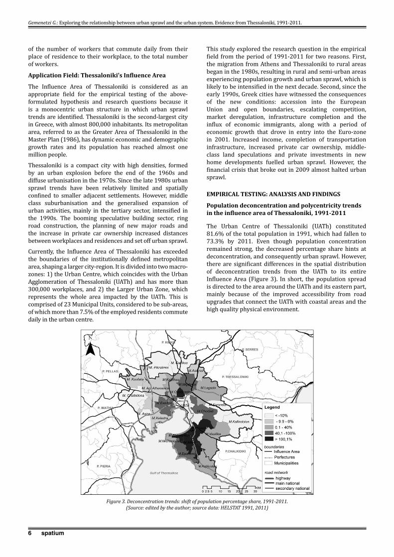
The Urban Centre of Thessaloniki (UATh) constituted 81.6% of the total population in 1991, which had fallen to 73.3% by 2011. Even though population concentration remained strong, the decreased percentage share hints at deconcentration, and consequently urban sprawl. However, there are significant differences in the spatial distribution of deconcentration trends from the UATh to its entire Influence Area (Figure 3). In short, the population spread is directed to the area around the UATh and its eastern part, mainly because of the improved accessibility from road upgrades that connect the UATh with coastal areas and the high quality physical environment.
Gemenetzi G.: Exploring the relationship between urban sprawl and the urban system. Evidence from Thessaloniki, 1991-2011.
Figure 3. Deconcentration trends: shift of population percentage share, 1991-2011. (Source: edited by the author; source data: HELSTAT 1991, 2011)
7spatium
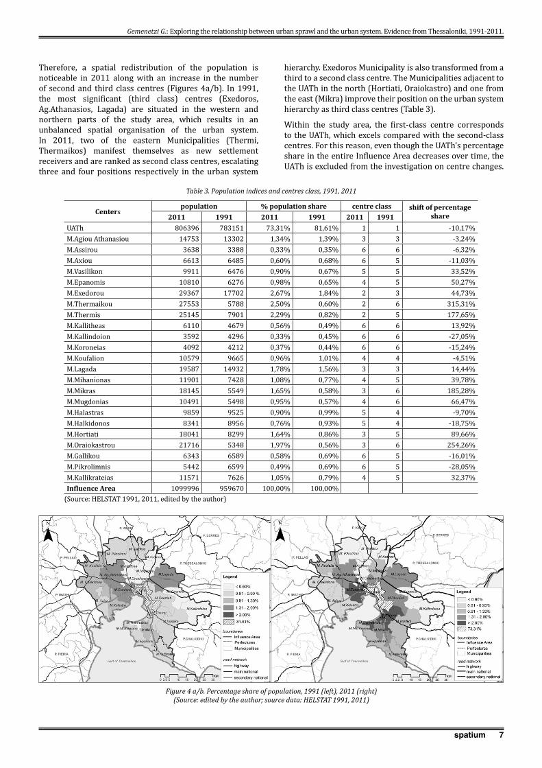
Therefore, a spatial redistribution of the population is noticeable in 2011 along with an increase in the number of second and third class centres (Figures 4a/b). In 1991, the most significant (third class) centres (Exedoros, Ag.Athanasios, Lagada) are situated in the western and northern parts of the study area, which results in an unbalanced spatial organisation of the urban system. In 2011, two of the eastern Municipalities (Thermi, Thermaikos) manifest themselves as new settlement receivers and are ranked as second class centres, escalating three and four positions respectively in the urban system
hierarchy. Exedoros Municipality is also transformed from a third to a second class centre. The Municipalities adjacent to the UATh in the north (Hortiati, Oraiokastro) and one from the east (Mikra) improve their position on the urban system hierarchy as third class centres (Table 3).
Within the study area, the first-class centre corresponds to the UATh, which excels compared with the second-class centres. For this reason, even though the UATh’s percentage share in the entire Influence Area decreases over time, the UATh is excluded from the investigation on centre changes.
Centerspopulation % population share centre class shift of percentage
share2011 1991 2011 1991 2011 1991UATh 806396 783151 73,31% 81,61% 1 1 -10,17%M.Agiou Athanasiou 14753 13302 1,34% 1,39% 3 3 -3,24%M.Assirou 3638 3388 0,33% 0,35% 6 6 -6,32%M.Axiou 6613 6485 0,60% 0,68% 6 5 -11,03%M.Vasilikon 9911 6476 0,90% 0,67% 5 5 33,52%M.Epanomis 10810 6276 0,98% 0,65% 4 5 50,27%M.Exedorou 29367 17702 2,67% 1,84% 2 3 44,73%M.Thermaikou 27553 5788 2,50% 0,60% 2 6 315,31%M.Thermis 25145 7901 2,29% 0,82% 2 5 177,65%M.Kallitheas 6110 4679 0,56% 0,49% 6 6 13,92%M.Kallindoion 3592 4296 0,33% 0,45% 6 6 -27,05%M.Koroneias 4092 4212 0,37% 0,44% 6 6 -15,24%M.Koufalion 10579 9665 0,96% 1,01% 4 4 -4,51%M.Lagada 19587 14932 1,78% 1,56% 3 3 14,44%M.Mihanionas 11901 7428 1,08% 0,77% 4 5 39,78%M.Mikras 18145 5549 1,65% 0,58% 3 6 185,28%M.Mugdonias 10491 5498 0,95% 0,57% 4 6 66,47%M.Halastras 9859 9525 0,90% 0,99% 5 4 -9,70%M.Halkidonos 8341 8956 0,76% 0,93% 5 4 -18,75%M.Hortiati 18041 8299 1,64% 0,86% 3 5 89,66%M.Oraiokastrou 21716 5348 1,97% 0,56% 3 6 254,26%M.Gallikou 6343 6589 0,58% 0,69% 6 5 -16,01%M.Pikrolimnis 5442 6599 0,49% 0,69% 6 5 -28,05%M.Kallikrateias 11571 7626 1,05% 0,79% 4 5 32,37%Influence Area 1099996 959670 100,00% 100,00%
(Source: HELSTAT 1991, 2011, edited by the author)
Table 3. Population indices and centres class, 1991, 2011
Figure 4 a/b. Percentage share of population, 1991 (left), 2011 (right) (Source: edited by the author; source data: HELSTAT 1991, 2011)
Gemenetzi G.: Exploring the relationship between urban sprawl and the urban system. Evidence from Thessaloniki, 1991-2011.

8 spatium
A homogeneous population trend is observed around the UATh, while centres adjacent to the UATh, significantly reduce the discrepancies between them.
Therefore, concerning the size of the centres, the urban system becomes more polycentric as the number of higher class centres (second to fourth) increases, and therefore the percentage share of their population increases as well (Figure 5a/b). Concerning the spatial position of the centres, the polycentricity of the urban system is strengthened by a more balanced spatial distribution of the centres (per class) between the east and west of the influence area (Figure 4a/b).
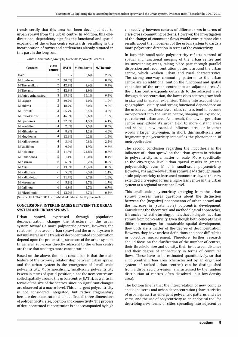
Commuter flows: an index for functional polycentricity, 2011
The change of the commuter flows is a significant index for the study of functional polycentricity change. Since there are no available statistical data for 1991, the empirical study focuses on the study of existing functional polycentricity using 2011 data.
The most powerful commuting flows (>20%) are recorded between the UATh and the municipalities in the eastern area as well as the municipalities in the western area with a larger population (Figure 6). Echedoros Municipality in the west and Thermi Municipality in the east are among the most significant secondary (population and workplace) centres, but they are the only centres that simultaneously constitute the second more powerful poles for commuters (Table 4). In general, the western subsystem of the study area is characterised by more complicated commuting patterns compared to the eastern one. It also shows weaker dependency on the UATh, since several western and south-western municipalities show very weak (5-9.9%) or weak (10-19.9%) commuting flows. This relates to the western area’s historical evolution and concentration of industrial activity. In 2011, the entire eastern area shows strong dependency on the UATh (>20%). This is a sign of its recent growth as an integral, functional part of Thessaloniki as a settlement receiver. The one-way strong commuter flows in combination with the deconcentrated concentration
Figure 6. Commuter flows, 2011(Source: edited by the author; source data: HELSTAT 2011)
Figure 5a and b. Number of centres and percentage share of population per class, 1991, 2011. (Source: edited by the author; source data: Figures 4a/b)
Gemenetzi G.: Exploring the relationship between urban sprawl and the urban system. Evidence from Thessaloniki, 1991-2011.
9spatium
trends certify that this area has been developed due to urban sprawl from the urban centre. In addition, this one-directional dependency signifies the functional and spatial expansion of the urban centre eastwards, resulting in the incorporation of towns and settlements already situated in this part in the long run.
CONCLUSIONS: INTERLINkAGES BETWEEN THE URBAN SYSTEM AND URBAN SPRAWL
Urban sprawl, expressed through population deconcentration, changes the structure of the urban system towards a more polycentric pattern. However, the relationship between urban sprawl and the urban system is not unilateral, as the trends of deconcentrated concentration depend upon the pre-existing structure of the urban system. In general, sub-areas directly adjacent to the urban centre are those that undergo more concentration.
Based on the above, the main conclusion is that the main feature of the two-way relationship between urban sprawl and the urban system is the emergence of ‘small-scale’ polycentricity. More specifically, small-scale polycentricity is seen in terms of spatial position, since the new centres are coiled spatially around the urban centre (UATh), as well as in terms of the size of the centres, since no significant changes are observed at a macro-level. This emergent polycentricity is not considered integrated, but rather fragmentary because deconcentration did not affect all three dimensions of polycentricity: size, position and connectivity. The process of deconcentrated concentration is not accompanied by high
connectivity between centres of different sizes in terms of criss-cross commuting patterns. However, the investigation of the change of commuter flows would extract more clear results about the movement of the urban system towards a more polycentric direction in terms of the connectivity.
In fact, this small-scale polycentricity reflects a trend of spatial and functional merging of the urban centre and its surrounding areas, taking place part through parallel dispersion and reconcentration patterns around the urban centre, which weaken urban and rural characteristics. The strong one-way commuting patterns to the urban centre are an additional hint on the functional and spatial expansion of the urban centre into an adjacent area. As the urban centre expands outwards to the adjacent areas through deconcentration, the lower class centres grow both in size and in spatial expansion. Taking into account their geographical vicinity and strong functional dependence on the urban centre, these lower class centres tend to become incorporated into the urban centre, shaping an expanded, yet coherent urban area. As a result, the new larger urban centre may extend its urban field to more distant areas and shape a new extended influence area, or in other words a larger city-region. In short, this small-scale and fragmentary polycentricity intensifies the phenomenon of metropolisation.
The second conclusion regarding the hypothesis is the influence of urban sprawl on the urban system in relation to polycentricity as a matter of scale. More specifically, at the city-region level urban sprawl results in greater polycentricity, even if it is small-scale polycentricity. However, at a macro-level urban sprawl leads through small-scale polycentricity to increased monocentricity, as the new extended city-region forms a high-class centre in the urban system at a regional or national level.
This small-scale polycentricity emerging from the urban sprawl process raises questions about the distinction between the (negative) phenomenon of urban sprawl and the increase in (sustainable) polycentric development. Considering the theoretical and methodological approaches, it is unclear what the turning point is that distinguishes urban sprawl from polycentricity. Even though both concepts have different meanings for sustainable spatial development, they both are a matter of the degree of deconcentration. However, they have unclear definitions and pose difficulties in objective measurement. Therefore, further research should focus on the clarification of the number of centres, their threshold size and density, their in-between distance and their degree of connectivity in terms of commuter flows. These have to be estimated quantitatively, so that a polycentric urban area (characterised by an organised system of ranked urban centres) can be distinguished from a dispersed city-region (characterised by the random distribution of centres, often dissolved, in a low-density area).
The bottom line is that the interpretation of new, complex spatial patterns and urban deconcentration (characteristics of urban sprawl) as emergent polycentric patterns and vice versa, and the use of polycentricity as an analytical tool for describing new forms of cities spreading into adjacent or
Centers class center UATH M.Exedorou M.Thermis
UATh 1 - 5,6% 2,9%M.Exedorou 2 20,0% - 0,9%M.Thermaikou 2 42,3% 2,6% 9,3%M.Thermis 2 42,8% 2,9% -M.Agiou Athanasiou 3 15,8% 16,1% 0,4%M.Lagada 3 20,2% 4,0% 1,0%M.Mikras 3 48,7% 3,0% 9,0%M.Hortiati 3 55,7% 5,4% 3,5%M.Oraiokastrou 3 46,5% 9,6% 1,6%M.Epanomis 4 32,3% 1,5% 6,1%M.Koufalion 4 2,0% 7,5% 0,6%M.Mihanionas 4 8,9% 1,2% 4,6%M.Mugdonias 4 12,9% 6,2% 1,5%M.Kallikrateias 4 3,4% 0,8% 2,2%M.Vasilikon 5 9,7% 1,9% 9,6%M.Halastras 5 11,8% 24,8% 0,6%M.Halkidonos 5 1,1% 10,0% 0,4%M.Assirou 6 6,5% 6,2% 0,8%M.Axiou 6 13,0% 19,4% 0,6%M.Kallitheas 6 5,3% 9,5% 1,4%M.Kallindoion 6 31,7% 2,7% 1,8%M.Koroneias 6 5,1% 4,7% 1,7%M.Gallikou 6 4,3% 2,7% 0,7%M.Pikrolimnis 6 12,7% 6,7% 0,5%
(Source: HELSTAT 2011, unpublished data, edited by the author)
Table 4. Commuter flows (%) to the most powerful centres
Gemenetzi G.: Exploring the relationship between urban sprawl and the urban system. Evidence from Thessaloniki, 1991-2011.
10 spatium
REFERENCES
Albrechts, L., (1998) The Flemish diamond: precious gem and virgin area. European Planning Studies, 6(4), pp. 411-424.
Arribas-Bel, D. Schmidt, Ch. (2013) Self-Organizing Maps and the US Urban Spatial Structure, Environment and Planning B, 40 (2), pp. 362-371.
Berry, B. J. L., (ed). (1976) Urbanization and Counterurbanization. Beverly Hills: Sage Publications.
Berry, B.J.L., Horton, F. (1970) Geographic Perspectives on Urban Systems with Integrated Readings. Englewood Cliffs, N.J.: Prentice-Hall.
Bontje, M.A. (2001) Dealing with Deconcentration: population deconcentration and planning response in polynucleated urban regions in north-west Europe. Urban Studies, 38(4), pp.769-785.
Bontje, M., Burdack, J. (2005) Edge cities European style: examples from Paris and the Randstad. Cities, 22(4), pp.317-330.
Brueckner, J.K. (2000) Urban Sprawl: Diagnosis and Remedies. International Regional Science Review, 23(2), pp.160-171.
Burchell, R.W., Lowenstein, G., Dolphin W.R., Galley, C.C., Downs, A., Seskin, S., Grey Still, K., Moore, T. (1998) The Costs of Sprawl–Revisited, TRCP Report 39. Washington D.C., http://ntl.bts.gov/lib/21000/21500/21538/PB99124216.pdf, accessed 30th Oct 2008.
Burger, M.J., Meijers, E.J., Hoogerbrugge, M.M., Tresserra, J.M., (2015) Borrowed Size, Agglomeration Shadows and Cultural Amenities in North-West Europe. European Planning Studies, 23, pp. 1090–1109.
Burger M., Meijers, E. (2012) Form follows Function? Linking Morphological and Functional Polycentricity. Urban Studies, 49(5), pp. 1127-1149.
European Conference of Ministers responsible for Regional/Spatial Planning (CEMAT) (2006) Glossary of key expressions used in spatial development policies in Europe. Document presented at the 14th Session of the European Conference of Ministers responsible for Spatial/Regional Planning, Lisbon October.
Champion, A.G. (2001) A changing demographic regime and evolving polycentric urban regions: consequences for the size, composition and distribution of city populations. Urban Studies, 38(4), pp.657-677.
Christaller, W. (1966/1933) Central Places in Southern Germany. Englewood Cliffs, N.J.: Prentice-Hall.
Commission of the European Communities (CEC) (1999) European Spatial Development Perspective: Towards Balanced and Sustainable Development of the Territory of the EU. Luxembourg: Office for Official Publications of the European Communities.
Cutsinger, J., Galster, G., Wolman, H., Hanson, R., Towns, D. (2005) Verifying the multi-dimensional nature of metropolitan land use: advancing the understanding and measurement of sprawl. Journal of Urban Affairs, 27, pp.235–59
Davoudi, S. (2003) Polycentricity in European Spatial Planning: from an analytical tool to a normative agenda. European Planning Studies, No. 11(8), pp.979-999.
Downs, A. (1998) How America’s Cities are Growing? The Big Picture. Brookings Review, 16(4), pp.8-12.
European Environmental Agency (ΕΕΑ) (2006) Urban Sprawl in Europe, the ignored challenge. Report No 10, Copenhagen: EEA, http://www.eea.europa.eu/publications/eea_report_2006_10/eea_report_10_2006.pdf, accessed 20th
Nov 2007.
ESPON (2005) ESPON Project 1.1.1: Potentials for Polycentric Development in Europe. Final Report. Luxembourg: ESPON.
ESPON (2003a) ESPON Project 1.1.1: The Role, Specific Situation and Potentials of Urban Areas as Nodes in a Polycentric Development, Second Interim Report. Luxembourg: ESPON.
ESPON (2003b), ESPON Project 1.1.1: The Role, Specific Situation and Potentials of Urban Areas as Nodes in a Polycentric Development, Third Interim Report, Part 3. Luxembourg: ESPON.
Ewing, R., Pendall, R., Chen, D. (2002) Measuring Sprawl and Its Impact. Washington D.C.: Smart Growth America. http://www.smartgrowthamerica.org/sprawlindex/MeasuringSprawl.PDF, accessed 20th Oct 2007.
Ewing, R. (1997) Is Los Angeles-Style Sprawl Desirable? Journal of the American Planning Association, 63(1), pp. 107-118.
Frenkel, Α., Ashkenazi, M. (2008) Measuring urban sprawl: how can we deal with it? Environment and Planning B, 35, pp. 56-79.
Fulton, W., Pendall, R., Nguyen, M., Harrison, A. (2001) Who sprawls the most? How growth patterns differ across the U.S. Washington D.C.: The Brookings Institution, Centre on Urban and Metropolitan Policy, http://www.brookings.edu/es/urban/publications/fulton.pdf, accessed 20th Oct 2007.
Galster, G., Hanson, R., Ratcliffe, M.R., Wolman, H., Coleman, S., Freihage, J. (2001) Wrestling sprawl to the Ground: defining and measuring an elusive concept. Housing Policy Debate, 12(4), pp. 681-717.
Glaeser, E., Kahn, M. (2003) Sprawl and Urban Growth, Working Paper Series, No 9733, National Bureau of Economic Research, http://people.missouristate.edu/davidmitchell/Urban/Sprawl%20and%20Urban%20Growth.pdf, accessed 9th Nov 2006.
Gordon, P. , Richardson, H.W. (1997) Where is the sprawl? Journal of the American Planning Association, 63(2), pp. 275-278.
Hall, P., Pain, K. (Eds) (2006) The Polycentric Metropolis. Learning from Mega-City Region in Europe. London: Earthscan.
Hamidi, S., Ewing, R. (2014) A longitudinal study of changes in urban sprawl between 2000 and 2010 in the United States. Landscape and Urban Planning, 128, pp. 72-82.
Hasse J., Kornbluh, A. (2004). Measuring accessibility as a spatial indicator of sprawl, Middle States Geographer, 37, pp. 108–15.
Hasse, J., Lathrop, R. (2003) Land resource impact indicators of urban sprawl, Applied geography, 23(2-3), pp. 159-175.
Gemenetzi G.: Exploring the relationship between urban sprawl and the urban system. Evidence from Thessaloniki, 1991-2011.
very extended areas, emphasizes the need to review the explanatory devices and theories used in spatial analysis and planning.
AcknowledgementsThe author thanks the State Scholarships Foundation of Greece under Grant (number 4477) that has funded the research on which this paper is based. In addition, the author is grateful to Professor G. Kafkalas for his total support during the research and the two anonymous referees for theirs constructive comments and useful suggestions.

11spatium
Hennig, E., Schwick, Ch., Soukup, T., Orlitova, E. Kienast, F. and Jaeger, J. (2015) Multi-scale analysis of urban sprawl in Europe: Towards a European de-sprawling strategy, Land Use Policy, 49, pp. 483-498.
Hess, G., Daley, S., Dennison, B., Lubkin, Sh., McGuinn, R., Morin, V., Potter, K., Savage, R., Shelton, W., Snow, Ch., Wrege, B. (2001) Just What Is Sprawl, Anyway? http://www4.ncsu.edu/~grhess/papers/sprawl.pdf accessed 30th Oct 2008.
Johnson, M. P. (2001) Environmental Impacts of Urban Sprawl: a Survey of the Literature and proposed Research Agenda. Environment and Planning A, 33(4), pp.717-736.
Klaassen, L., Molle, W., Paelinck, J. (1981) Dynamics of Urban Development. New York: St Martin’s Press.
Kloosterman, R.C., Musterd, C. (2001) The polycentric urban region: towards a research agenda. Urban Studies, 38(4), pp. 623-633.
Knaap, W. (1998). The Rhine-Ruhr Area in Transformation: Towards a European Metropolitan Region, European Planning Studies, 6(4), pp. 379-393
Laidley, T. (2016). Measuring Sprawl - A New Index, Recent Trends, and Future Research. Urban Affairs Review, 52, pp. 66-97.
Leontidou, L. (1990). The Mediterranean City in Transition: social change and urban development. Cambridge: Cambridge University Press.
Leontidou, L, Afouxenidis, A., Kourliouros, E., Marmaras, E. (2007) Infrastructure-related Urban Sprawl: Mega-events and Hybrid Peri-urban Landscapes in Southern Europe, in: Couch, Ch., Leontidou, L. and Petschel-Held, G. (Eds) (2007). Urban Sprawl In Europe, Landscapes, Land-use Change and Policy, pp. 71-101 Oxford: Blackwell.
Lowry, J., Lowry, B. (2014). Comparing spatial metrics that quantify urban form. Computers, Environment and Urban Systems, 44, pp. 59-67.
Meijers Ε. (2008) Measuring polycentricity and its promises, European Planning Studies, 16(9), pp. 1313–1323.
Mitchell, C.J.A. (2004). Making sense of counterurbanisation, Journal of Rural Studies, 20, pp. 15-34.
Parr, J. (2004). The Polycentric Urban Region: a Closer Inspection. Regional Studies, 38(3), pp. 231-240.
Paul, V., Tonts, M. (2005). Containing Urban Sprawl: Trends in Land Use and Spatial Planning in the Metropolitan Region of Barcelona, Journal of Environmental Planning and Management, 48(1), pp. 7–35.
Peiser, R. (2001) Decomposing urban sprawl. Town Planning Review, 72(3), pp. 275-298.
Pendall, R. (1999) Do Land Use Controls Cause Sprawl. Environment and Planning B, 26(4), pp. 555-571.
Razin, E., Rosentraub, M. (2000) Are Fragmentation and Sprawl Interlinked? North American Evidence. Urban Affairs Review, 35(6), pp. 821-836.
Salvati, L., (2016) The ‘Sprawl Divide’: Comparing models of urban dispersion in mono-centric and polycentric Mediterranean cities. European Urban and Regional Studies, 23(3), pp. 338-354.
Sarzynski, A., Galster, G. , Stack, L. (2014) Typologies of sprawl: investigating United States metropolitan land use patterns, Urban Geography, 35(1), pp. 48-70.
Scatter D3. (2002) Work package 3: Statistical Analysis in the Case Cities, www.casa.ucl.ac.uk/scatter/download accessed 10th Oct 2008.
Slaev A. , Nikiforov I. (2013). Factors of urban sprawl in Bulgaria, Spatium, No. 29, pp. 22-29.
Sohn, J. Choi, S., Lewis, R., Knaap, G. (2012) Characterising urban sprawl on a local scale with accessibility measures, The Geographical Journal, pp. 1-12.
Torrens, P. M. (2008). A toolkit for measuring sprawl. Applied Spatial Analysis and Policy, 1(1), pp. 5-36.
Torrens, P.M., Alberti, M. (2000) Measuring Sprawl, Working Paper Series 27, London: Centre for Advanced Spatial Analysis, UCL. http://discovery.ucl.ac.uk/1370/1/paper27.pdf, accessed 12th Oct 2007.
Tsai, Y.H. (2005) Quantifying Urban Form: Compactness versus Sprawl, Urban Studies, 42(1), pp. 141-161.
Van den Berg, L., Drewett R., Klaassen L. H., Rossi A., Vijverberg C.H.T. (1982) Urban Europe, vol. 1: A Study of Growth and Decline. Oxford: Pergamon.
Vasanen, A. (2012) Functional polycentricity: examining metropolitan spatial structure through the connectivity of urban sub-centres. Urban Studies, 49(16), pp. 3627–3644.
Wassmer, R.W., Edwards, D. (2005). Causes of Urban Sprawl (Decentralization) in the United States: Natural Evolution, Flight from Blight and the Fiscalization of Land Use. Working paper, Sacramento State University, http://localgov.fsu.edu/readings_papers/Growth%20Manag/WassmerEdwardsCausesSprawl.pdf accessed: 12th Oct 2007.
Zeković, S., Vujošević, M., Bolay, J.-C., Cvetinović, M., Miljković, J.Z., Maričić, T. (2015) Planning and land policy tools for limiting urban sprawl: the example of Belgrade. Spatium, No. 33, pp. 69-75.
Received October 2016; accepted in revised form May 2017.
Gemenetzi G.: Exploring the relationship between urban sprawl and the urban system. Evidence from Thessaloniki, 1991-2011.

12 spatium
INTRODUCTION
In light of the development of contemporary Serbian architecture in the activities of the architect couple Milenija and Darko Marušić2, there is a series of themes important for considering the development trends and changes in the late nineteenth and the early twentieth centuries (criticism of modernism, breakthrough of ideas of postmodernism, new wave in re-examining postmodernism trends, critical regionalism, neo-modernism, etc.) (Frampton, 2004: 294; Šuvaković, 1995: 119-123; Jencks, 1985: 21-31). Although their work has never explicitly belonged to a particular architectural style or group of styles, this team of architects has been visibly present in Serbian architecture from the 1970’s to date. Their characteristic method of analytical, patient and thorough construction in line with current events has always secured them a place amongst those
MODERNISM VERSUS POSTMODERNISM AS AN IMPETUS TO CREATIVITY IN THE WORk OF
ARCHITECTS MILENIJA AND DARKO MARUŠIĆ
Dijana Milašinović Marić1, University of Priština, Faculty of Technical Science, with a temporary head office in Kosovska Mitrovica, Department of Architecture, Kosovska Mitrovica, Serbia
Marta Vukotić Lazar, University of Priština, Faculty of Philosophy, with a temporary head office in Kosovska Mitrovica, Department of History of Art, Kosovska Mitrovica, Serbia
In light of the development of contemporary Serbian architecture in the late 20th and early 21st centuries, the work of the team of architects Milenija and Darko Marušić is indicative of trends in Serbia’s Belgrade architectural scene. Their substantial and affirmed architectural activities encompass a series of issues and themes related both to the changes in Serbian architecture permeated with dialogues between modernism and postmodernism in the last decades of the twentieth century and to the specificity of the author’s contribution based on the personal foothold around which their architectural poetics weaves. The context of postmodernism, particularly the Neo-Rationalist European current, has been a suitable ambience in the genesis and upgrade of their creativity. It can be considered through several typical themes on the Modernism versus Postmodernism - relation, starting from the issue of contextuality as determination, through duality, mutual dialogue as an impetus, attitude about the comprehensiveness of architectural considerations based on the unbreakable link between the urbanism and architecture, and on the issues of urban morphology the theme oriented towards both the professional community and the wider public, but also towards architecture itself – its ethics and aesthetics, which are equally important themes for them.Key words: modernism versus postmodernism, duality, Serbia, Belgrade school of housing, contextuality.
1 Kneza Miloša 7, 38220 Kosovska Mitrovica, Serbia [email protected]
UDC 72.071.1 Марушић М. 72.071.1 Марушић Д.Original scientific paperDOI: https://doi.org/10.2298/SPAT1737012M
SPATIUM No. 37, June 2017, pp. 12-21
2 Milenija Marušić, (maiden name Jovanović, Valjevo, 1941), architect. She graduated from the Faculty of Architecture, University of Belgrade, in 1965. She was employed at the Institute of Architecture and Urban & Spatial Planning of Serbia (IAUS) in Belgrade from 1965 until her retirement in 2011, where she passed the professional path to the title of leading architectural designer and expert adviser. Melanija is a member of the ULUPUDS Section for Architecture and a member of the Academy of Architecture of Serbia. She deals with the design, research, education and popularisation of architecture. Darko Marušić (Omiš, Croatia, February 1, 1940 — Belgrade, April 16, 2017), architect, designer. He was employed at IAUS from 1966 until 1973, then at the Faculty of Architecture, University of Belgrade (1973-2005) where he built his academic career, becoming a full professor. From 2006, he was engaged at the Faculty of Civil Engineering and Architecture in Niš. He was Vice Dean for Academic Affairs, 1998-2000. In 2000, Darko was acting dean. In the period 1996-1999, he was manager of the Summer School of Architecture in Petnica near Valjevo. He was a member of the ULUPUDS Graphic Section, member of the Academy of Architecture of Serbia and a member of the BINA Authors Team. He dealt with design, research, education and professional activities in the domain of popularisation and affirmation of creativity in architecture
13spatium
architects whose works are recognized as an example of current trends and interpretations of the artistic, ethical and aesthetic relationships towards modernist and postmodernist architecture. Along with their own theoretical attitudes, which found their first foothold in the themes of the European postmodern neo-rationalism, in the Tendenza group and, later, also in the theoreticians and critics Heinrich Klotz and Kenneth Frampton, they have cultivated their own specific architectural language. They have a thoughtful and built up attitude permeated with plural codes, and with issues of urban morphology and urban aesthetics, thereby cultivating a profoundly contextual architectural attitude where architectural structures visualize the properties of place (Klotz, 1995; Frampton, 2004).
The phenomenon of architect couples in the history of architecture is a modern one, since the twentieth century, both in the world and in Serbia. Amongst the prominent teams of architects that have made significant shifts in the world of architecture is the famous team The Four from Glasgow: Charles Rennie Mackintosh and his wife Margaret Macdonald, together with Herbert McNair and Frances Macdonald, Margaret’s sister. At the turn of the 20th century, working in the spirit of Art Nouveau, they affirmed a specific total design and created a recognizable expression famous across Europe and America. There is also the example of the couple Alison and Peter Smithson, who, designing in the Brutalist spirit in the 1950s, initiated a powerful criticism of the functionalist categories of the Athens Charter through their artistic exhibition and architectural activities, advocating far more complex architectural principles of urban development than the simplified interpretation and idealism of the old guard of modernists: Le Corbusier, Gropius, etc. (Frampton, 2004: 74-77, 263-271). The couple Robert Venturi and Denise Scott Brown created an aristocratic type of populism of specific American postmodernist expression. They were wrongly understood due to their polemicality and were often attacked, amongst other reasons, because of their support of the banal architecture of Las Vegas (Jencks, 2007: 57). In the late 20th century, there were also several teams of architect couples in Serbia such as: Ljiljana and Dragoljub Bakić, Stana and Branko Aleksić, Sofija and Nedeljko Borovnica, etc., who created their works in Late-Modern architecture, in the structuralist and Brutalist manner. Different tendencies are noticeable in the body of work by the couple Darko and Milenija Marušić, who were present in the architectural scene of the former Yugoslavia and Serbia for almost fifty years. Their activities stand out because of their unique and specific poetics, permeated with a humanistic dimension, ethics and contextuality, as well as a characteristic plural expression of the last decades of the twentieth century, which is a reflation of a constant professional dialogue between postmodernist pluralism and specific unambiguity in the simplified and rigid interpretation of modernism in architecture.
The activities of the Marušić team have been singled out in overviews of Yugoslav and Serbian architecture, although mainly individual buildings, while their body of work as a whole has not been completely investigated, neither has it been properly valorised (Milašinović Marić, 2002; Perović, 2003; Bogunović, 2005; Manević, 2008; Milašinović Marić,
2010; Mitrović, 2012). The many prestigious professional awards and recognitions they have won indicate their outstanding contribution in the domain of architecture and urbanism, and is a professional confirmation of their architectural attitudes in a wide circle of colleagues and in the profession (October Award of the City of Belgrade, 1981; Award from Newspaper “Borba”, 1993, 1998; Grand Prize from the Serbian Union of Architects for overall creativity, 1993; Annual Award from the Serbian Association of Architects, 2000; “Ranko Radović” Award, 2008; “Aleksandar Šaletić” Award, 2008; recognitions from the Salon of Architecture, 2003, 2008; April Award, 2012, etc.).
DUALITY, DIALOGUE AS AN IMPETUS
Since the first years of their studies at the Faculty of Architecture in Belgrade, Milenija and Darko Marušić met together both as a couple and professionally. Through dialogue, they weaved their attitudes and visions into the process of learning, gaining knowledge, practical work and advancement, cultivating the specificity of duality, the plural flow based on directed communication about issues of architecture. The ambience of the Faculty of Architecture of Belgrade during their studies (1960-65), with its cultivated foothold in modern architecture based on the theoretical postulates of Bauhaus, Le Corbusier, Mies van der Rohe and Frank Lloyd Wright, was affirmed by professors: Uroš Martinović, one of the creators of New Belgrade, Stanko Mandić, a modernist who cultivated regionalism, and Nikola Dobrović, an architect of powerful personal authority who was a Czech lecturer in the history of modern architecture and an uncompromising proponent of modern architecture. Those professors provided the Marušić couple the starting basis for architecture as a link between the “artistic” and the “research”, which was based on technical knowledge, on the foundation of which they further upgraded their theoretical knowledge. They continued to cultivate the multi-layered approach to architecture which they adopted at the Faculty with the support of the Institute of Architecture and Urban & Spatial Planning of Serbia (IAUS) and according to the guidelines of the charismatic director of the Institute at that time, Milorad Macura, a faithful follower of Le Corbusier’s architecture and a proponent of the comprehensiveness of architecture and space through theoretical consideration which he called Spaciology (Janakova Grujić, 2010: 41, 235-238).
Milenija and Darko Marušić appeared on the Serbian architectural scene in the 1970s at the time when the influences alternated between Brutalism, structuralism and the breakthrough of postmodernism based on a powerful revision of rigid modernist attitudes. They came with an already formed idea about the aesthetics of architecture as a humanistic discipline based on the ethnicity of both the architect as an individual and the profession as a whole (Bogunović, 2005: 954-957; Milašinović Marić, 1999: 54). An almost romantic infatuation with the role of architecture and the architect as a cultural leader in the creation of new spaces for man on a human-scale has marked the totality of their lives and work.
After having worked independently for a short time, they began their career in architecture together, participating
Milašinović Marić D., Vukotić Lazar M.: Modernism versus postmodernism as an impetus to creativity in the work of architects Milenija and Darko Marušić

14 spatium
in anonymous architectural and urban planning competitions. Out of twenty nine architectural and urban planning competitions in which they participated as a team or in cooperation with other architects of their age or younger (Milan Lojanica, Predrag Cagić, Nedeljko and Sofija Borovnica, Milan Miodragović, Nada Tankosić and Željko Gašparović, Ljiljana Blagojević, Đorđe Alfirević and A. Čarapić), they won twenty three prizes (8 first prizes, 6 second prizes, 4 third prizes, 5 honorary mentions and 1 special prize), which is a remarkable achievement and covers a time span between 1966 and 2012.This indicates the topicality and undoubted vitality of the ideas and energy which the Marušić team expressed over almost half a century, and also confirms the well-foundedness of their architectural attitudes by which they have consistently overcome changes in styles and other challenges (Milašinović Marić, 2007:10). Their awareness of the perseverance of timeless architectural postulates in harmony with personal choice and upgrading is also noticeable in their work.
BELGRADE SCHOOL OF HOUSING
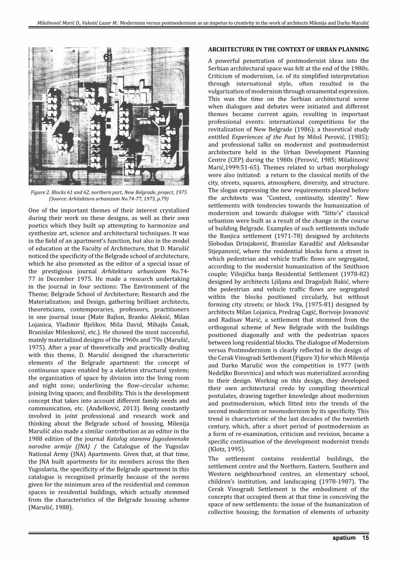
Their determination for developing residential architecture arose naturally out of the circumstances in their professional work. In the sixties, seventies and early eighties of the twentieth century, competitions were mainly announced for residential complexes, residential blocks in New Belgrade and for satellite settlements. Between ten and several thousand apartments were built in Belgrade per year (Kulić, 2002: 15, 27; Mecanov, 2009: 113-140). Their first prize won at an internal competition for blocks 61 and 62 (Figure 1) in New Belgrade in 1968 (together with M. Miodragović) ensured that their designs were materialized (1972-76). It was an architectural elaboration of an already developed urban concept of large and rhythmically distributed outlines as a part of the plan adopted in 1965, drawn up by municipal urban planner Josip Joško Svoboda, which limited and directed their work to some extent (Marušić, 1972: 125-133). They designed two types of step-like apartment blocks with apartments of different sizes in the spirit of Brutalism. The division into a living room and night zone, as well as a circular connection, characterized their approach to organizing the apartments known as the Belgrade apartment. The two-sided oriented two-wing building was a shift in functional design, and also one of the clearer examples of organizing two-wing buildings in Serbian multifamily housing. The couple Milenija and Darko Marušić expressed their own attitudes to urban composition and the architecture of large groups of residential buildings in their design for the northern part of blocks 61and 62 (1975, Figure 2), which was not materialized. In this design, they expressed an incompact concept of grouping and positioning the blocks, thinking about the buildings as smaller neighbourhood units, thus building an ambience with a recognizable identity. They introduced a series of guidelines directed towards the humanization of living. They actually criticised rigid modernist buildings, proposing a different morphology of residential block architecture in New Belgrade. In these designs, they affirmed and improved the organization of apartments, and they embedded the idea of the development concept that takes into account the needs of a household which change over time (Marušić, 1975: 79; Manević, 1974).
Milašinović Marić D., Vukotić Lazar M.: Modernism versus postmodernism as an impetus to creativity in the work of architects Milenija and Darko Marušić
Figure 1. Blocks 61 and 62, New Belgrade, 1972-76 (Source: The documentation of Milenija Marušić)
15spatium
One of the important themes of their interest crystalized during their work on these designs, as well as their own poetics which they built up attempting to harmonize and synthesize art, science and architectural techniques. It was in the field of an apartment’s function, but also in the model of education at the Faculty of Architecture, that D. Marušić noticed the specificity of the Belgrade school of architecture, which he also promoted as the editor of a special issue of the prestigious journal Arhitektura urbanizam No.74-77 in December 1975. He made a research undertaking in the journal in four sections: The Environment of the Theme; Belgrade School of Architecture; Research and the Materialization; and Design, gathering brilliant architects, theoreticians, contemporaries, professors, practitioners in one journal issue (Mate Bajlon, Branko Aleksić, Milan Lojanica, Vladimir Bjelikov, Miša David, Mihajlo Čanak, Branislav Milenković, etc.). He showed the most successful, mainly materialized designs of the 1960s and ’70s (Marušić, 1975). After a year of theoretically and practically dealing with this theme, D. Marušić designed the characteristic elements of the Belgrade apartment: the concept of continuous space enabled by a skeleton structural system; the organization of space by division into the living room and night zone; underlining the flow–circular scheme; joining living spaces; and flexibility. This is the development concept that takes into account different family needs and communication, etc. (Anđelković, 2013). Being constantly involved in joint professional and research work and thinking about the Belgrade school of housing, Milenija Marušić also made a similar contribution as an editor in the 1988 edition of the journal Katalog stanova Jugoslovenske narodne armije (JNA) / the Catalogue of the Yugoslav National Army (JNA) Apartments. Given that, at that time, the JNA built apartments for its members across the then Yugoslavia, the specificity of the Belgrade apartment in this catalogue is recognized primarily because of the norms given for the minimum area of the residential and common spaces in residential buildings, which actually stemmed from the characteristics of the Belgrade housing scheme (Marušić, 1988).
ARCHITECTURE IN THE CONTEXT OF URBAN PLANNING
A powerful penetration of postmodernist ideas into the Serbian architectural space was felt at the end of the 1980s. Criticism of modernism, i.e. of its simplified interpretation through international style, often resulted in the vulgarization of modernism through ornamental expression. This was the time on the Serbian architectural scene when dialogues and debates were initiated and different themes became current again, resulting in important professional events: international competitions for the revitalization of New Belgrade (1986); a theoretical study entitled Experiences of the Past by Miloš Perović, (1985); and professional talks on modernist and postmodernist architecture held in the Urban Development Planning Centre (CEP) during the 1980s (Perović, 1985; Milašinović Marić,1999:51-65). Themes related to urban morphology were also initiated: a return to the classical motifs of the city, streets, squares, atmosphere, diversity, and structure. The slogan expressing the new requirements placed before the architects was “Context, continuity, identity”. New settlements with tendencies towards the humanization of modernism and towards dialogue with “Sitte’s” classical urbanism were built as a result of the change in the course of building Belgrade. Examples of such settlements include the Banjica settlement (1971-78) designed by architects Slobodan Drinjaković, Branislav Karadžić and Aleksandar Stjepanović, where the residential blocks form a street in which pedestrian and vehicle traffic flows are segregated, according to the modernist humanization of the Smithson couple; Višnjička banja Residential Settlement (1978-82) designed by architects Ljiljana and Dragoljub Bakić, where the pedestrian and vehicle traffic flows are segregated within the blocks positioned circularly, but without forming city streets; or block 19a, (1975-81) designed by architects Milan Lojanica, Predrag Cagić, Borivoje Jovanović and Radisav Marić, a settlement that stemmed from the orthogonal scheme of New Belgrade with the buildings positioned diagonally and with the pedestrian spaces between long residential blocks. The dialogue of Modernism versus Postmodernism is clearly reflected in the design of the Cerak Vinogradi Settlement (Figure 3) for which Milenija and Darko Marušić won the competition in 1977 (with Nedeljko Borovnica) and which was materialized according to their design. Working on this design, they developed their own architectural credo by compiling theoretical postulates, drawing together knowledge about modernism and postmodernism, which fitted into the trends of the second modernism or neomodernism by its specificity. This trend is characteristic of the last decades of the twentieth century, which, after a short period of postmodernism as a form of re-examination, criticism and revision, became a specific continuation of the development modernist trends (Klotz, 1995). The settlement contains residential buildings, the settlement centre and the Northern, Eastern, Southern and Western neighbourhood centres, an elementary school, children’s institution, and landscaping (1978-1987). The Cerak Vinogradi Settlement is the embodiment of the concepts that occupied them at that time in conceiving the space of new settlements: the issue of the humanization of collective housing; the formation of elements of urbanity
Milašinović Marić D., Vukotić Lazar M.: Modernism versus postmodernism as an impetus to creativity in the work of architects Milenija and Darko Marušić
Figure 2. Blocks 61 and 62, northern part, New Belgrade, project, 1975 (Source: Arhitektura urbanizam No.74-77, 1975, p.79)
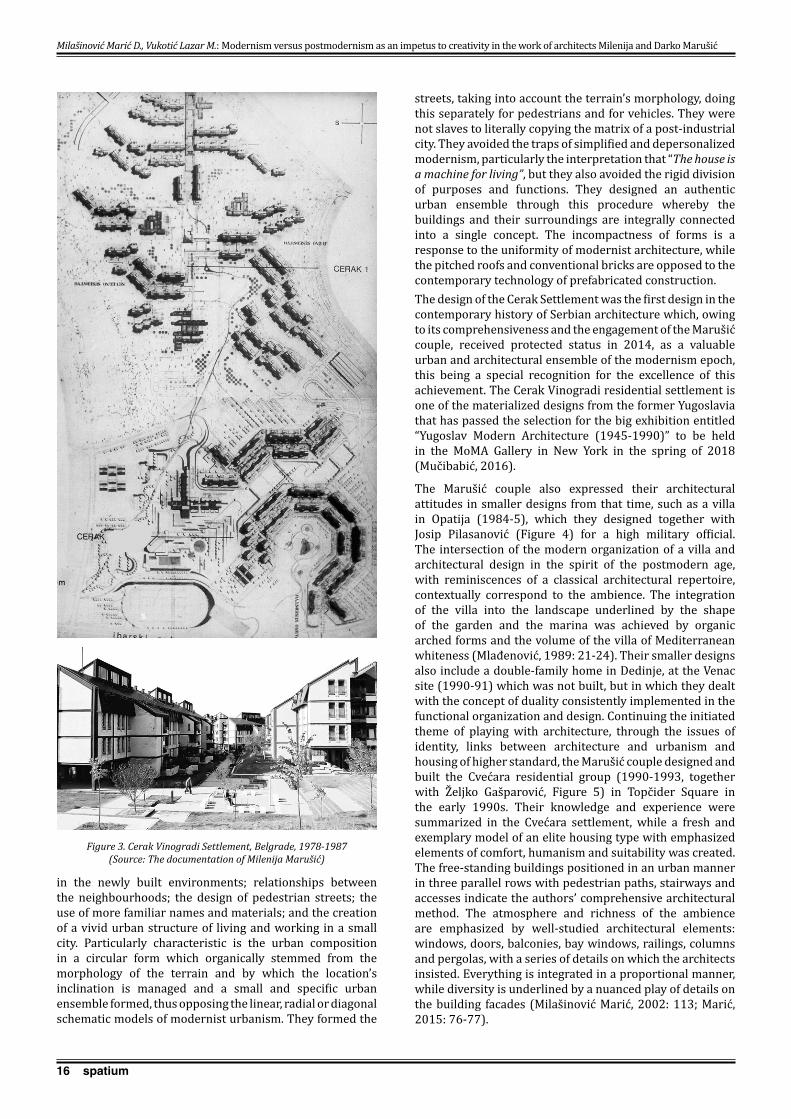
16 spatium
in the newly built environments; relationships between the neighbourhoods; the design of pedestrian streets; the use of more familiar names and materials; and the creation of a vivid urban structure of living and working in a small city. Particularly characteristic is the urban composition in a circular form which organically stemmed from the morphology of the terrain and by which the location’s inclination is managed and a small and specific urban ensemble formed, thus opposing the linear, radial or diagonal schematic models of modernist urbanism. They formed the
streets, taking into account the terrain’s morphology, doing this separately for pedestrians and for vehicles. They were not slaves to literally copying the matrix of a post-industrial city. They avoided the traps of simplified and depersonalized modernism, particularly the interpretation that “The house is a machine for living”, but they also avoided the rigid division of purposes and functions. They designed an authentic urban ensemble through this procedure whereby the buildings and their surroundings are integrally connected into a single concept. The incompactness of forms is a response to the uniformity of modernist architecture, while the pitched roofs and conventional bricks are opposed to the contemporary technology of prefabricated construction. The design of the Cerak Settlement was the first design in the contemporary history of Serbian architecture which, owing to its comprehensiveness and the engagement of the Marušić couple, received protected status in 2014, as a valuable urban and architectural ensemble of the modernism epoch, this being a special recognition for the excellence of this achievement. The Cerak Vinogradi residential settlement is one of the materialized designs from the former Yugoslavia that has passed the selection for the big exhibition entitled “Yugoslav Modern Architecture (1945-1990)” to be held in the MoMA Gallery in New York in the spring of 2018 (Mučibabić, 2016).
The Marušić couple also expressed their architectural attitudes in smaller designs from that time, such as a villa in Opatija (1984-5), which they designed together with Josip Pilasanović (Figure 4) for a high military official. The intersection of the modern organization of a villa and architectural design in the spirit of the postmodern age, with reminiscences of a classical architectural repertoire, contextually correspond to the ambience. The integration of the villa into the landscape underlined by the shape of the garden and the marina was achieved by organic arched forms and the volume of the villa of Mediterranean whiteness (Mlađenović, 1989: 21-24). Their smaller designs also include a double-family home in Dedinje, at the Venac site (1990-91) which was not built, but in which they dealt with the concept of duality consistently implemented in the functional organization and design. Continuing the initiated theme of playing with architecture, through the issues of identity, links between architecture and urbanism and housing of higher standard, the Marušić couple designed and built the Cvećara residential group (1990-1993, together with Željko Gašparović, Figure 5) in Topčider Square in the early 1990s. Their knowledge and experience were summarized in the Cvećara settlement, while a fresh and exemplary model of an elite housing type with emphasized elements of comfort, humanism and suitability was created. The free-standing buildings positioned in an urban manner in three parallel rows with pedestrian paths, stairways and accesses indicate the authors’ comprehensive architectural method. The atmosphere and richness of the ambience are emphasized by well-studied architectural elements: windows, doors, balconies, bay windows, railings, columns and pergolas, with a series of details on which the architects insisted. Everything is integrated in a proportional manner, while diversity is underlined by a nuanced play of details on the building facades (Milašinović Marić, 2002: 113; Marić, 2015: 76-77).
Milašinović Marić D., Vukotić Lazar M.: Modernism versus postmodernism as an impetus to creativity in the work of architects Milenija and Darko Marušić
Figure 3. Cerak Vinogradi Settlement, Belgrade, 1978-1987 (Source: The documentation of Milenija Marušić)
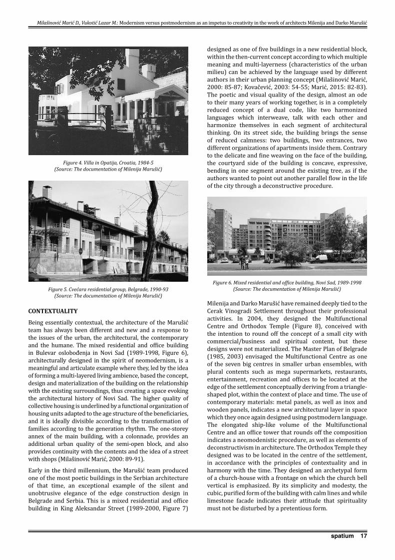
17spatium
CONTEXTUALITY
Being essentially contextual, the architecture of the Marušić team has always been different and new and a response to the issues of the urban, the architectural, the contemporary and the humane. The mixed residential and office building in Bulevar oslobođenja in Novi Sad (1989-1998, Figure 6), architecturally designed in the spirit of neomodernism, is a meaningful and articulate example where they, led by the idea of forming a multi-layered living ambience, based the concept, design and materialization of the building on the relationship with the existing surroundings, thus creating a space evoking the architectural history of Novi Sad. The higher quality of collective housing is underlined by a functional organization of housing units adapted to the age structure of the beneficiaries, and it is ideally divisible according to the transformation of families according to the generation rhythm. The one-storey annex of the main building, with a colonnade, provides an additional urban quality of the semi-open block, and also provides continuity with the contents and the idea of a street with shops (Milašinović Marić, 2000: 89-91).
Early in the third millennium, the Marušić team produced one of the most poetic buildings in the Serbian architecture of that time, an exceptional example of the silent and unobtrusive elegance of the edge construction design in Belgrade and Serbia. This is a mixed residential and office building in King Aleksandar Street (1989-2000, Figure 7)
designed as one of five buildings in a new residential block, within the then-current concept according to which multiple meaning and multi-layerness (characteristics of the urban milieu) can be achieved by the language used by different authors in their urban planning concept (Milašinović Marić, 2000: 85-87; Kovačević, 2003: 54-55; Marić, 2015: 82-83). The poetic and visual quality of the design, almost an ode to their many years of working together, is in a completely reduced concept of a dual code, like two harmonized languages which interweave, talk with each other and harmonize themselves in each segment of architectural thinking. On its street side, the building brings the sense of reduced calmness: two buildings, two entrances, two different organizations of apartments inside them. Contrary to the delicate and fine weaving on the face of the building, the courtyard side of the building is concave, expressive, bending in one segment around the existing tree, as if the authors wanted to point out another parallel flow in the life of the city through a deconstructive procedure.
Milenija and Darko Marušić have remained deeply tied to the Cerak Vinogradi Settlement throughout their professional activities. In 2004, they designed the Multifunctional Centre and Orthodox Temple (Figure 8), conceived with the intention to round off the concept of a small city with commercial/business and spiritual content, but these designs were not materialized. The Master Plan of Belgrade (1985, 2003) envisaged the Multifunctional Centre as one of the seven big centres in smaller urban ensembles, with plural contents such as mega supermarkets, restaurants, entertainment, recreation and offices to be located at the edge of the settlement conceptually deriving from a triangle-shaped plot, within the context of place and time. The use of contemporary materials: metal panels, as well as inox and wooden panels, indicates a new architectural layer in space which they once again designed using postmodern language. The elongated ship-like volume of the Multifunctional Centre and an office tower that rounds off the composition indicates a neomodenistic procedure, as well as elements of deconstructivism in architecture. The Orthodox Temple they designed was to be located in the centre of the settlement, in accordance with the principles of contextuality and in harmony with the time. They designed an archetypal form of a church-house with a frontage on which the church bell vertical is emphasized. By its simplicity and modesty, the cubic, purified form of the building with calm lines and while limestone facade indicates their attitude that spirituality must not be disturbed by a pretentious form.
Milašinović Marić D., Vukotić Lazar M.: Modernism versus postmodernism as an impetus to creativity in the work of architects Milenija and Darko Marušić
Figure 4. Villa in Opatija, Croatia, 1984-5 (Source: The documentation of Milenija Marušić)
Figure 5. Cvećara residential group, Belgrade, 1990-93 (Source: The documentation of Milenija Marušić)
Figure 6. Mixed residential and office building, Novi Sad, 1989-1998 (Source: The documentation of Milenija Marušić)

18 spatium
Architects Milenija and Darko Marušić had a unique opportunity to deal with public buildings in their design for the Metals Bank in Novi Sad (1999-2007, Figure 9). This exceptional building is an embodiment of their architectural credo recognized in: the expression of contextuality, and logic in the architectural and urban structure; duality between two panels interwoven into a harmonious ensemble; dialogue between modernism and postmodernism; the care for precision and detail; aesthetic and artistic considerations based on knowledge and the communicativeness and openness of the architectural form; as well as recognized
in a fully implemented architectural idea. The contextuality of the Metals Bank is expressed in a volumetric, almost sculptural form with two wings in stone panels that wrap the tender glass body of the building in a dialogue between the modern and traditional urban settings. The archness, movement and expressiveness of the building carries the observer, whether looking at it from the outer side of the building or experiencing it from the inside, into the world of artistic experience of space, thus confirming the thesis about architecture as an artistic discipline (Kovačević, 2007: 21). Architecture as an imprint of place in time is the initial and has remained the final idea of this building (Milašinović Marić, 2007:11).
The “Blue Bird” kindergarten (2009-2011, Figure 10) in the Cerak Vinogradi Settlement, the last in the series of built buildings designed by the Marušić couple, is particularly binding and stimulating in a symbolic and specific way. The site of the kindergarten as a visual and essential development point of the settlement ensemble is a result of a concept inspired by the Swedish proverb which says that “a child is taught by other children, the teacher and the professor”. Dealing with these three teachers of a child growing up, the Marušić couple designed a kindergarten composed of two segments with an interconnection, a playground and a skating rink organized around the existing olive tree as the central point. The courtyard was conceived to encourage children to play and be in contact with nature, with active interaction as a part of a comprehensive architectural concept. For them, the theme was challenging, but there was much enjoyment in designing a space for children. The contextuality, and plurality as a stimulating dialogue and an open communication with the beneficiaries – children, are the components of architecture stemming from everything the architects couple had done previously, but they were expressed in a completely different, fresh and original consonance between the two authors (Marušić, 2012: 81-91).
Figure 7. Mixed residential and office building, Belgrade, 1989-2000 (Source: The documentation of Milenija Marušić)
Figure 8. Multifunctional Centre, Orthodox Temple, Belgrade, projects, 2004 (Source: The documentation of Milenija Marušić)
Milašinović Marić D., Vukotić Lazar M.: Modernism versus postmodernism as an impetus to creativity in the work of architects Milenija and Darko Marušić
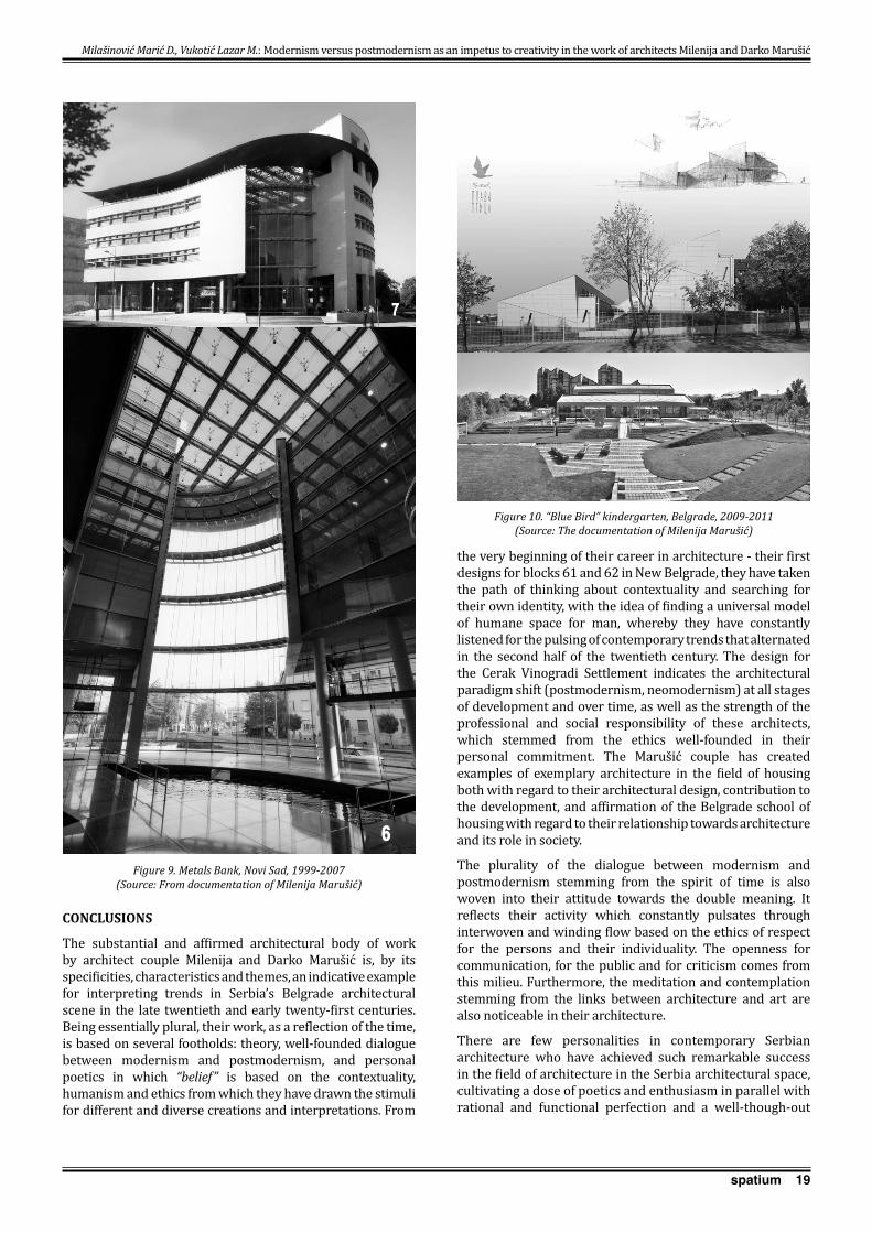
19spatium
CONCLUSIONS
The substantial and affirmed architectural body of work by architect couple Milenija and Darko Marušić is, by its specificities, characteristics and themes, an indicative example for interpreting trends in Serbia’s Belgrade architectural scene in the late twentieth and early twenty-first centuries. Being essentially plural, their work, as a reflection of the time, is based on several footholds: theory, well-founded dialogue between modernism and postmodernism, and personal poetics in which “belief” is based on the contextuality, humanism and ethics from which they have drawn the stimuli for different and diverse creations and interpretations. From
the very beginning of their career in architecture - their first designs for blocks 61 and 62 in New Belgrade, they have taken the path of thinking about contextuality and searching for their own identity, with the idea of finding a universal model of humane space for man, whereby they have constantly listened for the pulsing of contemporary trends that alternated in the second half of the twentieth century. The design for the Cerak Vinogradi Settlement indicates the architectural paradigm shift (postmodernism, neomodernism) at all stages of development and over time, as well as the strength of the professional and social responsibility of these architects, which stemmed from the ethics well-founded in their personal commitment. The Marušić couple has created examples of exemplary architecture in the field of housing both with regard to their architectural design, contribution to the development, and affirmation of the Belgrade school of housing with regard to their relationship towards architecture and its role in society.
The plurality of the dialogue between modernism and postmodernism stemming from the spirit of time is also woven into their attitude towards the double meaning. It reflects their activity which constantly pulsates through interwoven and winding flow based on the ethics of respect for the persons and their individuality. The openness for communication, for the public and for criticism comes from this milieu. Furthermore, the meditation and contemplation stemming from the links between architecture and art are also noticeable in their architecture.
There are few personalities in contemporary Serbian architecture who have achieved such remarkable success in the field of architecture in the Serbia architectural space, cultivating a dose of poetics and enthusiasm in parallel with rational and functional perfection and a well-though-out
Figure 9. Metals Bank, Novi Sad, 1999-2007 (Source: From documentation of Milenija Marušić)
Figure 10. “Blue Bird” kindergarten, Belgrade, 2009-2011 (Source: The documentation of Milenija Marušić)
Milašinović Marić D., Vukotić Lazar M.: Modernism versus postmodernism as an impetus to creativity in the work of architects Milenija and Darko Marušić
20 spatium
concept. They have created their works between two poles: the modern and the traditional; and the modernist function versus the surroundings postmodernistically harmonized with man. Milenija and Darko Marušić have always been different, original, relentlessly consistent and in love with architecture. Their activities confirm the thesis that modern architecture and urbanism in their questioning, re-examination and contestation have no alternative because the modern architectural and urban structures, like modern art, music and theatre, are reflections of our time in which proper models and answers have to be found.
REFERENCES
Anđelković, G. (2013) U duhu kontekstualizma-stanovanje i istraživanje, intervju D. i M. Marušić, www.designed.rs/blog/goran_andelkovic/u_duhu_kontekstualizma, accessed 20th Mar 2017 [Anđelković, G. (2013) In the spirit of contextualism – housing and research, interview with D. and M. Marušić/, www.designed.rs/blog/goran_andelkovic/u_duhu_kontekstualizma, accessed 20th Mar 2017.]
Bogunović, S. (2005) Arhitektonska enciklopedija Beograda XIX i XX veka, II. Arhitekti. Beograd: Beogradska knjiga, pp. 954-957. [Bogunović, S. (2005) The Encyclopaedia of Belgrade Architecture of the 19th and 20th Century, II Architects. Belgrade: Beogradska knjiga, pp. 954-957.]
Frampton, K. (2004) Modern Architecture: A Critical History, Belgrade: Orion Art.
Janakova Grujić, M. (2010) Arhitekta Milorad Macura, 1914-1989, Beograd: Centar VAM, IAUS. [Janakova Grujić, M. (2010) Architect Milorad Macura, 1914-1989, Belgrade: VAM Centre, IAUS.]
Jencks, C. (1985) The Language of Post-modern Architecture. Belgrade: Vuk Karadžić.
Jencks, C. (2007) The New Paradigm in Architecture. Belgrade: Orion art.
Klotz, H. (1995) Art in the Twentieth Century, Modernism-Postmodernism-Second Modernism. Novi Sad: Svetovi.
Kovačević, B. (2003) Nepokretni praznik, Kvadart, No. 18, pp. 54-55. [Kovačević, B. (2003) The Immoveable Holiday, Kvadart, No.18, pp. 54-55.]
Kovačević, B. (2007) Brankovina kod Banovine, in: Milašinović Marić, D. (2007) Bank in Novi Sad, Arhitektura i urbanizam No. 20/21, p. 21. [Kovačević, B. (2007) Brankovina near Banovina, in: Milašinović Marić, D. (2007) Bank in Novi Sad, Arhitektura i urbanizam No. 20/21, p. 21.]
Kulić, V. (2002) Izgradnja Beograda u periodu socijalizma 1945-2000, in: Kovenc Vujić, A. (ed.) 50 Belgrade architects, Beograd: Akademska misao, 15–27. [Kulić, V. (2002) Development of Belgrade in the period of socialism 1945-2000, in: Kovenc Vujić, A. (ed.) 50 Belgrade architects, Belgrade: Akademska misao, 15–27.]
Manević, Z. (1974) Savršena forma, IT Novine, published 18th Oct 1974. [Manević, Z. (1974) Perfect Form, IT Novine, published 18th Oct 1974.]
Manević, Z. (ed.) (2008) Leksikon neimara, Encyclopaedia architectonica, Beograd: Građevinska knjiga, pp. 392-393. [Manević, Z. (ed.) (2008) Lexicon of Architects, Encyclopaedia architectonica, Belgrade: Građevinska knjiga, pp. 392-393.]
Marić, I. (ed.), (2015) 60 godina Instituta za arhitekturu i urbanizam Srbije 1954‒2014, Beograd: IAUS. [Marić, I. (ed.), (2015) The 60th Anniversary of the Institute of Architecture and Urban & Spatial Planning of Serbia 1954-2014, Belgrade: IAUS.]
Marušić, D. (1972) Blokovi 61 i 62 u Novom Beogradu, Izgradnja, posebno izdanje, pp. 125-133. [Marušić, D. (1972) Blocks 61 and 62 in New Belgrade, Izgradnja, special edition, pp. 125-133.]
Marušić, D. (ed.) (1975) Arhitektura urbanizam, No. 74-77.Marušić, M. (ed.) (1988) Katalog stanova JNA 2. Beograd:
Savezni sekretarijat za narodnu odbranu. [Marušić, M. (ed.) (1988) Catalogue of the JNA Apartments 2. Belgrade: Federal Secretariat for National Defence.]
Marušić, M., Marušić, D., Kovačević, B. (2012) Vrtić “Plava ptica” Arhitektura i urbanizam, No. 34, pp. 81-91. [Marušić. M. Marušić, D. Kovačević, B. ( 2012) ”Blue Bird” Kindergarten, Arhitektura i urbanizam, No.34, pp. 81-91.]
Mecanov, D. (2009) Arhitektonski konkursi na Novom Beogradu od 1947. do 70-ih godina XX veka, Nasleđe, No. X, Zavod za zaštitu spomenika kulture grada Beograda, pp. 113-140. [Mecanov, D. (2009) Architectural competitions in New Belgrade from 1947 until 1970s, Nasleđe, No. X, Institute for the Protection of Cultural Monuments of Belgrade, pp. 113-140.]
Milašinović Marić, D. (1999) Beogradska arhitektura poslednjih decenija dvadesetog veka, Arhitektura i urbanizam, No. 6, pp. 51-65. [Milašinović Marić, D. (1999) Belgrade Architecture in the last decades of the twentieth century, Arhitektura i urbanizam, No. 6, pp. 51-65.]
Milašinović Marić, D. (2000) Višeslojna nostalgija, Arhitektura i urbanizam, No. 7, pp. 89-91. [Milašinović Marić, D. (2000) The Multi-layered Nostalgia, Arhitektura i urbanizam, No. 7, pp. 89-91.]
Milašinović Marić, D. (2000) Sazvučje raznolikosti, Arhitektura i urbanizam No. 7, pp. 85-88. [Milašinović Marić, D. (2000) Diversity Consonance, Arhitektura i urbanizam, No. 7, pp. 85-88.]
Milašinović Marić, D. (2002) Vodič kroz modernu arhitekturu Beograda. Beograd: Društvo arhitekata Beograda. [Milašinović Marić, D. (2002) Guide to modern architecture in Belgrade. Belgrade: Association of Belgrade Architects.]
Milašinović Marić, D. (2007) Banka u Novom Sadu, Arhitektura i urbanizam No. 20/21, pp. 7-24. [Milašinović Marić, D. (2007) Bank in Novi Sad, Arhitektura i urbanizam, No. 20/21, pp. 7-24.]
Milašinović Marić, D. (2010) Portreti arhitekata, retrospektiva članova Arhitektonske sekcije ULUPUDS-a 1953-2010, Beograd: Vizuelno, p. 150. [Milašinović Marić, D. (2010) Portraits of Architects, a Retrospective of the Members of the ULUPUDS Section for Architecture, Belgrade: Vizuelno, p. 150.]
Mitrović, M. (2012) Arhitektura Beograda 1950-2012, Beograd: Službeni glasnik. [Mitrović, M. (2012) Belgrade Architecture 1950-2012, Belgrade: Službeni glasnik.]
Mlađenović, I. (1989) 11 istaknutih arhitekata Jugoslavije, Vol. 3, Beograd: Studio Linija 3. [Mlađenović, I. (1989) 11 prominent Yugoslav architects, Vol. 3, Belgrade: Studio Linija 3.]
Mučibabić, D. (2016) Cerak vinogradi - naselje kao kulturno dobro, Politika, published 7th Jan 2016. [Mučibabić, D. (2016), Cerak Vinogradi – the settlement as a cultural property, Politika, published 7th Jan 2016.]
Milašinović Marić D., Vukotić Lazar M.: Modernism versus postmodernism as an impetus to creativity in the work of architects Milenija and Darko Marušić

21spatium
Perović, R. M. (1985) Iskustva prošlosti. Beograd: Zavod za planiranje razvoja grada Beograda. [Perović, R. M. (1985) Experiences of the Past, Belgrade: Institute for Planning the Development of the City of Belgrade.]
Perović, R. M. (2003) Srpska arhitektura XX veka, Od istoricizma do drugog modenizma. Beograd: Arhitektonski fakultet, Univerziteta u Beogradu. [Perović, R. M. (2003) Serbian 20th century architecture. From historicism to second modernism. Belgrade: Faculty of Architecture, University of Belgrade.]
Šuvaković, M. (1995) Postmoderna (73 pojma). Beograd: Narodna knjiga, Alfa. [Šuvaković, M. (1995) Postmodernism (73 concepts). Belgrade: Narodna knjiga, Alfa.]
Milašinović Marić D., Vukotić Lazar M.: Modernism versus postmodernism as an impetus to creativity in the work of architects Milenija and Darko Marušić
Received April 2017; accepted in revised form June 2017.
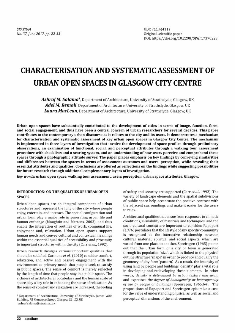
22 spatium
INTRODUCTION: ON THE QUALITIES OF URBAN OPEN SPACES
Urban open spaces are an integral component of urban structures and represent the lung of the city where people enjoy, entertain, and interact. The spatial configuration and urban form play a major role in generating urban life and human exchange (Moughtin and Mertens, 2003), and thus enable the integration of routines of work, communal life, enjoyment and, relaxation. Urban open spaces support human needs and convey cultural and contextual meanings within the essential qualities of accessibility and proximity to important structures within the city (Carr et al., 1992).
Urban research divulges various important qualities that should be satisfied. Carmona et al., (2010) consider comfort, relaxation, and active and passive engagement with the environment as primary needs that people seek to satisfy in public spaces. The sense of comfort is merely reflected by the length of time that people stay in a public space. The richness of architectural vocabulary and the human scale of space play a key role in enhancing the sense of relaxation. As the sense of comfort and relaxation are increased, the feeling
of safety and security are supported (Carr et al., 1992). The variety of landscape elements and the spatial subdivisions of public space help accentuate the positive contrast with the adjacent surroundings and make it easier for the users to relax.
Architectural qualities that ensue from responses to climatic conditions, availability of materials and techniques, and the socio-cultural context are important to consider. Rapoport (1976) postulates that the lifestyle of any specific community is recognised as the interactive relationship between cultural, material, spiritual and social aspects, which are varied from one place to another. Spreiregen (1965) points out that the urban form of a city or town is generated through its population ‘size’, which is linked to the physical outline structure ‘shape’, in order to produce and qualify the geometry of city form ‘pattern’. As a result, the intensity of using land by people and buildings ‘density’ play a vital role in developing and redeveloping these elements. In other words, density is determined by urban texture and grain and expresses the degree of homogeneity or heterogeneity of use by people or buildings (Spreiregen, 1965:64). The propositions of Rapoport and Spreiregen epitomize a case for the value of understanding physical as well as social and perceptual dimensions of the environment.
CHARACTERISATION AND SYSTEMATIC ASSESSMENT OF URBAN OPEN SPACES IN GLASGOW CITY CENTRE
Ashraf M. Salama1, Department of Architecture, University of Strathclyde, Glasgow, UKAdel M. Remali, Department of Architecture, University of Strathclyde, Glasgow, UKLaura MacLean, Department of Architecture, University of Strathclyde, Glasgow, UK
Urban open spaces have substantially contributed to the development of cities in terms of image, function, form, and social engagement, and thus have been a central concern of urban researchers for several decades. This paper contributes to the contemporary urban discourse as it relates to the city and its users. It demonstrates a mechanism for characterisation and systematic assessment of key urban open spaces in Glasgow City Centre. The mechanism is implemented in three layers of investigation that involve the development of space profiles through preliminary observations, an examination of functional, social, and perceptual attributes through a walking tour assessment procedure with checklists and a scoring system, and an understanding of how users perceive and comprehend these spaces through a photographic attitude survey. The paper places emphasis on key findings by conveying similarities and differences between the spaces in terms of assessment outcomes and users’ perception, while revealing their essential attributes and qualities. Conclusions are offered as reflections on the findings while suggesting possibilities for future research through additional complementary layers of investigation.Key words: urban open space, walking tour assessment, users perception, urban space attributes, Glasgow.
1 Department of Architecture, University of Strathclyde, James Weir Building, 75 Montrose Street, Glasgow G1 1XJ, UK [email protected]
UDC 711.4(411)Original scientific paperDOI: https://doi.org/10.2298/SPAT1737022S
SPATIUM No. 37, June 2017, pp. 22-33

23spatium
The sense of ‘individuality within collectiveness’ is another important quality that satisfies needs of users and is typically enabled by a clear distinctiveness of an urban space, which facilitates diversity of perceptions and emotional responses (Salama and Gharib, 2012). Conspicuously, clear boundaries and appropriate proportions of built forms that consider human scale are critical factors for maintaining this quality. In essence, social activities that take place in an urban open space mandate an understanding of how people perceive it and the way in which they comprehend the significance of its visual and aesthetic qualities (Moughtin and Mertens, 2003). A general agreement in the literature corroborates that a vibrant city is a matter of the density of pedestrian movement, quality of public spaces, and diversity of uses (Buchanan, 1963; Barnett, 1983; Schumacher, 1986; Jacobs, 1993).
The preceding discussion suggests that studying how the urban spaces are used continues to be pivotal in interpreting the relationship between users and their surroundings. Therefore, this paper addresses the significance and methods of obtaining information on the experience, use, and perception by demonstrating a mechanism for characterisation and systematic assessment of nine urban open spaces in Glasgow City Centre. Methodologically, the mechanism is implemented in three layers of investigation that involve the development of space profiles through preliminary observations, an examination of functional, social and perceptual attributes through a walking tour assessment procedure with checklists and a scoring system, and an understanding of how users perceive and comprehend these spaces through a photographic attitude survey. Such a mechanism enables a profound insight into the understanding of the essential characteristics of urban open spaces.
THE CONTEXT OF THE STUDY: GLASGOW CITY CENTRE
The City Centre of Glasgow can be understood within three main stages of development: The Medieval City, the Merchant City, and Blythswood. The medieval stage began in the 12th century with the centre fully established by the 16th century (McKean et al., 1989). The only remaining edifice is the medieval Cathedral that has prime importance to the city (Williamson et al., 1990). The second stage was the planned ‘New Town’ known as the ‘Merchant City’, which commenced in 1786. This stage brought wide gridiron streets that contrasted the spontaneous medieval settlement pattern. The third stage was Blythswood in 1830 and displayed clear gridiron streets and squares, which were an expansion of the Merchant City.
While discussing the detailed urban evolution of Glasgow City Centre goes beyond the scope of this study, it should be noted that during the 19th century the city was known as the ‘second city of the British Empire’. During this time Glasgow witnessed rapid growth in terms of population and urban expansion (McKean et al., 1989). This period was characterised by magnificent Victorian buildings and urban spaces, which continue to shape the character of modern Glasgow. Conversely, during the 1930s, the prosperity of the city declined dramatically where, for decades, the city was portrayed as an unsafe city, with rumours of razor
gangs’ itinerant through the streets (Stewart, 1997). In recent years Glasgow has initiated to its new role as a post-industrial European city and has become a vibrant hub for trade, education, culture, and arts. Despite urban sprawl, social segregation, and car dependency (Frey, 1999) the city displays a great deal of spatial and formal consistency, which makes it a thought-provoking place for urban exploration.
A MECHANISM FOR CHARACTERISATION AND ASSESSMENT OF URBAN OPEN SPACES
Nine urban open spaces are selected to examine their qualities. The selection is based on a combination of squares and streets (Figure 1). The urban squares include George Square, which represents the civic heart of the city, whereas Royal Exchange Square and St. Enoch Square are considered the most important spaces within Merchant City. The Royal Exchange Square accommodates Gallery of Modern Art, GOMA. Included in the study is St. Andrews Square, which is regarded as the first pre-planned square along the initial street (High Street). Additionally, the Central Bus Station Square is a vital urban place that links one of the most active areas in the city (Central Bus Station) with the surrounding urban context. While selecting urban streets such as Argyle Street, Sauchiehall Street and Buchanan Galleries is due to their location along the city’s ‘Golden Z’, the Clyde Street is included in the study based on its position that represents an interface between the edge of the centre and the River Clyde (Figures 1 & 2). The mechanism for characterisation and assessment involves three layers of investigation as discussed hereunder.
Development of Space Profiles
The first layer includes the development of space profiles or portfolios for each of the selected spaces based on preliminary observations. As a procedure, it encompasses categorization of spaces in terms of spatial typology, architectural patterns, accessibility, activities and use, and user types. Each category incorporates a number of parameters that enable effective classification.
A Walking Tour Assessment Procedure
Following earlier scholarly explorations conducted in other contexts (Salama and Azzali, 2015), the second layer of
Salama A.M. et al.: Characterisation and systematic assessment of urban open spaces in Glasgow City Centre
Figure 1. The location of the nine selected urban open spaces in Glasgow City Centre
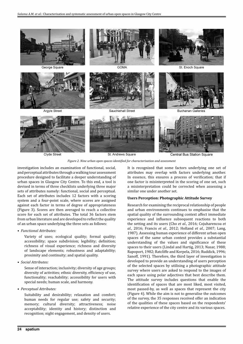
24 spatium
investigation includes an examination of functional, social, and perceptual attributes through a walking tour assessment procedure designed to facilitate a deeper understanding of urban spaces in Glasgow City Centre. To this end, a tool is devised in terms of three checklists underlying three major sets of attributes namely: functional, social and perceptual. Each set of attributes includes 12 factors with a scoring system and a four-point scale, where scores are assigned against each factor in terms of degree of appropriateness (Figure 3). Scores are then averaged to reach a collective score for each set of attributes. The total 36 factors stem from urban literature and are developed to reflect the quality of an urban space underlying the three sets as follows:
• Functional Attributes: Variety of uses; ecological quality; formal quality; accessibility; space subdivision; legibility; definition; richness of visual experience; richness and diversity of landscape elements; robustness and adaptability; proximity and continuity; and spatial quality.
• Social Attributes: Sense of interaction; inclusivity; diversity of age groups; diversity of activities; ethnic diversity, efficiency of use, functionality; reachability; accessibility for users with special needs; human scale, and harmony.
• Perceptual Attributes: Suitability and desirability; relaxation and comfort; human needs for regular use; safety and security; memory; cultural diversity; attractiveness; noise acceptability; identity and history; distinction and recognition; night engagement, and density of users.
It is recognized that some factors underlying one set of attributes may overlap with factors underlying another. In essence, this ensures a process of verification; that if one factor is misinterpreted in the scoring of one set, such a misinterpretation could be corrected when assessing a similar one under another set.
Users Perception: Photographic Attitude Survey
Research for examining the reciprocal relationship of people and urban environments continues to emphasise that the spatial quality of the surrounding context affect immediate experience and influence subsequent reactions to both the setting and its users (Cho et al., 2016; Cojuharencoa et al., 2016; Francis et al., 2012; Holland et al., 2007; Lang, 1987). Assessing human experience of different urban open spaces of the same urban context provides a substantial understanding of the values and significance of these spaces to their users (Lindal and Hartig, 2013; Nasar, 1988; Rapoport, 1982; Ratcliffe and Korpela, 2016; Ruddick, 1996; Sanoff, 1991). Therefore, the third layer of investigation is developed to provide an understanding of users perception of the selected spaces by utilising a photographic attitude survey where users are asked to respond to the images of each space using polar adjectives that best describe them. The attitude survey includes questions that enable the identification of spaces that are most liked, most visited, most passed-by, as well as spaces that represent the city (Figure 4). While the aim is not to generalise the outcomes of the survey, the 35 responses received offer an indication of the qualities of these spaces based on the respondents’ relative experience of the city centre and its various spaces.
Salama A.M. et al.: Characterisation and systematic assessment of urban open spaces in Glasgow City Centre
Figure 2. Nine urban open spaces identified for characterisation and assessment
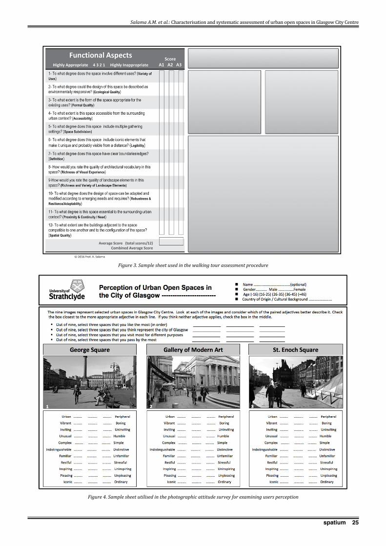
25spatium
Salama A.M. et al.: Characterisation and systematic assessment of urban open spaces in Glasgow City Centre
Figure 3. Sample sheet used in the walking tour assessment procedure
Figure 4. Sample sheet utilised in the photographic attitude survey for examining users perception
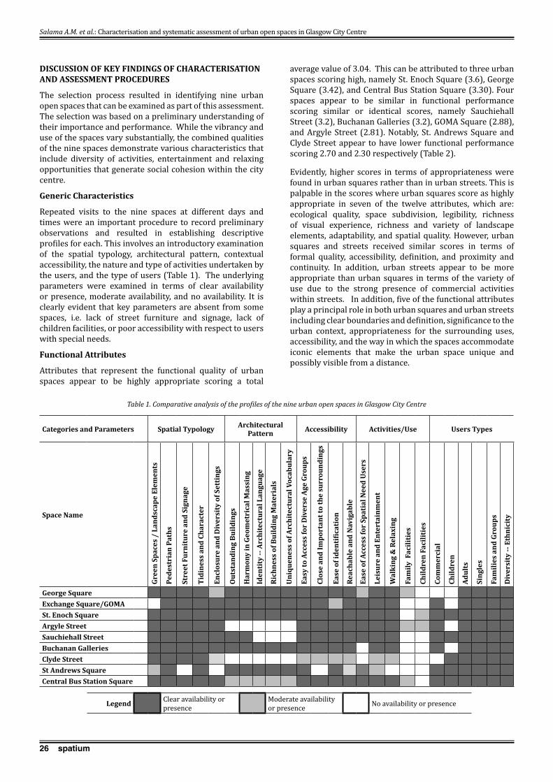
26 spatium
DISCUSSION OF kEY FINDINGS OF CHARACTERISATION AND ASSESSMENT PROCEDURES
The selection process resulted in identifying nine urban open spaces that can be examined as part of this assessment. The selection was based on a preliminary understanding of their importance and performance. While the vibrancy and use of the spaces vary substantially, the combined qualities of the nine spaces demonstrate various characteristics that include diversity of activities, entertainment and relaxing opportunities that generate social cohesion within the city centre.
Generic Characteristics
Repeated visits to the nine spaces at different days and times were an important procedure to record preliminary observations and resulted in establishing descriptive profiles for each. This involves an introductory examination of the spatial typology, architectural pattern, contextual accessibility, the nature and type of activities undertaken by the users, and the type of users (Table 1). The underlying parameters were examined in terms of clear availability or presence, moderate availability, and no availability. It is clearly evident that key parameters are absent from some spaces, i.e. lack of street furniture and signage, lack of children facilities, or poor accessibility with respect to users with special needs.
Functional Attributes
Attributes that represent the functional quality of urban spaces appear to be highly appropriate scoring a total
average value of 3.04. This can be attributed to three urban spaces scoring high, namely St. Enoch Square (3.6), George Square (3.42), and Central Bus Station Square (3.30). Four spaces appear to be similar in functional performance scoring similar or identical scores, namely Sauchiehall Street (3.2), Buchanan Galleries (3.2), GOMA Square (2.88), and Argyle Street (2.81). Notably, St. Andrews Square and Clyde Street appear to have lower functional performance scoring 2.70 and 2.30 respectively (Table 2).
Evidently, higher scores in terms of appropriateness were found in urban squares rather than in urban streets. This is palpable in the scores where urban squares score as highly appropriate in seven of the twelve attributes, which are: ecological quality, space subdivision, legibility, richness of visual experience, richness and variety of landscape elements, adaptability, and spatial quality. However, urban squares and streets received similar scores in terms of formal quality, accessibility, definition, and proximity and continuity. In addition, urban streets appear to be more appropriate than urban squares in terms of the variety of use due to the strong presence of commercial activities within streets. In addition, five of the functional attributes play a principal role in both urban squares and urban streets including clear boundaries and definition, significance to the urban context, appropriateness for the surrounding uses, accessibility, and the way in which the spaces accommodate iconic elements that make the urban space unique and possibly visible from a distance.
Salama A.M. et al.: Characterisation and systematic assessment of urban open spaces in Glasgow City Centre
Categories and Parameters Spatial Typology Architectural Pattern Accessibility Activities/Use Users Types
Space Name
Gree
n Sp
aces
/ L
ands
cape
Ele
men
ts
Pede
stri
an P
aths
Stre
et F
urni
ture
and
Sig
nage
Tidi
ness
and
Cha
ract
er
Encl
osur
e an
d D
iver
sity
of S
etti
ngs
Out
stan
ding
Bui
ldin
gs
Har
mon
y in
Geo
met
rica
l Mas
sing
Iden
tity
-- A
rchi
tect
ural
Lan
guag
e
Rich
ness
of B
uild
ing
Mat
eria
ls
Uni
quen
ess
of A
rchi
tect
ural
Voc
abul
ary
Easy
to A
cces
s fo
r D
iver
se A
ge G
roup
s
Clos
e an
d Im
port
ant t
o th
e su
rrou
ndin
gs
Ease
of i
dent
ifica
tion
Reac
habl
e an
d N
avig
able
Ease
of A
cces
s fo
r Sp
atia
l Nee
d U
sers
Leis
ure
and
Ente
rtai
nmen
t
Wal
king
& R
elax
ing
Fam
ily F
acili
ties
Child
ren
Faci
litie
s
Com
mer
cial
Child
ren
Adul
ts
Sing
les
Fam
ilies
and
Gro
ups
Div
ersi
ty --
Eth
nici
ty
George Square Exchange Square/GOMA St. Enoch Square Argyle Street Sauchiehall Street Buchanan Galleries Clyde Street St Andrews Square Central Bus Station Square
Legend Clear availability or presence
Moderate availability or presence No availability or presence
Table 1. Comparative analysis of the profiles of the nine urban open spaces in Glasgow City Centre

27spatium
When making comparison two urban spaces that have similar physical form and historical structures such as St. Andrews Square and GOMA Square the assessment procedure discloses interesting results. Although the former achieved high scores in eight of the functional attributes and the latter achieved high scores only in four of the twelve attributes, the assessment scores of St. Andrews Square is only 2.70 and of GOMA Square is 2.81. Palpably, GOMA Square is vibrant in terms of city life while no urban life exists in St. Andrews Square. This demonstrates that functional attributes such as the variety of uses, accessibility, space subdivision, and proximity and continuity, contribute the most in attracting people and in increasing the usability of urban spaces (Figure 5).
Sauchiehall, Argyle and Buchanan Streets form an essential part of the city centre of Glasgow, the city’s Golden Z, where most of the pedestrian activities take place. The city life is robustly generated by the diversity of functions along pedestrianized pathways, which also provide a suave accessibility, valuable spatial quality, and richness of visual experience. Likewise, it is clear that GOMA and George Squares enjoy proximity to the city’s Golden Z,
accommodating a high level of daily vibrancy, irrespective of rather limited diversity of uses. This provides evidence that formal quality, space subdivision, legibility, definition and adaptability are important attributes that characterise the two spaces and are substantial factors that enhance city life.
Social Attributes
The assessment of social attributes reveals that urban spaces combined appear to be highly appropriate scoring a total average score of 3.07 (Table 3). Principally, this stem from the qualities of four urban spaces, scoring as highly appropriate: Sauchiehall Street (3.73), St. Enoch Square (3.5), Central Bus Station Square (3.50), and Argyle Street (3.29). George Square, Buchanan Galleries, and GOMA Square scored relatively high: 3.04, 3.19, and 3.08 respectively. However, the total average scores were fairly lower for Clyde Street (2.15) and St. Andrews Square (2.13).
Primarily, urban streets and urban squares are appropriate for social interaction within the city centre of Glasgow though urban streets maintain relatively higher scores over urban squares in terms of functionality, sense of interaction, and human scale. Urban streets and squares are reachable
Salama A.M. et al.: Characterisation and systematic assessment of urban open spaces in Glasgow City Centre
Functional Attributes
Vari
ety
of U
ses
Ecol
ogic
al Q
ualit
y
Form
al Q
ualit
y
Acce
ssib
ility
Spac
e Su
bdiv
isio
n
Legi
bilit
y
Def
init
ion
Rich
ness
of V
isua
l Ex
peri
ence
Rich
ness
& v
arie
ty o
f La
ndsc
ape
elem
ents
obus
tnes
s &
Res
ilien
ce/
Adap
tabi
lity
Prox
imit
y &
Con
tinu
ity/
N
eed
Spat
ial Q
ualit
y
Tota
l Ave
rage
/spa
ce
George Square 2.00 3.75 3.50 2.75 3.00 3.75 3.75 3.75 3.25 4.00 4.00 3.50 3.42Exchange Square/GOMA 3.00 1.25 3.00 3.25 3.25 3.00 3.75 3.00 2.00 2.50 3.50 3.00 2.88St. Enoch Square 4.00 3.25 3.75 4.00 3.50 3.75 3.75 3.50 3.50 3.50 3.75 3.75 3.60Argyle Street 3.50 1.50 3.50 4.00 2.50 1.25 3.75 1.50 2.50 3.00 4.00 2.75 2.81Sauchiehall Street 4.00 3.25 4.00 4.00 3.00 2.00 3.25 2.75 3.00 3.00 4.00 2.50 3.20Buchanan Galleries 3.75 2.25 3.25 3.25 3.50 3.50 3.00 3.25 2.75 3.00 3.75 3.25 3.20Clyde Street 1.25 2.50 2.75 2.25 2.25 3.00 3.00 2.00 2.75 2.00 2.00 2.00 2.30St Andrews Square 1.00 3.00 3.25 2.25 2.25 3.50 4.00 3.25 2.25 3.00 1.50 3.25 2.70Central Bus Station Square 3.75 3.00 3.00 3.50 3.75 3.75 3.25 3.25 3.00 3.00 3.25 3.00 3.30Overall Assessment 2.92 2.64 3.33 3.25 3.00 3.05 3.50 2.92 2.78 3.00 3.31 3.00 3.04
≤ 1.00 (Highly Inappropriate) ˃ 1.00 – 2.00 (Inappropriate) ˃ 2.00 – 3.00 (Appropriate) ˃ 3.00 Highly Appropriate
Table 2. Outcomes of assessing the functional attributes of the selected urban open spaces
Figure 5. Diversity of land use and city life in similar urban form and historical structures
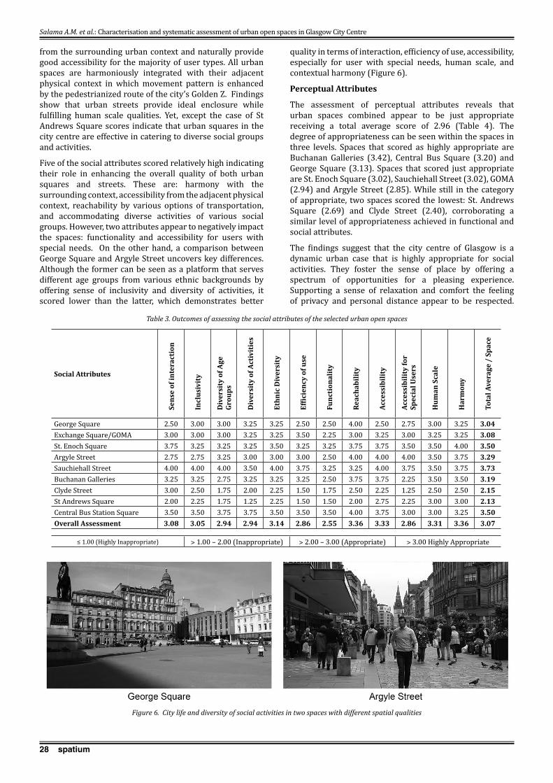
28 spatium
from the surrounding urban context and naturally provide good accessibility for the majority of user types. All urban spaces are harmoniously integrated with their adjacent physical context in which movement pattern is enhanced by the pedestrianized route of the city’s Golden Z. Findings show that urban streets provide ideal enclosure while fulfilling human scale qualities. Yet, except the case of St Andrews Square scores indicate that urban squares in the city centre are effective in catering to diverse social groups and activities.
Five of the social attributes scored relatively high indicating their role in enhancing the overall quality of both urban squares and streets. These are: harmony with the surrounding context, accessibility from the adjacent physical context, reachability by various options of transportation, and accommodating diverse activities of various social groups. However, two attributes appear to negatively impact the spaces: functionality and accessibility for users with special needs. On the other hand, a comparison between George Square and Argyle Street uncovers key differences. Although the former can be seen as a platform that serves different age groups from various ethnic backgrounds by offering sense of inclusivity and diversity of activities, it scored lower than the latter, which demonstrates better
quality in terms of interaction, efficiency of use, accessibility, especially for user with special needs, human scale, and contextual harmony (Figure 6).
Perceptual Attributes
The assessment of perceptual attributes reveals that urban spaces combined appear to be just appropriate receiving a total average score of 2.96 (Table 4). The degree of appropriateness can be seen within the spaces in three levels. Spaces that scored as highly appropriate are Buchanan Galleries (3.42), Central Bus Square (3.20) and George Square (3.13). Spaces that scored just appropriate are St. Enoch Square (3.02), Sauchiehall Street (3.02), GOMA (2.94) and Argyle Street (2.85). While still in the category of appropriate, two spaces scored the lowest: St. Andrews Square (2.69) and Clyde Street (2.40), corroborating a similar level of appropriateness achieved in functional and social attributes.
The findings suggest that the city centre of Glasgow is a dynamic urban case that is highly appropriate for social activities. They foster the sense of place by offering a spectrum of opportunities for a pleasing experience. Supporting a sense of relaxation and comfort the feeling of privacy and personal distance appear to be respected.
Salama A.M. et al.: Characterisation and systematic assessment of urban open spaces in Glasgow City Centre
Figure 6. City life and diversity of social activities in two spaces with different spatial qualities
Table 3. Outcomes of assessing the social attributes of the selected urban open spaces
Social Attributes
Sens
e of
inte
ract
ion
Incl
usiv
ity
Div
ersi
ty o
f Age
Gr
oups
Div
ersi
ty o
f Act
ivit
ies
Ethn
ic D
iver
sity
Effic
ienc
y of
use
Func
tion
alit
y
Reac
habi
lity
Acce
ssib
ility
Acce
ssib
ility
for
Spec
ial U
sers
Hum
an S
cale
Har
mon
y
Tota
l Ave
rage
/ S
pace
George Square 2.50 3.00 3.00 3.25 3.25 2.50 2.50 4.00 2.50 2.75 3.00 3.25 3.04Exchange Square/GOMA 3.00 3.00 3.00 3.25 3.25 3.50 2.25 3.00 3.25 3.00 3.25 3.25 3.08St. Enoch Square 3.75 3.25 3.25 3.25 3.50 3.25 3.25 3.75 3.75 3.50 3.50 4.00 3.50Argyle Street 2.75 2.75 3.25 3.00 3.00 3.00 2.50 4.00 4.00 4.00 3.50 3.75 3.29Sauchiehall Street 4.00 4.00 4.00 3.50 4.00 3.75 3.25 3.25 4.00 3.75 3.50 3.75 3.73Buchanan Galleries 3.25 3.25 2.75 3.25 3.25 3.25 2.50 3.75 3.75 2.25 3.50 3.50 3.19Clyde Street 3.00 2.50 1.75 2.00 2.25 1.50 1.75 2.50 2.25 1.25 2.50 2.50 2.15St Andrews Square 2.00 2.25 1.75 1.25 2.25 1.50 1.50 2.00 2.75 2.25 3.00 3.00 2.13Central Bus Station Square 3.50 3.50 3.75 3.75 3.50 3.50 3.50 4.00 3.75 3.00 3.00 3.25 3.50Overall Assessment 3.08 3.05 2.94 2.94 3.14 2.86 2.55 3.36 3.33 2.86 3.31 3.36 3.07
≤ 1.00 (Highly Inappropriate) ˃ 1.00 – 2.00 (Inappropriate) ˃ 2.00 – 3.00 (Appropriate) ˃ 3.00 Highly Appropriate

29spatium
Additionally, the results reveal that urban squares provide a memorable and attractive architectural character that enables an effective spatial experience. Yet, urban streets score higher than urban squares in the sense that they are able to sustain the feeling of vibrancy while accommodating an array of uses and thus diverse activities.
In essence, the perceptual attributes can be divided into two levels. The first is essential in generating the city life, which includes suitability and desirability, relaxation and comfort, human needs, safety and security, cultural diversity, acceptability, night engagement and density of users. The second level involves memory, attractiveness, identity and history, and distinction and recognition, which can be regarded as secondary perceptual factors that have an indirect impact on the social activities within Glasgow City Centre. Still, this level of factors generates good quality for urban squares while enriching them as public places with vibrant social activities.
DISCUSSION OF kEY FINDINGS OF THE PHOTOGRAPHIC ATTITUDE SURVEY
Based on responses received from 35 users the analysis of the photographic attitude survey portrays the way in which they perceive and comprehend the nine selected urban open spaces as they relate to their experience of Glasgow City Centre.
Experience-based Users Perception
George Square is considered to be Glasgow’s ‘Grande’ Place where 71% of the respondents consider it as most representative of the city while 43% view it as the most liked space. Despite that only 25% regularly visit and pass-by the square, this appears to be still higher than other spaces (Figure 7). This can be attributed to the square as a community space that fulfils a multitude of functions within the heart of the city, accommodating different events and functions including civic functions, seasonal commercial fairs, large events such as the city Hogmanay celebrations, the Winter Wonderland, and occasionally host pipe bands.
Salama A.M. et al.: Characterisation and systematic assessment of urban open spaces in Glasgow City Centre
Perceptual Attributes
Suita
bilit
y an
d
Desi
rabi
lity
Rela
xatio
n an
d Co
mfo
rt
Hum
an N
eeds
Safe
ty &
Sec
urity
Mem
ory
Cultu
ral D
iver
sity
Attr
activ
enes
s
Acce
ptab
ility
Iden
tity
& H
isto
ry
Dist
inct
ion
/
Reco
gniti
on
Nig
ht E
ngag
emen
t
Dens
ity o
f Use
rs
Tota
l Ave
rage
/
Spac
e
George Square 3.25 3.00 2.75 3.00 3.75 2.50 3.50 2.75 3.50 3.50 3.00 3.00 3.13Exchange Square/GOMA 3.00 3.25 3.25 2.50 3.50 2.00 2.75 3.75 3.25 3.25 2.00 2.75 2.94St. Enoch Square 3.25 3.50 3.00 3.00 3.25 2.75 3.00 3.00 3.25 3.25 2.50 3.00 3.02Argyle Street 3.25 3.25 3.50 3.00 2.25 2.25 3.00 2.75 2.00 3.25 2.00 3.75 2.85Sauchiehall Street 3.25 3.50 4.00 3.50 2.00 3.00 3.00 3.00 2.00 3.50 2.00 3.50 3.02Buchanan Galleries 3.50 3.75 3.25 3.50 3.75 3.00 3.25 2.75 3.75 3.75 3.25 3.50 3.42Clyde Street 2.75 3.00 2.75 2.00 1.75 2.25 2.75 2.75 2.50 2.75 1.50 2.00 2.40St Andrews Square 2.00 2.50 2.50 2.50 3.00 1.50 3.50 3.75 3.25 3.25 2.50 2.00 2.69Central Bus Station Square 3.00 3.00 3.25 3.25 3.75 3.00 3.25 2.00 3.50 3.50 3.00 3.75 3.20Overall Assessment 3.03 3.19 3.14 3.92 3.00 2.47 3.11 2.94 3.00 3.33 2.42 3.03 2.96
≤ 1.00 (Highly Inappropriate) ˃ 1.00 – 2.00 (Inappropriate) ˃ 2.00 – 3.00 (Appropriate) ˃ 3.00 Highly Appropriate
Table 4. Outcomes of assessing the perceptual attributes of the selected urban open spaces
Figure 7. Users description of the spaces as they relate to the city and to their experience
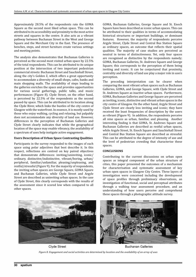
30 spatium
Approximately 28.5% of the respondents rate the GOMA Square as the second most liked urban space. This can be attributed to its accessibility and proximity to the most active streets and squares in the centre. It also acts as a vibrant pathway between Buchanan Street in the West and George Square and the Merchant City in the East. The presence of benches, steps, and street furniture create various settings and meeting points.
The analysis also demonstrates that Buchanan Galleries is perceived as the second most visited urban space by 22.5% of the total respondents. This can be attributed to its unique position at the intersection of two important pedestrian commercial streets: Buchanan Street and Sauchiehall Street, along the city’s Golden Z, which offers a great opportunity to accommodate a diversity of small shops, cafes, banks and main shopping malls. The availability of steps leading to the galleries enriches the space and provides opportunities for various social gatherings, public talks, and music performances (Figure 8). Clyde Street, on the other hand, is perceived by 22.5% of the respondents as the second passed-by space. This can be attributed to its location along the Clyde River, which links the bustles of the city centre of Glasgow with the waterfront. In essence, it is mostly used by those who enjoy walking, cycling and relaxing, but palpably does not accommodate any diversity of land use. However, differences in the perception of Buchanan Galleries and Clyde Street clearly indicates that while the geographical location of the space may enable vibrancy, the availability of a spectrum of uses help instigate active engagement.
Users Description of Urban Space Contrasting Qualities
Participants in the survey responded to the images of each space using polar adjectives that best describe it. In this respect, reflections are centred on key paired objectives that demonstrate differences: inviting/uninviting, iconic/ordinary, distinctive/indistinctive, vibrant/boring, urban/peripheral, familiar/unfamiliar, pleasing/unpleasing, and restful/stressful (Figure 9). For the majority of respondents, the inviting urban spaces are George Square, GOMA Square and Buchanan Galleries, while Clyde Street and Argyle Street are described as uninviting urban spaces. In the case of Clyde Street, this clearly corresponds with the results of the assessment since it scored low when compared to all other spaces.
GOMA, Buchanan Galleries, George Square and St. Enoch Square have been described as iconic urban spaces. This can be attributed to their qualities in terms of accommodating historical structures or important buildings, or dominant features. However, the majority of respondents perceive Argyle Street, Clyde Street and Central Bus Station Square as ordinary spaces, an outcome that reflects their spatial qualities. The majority of case studies are perceived as neutral in terms of distinctiveness. Yet, only four spaces are recognised as distinctive by the respondents namely; GOMA, Buchanan Galleries, St. Andrews Square and George Square; this corresponds to the perception of them being inviting and iconic. It can be conjectured that proximity, centrality and diversity of land use play a major role in users perception. The preceding interpretation can be clearer when comparing the most vibrant urban spaces such as Buchanan Galleries, GOMA, and George Square, with Clyde Street and St. Andrews Square as inactive urban spaces. Furthermore, GOMA, Buchanan Galleries and George Square are perceived as inviting, iconic, distinctive and vibrant urban spaces in the city centre of Glasgow. On the other hand, Argyle Street and Clyde Street are clearly less inviting and iconic; they have received the least frequencies of description by the users as vibrant (Figure 9). In addition, the respondents perceive all nine spaces as urban, familiar, and pleasing. Another interesting finding is that GOMA, St. Andrews Square and Buchanan Galleries are described as restful urban spaces, while Argyle Street, St. Enoch Square and Sauchiehall Street and Central Bus Station Square are described as stressful. This can be attributed to the degree of intensity of use and the level of pedestrian crowding that characterise these spaces.
CONCLUSIONS
Contributing to the current discussions on urban open spaces as integral component of the urban structure of cities, this paper presented the outcomes of a mechanism for characterisation and systematic assessment of key urban open spaces in Glasgow City Centre. Three layers of investigation were conceived including the development of space profiles through preliminary observations, an investigation of functional, social and perceptual attributes through a walking tour assessment procedure, and an understanding of how users perceive and comprehend these spaces through a photographic attitude survey.
Figure 8. Engagement and social activities are determined by location and the availability of an array of uses
Salama A.M. et al.: Characterisation and systematic assessment of urban open spaces in Glasgow City Centre
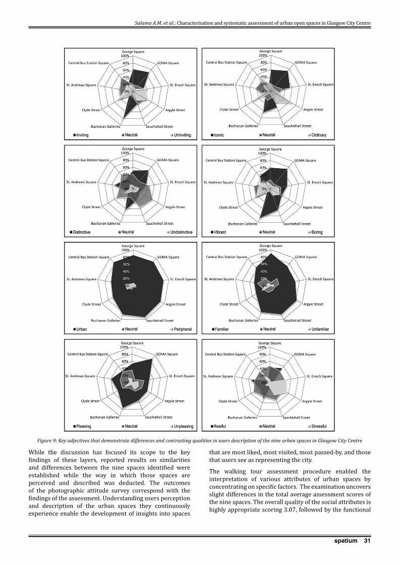
31spatium
While the discussion has focused its scope to the key findings of these layers, reported results on similarities and differences between the nine spaces identified were established while the way in which those spaces are perceived and described was deducted. The outcomes of the photographic attitude survey correspond with the findings of the assessment. Understanding users perception and description of the urban spaces they continuously experience enable the development of insights into spaces
that are most liked, most visited, most passed-by, and those that users see as representing the city.
The walking tour assessment procedure enabled the interpretation of various attributes of urban spaces by concentrating on specific factors. The examination uncovers slight differences in the total average assessment scores of the nine spaces. The overall quality of the social attributes is highly appropriate scoring 3.07, followed by the functional
Figure 9: Key adjectives that demonstrate differences and contrasting qualities in users description of the nine urban spaces in Glasgow City Centre
Salama A.M. et al.: Characterisation and systematic assessment of urban open spaces in Glasgow City Centre
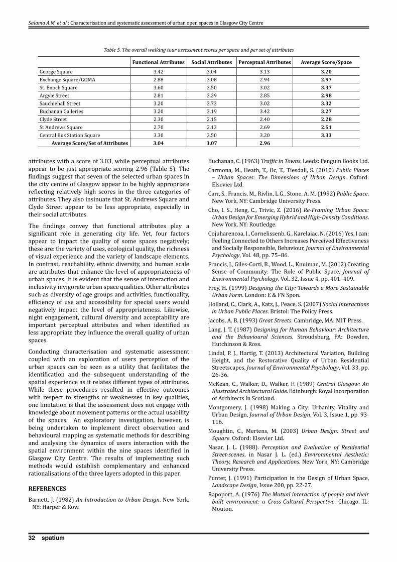
32 spatium
attributes with a score of 3.03, while perceptual attributes appear to be just appropriate scoring 2.96 (Table 5). The findings suggest that seven of the selected urban spaces in the city centre of Glasgow appear to be highly appropriate reflecting relatively high scores in the three categories of attributes. They also insinuate that St. Andrews Square and Clyde Street appear to be less appropriate, especially in their social attributes.
The findings convey that functional attributes play a significant role in generating city life. Yet, four factors appear to impact the quality of some spaces negatively; these are: the variety of uses, ecological quality, the richness of visual experience and the variety of landscape elements. In contrast, reachability, ethnic diversity, and human scale are attributes that enhance the level of appropriateness of urban spaces. It is evident that the sense of interaction and inclusivity invigorate urban space qualities. Other attributes such as diversity of age groups and activities, functionality, efficiency of use and accessibility for special users would negatively impact the level of appropriateness. Likewise, night engagement, cultural diversity and acceptability are important perceptual attributes and when identified as less appropriate they influence the overall quality of urban spaces.
Conducting characterisation and systematic assessment coupled with an exploration of users perception of the urban spaces can be seen as a utility that facilitates the identification and the subsequent understanding of the spatial experience as it relates different types of attributes. While these procedures resulted in effective outcomes with respect to strengths or weaknesses in key qualities, one limitation is that the assessment does not engage with knowledge about movement patterns or the actual usability of the spaces. An exploratory investigation, however, is being undertaken to implement direct observation and behavioural mapping as systematic methods for describing and analysing the dynamics of users interaction with the spatial environment within the nine spaces identified in Glasgow City Centre. The results of implementing such methods would establish complementary and enhanced rationalisations of the three layers adopted in this paper.
REFERENCES
Barnett, J. (1982) An Introduction to Urban Design. New York, NY: Harper & Row.
Buchanan, C. (1963) Traffic in Towns. Leeds: Penguin Books Ltd.Carmona, M., Heath, T., Oc, T., Tiesdall, S. (2010) Public Places
– Urban Spaces: The Dimensions of Urban Design. Oxford: Elsevier Ltd.
Carr, S., Francis, M., Rivlin, L.G., Stone, A. M. (1992) Public Space. New York, NY: Cambridge University Press.
Cho, I. S., Heng, C., Trivic, Z. (2016) Re-Framing Urban Space: Urban Design for Emerging Hybrid and High-Density Conditions. New York, NY: Routledge.
Cojuharencoa, I., Cornelissenb, G., Karelaiac, N. (2016) Yes, I can: Feeling Connected to Others Increases Perceived Effectiveness and Socially Responsible, Behaviour, Journal of Environmental Psychology, Vol. 48, pp. 75–86.
Francis, J., Giles-Corti, B., Wood, L., Knuiman, M. (2012) Creating Sense of Community: The Role of Public Space, Journal of Environmental Psychology, Vol. 32, Issue 4, pp. 401–409.
Frey, H. (1999) Designing the City: Towards a More Sustainable Urban Form. London: E & FN Spon.
Holland, C., Clark, A., Katz, J., Peace, S. (2007) Social Interactions in Urban Public Places. Bristol: The Policy Press.
Jacobs, A. B. (1993) Great Streets. Cambridge, MA: MIT Press.Lang, J. T. (1987) Designing for Human Behaviour: Architecture
and the Behavioural Sciences. Stroudsburg, PA: Dowden, Hutchinson & Ross.
Lindal, P. J., Hartig, T. (2013) Architectural Variation, Building Height, and the Restorative Quality of Urban Residential Streetscapes, Journal of Environmental Psychology, Vol. 33, pp. 26-36.
McKean, C., Walker, D., Walker, F. (1989) Central Glasgow: An Illustrated Architectural Guide. Edinburgh: Royal Incorporation of Architects in Scotland.
Montgomery, J. (1998) Making a City: Urbanity, Vitality and Urban Design, Journal of Urban Design, Vol. 3, Issue 1, pp. 93-116.
Moughtin, C., Mertens, M. (2003) Urban Design: Street and Square. Oxford: Elsevier Ltd.
Nasar, J. L. (1988). Perception and Evaluation of Residential Street-scenes, in Nasar J. L. (ed.) Environmental Aesthetic: Theory, Research and Applications. New York, NY: Cambridge University Press.
Punter, J. (1991) Participation in the Design of Urban Space, Landscape Design, Issue 200, pp. 22-27.
Rapoport, A. (1976) The Mutual interaction of people and their built environment: a Cross-Cultural Perspective. Chicago, IL: Mouton.
Functional Attributes Social Attributes Perceptual Attributes Average Score/Space
George Square 3.42 3.04 3.13 3.20Exchange Square/GOMA 2.88 3.08 2.94 2.97St. Enoch Square 3.60 3.50 3.02 3.37Argyle Street 2.81 3.29 2.85 2.98Sauchiehall Street 3.20 3.73 3.02 3.32Buchanan Galleries 3.20 3.19 3.42 3.27Clyde Street 2.30 2.15 2.40 2.28St Andrews Square 2.70 2.13 2.69 2.51Central Bus Station Square 3.30 3.50 3.20 3.33
Average Score/Set of Attributes 3.04 3.07 2.96
Table 5. The overall walking tour assessment scores per space and per set of attributes
Salama A.M. et al.: Characterisation and systematic assessment of urban open spaces in Glasgow City Centre

33spatium
Ratcliffe, E., Korpela, K. M. (2016) Memory and Place Attachment as Predictors of Imagined Restorative Perceptions of Favourite Places, Journal of Environmental Psychology, Vol. 48, pp. 120–130.
Ruddick, S. (1996) Constructing Difference in Public Spaces: Race, Class, and Gender as Interlocking Systems, Urban Geography, Vol. 17, Issue 2, pp. 132-151.
Salama, A. M., Gharib, R. Y. (2012) A Perceptual Approach for Investigating Urban Space Diversity in the City of Doha, Open House International, Vol. 37, Issue 2, pp. 24-32.
Salama, A. M., Azzali, S. (2015) Examining Attributes of Urban Open Spaces in Doha. Proceedings of the ICE - Urban Design and Planning, Vol. 168, Issue 2, pp. 75–87.
Sanoff, H. (1991) Visual Research Methods in Design. New York, NY: Van Nostrand Rienhold.
Schumacher, T. (1986). Buildings and Streets: Notes on Configuration and Use, in Anderson, S. (ed.) On Streets, Cambridge, MA: MIT Press.
Spreiregen, P. (1965) Urban Design: The Architecture of Towns and Cities. New York, NY: McGraw-Hill.
Stewart, P. (1997) Central Glasgow. Gloucestershire: Tempus Publishing.
Webber, P. (1988) The Design of Sydney: Three Decades of Change in the City Centre. Sydney: Law Book.
Williamson, E., Riches, A., Malcolm, H. (1990) Glasgow: The Buildings of Scotland. London: Penguin Books.
Received May 2017; accepted in revised form June 2017.
Salama A.M. et al.: Characterisation and systematic assessment of urban open spaces in Glasgow City Centre

34 spatium
INTRODUCTION
Rapid urbanization has been a key feature of spatial development in all parts of the world throughout the 20th century, albeit with some discrepancies between highly developed and developing countries. Worldwide, urban growth has increasingly been dominated by trends of suburbanization and sprawl, particularly in the last decades. Europe, including Southeast Europe (SEE), has been no exception to this trend. Urban development in the SEE region has been influenced by a particular set of historical, socio-economic and political conditions. While many of the above-mentioned trends have been observed in SEE as well, the prevailing forms of urbanization in the region have yet to be thoroughly investigated. Thus, the aim of this paper is to examine the dynamics behind urbanization in SEE and
the similarities and differences in the trends, specifically with regard to the unique changes that have occurred in the socio-economic and political environment in the region.
As contemporary trends associated with urbanization are most evident in the largest cities, the capital cities of Belgrade and Sofia are relevant case-studies. Some of the key aspects characterizing urban development in SEE cities can be attributed to the experience of the socialist period. In this regard, three periods of urban development can be distinguished: the transition to socialism, the socialist period and the transition from socialism to a post-socialist system. This paper focuses primarily on the third period; however, it also examines specific features of the socialist period, so as to distinguish between each period’s distinct impact on urban development. For the present study, an important aspect of urban development is the interplay between planning and the market. For our work, the market
THE CHANGING ROLES OF PLANNING AND THE MARkET IN THE PROCESSES OF URBAN GROWTH
IN BELGRADE AND SOFIA
This paper studies the changing roles of planning and the market in the context of urban growth and suburbanization in the capitals of Serbia and Bulgaria, specifically with regard to the socio-economic changes experienced in Southeast Europe over the past decades. With a focus on the post-socialist period, the work also examines specific features of the socialist period, so as to make important distinctions between the two. The research question in this paper is: Is planning or the market responsible for the form of growth that has occurred in Sofia and Belgrade? One methodological problem for the study is that in reality, most urban processes are to a degree both market driven and centrally planned. Thus, it can be difficult to distinguish between the distinct roles and outcomes of planning and the market. To solve this problem, the paper analyzes situations in which either planning or the market is dominant, so as to be able to clearly determine the impact of each mechanism on the resultant development. The paper concludes that urban growth and suburbanization are generally engendered by market forces, whereas the role of planning is to improve and refine the action of the market. When planning ignores the market, it results in failed or inefficient urban forms. However when planning is absent, urban development fails to meet reasonable standards.Key words: Post-socialist development, suburbanization, urban growth, market-led urban development, market-planning relationship.
1 Chaika Resort, 9007 Varna, Bulgaria [email protected]
UDC 711.24(497.11:497.2) 338.23:330.35(497.11:497.2)Review paperDOI: https://doi.org/10.2298/SPAT1737034K
SPATIUM No. 37, June 2017, pp. 34-41
Atanas Kovachev, Bulgarian Academy of Sciences, Sofia, BulgariaAleksandar D. Slaev1, Varna Free University, Faculty of Architecture, Varna, Bulgaria
Slavka Zeković, Institute of Architecture and Urban & Spatial Planning of Serbia, Belgrade, SerbiaTamara Maričić, Institute of Architecture and Urban & Spatial Planning of Serbia, Belgrade, Serbia
Diliana Daskalova, Varna Free University, Faculty of Architecture, Varna, Bulgaria

35spatium
is considered to be the decentralized coordination of socio-economic activities. Conversely, planning is the centralized coordination (or central organization) of human socio-economic activity. Planning comprises a combination of centralized, semi-centralized, decentralized and “hybrid” approaches. The plurality of approaches of this kind has been particularly relevant in the case of the former planning system and practice in Yugoslavia (Serbia).
Suburbanization and sprawl are generally regarded as market driven urban developments, although the role of planning is also important (in Serbia for instance, sprawl has also been observed in the era of socialist planning). Contemporary compact urban growth, on the other hand, is considered to be the outcome of planning; however, this issue has not been investigated sufficiently and a unified position is lacking. Thus, the question that this research seeks to answer is: Did planning or the market play a larger role in determining the forms of growth in Sofia and Belgrade? To answer this question, the paper investigates situations in which only one type of coordination is dominant, while the other form is almost missing. Upon this basis, broad conclusions can be drawn about the impact of planning versus the market in the practice of urban development.
THE CONTEMPORARY DISCOURSE OF THE ROLE OF PLANNING AND THE MARkET IN URBAN GROWTH
First and foremost, it is important to distinguish between the meanings of “urban growth”, “suburbanization” and “sprawl”. “Urban growth” is any increase in the population of a city, town or a settlement. “Suburbanization” denotes any growth in urban activities (and the population) in peri-urban, or peripheral, areas. Modern western suburbanization commonly takes the form of urban sprawl. Sprawl is considered a specific type of suburbanization featuring low densities and scattered or ribbon patterns of development.
While suburbanization and urban sprawl can be driven both by planning and the market, suburbanization, as a rule, is the result of the decisions of decentralized players such as households and companies. The European Environment Agency (EEA) (2006) identifies the drivers of sprawl as follows: means of transportation, the price of land, individual housing preferences, demographic trends, cultural traditions and constraints, the attractiveness of existing urban areas, and, not least, the application of land use planning policies at both local and regional scales. Apparently, only two of the listed drivers are directly associated with planning: the means of transportation and the application of land use planning policies. All other factors produce their impact by means of the market. Land consumption for housing, economic activity and commercial growth, population growth, transportation and infrastructure create serious pressures in urban areas (Nuissl et al., 2009). Still, many authors emphasize the influence of planning on developments occurring in the urban fringe (Knaap, 2008; Turnbull, 2004). While land values and land-use are determined by the interaction of supply and demand (Harvey and Jowsey, 2004), different policies and instruments are designed to prevent excessive land consumption. They impact the assessment of land-use changes in urban areas and implement different types
of spatial governance for (peri-urban) territorial cohesion (Ravetz and Loibl, 2011). The European Environmental Agency (2006:7) states that “where growth around the periphery of the city is coordinated by strong urban policy, more compact forms of urban development can be secured”. However, while the impact of planning should not be denied, the view that sprawl is primarily market-driven prevails (e.g. Gong and Wheeler, 2002; Brueckner, 2000). Therefore, the initiatives taken on by decentralized market players generate sprawl and the role of planning is to respond and to regulate this process. The planning system may stimulate, facilitate, regulate and even ban the development of certain activities, thus creating the framework for suburbanization.
This conclusion emphasizes the need for planners to be actively engaged in managing the issues of suburbanization and sprawl. As Knaap (2008) notes, many urban economists tend to overlook the role of and the need for planning (Anas and Rhee, 2006; Arnott and Inci, 2006; Brueckner, 2000). Indeed, while the performance of planning may be questioned in many situations pertaining to urban development, urban expansion is a process in which the need for effective planning is most evident. Nivola (1998) draws a comparison between American and European cities to maintain that European cities, in general, follow more sustainable patterns of development. He finds that the differences in the rates of urban expansion are only partly due to different lifestyles and residential preferences. To some extent, they are also due to the very different role of planning that is implemented in managing urban development. It is not only urban planners that call for the wider use of planning instruments to combat sprawl. The remedies suggested by urban economists (e.g. Anas and Rhee, 2006; Arnott and Inci, 2006; Brueckner, 2000) are genuine tools of central governance and planning. What they usually propose are various taxes and fees like congestion tolls, property taxes, development fees, etc. Yet governance is, after all, nothing but developing and implementing plans and regulations (Slaev, 2016a, 2016c). When considering the market effect of taxes and fees, they should be viewed not as purely market tools’, but as instruments for the coordinated mediation between planning and the market (e.g. in the case of land value capture tax). The relationship between urban planning and the market can be both positive and negative (Slaev, 2016c). As Holcombe (2013:3) notes, “[s]ometimes planning is designed to counteract market forces, revealing an adversarial relationship between planning and the invisible hand [of the market]. Other times planning builds on the spontaneous order of the market, and the two will be allies.” In many cases, it is not about ‘planning-or-market’, but rather about the appropriate mix of ‘planning-and-market.’ This approach is increasingly understood as the most suitable way of addressing the management issues in urban and related development.
METHODOLOGICAL NOTES
In practice, it is very difficult to measure the roles of planning and the market in a social activity because the impacts of both mechanisms are inherently related and intertwined. For this reason it is, first of all, necessary to clearly establish which one is considered a market-driven process and which
Kovachev A. et al.: The changing roles of planning and the market in the processes of urban growth in Belgrade and Sofia

36 spatium
is planning-driven. As defined in the introduction, a social activity is considered market-driven when the actions of numerous decentralized agents are coordinated by the price mechanism; alternatively, the centralized organization of a social activity requires planning to be employed. Indeed, social activities require a special type of planning that is relevant to complex systems, termed nomocratic planning (Moroni, 2010, 2015). Many researchers regard this kind of planning as decentralized – or bottom-up (Portugali, 2008; Moroni, 2010; Holcombe, 2013). But whereas the main purpose of nomocratic planning is, indeed, to provide space for decentralized agents to participate in the management process, it is still a centralized activity (Slaev, 2016b). Therefore, a process is planning-driven if and when it is organized and conducted by a central authority, and market-driven if it is comprised of the activities and arrangements between decentralized agents (despite the significance and impact of the price mechanism not being easy to observe in some cases – e.g. in spontaneous suburban developments).
A methodological problem for this research is that in reality most processes are based on decentralized arrangements as well as governed by a central authority. Therefore, our methodological approach is to study the impact of each of these mechanisms in situations where only one is predominant. The effect on urban development can thus be clearly attributed to the predominant mechanism. Planning can be the sole or predominant mechanism of social interaction only on some occasions and in a centralized society, e.g. a socialist one. In contrast, in a market society, planning may, as a rule, act only along in conjunction with the market. It is possible that on specific occasions and for specific reasons in a market society, the market may be unfettered by centralized governance or interference. In other words, the market will be the sole or predominant mechanism of socio-economic coordination. With these considerations in mind, we proceed with a brief examination of the general characteristics of suburbanization in Sofia and Belgrade over the past few decades. Then, to answer the research question (i.e., to identify the roles of planning and the market), we analyze specific situations in which one of the two mechanisms is markedly (strongly) dominant in the urban development of the two cities.
THE INTERPLAY OF PLANNING AND THE MARkET AND ITS CONSEQUENCE FOR URBAN GROWTH IN BELGRADE AND SOFIA
The growth of Belgrade and Sofia in the 20th century
As some researchers argue (e.g. Fee and Hartley, 2011), suburbanization is often just the first phase of urban growth. The cycles of growth in cities are usually associated with expansion into the surrounding landscape. This was already the case in Belgrade and Sofia in the early decades of the 20th century (Belgrade: 1910 - 90,000, 1948 - 398,000; Sofia: 1910 - 103,000, 1946 - 530,000). The accelerated population growth in the two capital cities was the general reason for the growth of suburban areas, particularly in the late 1960s. From 1948 to 1991 Belgrade grew from 398,000 to 1,168,000 residents (by 193.5%). From 1946 to 1985 the population of Sofia grew from 530,000 to 1,202,000 residents (by 127%).
Post-war recovery and industrialization were among the major drivers of urban growth in cities across Europe. The high rate of urbanization in the socialist countries was a result of the so-called policy of accelerated socialist industrialization (Slaev and Kovachev, 2014; Zeković et al. 2015, Daskalova and Slaev, 2015). It, in turn, resulted in the emergence of socialist suburbs, which are associated with industrial methods of construction – prefab housing.
The changing roles of planning and the market in Sofia and Belgrade
As explained in the methodological section, this paper employs a specific approach to examine the roles of planning and the market underlying Sofia and Belgrade’s peri-urban development. It focuses on instances of suburban development in which one of the two alternative mechanisms of social coordination – planning or the market – is more or less isolated. This will help us to avoid the difficult discussions which arise when the results observed can be attributed to either mechanism. Former socialist countries have had a very specific experience with regard to the relationship between planning and the market. Even though during the period of socialism, planning was given an overwhelming priority, the Yugoslavian political system was proclaimed to be “market socialism.” Thus, the market held sway over the urban development of Belgrade (to a greater or lesser extent) even during the period of so-called “societal agreements”, albeit in the form of a “black” (illegal) or “grey” market (related to land development, illegal buildings, and the competitiveness between state enterprises, etc.). In Bulgaria, the stage was officially defined as the “first market phase of communism”, but markets were, in fact, heavily suppressed, especially in the areas of property development, housing and urban affairs. Only state construction enterprises could operate in the urban development sector. All housing sales and real estate dealings were executed by state agencies. Thus, it may be concluded that during this period in Bulgaria, planning was the primary mechanism for social coordination in the field of urban development and the market was largely absent.
To study the implications of this situation, it is instrumental to examine the 1961 plan of Sofia. A competition was held between two teams of planners who presented alternative proposals. One of them envisaged compact development and the other proposed considerable territorial expansion (Kovachev, 2003a). The compact variant was chosen, only to be amended three years later to resemble the expansionary plan much more closely, under the pretext of accommodating extreme population growth. Indeed, this was a real concern, as the population forecasted for 1985 – 800,000 – was reached only 5 years after the adoption of the plan. Even though there were population controls in place such as those requiring individuals to be employed in their town of residence (fixed citizenship), immigrants from the countryside still found their way into Sofia. For instance, citizenship was granted for the rapidly increasing number of occupations in the capital city.
Thus, the 1961 compact variant was abandoned and the development of mass, prefab housing estates began in the urban fringe. Eventually, these “socialist suburbs” would
Kovachev A. et al.: The changing roles of planning and the market in the processes of urban growth in Belgrade and Sofia
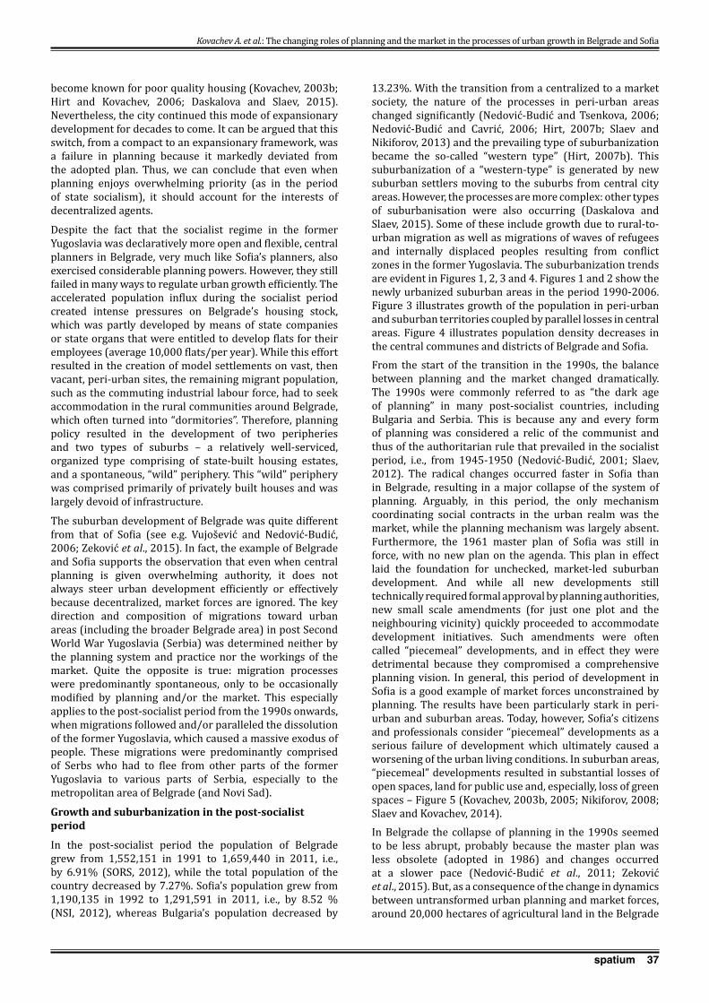
37spatium
become known for poor quality housing (Kovachev, 2003b; Hirt and Kovachev, 2006; Daskalova and Slaev, 2015). Nevertheless, the city continued this mode of expansionary development for decades to come. It can be argued that this switch, from a compact to an expansionary framework, was a failure in planning because it markedly deviated from the adopted plan. Thus, we can conclude that even when planning enjoys overwhelming priority (as in the period of state socialism), it should account for the interests of decentralized agents.
Despite the fact that the socialist regime in the former Yugoslavia was declaratively more open and flexible, central planners in Belgrade, very much like Sofia’s planners, also exercised considerable planning powers. However, they still failed in many ways to regulate urban growth efficiently. The accelerated population influx during the socialist period created intense pressures on Belgrade’s housing stock, which was partly developed by means of state companies or state organs that were entitled to develop flats for their employees (average 10,000 flats/per year). While this effort resulted in the creation of model settlements on vast, then vacant, peri-urban sites, the remaining migrant population, such as the commuting industrial labour force, had to seek accommodation in the rural communities around Belgrade, which often turned into “dormitories”. Therefore, planning policy resulted in the development of two peripheries and two types of suburbs – a relatively well-serviced, organized type comprising of state-built housing estates, and a spontaneous, “wild” periphery. This “wild” periphery was comprised primarily of privately built houses and was largely devoid of infrastructure.
The suburban development of Belgrade was quite different from that of Sofia (see e.g. Vujošević and Nedović-Budić, 2006; Zeković et al., 2015). In fact, the example of Belgrade and Sofia supports the observation that even when central planning is given overwhelming authority, it does not always steer urban development efficiently or effectively because decentralized, market forces are ignored. The key direction and composition of migrations toward urban areas (including the broader Belgrade area) in post Second World War Yugoslavia (Serbia) was determined neither by the planning system and practice nor the workings of the market. Quite the opposite is true: migration processes were predominantly spontaneous, only to be occasionally modified by planning and/or the market. This especially applies to the post-socialist period from the 1990s onwards, when migrations followed and/or paralleled the dissolution of the former Yugoslavia, which caused a massive exodus of people. These migrations were predominantly comprised of Serbs who had to flee from other parts of the former Yugoslavia to various parts of Serbia, especially to the metropolitan area of Belgrade (and Novi Sad).
Growth and suburbanization in the post-socialist period
In the post-socialist period the population of Belgrade grew from 1,552,151 in 1991 to 1,659,440 in 2011, i.e., by 6.91% (SORS, 2012), while the total population of the country decreased by 7.27%. Sofia’s population grew from 1,190,135 in 1992 to 1,291,591 in 2011, i.e., by 8.52 % (NSI, 2012), whereas Bulgaria’s population decreased by
13.23%. With the transition from a centralized to a market society, the nature of the processes in peri-urban areas changed significantly (Nedović-Budić and Tsenkova, 2006; Nedović-Budić and Cavrić, 2006; Hirt, 2007b; Slaev and Nikiforov, 2013) and the prevailing type of suburbanization became the so-called “western type” (Hirt, 2007b). This suburbanization of a “western-type” is generated by new suburban settlers moving to the suburbs from central city areas. However, the processes are more complex: other types of suburbanisation were also occurring (Daskalova and Slaev, 2015). Some of these include growth due to rural-to-urban migration as well as migrations of waves of refugees and internally displaced peoples resulting from conflict zones in the former Yugoslavia. The suburbanization trends are evident in Figures 1, 2, 3 and 4. Figures 1 and 2 show the newly urbanized suburban areas in the period 1990-2006. Figure 3 illustrates growth of the population in peri-urban and suburban territories coupled by parallel losses in central areas. Figure 4 illustrates population density decreases in the central communes and districts of Belgrade and Sofia.From the start of the transition in the 1990s, the balance between planning and the market changed dramatically. The 1990s were commonly referred to as “the dark age of planning” in many post-socialist countries, including Bulgaria and Serbia. This is because any and every form of planning was considered a relic of the communist and thus of the authoritarian rule that prevailed in the socialist period, i.e., from 1945-1950 (Nedović-Budić, 2001; Slaev, 2012). The radical changes occurred faster in Sofia than in Belgrade, resulting in a major collapse of the system of planning. Arguably, in this period, the only mechanism coordinating social contracts in the urban realm was the market, while the planning mechanism was largely absent. Furthermore, the 1961 master plan of Sofia was still in force, with no new plan on the agenda. This plan in effect laid the foundation for unchecked, market-led suburban development. And while all new developments still technically required formal approval by planning authorities, new small scale amendments (for just one plot and the neighbouring vicinity) quickly proceeded to accommodate development initiatives. Such amendments were often called “piecemeal” developments, and in effect they were detrimental because they compromised a comprehensive planning vision. In general, this period of development in Sofia is a good example of market forces unconstrained by planning. The results have been particularly stark in peri-urban and suburban areas. Today, however, Sofia’s citizens and professionals consider “piecemeal” developments as a serious failure of development which ultimately caused a worsening of the urban living conditions. In suburban areas, “piecemeal” developments resulted in substantial losses of open spaces, land for public use and, especially, loss of green spaces – Figure 5 (Kovachev, 2003b, 2005; Nikiforov, 2008; Slaev and Kovachev, 2014).In Belgrade the collapse of planning in the 1990s seemed to be less abrupt, probably because the master plan was less obsolete (adopted in 1986) and changes occurred at a slower pace (Nedović-Budić et al., 2011; Zeković et al., 2015). But, as a consequence of the change in dynamics between untransformed urban planning and market forces, around 20,000 hectares of agricultural land in the Belgrade
Kovachev A. et al.: The changing roles of planning and the market in the processes of urban growth in Belgrade and Sofia

38 spatium
Kovachev A. et al.: The changing roles of planning and the market in the processes of urban growth in Belgrade and Sofia
Figure 2. New artificial areas in the districts of the Municipality of Sofia 1990-2006 (Source: Krunić et al., 2014)
Figure 1. New artificial areas in the communes of the City of Belgrade, 1990-2000 and 2001-2006 (Source: Krunić et al., 2014)
metropolitan area were converted into construction land in the period 1980-2003 (World Bank, 2004). Parallel to that, local urban development experienced major difficulties due to the waves of war refugees from the former Yugoslav republics and internally displaced people from Kosovo and Metohija. Because of the refugees’ urgent housing needs, most of them settled in suburban areas where land was available, though typically this land was not designated for housing purposes. The planning system could not adapt quickly enough to this major influx of migrants and informal construction escalated (Figure 5). According to UNECE (2009), the informal settlements represent the prevailing
form of urban sprawl, taking up 22% of construction land and up to 40% of residential areas in the broader Belgrade area. The number of illegal buildings in the Belgrade region was about 200,000 in 2008 (Nedović-Budić et al., 2011). Clearly, this development was generated by the decisions of numerous, decentralized agents who solved their housing problems by decentralized actions. Therefore, these developments can be classified as of a market type not fundamentally different from the “piecemeal” developments in Sofia. Belgrade’s government and planning institutions, as already stressed, did not react in due time to these trends and planning was, in fact, missing.
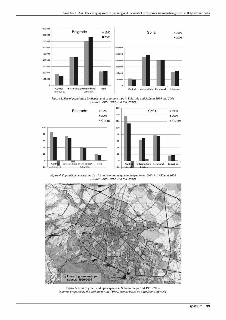
39spatium
Kovachev A. et al.: The changing roles of planning and the market in the processes of urban growth in Belgrade and Sofia
Figure 3. Size of population by district and commune type in Belgrade and Sofia in 1990 and 2006(Source: SORS, 2012, and NSI, 2012)
Figure 4. Population densities by district and commune type in Belgrade and Sofia in 1990 and 2006(Source: SORS, 2012, and NSI, 2012)
Figure 5. Loss of green and open spaces in Sofia in the period 1990-2006(Source: prepared by the authors for the TURAS project based on data from Sofproekt)
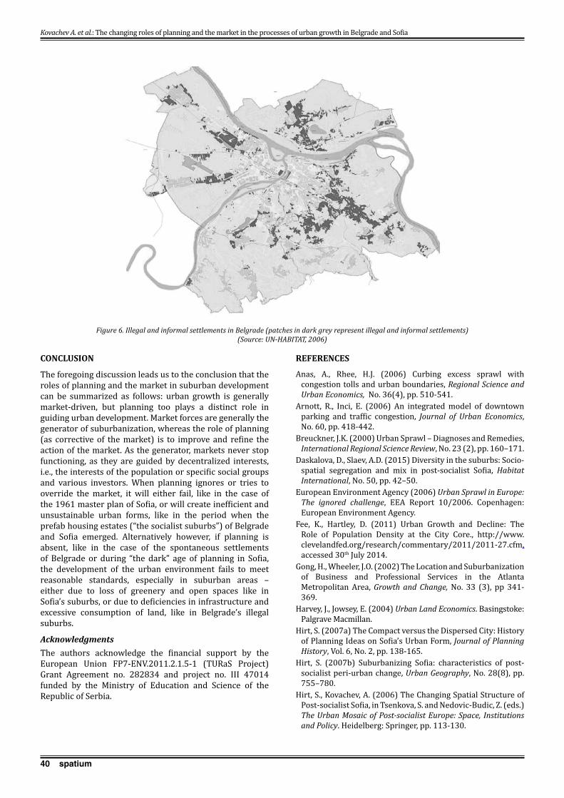
40 spatium
CONCLUSION
The foregoing discussion leads us to the conclusion that the roles of planning and the market in suburban development can be summarized as follows: urban growth is generally market-driven, but planning too plays a distinct role in guiding urban development. Market forces are generally the generator of suburbanization, whereas the role of planning (as corrective of the market) is to improve and refine the action of the market. As the generator, markets never stop functioning, as they are guided by decentralized interests, i.e., the interests of the population or specific social groups and various investors. When planning ignores or tries to override the market, it will either fail, like in the case of the 1961 master plan of Sofia, or will create inefficient and unsustainable urban forms, like in the period when the prefab housing estates (“the socialist suburbs”) of Belgrade and Sofia emerged. Alternatively however, if planning is absent, like in the case of the spontaneous settlements of Belgrade or during “the dark” age of planning in Sofia, the development of the urban environment fails to meet reasonable standards, especially in suburban areas – either due to loss of greenery and open spaces like in Sofia’s suburbs, or due to deficiencies in infrastructure and excessive consumption of land, like in Belgrade’s illegal suburbs.
AcknowledgmentsThe authors acknowledge the financial support by the European Union FP7-ENV.2011.2.1.5-1 (TURaS Project) Grant Agreement no. 282834 and project no. III 47014 funded by the Ministry of Education and Science of the Republic of Serbia.
REFERENCES
Anas, A., Rhee, H.J. (2006) Curbing excess sprawl with congestion tolls and urban boundaries, Regional Science and Urban Economics, No. 36(4), pp. 510-541.
Arnott, R., Inci, E. (2006) An integrated model of downtown parking and traffic congestion, Journal of Urban Economics, No. 60, pp. 418-442.
Breuckner, J.K. (2000) Urban Sprawl – Diagnoses and Remedies, International Regional Science Review, No. 23 (2), pp. 160–171.
Daskalova, D., Slaev, A.D. (2015) Diversity in the suburbs: Socio-spatial segregation and mix in post-socialist Sofia, Habitat International, No. 50, pp. 42–50.
European Environment Agency (2006) Urban Sprawl in Europe: The ignored challenge, EEA Report 10/2006. Copenhagen: European Environment Agency.
Fee, K., Hartley, D. (2011) Urban Growth and Decline: The Role of Population Density at the City Core., http://www.clevelandfed.org/research/commentary/2011/2011-27.cfm, accessed 30th July 2014.
Gong, H., Wheeler, J.O. (2002) The Location and Suburbanization of Business and Professional Services in the Atlanta Metropolitan Area, Growth and Change, No. 33 (3), pp 341-369.
Harvey, J., Jowsey, E. (2004) Urban Land Economics. Basingstoke: Palgrave Macmillan.
Hirt, S. (2007a) The Compact versus the Dispersed City: History of Planning Ideas on Sofia’s Urban Form, Journal of Planning History, Vol. 6, No. 2, pp. 138-165.
Hirt, S. (2007b) Suburbanizing Sofia: characteris tics of post-socialist peri-urban change, Urban Geography, No. 28(8), pp. 755–780.
Hirt, S., Kovachev, A. (2006) The Changing Spatial Structure of Post-socialist Sofia, in Tsenkova, S. and Nedovic-Budic, Z. (eds.) The Urban Mosaic of Post-socialist Europe: Space, Institutions and Policy. Heidelberg: Springer, pp. 113-130.
Figure 6. Illegal and informal settlements in Belgrade (patches in dark grey represent illegal and informal settlements) (Source: UN-HABITAT, 2006)
Kovachev A. et al.: The changing roles of planning and the market in the processes of urban growth in Belgrade and Sofia
41spatium
Holcombe, G.E. (2013) Planning and the invisible hand: Allies or adversaries? Planning Theory, 12(2), pp. 199–210.
Knaap, G.J. (2008) The Sprawl of Economics: A Reply to Jan Brueckner, in Cornia, G.C. and Riddell, J. (eds.) Toward a Vision of Land in 2015. Cambridge, MA: Lincoln Institute of Land Policy.
Kovachev, A. (2003a) Градоустройство, Част I. София: Пенсофт. [Kovachev, A. (2003a) Urban planning, Part I. Sofia: Pensoft.]
Kovachev, A. (2003b) Градоустройство, Част II. София: Пенсофт. [Kovachev, A. (2003b) Urban planning, Part II. Sofia: Pensoft.]
Kovachev, A. (2005) Зелената система на София, Урбанистични аспекти. София: Пенсофт. [Kovachev, A. (2005) The Green System of Sofia, Urban planning aspects. Sofia: Pensoft.]
Krunić, N., Maksin, M., Milijić, S., Bakić, O., Đurđević, J. (2014) Population dynamics and land cover changes of urban areas, Spatium, No. 31, pp. 22-29.
Moroni, S. (2010) Rethinking the theory and practice of land-use regulation: Towards nomocracy. Planning Theory, No. 9(2), pp. 137-155.
Moroni, S. (2015) Complexity and the inherent limits of explanation and prediction: Urban codes for self-organising cities, Planning Theory, No. 14(3), pp. 248-267.
Nedović-Budić, Z. (2001) Adjustment of planning practice to the new Eastern and Central European context, Journal of the American Planning Association, No. 67(1), pp. 38–52.
Nedović-Budić, Z., Tsenkova, S. (2006) The Urban Mosaic of Post-socialist Europe, in Tsenkova, S. and Nedović-Budić, Z. (eds.). The Urban Mosaic of Post-socialist Europe: Space, Institutions and Policy. Heidelberg: Springer & Physica-Verlag, pp. 3-21.
Nedović-Budić, Z., Cavrić, B. (2006) Waves of planning: Framework for studying the evolution of planning systems and empirical insights from Serbia and Montenegro, Planning Perspectives, No. 21(4), pp. 393–425.
Nedović-Budić, Z., Djordjević, D., Dabović, T. (2011) The Mornings after…Serbian Spatial Planning Legislation in Context, European Planning Studies, No. 19(3), pp. 429-455.
Nedović-Budić, Z., Zeković, S., Vujošević, M. (2012) Land Privatization and Management in Serbia: Policy in Limbo, Journal of Architectural and Planning Research, 29(4), pp.306-317.
Nivola, P. (1998) Fat city – Understanding American Urban Form from a Transatlantic Perspective. Brookings Review, Fall 1998, pp. 17-19.
Nikiforov, I. (2008) История на градоустройството. Варна: Издателство на ВСУ “Черноризец Храбър”. [Nikiforov, I. (2008) History of Urban Planning. Varna: Publishing House of VFU “Chernorizets Hrabar”.]
Nuissl, H., Haase, D., Lanzendorf, M., Wittlmer, H. (2009) Environmental impact assessment of urban land-use transitions - A context-sensitive approach, Land use policy, No. 26(2), pp. 414–424.
NSI (Nacionalen statisticheski institut) (2012) Census 2011- Population and Housing Fund, Volume 3, Book 23 Sofia (Capital). Sofia: National Statistical Institute.
Portugali, J. (2008) Learning from paradoxes about prediction and planning in self-organising cities. Planning Theory, No. 7(3), pp 248-262.
Ravetz, J., Loibl, W. (2011) The dynamics of the peri-urban: global change and regional response, in A. Piorr, I. Tosics and J. Ravetz (eds.), Peri-urbanization in Europe. Towards European Policies to Sustain Urban-Rural Futures. Syntesis Report. Copenhagen: PLUREL.
Roser, M., Ortiz-Ospina, E. (2017) – World Population Growth. Published online at OurWorldInData.org. https://ourworldindata.org/ world-population-growth/, accessed 18th Apr 2017.
Slaev, A. (2012) Definitions and Factors of Urban Sprawl in Europe – Scientific Almanac of Varna Free University, Vol. 6/2012, pp. 92-107.
Slaev, A. (2016a), Types of planning and property rights. Planning Theory, No. 15(1), pp. 23-41.
Slaev, A. (2016b), Property rights and methods of nomocratic planning. Planning Theory , No. 15(3), pp. 274-293.
Slaev, A. (2016c), The relationship between planning and the market from the perspective of property rights theory: A transaction cost analysis. Planning Theory, Epub ahead of print 26 Sept 2016. DOI: 10.1177/1473095216668670, pp. 1-21..
Slaev, A., Kovachev, A. (2014) Specific Issues of Urban Sprawl in Bulgaria, European Spatial Research & Policy, Vol. 21(2), pp. 155-169.
Slaev, A., Nikiforov, I. (2013) Factors of Urban Sprawl in Bulgaria, Spatium, No. 29, pp. 22-29.
Statistical Office of the Republic of Serbia (2012) Statistical yearbook of Serbia, 2011.
Turnbull, G.K. (2004) Urban Growth Controls: Transitional Dynamics of Development Fees and Growth Boundaries, Journal of Urban Economics, No. 55(2), pp. 215-237.
UNECE, (2009) Self-Made Cities, United Nations, New York.United Nations (2006). World Urbanization Prospects: The
2005 Revision. Department of Economic and Social Affairs, Population Division.
Vujošević, M, Nedović-Budić, Z. (2006) Planning and societal context — the case of Belgrade, Serbia. In Tsenkova S. and Z. Nedovic-Budic (eds.), Urban mosaic of post-socialist Europe: Space, institutions and policy. Heidelberg: Springer, pp. 275-293.
World Bank (2004) Serbia investment climate assessment, http://siteresources.worldbank.org/EXTECAREGTOPKNOECO/Resources/IC_SerbiaDraft.pdf, accessed 23rd Nov 2016.
Zeković, S., Vujošević, M., Maričić, T. (2015) Spatial regularization, planning instruments and urban land market in a post-socialist society: the case of Belgrade, Habitat International, Elsevier, 48, pp. 65-78.
Received March 2017; accepted in revised form May 2017.
Kovachev A. et al.: The changing roles of planning and the market in the processes of urban growth in Belgrade and Sofia
42 spatium
INTRODUCTION
The available potential for developing tourism in Serbian mountain regions has only been partly activated in the past for mountain tourism destinations (MTD) and mountain resorts. Serbian mountain regions have developed under the influence of trends in European countries, particularly in the Alps, which have influenced the studies and strategic plans for MTDs and mountain resorts the most. The main causes of the earlier, mainly negative trends in the development of tourism and the protection of mountain regions in Serbia lay less in the sphere of planning and much more in the unstable political and socio-economic conditions for development, as well as in the non-harmonized system of laws, competences, etc. The MTD development achieved is not the result of the strategic planning implementation, and neither can it be a significant model for the future development of other mountain areas in Serbia.
Over the past few decades, significant results have been achieved in the sustainable development of mountain regions and mountain tourism in Europe, while in Serbia the unsolved economic and social relationships, and unregulated market mechanisms, along with social and political contradictions, have slowed the development processes in MTDs and intensified the conflicts between tourism and the protection of natural heritage and natural resources and the quality of life of local communities. In this context, the main task is to identify the current mistakes, review the approaches to the development of tourism and complementary activities in MTDs in Serbia, and adjust and implement the European and other foreign experiences in a way that is tailored to our specific requirements (Maksin and Milijić, 2013).
Following on from previous research, conducted mainly at the Institute of Architecture and Urban & Spatial Planning of Serbia, this paper provides a comparative overview of the previous, current and expected trends in the development
RETROSPECTIVE OF AND PROSPECTS FOR THE DEVELOPMENT AND STRATEGIC PLANNING OF TOURISM IN THE MOUNTAIN REGIONS OF SERBIA
Saša Milijić, Institute of Architecture and Urban & Spatial Planning of Serbia, Belgrade, SerbiaSrđan Mićić, Institute for Recent History of Serbia, Belgrade, Serbia
Marija Maksin1, Institute of Architecture and Urban & Spatial Planning of Serbia, Belgrade, Serbia
Following on from previous research, this paper provides a comparative retrospective overview of trends in the development of mountain tourism destinations (MTDs) in European countries and their influence on MTD development in Serbia. The prospects for developing tourism in the mountain regions of Serbia follow the European trends and experiences in sustainable MTD development. These trends and experiences should be selectively implemented and adapted to the social and economic conditions, the characteristics of Serbian mountain regions and the effects on the local and regional spatial development. The paper gives a critical view of the role of strategic planning in developing tourism in Serbian mountain regions. The problems that have influenced the prevailing uncontrolled development of MTDs, the marginalization of the role of strategic planning and the limited implementation of spatial planning in their development have been identified. The possibilities for achieving the coordinating role of spatial planning in strategic planning were assessed for the National Park and MTD Kopaonik. In this case the harmonization of the various sectoral plans and programs, the multisectoral coordination of development entities in the public sector, participation in the planning process and partnerships in decision making and implementation have been achieved in the process of spatial planning, and this should be implemented for other MTDs and improved in the future.Key words: mountain tourism destinations in Serbia and European countries, tourism development, strategic planning, spatial planning, sustainable spatial development.
1 Bulevar kralja Aleksandra 73/II, 11000 Belgrade, Serbia [email protected]
UDC 711(23.0)(497.11):502.131.1 711(497.11):338.48-6 Review paperDOI: https://doi.org/10.2298/SPAT1737042M
SPATIUM No. 37, June 2017, pp. 42-48

43spatium
of MTDs in European countries and their achieved and potential influence on the development of MTDs in Serbia. This analysis represents a starting point for identifying key problems and exploring possibilities for improving the role of strategic planning in the future planning guidance and management of the sustainable spatial development of MTDs in Serbia.
RETROSPECTIVE ON THE DEVELOPMENT AND STRATEGIC PLANNING OF TOURISM IN SERBIAN MOUNTAIN REGIONS RELATIVE TO EUROPEAN TRENDS
Retrospective on tourism development in the mountain regions of Serbia relative to European trends
The first types of organized tourism (urban and spa tourism) emerged in Serbia at the end of the first decade of the 20th century under the direct influence of the overall development as well as that of tourism in Europe, while the organized development of mountain winter tourism began in the 1970s. Tourism development in the mountain regions of Serbia has undergone five phases so far (Mitrović, 1983; Dabić, 1996; Milijić, 2005; Maksin et al., 2011; Maksin and Milijić, 2013; Milijić, 2015):
• Initial phase – from 1901 until the Second World War.• Preparatory phase – from the end of the Second World
War until 1968. • Development phase – from 1968 until 1990.• Phase of crisis – from 1990 until 2007.• Gradual recovery phase – from 2007 onwards.
A brief comparative overview of the characteristics of and relationship between these phases and the processes and trends in tourism in the mountain regions of European countries, primarily those of the Alpine countries, is given in Table 1.
The common characteristic of all generations of MTDs in Alpine countries is that they are located in the mountain snow zones or in their immediate vicinity, with ski slopes on which the snow cover remains throughout the winter. This condition was determinant for planning and developing the resorts in the higher, most valuable and most attractive zones of the mountains, on the boundaries between forests and pasture areas. At the beginning of their development, the mountain resorts earned most of their income from tourism in the winter season. With the development of the tourism industry, the offer also included tourism programs outside the winter season. Today, the traditional mountain resorts are earning most of their income from tourism during the summer season, thus they have become all-year-round destinations. Tourism has been the main regional development potential in most parts of the Alps, but it is believed that tourism cannot be the only bearer of development, due to which special attention is paid to a balanced development and relativization of the conflicts between tourism, agriculture and tourism, and the protection of nature and the environment. In this process, preserving the natural environment of mountain regions and enabling a better quality of life for the local residents are striven for. The key role in the development of mountain resorts, starting from the second generation of mountain resorts, is the state’s role in the planning guidance and management of MTDs and their tourism offer, whereby
Milijić S. et al.: Retrospective of and prospects for the development and strategic planning of tourism in the mountain regions of Serbia
Serbia Alpine countries
Phase of theMTD development
Characteristics:1. Altitude criterion for MTDs2. The dominating offer - W, S, AYR3. Characteristics of the MTD development - SD, P, R, UD
Period Phase – Generation of MTDs
Characteristics:1. Altitude criterion for MTDs2. The dominating offer - W, S, AYR3. Characteristics of the MTD development -SD, P, R
Period
Initial phase
1. Beginning of mountain recreation and tourism2. S3. SD
1901-1940 1st generation of MTDs1. Lower and middle altitudes2. S3.SD-P
Late 19th century - early 20th century
Preparatory phase
1. Lower and middle altitudes2. S, initiated W3. SD
1945-1968 2nd generation of MTDs1. 1200-1500m2. W3. P
1945-1970
Development phase
1. New MTDs> 1500 m2. W3. P
1968-1990 3rd generation of integrated MTDs
1. 1500 - (>)2000m2. W3. P
1970-1980
Phase of Crisis1. -2. W in higher, S in other mountains3. UD
1990-2007 4th generation ofPolyvalent MTDs
1. 2000-1000 m2. W→AYR3. P
1980-2005
Gradual recovery phase
1. -2. AYR in higher, S in other mountains3. R, with occurrence of UD
2007 - 5th generation of MTDs1. above 1600 m2. AYR3. P, R
2005 -
List of abbreviations: MTD–mountain tourism destination, W–winter tourism, S–summer tourism, AYR–all year round tourism, SD – spontaneous development, P–planned development, R – re-planning, UD – uncontrolled development
Table 1: Comparative, chronological overview of tourism development in the mountain regions of Serbia and Alpine countries

44 spatium
the state develops partnerships with the private sector and includes all relevant actors and local communities in the decision making process (Richins et al., 2016), which recently evolved into a collaborative planning process (Richins, 2016).
The state had a determinant role in the planning guidance for MTD development and in its management in Serbia in the preparatory and development phases. The phase of crisis in the development of mountain regions began in 1990 when the system of planning guidance for developing MTDs was abandoned and their development was left to the influences and interests of spontaneous and uncontrolled market operations, when stagnation and unbalanced and uncontrolled MTD development took place. The sustainability of MTDs is being challenged, since the economic interests of the tourism industry for intensive construction of tourism facilities and their spatial concentration prevail. Proposed developments may cause negative impacts on the environment, as well as on the social and economic development of local communities (Maksin and Milijić, 2013). The gradual recovery phase that tentatively began in 2007 is characterized by the intensification of the state’s investments in the formation of public ski resorts, the development of capital infrastructure, etc., but still without sufficient alignment of the spatial development of tourism destinations with the protection of mountain regions (Dabić et al., 2009).
The problem of managing MTD development has manifested itself in all phases, but it culminated in 1990 when any form of management was lost. In addition, selecting and using appropriate management models has been constantly postponed, as indicated by the recently adopted Tourism Development Strategy of the Republic of Serbia 2016-2020 (2016).
Critical view of the role of strategic planning in tourism development in the mountain regions of Serbia
In certain phases of MTD development, the sectoral planning basis for developing tourism in Serbia has included different development program modalities –within the plans for socioeconomic development in the preparatory phase of development and master plans for tourism development in the period 2007-2012 (Dabić et al., 2009).
The planning basis for the protection and spatial development of mountain tourism in Serbia was formed after 1968 and improved in the next phases of MTD development. The first planning basis included urban plans for tourism localities in the lower mountain regions suitable for summer tourism. For this reason, the consideration of the overall potential and resources for tourism development in MTDs failed to take place, and neither was there any consideration of the possibilities for integrating the tourism offer with the surroundings or the identification of problems of environmental protection and the protection of natural and cultural heritage. The theoretical and methodological knowledge in the field of overall spatial planning and spatial planning for mountain regions in Serbia was first used when drawing up the Regional Spatial Plan for the area of 10 municipalities in the Kopaonik massif 1968-1971, then in the regional program for tourism development in the
western parts of the Sar-planina and Prokletije mountains (1972), while the spatial plans for the special purpose areas for MTDs have increasingly gained importance over time (Dabić and Milijić, 1998).
The elements of the contemporary holistic and problem approaches to MTD planning have been introduced under the influence of the European experiences, particularly the experiences of the Alpine countries (Milijić, 2005; Maksin et al., 2011; Dabić et al., 2009; Milijić, 2016).The Spatial Plan of the Republic of Serbia (1996) was the first strategic document to establish sustainable territorial development and to introduce the concept of the sustainable spatial development of tourism in the entire territory of Serbia. The tourism regions/destinations identified in the national spatial plan (1996, 2010) are predominantly situated in the mountain regions of Serbia south of the river Danube. Starting from the end of the third phase of MTD development, spatial plans for special purpose areas (SPSPA) have been continuously adopted for all MTDs, which are mostly protected areas as well. The special purposes for which SPSPAs are developed are dominant and can be a source of significant environmental impacts and impacts on the quality of life of local residents, but also a cause of conflict between tourism and the protection of natural heritage and natural resources, as well as between tourism and the development of local communities. For this reason, the existing and potential tourism related conflicts have been identified and minimized in the process of drawing up the SPSPAs for MTDs and carrying out a strategic assessment of their impacts relative to other purposes and activities, thus enabling the selection of the planning solutions that contribute to the sustainable territorial development of MTDs and protected areas.
The problem of coordinating spatial and environmental factors with the sector planning framework is most pronounced in the tourism sector in current Serbian planning practice, namely in the fifth phase of MTD development. While the Tourism Development Strategy of the Republic of Serbia (2006) was, to some extent, linked to spatial planning - the Spatial Plan of the Republic of Serbia (1996), this cannot be said for the new Tourism Development Strategy of the Republic of Serbia for the period 2016-2020. Although the new strategy indicates the problem of the lack of a standardized integrated system of planning, management and coordination of the development of tourism regions, the determinants of this sectoral strategic framework do not provide even the basic preconditions for overcoming the problems in coordinating the sectoral planning and the spatial and environmental planning and problems in forming an integrated system of strategic and operational planning for these regions. Both strategies envisage that the determinants should be elaborated through the strategic master plans and tourism development programs, and they also establish an obligation according to which a strategic master plan should be a starting basis for drawing up the spatial, urban and other plans for tourism destinations. The implementation of this obligation since 2007 has contributed to the intensification of conflicts between tourism and other purposes, as well as to disabling the sustainable development of MTDs. Due to the market-
Milijić S. et al.: Retrospective of and prospects for the development and strategic planning of tourism in the mountain regions of Serbia

45spatium
driven approach and partial overview of developing tourism destinations used, substantial negative effects of tourism on natural heritage, resources and the environment, as well as on local community development and the quality of life of local residents can manifest themselves in the implementation of the master plans for the MTDs in Stara Planina, Golija and Kopaonik. After adopting the tourism development master plans for these MTDs, a significant problem occurred in developing the SPSPAs for these areas. Without prior verification and without achieving spatial, environmental, social and economic sustainability, concepts and solutions based exclusively on the sector (economic) approach in tourism development master plans jeopardize the planning concepts and solutions based on the holistic approach in SPSPAs (Dabić et al., 2009; Maksin et al., 2011). Although SEA is not being applied to master plans in the tourism sector for the time being, its application in SPSPA has contributed to achieving a certain balance between the sectoral and holistic approaches to development and protection, with a view to achieving the sustainable territorial development of MTDs (Nenković-Riznić et al., 2016).
Since 1990, the lack of coordination between sectoral planning in tourism and spatial and environmental planning, the lack of support for the implementation of planning documents, and the domination of political and covert influences in decision making have contributed to the prevailing uncontrolled development of MTDs, the marginalization of the role of strategic planning and the limited implementation of spatial planning in their development.
PROSPECTS FOR THE DEVELOPMENT AND STRATEGIC PLANNING OF TOURISM IN THE MOUNTAIN REGIONS OF SERBIA RELATED TO THE EUROPEAN TRENDS
Prospects for tourism development in the mountain regions of Serbia relative to European trends
The integrated development of mountain destinations in European countries will continue to be based on the achievement of three goals: economic and social cohesion; sustainable development; and balancing the competences in management. In the future, tourism will also be a basis for the sustainable development of mountain regions in European countries. The long-term commitment of the Alpine MTDs lies in the intensification of their all-year-round tourism offer in which winter tourism will continue to play a significant role (Macchiavelli, 2009; Milijić, 2015).
The interest in high mountain resorts (above 1500m) declined in the Alpine countries over a relatively short period, from 2000 until 2005, due to the high costs of construction and use, so that the trend was mostly redirected towards more rational, traditional and new mountain resorts and settlements at lower altitudes. However, the coming period will be marked by new approaches conditioned by economic recession, changes in interests and the scope of demand, as well as by climate change and investment policies related to climate change which, as a rule, grant loans for mountain ski resorts at an elevation above 1600m. The present trends are towards an innovative winter and summer mountain
tourism offer, rather than the growth of existing towns and resorts, as well as the balanced and modest development of new tourist resorts (Schmidt et al., 2016).
The management of sustainable MTD development is a process that includes the securing of different supports in carrying out the priorities and phases of development, as well as the control and monitoring of implementing the planning decisions. The experiences of Alpine countries in terms of the state’s role in managing sustainable MTD development (Macchiavelli, 2009; Richins, 2016; Schmidt et al., 2016), adapted to the local conditions, should be used in Serbia, including:
• Strict control of the protection of natural heritage, natural resources and the environment, and control of the use and development of the area.
• Integration and unified policies implemented by the majority of stakeholders in MTDs.
• Organizational and strategic innovations to provide the flexibility to face the challenges imposed by the market.
• Cooperation and collaboration in developing the planning basis (for the spatial, urban and sectoral plans, policies and programs) and defining the priorities of development.
• The establishment of an optimum model for managing the protection and development of MTDs (e.g. a “corporate model” in which tourist property ownership and services are managed by a single company), along with different modalities of the participation of private and non-government sectors and local communities.
• Specialization of the sectoral and multisectoral state and para-state organizations in the management of sustainable development of regions and sustainable tourism.
• The provision of incentive measures (financial, fiscal, etc.) for initiating and carrying out efficient, profitable and attractive tourism and recreational activities, or the provision of correctional and restrictive measures when tourism development causes a certain degradation of natural resources (but has significant socio-economic benefits), or when, in spite of the availability of resources, the tourism development is not successful (alternative directions of development).
• The introduction of development certificates (licenses) as a form of controlling MTD development, i.e. operation of the tourism and other facilities aimed at protecting the quality of services and the environment.
On the basis of the Alpine countries’ and Serbian experiences in developing MTDs, the main measures for achieving the sustainable development of MTDs in Serbia would be the following (Milijić and Dabić, 2004):
• In the initial stages of the MTD activation, the state should play a priority role in the plan-based development and management of the transport and utility infrastructure and certain non-commercial contents of the public standard, in the tourism infrastructure and equipment, and in the land acquisition and land development.
Milijić S. et al.: Retrospective of and prospects for the development and strategic planning of tourism in the mountain regions of Serbia

46 spatium
• In the next stages of the MTD development, it is necessary to control the preparation and implementation of the development projects based on their proven ecological suitability, economic viability and social acceptability for the local residents.
• In all stages of development, it is necessary to encourage the use of the model for sparsely distributed localities which have smaller parts in the altitude zones of mountains and greater parts in the sub-mountain settlements, as the most acceptable model for developing MTDs.
• In all stages of development, it is necessary to direct and support the development of all-year-round tourism with competitive tourism products and a presentation of all the advantages of the region.
It can be expected that in Serbia climate change will contribute to the balancing of the summer tourism offer and demand with the winter tourism offer and demand, as well as to a more intensive activation of the priority high-mountain regions, but also the activation of lower- and middle-altitude mountain regions and other tourism resources in their regional surroundings.
The role of the state as an initiator of and partner in the planning guidance and management of MTD development will be decisive in achieving the sustainable territorial development of MTDs in European countries and in Serbia. The national level of management in Serbia should play a more active role in integrating the strategic planning and management of sustainable development, particularly the sustainable development of high-mountain MTDs, given that the regional level of management has not been established, while the experiences of MTD development since 2007 have shown that the prevailing interest of local-level management is to intensify real estate development for the purpose of collecting revenue on this basis.
The management models should be differentiated according to the level of development of MTDs – from the MTDs in an advanced stage of development, such as Kopaonik and Zlatibor, to the MTDs in the initial stage of development, such as Mt Stara planina and Golija. In this context, the dynamics of establishing appropriate management models should be speeded up and differentiated relative to the Tourism Development Strategy of the Republic of Serbia for the period 2016-2020.
The expected role of strategic planning in developing tourism in the mountain regions of Serbia relative to European trends
The approach to defining the starting bases in the strategic planning of tourism development in mountain regions of Serbia should be based on the European Charter for Sustainable Tourism in Protected Areas, the Strategy for Sustainable Tourism in Europe’s Nature and National Parks, Guidelines of the European Commission on Mountain Areas and European Integration, and other international documents (Milijić, 2015).
The strategic planning of sustainable tourism in the mountain regions of Serbia should be based on the use
of the most successful examples of European practice adapted to the local conditions. The trends in managing development in European countries show the integration of spatial and environmental planning within the institutional and organizational models that have a coordinating role in planning and directing territorial development.
The coordinating and integrating role of spatial planning in strategic planning, and in managing and achieving sustainable territorial development should be supported, particularly in the sensitive and protected mountain areas. It is necessary to align different sectoral plans and programs in the spatial planning process and to achieve multisectoral coordination among all competent entities of development in the public sector, as well as participation in the planning process, the establishment of partnerships between all key participants/actors in decision making and the implementation of planning decisions to enable the coordination and integration of strategic planning within the decision making in managing MTD development. For making and implementing planning decisions, it is also necessary to provide a monitoring system for the natural heritage and the environment, construction, land development and development of the tourism offer, as well as to establish an integrated management system for MTDs (tourism development, the protection of nature and the environment, etc.).
In the case of MTDs, spatial planning should achieve a coordinating role primarily in relation to the sectoral planning basis for the protection of nature (protected area management plans) and development of tourism (strategic master plans and tourism development programs).
The basic principles for the relativization of conflicting interests related to the protection of natural heritage and natural resources and tourism development include: the participation of tourism in the protection and improvement of nature; responsibility for damages and compensation; and the inclusion of local residents in the protection, promotion and use of nature and local products. The achievement of these principles in the strategic planning process requires a series of actions, from the determination of the capacity of the area, through the presentation of the natural and cultural heritage of the area, to the organization of the all-year-round tourism offer in the area and activation of the potentials of local residents. It is necessary to re-examine the concept of resort development and the capacity of stationary users in the altitude zones of MTDs in accordance with the new approaches and decisions from international financial institutions on investments in mountain areas, and where they are built. It is necessary to, in a strategic sense, “rehabilitate” them by developing the infrastructure, landscape, etc. The strategic concept should be to direct the focus of future tourism development towards so-called secondary resorts and tourism settlements in the lower altitude zones of mountains that will be well connected by vertical transport systems to the altitude zones. It is also necessary to establish and implement the priorities in and stages of development of infrastructure systems and mountain resorts (Milijić, 2015).
Milijić S. et al.: Retrospective of and prospects for the development and strategic planning of tourism in the mountain regions of Serbia
47spatium
In Serbia, the attitudes towards MTD development have generally always been linked to experiences in the development of the Kopaonik region. The norms and standards used in developing the Kopaonik MTD have relied on the norms and experiences of France and Switzerland. The Suvo Rudište mountain resort in Kopaonik represents a good example of the realization of MTD development in the period before 1990 (Milijić and Dabić, 2004). However, since then it has been an example of the escalation of all of the problems and conflicts in MTD development – uncontrolled construction and the non-observance of the SPSPA rules due to pressure from investors and the local level of management to develop accommodation capacities which threaten the most valuable protection zones, as well as ski infrastructure development. There is also a lack of any form of management of tourism and MTD development, etc. Relative to other MTDs, this region has the longest tradition and continuity in developing SPSPAs – the first one was in1989, and the last one in 2016.
The new methodological approach used in developing the SPSPA for Kopaonik from 2016 can be a directive approach for realizing the coordinating role of spatial planning in MTD strategic planning. The new methodological approach is based on the combined use of the integrated and participative approaches in the decision-making process on the protection and sustainable development of MTDs. Through the process of developing the SPSPA, the key conflicts in the protection and sustainable spatial development of MTDs were identified – between tourism and the protection of natural heritage and biodiversity, between the local residents and the protection of natural heritage and natural resources, and between the local residents and tourism. In the next methodological step, the strategic commitment for the relativization of the identified conflicts served for checking the sustainability, the coordination and relativization of conflicting sectoral decisions on the protected areas (from the Law on National Parks and Decree on Protection Regimes) and decisions on the protection of cultural heritage, as well as the development of tourism (from the Master Plan for Tourism Destination Kopaonik and urban plans for tourism sub-resorts in the National Park) and development of infrastructure systems, and the development decisions of the local-level management. Based on these checks, and starting from good European practice in managing protected areas and MTD development, several scenarios for the coordination and relativization of the conflicting sectoral and development decisions were prepared – scenarios for the differentiation of the protection zones with the most suitable ski slopes and localities for the development of mountain resorts. The compromise solution for aligning the zones for tourism and recreational infrastructures with stricter natural heritage protection regimes was selected. It was necessary to use the participative approach for achieving the coordination and relativization of conflicts in a way in which, besides the protected area managers, the key actors at national and local levels of management in the protection of natural resources and the environment, tourism, ski resorts and spatial planning were also included in the process of considering the scenarios offered and making decisions on the selection of the most suitable one.
CONCLUSIONS
The development of tourism in the mountain regions of Serbia will take place following European trends. Alpine countries’ experiences in sustainable MTD development will be selectively implemented and adapted to the local socioeconomic conditions, characteristics of mountain regions and effects on the local and regional territorial development.
The intensification of the all-year-round tourism offer for MTDs in which winter tourism will continue to dominate is a precondition for activating the available potential and for more intensive tourism development. It can be expected that climate change will contribute to balancing the summer tourism offer and demand for it with the winter tourism offer and related demand, as well as to a more intensive activation of high-mountain MTDs, but also the activation of the lower- and middle-altitude mountain areas and other tourism resources in their regional surroundings.
The role of the state as an initiator and partner will be decisive in the planning guidance and management of the sustainable territorial development of MTDs and their regional surroundings. The national level of management in Serbia should achieve a significant role in integrating the strategic planning and management of sustainable development, particularly in the high mountain MTDs.
For integrating strategic planning into the decision making process for managing the development of MTDs, it is necessary to align different sectoral plans and programs through the spatial planning process, primarily in the nature protection and tourism development sectors, and to achieve a multisectoral coordination among all competent entities of development in the public sector and realize the participation in the planning process, as well as to establish partnerships and collaboration between all key participants/actors in decision making on and implementation of planning decisions. The necessity for and possibility of achieving the coordinating role of planning have been checked and confirmed in the process of spatial planning for the Kopaonik National Park, the key area in the Kopaonik MTD. Starting from the key problems and conflicts in the protection and sustainable spatial development of the Kopaonik National Park identified in the process of developing the SPSPA, it is recommended that the national level of management should achieve a more active role in the process of sustainable MTD development through the overall control of the processes of planning and developing MTDs. For this reason, the commitment that has prevailed is to carry out a detailed elaboration of urban planning for all the contents of the tourism offer in the protected areas exclusively within the SPSPA and to continue the previous practice in elaborating the SPSPA through corresponding urban plans outside the boundaries of the protected areas.
AcknowledgmentsThis paper is result of the projects “Sustainable Spatial Develo-pment of Danube Area in Serbia”, No. TR 36036 and “Serbs and Serbia in the Yugoslav and International Context: Internal Development and Position within European/World Community”, No. 47027, both financed by the Ministry of Education, Science and Technological Development of the Republic of Serbia in 2011-2017.
Milijić S. et al.: Retrospective of and prospects for the development and strategic planning of tourism in the mountain regions of Serbia

48 spatium
REFERENCES
Dabić, D. (1996) Teorijski, metodološki i planski okviri prostornog planiranja turističkih područja, in: Prostorno planiranje, regionalni razvoj i zaštita životne sredine 2, Beograd: Institut za arhitekturu i urbanizam Srbije, pp. 21-131. [Dabić, D. (1996) Theoretical, methodological and planning framework for spatial planning of tourism areas, in: Spatial planning, regional development and environmental protection, Belgrade: Institute of Architecture and Urban & Spatial Planning of Serbia, pp. 21-131.]
Dabić, D., Milijić, S. (1998) A contribution to the history of tourist development in Serbia, Spatium, No. 4, pp. 27-34.
Dabić, D., Mitrović, S., Milijić, S. (2009) Strategic planning of the spatial development of sustainable tourism and its limits in Serbia, in: Regional development, spatial planning and strategic governance, Thematic Conference Proceedings, Belgrade: Institute of Architecture and Urban & Spatial Planning of Serbia, Vol. 1, pp. 239-258.
Decree on Protection Regimes (2012)/Uredba o režimima zaštite, “Official Gazette of the Republic of Serbia”, No. 31/2012.
Horwath HTL (2009) Master plan za turističku destinaciju Kopaonik, Finalni Izveštaj, Ministarstvo ekonomije i regionalnog razvoja Republike Srbije, Beograd. [Horwath HTL (2009) Master Plan for the Kopaonik Tourism Destination, Final Report, Ministry of Economy and Regional Development of the Republic of Serbia, Belgrade.]
Law on National Parks (2015) /Zakon o nacionalnim parkovima, “Official Gazette of the Republic of Serbia”, No. 84/2015.
Law on the Spatial Plan of the Republic of Serbia (1996)/Zakon o prostornom planu Republike Srbije, “Official Gazette of the Republic of Serbia”, No.13/1996.
Law on the Spatial Plan of the Republic of Serbia for period 2010-2020/Zakon o prostornom planu Republike Srbije za period 2010-2020, “Official Gazette of the Republic of Serbia”, No.88/2010.
Macchiavelli, A. (2009) Alpine tourism: development contradictions and conditions for innovation, Journal of Alpine Research, 97(1), pp. 99-115.
Maksin, M., Pucar, M., Milijić, S., Korać, M. (2011) Održivi razvoj turizma u Evropskoj uniji i Srbiji, Posebna izdanja 67. Beograd: Institut za arhitekturu i urbanizam Srbije. [Maksin, M., Pucar, M., Milijić, S., Korać, M. (2011) Sustainable tourism development in the European Union and in Serbia, Special editions 67. Belgrade: Institute of Architecture and Urban & Spatial Planning of Serbia.]
Maksin, M., Milijić, S. (2013) Sustainable spatial development of tourism destinations in times of crises in Serbia, in: Janković, S. and Smolčić Jurdana, D. (eds.) Tourism in Southern and Eastern Europe 2nd International Scientific Conference: Crisis – a challenge of sustainable tourism development?, Vol. 2, Opatija: Faculty of Tourism and Hospitality Management, pp. 185-200.
Мilijić, S. (2005) Strategija razvoja planinskih područja Srbije, doktorska disertacija, Beograd: Geografski fakultet. [Мilijić, S. (2005) Strategy for Development of Mountain Regions of Serbia, Doctoral dissertation, Belgrade: Faculty of Geography.]
Milijić, S., Dabić, D. (2004) Prostorni razvoj planinskih područja Srbije, in: Strateški okvir za održivi razvoj Srbije, Beograd:
Institut za arhitekturu i urbanizam Srbije, pp. 191-206. [Milijić, S., Dabić, D. (2004) Spatial development of mountain regions of Serbia, in: Strategic framework for sustainable development in Serbia. Belgrade: Institute of Architecture and Urban & Spatial Planning of Serbia, pp. 191-206.]
Milijić, S. (2015) Održivi razvoj planinskih područja Srbije. Posebna izdanja 77. Beograd: Institut za arhitekturu i urbanizam Srbije. [Milijić, S. (2015) Sustainable development of mountain regions in Serbia. Special editions 77. Belgrade: Institute of Architecture and Urban & Spatial Planning of Serbia.]
Mitrović, S. (1983) Problemi izgradnje planinskih sportskih centara sa stanovišta zaštite prirode i turizma. Posebna izdanja 13. Beograd: Republički zavod za zaštitu prirode Srbije. [Mitrović, S. (1983) Problems of ski resort development from the aspect of environmental protection and tourism. Special editions 13. Belgrade: Institute for Nature Conservation of Serbia.]
Nenković-Riznić, М., Ristić, V.,Milijić, S., Maksin, M. (2016) Integration of the SEA and ESIA into the Strategic Territorial Planning: Lessons Learned from two Cases of Tourism Destinations in the Protected Areas, Polish Journal of Environmental Studies, Vol. 25, No. 3, pp. 1353-1366.
Richins, H., Johnsen, S., Hull, J. (2016) Overview of Mountain Tourism: Substantive Nature, Historical Context, Areas of Focus, in Richins, H. and J. Hull (eds.) Mountain Tourism: Experiences, Communities, Environments and Sustainable Futures, CABI, UK, pp. 1-12.
Richins, H. (2016) Experience Provision in Mountain Tourism: Overview, Contextual Development and Emphasis, in Richins, H. and J. Hull (eds.) Mountain Tourism: Experiences, Communities, Environments and Sustainable Futures, CABI, UK, pp. 13-24.
Schmidt, J.T., Wernen, C., Richins, H. (2016) Mountain Tourism in Germany: Challenges and Opportunities in Addressing Sustainability of Garmisch-Partenkirchen, in Richins, H. and J. Hull (eds.) Mountain Tourism: Experiences, Communities, Environments and Sustainable Futures, CABI, UK, pp. 255-280.
Spatial plan for the Special Purpose Area of the Kopaonik National Park (2016)/Prostorni plan područja posebne namene nacionalnog parka “Kopaonik“, “Official Gazette of the Republic of Serbia”, No. 89/2016.
Tourism Development Strategy of the Republic of Serbia (2006)/Strategija razvoja turizma Republike Srbije, Government of the Republic of Serbia, Belgrade.
Tourism Development Strategy of the Republic of Serbia for period 2016-2020(2016)/Strategija razvoja turizma Republike Srbije za period 2019-2020, “Official Gazette of the Republic of Serbia”, No.98/2016.
Milijić S. et al.: Retrospective of and prospects for the development and strategic planning of tourism in the mountain regions of Serbia
Received March 2017; accepted in revised form June 2017.
49spatium
INTRODUCTION
Contemporary trends in the domain of urban governance largely consider the nature of planning process, but not necessarily its final outcome. More precisely, understanding the planning not only as physical planning aimed at making plans as a final planning product, but placing an emphasis on the planning process itself, elucidates various aspects: consensus-building (Healey, 1997; Barrett and Fudge, 1981; De Roo, 2007), redefining the roles of participants and their relationships (Sager, 1994; Rydin, 2007), as well as the achievement of stakeholders’ equality and institutional transparency (Healey, 2007; Innes, 1996). Considering the above mentioned aspects and their interrelations strongly affected the communicative turn in both the planning theory and practice. The main features of the collaborative planning can be illustratively explained through its comparison to the rational planning, which stood for a dominant model of
spatial development governance through the second half of the 20th century. Briefly put, the comprehensive rational urban planning model is based on the strong role of the state, i.e. representative democracy, a realization of the optimal urban form based on the professional expertise (instrumental rationality), and a definition of the public interest and a tendency towards its fulfillment (Faludi, 1973; McLoughlin, 1969; Ennis, 1997; Taylor, 1999). In contrast to this, the collaborative planning corresponds to the context of deliberative democracy, thus focusing on the collaborative rationality: cooperation among numerous stakeholders, exchange of information and different types of knowledge – expert and experiential, and harmonization of various interests hence achieving the so-called collective interest (Forester 1989, 1999; Healey, 1992, 1995; Innes, 1995; Sandercock, 1998; Booher and Innes, 2002).
However, from the theoretical point of view, there are several criticisms of the collaborative planning model: it is said to be dominant in relation to other theoretical discourses; there is a lack of argumentative justification of the model itself; and, its theoretical base is rather ambiguous (Allmendinger,
SPATIAL AND URBAN PLANNING IN SERBIA: A LOOk THROUGH THE LENS OF
DELIBERATIVE APPROACH
Ana Perić, ETH Zurich, Institute for Spatial and Landscape Development, Zurich, Switzerland University of Belgrade, Faculty of Architecture, Belgrade, Serbia
Milutin Miljuš1, University of Belgrade, Faculty of Architecture, Belgrade, Serbia
In planning, the deliberative process is most commonly present in the form of a structured public discussion. The main idea behind such an approach is to improve communication among different participants by informing them about a local problem before any stakeholders’ preference is adopted, agreement reached and, finally, the problem solved. With the help of a mediator, an independent third party, the participants are considered equal, rational and free to give their opinion. Such a deliberative approach is an integral part of most planning procedures in developed countries. However, the enhancement of the planning process in the post-socialist context is delayed due to institutional rigidities, public mistrust towards the initiators of spatial development, and the lack of mediation procedures in the planning process. Previous features are also specific to Serbia, as a transitional state, which, nevertheless, experienced a somewhat different social context in comparison to other Eastern Bloc countries during the second half of the previous century. To understand the contemporary situation better, the paper provides an overview of spatial and urban planning in Serbia since the Second World War, observed from the deliberative stand, in an attempt to define the basic guidelines for the transformation of the planning approach in Serbia.Key words: deliberative democracy, deliberation, rationality, spatial and urban planning, Serbia.
1 Bulevar kralja Aleksandra 73/II, 11000 Belgrade, Serbia [email protected]
UDC 711.24(497.11)”1945/...”Review paperDOI: https://doi.org/10.2298/SPAT1737049P
SPATIUM No. 37, June 2017, pp. 49-57
50 spatium
2002). In the practice of the collaborative planning, not all the stakeholders are equal in their opportunities, rights, and time for debate, while some participants are not able to understand the attitudes and viewpoints of others (Sandercock, 1998). Since planning practice is deeply embedded into certain context, the debate elucidates the stakeholders with real power (be this particular expertise, public authority position, financial resources, etc.), which then affects the understanding and defining the various types of rationality (Flyvbjerg, 1998). Finally, the professional competence of planners as stakeholders equal to others in the processes that highly endanger the public interest is deeply contested (Baxamusa, 2008).From the previous, it seems that current planning approaches are not capable of facing the non-linear nature of messy policy problems. Therefore, some scholars place an emphasis on deliberation (Dryzek, 1990; Sager, 2002; Hirt, 2005; Laurian, 2007). Deliberation as a method should have an effect on the selection of a course of action after careful consideration and dialogue among involved parties, supported by arguments (Goodin, 2008). To some extent, this kind of approach is similar to the collaborative approach. Nevertheless, through deliberation the participants are to be encouraged not only to overcome the idea of consensus building, but also to face the mutual problem solving (Fischer and Gottweis, 2012). Moreover, deliberation is aimed at creating acceptable plan for the optimal organization of the participants’ activities, which, respectively, affect and modify the participants’ needs in order for the goals and interests to be reconciled (Forester, 1993). Such a ‘scheme of behaving’ (Rawls, 1999) in a deliberative process corresponds to a certain extent to the highly structured premises of the rational planning model. Nevertheless, the instrumental rationality of experts does not prevail in the deliberative approach: the planners aim at compensating the imbalance of power in society through making the public discussions on the urban development issues transparent, constructive, and respectful of differences (Fishler, 2012). Emphasizing the role of planners as mediators (and not the stakeholders equal to others) in the participatory planning and decision-making processes is another specificity of the deliberative approach, particularly when compared to the collaborative one (Forester, 1999).Through the lens of historical development, the involvement of various stakeholders in the planning process and, thus, making their voices heard was not experienced equally in Europe during the second half of the 20th century. Namely, value assessment (except the values prescribed by the dominant ideology) was a strongly missing component in the social and political context of the so-called Eastern Bloc. In contrast to other communist countries behind the Iron Curtain, Yugoslavia was considered a socialist state, thus allowing for some innovative, participatory instruments in the domain of spatial and urban planning. However, the circumstances of the Yugoslav fragmentation in the 1990s caused the centralization of decision-making, thus emphasizing the ‘top-down’ approach reflected in the planning field, too. Today, despite the tendency to follow and align with European standards, the undeveloped fundamental institutions of the democratic and market-oriented society cause the lack of the necessary rationality
in the planning approach (Lazarević Bajec, 2009). Hence, the paper analyzes spatial and urban planning in Serbia through outlining the basic features of the deliberative planning approach. More precisely, the paper seeks to identify the extent of deliberation in the decision-making processes observed through various periods of Serbian planning history, since the Second World War (SWW) up till now.
The paper is structured as follows. As spatial and urban planning is deeply dependent on a certain setting (be this social, political and/or economic), the democratic decision-making context, in particular deliberative democracy, is briefly presented. This is followed by elucidating the concept of deliberation and its relevance to the spatial planning field. The basic characteristics of the deliberative planning approach and its main normative aspects are described in short. The empirical part of the paper analyzes spatial and urban planning in Serbia through various stages, highlighting in particular the nature of the planning process. The discussion part is devoted to the critical assessment of planning in Serbia, observed from the deliberative stand, again looking at the normative aspects and their fulfillment in the concrete empirical case. The main guidelines towards the reform of the planning approach in Serbia are briefly provided in conclusion.
DEMOCRATIC APPROACHES TO DECISION-MAKING
Every social group exhibits a need to make decisions that are binding for all its members, and participation of various interest groups in decision-making today is an integral part of modern political and legal thought. The decision may also be made by an individual in the name of the whole group, which is understood as contemporary democracy – a form of governance contrary to all autocratic regimes. Namely, democracy is defined as a set of (primary and/or fundamental) rules that determine who is authorized to make collective decisions based on certain procedures (Bobio, 1990).
Contrary to other two ideal governance models (representative and pluralist democracy), deliberative democracy places an emphasis on the fair negotiation between various interest groups in order to possibly achieve common interest (Cohen, 2006; Rawls, 1999). Its basic principle refers to the stakeholders, which are required to justify attitudes that are collectively imposed (Štajner, 2015). Justifications are not only procedural or formal, but they also reflect the moral principles elucidating freedom of expression, too. Thus, stakeholders are motivated to find fair terms of cooperation, which are eligible for all (Gutmann and Thomson, 2000). The possibility of changing the decision about certain topic, based on previous discussion and reflection, is the essence of deliberative democracy. In sum, deliberative democracy implies the cooperation through the exchange of different moral values (Gutmann and Thomson, 2000), i.e., any individual or organization has the right to participate in public dialogue and presents its own views. Ultimately, the effect of the public dialogue is twofold: educational – providing mutual learning through the exchange of information, and integral – as an incentive for reconsidering the certain participants’ attitudes and their integration with the views of others (Goodin, 2008).
Perić A., Miljuš M.: Spatial and urban planning in Serbia: a look through the lens of deliberative approach

51spatium
DELIBERATIVE PLANNING APPROACH
After an era of the rational planning model dominance, across the hybrid models that appeared as a reaction to this model, but also due to the changes in global society, the collaborative planning has been standing out for decades now (Forester 1989; Healey, 1992, 1995; Innes, 1995; Innes and Booher, 2010). Collaborative planning presumes the involvement of all relevant stakeholders so that they can contribute to informed communication based on the power of knowledge and arguments (Healey, 1997). Taking an argument as a key value in the decision-making is also important from the deliberative planning perspective (List, 2007). More precisely, Sager (2002) examines whether it is reasonable to treat the decision-making process through dialogue like merging arguments.
Hence, the process of deliberation should be calm, reflective process of open communication that accepts a wide range of arguments and respects different views (Sager, 2002). According to List (2007), consensus building, and moreover problem solving, should comply with the following statements:
• Deliberation enables people to find a common issue, thus identifying the problem.
• Deliberation tends to lead to an agreement about the order of all the options and/or preferences concerning a problematic issue.
• Once the problem issue and interrelationship between different options are identified as relevant, deliberation enables each person to decide which option is the most preferred, forming the order of the remaining options in comparison to the most preferable one, and afterwards disseminating it with other participants.
However, planning processes are rarely straightforward, i.e. urban planning is an unsteady activity filled with renegotiated resolution of a number of contradictions, paradoxes, and tensions between urban planning as plan making for the community and urban planning as deliberation by the community (Fishler, 2012). If urban planning is the collective management, including also participants with less rhetorical abilities, civil sectors, non-expert parties (Fischer and Gottweis, 2012), the specificity of deliberative method is mainly seen in the role of a mediator and its specific nature (Fishler, 2012; Grossman, 2009). A mediator, being an individual or an organization, is a neutral entity that encourages the negotiation among various social groups, rather than their separate contact with various authorities (Baxamusa, 2008).
From the previous lines, it can be concluded that the deliberative approach contains various forms of rationality. Some of them are more similar to the instrumental rationality (order of preferences, course of actions, plan of the participants’ activities), nevertheless, they do not highlight the experts’ position nor impose their values on others, as prescribed by the rational planning model. Rather, it is about raising the awareness about certain issues among all the parties involved (Fischer and Gottweis, 2012; Fishler, 2012). On the other hand, the deliberative approach is highly
related to the collaborative rationality principles – diversity of interests, interdependence of participants, and authentic dialogue (Innes and Booher, 2010). However, deliberation introduces the clear role of a mediator as a third party – the one who unpretentiously molds the course of future actions for the benefit of all involved (Fishler, 2012; Grossman, 2009). Briefly put, the planners applying the deliberative approach are in between the expertise prescribed by both the rational and collaborative models: they do not impose their expert opinions, but they use mediating skills to run the communication better and thus effectively achieve the desired common goals.
Previous features of the deliberative processes serve as a background for defining the normative aspects necessary for the ideal process of deliberation to be conducted. Cohen (2006) defines these aspects as follows: freedom, reasoned thinking, equality, and rationally motivated consensus.
Freedom in the ideal process of deliberation exists if two requirements are satisfied: 1) the parties in deliberation are focused only on the problem solving and they are not guided by the pre-given personal standards, values and requirements, i.e. the consideration of a wide variety of interests is a necessary condition of a deliberative process (Innes and Booher, 2010), and 2) the parties consider the decision reached in the process of deliberation as a sufficient cause to comply with (Cohen, 2006).
Reasoned thinking in the process of deliberation is achieved if the participants in a discussion present the arguments to support their own or criticize some other proposals, under the ultimate goal of deliberation as a process striving to achieve agreement in accordance with better arguments and better reasons (Cohen, 2006). More precisely, better arguments are not pre-given, but appear as a result of interdependence of participants, who modify their preferences through the authentic dialogue (Innes and Booher, 2010). The force of the ‘good argument’ (Dryzek, 1990) avoids mechanical – selfish or irrational ways of choosing preferences by the participants in the process (Elster, 1998; List, 2007).
Equality among the participants in the deliberative process implies their formal and substantive equality. In a formal sense, equality is achieved when the rules for implementing deliberation do not exclude any individual. Ideally, everyone has an equal opportunity to participate and/or to vote at any level of a deliberative process. Substantively, equality is achieved in case the existing distribution of power and resources cannot influence the process of public deliberation (Cohen, 2006; Forester, 1999).
Rationally motivated consensus is understood as an implicit outcome of the deliberative process. Through information exchange and learning processes in the deliberative approach, participants trigger each other to reconsider certain preferences and their potential modifications, as well (Cohen, 2006; List, 2007; Innes and Booher, 2010). Moreover, the public interest is not necessarily pre-given – rather, there is a collective, common interest that should be constructed through the deliberation process (Dryzek, 1990).
Perić A., Miljuš M.: Spatial and urban planning in Serbia: a look through the lens of deliberative approach

52 spatium
According to List (2007), the use of deliberative method does not have identical effects in every society, and it is quite expected that the answers vary depending on the value system, history, demographics, ideological conditions and similar factors. The next section presents the features of spatial and urban planning in Serbia, observed through the main arguments and actions of the spatially relevant stakeholders.
SPATIAL AND URBAN PLANNING IN SERBIA: A BRIEF REVIEW
The description provided in this section serves as a base for further identifying the deliberative approach in the practice of Serbian spatial and urban planning, observed through various periods (in Section 5). Serbia seems to be a particularly intriguing example in this sense. In the post-SWW period, the workers’ community had a strong role in political decision-making despite the centralized power seen in the national government. However, in the 1990s, Yugoslavia faced the civil war on its territory, the secession of its republics that had constituted a federal state, and the nationalistic tendencies consequently followed by dictatorship. In other words, just after the year 2000, Serbia started to develop a new social and economic system, thus trying to catch up with other post-socialist states, which were adapting their social and political context towards democracy and market demands as the main characteristics of a contemporary global society.
By briefly explaining the context (social and political) and the relationships among the key stakeholders responsible for spatial development, this section focuses on the description of the planning process in Serbia through three periods, defined on the basis of the main social and political changes that occurred: 1) the phase of socialist planning (1945–1989), started after SWW, 2) the post-socialist phase (1989–2000), which started with the disintegration of Yugoslavia and finished with the election of the first democratic government in newer Serbian history, and, finally, 3) the stasis phase (2000–present), which, despite the shift in the political setting, is still considered the post-socialist period, like the previous one.
Socialist planning (1945–1989)
The end of the SWW designated one of the greatest milestones in political, social and economic systems in Yugoslavia. Briefly put, immediately after the war, the Yugoslav constitutional monarchy was replaced by the communist regime (1945–1950), being followed with the socialist one, while the poorly developed agrarian economy shifted towards the centralized planned economy. In the period when collective interests gained power, most of the spatial resources were announced to be the state property. From a spatial planning perspective, it was the ‘golden era’ of Yugoslav spatial development, characterized by transparent and participative way of planning, which at the beginning was only introduced through the legal framework, to be extensively practised later on.
In the first decades after the war, the nature of the planning process was focused on the notion of interdisciplinarity. All kinds of various planning documents were prepared in
a multidisciplinary environment, composed of architects, geographers, economists, sociologists, traffic engineers, etc., who paved the way for the newly recognized profession of ‘urban and regional planner’ or ‘physical planner’. The result of such interdisciplinary collaboration was the so-called integrated planning, with the aim of putting together all relevant sectors when dealing with spatial issues (Nedović-Budić and Cavrić, 2006). Later on, during the 1970s and 1980s, together with understanding the planning as a social practice, the decision-making process included not only experts, but also representatives of local politics and, more importantly, the civil sector. Such a ‘bottom-up’ approach in decision-making introduced through the democratic instrument of public participation was a result of the socialist planning approach supported by the self-government system (Perić, 2016a). More precisely, although the citizens’ involvement in the planning process was prescribed by the planning legislation as far back as 1949, it started to be regularly executed in the planning practice two decades later. Some authors even note that the principle of ‘cross-acceptance’ was used in Yugoslavia before it was implemented in Western countries (Vujošević, 2010; Nedović-Budić and Cavrić, 2006). Nevertheless, it should be stressed that all kinds of associations and organizations (be these professional or composed of civil sector representatives) were controlled by strongly hierarchical political structures. That meant that hardly any decision could have been made without the previous consent of the central and local government (Nedović-Budić et al., 2012). However, it seems that achieving the public interest was one of the main goals of socialist spatial and urban planning greatly supported not only by the self-government systems, but also by the instrument of social agreements (Vujošević and Nedović-Budić, 2006). Finally, all actors involved had a high level of responsibility and skills in doing their specific tasks under given circumstances, thus jointly contributing to spatial development.
Post-socialist planning (1989–2000)
The second turning point that deeply affected the social and economic system of the Eastern Bloc countries was the fall of the Berlin Wall. They were faced with the fast transformation of political system into a pluralist democracy, while the economic system change was directed towards the liberal, i.e. market-based economy. In addition, Yugoslavia suffered from the disintegration of its territory. The state faced the need of transforming its economy and institutions, however, politics took precedence over all the attempts to do it in a civilized manner (Nedović-Budić et al., 2012).
Due to the social and economic changes, the methodological approach to spatial and urban planning was transformed, too. Firstly, integrated planning – widely used in a socialist regime, was hindered due to the re-centralization process. This was particularly seen at the regional level – most of the regional issues were not addressed systematically and there was no cooperation with neighboring countries related to border-area problems (Nedović-Budić and Cavrić, 2006). The horizontal collaboration against the centralized system persevered, and in some cases it even transcended the expertise towards the political domain, e.g. the Spatial Plan of the Republic of Serbia (1996) was the first democratic
Perić A., Miljuš M.: Spatial and urban planning in Serbia: a look through the lens of deliberative approach
53spatium
Perić A., Miljuš M.: Spatial and urban planning in Serbia: a look through the lens of deliberative approach
national spatial plan supported by all opposition parties in the parliament (Vujošević, 2010). However, the vertical cooperation (among local authorities, regional agencies and national ministries) reached its lowest point, due to omission of the local spatial plans from the planning law (Vujošević, 2003). In other words, the key spatial planning documents were the products of a ‘top-down’ planning approach. The second important characteristic of socialist planning experienced in previous decades – citizens’ participation in the planning process – was tremendously endangered, since the land development process had become almost exclusively driven by private investment (Nedović-Budić et al., 2012). Due to corruption, non-transparent decision-making procedures and unregulated economic measures, the highest governance level green-lighted the private investors for possible development (Zeković et al., 2015; Vujošević et al., 2012; Vujović and Petrović, 2007). Satisfying only the interest of few actors resulted in the neglect of the social goals and also strongly diminished the role of the expert community and citizens, as well (Perić, 2016b). More precisely, contrary to the prestigious ‘image’ the planners succeeded to create during the previous decades, in the 1990s all their proposals, scenarios and spatial visions were confronted with the strong and decisive role of national government, i.e. the responsible ministries.
Stasis (2000–present)
The third milestone in the recent history of Serbia began at the end of 2000, when the authoritarian regime was replaced by the democratically elected government, hence opening the era of pluralist political culture, the one that was forbidden in Serbia for more than half a century. This was followed by the re-decentralization of political and administrative power to the local level (Nedović-Budić and Cavrić, 2006). However, such a transformation is considered a ‘proto-democracy’ (Vujošević, 2010). Namely, in terms of economic orientation, the tendency to implement the principles of the neo-liberal paradigm have never been stronger, which, together with the lack of institutional capacity, makes Serbia a transitional society even in the second decade of the 21st century.
As previously mentioned, ‘proto-democracy’ is a context that still does not recognize the legitimacy of a plurality of interests. Hence, the professional planning remains much the same as in the socialist time. Professional expertise is rooted in the comprehensive planning model with no respect for the open market demands in the spatial development domain (Vujošević and Nedović-Budić, 2006), and there is still a neglect of the collaborative planning, despite its introduction through informal strategic planning engaging large (foreign) funds (Lazarević Bajec, 2009). According to the comprehensive planning model, the planners’ activities are directed towards achieving public interest in a close cooperation with the governing structures. Nevertheless, in a transitional society moving towards the market-based economic system, planners are left unable to understand the complexity of the altered socio-economic framework (Maruna, 2015). They lack knowledge of the humanities, reckoning instead only on purely technical disciplines and enginering skills. Observed from the planning practice perspective, modern planners need to accept that they do
not have the monopolistic position in plan making, strongly ingrained in their narrow professional expertise, anymore. On the contrary, they must be aware that other stakeholders (be these from the private or civil sector) also have legitimate interests (Perić and Maruna, 2012). The close cooperation between the governmental bodies and the private sector still flourishes in the spatial planning domain – in the first years after the democratic elections the politicians built the strong relationships with the domestic tycoons, while the current regime is close to foreign investors. Nevertheless, all the principles of fuzzy collaboration stay the same: satisfying only partial interest leads to deformed spatial development (Lazarević Bajec, 2009; Perić, 2016a). The public initiatives go through their renaissance phase, mainly through strengthening the creative cluster, but also supported by the recent change of the legal framework (2014). Nevertheless, they are still considered rather unstructured and spontaneous: public voices are not heard enough, citizens are mainly passive recipients of information, and civil sector is usually omitted from the urban decision-making process (Perić and Maruna, 2012; Cvetinović et al., 2017).
DISCUSSION
Previous elucidating of the positions, roles and interests of the main stakeholders (government, private investors, citizens, and experts) relevant for the spatial planning issues serves as a ground for making an informed assessment of deliberative planning practices in Serbia through various periods. Briefly put, it seems that Serbia experienced greater deliberation in the period of a strongly state-controlled socialist spatial and urban planning, while nowadays there is a significant lack of skills and knowledge of how to collaborate within the transitional and fuzzy governance apparatus. Table 1 summarizes the main parameters relevant for scrutinizing the deliberative approach, followed by a systemic overview of different periods in Serbian spatial planning history, considering the main normative aspects of deliberation as previously described.
Freedom as the basic normative aspect of deliberation was practiced to various extent through different phases of Serbian spatial and urban planning practice. During socialism, all the participants involved in the planning process were focused on achieving the public interest, as social goals were considered the main value (Nedović-Budić, 2006). Self-government was a powerful instrument of the socialist state to promote individual needs and interests, which gained their final shape in the form of collective interest through the process of public participation. Such an interest was a sufficient reason to be respected further in the process of its implementation. Nevertheless, freedom was not absolute – the basic norms of the social model were mainly perceived through the ideology of the ruling political party and its values. During the 1990s freedom profoundly collapsed, i.e. it was strongly suppressed by the authoritarian regime, which forced the ‘top-down’ approach to decision-making, thus disabling the voices of citizens to be heard, while the role of experts was also diminished in the context of political, social and spatial degradation. In a contemporary ‘proto-democracy’, freedom is manifested only ‘on paper’ – the voice of stakeholders other than the

54 spatium
Perić A., Miljuš M.: Spatial and urban planning in Serbia: a look through the lens of deliberative approach
ruling government bodies can be expressed, but reaction to it is constantly missing (Maruna, 2015; Cvetinović et al., 2017).
Reasoned thinking as part of the deliberative process also varied considerably throughout different periods. During socialism, two instruments affected reasoned thinking. Firstly, self-governance influenced the strong interaction and interdependence among the parties involved. Nevertheless, since it was the political instrument, public participation served as a tool for legitimizing the planning decisions which could be, but were not necessarily directed towards the public interest (Nedović-Budić et al., 2012). Secondly, integrated planning that involved a wide range of various experts in the fields close to spatial and urban planning was a way to proceed with spatial challenges. In other words, instrumental rationality had a great effect on the agreements based on better arguments and better reasons. This greatly changed in the next period. Planners who, due to their professional expertise, had a state support during socialism lost such an exclusive position overnight – on the one hand, the private investors colored the argumentation of the transitional political regime, while, on the other, the professional postulates had to be ignored in order to preserve basic social stability, e.g. in case of illegal settlements (Vujošević, 2010). Nowadays, the spatial development governance is mainly conducted without considering the arguments of experts and/or citizens. This is not only due to the re-rise of the state-controlled planning, but more owing to the absence of the collaborative
rationality among the most affected parties – professional community and civil sector (Maruna, 2015).
Equality of the participants was always difficult to achieve in Serbian social and spatial planning context. In the time of self-government and decentralization, formally all the participants in the decision-making were equal (Nedović-Budić, 2006). Nevertheless, public assessment was substantively conditioned by the political framework. This became more obvious during the 1990s, through the strong political repression of individual values, and the tight connection between the national government and private investors, observed in the spatial planning domain, too. Today, instead with domestic tycoons, there is a close relationship of the highest government bodies with foreign investors. Only experts close to governance structures have a say in the planning process (Perić, 2016a). Their influence on decision-making is, however, limited. Civil sector and non-governmental organizations try to advocate the public interest; when it comes to great spatial development challenges, they are mainly not capable of such activity (Cvetinović et al., 2017).
Rationally motivated consensus was achieved to various extent throughout the planning history of Serbia. Integrated socialist planning and the public assessment of the planning solutions were considered the tools for informed decision-making. Later on, consensus was not a priority within the monopolistic political setting, highly reducing the information flow, discussion and, thus, transparency. Today,
Period Planning process
Free
dom
Reas
oned
thin
king
Equa
lity
Ratio
nally
mot
ivat
ed
cons
ensu
s Features of the deliberative approach
Socialist planning(1945–1989)
- Integrated planning- Public participation- Public interest
+/- + +/- +
In addition to making the citizens’ voices heard, there is a certain level of independence, however, within the overall state framework. Participatory equality and rational consensus are the basics of the spatial decision-making in the self-government manner.
Post-socialist planning
(1989–2000)
- Top-down approach- Absence of strategic planning- Private interests
- - - +/-
Unilateral decision-making and exclusion of non-governmental participants (roughly depriving the right of freedom and expressing opinions) affect the inequality in the spatial decision-making process. Motivated consensus is achieved only through a horizontal coordination, but there is no cooperation between different governmental spatial planning bodies.
Stasis(2000–present)
- Non-transparent procedures- Lack of public participation- Lack of expert skills and knowledge
+/- - - -
Although there are mechanisms for expert and citizen participation in spatially relevant issues at some local levels, the equality between representatives of social action is missing. Rationally motivated consensus is not considered the main goal, while the interests of the ruling political structures, contrary to the expert communities, are still prevalent.
(Source: Authors)
Table 1. Overview of the planning process and its deliberative characteristics in different periods of spatial and urban planning in Serbia.
55spatium
Perić A., Miljuš M.: Spatial and urban planning in Serbia: a look through the lens of deliberative approach
consensus in the planning of relevant issues is also difficult to achieve – market-based planning neglecting broader social goals is a dominant mode of the current planning practice, thus leaving little room for collaboration (Lazarević Bajec, 2009). In order for consensus to be reached, Serbian planners nowadays must firstly find the way to become equal players in a society – by keeping the confidence in their technical expertise, but necessarily adapting their skills and knowledge to the current tendencies, they could be recognized by the governance as the stakeholders with a say in the decision-making process (Maruna, 2015; Perić, 2016a). Civil sector is also to follow this pattern.
CONCLUDING REMARkS
The paper provides the key issues on the spatial and urban planning practice in Serbia observed from the deliberative stand. With a focus on the current period, the following conclusions are made. Still facing the transitional challenges in the planning domain, Serbian government struggles to become a motivating framework for the developmental initiatives, usually at the expense of various social groups and their legitimate interests. Private sector has a clear strategy on how to accomplish own interests and within the society where neither the public nor civil sector possess adequate negotiation skills, (foreign) investors consider Serbia a fruitful ground. From a planning professional perspective, such decisions clearly lead to the deformed spatial development. However, planners are still not strong enough in pointing to the shortcomings of the planning procedure – the one that only declaratively prescribes the public involvement (e.g. through the instrument of public inquiry).
Taking previous claims into account, but also considering that Serbia strives to become a full member of the European Union, there is a clear need for upgrading the democratic setting first. Effective institutions and transparent procedures are the basis for the increase in participation and deliberative planning approaches (Hirt, 2005; Lazarević Bajec, 2009; Perić, 2013). Hence, some presumptions for the functioning of the deliberative planning approach in Serbia in order for it to become resilient to numerous challenges are as follows:
• Encourage the planning experts and civil society, as direct representatives of the public interest, to take an active role in the spatial decision-making, thus raising freedom as a deliberative value.
• Consider both the expert skills and knowledge as well as the experiential (e.g. knowledge/skills of local community in an issue relevant to planning ) expertise as the relevant arguments affecting the outcome of the deliberative planning process.
• Ensure that the voices of all relevant stakeholders are heard in the spatial decision-making process (i.e. through introducing the mediator role), no matter which indicators affect the equality (e.g. expertise and local knowledge vs. financial and institutional power).
• Involve either mediators or planners with deliberative skills (facilitation, mediation, negotiation) to guide the participants through the deliberative process in order
to achieve consensus as the key deliberative aim leading to problem solving.
Placing the mentioned guidelines against the features of spatial and urban planning in Serbia through various periods, the transformation of the planning approach should be based on the combination of various types of rationality. More precisely, planning patterns inherited from the socialist planning with a strong dimension of the instrumental rationality (through integrated and multidisciplinary planning) should, however, be further followed with a necessary adjustment to the needs of a contemporary society based on the plurality of interests, i.e., the implementation of the collaborative rationality would enable the recognition and respect of the powers influencing planning the collaborative rationality enables the recognition and respect of the powers influencing planning. To achieve this, the participation of structured stakeholders and mediated consensus building as deliberative features should be considered the supportive tool for providing legitimacy in taking decisions.
However, analysts go astray as they imagine planners or planning responsible for relations of social mistrust and cynical detachment. The planning can provide an important testimony to the kind of purposeful deliberation that may anticipate and avoid the social and economic damage of urban developments that willfully ignore future consequences for others. Nevertheless, bureaucratic indifference and patronage, along with political favoritism and corruption, cannot be remedied by planning. Changing these conditions requires a host of social, political and economic changes that extend well beyond what spatial and urban planning can do.
REFERENCES
Allmendinger, P. (2002) The Post-Positivist Landscape of Planning Theory, in Allmendinger, P., Tewdwr-Jones, M. (eds.) Planning Futures: New Directions for Planning Theory. London: Routledge, pp. 3-17.
Barrett, S., Fudge, C. (1981) Policy and Action: essays on the implementation of public policy. London: Methuen.
Baxamusa, M. H. (2008) Еmpowering communities through deliberation: the model of community benefits agreements. Journal of Planning Education and Research, No. 27, pp. 261-276.
Bobio, N. (1990) Budućnost demokratije. Beograd: Filip Višnjić. [Bobio, N. (1990) Future of democracy. Belgrade: Filip Višnjić.]
Booher, D. E., Innes, J. E. (2002) Network Power in Collaborative Planning. Journal of Planning Education and Research, No. 21, pp. 221-236.
Cohen, J. (2006) Deliberation and Democratic Legitimacy, in Hamlin, A., Petit, P. (eds.) The Good Polity: Normative Analyses of the State. Malden, MA: Blackwell, pp. 67-92.
Cvetinović, M., Nedović-Budić, Z., Bolay, J. C. (2017) Decoding urban development dynamics through actor-network methodological approach. Geoforum, No. 82, pp. 141-157.
De Roo, G. (2007) Shifts in planning practice and theory: from a functional towards communicative rationale, in Porter, G., De Roo, G. (eds.) Fuzzy planning: the role of actors in a fuzzy governance environment. Abingdon, Oxon, GBR: Ashgate Publishing Group, pp. 103-114.

56 spatium
Dryzek, J. S. (1990) Discursive democracy: politics, policy, and political science. New York: Cambridge University Press.
Ennis, F. (1997) Infrastructure Provision, the Negotiating Process and the Planner’s Role. Urban Studies, No. 34 (12), pp. 1935-1954.
Faludi, A. (1973) Planning Theory. Oxford: Pergamon.Elster, J. (1998) Introduction, in Elster, J. (ed.) Deliberative
democracy. Cambridge, UK: Cambridge University Press, pp. 1-18.
Fischer, F., Gottweis, H. (eds.) (2012) The Argumentative Turn Revisited: Public Policy as Communicative Practice. Durham & London: Duke University Press.
Fishler, R. (2012) Fifty Theses on Urban Planning and Urban Planners. Journal of Planning Education and Research, No. 32 (1), pp. 107-114.
Flyvbjerg, B. (1998) Rationality and Power: Democracy in Practice. Chicago: University of Chicago Press.
Forester, J. (1989) Planning in the Face of Power. Berkeley, CA: University of California Press.
Forester, J. (1993) Critical theory, public policy, and planning practice. Albany: SUNY Press.
Forester, J. (1999) The deliberative practitioner, encouraging participatory planning processes. Cambridge, MA: MIT Press.
Goodin, R. E. (2008) Innovating democracy: democratic theory and practice after the deliberative turn. Oxford: Oxford University Press.
Grossman, A. (2009) Mediation in Planning: from talking to talk to walking the walk. Proceedings of the Joint Planning Law Conference Oxford, September 2009.
Gutmann. A., Thomson, D. (2000) Why deliberative democracy is different. Social Philosophy and Policy, No.17 (1), pp. 161-180.
Healey, P. (1992) An institutional model of the development process. Journal of Property Research, No. 9, pp. 33-44.
Healey, P. (1995) The institutional challenge for sustainable urban regeneration. Cities, No. 12, pp. 221-230.
Healey, P. (1997) Collaborative Planning: Shaping Places in Fragmented Societies. London: MacMillan Press.
Healey, P. (2007) The New Institutionalism and the Transformative Goals of Planning, in Verma, N. (ed.) Institutions and Planning. Oxford: Elsevier, pp. 61-90.
Hirt, A. S. (2005) Planning the post-communist city: Experience from Sofia. International Planning Studies, No. 10 (3), pp. 219-240.
Innes, J. E. (1995) Planning theory’s emerging paradigm: communicative action and interactive practice. Journal of Planning Education and Research, No. 14, pp. 183-189.
Innes, J. E. (1996) Planning through consensus building: A new view of the comprehensive planning ideal. Journal of the American Planning Association, No. 62 (4), pp. 460-472.
Innes, J. E., Booher, D. E. (2010) Planning with Complexity: An introduction to collaborative rationality for public policy. New York: Routledge.
Laurian, L. (2007) Deliberative planning through Citizen Advisory Boards: five case studies from military and civilian environmental cleanups. Journal of Plannning Education and Research, No. 26, pp. 415-434.
Lazarević Bajec, N. (2009) Rational or collaborative model of urban planning in Serbia: institutional limitations. Serbian Architectural Journal, No. 1, pp. 81-106.
List, C. (2007) Deliberation and agreement. in Rosenberg, W. S. (ed.) Deliberation, Participation and democracy: can the people govern? London: Palgrave Macmillan, pp. 64-81.
Maruna, M. (2015) Can Planning Solutions Be Evaluated without Insight into the Process of Their Creation?, in Schrenk, M., Popovich, V., Zeile, P., Elisei, P., Beyer, B. (eds.) Proceedings of the REAL CORP 2015 Conference “Plan Together–Right Now–Overall”, 15 – 18th May 2015. Vienna: REAL CORP, pp. 121-132.
McLoughlin, J. B. (1969) Urban and Regional Planning: A Systems Approach. London: Faber.
Nedović-Budić, Z., Cavrić, B. (2006) Waves of Plannning: Framework for studying the evolution of planning systems and empirical insights from Serbia and Montenegro. Planning Perspectives, No. 21 (4), pp. 393-425.
Nedovic-Budić, Z., Zeković, S., Vujošević, M. (2012) Land Privatization and Management in Serbia – Policy in Limbo. Journal of Architectural and Planning Research, No. 29, pp. 307-317.
Perić, A. (2013) Uloga urbanističkog planiranja u procesu regeneracije braunfild lokacija (doktorska disertacija). Beograd: Arhitektonski fakultet Univerziteta u Beogradu. [Perić, A. (2013). The Role of Urban Planning in the Process of Brownfield Regeneration (doctoral dissertation). Belgrade: Faculty of Architecture, University of Belgrade.]
Perić, A. (2016a) The evolution of planning thought in Serbia: Can planning be ‘resilient’ to the transitional challenges?, in Hein, C. (ed.), History-Urbanism-Resilience – Proceedings of the 17th International Planning History Society Conference, 17th – 21st July 2016. Delft: TU Delft Open, vol.7, pp. 181-193.
Perić, A. (2016b) Institutional cooperation in the brownfield regeneration process: Experiences from Central and Eastern European countries. European Spatial Research and Policy, No. 23 (1), pp. 21-46.
Perić, A., Maruna, M. (2012) Predstavnici društvene akcije u procesu regeneracije priobalja – slučaj braunfild lokacije ‘Luka Beograd’. Sociologija i prostor, No. 50 (1), pp. 61-88. [Perić, A., Maruna, M. (2012) The Representatives of Social Action in Waterfront Regeneration – the Case of the Brownfield Site ‘Belgrade Port’, Sociologija i prostor, No. 50 (1), pp. 61-88.]
Rawls, J. (1999) A theory of Justice. Cambridge, MA: The Belknap Press of Harward University Press.
Rydin, Y. (2007) Re-Examining the Role of Knowledge Within Planning Theory. Planning Theory, No. 6 (1), pp. 52-68.
Sager, T. (1994) Communicative planning theory. Aldershot: Avebury.
Sager, T. (2002) Deliberative planning and decision making: an impossibility result. Journal of Planning Education and Research, No. 21, pp. 367-378.
Sandercock, L. (1998) Towards Cosmopolis: planning for multicultural cities. Chichester: John Wiley and Sons, 1998.
Štajner, J. (2015) Osnovi deliberativne demokratijе: Empirijsko istraživanje i normativne implikacije. Beograd: JP Službeni glasnik; Sarajevo: Fakultet političkih nauka.
Taylor, N. (1999) Anglo-American town planning theory since 1945: three significant developments but no paradigm shift. Planning Perspectives, No. 14, pp. 327-345.
Perić A., Miljuš M.: Spatial and urban planning in Serbia: a look through the lens of deliberative approach

57spatium
Perić A., Miljuš M.: Spatial and urban planning in Serbia: a look through the lens of deliberative approach
Vujošević, M. (2003) Planiranje u postsocijalističkoj političkoj i ekonomskoj tranziciji. Beograd: IAUS (Institut za arhitekturu i urbanizam Srbije). [Vujošević, M. (2013) Planning in Post-Socialist Political and Economic Transition. Belgrade: Institute of Architecture and Urban & Spatial Planning of Serbia.]
Vujošević, M. (2010) Collapse of strategic thinking, research and governance in Serbia and possible role of the spatial plan of the Republic of Serbia, Spatium, No. 23, pp. 22-29.
Vujošević, M., Nedović-Budić, Z. (2006) Planning and societal context – The case of Belgrade, Serbia, in Tsenkova, S., Nedović-Budić, Z. (eds.) The urban mosaic of post-socialist Europe: space, institutions and policy. Heilderberg: Springer, pp. 275-294.
Vujošević, M., Zeković, S., Maričić, T. (2012) Post-socialist transition in Serbia and its unsustainable path. European Planning Studies, No. 20, pp. 1707-1727.
Vujović, S., Petrović, M. (2007) Belgrade’s post-socialist urban evolution: Reflections by the actors in the development process, in Stanilov, K. (ed.) The Post-Socialist City: Urban Form and Space Transformations in Central and Eastern Europe after Socialism. Dordrecht: Springer, pp. 361-384.
Zeković, S., Vujošević, M., Maričić, T. (2015) Spatial regularization, planning instruments and urban land market in a post-socialist society: The case of Belgrade. Habitat International, No. 48, pp. 65-78.
Received December 2016; accepted in revised form June 2017.

58 spatium
INTRODUCTION
In recent years, there has been a notable increase in the importance of local-level spatial planning in the Republic of Serbia. In addition to legal requirements, this has resulted from the interest and efforts of local governments to view the overall situation and direct further development in a way that allows them to react quickly to changing circumstances, to consider different needs and interests, to realise investments, and also to protect spaces. The first cycle of preparing local-level spatial plans was completed for the tentative period 2003 – 2013, bringing the issue of their implementation to the fore.However, practice in Serbia has shown that implementation is the weakest link in planning, it being under-researched, methodologically vague and unclear in theory, and only formally and partially carried out in practice. Therefore, researching the implementation of local-level spatial plans is a priority that both the theory and practice of planning need to deal with.
The research presented in this paper is based on the view that it is necessary to define and theoretically elaborate a model for implementing spatial plans, to identify all its elements and to determine the primary types of the model. To reach appropriate conclusions and guidelines for the implementation of plans at the local level, a comparative analysis of the application of elements and models of implementation was carried out on three local-level spatial plans.
INITIAL THEORETICAL ASSUMPTIONS FOR ANALYSIS OF THE SPATIAL PLAN IMPLEMENTATION MODEL
The answer to the question “What is being planned?” determines the entire process of planning – the methodology of preparing a plan, the solutions and policies, and monitoring the implementation of the plan. Taking into account the new trends in planning and the practice of plan design so far, four basic types of planning which answer this question can be defined in theory and recognized in practice. These are as follows (Milić and Stefanović, 2009):
COMPARATIVE ANALYSIS OF ELEMENTS AND MODELS OF IMPLEMENTATION IN
LOCAL-LEVEL SPATIAL PLANS IN SERBIA
Nebojša Stefanović1, Institute of Architecture and Urban & Spatial Planning of Serbia, Belgrade, SerbiaNataša Danilović Hristić, PE Urban Planning Institute of Belgrade, Belgrade, Serbia
Nikola Krunić, Institute of Architecture and Urban & Spatial Planning of Serbia, Belgrade, Serbia
Implementation of local-level spatial plans is of paramount importance to the development of the local community. This paper aims to demonstrate the importance of and offer further directions for research into the implementation of spatial plans by presenting the results of a study on models of implementation. The paper describes the basic theoretical postulates of a model for implementing spatial plans. A comparative analysis of the application of elements and models of implementation of plans in practice was conducted based on the spatial plans for the local municipalities of Arilje, Lazarevac and Sremska Mitrovica. The analysis includes four models of implementation: the strategy and policy of spatial development; spatial protection; the implementation of planning solutions of a technical nature; and the implementation of rules of use, arrangement and construction of spaces. The main results of the analysis are presented and used to give recommendations for improving the elements and models of implementation. Final deliberations show that models of implementation are generally used in practice and combined in spatial plans. Based on the analysis of how models of implementation are applied in practice, a general conclusion concerning the complex character of the local level of planning is presented and elaborated.Key words: analysis, element, model, implementation, spatial plan.
1 Bulevar kralja Aleksandra 73/II, 11000 Belgrade, Serbia [email protected]
UDC 711(497.11)Review paperDOI: https://doi.org/10.2298/SPAT1737058S
SPATIUM No. 37, June 2017, pp. 58-65
59spatium
• Strategic planning and defining a general policy of spatial development – where planning is “generally developing”. This type of planning produces strategic decisions related to the development of specific areas, whereby actual space and time-specific activities are not planned in detail. This type of planning primarily concerns the national and regional levels of planning (Planning and Construction Act, 2003-2014). Basic elements of the plan relate to strategic opinions, general objectives, principles and guidelines for development in lower levels of planning, priorities important for the state, etc., while the actual planning solutions are presented in a general sense and need to be carried out and elaborated at lower levels of planning.
• Planning activities of a technical nature that are physically executed in space – where planning is more concrete and spatially defined than in the previous type. It can also be termed physical planning. It produces specific spatially defined planning solutions, which in practice mostly relate to infrastructure networks and facilities. This type of planning can be described as original or traditional – it was used in the first generations of spatial plans (reservoirs, lignite basins).
• Planning the protection of a space – where emphasis is not on major physical interventions in space, but rather on planning solutions in the form of protective measures and specific activities that protect the space with all of its natural and built assets. This type of planning relates to special purpose areas with protected natural and immovable cultural assets, water supply sources, special purpose complexes and similar.
• Planning using a system of rules of use, arrangement and construction – where planning solutions are reduced to a system of rules that define the manner of use, arrangement and construction of a space. This type of planning and planning solutions deals with specific spatial and technical guidelines and serves as the foundation for construction in space, whereby it is primarily used for lower levels of planning. Owing to its flexibility and the fact that it gives everyone the right to act in accordance with rules, it is a specific type of planning open to individual investments on land that is not for public use.
Some authors link the implementation process to the nature of planning, stating that the role of implementation fundamentally depends on the planning approach (method) applied, and on the role and idea of what the plan should represent (Alexander, Faludi, 1989; Stewart, Underwood, 1983; Alterman, 1983). For instance, Baer (1997) lists: the plan as a vision; the plan as a blueprint; the plan as a set of guidelines (e.g. for land use, development management, etc.); the plan as a remedy to cure specific problems; the plan as a means to attract investment; the plan as a means of communication and interaction; the plan as a policy; and similar. Except with regard to the plan as a vision, most other planning approaches or models require the fulfilment of objectives of the planned undertaking itself, so they most frequently include specific instructions or guidelines for implementation.
The central question posed by Vujošević (2004a) concerns the actual implementation of plans (its role, significance, subject, etc.) and how much it depends on types and methods of planning. He underscores the fundamental discrepancy between two types of planning – the one accentuating the importance of development and other projects (specific planning solutions in the most general sense) and the one focusing on the significance of a general strategic framework (in which development projects/solutions are placed). Ideally, efforts are made to strike a balance and attain some flexibility between the two approaches. While such coordination is very difficult to achieve, even in countries with good systems and developed planning practices, it is essential for the creation of high-quality and mutually-aligned decisions that can be implemented.
Such opinions on planning and implementation indicate the necessity to define and theoretically develop a spatial plan implementation model and to specify the primary types of these models (Stefanović et al., 2015), whereby the definition of a model of implementation of a spatial plan must be based on:
• A general definition of a model as 1) the basic specimen according to which something is made, or 2) the approximate description of the manifestation or the object in the real world, with the assistance of mathematical symbolism.
• A definition of planning as the process of preparation of a set of decisions on future actions, directed towards achieving the objectives by the preferred means (Perišić, 1985).
• The position that implementation is a unique and continuous process beginning with the preparation of a plan, which incorporates “planning” and “post-planning” elements, as well as monitoring, evaluation, institutional and organisational aspects, and the position that implementation is not a process that begins only once the plan is made.
• The requirement that the entire planning system must be logically, functionally and temporally coherent (for successful implementation, it is crucial that planning objectives are conveniently structured in terms of general decisions, relatively concretised target propositions, and highly concretised statements regarding content, time and space) (Vujošević, 2004a).
• The fact that implementation is directly dependent on that which is planned, and on the types and methods of planning.
In line with the above opinions, this work and the analysis performed are based on the accepted definition that the spatial plan implementation model is a simplified presentation of a set of related planning decisions on future actions that illustrates the logical, functional and temporal coherence in planning actions, depending on the type and methods of planning (Stefanović, 2011).
Such a model has elements that are defined by a set of planning actions in the most general sense, from general decisions and relatively concretised target propositions to highly concretised statements regarding content, time and
Stefanović N. et al.: Comparative analysis of elements and models of implementation in local-level spatial plans in Serbia
60 spatium
space. Model elements surpass the actual plan as a document (the planning phase of the process) and, in addition to the above “planning” elements, include “post-planning elements” that are only defined by the plan (implemented later), and all of the required elements of monitoring (overview of model elements – Table 1).
Taking into account the various issues and methodologies of spatial plan preparation, the practice of plan design so far reveals the following implementation models (Stefanović, Milijić, 2009) which were used to conduct the analysis, as follows:
• Model of implementation of spatial development strategy and policy.
• Model of implementation of spatial protection.• Model of implementation of planning solutions of a
technical nature.• Model of implementation of rules of use, arrangement
and construction of spaces.
RESULTS OF THE COMPARATIVE ANALYSIS OF IMPLEMENTATION ELEMENTS AND MODELS BASED ON EXAMPLES FROM PRACTICE
The comparative analysis of implementation models and their elements was carried out on three local-level spatial plans: 1) Arilje Municipality Spatial Plan (located in central Serbia, a sparsely populated hilly and mountainous area with extensive agriculture and small areas under some regimes of water source protection); 2) Sremska Mitrovica Municipality Spatial Plan (located in AP Vojvodina, a predominantly flatland area with intensive agriculture, a network of settlements with a regional hub and large areas under nature protection regimes); and 3) Lazarevac Municipality Spatial Plan (part of the administrative and metropolitan area of the City of Belgrade, predominantly focused on mining, industry and energy, without protection regimes).
The criterion for assessing the application of implementation models in the plans was identifying more than half of a model’s elements in the plan. The exception was analysing the application of the implementation model of rules of use, arrangement and construction of spaces, which was assessed using only the criterion of identifying the appropriate rules in the plan.
The comparative analysis of the elements and models of implementation in local-level spatial plans points to conclusions not characteristic of regional- and national-level plans, or special purpose area plans (Stefanović, 2011). The primary conclusions of the analysis of local-level plans are as follows:
1. The model of implementation of spatial development strategy and policy (M1) was applied in the plans with the conclusion that, as a rule, it lacks elements of monitoring and financial measures and instruments of implementation. The results of the analysis also confirm that the model of implementation of spatial development strategy and policy was in practice applied with the highest number of recognised elements (Table 1), whereby the model’s elements were found relatively evenly among
the three plans (64% to 71%). However, the results of the analysis, in particular the discovery that elements of this implementation model were most commonly found in the plans, indirectly point to one of the problems of local-level spatial planning – the overemphasis on the overall development approach to planning, which implies the generality of planning statements, an accent on the economic dimension of development and planning actions, and assumptions for the further elaboration of plans and subsequent overview of the spatial (physical) dimension of development. It is this overall development approach to planning that needs to be controlled, particularly at the local level of planning, which can be achieved by applying other models of implementation. In this context, conclusions were made that this model of implementation should be used as a guideline for “further steps” and other implementation models.
2. The model of implementation of spatial protection (M2) was not applied in all the plans. The results of the analysis (Table 1) reveal important findings that the model’s elements are relatively rarely found in plans, that there are few monitoring elements and that the elements of evaluation and the system of indicators were not recognised in any of the plans analysed. There is a distinct unevenness in the application of elements of this model of implementation in the plans (from 14% to 79%). The plan of the Municipality of Arilje contains planning and post-planning elements relating to a part of the drainage basin for the planned reservoirs, and to some natural assets protected or proposed for protection by the local government. However, this model was not applied in the spatial plans of the Municipalities of Lazarevac and Sremska Mitrovica, where the only model elements identified were objectives and some planning solutions. This can be explained by the fact that there are no protected natural assets or large water sources in the Municipality of Lazarevac, while the Municipality of Sremska Mitrovica contains parts of the “Fruška Gora” National Park and “Zasavica” Special Nature Reserve, for which special purpose area spatial plans were prepared, making any emphasis on elements of protection unnecessary at the local level of planning.
3. The model of implementation of planning solutions of a technical nature (M3) was applied in the spatial plans for the Municipalities of Lazarevac and Arilje, largely on an equal footing with other models of implementation. The exception is Sremska Mitrovica, where this model was not applied, given the relatively small number of model elements recognised. All three plans contain some model elements, such as planning solutions, planning-programme measures, instruments of implementation and participants in implementation. In practice, this model of implementation lacks certain elements – as a rule, these include some post-planning and monitoring elements. Also, there is a lack of inadequate definition of the planning-programme measures and implementation instruments that need to define the preparation of project documents and their relation to the subsequent preparation of planning documents, and of financial measures and instruments that can be used to identify the approximate funds required for the plan’s execution. In practice, the preparation of spatial plans in
Stefanović N. et al.: Comparative analysis of elements and models of implementation in local-level spatial plans in Serbia

61spatium
Serbia has not yet properly identified the above measures and instruments within this implementation model.4. The model of implementation of rules of use, arrangement and construction of spaces (M4) was applied in these plans. Some model elements were recognised in all of the plans, whereby it is evident that rules are a specific element of the plan and defining them does not imply coherence in planning actions in relation to all of the model’s elements. Such findings justify the fact that the criterion of applying models in plans was reduced to the use of arrangement and construction rules in the plan and the ability to directly carry out the plan. Assessment based on this criterion pointed to the conclusion that the model of implementation of rules of use, arrangement and construction of spaces was applied in all of the plans. Still, owing to the specifically defined rules supported by other model elements, particularly successful are the spatial plans for the Municipalities of Lazarevac and Arilje. The systems of rules created opportunities to directly implement (execute) some planning solutions, which are indicated by numerous examples of detailed rules for arrangement and construction. Unlike plans at other levels of planning, these plans elaborate in more detail on rules of construction for privately-owned structures and construction in areas for other purposes. Such rules are quite flexible and open to a wider spectrum of possible initiatives. They prove that planning practice has welcomed new tendencies and demands for new planning styles that entail defining principles and rules, predicting future territorial tendencies and effects, and activating the capacities of the private sector. Even though this model is not directly
comparable to other models of implementation in terms of the number and use of model elements in the plans, a conclusion can be made that it is used evenly and always in combination with other models of implementation.
NEED IMPROVING THE ELEMENTS AND MODELS OF IMPLEMENTATION IN LOCAL-LEVEL SPATIAL PLANS
1. The model of implementation of spatial development strategy and policy (M1) needs to be applied in plans where logical, functional and temporal coherence in planning actions (model elements) implies a distinct overall
Stefanović N. et al.: Comparative analysis of elements and models of implementation in local-level spatial plans in Serbia
Model of implementation
I Planning elements II Post-planning elements III Monitoring el.
Pres
ence
of e
lem
ents
in th
e m
odel
(%)
Stra
tegi
c fr
amew
ork
Gene
ral o
bjec
tives
Spec
ific
obje
ctiv
es
Plan
ning
sol
utio
ns
Dynamic framework Measures and instruments
Part
icip
ants
Syst
em o
f mon
itori
ng
Eval
uati
on (i
ndic
ator
s)
Inst
itut
iona
l and
or
gani
sati
onal
asp
ect
Prio
rity
pla
nnin
g so
luti
ons
first
sta
ge
Med
ium
- and
long
-ter
m
stag
es
Plan
ning
-pro
gram
me
Org
anis
atio
nal
Nor
mat
ive
and
lega
l
Fina
ncia
l
SPM
Ari
lje
Spatial development strategies and policies 71
Spatial protection 79Planning solutions of a technical nature 71
Rules of use, arrangement and construction 50
SPM
Laz
arev
ac
Spatial development strategies and policies 71
Spatial protection 14Planning solutions of a technical nature 57
Rules of use, arrangement and construction 50
SPM
S. M
itro
vica
Spatial development strategies and policies 64
Spatial protection 14Planning solutions of a technical nature 21
Rules of use, arrangement and construction 29
(Source: Stefanović, et al., 2015)
Table 1. Overview of the elements and models of implementation in plans
Figure 1. The presence of elements of implementation models in Arilje Municipality Spatial Plan
(Source: Stefanović, 2011)

62 spatium
development approach to planning. This approach often leads to a generality of planning statements and an emphasis on the economic dimension of development and planning actions. At the same time, such an approach assumes the further development of planning actions, in particular their spatial (physical) dimensions. In cases when the scope of the plan is smaller and the level of detail higher (larger scale), and when the entire scope of the plan will not require lower-level plans such as spatial plans of local government units, this model of implementation must be applied in order to define the strategic framework for development of the planned territory (strategy and policy), whereby it cannot be used alone, but instead needs to be applied evenly with the other models of implementation. The very nature of the terms “strategy” and “policy” indicates that this model of implementation needs to be used as the “first stage of planning” in higher-level plans or as a guideline for “further steps” and other models of implementation in local-level plans.
2. The model of implementation of spatial protection (M2) needs to be applied in preparing local-level spatial plans depending on the surface area that needs to be protected and the obligations regarding protection arising from higher-level planning documents. As the analysis of examples from practice has shown, this model of implementation needs to be applied when the plan includes larger areas of protected
natural assets and water sources, and when their protection is not regulated by a special planning document (special purpose area spatial plan), or when the plan of the local government unit proposes specific areas for protection and prescribes zones and protection regimes. In this case, this model needs to be applied evenly with other models. It does not have to be the dominant model, since protection is largely not the responsibility of the local government, and priorities of local development are aimed more at spatial construction, planning solutions of a technical nature and other local government responsibilities. 3. The model of implementation of planning solutions of a technical nature (M3) must be used in local-level spatial plans, since planning infrastructure networks and facilities is a mandatory and often predominant issue of interest to local governments. Thereby it needs to be used evenly with other models of implementation. Since the model concerns concrete technical planning solutions, the plan needs to define the following model elements: clear deadlines, participants (responsibilities/competences) and financial instruments of implementation, which is not the case for other models of implementation.The process of planning, designing and constructing infrastructure facilities is highly complex and requires knowledge and understanding of various economic, environmental, technical, proprietary, legal and other aspects. For all of them to be identified and aligned, a special mechanism of coordination between the preparation of planning documents and technical documents needs to be developed from the earliest stages of planning. This can be supported by improving the implementation model of planning solutions of a technical nature in a theoretical and practical way by introducing a special post-planning model element that would help define the relationship and set guidelines for aligning the processes of preparing planning and project documents. Such an element should define the rate and interdependence of preparing spatial and urban plans on the one hand, and the conceptual, basic and final design of an infrastructure system on the other. Guidelines for preparing planning documents should include: principles for determining the macro-location of the structure in relation to regional hubs, the network of settlements, natural and cultural assets, etc.; e relationship, connection and combination with other infrastructure systems; the manner of determining the required protection zones and prescribing the regime of use of spaces in them; procedural elements relating to public participation in the planning process; the strategic impact assessment of planning solutions on the environment; elements for resolving proprietary and legal relations, etc. Guidelines for preparing technical documents should include: principles for determining the micro-location of the structure; the technical, economic, environmental and transport feasibility of construction; environmental impact assessment of planning solutions; technical aspects of connection and combination with other systems; elements for issuing the required approvals; etc. The above elements may be recognised in the practice of preparing spatial plans so far, though they are frequently unsystematised and incomplete; thus, their differentiation and definition as a separate element of this model may be considered justified.
Stefanović N. et al.: Comparative analysis of elements and models of implementation in local-level spatial plans in Serbia
Figure 2. The presence of elements of implementation models inLazarevac Municipality Spatial Plan
(Source: Stefanović, 2011)
Figure 3. The presence of elements of implementation models in Sremska Mitrovica Municipality Spatial Plan
(Source: Stefanović, 2011)

63spatium
Stefanović N. et al.: Comparative analysis of elements and models of implementation in local-level spatial plans in Serbia
Financial measures and instruments of implementation should be a mandatory element of this model of implementation, since they relate mostly to the use of funds from the public budget. They need to define approximate amounts of funds required to execute planning solutions of a technical nature, based on known methodologies of calculating the price of construction of infrastructure systems. Emphasis among financial measures and instruments of implementation should be put on estimated funds for preparing technical documents, resolving proprietary and legal relationships, and obtaining land for the purposes of constructing infrastructure systems, which has been only partially used in urban planning so far.
At the same time, the institutional and organisational aspect of implementation as an element of this model needs to be improved in practice, to allow it to predict and offer the appropriate model of a mixed public-private partnership for the execution of planning solutions. Concrete planning solutions of a technical nature whose execution may be viewed in terms of clear deadlines, participants and required funds show that there are numerous stages of implementation that can be defined in this model.
4. The model of implementation of rules of use, arrangement and construction of spaces (M4) needs to be a mandatory model in all local-level spatial plans. Local-level plans are the only planning documents that cover the entire territory of a local government unit. Therefore, these plans must apply this model of implementation and define rules for areas which will not be covered by urban plans, which often make up the majority of the planned territory.
However, this model of implementation needs to be unburdened of most of its elements, which somewhat alters the previously stated basic theoretical assumption of model elements. The plan needs to stress that direct application is one of the tasks of plan preparation. It would determine further development of plans and concepts by defining priority areas and activities for planning interventions, which would be reinforced by rules and the ability to directly implement the plan (e.g. economically and demographically threatened periphery areas, areas requiring urgent rehabilitation, reconstruction and similar). The model’s elements would be rounded by rules of arrangement and construction, provisions regulating the manner of direct implementation, and in particular a set of rules which would not be directly implemented, but instead serve as guidelines which would be elaborated through the preparation of urban plans. Finally, the plans need to define a special element of monitoring – a system of monitoring and evaluation which would include an information system on submitted, resolved and executed construction requests, as well as an evaluation of implementation, both through direct execution and through the preparation of urban plans.
Taking into account the developed practice of defining rules of arrangement and construction in construction areas, which mainly lies in the domain of urban planning, further theoretical improvement of spatial planning and use of this model of implementation require the development and enhancement of the methodology of identification and the content of rules of arrangement and construction
on agricultural, forest and riverside areas. The practice of preparing spatial plans in Serbia in recent years has highlighted the importance of defining such rules, so it is realistic to expect further development of initiatives for construction on agricultural, forest and riverside areas, thus the system of plans and rules needs to be adjusted accordingly so as to appropriately respond to such initiatives.
CONCLUSIONS AND RECOMMENDATIONS
A comparative analysis of models of implementation in local-level spatial plans confirmed that some elements of implementation models may be recognised in plans, but also that models of implementation are not recognised in their entirety, i.e. a model of implementation with all its elements was not recognised in any of the plans analysed. For this reason, the models applied do not fully reflect logical, functional and temporal coherence in planning actions, since they, as a rule, lack some elements.On the other hand, the theoretically defined elements of implementation models, envisaged so that they reflect the above logical, functional and temporal coherence in planning actions, cannot be refuted, given that most of the model elements mentioned were recognised in practice thus far in some of the plans, except for monitoring elements (Stefanović, 2011). Such findings serve as the basis for one of the primary conclusions, which is that the problem of applying implementation models in practice is not in their elements, but rather in the fact that they are not connected in a whole and coherent set.It is important to mention that this conclusion corresponds to the opinions of some authors who have worked on the theory of implementation. Boisier (1981) notes that successful implementation hinges on favourable structure of planning objectives, from general decisions and relatively concretised target propositions to highly concretised statements in terms of content, time and space – he emphasises the above “planning” elements of implementation. Johansen (1985) believes that implementation is in constant interaction with planning concepts and policies; he stresses that plans need to be internally consistent – their individual parts must not be contradictory, the assessment of the condition and objectives must be compatible with the structure of what is being planned, the parts must be mutually aligned, and objectives must be aligned with measures and instruments. Similarly, Barras and Broadbent (1979) state that a plan must meet the structure of objectives in a coherent set of general, special and detailed planning decisions related to measures and instruments of implementation from various areas.
This comparative analysis of how the elements and models of implementation are applied in spatial planning practice showed that models of implementation are not mutually exclusive, but are combined during a plan’s design. Confirming the combination of models of implementation and recommendations for further application and improvement of models may be useful, especially taking into account the theoretical considerations of Lewis and Flynn (1979), who offer one of the most practical systematisations of planning characteristics important for implementation, whereby they particularly mention the mix of modalities of implementation.

64 spatium
Similarly to the presented views, they assume that several of the above modalities of implementation will be present in actual planning, simultaneously and in parallel. For example, forms of control planning may be accompanied by forms of initiative, indicative, and even advocacy planning that are not necessarily mutually exclusive and bring about different approaches and modalities of implementation. In addition to the striking use of the term “modality of implementation”, the authors underscore that the process of implementation has not been theoretically examined in detail and that mechanisms of planning and the mix of modalities of implementation have not been researched.
Comparative analysis of the application of models of implementation yields important results in relation to combining models of implementation in the spatial plans analysed, as follows:
• In the Arilje Municipality Spatial Plan (Figure 1) all four models of implementation were applied.
• In the Lazarevac Municipality Spatial Plan (Figure 2) the models concerned the implementation of spatial development strategy and policy, planning solutions of a technical nature, and rules of use, arrangement and construction of spaces, while elements of the model of implementation of spatial protection were recognised.
• In the Sremska Mitrovica Municipality Spatial Plan (Figure 3) the models concerned the implementation of spatial development strategy and policy and rules of use, arrangement and construction of spaces, while elements of implementation models for planning solutions of a technical nature and spatial protection were recognised.
The primary conclusion based on the research results is that different models of implementation are evenly used and combined in the spatial plans of local government units, i.e. at the local level of planning. Such a view is supported in particular by the example of the Spatial Plan of the Municipality of Arilje, which is specific in the way that all four models of implementation are evenly used (Figure 1), and by the example of the Spatial Plan of the Municipality of Lazarevac (Figure 2) with three evenly used models of implementation.
The view that one model of implementation is predominant in a spatial plan and determines the character of the process and the plan and, by extension, of the implementation, was not proven in the example of local-level spatial plans, unlike e.g. in the Spatial Plan of the Republic of Serbia, regional spatial plans and spatial plans for special purpose areas, i.e. at national and regional planning levels.
Equal use of models of implementation is crucial at the local level of planning, i.e. in the spatial plans of local governments units, which relates to all models of implementation. The only exception may be the model of implementation of spatial protection, which does not have to be applied if it was applied in a higher-level plan or if there are no protected assets in the planning area.
Based on the classification of the character/nature of planning in terms of its use of implementation models (Stefanović, 2011) into: 1) general planning – where models
of implementation are not combined and only the model of implementation of spatial development strategy and policy is applied; 2) thematic planning – where models of implementation are combined with the predominant use of one model of implementation; and 3) complex planning – where all models of implementation are evenly combined, without the predominant use of any model of implementation, the comparative analysis of elements and models of implementation points to the conclusion that local-level planning can be characterised as complex planning.
AcknowledgmentsThis paper is result of the projects “Spatial, Environmental, Energy and Social Aspects of Developing Settlements and Climate Change – Mutual Impacts”, No. TR 36035 and “The Role and Implementation of the National Spatial Plan and Regional Development Documents in Renewal of Strategic Research, Thinking and Governance in Serbia”, No. III 47014, both financed by the Ministry of Education, Science and Technological Development of the Republic of Serbia in 2011-2017.
REFERENCES
Alexander, E.R., Faludi, A. (1989), Planning and Plan Implementation: Notes on Evaluation Criteria, Environment and Planning, B – Planning and Design, Vol. 16, No. 2, pp. 127-140.
Alterman R. (1983), Implementation Analysis in Urban and Regional Planning-Toward a Research Agenda, in P. Healey, G. McDougall and M.J. Thomas (eds.), “Planning Theory: Prospects for the 1980-s, Urban and Regional Planning Series”, Volume 29, Oxford: Pergamon Press, pp. 225-245.
Arilje Municipality Spatial Plan (2010)/Nacrt prostornog plana opštine Arilje, JP “Direkcija za izgradnju” Arilje.
Baer, W.C. (1997), General Plan Evaluation Criteria, An Approach to Making Better Plans, JAPA, Journal of American Planning Association, No.63, pp. 329-344.
Barras, R., Broadbent, T.A. (1979), The Analysis in English Structure Plans, Urban Studies Vol. 16, No.1, pp. 1-18.
Boisier, S. (1981) Planning a Regional System, ECE/UN for Latin America, Santiago de Chile: ILPES.
Johansen, L. (1985) Predavanja iz makroekonomskog planiranja. Zagreb: Cekade [Johansen, L. (1985) Lessons in macroeconomic planning, Zagreb: Cekade].
Lazarevac Municipality Spatial Plan (2008)/Prostorni plan gradske opštine Lazarevac. Službeni list grada Beograda 58/08. Lewis J., Flynn R. (1979) The Implementation of Urban and Regional Planning Policies, Policy and Politics, Volume 7, No.2, pp. 123-142.
Milić, Đ., Stefanović, N. (2009) Pristup izradi i sprovođenju regionalnih prostornih planova u aktuelnoj praksi planiranja u Srbiji, in Marić, M. and Milijić, S. (eds.) Regionalni razvoj, prostorno planiranje i strateško upravljanje, Beograd: Institut za arhitekturu i urbanizam Srbije, pp. 159-176. [Milić, Đ., Stefanović, N. (2009) Approach to developing and implementing regional spatial plans in the current planning practices in Serbia, in Marić, M. and Milijić, S. (eds.) Regional development, spatial planning and strategic management,
Stefanović N. et al.: Comparative analysis of elements and models of implementation in local-level spatial plans in Serbia
65spatium
Belgrade: Institute for Architecture and Urban & Spatial Planning of Serbia, pp. 159-176.]
Perišić, D. (1985) O prostornom planiranju. Beograd: Institut za arhitekturu i urbanizam Srbije. [Perišić, D. (1985) On spatial planning. Belgrade: Institute for Architecture and Urban & Spatial Planning of Serbia.]
Planning and Construction Act (2003-2014)/Zakon o planiranju i izgradnji (2003-2014) Službeni glasnik Republike Srbije 47/03, 34/06, 72/09, 24/2011, 12/2012, 132/20014, 145/2014.
Sremska Mitrovica Municipality Spatial Plan (2009)/Prostorni plan opštine Sremska Mitrovica, Službeni list opštine Sremska Mitrovica, 9/09.
Stefanović, N. (2011) Modeli implementacije prostornih planova, doktorska disertacija, Beograd: Geografski fakultet Univerziteta u Beogradu [Models of Implementation of Spatial Plans, doctoral thesis, Belgrade: Faculty of Geography, University of Belgrade]
Stefanović, N., Danilović Hristić, N., Milijić, S. (2015) The implementation model of planning rules in spatial plans, Spatium, No. 33, pp. 62-68.
Stefanović, N., Milijić, S. (2009) Potrebe i mogućnosti unapređenja implementacije prostornih planova u Srbiji, in Filipović, D. et. al. (eds.) Planska i normativna zaštita prostora i životne sredine, Beograd: Asocijacija prostornih planera Srbije i Geografski fakultet Univerziteta u Beogradu, pp. 373-381. [Stefanović, N., Milijić, S. (2009) Needs and opportunities for improving the implementation of spatial plans in Serbia, in Filipović, D. et al. (eds.) Planning and normative protection of space and the environment, Belgrade: Association of spatial planners of Serbia and Faculty of Geography, University of Belgrade, pp. 373-381.]
Stewart M., Underwood, J. (1983) Inner Cities-A Multi-Agency Planning and Implementation Process, in P. Healey, G. McDougall and M.J. Thomas (eds.) Planning Theory, Prospects for the 1980s, Urban and Regional Planning Series, Volume 29, Pergamon Press, Oxford, pp. 211-224.
Vujošević, M. (2004a) Racionalnost, legitimitet implementacija planskih odluka – novije teorijske interpretacije pouke za planiranje u tranziciji. Beograd: Institut za arhitekturu i urbanizam Srbije. [Vujošević, M. (2004) Rationality, the legitimacy of implementing planning decisions – recent theoretical interpretation of lessons for transition planning. Belgrade: Institute for Architecture and Urban & Spatial Planning of Serbia].
Vujošević, M. (2004b) The Search for a New Development Planning/Policy Mode: Problems of Expertise in the Transition Period, Spatium, No. 10, pp. 12-18.
Received October 2016; accepted in revised form February 2017.
Stefanović N. et al.: Comparative analysis of elements and models of implementation in local-level spatial plans in Serbia

66 spatium
INTRODUCTION
The subject of this study refers to the topic of recycling of the existing building stock in the context of sustainable architectural design. However, such specific research subject should be firstly explained in more general context. Namely, current trends in city development, such as rapid urbanization, the spread of poverty in urban areas and, for the first time in history, the fact that most people live in cities, do not lead to sustainable communities (Perić, 2013). Such trends have led to the ecological crisis reflected in the climate change, pollution and decrease of non-renewable resources. Construction industry is responsible for the consumption of about 50 per cent of the natural virgin materials, more than 40 per cent of the produced energy, and around 80 per cent of prime agricultural land (Edwards, 2005). The waste associated with the construction and demolition processes constitutes one of the biggest waste streams produced in Europe (Cepinha et al., 2007). By overexploiting resources, a society may compromise its ability to meet the essential needs of its people in the future (Jochem, 2004). The environmental sustainability, as one of the components of a sustainable development, was recognized as especially important for this study, considering the impact the building sector has on the environment.
Sustainable architectural design laid down the principles for the design of sustainable buildings. However, it is not enough to develop principles for a sustainable design only for the new projects. The existing buildings must also be taken into account given that structural issues are usually not the reason why buildings come to their end-of life, but rather the shift of the building’s original purpose, making the existing building unsuitable for new roles and functions (Lee et al., 2011). Edwards (2005) highlights that existing buildings are central to any strategy for carbon-emission reduction. They are durable goods which can reach 100 years or more of useful life. Building renewal can extend the use of the existing buildings with diverse benefits, such as the exploitation of the existing urban infrastructure (with no need for new site development) and the lesser generation of residues in relation to a totally new construction (Cepinha et al., 2007). The process of adapting existing buildings for other purposes has a number of benefits, such as saving new materials from being used, and cutting the associated environmental impacts of producing and transporting those materials (Lee et al., 2011). Edwards (2005) explains that in a sustainable city, brownfield sites are exploited and existing buildings recycled. As only a small percentage of the total building stock is made up of new works, it is essential that, through repurposing, we consider what can be done with what we already have if we are to significantly benefit the sustainability agenda in the future.
ARCHITECTURAL DIMENSION OF SUSTAINABILITY: RE-ESTABLISHING THE CONCEPT OF RECyCLING
Milan Šijaković1, UPC – Polytechnic University of Catalonia, School of Architecture, Barcelona, SpainTanja Bajić, Institute of Architecture and Urban & Spatial Planning of Serbia, Belgrade, Serbia
Building related processes as water pollution, landfill waste, energy use and related emissions of global warming gases, material and land loss, are undisputable proofs of the devastating effects of the construction industry on our environment. Given that only a small percentage of a total building stock is made out of new work, it is not enough to develop strategies and principles for a sustainable design only for the new projects, but for the existing buildings as well. Therefore, it is essential that, through repurposing, we consider what can be done with what we already have if we are to significantly benefit sustainability agenda in the future. This research focuses on the concept of architectural recycling as a method for achieving sustainable architectural design. In the first place, two concepts, two extremes in dealing with existing buildings will be analysed: 1) preservation as radical stasis and 2) destruction as radical change. This analysis will enable the formulation of the concept of architectural recycling as the ‘preservation through change’, viewed as a sustainable response to rapidly changing conditions. The elaboration of the concept of architectural recycling, as a key method for responding to the sustainability agenda, is the focus of this paper.Key words: preservation, destruction, recycling, sustainable design.
1 Calle Jordi Girona, 1-3, 08034 Barcelona, Spain [email protected]
UDC 72.012:502.131.1Review paperDOI: https://doi.org/10.2298/SPAT1737066S
SPATIUM No. 37, June 2017, pp. 66-73
67spatium
Therefore, it is assumed that for the solution of problems concerning the negative effects of the building sector on environment a different approach to the existing building stock is needed. Webster’s II Dictionary (1988) defines the term reuse as: to use again. In the Design Guidelines for Department of Defense Historic Buildings and Districts (DOD, 2008) the terms is referred to as the use of a material more than once in its same form for the same purpose. However, while reuse means using again in the same way, recycling implies the beginning of a different cycle. Through the process of recycling, materials are changed into new products. Ontario Ministry of Municipal Affairs and Housing in Making Better Use of the Existing House Stock: A Literature Review (1982) defines the term as the act of re-using or adapting existing buildings, materials or components for a similar or new purpose. According to the same source, since this activity may include many other activities such as renovation, retrofitting, rehabilitation, reconstruction, and restoration, it can therefore be called an umbrella term. According to Douglas (2006) the term refers to transforming or re-utilizing a redundant or other underused/unused building or its materials for more modern purposes. Viganò (2012) points out that recycling is not just reusing, and highlights that if we follow the analogy with the organic world, recycling puts forward a new life cycle. Ricci (2012) argues that recycling means creating new values and new meanings and points out that unlike conservation, which embalms the image of architectural or urban space, when recycling is carried out the change itself is the value. Therefore, the term recycling refers to the process of intervening with the existing building, on different scale, and with different intensity, with the aim of making the building suitable for the new function while using all of its available, useable material and components. This process prevents the occupation of more land and unnecessary use of more energy and materials. In this way the building’s working service life is increased, and so the rentability of the resources already applied (Cepinha et al., 2007). Extraction, processing and transport of the new material is diminished through the process of recycling. Thus, the need to manufacture new components and products is lessened which has direct economic and environmental advantages (Couto and Couto, 2007).Architectural recycling is also seen as a process which can mediate between the radical stasis, reflected in the rigid rules of preservation, and the radical change which new construction implies. Therefore, the study aims at elucidation of the concept of architectural recycling as an environmentally sustainable alternative to both demolition and preservation, as two most frequently applied and extremely opposed concepts towards architectural intervention. In short, the notion of architectural recycling as ‘a preservation through change’ is interpreted as a sustainable response to rapidly changing conditions.
PRESERVATION VS. DESTRUCTION
Opposed concepts of architectural preservation, i.e. radical stasis, and destruction, i.e. radical change, are critically analysed as two extremes in dealing with the existing buildings. Preservation implies actions aimed at maintaining the building in its existing state and thus, advocates the
retention of the status quo. At the other end of the scale, destruction implies complete tearing-down of the building and clearing of the site. A systematic review of the concepts of preservation, restoration and destruction is presented based on the sources by John Ruskin, William Morris, Eugène Viollet-le-Duc and Rem Koolhaas, respectively. The analysis of these concepts enables the elucidation of the concept of architectural recycling as ‘preservation through change’ and as a key method of the sustainable architectural design. In the following subchapters, these concepts are further analysed.
Preservation – radical stasis
Burman (1995) points out that the instant you make any kind of intervention, however subtitle, to a building you change it. He underlines that the most influential contribution to the debate about the philosophy of repair in the 19th century was made by John Ruskin. According to the same source, the most important of Ruskin’s many writings which refer to buildings, and the preservation of buildings, is “The Seven Lamps of Architecture” (Ruskin, 1849) and, in particular, chapter “The Lamp of Memory” where Ruskin introduces the idea of trusteeship: “(...) it is again no question of expediency or feeling whether we shall preserve the buildings of past times or not. We have no right whatever to touch them. They are not ours. They belong partly to those who built them, and partly to all the generations of mankind who are to follow us” (Ruskin, 1849:163). In “The Lamp of Sacrifice” Ruskin (ibid.:24) refers to buildings as a legacy of builders given that “all else for which the builders sacrificed, has passed away-all their living interest, and aims, and achievements” except for, “one evidence [that] is left to us in those grey heaps of deep-wrought stone” - their buildings. He argued that the architecture of the past should be recognized as inheritance and preserved as a living memory. More precisely, Ruskin equals the term restoration with destruction, and explains it as “the most total destruction which a building can suffer: a destruction out of which no remnants can be gathered; a destruction accompanied with false description of the thing destroyed” (ibid.:161). He considered that restoration work would cause greater damage than the actual decay of the building. Also, Ruskin believed that “death was the final fate of all beings and things in this world and that the physical ruin of the object should be the result of a more suggestive process than that rational intervention which might try to recover the ‘formal unity’ of the work”. Furthermore, instead of recreating its original form, the memory of what a building could have become should be cherished (Mozas, 2012). He concludes that “it is impossible, as impossible as to raise the dead, to restore anything that has ever been great or beautiful in architecture” (Ruskin, 1849:161). William Morris adopted Ruskin’s teachings and also opposed restoration which he considered destructive and ultimately a forgery. Morris (1877) explains that in the process of restoration those who perform this act possess no guide or evidence for bringing the building to a specific time. Thus, the process of deciding what to keep and what to destroy relies on whims and guesses of those who perform restoration.
Contrary to Ruskin, who argues that any restoration work simply destroys the building and its integrity,
Šijaković M., Bajić T.: Architectural dimension of sustainability: re-establishing the concept of recycling
68 spatium
Eugène Viollet-le-Duc believed in restoration, i.e. the conservationist school of thought based on the assumption that historic buildings could be improved, and sometimes even completed, using current day materials, design, and techniques. In his seminal work On Restoration, Viollet-le-Duc (1845:9) explains that: “The term Restoration and the thing itself are both modern. To restore a building is not to preserve it, to repair, or rebuild it; it is to reinstate it in a condition of completeness which could never have existed at any given time”. Reiff (1971:27) argues that “this does not mean that he [Viollet-le-Duc] replaces what has never existed, but that a railing changed in the fourteenth century, chapel decorations that had faded away by the sixteenth, and stained glass and statues destroyed in the eighteenth, would all be restored to their original state, although they had never actually coexisted”. According to the same source, the term restoration implies the process of bringing back all possible elements of a building to its original state. Viollet-le-Duc (1845:46) highlights that “in restorations there is an essential condition which must always be kept in mind. It is, that every portion removed should be replaced with better materials, and in a stronger and more perfect way. As a result of the operation to which it has been subjected, the restored edifice should have a renewed lease of existence, longer than that which has already elapsed”. Mozas (2012) points out that Viollet-le-Duc’s rational approach was opposed to Ruskin’s romantic historicism.
Burman (1995) states that the International Charter for the Conservation and Restoration of Monuments and Sites – The Venice Charter begins with a series of definitions which have provided a quarry for debate ever since. For instance, Article 6 of the Venice Charter states: “The conservation of a monument implies preserving a setting which is not out of scale. Wherever the traditional setting exists, it must be kept. No new construction, demolition or modification which would alter the relations of mass and colour must be allowed”. Rogić (2009) explains that although the type and extent of change to the existing building fabric has been the central theoretical debate of architectural conservation, the consensus always existed regarding the idea that the intervention must be minimal. However, there are different opinions on the importance of the existing building stock and especially on the role of the preservation. This is elucidated in the following subchapter.
Destruction – radical change
According to Koolhaas, a dichotomy is created for the architects by the rapid urbanization and the increasing difficulty of building in heritage areas (Fairs, 2014). Koolhaas points out that “unbeknown to us, a large part of the world’s service is under a particular regime of preservation and therefore cannot be changed” which means that “the world is now divided into areas that change extremely quickly and areas that cannot change” (Fairs, 2014:223).
Koolhaas (2004) points out that preservation is no longer a retroactive but a prospective activity. Namely, the phenomenon of preservation escalated to the point that today, we can think about preserving things in the very moment they are produced. OMA (2010) is stressing that a new system, mediating between preservation and
development, is needed. The increase of the scale and scope of preservation calls for the development of a theory of its opposite: not what to keep, but what to give up, what to erase and abandon. Through the phased demolition the idea of permanence of contemporary architecture can be dropped, revealing the tabula rasa, beneath it, ready for liberation. Pestellini (2011) explains that one of the OMA’s strategies towards preservation is to approach preservation on the opposite side, i.e. destruction. More precisely, the destruction is seen as a method for preserving specific area of context.
In OMA’s project for the transformation of the existing urban fabric of La Défense, Paris, the entire territory has been seen as a strategic reserve, an expansion zone, which can allow the city to modernize itself constantly. Pestellini (2011) explains that some of the fabric of La Défense is the product of a very cheap process and can be referred to as ‘junk architecture’. The strategy OMA developed was to remove the existing tissue, which was regarded as irrelevant, allowing the city to grow on the area liberated by the demolition.
Economic viability of a building expires after 20, 25 or at the most 30 years and, thus, the strategy involves the process of demolition every 25 years, leaving the space for the new development (OMA, 1991). This approach would control the size of the city as well (Pestellini, 2011). The strategy involved the projection of a grid over the entire area. Through this grid a new system of selective demolition, as buildings meet their successive expiration dates, is to be applied (OMA, 1991). The grid acts as a filter, preserving the objects which are selected to stay while accommodating their geometries and generating a string of hybrids along its perimeter to achieve coherence. The presence of this grid does not imply homogeneous density, as it incorporates the coexistence of solid and void, density and emptiness (ibid.).
Therefore, the concept of architectural destruction was praised by Koolhaas as a method for liberating space from outdated and useless architecture. Destruction has been seen as a countermeasure to preservation. A countermeasure which should be applied continuously. In the following chapter the research focuses on the concept of architectural recycling as a key method for reaching the sustainable architectural design. Thus, the concept of a sustainable architectural design, with its principles and strategies, is presented and analysed. Based on the thorough overview of the body of literature in the field of sustainable architectural design the notion of recycling is presented as a crucial method which ensures environmentally sustainable design. In addition, architectural recycling is elaborated as a process providing the continuity of the building occupancy through the alteration of its use.
ARCHITECTURAL RECyCLING – PRESERVATION THROUGH CHANGE
The influence of human activity on numerous subtle changes in the environment over time is becoming increasingly clear, from the bleaching of coral reefs and the polluting of oceans by regular oil spills, to the damage of human health caused by harmful processes, materials and buildings (Cepinha et al., 2007). According to Edwards (2005), out of all resources
Šijaković M., Bajić T.: Architectural dimension of sustainability: re-establishing the concept of recycling

69spatium
consumed across the planet fifty per cent are used in construction, as shown in Figure 1, which makes it one of the least sustainable industries in the world.
However, contemporary human civilization depends on buildings for its continued shelter and existence even though our planet cannot support the current level of resource consumption (ibid.). The definition of the sustainable development coined in the Brundtland Report (WCED, 1987) has spawned a series of sub-definitions to meet particular sectorial needs. For example, Foster and Partners define the sustainable design as the process of creating energy-efficient, healthy and comfortable buildings, flexible in use and designed for long life (Edwards, 2005). The Buildings Service Research and Information Association (BSRIA) refers to sustainable construction as a process of creation and management of healthy buildings based upon resource efficient and ecological principles (ibid.). The “Earth Summit” (1992), United Nations Conference on Environment and Development (UNCED), included environmental degradation and resource depletion into their agenda. The discourse was broadened in Agenda 21, and the Rio Declaration laid down the principles of sustainable development. With the Declaration of Interdependence for a Sustainable Future at the Chicago Congress of the International Union of Architects (IUA) in 1993, architecture also joined the movement, and many national bodies and institutions of architecture began producing energy and environmental policies (Szokolay, 2004). Figure 2 presents a chronological overview of major global environmental agreements.
The International Council for Research and Innovation in Building and Construction (CIB) presented the Agenda 21 on Sustainable Construction. This document confirms the importance of the construction industry in the issue of sustainability (Cepinha et al., 2007). Given that buildings and cities are long-lived, as shown in Figure 3, designed according to Edwards (2005), they play a fundamental role in the realisation of sustainable development.
The link between the sustainable development and the construction industry is extremely important considering the impact of this sector on all dimensions of the sustainable development; 1) contribution to national wealth – economic dimension, 2) offer of the raised number of
work ranks – social dimension, and 3) raised tax of natural resources consumed and environmental loads produced – environmental dimension (ibid.). As stated earlier, about 50 per cent of the natural virgin materials are consumed, at the world-wide level, by the construction industry, which is far beyond the sustainable level. More than 40% of the produced energy is consumed in the Organisation for Economic Co-operation and Development (OECD) member countries throughout the live cycle of the buildings, and approximately one third of the GGE (Greenhouse Gas Emission) total emissions are produced by the built environment (OECD, 2003). Edwards (2005) stresses that this percentage is even higher. Namely, 60% of all resources globally go into construction (roads, buildings, etc.), nearly 50% of energy generated is used to heat, light and ventilate buildings and a further 3% to construct them. Further, 50% of water used globally is for sanitation and other uses in buildings, 80% of prime agricultural land, lost to farming, is used for building purposes, 60% of global timber products end
Šijaković M., Bajić T.: Architectural dimension of sustainability: re-establishing the concept of recycling
Figure 1. Global resources used in buildings and global pollution (Source: authors according to Edwards, 2005)
Figure 2. Major global environmental agreements (Source: authors)

70 spatium
Figure 3. Typical lives of different aspects of construction (Source: authors according to Edwards, 2005)
up in building construction and nearly 90% of hardwoods (Edwards, 2005). The environmental capital locked in buildings is enormous, as is the waste footprint, making them one of the biggest users of raw material. The waste produced from the construction and demolition activities constitutes one of the biggest waste streams produced in Europe (Cepinha et al., 2007). Rob Watson, the founding father of Leadership in Energy and Environmental Design (LEED) and an international pioneer in the modern green building movement, highlights: “Buildings are literally the worst thing that humans do to the planet. Nothing consumes more energy; nothing consumes more materials; nothing consumes more drinking water, and human beings spend up to 90% of their time indoors so if they are getting sick from their environment, in fact, they are getting sick from their indoor environment not form their outdoor environment” (Kubba, 2012).
The Declaration of Interdependence for a Sustainable Future (IUA/AIA, 1993) addressed the sustainable design in the following way: “Buildings and the built environment play a major role in the human impact on the natural environment and on the quality of life; sustainable design integrates consideration of resource and energy efficiency, healthy buildings and materials, ecologically and socially sensitive land-use, and an aesthetic sensitivity that inspires, affirms, and ennobles; sustainable design can significantly reduce adverse human impacts on the natural environment while simultaneously improving quality of life and economic wellbeing”. According to De Garrido (2012), a truly sustainable architecture is one that meets the needs of its occupants, in any time and place, without jeopardizing the welfare and development of future generations. Furthermore, sustainable architecture involves using strategies which aim at: optimizing resources and materials; reducing energy consumption; promoting renewable energy; minimizing waste and emissions; minimizing the maintenance, functionality and cost of buildings; and improving the quality of life of their occupants. The Whole Building Design Guide (WBDG) has established a set out rules and principles regarding sustainable design. WBDG’s objectives are to: 1) avoid resource depletion of energy, water, and raw material; 2) prevent environmental degradation caused by facilities and infrastructure throughout their life cycle; and 3) create liveable, comfortable, safe, and productive built environments. Principles defined in the WBDG are (Kubba, 2012): 1) optimize site potential; 2) optimize energy use; 3) protect and conserve water; 4) use environmentally preferred products; 5) enhance indoor environmental quality and 6) optimize operations and maintenance procedures.
All the above mentioned definitions of the sustainable building design confirm that only through parallel consideration of site, energy, materials and wastes can truly sustainable architecture be conceived. According to Szokolay (2004) these four components constitute the basis of a sustainable architectural design. First, the land is a non-renewable resource and all building activity disturbs the land. These disturbances should be minimised and avoided whenever possible, which would lead to the preservation of the biodiversity. Szokolay highlights that the use of already disturbed derelict land or the rehabilitation of neglected or disturbed land is desirable. Preservation and cleaning-up of land, as a non-renewable resource, has become a key issue in Europe. Protection and reuse of land and sites, and the need for brownfield development are powerful drivers for new approaches to sustainable city planning (Roaf et al., 2004).
On the other hand, the energy conservation is a central concern in the quest for sustainability, as it is expected that, by the year 2050, the world doubles its use of energy (Edwards, 2005). European Commission declared that the sustainable design is one of the priorities for the future of the construction sector (EC, 2007). In order to achieve the sustainable construction, one of the main points that has to be addressed is the improvement of the energy performance in buildings. Thus, first, we have to recognize the amount of energy required to construct a building, and minimize it through good practices, as well as consider the type of energy used, looking, whenever possible, for renewable sources (Cepinha et al., 2007). According to the same source, by improving the energy performance of buildings a vast set of objectives can be achieved, such as: 1) reduction of the global needs of energy production; 2) reduction of the emissions of carbon dioxide, and consequently of GGE; 3) improvement of comfort in households and workplaces; 4) contribution for cleaner cities; 5) improvement of urban regeneration; 6) improvement of the health of the population and promotion of the social inclusion; 7) increase the standards of living of the European citizens. Further, as buildings are responsible for about 40-50% of the energy use in each member state of the European Union, it makes them the main users of final energy. The residential sector is responsible for two thirds and the commercial sector for one third of the use of the energy in the buildings (ibid.).
Besides the land and the energy, material is one of the basic components of a sustainable architectural design. Due to the exponential growth of the world population (as our society gets more developed the standards and requirements get each time bigger) the search and consumption of the materials increased to a hallucinating rhythm, whereas the amount of available resources presented a completely inverse scene
Šijaković M., Bajić T.: Architectural dimension of sustainability: re-establishing the concept of recycling

71spatium
(Yeang, 2001). Through the extraction, processing, transport, use and disposal, materials used in construction industry have enormous environmental impact. Natural resources used in construction, as roads and buildings, account for about one-half of all resource consumption in the world (Edwards, 2005). According to Szokolay (2004), material selection must be influenced by the embodied energy, but also by a number of other issues affecting sustainability of their use. Lawson (1996) developed a method which gives an ‘environmental rating’ of various building products on a straightforward 5-point scale: 1: poor, 2: fair, 3: good, 4: very good and 5: excellent (Figure 4).
Lastly, our towns and cities produce huge amounts of waste, which includes solid (refuse or trash), liquid (product of our sanitary arrangements: the discharge of baths, showers, basins, kitchen sinks and laundry tubs) and gaseous (mostly motor vehicle emissions and the discharge of power stations) wastes, and architects can have a strong influence on how wastes are disposed (Szokolay, 2004). Furthermore, the average waste produced is about 1 kg/pers.day in the UK, 1.5 kg/pers.day in Australia and up to 2.5 kg/pers.day in the US. Collection, handling and disposal of waste is a problem, given that we are running out of space for the creation of garbage dumps (ibid.). Combination of cheap energy, technical sophistication and abundance have caused excessive waste, and according to some predictions, global waste production will double over the next twenty years (De Graaf, 2012).
Through the analysis of the sustainable design principles the importance of the repurposing of the existing building stock, as one of the most effective methods for creating sustainable architectural design, and thus responding to general sustainability agenda, was confirmed. Therefore, only through the optimization of the use of natural resources
and man-made products, reuse of the existing structures and materials and reduction of energy consumption and waste, can a truly sustainable architecture be created.
The concept of architectural recycling implies the use of the existing building stock and its alteration for the accommodation of new functions. Through this process buildings are saved from the total demolition and replacement. However, the practice of recycling is the practice of transformation, i.e. recycling demands change – the right amount of change. Through this transformation a new, viable use is affiliated to the disused building. Thus, recycling cannot be compared to preservation, which persists in maintaining status quo, nor to total replacement of a given building. Through this process a balance is sought between the radical stasis and radical change. The concept of architectural recycling, i.e. ‘preservation through change’, embodies the principles of the sustainable architectural design (preservation of the embodied energy of building materials, cutting pollution and waste, and lowering impact on new land) and allows the building to evolve and adapt to market needs, while producing minimal environmental impact. Figure 5 shows successful, award winning examples of architectural recycling.
CONCLUSIONS
Two radical concepts, extremes, in dealing with the existing building, - preservation as a radical stasis and destruction as a radical change, have been analysed. The concept of preservation, promoted by John Ruskin and later William Morris, implies securing and maintaining of the formal and material condition in which the given building is found. Any alterations and upgrading are seen as a lie and a total destruction of the building’s integrity. Ruskin believed that the collective memory and history are embodied in buildings which should, therefore, be preserved as found and without alterations. For Ruskin the only honest way to deal with the existing buildings is to preserve it in its original state. However, Ruskin’s passive model of preservation embalms the buildings as a monument, a museum piece, and prevents a wide range or conversion schemes (which could respond to the market needs by incorporating new functions) to be implemented. This passive model of preservation no longer meets the needs of the ever-changing society. On the other hand, Viollet-le-Duc embraced the concept of restoration as a logical step in the evolution of the treatment of the original building. According to Viollet-le-Duc, restoration improves and completes original building with the introduction of new, better and stronger materials, thus, bringing a building in a state which never existed before. While Ruskin advocated passive preservation, Viollet-le-Duc promoted preservation of building through change of use, enabling in this way the continuity of the building occupancy.
On the other hand, according to Koolhaas, destruction has been seen as an answer to over-preservation which escalates relentlessly and claims new buildings and territories every year due to its elastic and vague selection criteria. He points out that preservation has become progressive action which rapidly limits construction due to its strict regimes. Koolhaas argues that through demolition space can be liberated and should serve as a strategic reserve. Further, all architecture
Šijaković M., Bajić T.: Architectural dimension of sustainability: re-establishing the concept of recycling
Figure 4. Environmental rating of various building products (Source: Szokolay, 2004)

72 spatium
that bears no meaning and is a product of a cheap processes should be considered as ‘junk architecture’ and therefore demolished. According to Koolhaas, the process of demolition should be considered a repetitive action, which needs to be implied every 25 to 30 years, corresponding to the buildings economic viability expectancy. However, demolition requires additional energy to break the building into smaller, less useful pieces. As the high proportion of this demolished building becomes waste, the stored material and energy are essentially dissipated and lost. To replace the building also entails additional energy and the use of virgin materials inherent in new construction.
As demonstrated in the subchapters above, construction industry is one of the least sustainable industries in the world. This worrying fact was recognised by professionals in various fields which, through summits, conferences and agreements, laid down the principles of the sustainable development and sustainable architectural design. Given that only a small percentage of the total building stock is made up of new works, this inevitably means that existing buildings play a key role in addressing the sustainability agenda. Through architectural recycling substantial material, energy and economic savings can be achieved. Through this process the embodied energy of building materials is saved and the environmental impact associated with excavation,
production and transportation of the new materials is avoided. Further, the land, as a non-renewable resource, is preserved and the production of waste, associated with demolition and new construction, is minimised.
Therefore, architectural recycling has been positioned between two polar and radical methods of dealing with the existing building, preservation as radical stasis and destruction as radical change. Architectural recycling – the ‘preservation through change’, is a process which, contrary to passive preservation (which persists in maintaining status quo) or total replacement, through the right amount of change responds to the changing conditions while exploiting the original building to a high degree. Through this process the balance is created between the preservation and destruction, i.e. stasis and change, in order to allow the building to alter its original function and adapt to the new requirements. Through the architectural recycling, i.e. the ‘preservation through change’, the original building is allowed to evolve and adapt to market needs through transformation and change of function, while producing least possible environmental impact.
In time of accelerated economic, social and environmental change, architecture has to be in a constant state of transformation. Flexibility is the key feature which should be nurtured as it allows the existing building to adapt to newly
Šijaković M., Bajić T.: Architectural dimension of sustainability: re-establishing the concept of recycling
Figure 5. Examples of architectural recycling (Source: authors)

73spatium
emerging conditions. Architectural recycling is undoubtedly a key method of a sustainable architectural design as it allows the continuity of the building occupancy through the transformation of our building stock while reducing the impact on our environment.
AcknowledgmentsThis paper is result of the project “Spatial, Environmental, Energy and Social Aspects of Developing Settlements and Climate Change – Mutual Impacts”, No. TR 36035 financed by the Ministry of Education, Science and Technological Development of the Republic of Serbia in 2011-2017.
REFERENCES
Burman, P. (1995) A Question of Ethics. http://www.buildingconservation.com/articles/ethics/conservation_ethics.htm, accessed 20th Dec 2013.
Cepinha, E., Ferrão, P., Santos, S. (2007) The certification of buildings as an enterprise strategy of the real estate sector: a national scope analysis, in Bragança, L., Cuchí, A. (eds.) Portugal SB07. Sustainable construction, materials and practices: Challenge of the industry for the new millennium. Amsterdam: IOS Press, pp.113-120.
Couto, J. P., Couto, A. M. (2007) Construction sites environment management: establishing measures to mitigate the noise and waste impact. In Bragança, L., Cuchí, A. (eds.) Portugal SB07. Sustainable construction, materials and practices: Challenge of the industry for the new millennium. Amsterdam: IOS Press, pp. 56-62.
De Graaf, R. (2012) Nothing New. On the Idea of Recycling. in Ciorra P., Marini S. (eds.) Re-cycle: Strategies for Architecture, City and Planet. Milano: Electa S.p.A., pp. 50-63.
DOD (2008) Design Guidelines for Department of Defense Historic Buildings and Districts. US: Washington, DC.
Douglas, J. (2006) Building adaptation. Oxford: Elsevier Ltd.Edwards, B. (2005) Rough guide to sustainability. London: RIBA
Enterprises.EC (European Commission) (2007) Progress Report on the
Sustainable Development Strategy. Brussels: EC.Fairs, M. (2014) Dezeen Book of Interviews. London: Dezeen
Limited.IUA/AIA. (1993) Declaration of Interdependence for a
Sustainable Future. Chicago: IUA/AIA.Jochem, E. (2004) Steps towards a Sustainable Development – A
White Book for R&D of Energy-Efficient Technologies. Zurich: CEPE/ETH and Novatlantis.
Koolhaas, R. (2004) Preservation is Overtaking Us. Future Anterior, No. 1-2, pp. 1-4.
Kubba, S. (2012) Handbook of green building design and construction: LEED, BREEAM, and green globes. Waltham etc.: Elsevier Butterworth-Heinemann.
Lawson, B. (1996) Building materials, energy and the environment. Canberra: RAIA.
Lee, B., Trcka, M., Hensen, J.L.M. (2011) Embodied energy of building materials and green building rating systems: a case study for industrial halls. Sustainable Cities and Society, No. 1-2, pp. 67-71.
Morris, W. (1877) Manifesto of the Society for the Protection of Ancient Buildings (SPAB). http://www.spab.org.uk/what-is-spab-/the-manifesto/, accessed 10th Dec 2013.
Mozas, J. (2012) Remediate, Reuse, Recycle Re-processes as atonement, in Fernández Per, A., Arpa, J. (eds.) Reclaim: remediate reuse recycle. Vitoria: Colegio Oficial de Arquitectos Vasco-Navarro, pp. 4-25.
OECD (2003) Environmentally Sustainable Buildings: Challenges and Policies. Paris: OECD Publications.
OMA (1991) Mission Grand Axe, La Defense, France, Paris, 1991. http://www.oma.eu/projects/1991/mission-grand-axe-la-defense/, accessed 5th July 2014.
OMA (2010) Venice Biennale 2010: Cronocaos, Italy, Venice, 2010. http://oma.eu/projects/2010/venice-biennale-2010-cronocaos, accessed 5th July 2014.
Ontario Ministry of Municipal Affairs and Housing (1982) Making Better Use of the Existing House Stock: A Literature Review. Toronto: The Ministry of Municipal Affairs and Housing.
Perić, A. (2013) Uloga urbanističkog planiranja u procesu regeneracije braunfild lokacija (doktorska disertacija). Beograd: Arhitektonski fakultet Univerziteta u Beogradu. [Perić, A. (2013). The Role of Urban Planning in the Process of Brownfield Regeneration (doctoral dissertation). Belgrade: Faculty of Architecture, University of Belgrade.]
Pestellini, I. (2011) Preservation / Destruction: OMA – CRONOCAOS (Lecture recording) RA Forum: Future Memory. Royal Academy of Arts. 04 April 2011. http://static.royalacademy.org.uk/files/pestellini-westcott-972.mp3 , accessed 15th July 2014.
Reiff, D. (1971) Viollet le Duc and Historic Restoration: The West Portals of Notre-Dame. Journal of the Society of Architectural Historians, No. 30, pp. 17-30.
Ricci, M. (2012) New Paradigms: Reducing Reusing Recycling the City (and the Landscapes). in Ciorra, P., Marini, S. (eds.) Re-cycle: Strategies for Architecture, City and Planet. Milano: Electa S.p.A, pp. 64-77.
Roaf, S., Horsley, A., Gupta R. (eds.) (2004) Closing the Loop: Benchmarks for Sustainable Buildings. London: RIBA Publications.
Rogić, T. (2009) Converted Industrial Buildings: where past and present live in formal unity (doctoral dissertation). Delft: Delft University of Technology.
Ruskin, J. (1849) The Seven Lamps of Architecture. New York: John Wiley.
Szokolay, S. V. (2004) Introduction to Architectural Science: the basis of sustainable design. Oxford: Architectural Press.
Viganò, P. (2012) Recycling Cities, in Ciorra, P., Marini, S. (eds.) Re-cycle: Strategies for Architecture, City and Planet. Milano: Electa S.p.A, pp. 102-119.
Viollet-le-Duc, E. (1875) On Restoration (e-book). https://archive.org/details/onrestorationby00wethgoog , accessed 5th Dec 2013.
WCED. (1987) Our Common Future - Brundtland Report. http://www.un-documents.net/our-common-future.pdf, accessed 1st June 2013..
Whole Building Design Guide (WBDG). (2011) http://www.wbdg.org/design/sustainable.php , accessed 17th Feb 2014.
Yeang, K. (2001) El Rascacielos ecológico. Barcelona: Gustavo Gili.
Šijaković M., Bajić T.: Architectural dimension of sustainability: re-establishing the concept of recycling
Received April 2017; accepted in revised form June 2017.
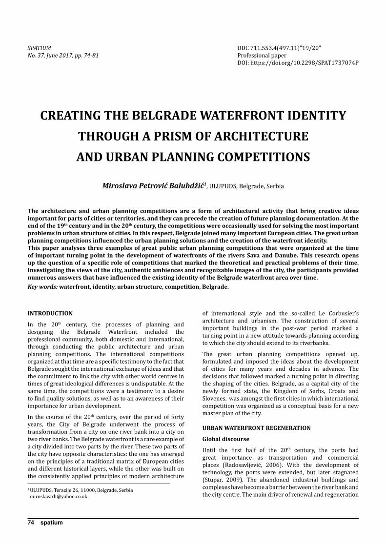
74 spatium
INTRODUCTION
In the 20th century, the processes of planning and designing the Belgrade Waterfront included the professional community, both domestic and international, through conducting the public architecture and urban planning competitions. The international competitions organized at that time are a specific testimony to the fact that Belgrade sought the international exchange of ideas and that the commitment to link the city with other world centres in times of great ideological differences is undisputable. At the same time, the competitions were a testimony to a desire to find quality solutions, as well as to an awareness of their importance for urban development.
In the course of the 20th century, over the period of forty years, the City of Belgrade underwent the process of transformation from a city on one river bank into a city on two river banks. The Belgrade waterfront is a rare example of a city divided into two parts by the river. These two parts of the city have opposite characteristics: the one has emerged on the principles of a traditional matrix of European cities and different historical layers, while the other was built on the consistently applied principles of modern architecture
of international style and the so-called Le Corbusier’s architecture and urbanism. The construction of several important buildings in the post-war period marked a turning point in a new attitude towards planning according to which the city should extend to its riverbanks.
The great urban planning competitions opened up, formulated and imposed the ideas about the development of cities for many years and decades in advance. The decisions that followed marked a turning point in directing the shaping of the cities. Belgrade, as a capital city of the newly formed state, the Kingdom of Serbs, Croats and Slovenes, was amongst the first cities in which international competition was organized as a conceptual basis for a new master plan of the city.
URBAN WATERFRONT REGENERATION
Global discourse
Until the first half of the 20th century, the ports had great importance as transportation and commercial places (Radosavljević, 2006). With the development of technology, the ports were extended, but later stagnated (Stupar, 2009). The abandoned industrial buildings and complexes have become a barrier between the river bank and the city centre. The main driver of renewal and regeneration
CREATING THE BELGRADE WATERFRONT IDENTITY THROUGH A PRISM OF ARCHITECTURE AND URBAN PLANNING COMPETITIONS
Miroslava Petrović Balubdžić1, ULUPUDS, Belgrade, Serbia
The architecture and urban planning competitions are a form of architectural activity that bring creative ideas important for parts of cities or territories, and they can precede the creation of future planning documentation. At the end of the 19th century and in the 20th century, the competitions were occasionally used for solving the most important problems in urban structure of cities. In this respect, Belgrade joined many important European cities. The great urban planning competitions influenced the urban planning solutions and the creation of the waterfront identity.This paper analyses three examples of great public urban planning competitions that were organized at the time of important turning point in the development of waterfronts of the rivers Sava and Danube. This research opens up the question of a specific role of competitions that marked the theoretical and practical problems of their time. Investigating the views of the city, authentic ambiences and recognizable images of the city, the participants provided numerous answers that have influenced the existing identity of the Belgrade waterfront area over time.Key words: waterfront, identity, urban structure, competition, Belgrade.
1 ULUPUDS, Terazije 26, 11000, Belgrade, Serbia [email protected]
UDC 711.553.4(497.11)”19/20”Professional paperDOI: https://doi.org/10.2298/SPAT1737074P
SPATIUM No. 37, June 2017, pp. 74-81

75spatium
of waterfront zones includes the need for opening the city to the river. The renewal and change of purpose imply the physical and functional transformations that will change the physiognomy of this part of the city, thus significantly influencing its visual identity. Today, due to the increasingly faster development of technology, new spaces for recreation, entertainment and culture are being sought, and they are located on the former edges of the city, the waterfront zones. The river banks represent a new chance for populists and a real possibility for developers. The culture of public open space is gaining increasing importance and role in the social integration and joint activities of different cultural groups.The reaffirmation of waterfront is today topical throughout the world. The process began already in the seventies of the 20th century (Radosavljević, 2006). It was preceded by the changes in economy, society and technology that brought about the changes in people’s needs. The technological progress brought the stagnation and reduction of port functions. This process first began in the Great Britain in the sixties of the 20th century, and then spread to other countries. Certain successful renewals have initiated a series of great urban projects all over the world. The waterfront renewal has become a way for the city to get new original buildings, attract investments and get people back to the abandoned areas. The waterfront renewal has generated its own discipline (Marshall, 2001).Belgrade as a concept of two river banks
The specificity of Belgrade lies in its exceptional geographic position and specific topography that make the city unique. In the second half of the 20th century, the rivers Sava and Danube were the borders between two empires, the Austro-Hungarian Monarchy and the Ottoman Empire. The city was frequently passed on from the Ottoman to Habsburg rule through wars. The territory on the hill where the historical core was formed, with its physical structure reflecting different patterns, as layers of time, is determined by the line of the river flow as a clear boundary at the confluence of the rivers Sava and Danube. The most important cityscape transformations took place after the abolition of borders on the rivers. This initiated ideas and plans for building Belgrade on the left bank of the Sava river. Shortly before the Second World War, in 1937, the Belgrade Fair complex was built. The new political conditions after the war changed the status of Belgrade. From the city on the hill, Belgrade became a capital city of a new federation, as a political, economic, cultural and administrative centre of the Federal People’s Republic of Yugoslavia. The need to form an administrative centre contributed to the decision to build a completely new part of the city on the left bank of the Sava (Đorđević, 1995). New Belgrade was built on the then latest principles of modernism in architecture. The Belgrade waterfront is characterized and shaped by the contrast of two different concepts of the city. The Master Plan of Belgrade 1950 promoted new goals, and one of the most important amongst them is that the Sava river, the former border and periphery to which the city has turned its back, has become a central motif of the city and, as such, it should represent a first-class factor in the
formation of a new image of the city (ibid.). The fact that the CIAM principles were to a great extent embedded in the attitudes, theory and practice of new Yugoslav architects was demonstrated when a design competition for the following large public buildings was announced in 1947: the building of the Central Committee of the Communist Party of Yugoslavia, the building of the Presidency of Government of the FPRY (Federal People’s Republic of Yugoslavia) and the building of a representative hotel. The concept is read through the recognizable orthogonal matrix of the New Belgrade blocks and the disposition of key buildings. It has essentially determined the current scheme of New Belgrade and influenced the development of the city as a whole (Bogdanović, 1986). The contemporary principles in the architecture of the completion designs reflected the latest tendencies in architectural creativity. The competition practically marked the beginning of works on the construction of New Belgrade on the left bank of the Sava. This was one of the greatest competitions in Yugoslavia. All of these important buildings were built in the waterfront area. This fact proves the belief that the post-war period was a turning point in the new attitude to planning the waterfront since the emergence of the tendency to open the face of the city to its rivers.The accelerated growth of the modern city on the left bank of the Sava, designed and built on uncompromising principles of modern architecture that developed fast and was realized in conditions of socialist economic system, was supported by industrial development of Yugoslavia after the Second World War. Today, the reflections about the renewal and reanimation of the right bank of the Sava river mainly include a series of different individual sites that should follow the existing parcels, also implying individual concepts of independent units in which a single urban landscape should be formed in a macro plan. On the other hand, there were reflections about the future development of Belgrade - the New Belgrade side, in which the issue of its function and shaping in new conditions, when there was a need for higher density of urban structure and more rational land use imposed itself as the most important issue.
TREATMENT OF THE WATERFRONT IN THE GREAT ARCHITECTURE AND URBAN PLANNING COMPETITIONS FOR BELGRADE
The vision of the waterfront development given in the 1922 International Competition for the Master Plan of Belgrade
The economic ambience after the First World War, in the period from 1919 to 1929, that spawned the Master Plan of Belgrade, was reflected in a rapid population growth and, at the same time, in a rapid progress of trade. After the First World War, Belgrade as the capital of Yugoslavia, had an important role as a political and economic centre, while the riverbanks became a prospective territory of the city (Мaksimović, 1983). The Competition was held in 1922. The second prize that was awarded to the master plan designed by an architect from Vienna included the left bank of the Sava. The first prize was not awarded, but three second prizes, out of which the work under the code “Singidunum Novissima” (by architects
Petrović Balubdžić M.: Creating the Belgrade Waterfront identity through a prism of architecture and urban planning competitions

76 spatium
Rudolf Perco, Ervin Ilz and Ervin Bock) represented a megalomanic aestheticized form that expressed the tendencies of the new Kingdom of Serbs, Croats and Slovenes (Blagojević, 2004). Almost unrealistically, the proposed physical structure extended over a large area on the right bank of the Sava river, and particularly on the left river bank.
According to the concept of the “Singidunum Novissima”, the banks of the rivers Sava and Danube should be built up to the very line of the river flow, particularly to the side towards the Danube, and the area should contain strictly regular conventional blocks. The area between the bank of the Sava and the rail tracks, in the parts called Bara Venecija (Venice Pond) and Savamala, were proposed for building the blocks. Only a strip of the former railway land covering a wide area was excluded. The efforts of the awarded master plan to extend the Savamala part of the city to the banks of the Sava are respectable considering that this was difficult to accomplish due to the existing rail tracks. The authors used compact blocks to emphasize the need for developing this area. This problem has remained unsolved to this day.
What is also important for this paper is the fact that the area on the left bank of the Sava (today the New Belgrade side) was treated in a plan for the first time. The authors proposed an extremely radical move, namely to dig a channel linearly through the terrain of the left bank of the Sava from the tip of the existing Ada Ciganlija island to the confluence of the rivers Sava and Danube, thus forming another big river island. A radical move concerning the linear channel would to a great extent change the image of the Bežanija fields (left bank of the Sava) and the existing and until then intact urban landscape at the confluence of two rivers. The bold engineering undertakings that characterized certain master plan designs indicate a great influence of trends in urban planning that existed in the then Europe. Considering the extensive works that this concept would require, it was not realized in the present conditions in spite of all praises it already won by being awared the second prize for the master plan design (the first placement). In spite of the high-quality and visionary solutions it offered, this master plan design was not embedded in future plans to a greater extent, partly because of the weak economic power that was disproportionate to the megalomanic conventional concepts of this master plan. On the other hand, this plan encountered resistance from the progressive Belgrade architects because of the powerful influence of modernism in architecture and urbanism that followed, and that was promoted at the first CIAM Congress in Switzerland held in 1928. This is the reason why this competition was forgotten in the early decades after the Second World War. The enthusiasm for new aesthetics of modern and international movements has also thrown into oblivion the useful proposals that would open new views in the old part of the city, as well as other useful proposals that would be appropriate to the old core of the city.
Undoubtedly, this competition was also very important as a cultural event in Belgrade. At the same time, it was a part of turbulent flows on the then architectural scene: on the one hand, it was a reflection of the European influences and principles of solving the conventional parts of the city based on the experiences of Neoclassicism and Neo-Baroque, and
on the other, it represented the penetration of new concepts of modern architecture, functioning of cities, Athens Charter, under the powerful influence of the architect Le Corbusier. The proposals for a radical reconstruction on the right bank of the Sava in the historical core of Belgrade recalls breakthroughs in the famous Haussmann’s plan for Paris (1852) (Stojanović, 2012), which is understandable given that it is a very remarkable example of planning and realization of the planning-based prediction of the future of an important European city such as Paris. This can represent a confirmation of the fact that economic growth in the new state provided the hope of a prosperous future, and gave the reason for the megalomania in the coverage, as well as for the surprising ambitions of this competition master plan design. However, although this competition was a bright spot in the Serbian urban history, it was abandoned and almost forgotten in the years to come. Obviously, the solutions that were typical for a conventional city, Belgrade, arrived with a delay of about half a century.
The Jury Report concluded that Zemun and Belgrade would be connected after building the bridges and wharfs. The issue of opening Belgrade to the left bank of the Sava was thus initiated for the first time. The Jury gave proposals for further work on the master plan based on the main awarded master plan designs (Maksimović, 1983).
Obviously, the remarks of the Jury speak in favour of the assumption that the first-placed master plan with its conventional composition came with delay concerning the issue of the development of the central zone of Belgrade. On the other hand, the proposals for interventions in the waterfront carry far bolder and more advanced ideas that have opened up new possibilities of the city’s relationship with the river banks.
Competition for the first public buildings in New Belgrade held in 1947
In 1947, an important task was set before the renowned Belgrade architects: the locations and programs for the most important buildings in Belgrade and Serbia had to be determined in a short time. The extensive works, speed and high quality of architecture of buildings were
Petrović Balubdžić M.: Creating the Belgrade Waterfront identity through a prism of architecture and urban planning competitions
Figure 1. International Competition for the Master Plan of Belgrade, the first-placed master plan design “Singidunum Novissima” from Vienna,
(Source: Der Städtebau (Berlin), 1922/23, Tafel 48)

77spatium
required. In such circumstances, one of the most important competitions for New Belgrade was announced in 1947. It was the Yugoslav public competition for conceptual designs of the buildings of the Central Committee of the Communist Party of Yugoslavia, Presidency of the Government of the FPRY and a representative hotel in New Belgrade (Macura,1995). In addition to the architecture of buildings, the competition requirements emphasized that the urban design was also required. The “Sketch for the regulation of Belgrade on the left bank of the Sava” - Figure 2, designed in 1946 by the architect Nikola Dobrović, was enclosed with the competition requirements. The Dobrović’s Sketch was based on the solutions for the road directions that determined the urban matrix of the new city. He positioned a new railway station in the centre, and also included new buildings for which the competition was announced. He based his concept on the modernist development of the city. The competition requirements treated the enclosed Sketch as tentative and non-binding. At the same time, the program of the competition announcement suggested that the basis for the urban plan should be the “commitment that New Belgrade should be conceived as an administrative centre of the Federation” (Tehnika, 1946).
The competition for the first public buildings in the still unbuilt New Belgrade significantly influenced the future directions, and, indirectly, the development of the city as a whole, too. The competition results put out of force the radial scheme of streets proposed in the competition announcement, which was previously proposed by the architect Nikola Dobrović (Figure 2). A great number of similar proposals by the participants, indicated that the orthogonal scheme should be used, according to which the urban matrix was conceived, and it has not been changed to this day. Prof. Bogdanović concluded that the competition master plan designs practically determined a new urban matrix that was simpler and more rational. (Bogdanović, 1986) Yet, bearing in mind the importance of river banks, Bogdanović opened a dilemma that the radial scheme proposed in the Dobrović’s Sketch would to a greater extent open the space of the new part of the city to the river.
Three second prizes were awarded for the Central Committee of the Communist Party of Yugoslavia building design. The prizes went to: Ravnikar from Ljubljana,
Dobrović from Belgrade and Segvić with Augustinčić from Zagreb. The first prize for the design of the building of the Presidency of Government was awarded to a group of architects: Potkonjak, Najman, Urlih and Perak from Zagreb (Macura,1995). The awarded designs, as well as the materialized buildings, had a great influence on further development of modern architecture in the country. The representative hotel designed by the architect I. Horvat from Zagreb was built on the bank of the river Danube. The hotel is an example of high-quality architecture in the spirit of modernism. The supreme architecture in the country developed in conditions of the new social system, the new ideology. It is particularly interesting to emphasize that a great number of very important buildings were built, or at least only planned, in the immediate vicinity of the waterfront.
The possibility of the competition visions to influence the creation of the waterfront identity became evident on the examples of these great competitions from 1947. As Blagojević (2004) concluded, the previous Sketch designed by Nikola Dobrović was offered to the contestants only tentatively. The contestants were also invited to develop an urban plan for New Belgrade in addition to their proposals for buildings. Instead of Dobrović’s railway station in the centre of a radial urban matrix, the competition practically directed the development of New Belgrade to the construction of its first building. It was the building of the Presidency of the Government of the FPRY.
Considering the difference between the radial urban matrix scheme proposed by Dobrović in his Sketch from 1946 and the awarded competition master plan designs that proposed the orthogonal urban matrix scheme, as well as the mentioned conclusion that there was a clear commitment to the concept of New Belgrade as the centre of the Federation administration, it can be concluded that the competition requirements directed contestants to choose the solutions that bring in the fore the idea of an administration centre (centre of the Federation - FPRY) with dominating buildings of the Federation instead of a functionalist concept with the railway station. The Jury thus made an important shift in the
Petrović Balubdžić M.: Creating the Belgrade Waterfront identity through a prism of architecture and urban planning competitions
Figure 2. Preliminary Land Use Plan for Belgrade 1946, Nikola Dobrović (Source: Urbanistic Institute of Serbia, Belgrade, 1946)
Figure 3. The Federal Executive Council building (Source: Source: Journal Arhitektura Urbanizam, No. 2, 1960)
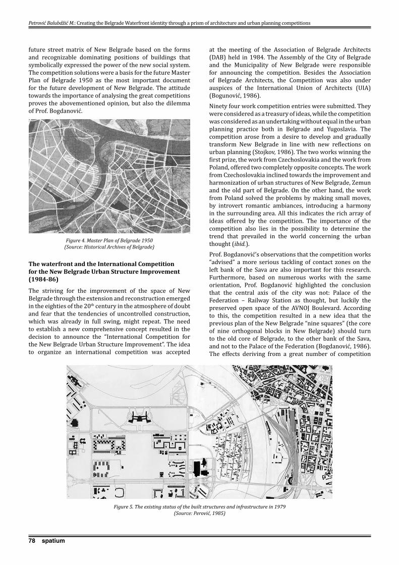
78 spatium
Petrović Balubdžić M.: Creating the Belgrade Waterfront identity through a prism of architecture and urban planning competitions
future street matrix of New Belgrade based on the forms and recognizable dominating positions of buildings that symbolically expressed the power of the new social system. The competition solutions were a basis for the future Master Plan of Belgrade 1950 as the most important document for the future development of New Belgrade. The attitude towards the importance of analysing the great competitions proves the abovementioned opinion, but also the dilemma of Prof. Bogdanović.
The waterfront and the International Competition for the New Belgrade Urban Structure Improvement (1984-86)
The striving for the improvement of the space of New Belgrade through the extension and reconstruction emerged in the eighties of the 20th century in the atmosphere of doubt and fear that the tendencies of uncontrolled construction, which was already in full swing, might repeat. The need to establish a new comprehensive concept resulted in the decision to announce the “International Competition for the New Belgrade Urban Structure Improvement”. The idea to organize an international competition was accepted
at the meeting of the Association of Belgrade Architects (DAB) held in 1984. The Assembly of the City of Belgrade and the Municipality of New Belgrade were responsible for announcing the competition. Besides the Association of Belgrade Architects, the Competition was also under auspices of the International Union of Architects (UIA) (Bogunović, 1986).Ninety four work competition entries were submitted. They were considered as a treasury of ideas, while the competition was considered as an undertaking without equal in the urban planning practice both in Belgrade and Yugoslavia. The competition arose from a desire to develop and gradually transform New Belgrade in line with new reflections on urban planning (Stojkov, 1986). The two works winning the first prize, the work from Czechoslovakia and the work from Poland, offered two completely opposite concepts. The work from Czechoslovakia inclined towards the improvement and harmonization of urban structures of New Belgrade, Zemun and the old part of Belgrade. On the other hand, the work from Poland solved the problems by making small moves, by introvert romantic ambiances, introducing a harmony in the surrounding area. All this indicates the rich array of ideas offered by the competition. The importance of the competition also lies in the possibility to determine the trend that prevailed in the world concerning the urban thought (ibid.).Prof. Bogdanović’s observations that the competition works “advised” a more serious tackling of contact zones on the left bank of the Sava are also important for this research. Furthermore, based on numerous works with the same orientation, Prof. Bogdanović highlighted the conclusion that the central axis of the city was not: Palace of the Federation – Railway Station as thought, but luckily the preserved open space of the AVNOJ Boulevard. According to this, the competition resulted in a new idea that the previous plan of the New Belgrade “nine squares” (the core of nine orthogonal blocks in New Belgrade) should turn to the old core of Belgrade, to the other bank of the Sava, and not to the Palace of the Federation (Bogdanović, 1986). The effects deriving from a great number of competition
Figure 4. Master Plan of Belgrade 1950 (Source: Historical Archives of Belgrade)
Figure 5. The existing status of the built structures and infrastructure in 1979 (Source: Perović, 1985)

79spatium
Petrović Balubdžić M.: Creating the Belgrade Waterfront identity through a prism of architecture and urban planning competitions
concepts indicate the strengthening of the contact between the old and the new city including the contact zones of the river banks. The competition works unambiguously indicated that the physical structure of two banks of the Sava should be shaped as a synthesis and that it should allow a maximum communication in the visual and functional stretches.
The first-awarded work from Bratislava by Jaroslav Kachlik was characterized by the Jury’s report as a concept that offers an optimum integration of the city with all of its parts from Zemun to the hinterland of the old Belgrade. A new centre of Belgrade on the Sava, on the very river bank between the railway station and New Belgrade, was the main new element. By introducing the new directions for the purpose of integrating the space, this concept contained a series of interesting and attractive ideas for the contact area between the city and the Sava, as well as for a visual and functional linking of the Kalemegdan Terrace to New Belgrade, thus introducing a new potential direction emphasizing a new connection over the river to kalemegdan as a provocation. The Jury report concluded that this work was an excellent starting point for planning and shaping New Belgrade, thus also for the future of Belgrade in general (Stojkov, 1986). By implementing the idea of integrating the two river banks, this work introduced new directions for passengers, but also new bridges.
The first-awarded work from Warsaw, by Domaradski, Dziekonski and Garbowski, was characterized as a work that provides a rich and humane environment for the future of New Belgrade. The work envisaged new activities along the existing large streets and a new park on stretch: the Federal Executive Council building – railway station. The work directed the development almost entirely to the Sava Amphitheatre, the waterfront on the right bank of the Sava, turning the faces of Belgrade and New Belgrade to each other.
It could be said that the competition was organized in the period of stagnation and glutted with ideas of modernist architecture, so that works revealed the influence of the postmodernist discourse that followed as response to the problems brought by modernist principles.
The competition activities in developing the right and left banks of the Sava by 2016
After the 1986 competition, the significant changes took place in the political and economic system, while wars that caused the dissolution of Yugoslavia brought problems. This has contributed to an increased uncontrolled construction and increased unplanned construction activities in the city, so that today, in addition to once clear concept of modernist architecture of New Belgrade, we are also witnesses of a new development that is disturbing the existing spirit of the place. The processes of urban transformations in New Belgrade have created a different city which is no longer built on the principles of humanism and social equality, but a city which is, on the wings of neoliberal capitalism, getting “new neighbourhoods” with which it fills empty spaces. The new development represents “a new strategy and ideology of Serbian turbo-capitalism, economy based on the sale of national wealth,...on dominance of corporate power over the state, and on excessive consumption.” (Dimitrijević, 2009).
In the early 21th century, there was an increasing interest in, but also the need for developing the Belgrade waterfront. An architecture and urban planning competition for the Block 18 on the left bank of the Sava, the New Belgrade side, was announced in 2016. The location in New Belgrade that was an imagined connection to the Sava Amphitheatre got a chance to be developed as a new contemporary part of the city.
The Sava Amphitheatre on the right bank of the Sava, traditionally considered as one of the main resources of Belgrade for many years now, has become a place of many social and cultural activities, but also a subject of the planning activities of different study groups that have continued reflecting on the development and visual connection between the left and the right river banks as an expression of aspiration to open the city to the river.
Promoted in 2014, as a future plan for the development of the Sava Amphitheatre, also including the traditional part of the city in the contact zone known as Savamala, the Belgrade Waterfront Project was presented to the general public as an already completed project. However, the location of exceptional importance, based on which
Figure 6. International Competition for the New Belgrade Urban Structure Improvement, joint first prize, Czechoslovakia
(Source: Journal Arhitektura Urbanizam, special issue, 1986)
Figure 7. International Competition for the New Belgrade Urban Structure Improvement, joint first prize, Poland
(Source: Journal Arhitektura Urbanizam, special issue, 1986)

80 spatium
Petrović Balubdžić M.: Creating the Belgrade Waterfront identity through a prism of architecture and urban planning competitions
concept a future urban identity of Belgrade depends, must be conceived and planned through an architecture and urban planning competition. This is the only legitimate way to verify the CONCEPT through knowledge and experiences of the profession. Numerous appeals of professional associations have remained unanswered: The solutions for the development of the part of Belgrade along the Sava river should be selected at republic or international competition, as the Association of Architects of Serbia insists (Marić, 2014). In the professional journal Izgradnja, the architect Branko Bojović emphasizes the fact that the initiative concerning the Belgrade Waterfront Project is “dilettantism as urbanism” and that it has been developed in a semi-hidden way without qualified professional information (Bojović, 2014). The professional association, the Academy of Architecture of Serbia, has published “Declaration on the Belgrade Waterfront” addressing the institutions of Serbia, Belgrade, professional community and the wider public. The Declaration emphasizes that the Belgrade Waterfront Project is imposed in an inadequate way and points out the humiliating fact that one scale model that does not bear the name of the author has become the main matrix for developing the spatial plan (Declaration on the Belgrade Waterfront, 2015). Architect Kovačević appeals and warns that the damage and consequences of such a project will be far-reaching and irreversible (Kovačević, 2015).
CONCLUSIONS
The Belgrade waterfront identity is essentially linked to the fate of the urban structure of the city. In the 20th century, the urban landscape of the Belgrade waterfront underwent radical changes that turned the city centre towards the rivers, so that the processes striving to connect the river banks and the central zones of the city are still on-going. The city centre has been gradually moved to the waterfront, thus strengthening the links between the old and new parts of the city. The competition activities that started at the beginning of the 20th century were necessary as a previous study that influenced the later decisions on the further planned development of the city. At the same time, this was the way to encourage the local professional community to openly reflect on the space of the city and to check their reflections through foreign experiences. The plans that followed used the ideas from the completion solutions. They have been discussed and decisions on the space have been made based on them. Although the competition solutions have not been consistently implemented, they have contributed to the sharpened reflections within the given programs. Due to the political and economic problems, they have determined the direction of the city’s development without including the competition solutions to a greater extent. As for the competition solutions, the fierce competition and publicity in work contributed to the formation of new concepts. Thus, the 1922 competition affirmed the ideas about the development of the left bank of the Sava and partly directed the decisions related to the old part of the city. The 1947 competition for positioning the important buildings contributed to a radical change in the New Belgrade urban matrix, which was important for the contact zone of the
waterfront and connection with the old Belgrade. The competition proposals from 1986 were considered as a treasury of ideas that indicated the possible solutions to the problems of New Belgrade. They considerably treated the contact zone of the two banks of the Sava. The results of the 1986 competition were published in a special issue of the journal “Arhitektura Urbanizam”. On this occasion, a professional discussion was organized and the collection of competition works was published. The enthusiasm and the competition procedure is an example of how to act today when it comes to the locations of great importance for the city. Contrary to the rise of the post-war modernism on the left bank of the Sava river, the current technological development is not keeping the pace with the development and renewal of the right bank of the Sava river in a way that would be in accordance with foreign experiences and with the needs of the city. Due to the political and economic circumstances in the country undergoing transition and the new neo-liberal economy in this region, the important progress in the comprehensive planning concepts of space has not been achieved. The potential mechanisms that should be set in motion through partnership of the private capital and government instruments are present only in partial actions. The professional community is not adequately included in the decision making process on space, so that direct interest of capital has the exclusive right. The non-developed, neglected parts of the city have become sites for alternative and temporary solutions, which actively indicates the spatial problems. In search for potential development of all neglected, but representative sites in the Belgrade Waterfront, it appears that the investigation of documentation on the large architecture design competitions can bring some precious pieces of information and point to the need for a transparent and creative planning. Amongst the analysed competitions, the 1947 competition had the greatest influence on planning as a basis for drawing up the Master Plan in 1950, as well as a decisive influence on the formation of the New Belgrade urban matrix. The selected competition designs have also determined the main directions that today link the two banks of the Sava river by bridges. On the other hand, the right bank of the Sava river is a specific potential which is not yet sufficiently used, this being a special challenge today. Nowadays, the dominating transition processes and a new neo-liberal discourse that emphasize the importance of investor’s intentions have unjustifiably distanced the professional architectural community from urbanism and architecture as a creative act and as the only instrument that could contribute to the future Belgrade Waterfront identity.
REFERENCES
Blagojević, Lj. (2004) Strategije modernizma u planiranju i projektovanju urbane strukture i arhitekture Novog Beograda: period konceptualne faze od 1922. do 1962. godine (doktorska disertacija). Beograd: Arhitektonski fakultet Univerziteta u Beogradu. [Blagojević, Lj. (2004) Strategies of modernism in planning and design of urban structure and architecture of New Belgrade: period of conceptual stage from 1922 to 1962 (doctoral dissertation). Belgrade: Faculty of Architecture, University of Belgrade.]
81spatium
Bogdanović, B. (1986) Budućnost Novog Beograda, Međunarodni konkurs za unapređenje urbane strukture Novog Beograda, Arhitektura Urbanizam, specijalno izdanje, pp. 3-13. [Bogdanović, B. (1986) The Future of New Belgrade, International Competition for the New Belgrade Urban Structure Improvement, Arhitektura Urbanizam, special issue, pp. 3-13.]
Bogunović, U. (1986) Budućnost Novog Beograda, Međunarodni konkurs za unapređenje urbane strukture Novog Beograda, Arhitektura Urbanizam, specijalno izdanje, pp. 3-13. [Bogunović, U. (1986) The Future of New Belgrade, International Competition for the New Belgrade Urban Structure Improvement, Arhitektura Urbanizam, special issue, pp. 3-13.]
Bojović, B. (2014) Pogledi i mišljenja, Beograd na vodi - diletantizam kao urbanizam, Izgradnja, No.68, pp. 3-4 and pp. 167-168. [Bojović, B. (2014) Views and opinions, Belgrade Waterfront - dilettantism as urbanism, No.68, Izgradnja, No.68, pp. 3-4 and pp. 167-168.]
Declaration on “the Belgrade Waterfront” (2015) / Deklaracija o “Beogradu na vodi”, http://aas.org.rs/wp-content/uploads/2015/03/Deklaracija-AAS-o-Beogradu-na-vodi-05.-mart-2015..pdf, accessed 15th May 2017.
Dimitrijević, A. (2009) The brave new neighbourhoods of New Belgrade, in Erić, Z. (ed.) Differentiated Neighbourhoods of New Belgrade, Project of the centre for visual culture at MOCAB, Belgrade: Museum of Contemporary Art, pp. 116-119.
Đorđević, A. (1995) Urbanistički razvoj Beograda od 1944. do 1980. godine, in Tasić N. et al. (eds.) Istorija Beograda, Beograd: Srpska akademija nauka i umetnosti, Balkanološki institut “Draganić”, pp. 551-552. [Đorđević, A. (1995) Urban development of Belgrade from 1944 to 1980, in Tasić N. et al. (eds.) History of Belgrade, Belgrade: Institute for Balkan Studies “Draganić”, pp. 551-552].
Janković, M. (1960) Zgrada Saveznog izvršnog veća na Novom Beogradu, Arhitektura urbanizam, No. 2, pp.13-15. [Janković, M. (1960) Building of the Federal Executive Council in New Belgrade, Arhitektura urbanizam, No. 2, pp.13-15.]
Kovačević, B. (2015) Greške u urbanizmu su večne, http://aas.org.rs/greske-u-urbanizmu-su-vecne-ili-katastrofalno-skupe, accessed 10th March, 2015. [Kovačević, B. (2015) Errors in urban planning are eternal, http://aas.org.rs/greske-u-urbanizmu-su-vecne-ili-katastrofalno-skupe, accessed 10th March, 2015.]
Macura, M. (1995) Arhitektura Beograda od 1944-1975. godine, in Tasić N. et al. (eds.) Istorija Beograda, Beograd: Srpska akademija nauka i umetnosti, Balkanološki institut “Draganić”, pp. 571-572. [Macura, M. (1995) Belgrade architecture in the period 1944-1975, in Tasić N. et al. (eds.) History of Belgrade, Belgrade: Institute for Balkan Studies “Draganić”, pp. 571-572.]
Maksimović, B. (1983) Ideje i stvarnost urbanizma Beograda: 1830-1941. Beograd: Zavod za zaštitu spomenika kulture grada Beograda. [Maksimović, B. (1983) Ideas and Reality of Belgrade Urbanism. Belgrade: Institute for the Protection of Cultural Monuments of Belgrade.]
Marić, I. (2014) “Beograd na vodi”, Na koji način, http://www.u-a-s.rs/item/73-%D0%B1%D0%B5%D0%BE%D0%B3%D1%80%D0%B0%D0%B4-%D0%BD%D0%B0-%D0%B2%D0%BE%D0%B4%D0%B8.html, accessed 17th Jan 2014. [Marić, I. (2014) “Belgrade on the water”, In what way, http://www.u-a-s.rs/item/73-%D0%B1%D0%B5%D0%BE
%D0%B3%D1%80%D0%B0%D0%B4-%D0%BD%D0%B0-%D0%B2%D0%BE%D0%B4%D0%B8.html, accessed 17th Jan 2014.]
Marshall, R. (2001) Waterfronts in Post-Industrial Cities. London, New York: Spon Press.
Perović, R. M. (1985) Iskustva prošlosti. Beograd: Zavod za planiranje razvoja grada Beograda. [Perović, R. M. (1985) Experiences of the Past, Belgrade: Institute for Planning the Development of the City of Belgrade.]
Radosavljević, U. (2006) Beograd Prestonica - Grad reka / Beograde the Capital - City of Rivers, Faculty of Architecture, University of Belgrade, Berlage Institute Rotterdam, Fakultat fur Architektur der RWTH Aachen, p. 321.
Stojanović, D. (2012) Kaldrma i asfalt, Urbanizacija i Evropeizacija Beograda od 1890-1914. Beograd: Udruženje za društvenu istoriju. [Stojanović, D. (2012) The Paving Stones and Asphalt, Urbanisation and Europeanisation of Belgrade from 1890-1914. Belgrade: Association for Social History.]
Stupar, A. (2009) Grad Globalizacije- izazovi, transformacije, simboli - prostori urbanog identiteta. Beograd: Orion art. [Stupar, A. (2009) City of globalization – challenges, transformations, symbols – spaces of urban identity. Belgrade: Orion art.]
Stojkov, B. (1986) Budućnost Novog Beograda, Međunarodni konkurs za unapređenje urbane strukture Novog Beograda, Arhitektura Urbanizam, posebno izdanje, pp. 12-13. [Stojkov, B. (1986) The Future of New Belgrade, International Competition for the New Belgrade Urban Structure Improvement, Arhitektura Urbanizam, special issue, Belgrade, pp. 12-13.]
Uslovi konkursa za zgradu Centralnog komiteta Komunističke partije Jugoslavije i za zgradu Predsedništva vlade Federativne narodne republike Jugoslavije (1946) Tehnika, No. 11-12, p. 341. [Conditions of the competition for the building of the Central Committee of the Communist Party of Yugoslavia and for the building of the Presidency of the Government of the Federal People’s Republic of Yugoslavia (1946) Tehnika, No. 11-12, p. 341.]
Vuksanović-Macura, Z. (2015) San o gradu –Međunarodni konkurs za urbanističko uređenje Beograda 1921-1922. Beograd: Orion Art. [Vuksanović-Macura, Z. (2015) Dream of the City – International Competition for Urban Development of Belgrade 1921-1922. Belgrade: Orion Art.]
Petrović Balubdžić M.: Creating the Belgrade Waterfront identity through a prism of architecture and urban planning competitions
Received December 2016; accepted in revised form June 2017.


spatium
SPATIUM Instructions to AuthorsSubmission of manuscriptsManuscripts must be submitted in English, and must be original, unpublished work not under consideration for publication elsewhere. Authors should submit their manuscript as an e-mail attachment to the Journal’s Editorial: [email protected], Institute of Architecture and Urban & Spatial Planning of Serbia, Bulevar kralja Aleksandra 73/II, 11000 Beograd, Serbia, telephone: +381 11 3207 300, fax: +381 11 3370 203. Contact persons are: Miodrag Vujošević, Editor-in-Chief (email: [email protected]) and Tanja Bajić, Technical Editor (email: [email protected]).Clearly written, concise manuscripts should comprise:
• a concise and informative title;• the full names and affiliations of all authors;• the full mailing address, e-mail address, telephone and fax numbers of the corresponding author;• a concise and informative abstract of 200 words maximum summarising the significant points of the paper, and up to five keywords following the abstract.
The size of manuscripts should be between 3,500 - 5,000 words. Please use Times New Roman font ranging from 10-12 point depending on what is the most convenient for you. Chapters should be numbered consecutively, e.g. 1. Introduction; followed by according numeration of subchapters (e.g. 1.1, 1.2, etc.). The use of footnotes or endnotes in manuscripts is not welcome. Only in case of absolute necessity, the maximum number of footnotes/endnotes per manuscript that could be tolerated is 5. Either British or American spelling is acceptable. Please pay attention in particular to consistency, i.e. do not mix different spellings. Manuscripts should be submitted as Word 97-2003 Document (.doc file).The manuscript will be subject to blind review. Revisions may be required before a decision is made to accept or reject the paper. Please ensure that all accompanying matter (tables, figures, photographs, necessary permissions and contact details) are enclosed as directed in these Instructions. Please use maximum of 10 illustrations (tables, figures, photographs) within the manuscript you submit.ReferencesPapers should be supported by references where appropriate and set out in accordance with the Harvard style as detailed below. Papers submitted with references in the wrong style will be returned. It is the authors’ responsibility to check the accuracy of references. References in the text should be cited as follows:
• one author: Lang (1994) or (Lang, 1994)• two authors: Smith and Brown (1993) or (Smith and Brown, 1993)• three or more authors: Lee et al. (1991) or (Lee et al., 1991)
Papers by the same author(s) in the same year should be distinguished by the letters a, b, etc. References should be listed at the end of the paper in alphabetical order giving the year of publication, title of paper, journal titles in full, volume and issue number, and first and last page numbers. References to books should include their edition, editor(s), publisher and place of publication.Examples:
• BookLang, J.T. (1994) Urban design: the American experience. New York: Van Nostrand Reinhold.
• Edited bookVujošević, M., Nedović-Budić, Z. (2006) Planning and societal context – The case of Belgrade, Serbia, in Tsenkova, S. and Nedović-Budić, Z. (eds.) Urban Mosaic of Post-Socialist Europe: Space, Institutions and Policy. Heidelberg: Springer, pp. 275-293.
• JournalJackson, T., Illsley, B. (2008) Using SEA to mainstream sustainable development: Some lessons from Scottish practice, SPATIUM, No. 17-18, pp. 31-37. If available, the number of volume should also be included here.
• Legal acts (laws, by-laws, etc.)Planning and Construction Act / Zakon o planiranju i izgradnji (2009) Službeni glasnik Republike Srbije 72/2009.
• Development and related actsDevelopment Strategy of the Republic of Serbia / Strategija razvoja Republike Srbije (2010) Vlada Republike Srbije, Beograd.
• Reference websites, online sourcesReferences to websites and other online sources should give authors if known, the publisher date if known, the title of the cited page, the URL in full, who the site is maintained by, and the date the page was accessed.Example:Cyburbia - The planning community, http://www.cyburbia.org/, accessed 22nd Apr 2009.
The references, which are cited in languages other than English, should in parallel be translated into English. Tables, illustrations, figures and photographsIdeally illustrations, photographs should be submitted electronically in TIFF or JPEG formats. High resolution black and white images (at least 300 dpi) should be used for the best quality reproduction. The approximate position of the tables and figures should be indicated in the manuscript (e.g. Table 1, Figure 1). The font used for labelling should be no smaller than 8 points.ConventionsAll measurements should be in metric units, or state metric equivalents. Abbreviations should be defined in brackets after their first mention in the text in accordance with internationally agreed rules.CopyrightAuthors are responsible for obtaining permission from copyright holders for reproducing through any medium of communication those illustrations, tables, figures or lengthy quotations previously published elsewhere. Credit the source and copyright of photographs or figures in the accompanying captions. Other acknowledgements could be added in a special section at the end of the paper. No contribution will be accepted which has been published elsewhere, unless it is expressly invited or agreed by the Publisher. Papers and contributions published become the copyright of the Publisher, unless otherwise agreed.ProofsThe corresponding author will be sent an e-mail containing PDF proof of the article. Please print a copy of the PDF proof, correct within the time period indicated and return as directed. Please make no revisions to the final, edited text, except where the copy-editor has requested clarification. ChargesThere are no article submission charges or article processing charges.


spatium
CIP – Katalogizacija u publikaciji Narodna biblioteka Srbije, Beograd
71/72
SPATIUM : urban and spatial planning, architecture, housing, building, geodesia, environment / editor in chief Miodrag Vujošević. - 1997, no. 1 (sept.)- . - Belgrade : Institute of Architecture and Urban & Spatial Planning of Serbia, 1997- . - 29 cm
Polugodišnje
ISSN 1450-569X = Spatium (Belgrade)
COBISS.SR-ID 150289159