spdo: high-throughput road distance … high-throughput road distance computations on spark using...
TRANSCRIPT

SPDO: High-Throughput Road Distance Computations on Spark Using Distance Oracles
ICDE 2016
Shangfu Peng
[email protected] University of Maryland
Spatial Tek LLC
Jagan Sankaranarayanan Hanan Samet
[email protected] NEC Labs America
[email protected] University of Maryland
Spatial Tek LLC

What do we do? Motivation: Need to compute millions of network distances or trip times per second on a road network
Motivation: Need to compute millions of network distances or trip times per second on a road network

Who needs such computations?
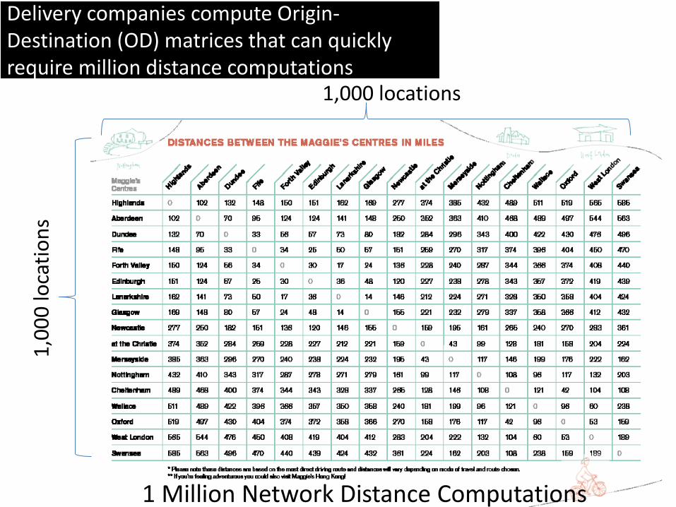
1,000 locations
1 Million Network Distance Computations
Delivery companies compute Origin-Destination (OD) matrices that can quickly require million distance computations
Delivery companies compute Origin-Destination (OD) matrices that can quickly require million distance computations
1,0
00
loca
tio
ns

Uber has 35,000 taxis in NYC and need to process customer requests, analyze GPS track etc.
Uber has 35,000 taxis in NYC and need to process customer requests, analyze GPS track etc.

Local Advertisement companies need to serve ads to people that are both proximal and can reach the customer business, need to do that at say 10K impressions a second!
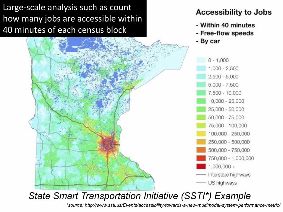
State Smart Transportation Initiative (SSTI*) Example *source: http://www.ssti.us/Events/accessibility-towards-a-new-multimodal-system-performance-metric/
Large-scale analysis such as count how many jobs are accessible within 40 minutes of each census block
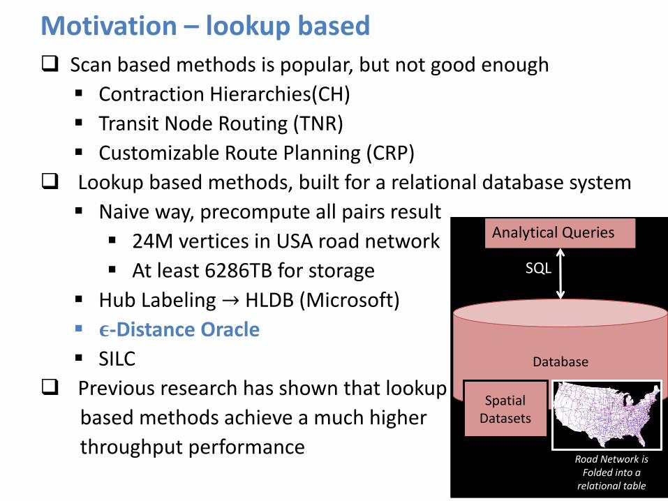
Motivation – lookup based
Database Database
Spatial Datasets Spatial
Datasets
Analytical Queries
SQL
Road Network is Folded into a
relational table
Scan based methods is popular, but not good enough
Contraction Hierarchies(CH)
Transit Node Routing (TNR)
Customizable Route Planning (CRP)
Lookup based methods, built for a relational database system
Naive way, precompute all pairs result
24M vertices in USA road network
At least 6286TB for storage
Hub Labeling → HLDB (Microsoft)
𝛜-Distance Oracle
SILC
Previous research has shown that lookup
based methods achieve a much higher
throughput performance

Motivation – distributed key-value store High throughput → Distributed system
Lookup based methods → Key-value data structure → hash access
We need to adapt distance oracles for distributed architecture Test on RDBMS shows that we cannot scale more than 60K queries/per core
Need to scale to even higher throughputs, using Apache Spark
IndexedRDD
Queries
Workload Partition
Gateway Machine
Graph and datasets are copied M times
Task Machine 2
Algorithm
Datasets
… …
Queries
Master
Spark Cluster
Graph
Task Machine M
Algorithm
Datasets
Graph DISTANCE ORACLE
Loaded in distributed memory
(a) Existing distributed solution (b) SPDO
Task Machine 1
Algorithm
Datasets
Graph

Method - 𝝐-Distance Oracle (𝝐-DO)
A compression representation of road network distances
Well-separated pair decomposition (WSPD) on a road network
Can represent the distance between any two points in A and B by one value with an epsilon error tolerance, e.g., 0.25, 0.1, 0.05
𝑂
𝑛
𝜖2 well-separated pairs, each well-separated pair can be
represented as a key-value pair
Key is the pair of two vertex sets, A and B
Value is 𝑑𝐺(𝑝𝐴, 𝑝𝐵)
A B 𝑝𝐴 𝑝𝐵 … …
𝑑𝑢𝑚𝑏𝑏𝑒𝑙𝑙 structure

Method - DO-Tree
Top-down decomposition on the whole space, (𝑆, 𝑆)
PR-Quadtree, Morton code representation
(𝑆, 𝑆) => (0, 0)
0
2 3
0 1 10 11
8 9
14 15
12 13
2 3
0 1
6 7
4 5
Depth 0
Depth 1
Depth 2
2-dimensional Morton code
(0, 0)
(𝟎, 0) (𝟑, 𝟑)
16 branches
Depth 1
Depth 2
MAX Depth 𝐷
… … Depth 3
(𝟎,𝟏) … …
… … (𝒔𝒊, 𝒕𝒋−𝟏) (𝒔𝒊, 𝒕𝒋) (𝒔𝒊, 𝒕𝒋+𝟏)
4-dimensional DO-tree

Method - DO-Tree
DO-tree = the top-down WSPD
Each leaf node of DO-tree is a well-separated pair
Uniqueness Property: For any source-target query (𝑠, 𝑡), there is exactly one leaf node of the DO-tree, i.e., WSP that contains both 𝑠 and 𝑡.
Task: for any query (𝑠, 𝑡), finding the exact one WSP that contains 𝑠, 𝑡 by hash access, then returning the distance result
(0, 0)
(𝟎, 0) (𝟑, 𝟑)
16 branches
Depth 1
Depth 2
MAX Depth 𝐷
… … Depth 3
(𝟎,𝟏) … …
… … (𝒔𝒊, 𝒕𝒋−𝟏) (𝒔𝒊, 𝒕𝒋) (𝒔𝒊, 𝒕𝒋+𝟏)

Method - Hash Access for 𝝐-DO
Basic idea (Basic)
Hash Table 𝑯𝟏 = all leaf nodes (WSPs) of DO-tree
Each query (𝑠, 𝑡) generates 𝑂(𝐷) keys, each key corresponds one ancestor node of (𝑠, 𝑡)
Exact one key exists in 𝑯𝟏 according to the uniqueness property
Oracle Part 1
Oracle Part 2
Oracle Part 𝑀
𝑵 s-t queries
𝑵 × 𝑫 keys
Master Node
… …
Hash Partitioner
Node 1
Node 2
Node 𝑀
Hash Access
Result Collector
In-memory
… … 𝑀 Slaves
Nodes
Network Communication Scatter Gather

Method - Hash Access for 𝝐-DO
Binary search method (BS)
Hash Table 𝑯𝟐 = all nodes of DO-tree, {𝑟𝑜𝑜𝑡, (𝐴, 𝐵), (𝐶, 𝐸)}
For any query (𝑠, 𝑡), initial possible depth range is [1, D]
Examining if the ancestor node of (𝑠, 𝑡) at depth 𝐷/2 exists in 𝑯𝟐 or not
Possible depth range becomes
either [0, 𝐷/2) or [𝐷/2, D]
WSP
(𝑨, 𝑩)
root
Existent
Inexistent
(𝑪, 𝑬)
(𝒔, 𝒕)
(𝑭, 𝑮)
Depth 1
Depth 2
MAX Depth 𝐷
Depth 3
Depth 4

Method - Hash Access for 𝝐-DO
Binary search method (BS)
Hash Table 𝑯𝟐 = all nodes of DO-tree, {𝑟𝑜𝑜𝑡, (𝐴, 𝐵), (𝐶, 𝐸)}
Note that O(log 𝐷) = 𝑂(log log 𝑛)
Wise Partitioning method (WP)
Adding spatial partitioning
of all nodes, push 𝑂(log 𝐷)
hash lookups in Slaves
AFOracle Part 1
AFOracle Part 2
AFOracle Part 𝑀
𝑵 s-t queries
𝑵 keys
Master Node
𝑀 Slaves Nodes
… …
Hash Partitioner
Node 1
Node 2
Node 𝑀
Hash Access
Result Collector
In-memory
Finish 𝐥𝐨𝐠 𝑫 iterations
Less than 𝐥𝐨𝐠 𝑫
iterations
… …
Network Communication Scatter Gather
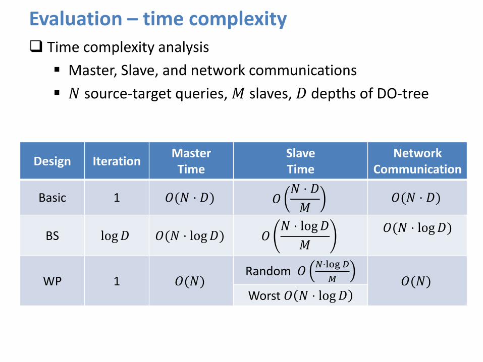
Evaluation – time complexity Time complexity analysis
Master, Slave, and network communications
𝑁 source-target queries, 𝑀 slaves, 𝐷 depths of DO-tree
Design Iteration Master Time
Slave Time
Network Communication
Basic 1 𝑂(𝑁 ⋅ 𝐷) 𝑂𝑁 ⋅ 𝐷
𝑀 𝑂(𝑁 ⋅ 𝐷)
BS log 𝐷 𝑂(𝑁 ⋅ log 𝐷) 𝑂𝑁 ⋅ log 𝐷
𝑀
𝑂(𝑁 ⋅ log 𝐷)
WP 1 𝑂(𝑁) Random 𝑂
𝑁⋅log 𝐷
𝑀
𝑂(𝑁) Worst 𝑂 𝑁 ⋅ log 𝐷

Evaluation - throughput Comparisons
Dijkstra’s algorithm (Dijkstra), good for one-to-many pattern
Contraction hierarchies (CH)
Distance Oracle embedded in PostgreSQL (DO)
• NYC road network • 264K vertices, 733K edges • One local server, single-thread
• USA road network • 24M vertices, 58M edges • 20 machines cluster, single-thread
Method Basic BS WP DO CH Dijkstra
Dist/sec/machine 5.0K 25.0K 73.8K 18.8K 385 1.6
Throughput the USA road network
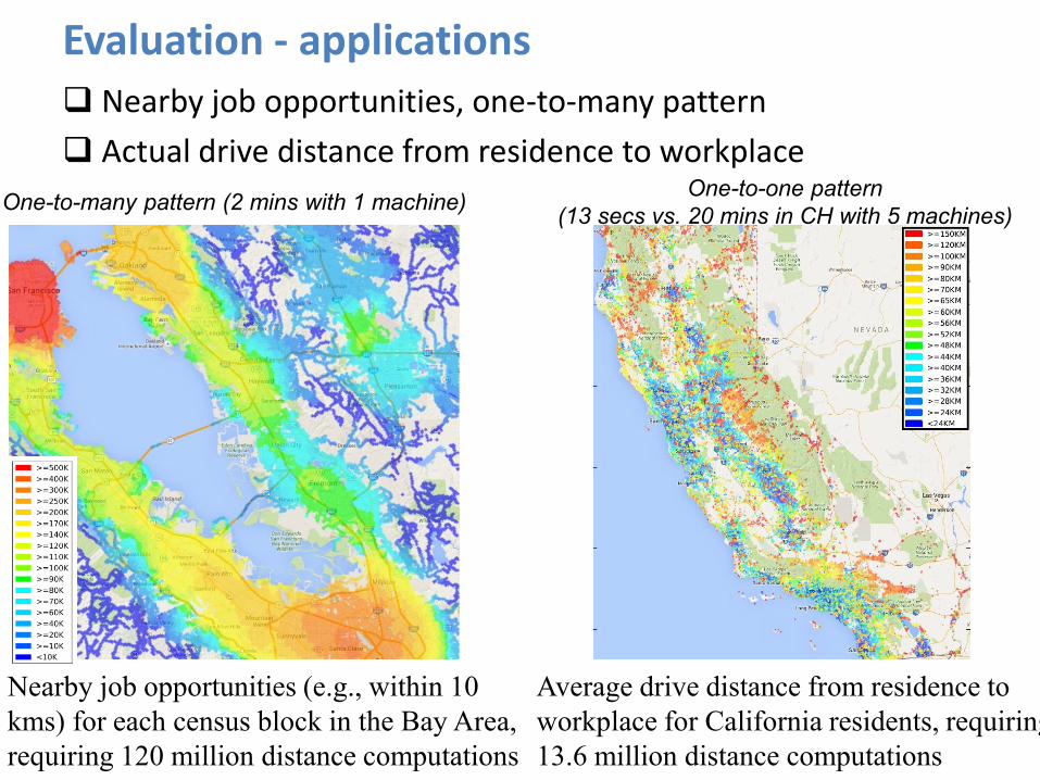
Evaluation - applications Nearby job opportunities, one-to-many pattern
Actual drive distance from residence to workplace
Nearby job opportunities (e.g., within 10
kms) for each census block in the Bay Area,
requiring 120 million distance computations
Average drive distance from residence to
workplace for California residents, requiring
13.6 million distance computations
One-to-many pattern (2 mins with 1 machine) One-to-one pattern
(13 secs vs. 20 mins in CH with 5 machines)

Evaluation - applications Route Directness Index (RDI) of two locations
Ratio of the network distance to the Euclidean distance
Define Route Directness Spectrum (RDS) of a spatial region
The collection of RDIs between all pairs of vertices in a road network
1 mins per city vs. 4 hours in CH with 1 machine
Conclusions SPDO is a high throughput distributed solution for shortest road
network distance/time computations using a distributed key-value store on Apache Spark.
Proposed 3 methods on Apache Spark, Basic, BS, and WP, which are a scalable way of obtaining throughput performance that exceeds one million computations per second with just a few machines
Reduce running time for GIS analysts/scientists, save developing time for GIS developers, and simplify the system design and reduce hardware cost for GIS architects

Thanks