spook, wyoming, disposal site fact sheet - us … · page 1 of 3 a ee e spook, wyoming, disposal...
TRANSCRIPT
Page 1 of 3
Fact Sheet
UMTRCA Title I
Spook, Wyoming, Disposal SiteThis fact sheet provides information about the Uranium Mill Tailings Radiation Control Act of 1978
Title I disposal site located at Spook, Wyoming. The site is managed by the U.S. Department of Energy Office of Legacy Management.
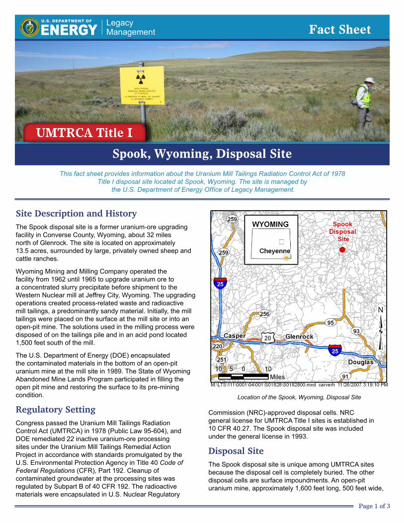
Location of the Spook, Wyoming, Disposal Site
Site Description and History The Spook disposal site is a former uranium-ore upgrading facility in Converse County, Wyoming, about 32 miles north of Glenrock. The site is located on approximately 13.5 acres, surrounded by large, privately owned sheep and cattle ranches.
Wyoming Mining and Milling Company operated the facility from 1962 until 1965 to upgrade uranium ore to a concentrated slurry precipitate before shipment to the Western Nuclear mill at Jeffrey City, Wyoming. The upgrading operations created process-related waste and radioactive mill tailings, a predominantly sandy material. Initially, the mill tailings were placed on the surface at the mill site or into an open-pit mine. The solutions used in the milling process were disposed of on the tailings pile and in an acid pond located 1,500 feet south of the mill.
The U.S. Department of Energy (DOE) encapsulated the contaminated materials in the bottom of an open-pit uranium mine at the mill site in 1989. The State of Wyoming Abandoned Mine Lands Program participated in filling the open pit mine and restoring the surface to its pre-mining condition.
Regulatory SettingCongress passed the Uranium Mill Tailings Radiation Control Act (UMTRCA) in 1978 (Public Law 95-604), and DOE remediated 22 inactive uranium-ore processing sites under the Uranium Mill Tailings Remedial Action Project in accordance with standards promulgated by the U.S. Environmental Protection Agency in Title 40 Code of Federal Regulations (CFR), Part 192. Cleanup of contaminated groundwater at the processing sites was regulated by Subpart B of 40 CFR 192. The radioactive materials were encapsulated in U.S. Nuclear Regulatory
Commission (NRC)-approved disposal cells. NRC general license for UMTRCA Title I sites is established in 10 CFR 40.27. The Spook disposal site was included under the general license in 1993.
Disposal SiteThe Spook disposal site is unique among UMTRCA sites because the disposal cell is completely buried. The other disposal cells are surface impoundments. An open-pit uranium mine, approximately 1,600 feet long, 500 feet wide,

Page 2 of 3
West-East Cross Section of the Spook Disposal Cell
and 100 feet deep, was located adjacent to the former upgrading plant. Contaminated materials, including mill tailings, pond sludge, and building debris, were encapsulated in the south-central part of the mine excavation. The cell contains approximately 315,000 cubic yards of contaminated materials with a total activity of 125 curies of radium-226. Stockpiles of overburden materials around the perimeter of the mine were used to fill the pit after the disposal cell was completed.
Groundwater occurs beneath the site in two sandstone aquifers in the Tertiary-age Wasatch Formation. The upper and lower aquifers are separated by thick silty shale, and the aquifers have no observed hydraulic connection. Water quality in the upper aquifer is affected by naturally occurring mineral deposits that contain uranium and selenium in concentrations exceeding maximum concentration limits in 40 CFR 192. A plume of groundwater in the upper aquifer with milling-related contamination extends approximately 2,500 feet downgradient of the pit. Chromium, nitrate, radium, selenium, and uranium concentrations in the plume exceed background groundwater concentrations. Groundwater in the lower aquifer has not been contaminated.
Because of poor quality and low yield, groundwater from the upper aquifer is not a current or potential source of drinking water in the vicinity of the Spook site. Several wells in the area tap the lower aquifer, which is not affected by the milling operations or natural mineralization.
Compliance StrategyThe groundwater compliance strategy for the upper-most aquifer at the Spook site is no remediation with application of supplemental standards. Supplemental standards may be applied at locations where groundwater is classified as limited use (not a current or potential source of drinking water) because it meets any of several criteria. At the Spook site, groundwater is classified as limited use because of widespread ambient contamination not related to milling
activities that cannot be cleaned up using treatment methods reasonably employed in public water systems (40 CFR 192.11[e][2]). Naturally occurring uranium and selenium in the aquifer exceed maximum concentration limits in 40 CFR 192. Because the upper aquifer is contaminated by naturally occurring minerals, groundwater monitoring is not required.
Disposal Cell DesignThe disposal cell occupies approximately 5 acres of the site. The floor of the open-pit mine was leveled and a 3-foot-thick layer of low-permeability material was placed in the bottom of the pit. The pit was backfilled with contaminated materials to within 45 feet of the surface, and the top was sloped 3 percent. The cover of the polygonal disposal cell is a multi-component system designed to encapsulate and protect the contaminated materials. The disposal cell cover consists of (1) a low-permeability radon barrier (first layer placed over compacted tailings), which consists of clayey soil, and (2) a layer of high-permeability material to minimize infiltration. The surface was graded to blend with the surrounding topography to protect the site from erosion. Disturbed areas have been successfully revegetated with native grasses and shrubs.
Legacy Management ActivitiesThe DOE Office of Legacy Management (LM) manages the disposal site according to a site-specific Long-Term Surveillance Plan. Under provisions of this plan, LM conducts annual inspections of the site to evaluate the condition of surface features and performs site maintenance as necessary.
In accordance with 40 CFR 192.02(a), the disposal cell is designed to be effective for 1,000 years, to the extent reasonably achievable, and, in any case, for at least 200 years. However, the general license has no expiration date, and LM’s responsibility for the safety and integrity of the Spook disposal cell will last indefinitely.

11/2017 Page 3 of 3
A 5.5-acre portion of the site, known as the Former Acid Pond, located approximately 1,500 feet south of the disposal cell was used during plant operations and subsequently remediated during the cleanup and restoration of the Spook site. This parcel was sold to the adjacent landowner in 2015 with deed restrictions limiting surface excavations and water well drilling.
ContactsSite-specific documents related to the Spook disposal site are available on the LM website at https://www.lm.doe.gov/spook/Sites.aspx.
For more information about LM activities at the Spook disposal site, contact:
U.S. Department of Energy Office of Legacy Management 2597 Legacy Way, Grand Junction, CO 81503
(970) 248–6070 (monitored continuously) (877) 695–5322 (toll-free)