sr-35 columbia river crossing study - ts&l -...
TRANSCRIPT
SR-35 Columbia River Crossing Study - TS&LFINAL REPORTOctober 2011


SR-35 COLUMBIA RIVER CROSSING STUDY Final Report i
Table of Contents
Executive Summary . . . . . . . . . . . . . . . . . . . . . . . . . . . . . . . . . . . . . . . . . . . . . . . . . . . . . . . . . . . . . . . . . . . . . . . . . . . . . . . . . . . . . . . . . . . . . . . . . . . . . . . . . . . . . . . . . . . . . . . . 1
1. Introduction . . . . . . . . . . . . . . . . . . . . . . . . . . . . . . . . . . . . . . . . . . . . . . . . . . . . . . . . . . . . . . . . . . . . . . . . . . . . . . . . . . . . . . . . . . . . . . . . . . . . . . . . . . . . . . . . . . . . . . . . . . . . 9
1.1 Study Background . . . . . . . . . . . . . . . . . . . . . . . . . . . . . . . . . . . . . . . . . . . . . . . . . . . . . . . . . . . . . . . . . . . . . . . . . . . . . . . . . . . . . . . . . . . . . . . . . . . . . . . . . . . . . 91.2 Project Purpose and Need . . . . . . . . . . . . . . . . . . . . . . . . . . . . . . . . . . . . . . . . . . . . . . . . . . . . . . . . . . . . . . . . . . . . . . . . . . . . . . . . . . . . . . . . . . . 101.3 Study Process . . . . . . . . . . . . . . . . . . . . . . . . . . . . . . . . . . . . . . . . . . . . . . . . . . . . . . . . . . . . . . . . . . . . . . . . . . . . . . . . . . . . . . . . . . . . . . . . . . . . . . . . . . . . . . . . . . . . . 111.4 Public and Agency Involvement . . . . . . . . . . . . . . . . . . . . . . . . . . . . . . . . . . . . . . . . . . . . . . . . . . . . . . . . . . . . . . . . . . . . . . . . . . . . . . . 12
2. Bridge Type, Size and Location Analysis . . . . . . . . . . . . . . . . . . . . . . . . . . . . . . . . . . . . . . . . . . . . . . . . . . . . . . . . . . . . . . . . . . . 15
2.1 Data Collected . . . . . . . . . . . . . . . . . . . . . . . . . . . . . . . . . . . . . . . . . . . . . . . . . . . . . . . . . . . . . . . . . . . . . . . . . . . . . . . . . . . . . . . . . . . . . . . . . . . . . . . . . . . . . . . . . . 15Ground Survey . . . . . . . . . . . . . . . . . . . . . . . . . . . . . . . . . . . . . . . . . . . . . . . . . . . . . . . . . . . . . . . . . . . . . . . . . . . . . . . . . . . . . . . . . . . . . . . . . . . . . . . . . . . . . . . 15Subsurface Exploration and Testing . . . . . . . . . . . . . . . . . . . . . . . . . . . . . . . . . . . . . . . . . . . . . . . . . . . . . . . . . . . . . . . . . . . . . . . . . 16Geophysical Survey . . . . . . . . . . . . . . . . . . . . . . . . . . . . . . . . . . . . . . . . . . . . . . . . . . . . . . . . . . . . . . . . . . . . . . . . . . . . . . . . . . . . . . . . . . . . . . . . . . . . . . . 17Bathymetric Survey . . . . . . . . . . . . . . . . . . . . . . . . . . . . . . . . . . . . . . . . . . . . . . . . . . . . . . . . . . . . . . . . . . . . . . . . . . . . . . . . . . . . . . . . . . . . . . . . . . . . . . . 17
2.2 Design Criteria . . . . . . . . . . . . . . . . . . . . . . . . . . . . . . . . . . . . . . . . . . . . . . . . . . . . . . . . . . . . . . . . . . . . . . . . . . . . . . . . . . . . . . . . . . . . . . . . . . . . . . . . . . . . . . . . . 182.3 Navigation Survey Validation . . . . . . . . . . . . . . . . . . . . . . . . . . . . . . . . . . . . . . . . . . . . . . . . . . . . . . . . . . . . . . . . . . . . . . . . . . . . . . . . . . . . . 192.4 Environmental . . . . . . . . . . . . . . . . . . . . . . . . . . . . . . . . . . . . . . . . . . . . . . . . . . . . . . . . . . . . . . . . . . . . . . . . . . . . . . . . . . . . . . . . . . . . . . . . . . . . . . . . . . . . . . . . . . 19
Built Environment Considerations . . . . . . . . . . . . . . . . . . . . . . . . . . . . . . . . . . . . . . . . . . . . . . . . . . . . . . . . . . . . . . . . . . . . . . . . . . . 19Natural Environment Considerations . . . . . . . . . . . . . . . . . . . . . . . . . . . . . . . . . . . . . . . . . . . . . . . . . . . . . . . . . . . . . . . . . . . . . . 20
2.5 Bridge Aesthetics . . . . . . . . . . . . . . . . . . . . . . . . . . . . . . . . . . . . . . . . . . . . . . . . . . . . . . . . . . . . . . . . . . . . . . . . . . . . . . . . . . . . . . . . . . . . . . . . . . . . . . . . . . . . . . 21Design Workshop . . . . . . . . . . . . . . . . . . . . . . . . . . . . . . . . . . . . . . . . . . . . . . . . . . . . . . . . . . . . . . . . . . . . . . . . . . . . . . . . . . . . . . . . . . . . . . . . . . . . . . . . . . . 21
2.6 Recommended Preferred Bridge Alternative . . . . . . . . . . . . . . . . . . . . . . . . . . . . . . . . . . . . . . . . . . . . . . . . . . . . . . 22Criteria and Weighting . . . . . . . . . . . . . . . . . . . . . . . . . . . . . . . . . . . . . . . . . . . . . . . . . . . . . . . . . . . . . . . . . . . . . . . . . . . . . . . . . . . . . . . . . . . . . . . . . 22
Option 1 – Steel Plate Girder . . . . . . . . . . . . . . . . . . . . . . . . . . . . . . . . . . . . . . . . . . . . . . . . . . . . . . . . . . . . . . . . . . . . . . . . . . . . 22Option 2 – Concrete Segmental Box Girder . . . . . . . . . . . . . . . . . . . . . . . . . . . . . . . . . . . . . . . . . . . . . . . . . 24Option 3 – Steel Tied Arch . . . . . . . . . . . . . . . . . . . . . . . . . . . . . . . . . . . . . . . . . . . . . . . . . . . . . . . . . . . . . . . . . . . . . . . . . . . . . . . . 24
Recommendation . . . . . . . . . . . . . . . . . . . . . . . . . . . . . . . . . . . . . . . . . . . . . . . . . . . . . . . . . . . . . . . . . . . . . . . . . . . . . . . . . . . . . . . . . . . . . . . . . . . . . . . . . . 28Design Refinement . . . . . . . . . . . . . . . . . . . . . . . . . . . . . . . . . . . . . . . . . . . . . . . . . . . . . . . . . . . . . . . . . . . . . . . . . . . . . . . . . . . . . . . . . . . . . . . . . . . . . . . . 31
Storm Water . . . . . . . . . . . . . . . . . . . . . . . . . . . . . . . . . . . . . . . . . . . . . . . . . . . . . . . . . . . . . . . . . . . . . . . . . . . . . . . . . . . . . . . . . . . . . . . . . . . . . . . . . . 31Hydraulic Modeling and Scour Analysis . . . . . . . . . . . . . . . . . . . . . . . . . . . . . . . . . . . . . . . . . . . . . . . . . . . . . . . . 31Right-of-Way . . . . . . . . . . . . . . . . . . . . . . . . . . . . . . . . . . . . . . . . . . . . . . . . . . . . . . . . . . . . . . . . . . . . . . . . . . . . . . . . . . . . . . . . . . . . . . . . . . . . . . . . . 31Construction . . . . . . . . . . . . . . . . . . . . . . . . . . . . . . . . . . . . . . . . . . . . . . . . . . . . . . . . . . . . . . . . . . . . . . . . . . . . . . . . . . . . . . . . . . . . . . . . . . . . . . . . 32
Artist Rendering . . . . . . . . . . . . . . . . . . . . . . . . . . . . . . . . . . . . . . . . . . . . . . . . . . . . . . . . . . . . . . . . . . . . . . . . . . . . . . . . . . . . . . . . . . . . . . . . . . . . . . . . . . . . . 32
3. Project Cost Estimate . . . . . . . . . . . . . . . . . . . . . . . . . . . . . . . . . . . . . . . . . . . . . . . . . . . . . . . . . . . . . . . . . . . . . . . . . . . . . . . . . . . . . . . . . . . . . . . . . . . . . . . 36
4. Economic Analysis . . . . . . . . . . . . . . . . . . . . . . . . . . . . . . . . . . . . . . . . . . . . . . . . . . . . . . . . . . . . . . . . . . . . . . . . . . . . . . . . . . . . . . . . . . . . . . . . . . . . . . . . . . . . . 38
5. Updated Final EIS Scope of Services . . . . . . . . . . . . . . . . . . . . . . . . . . . . . . . . . . . . . . . . . . . . . . . . . . . . . . . . . . . . . . . . . . . . . . . . . . 42
Table of Contents
Prepared By
400 SW Sixth Avenue, Suite 802 Portland, Oregon 97204 Telephone: (503) 274-7225
Primary Authors
Mark Hirota, P.E., Project Manager Laura Amundson, P.E., Bridge Task Lead
Additional Information
For more information about the SR-35 Columbia River Crossing Study, contact: Dale Robins Regional Transportation Council Telephone: (360) 397-6067, x5212 E-mail: [email protected] Project Website: http://www.rtc.wa.gov/studies/sr35
The following appendices are available as a separate document:
Appendix A Final Geotechnical Data Report
Appendix B Project Design Criteria
Appendix C Navigation Survey Validation memorandum
Appendix D Gorge Management Plan Amendment
Appendix E Foundations Recommendations memorandum
Appendix F Bridge TS&L Drawings
Appendix G Preliminary Storm Water Analysis memorandum
Appendix H HECRAS Scour memorandum
Appendix I Preliminary Cost Estimate Data
Appendix J Navigation Survey Validation memorandum
Appendix K Final EIS Scope of Services
285 Liberty Street NE, Suite 350 Salem, OR 97301
17355 SW Boones Ferry Road Lake Oswego, OR 97035
Northwest Hydro Inc.31 Cougar Creek Road Skamania, WA 98648
1419 Washington Street, Suite 101 Oregon City, Oregon 97045
ECONORTHWEST99 West 10th Avenue, Suite 400 Eugene, Oregon 97401
434 NW 6th Avenue, Suite 304 Portland, OR 97209-3652
SR-35 COLUMBIA RIVER CROSSING STUDY Final Report 1
EXECUTIVE SUMMARY
Executive Summary
Study Background
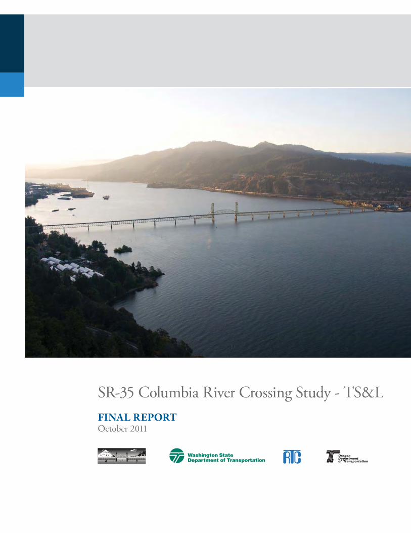
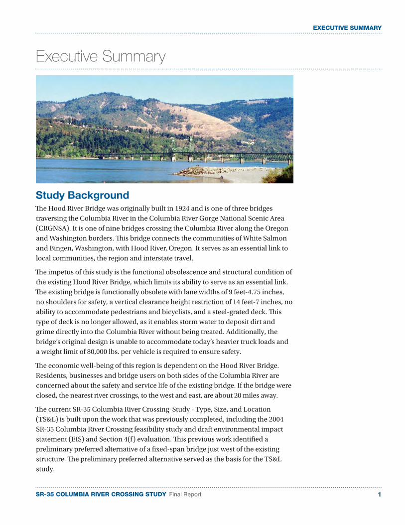
The Hood River Bridge was originally built in 1924 and is one of three bridges traversing the Columbia River in the Columbia River Gorge National Scenic Area (CRGNSA). It is one of nine bridges crossing the Columbia River along the Oregon and Washington borders. This bridge connects the communities of White Salmon and Bingen, Washington, with Hood River, Oregon. It serves as an essential link to local communities, the region and interstate travel.
The impetus of this study is the functional obsolescence and structural condition of the existing Hood River Bridge, which limits its ability to serve as an essential link. The existing bridge is functionally obsolete with lane widths of 9 feet-4.75 inches, no shoulders for safety, a vertical clearance height restriction of 14 feet-7 inches, no ability to accommodate pedestrians and bicyclists, and a steel-grated deck. This type of deck is no longer allowed, as it enables storm water to deposit dirt and grime directly into the Columbia River without being treated. Additionally, the bridge’s original design is unable to accommodate today’s heavier truck loads and a weight limit of 80,000 lbs. per vehicle is required to ensure safety.
The economic well-being of this region is dependent on the Hood River Bridge. Residents, businesses and bridge users on both sides of the Columbia River are concerned about the safety and service life of the existing bridge. If the bridge were closed, the nearest river crossings, to the west and east, are about 20 miles away.
The current SR-35 Columbia River Crossing Study - Type, Size, and Location (TS&L) is built upon the work that was previously completed, including the 2004 SR-35 Columbia River Crossing feasibility study and draft environmental impact statement (EIS) and Section 4(f) evaluation. This previous work identified a preliminary preferred alternative of a fixed-span bridge just west of the existing structure. The preliminary preferred alternative served as the basis for the TS&L study.

SR-35 COLUMBIA RIVER CROSSING STUDY Final Report2
EXECUTIVE SUMMARY
Project Purpose and Need
The overall purpose of the SR-35 Columbia River Crossing project is to improve the movement of people and goods across the Columbia River between the White Salmon/Bingen and Hood River communities with the identified need of improving current and future transportation inadequacies and deficiencies associated with the existing Hood River Bridge. Specifically, these needs are to:
■ Alleviate current and future congestion
■ Provide cross-river linkage
■ Accommodate cross-river travel demand, including bicycle and pedestrian travel
■ Satisfy cross-river flow of goods and people
■ Accommodate river navigation
■ Improve safety
Study Process
In 2010, the TS&L phase of the SR-35 Columbia River Crossing project was initiated and included the following elements:
■ An economic analysis of the existing bridge and the benefits of a new bridge
■ Advancement of the preliminary engineering and the determination of a recommended preferred bridge type
■ Estimated cost of the preferred bridge alternative
■ Scope of services for the next phase of the project: the final environmental impact statement (FEIS).
Public and Agency Involvement
The SR-35 Columbia River Crossing Study – TS&L used an extensive public and agency involvement process and included several committees and public involvement opportunities.
Bi-State Committee: Comprised of elected officials and agency staff from both Washington and Oregon to guide the overall process.
Focus Groups: Comprised of broad range of interest, from commuters to business and freight operators to recreational and environmental interest. The focus groups were used to gather some of the necessary information for the economic analysis.
Design Workshop: Early in the project, Bi-State Committee members and key stakeholders were brought together to help inform the project team of key project issues and obtain input on design elements.
Columbia River Gorge Commission: Project team met with a staff member of the Columbia River Gorge Commission to gain further understanding of the Columbia River bridge replacement guidelines, found in the Gorge Management Plan.

SR-35 COLUMBIA RIVER CROSSING STUDY Final Report 3
EXECUTIVE SUMMARY
Barge and Tow Operators: As the pier shapes and sizes were being developed input from the Tug Boat Association was sought.
Other Involvement: In addition to these meetings, information was provided to the general public through a project website, press releases, newspaper articles, study report folio and a public open house.
Bridge Type, Size and Location (TS&L) Analysis
The bridge TS&L analysis included collecting data, developing design criteria, validating the previous River Navigation Survey, ensuring environmental considerations were met, and evaluating the bridge alternatives and recommending the preferred alternative.
Data Collection: In support of the preliminary engineering effort needed to evaluate the three bridge alternatives, data was collected to provide an accurate understanding of the existing conditions at the proposed bridge site. The data collected included ground survey, subsurface exploration and testing, and geophysical and bathymetric surveys.
■ Ground survey was performed to help establish were the existing features are and the most efficient location for the new bridge.
■ Subsurface exploration and testing were performed at three locations along the proposed bridge alignment. The three locations yielded a clear understanding of the elevations of rock. This valuable information helped establish properly sized bridge foundations.
■ Geophysical survey was performed in the vicinity of the proposed bridge alignment. This information helps provide an understanding of the elevation of the rock line, where soil explorations were not performed.
■ Bathymetric survey establishes the depth of the water or river bottom elevations. This information is used in the flood plain analysis.
Design Criteria: The bridge analysis spans two states and several local jurisdictions. For this analysis, it was not imperative that a comprehensive list of all project design criteria be established by the two state departments of transportation. However, certain design criteria did surface as fundamental or foundational criteria to determining the type, size, and therefore construction cost of the bridge. Agreement was required and achieved by both agencies on these criteria.
Design criteria that affected the footprint of the bridge included the functional classification of the roadway, the number of travel lanes, the width of the shoulders, the number of pedestrian walkways on the bridge and their widths. Additionally, the required navigation clearance of 450 feet high by 80 feet wide was considered foundational criteria.
Environmental: Both the built environment and natural environment needed to be considered. The project lies at a crossroads of transportation modes in the region. The bridge provides connection to I-84 to the south and SR-14 to the north. The
SR-35 COLUMBIA RIVER CROSSING STUDY Final Report4
EXECUTIVE SUMMARY
bridge spans the Columbia River and must accommodate river navigation. On the Washington side, the bridge spans the BNSF mainline track.
The natural environment in the project vicinity is dominated by the Columbia River and scenic beauty that it provides. With the project residing within the national scenic area, portions of this project fall under the guidance of the Management Plan for the Columbia River Gorge.
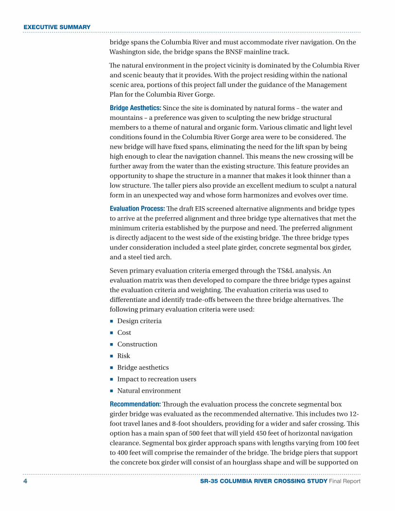
Bridge Aesthetics: Since the site is dominated by natural forms – the water and mountains – a preference was given to sculpting the new bridge structural members to a theme of natural and organic form. Various climatic and light level conditions found in the Columbia River Gorge area were to be considered. The new bridge will have fixed spans, eliminating the need for the lift span by being high enough to clear the navigation channel. This means the new crossing will be further away from the water than the existing structure. This feature provides an opportunity to shape the structure in a manner that makes it look thinner than a low structure. The taller piers also provide an excellent medium to sculpt a natural form in an unexpected way and whose form harmonizes and evolves over time.
Evaluation Process: The draft EIS screened alternative alignments and bridge types to arrive at the preferred alignment and three bridge type alternatives that met the minimum criteria established by the purpose and need. The preferred alignment is directly adjacent to the west side of the existing bridge. The three bridge types under consideration included a steel plate girder, concrete segmental box girder, and a steel tied arch.
Seven primary evaluation criteria emerged through the TS&L analysis. An evaluation matrix was then developed to compare the three bridge types against the evaluation criteria and weighting. The evaluation criteria was used to differentiate and identify trade-offs between the three bridge alternatives. The following primary evaluation criteria were used:
■ Design criteria
■ Cost
■ Construction
■ Risk
■ Bridge aesthetics
■ Impact to recreation users
■ Natural environment
Recommendation: Through the evaluation process the concrete segmental box girder bridge was evaluated as the recommended alternative. This includes two 12-foot travel lanes and 8-foot shoulders, providing for a wider and safer crossing. This option has a main span of 500 feet that will yield 450 feet of horizontal navigation clearance. Segmental box girder approach spans with lengths varying from 100 feet to 400 feet will comprise the remainder of the bridge. The bridge piers that support the concrete box girder will consist of an hourglass shape and will be supported on

SR-35 COLUMBIA RIVER CROSSING STUDY Final Report 5
EXECUTIVE SUMMARY
footings that are placed one foot above the two-year recurrence interval elevation of the Columbia River. Two pedestrian overlooks will be placed on the downstream side of the bridge at each of the main span piers. Gateway markers and aesthetic treatments will be placed at each of the entry points of the bridge and will provide a coordinated treatment with the stone formwork used on the pedestrian side of the roadway barrier.
Design Refinement: With the evaluation of the three bridge alternatives concluding with the segmental concrete box girder bridge as the recommended preferred bridge alternative, analysis was continued and refined on the preferred alternative in several areas, such as storm water, bridge hydraulics, right-of-way and construction.
■ Storm water: With direct discharge into the river no longer acceptable, a preliminary review of storm water collection and treatment was performed to determine feasible options and check for potential obstacles to completion of the storm water design for the bridge. This preliminary analysis concluded that the anticipated storm water volume can be collected in the roadway gutters and down to the Washington and Oregon bridge abutments. The flow would travel through catch basins and on to storm water treatment vaults. Bioswales were considered as an option to vaults, but required a larger physical area than the vaults.
■ Hydraulic modeling and scour analysis: Since the proposal is to replace an existing bridge with a new bridge, a calculation of the backwater created by the new bridge was compared to the backwater created by the recommended preferred bridge alternative. For a 100-year flood event, calculations indicated that the bridge piers of the recommended preferred bridge alternative raise the water surface approximately ⅛ inch, which is well within acceptable limits.
■ Right-of-way: It is understood that the north approach to the bridge is on private property. It was indicated at the Bi-State Committee meeting that the property was in condemnation and that it would likely revert to either the City of White Salmon or Klickitat County in the future. The south bridge approach is located on property owned by the Port of Hood River.
■ Construction: For this bridge analysis, it has been assumed that the superstructure will use cast-in-place segmental construction. This is due primarily to the large weight and size of the segments. The bridge will be constructed adjacent to the existing bridge, which will continue to carry the traffic during construction. There will be short periods of time where traffic staging will be performed to make the approach connections to the bridge, but it is expected that construction activities will not generally affect the traffic conditions in Hood River or White Salmon. It is expected that the bridge construction will take two to three years. Once the foundations and piers are constructed, a contractor may choose to construct the superstructure at multiple locations to decrease the construction duration.
SR-35 COLUMBIA RIVER CROSSING STUDY Final Report6
EXECUTIVE SUMMARY
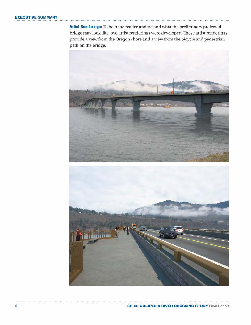
Artist Renderings: To help the reader understand what the preliminary preferred bridge may look like, two artist renderings were developed. These artist renderings provide a view from the Oregon shore and a view from the bicycle and pedestrian path on the bridge.
SR-35 COLUMBIA RIVER CROSSING STUDY Final Report 7
EXECUTIVE SUMMARY
Project Cost Estimate
With the determination of the concrete segmental box girder as the recommended alternative, the construction cost estimate range and overall project cost estimate range was prepared.
The construction cost estimate was developed by calculating the quantities from the type, size, and location drawings and then using a combination of historical unit prices and unit price analysis to develop the estimated construction cost.
In present day (2011) dollars, the project’s overall cost estimate range is $190 million to $205 million. Besides the bridge construction cost, this range includes other items such as the cost for the roadway approaches, existing bridge removal, storm water collection and treatment, right of way, engineering, sales tax, and a contingency allowance. If the bridge construction were to start in year 2020, with an assumed inflation rate of four percent, the project’s overall cost estimate range would be $270 million to $290 million.
Economic Analysis
The economic analysis confirmed that the bridge plays a significant role in both the regional transportation network and the regional economy. Businesses depend on access to workers on both sides of the bridge. Commuting to work accounts for about 10–15 percent of daily bridge trips. Hood River is the economic center of the region. Residents of Washington depend on the bridge to shop and conduct business in Hood River. Businesses in Hood River depend on Washington residents as customers.
Most freight goods that cross the bridge are wood products and fruit for processing, use within the region, or for export outside of the region. The weight-restricted bridge limits manufacturing and processing choices for businesses.
Visitors to the region use the bridge to access attractions or recreational opportunities on both sides of the river, as well as the retail and accommodations services available primarily in Hood River.
The bridge also allows local emergency-service providers with the opportunity to combine resources and support each other.
Disruption to bridge service would have a detrimental impact on the regional economy.

SR-35 COLUMBIA RIVER CROSSING STUDY Final Report8
EXECUTIVE SUMMARY
This page left intentionally blank.
SR-35 COLUMBIA RIVER CROSSING STUDY Final Report 9
SECTION 1 Introduction
SECTION 1
Introduction
1.1 Study Background
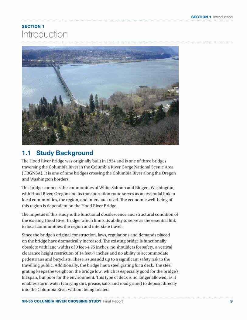
The Hood River Bridge was originally built in 1924 and is one of three bridges traversing the Columbia River in the Columbia River Gorge National Scenic Area (CRGNSA). It is one of nine bridges crossing the Columbia River along the Oregon and Washington borders.
This bridge connects the communities of White Salmon and Bingen, Washington, with Hood River, Oregon and its transportation route serves as an essential link to local communities, the region, and interstate travel. The economic well-being of this region is dependent on the Hood River Bridge.
The impetus of this study is the functional obsolescence and structural condition of the existing Hood River Bridge, which limits its ability to serve as the essential link to local communities, the region and interstate travel.
Since the bridge’s original construction, laws, regulations and demands placed on the bridge have dramatically increased. The existing bridge is functionally obsolete with lane widths of 9 feet-4.75 inches, no shoulders for safety, a vertical clearance height restriction of 14 feet-7 inches and no ability to accommodate pedestrians and bicyclists. These issues add up to a significant safety risk to the travelling public. Additionally, the bridge has a steel grating for a deck. The steel grating keeps the weight on the bridge low, which is especially good for the bridge’s lift span, but poor for the environment. This type of deck is no longer allowed, as it enables storm water (carrying dirt, grease, salts and road grime) to deposit directly into the Columbia River without being treated.

SR-35 COLUMBIA RIVER CROSSING STUDY Final Report10
SECTION 1 Introduction
Over the years, in an attempt to combat increasing fuel costs, truck gross vehicle weights have increased. The heavier trucks have placed more demand on the bridge’s structural capacity. So much so that the bridge’s original design is unable to accommodate today’s heavier truck loads. A weight limit of 80,000 lbs. (gross vehicle weight) is required to ensure the safety of the travelling public.
The current SR-35 Columbia River Crossing Study - TS&L is built upon the work that was previously completed, including the 2004 SR-35 Columbia River Crossing feasibility study and draft environmental impact statement (EIS) and Section 4(f) evaluation. This previous work identified a preliminary preferred alternative that includes a fix-span bridge just west of the existing structure. This alternative would connect the south end of the existing bridge Interstate 84 access road. On the north end, it would intersect with SR-14 immediately west of the existing intersection. The preliminary preferred alternative served as the basis for the TS&L study.
1.2 Project Purpose and Need
The overall purpose of the SR-35 Columbia River Crossing project is to improve the movement of people and goods across the Columbia River between the White Salmon/Bingen and Hood River communities with the identified need of improving current and future transportation inadequacies and deficiencies associated with the existing Hood River Bridge. Specifically, these needs are to:
■ Alleviate current and future congestion at the bridge termini, on the bridge itself and the access road to and from the bridge (SR-35), and congestion related to diverted traffic due to severe weather conditions or incidents on Mount Hood, Interstate 84, or SR-14
■ Provide cross-river linkage to the Oregon and Washington state transportation systems
■ Accommodate the increase in cross-river demand while also providing for bicycle and pedestrian travel across the Columbia River
■ Satisfy social demands and economic needs for cross-river flow of goods and people
■ Accommodate river navigation by providing horizontal and vertical clearances which meet current standards while also providing intermodal and multimodal connections across the river
■ Address and improve upon safety and the substandard design of the current bridge
SR-35 COLUMBIA RIVER CROSSING STUDY Final Report 11
SECTION 1 Introduction
1.3 Study Process
In 2010, the TS&L phase of the SR-35 Columbia River Crossing project was initiated. This effort continued the involvement of the public and key stakeholders and advanced the following project elements:
■ An economics analysis to evaluate the dependence of the region on the Columbia River Bridge and the economic benefits of a new bridge,
■ A bridge TS&L analysis to further the preliminary engineering of the project, determine a recommended preferred bridge alternative and provide information to support the final EIS,
■ An updated cost estimate for the recommended preferred bridge alternative, and
■ A scope of services that will help guide the next phase of the project: the final environmental impact statement (FEIS).
■ A Project Management Team (PMT) was formed and met regularly through the study process. The PMT consisted of staff from RTC, WSDOT and ODOT and was established to review the project team’s technical work and provide direction.
The overall process included the following steps:
■ Data Review and Update: with the previous work being completed 6-7 years earlier, the reports and studies were reviewed and determinations made on what information needed to be validated. For example, the Navigation Survey evaluated the navigation clearance needed by various river users and recommended a vertical and horizontal navigation clearance for the bridge’s fixed main span. The data that formed the basis for this recommendation was re-evaluated and confirmed to still be valid.
■ Economic Analysis: For the economic analysis, key areas of investigation included; Impact of short term and permanent closure of the existing bridge and the long term economic implications of retaining the existing bridge. Investigation and research was performed on various existing studies and reports. Additionally, focus group meetings with businesses, industries, and residents were conducted to gather input.
■ Bridge TS&L Analysis: The preliminary engineering was advanced on the three bridge alternatives to the extent that an evaluation the three alternatives could be performed and select a recommended preferred alternative. Base engineering data such as ground, bathymetric and geophysical survey data was collected. Additionally, soil exploration and laboratory testing was performed on the samples to determine soil and rock elevations and strength properties.
From this information, preliminary span lengths, pier locations, pier sizes and column shapes were developed. Bridge drawings were produced to document the preliminary bridge design.
To illustrate the recommended preferred bridge alternative, artist renderings were developed of two views; from the shore and from the pedestrian path.
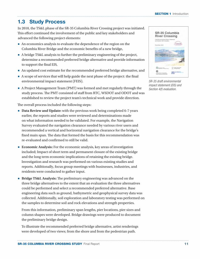
SR-35 draft environmental impact statement (EIS) and Section 4(f) evaluation.
SR-35 COLUMBIA RIVER CROSSING STUDY Final Report12
SECTION 1 Introduction
■ Final EIS Scope of Services: A draft final EIS scope of services was developed during the completion of the draft EIS project. This work was updated through a review of what has been done since the completion of the draft EIS.
■ Cost Estimate: A rough quantity based cost estimate for the recommended preferred bridge alternative (in year 2011 dollars) was provided. For this effort, preliminary bridge design was performed to an extent in order to determine reasonable sizes of the bridge elements. Where available, quantities were calculated. Other major quantities were estimated from typical estimating guidelines. Unit prices for quantities were estimated from cost history data from recent bid items in Oregon and Washington.
The study process included extensive public and agency outreach, which is described in the next section.
1.4 Public and Agency Involvement
The SR-35 Columbia River Crossing Study –TS&L used an extensive public and agency involvement process and included several committees and public involvement opportunities.
A Bi-State Committee of elected officials and agency staff was established to guide the overall process. The Bi-State Committee consisted of:
■ Arthur Babitz (City of Hood River)
■ Betty Barnes (City of Bingen)
■ John Davies (Port of Hood River)
■ Bart Gernhart (WSDOT)
■ Rex Johnston (Klickitat County)
■ Rich McBride (Port of Hood River)
■ Maui Meyer (Hood River County)
■ Paul Pearce (Skamania County)
■ David Poucher (City of White Salmon)
■ Bill Schmitt (Port of Klickitat)
■ Rich Watanabe (ODOT)
This group provided key stakeholder perspectives and direction to the study team. They met three times – at the inception of the project, for validation of the recommended preferred bridge alternative and at the conclusion of the study.
Focus Groups: For the economic analysis, focus groups were used to gather some of the necessary information and also provided public outreach. Four focus groups met for 90 minutes each. Participants represented a broad range of interests, from commuters to business and freight operators to recreational and environmental interests. The four groups were:
1. Public agencies and transportation providers;
2. Business, retail and commute interests;
3. Private companies and freight-dependent businesses; and
4. Recreational economy interests.
The meetings were facilitated to ensure that each participant had an opportunity to talk and that all the topics of discussion were covered to some degree in each group.
“The bridge should age gracefully and become like an old friend of ours. Over time, it should be become ‘comfortable,’ like a good pair of shoes.” – Bi-State Committee
SR-35 COLUMBIA RIVER CROSSING STUDY Final Report 13
SECTION 1 Introduction
Columbia River Gorge Commission: In November 2010, the project team met with a staff member of the Columbia River Gorge Commission to get the commission’s perspective on the intent behind the amendment to the Gorge Management Plan that addressed the replacement of the bridge. This information was used in developing bridge aesthetic concepts that were discussed at the Design Workshop.
Design Workshop: Early in the project, the Bi-State Committee and other key stakeholders were brought together to participate in a design work shop that helped inform the project team of key project issues. Key stakeholders invited included:
■ Confederate Tribes of Warm Springs
■ Confederate Tribes of the Umatilla
■ Nez Perce Tribe
■ Yakima Nation
■ Columbia River Gorge Commission
■ Mid Columbia Council of Governments
■ Hood River Chamber of Commerce/Downtown Business Council
■ Mount Adams Chamber of Commerce
■ Mid Columbia Economic Development District
■ Friends of the Gorge
■ Columbia Gorge Windsurfing Association and the Columbia Gorge Recreation Coalition
■ Barge/tow operators
■ USDA Forest Service Columbia Gorge National Scenic Area
Input from this workshop, through the workshop discussions and activities or comments emailed to the project team later, were used to further develop the bridge alternatives and serve as criteria to evaluate them to determine the recommended preferred bridge alternative.
Barge/Tow Operators: As the pier shapes and sizes were being developed; Jerry Grossnickle was contacted for input. Jerry vetted pier design concepts through the Tug Boat Association and indicated no objection to the design concepts.
Study Report Folio: A folio was developed for public distribution, which summarized the findings of the study.
Open House: On October 12, 2011, the project concluded with an open house to share the results with the public and key stakeholders.
Media: News releases were distributed to local media, announcing the design workshop, focus group meetings and the open house.
Project Website: Throughout the study, RTC has provided project information on its website: http://www.rtc.wa.gov/studies/sr35.
SR-35 COLUMBIA RIVER CROSSING STUDY Final Report14
SECTION 1 Introduction
This page left intentionally blank.

SR-35 COLUMBIA RIVER CROSSING STUDY Final Report 15
SECTION 2 Bridge Type, Size and Location Analysis
SECTION 2
Bridge Type, Size and Location Analysis
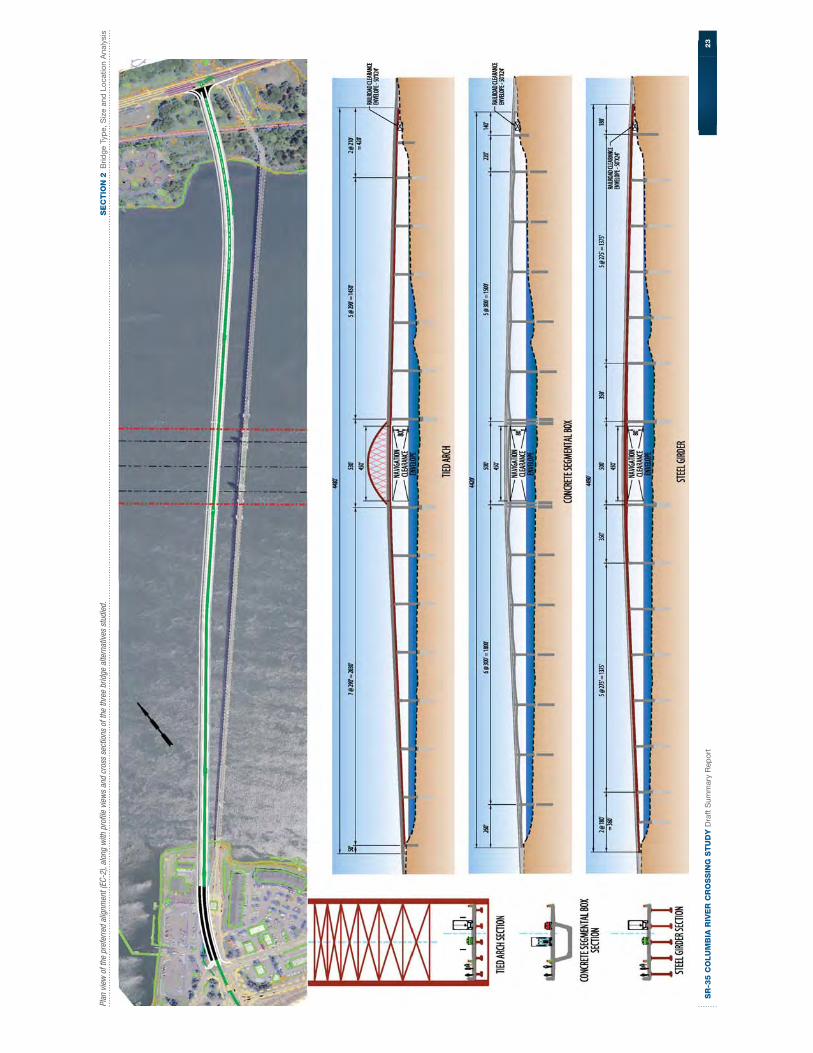
During the draft EIS, various river crossing alignments and bridge types were investigated, discussed and debated. One river crossing alignment (EC-2) emerged as the preferred alignment alternative. This alignment is directly adjacent to the west side of the existing bridge until a point north of the shipping channel, where it shifts slightly to the east to avoid the in-lieu fishing site on the Washington side. It would be grade separated from the railroad mainline on the Washington side. The SR-14 intersection would be signalized and widened to accommodate turn lanes.
Additionally, three bridge type alternatives (tied arch bridge, segmental concrete box girder bridge and girder bridge) emerged as viable alternatives,
This next phase in the project process, the bridge TS&L analysis, continued from where the draft EIS concluded and further advanced the bridge engineering for the bridge type alternatives on the preferred alignment alternative.
The bridge analysis included collecting data, developing design criteria, validating the previous River Navigation Survey, ensuring environmental considerations were met, and evaluating the bridge alternatives and recommending the preferred alternative.
2.1 Data Collected
In support of the preliminary engineering effort needed to evaluate the three bridge alternatives, data was collected to provide an accurate understanding of the existing conditions at the proposed bridge site. The data collected included ground survey, subsurface exploration and testing, and geophysical and bathymetric surveys.
Ground Survey
Ground survey (topographic survey) was performed in the immediate project area to help establish where the existing features (shoreline, buildings, existing bridge, rail road) are and the most efficient location for the new bridge.
The most effective method of performing the ground survey was through aerial photography and photogrammetric methods. Ground survey was taken to validate the aerial survey work.
Preferred bridge alignment (EC-2), directly west of the existing bridge.
SR-35 COLUMBIA RIVER CROSSING STUDY Final Report16
SECTION 2 Bridge Type, Size and Location Analysis
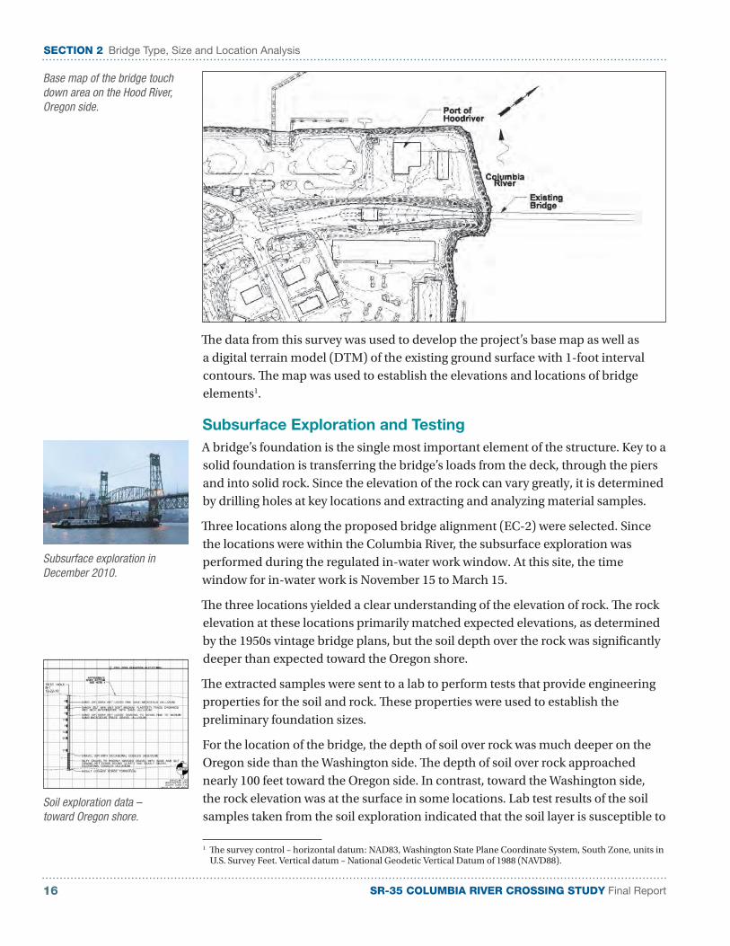
The data from this survey was used to develop the project’s base map as well as a digital terrain model (DTM) of the existing ground surface with 1-foot interval contours. The map was used to establish the elevations and locations of bridge elements1.
Subsurface Exploration and Testing
A bridge’s foundation is the single most important element of the structure. Key to a solid foundation is transferring the bridge’s loads from the deck, through the piers and into solid rock. Since the elevation of the rock can vary greatly, it is determined by drilling holes at key locations and extracting and analyzing material samples.
Three locations along the proposed bridge alignment (EC-2) were selected. Since the locations were within the Columbia River, the subsurface exploration was performed during the regulated in-water work window. At this site, the time window for in-water work is November 15 to March 15.
The three locations yielded a clear understanding of the elevation of rock. The rock elevation at these locations primarily matched expected elevations, as determined by the 1950s vintage bridge plans, but the soil depth over the rock was significantly deeper than expected toward the Oregon shore.
The extracted samples were sent to a lab to perform tests that provide engineering properties for the soil and rock. These properties were used to establish the preliminary foundation sizes.
For the location of the bridge, the depth of soil over rock was much deeper on the Oregon side than the Washington side. The depth of soil over rock approached nearly 100 feet toward the Oregon side. In contrast, toward the Washington side, the rock elevation was at the surface in some locations. Lab test results of the soil samples taken from the soil exploration indicated that the soil layer is susceptible to
1 The survey control – horizontal datum: NAD83, Washington State Plane Coordinate System, South Zone, units in U.S. Survey Feet. Vertical datum – National Geodetic Vertical Datum of 1988 (NAVD88).
Subsurface exploration in December 2010.
Soil exploration data – toward Oregon shore.
Base map of the bridge touch down area on the Hood River, Oregon side.

SR-35 COLUMBIA RIVER CROSSING STUDY Final Report 17
SECTION 2 Bridge Type, Size and Location Analysis
liquefaction in a seismic event. This valuable information helped establish properly sized bridge foundations that will withstand soil liquefaction in a seismic event.
The final geotechnical data report provides detailed information on the soil exploration and testing and can be found in Appendix A.
Geophysical Survey
A geophysical survey was performed in the vicinity of the proposed bridge alignment. Much like the soil exploration, a geophysical survey provides an understanding of the elevation of the rock line. The results are not as accurate as the actual soil exploration, but the procedure is a cost-effective method to estimate the rock elevation at locations where soil exploration was not performed.
The survey closely matched the rock elevation, determined by the exploration, and provided the project team with a high level of confidence on where the rock elevation is along the entire length of the proposed bridge alignment.
Bathymetric Survey
A bathymetric survey establishes the depth of the water. Knowing the water surface elevation, the river bottom elevation can then be established. This information is used in the flood plain analysis, which determines how much (if any) the proposed bridge would back up the flow from the Columbia River.
Seven transects for the bathymetric survey.
SR-35 COLUMBIA RIVER CROSSING STUDY Final Report18
SECTION 2 Bridge Type, Size and Location Analysis
Data was collected on seven transects (lines) in the vicinity of the bridge. The seven transects were at the following locations:
■ Approximately one mile downstream from the proposed bridge
■ Approximately 0.5 mile downstream from the proposed bridge
■ At the proposed bridge (approximately 300 feet downstream from the existing bridge)
■ Downstream face of existing bridge
■ Upstream face of existing bridge
■ Approximately 0.5 mile upstream of the existing bridge
■ Approximately one mile upstream of the existing bridge
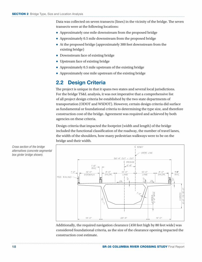
2.2 Design Criteria
The project is unique in that it spans two states and several local jurisdictions. For the bridge TS&L analysis, it was not imperative that a comprehensive list of all project design criteria be established by the two state departments of transportation (ODOT and WSDOT). However, certain design criteria did surface as fundamental or foundational criteria to determining the type size, and therefore construction cost of the bridge. Agreement was required and achieved by both agencies on these criteria.
Design criteria that impacted the footprint (width and length) of the bridge included the functional classification of the roadway, the number of travel lanes, the width of the shoulders, how many pedestrian walkways were to be on the bridge and their width.
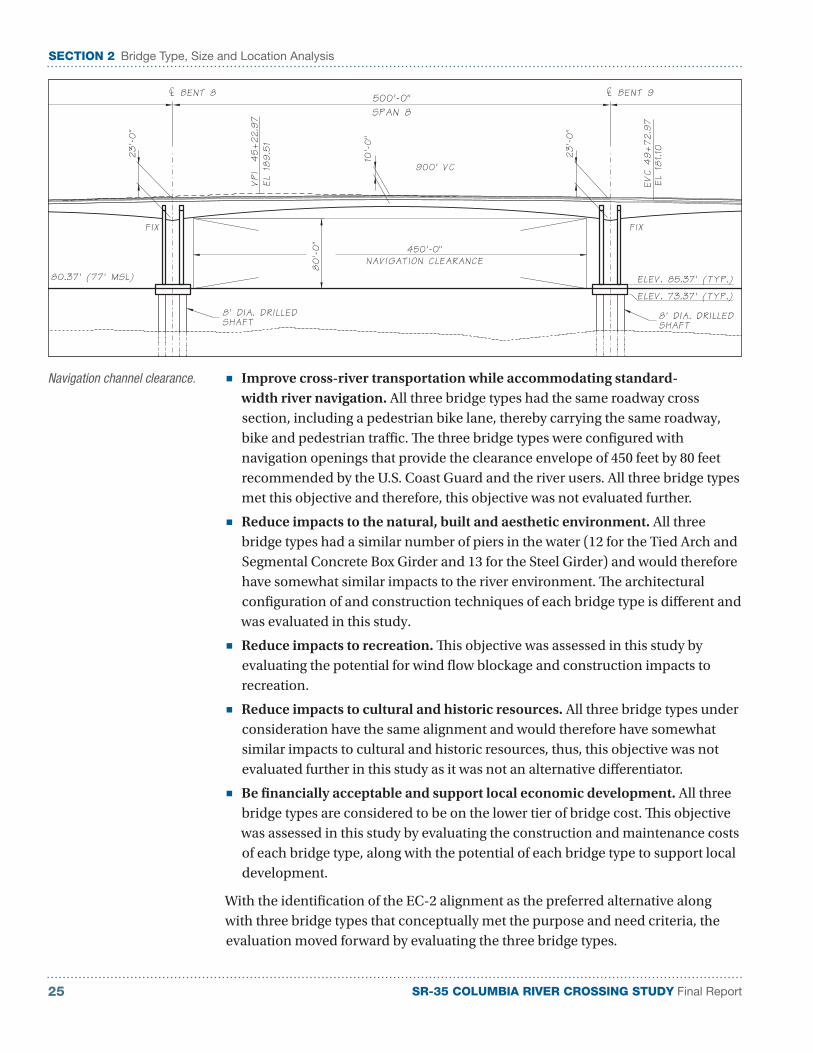
Additionally, the required navigation clearance (450 feet high by 80 feet wide) was considered foundational criteria, as the size of the clearance opening impacted the construction cost estimate.
Cross section of the bridge alternatives (concrete segmental box girder bridge shown).
SR-35 COLUMBIA RIVER CROSSING STUDY Final Report 19
SECTION 2 Bridge Type, Size and Location Analysis
Design criteria were summarized and discussed with the Project Management Team (PMT), which included representatives from ODOT, WSDOT and RTC at a meeting held on July 31, 2010.
The PMT provided direction on these criteria which enabled the remainder of the design criteria to be established.
The list of project design criteria is provided in Appendix B.
2.3 Navigation Survey Validation
As part of the draft EIS and Section 4(f) evaluation, a navigation baseline report (dated March 2003) was issued that summarized information gathered from surveyed river users and concluded:
“Historic commercial traffic through the SR-35 bridge has not encountered safety hazards resulting in loss of life or severe damage. However, modification or replacement of the bridge presents opportunities to improve conditions affecting navigation and thereby prepare for future growth in commercial and recreational traffic on the system. These opportunities include:
■ Provide a navigation channel under the bridge with a horizontal clearance equal to or greater than 450 feet
■ Provide a vertical clearance under the bridge of 80 feet above the full pool elevation of 77 feet mean sea level (MSL)
■ Ensure that the channel alignment allows tugs and barges to be aligned with the westerly winds”
As part of this analysis, river users were contacted to determine whether river use had changed since the time report. The findings from the 2003 Navigation Baseline Report were validated with the conclusion that fixed-span bridge alternatives must provide a navigation clearance opening of 450 feet (horizontal) by 80 feet (vertical) for river users.
In addition to validating the findings of the navigation baseline report, input was sought from barge and tow operators on the proposed pier configuration through the navigation channel.
The navigation survey validation memorandum is provided in Appendix C.
2.4 Environmental
Built Environment Considerations
The project site lies at a crossroads of transportation modes in the region. The SR-35 bridge provides highway connections to I-84 to the south and SR-14 to the north, though the bridge currently has a weight restriction that prohibits heavier vehicles from using the bridge. In addition, the travel lanes are substandard and functionally obsolete, at 9 feet-4.75 inches wide, restricting wide loads or requiring guided pilot vehicles. The proposed bridge would have standard width travel
SR-35 COLUMBIA RIVER CROSSING STUDY Final Report20
SECTION 2 Bridge Type, Size and Location Analysis
lanes and shoulders to allow all standard truck traffic to use the bridge without restriction.
Several barge companies and tourist vessels operate on the Columbia River and pass under the SR-35 bridge. The proposed navigation channel clearance under the main span has been set at 450 feet wide by 80 feet high, allowing for tows to safely transit the structure. In contrast, the existing bridge provides a 265-foot horizontal navigation clearance, with a lift span to provide vertical clearance.
The BNSF Railway Company operates a mainline track that parallels SR-14 on the Washington side. The vertical profile of the proposed structure has been set to provide the standard 22-foot vertical clearance required by the railroad.
Natural Environment Considerations
The natural environment in the project vicinity is dominated by the Columbia River and scenic beauty that it provides. With the project residing within the CGRNSA, portions of this project fall under the guidance of the Columbia River Gorge Commission’s Management Plan.
The management plan was amended to specifically address the portion of the proposed bridge within the general management area. The amendment addresses visual quality, historic design elements, and recreation and pedestrian/bicycle access. Under visual quality, the design of the bridge shall be visually unobtrusive and harmonious with the surrounding Gorge landscape and the Columbia River, be thin and open, have a consistent design character, and include ornamental elements. Historic design elements shall reflect historic design features of scenic area roadways and bridges and be incorporated shore to shore. The design shall include arches and/or other traditional structural forms in the bridge, historic style benches, lighting, and other pedestrian furnishings. The bridge shall include facilities for pedestrians and bicyclists that are wide enough to safely accommodate and encourage walking, bicycling, and other uses, provide multiple sitting and viewing areas with significant upstream and downstream views.
On November 15, 2010, the project team met with Jennifer Kaden, a staff member for the Columbia River Gorge Commission, to get the Commission’s perspective on the intent behind the amendment to the Gorge Management Plan that addressed the replacement of the bridge. The new bridge was to incorporate elements that reflected historic design features, but remained visually unobtrusive and harmonious with the surroundings. Information gathered from this meeting provided valuable direction for the development of several possible architectural themes that could be incorporated into the preliminary engineering of the three bridge alternatives.
The amendment to the Columbia River Gorge Commission’s Gorge Management Plan that addresses the river crossing is included in Appendix D.
Multnomah Falls typifies the scenic resources that abound in the Columbia River Gorge.
SR-35 COLUMBIA RIVER CROSSING STUDY Final Report 21
SECTION 2 Bridge Type, Size and Location Analysis
2.5 Bridge Aesthetics
During the initial stages of the stakeholder outreach, project staff met with Gorge Commission staff to get a first-hand sense of the intent of the Gorge Management Plan amendment. From this input, several concepts for the bridge’s architectural character were developed and discussed.
Since the site is dominated by natural forms – the water and mountains – a preference was given to sculpting the new bridge structural members to a theme of natural and organic form. Various climatic and light level conditions found in the Columbia River Gorge area were to be considered.
The existing bridge has a high level of transparency because the superstructure is a steel truss. The new bridge will have fixed spans, eliminating the need for the lift span by being high enough to clear the navigation channel. This means the new crossing will be further away from the water than the existing structure. This feature provides an opportunity to shape the structure in a manner that makes it look thinner than a low structure. The taller piers also provide an excellent medium to sculpt a natural form in a way that is unexpected and whose form harmonizes and evolves over time.
Design Workshop
A design workshop was held with the Bi-State Committee, key stakeholders and the project team on January 21, 2011. Participating groups included: WSDOT, ODOT, RTC, Counties of Skamania, Klickitat and Hood River, Cities of Bingen and Hood River, Port of Hood River, Mid Columbia Council of Governments, Mid Columbia Economic Development District, Columbia Gorge Windsurfing Association, and the tow operators.
This workshop provided project background and an update of work performed to date. In addition to the basic physical characteristics of the bridge, such as span lengths and vertical clearance, the architectural elements of the bridge were introduced and feedback was requested on concepts presented.
At the conclusion of the workshop, participants reached agreement on three major issues that provided direction for the project team to move forward. Those items of agreement included:
■ There are no aesthetic issues with moving the three bridge types forward. The group felt that the aesthetics of the alternatives fit their impression of what the bridges would look like.
■ The bridge must fit the community. The surrounding natural beauty is cherished and the bridge must not detract from it..
■ Apply architectural elements to the multi-use path and not necessarily the bridge girders and piers. The group acknowledged that the aesthetic treatment would be appreciated more from near views (pedestrian path or driver’s perspective), rather than views from either shore.
Architectural styles influence bridge aesthetics decisions.
The common expectation from the stakeholder groups was that the bridge design was to complement the site in an economically responsible manner.
SR-35 COLUMBIA RIVER CROSSING STUDY Final Report22
SECTION 2 Bridge Type, Size and Location Analysis
2.6 Recommended Preferred Bridge Alternative
Criteria and Weighting
The evaluation of the SR-35 bridge alternatives began with the concept study in 2001 that led to the draft EIS in 2004. The concept study and the resultant draft EIS successively screened alternative alignments and bridge types to arrive at the preferred alignment, EC-2 and three bridge type alternatives that met the minimum criteria established by the purpose and need.
The EC-2 alternative is directly adjacent to the west side of the existing bridge until a point north of the shipping channel, where it would shift slightly to the east to avoid the in-lieu fishing site on the Washington side. It will be grade separated from the railroad mainline on the Washington side. The SR-14 intersection will be signalized and widened to accommodate turn lanes. On the Oregon side, the alignment ties back into U.S. 30 at E. Marina Way.
Each of the three bridge types under consideration will provide a main span navigation clearance envelope that is 450 feet wide with a vertical clearance of 80 feet. The bridge types considered in this evaluation are:
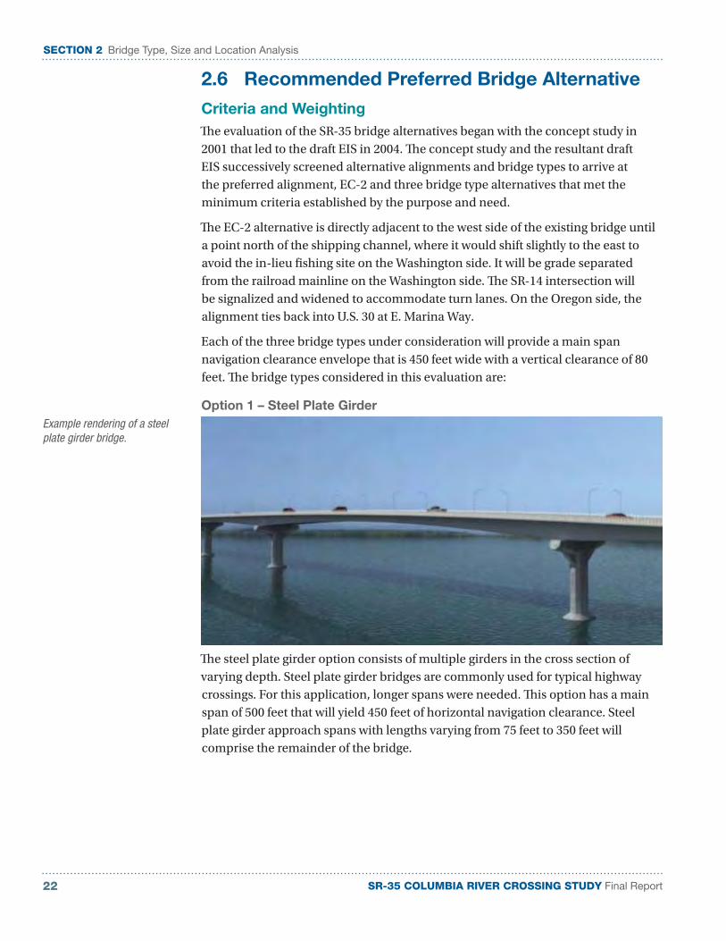
Option 1 – Steel Plate Girder
The steel plate girder option consists of multiple girders in the cross section of varying depth. Steel plate girder bridges are commonly used for typical highway crossings. For this application, longer spans were needed. This option has a main span of 500 feet that will yield 450 feet of horizontal navigation clearance. Steel plate girder approach spans with lengths varying from 75 feet to 350 feet will comprise the remainder of the bridge.
Example rendering of a steel plate girder bridge.
23
SR
-35 C
OLU
MB
IA R
IVE
R C
RO
SS
ING
ST
UD
Y D
raft
Sum
mar
y R
epor
t
Plan
vie
w o
f the
pre
ferre
d al
ignm
ent (
EC-2
), al
ong
with
pro
file
view
s an
d cr
oss
sect
ions
of t
he th
ree
brid
ge a
ltern
ativ
es s
tudi
ed.
SE
CT
ION
2 B
ridge
Typ
e, S
ize
and
Loc
atio
n A
naly
sis


SR-35 COLUMBIA RIVER CROSSING STUDY Final Report 24
SECTION 2 Bridge Type, Size and Location Analysis
Option 2 – Concrete Segmental Box Girder
The segmental box girder option is a single box girder of varying depth constructed of concrete. This option has a main span of 500 feet that will yield 450 feet of horizontal navigation clearance. Segmental box girder approach spans with lengths varying from 100 feet to 400 feet will comprise the remainder of the bridge. The I-205 Glenn L. Jackson Memorial Bridge over the Columbia River is an example of a concrete segmental box girder bridge.
Option 3 – Steel Tied Arch
The steel tied arch main span option is a single-span steel network tied arch that has a main span of 530 feet that will yield 450 feet of horizontal navigation clearance. Steel plate girder approach spans with lengths varying from 100 feet to 300 feet will comprise the remainder of the bridge. The Fremont Bridge, spanning the Willamette River in downtown Portland, is an example of a steel tied arch bridge.
The objectives in the purpose and need statement were the basis for the screening that took place in the studies leading to the draft EIS and continue to guide the decision making in this TS&L analysis. The following discusses each of the objectives and how they were considered in this analysis:
Example rendering of a concrete segmental box girder bridge.
Example rendering of a steel tied arch bridge.
SR-35 COLUMBIA RIVER CROSSING STUDY Final Report25
SECTION 2 Bridge Type, Size and Location Analysis
■ Improve cross-river transportation while accommodating standard-width river navigation. All three bridge types had the same roadway cross section, including a pedestrian bike lane, thereby carrying the same roadway, bike and pedestrian traffic. The three bridge types were configured with navigation openings that provide the clearance envelope of 450 feet by 80 feet recommended by the U.S. Coast Guard and the river users. All three bridge types met this objective and therefore, this objective was not evaluated further.
■ Reduce impacts to the natural, built and aesthetic environment. All three bridge types had a similar number of piers in the water (12 for the Tied Arch and Segmental Concrete Box Girder and 13 for the Steel Girder) and would therefore have somewhat similar impacts to the river environment. The architectural configuration of and construction techniques of each bridge type is different and was evaluated in this study.
■ Reduce impacts to recreation. This objective was assessed in this study by evaluating the potential for wind flow blockage and construction impacts to recreation.
■ Reduce impacts to cultural and historic resources. All three bridge types under consideration have the same alignment and would therefore have somewhat similar impacts to cultural and historic resources, thus, this objective was not evaluated further in this study as it was not an alternative differentiator.
■ Be financially acceptable and support local economic development. All three bridge types are considered to be on the lower tier of bridge cost. This objective was assessed in this study by evaluating the construction and maintenance costs of each bridge type, along with the potential of each bridge type to support local development.
With the identification of the EC-2 alignment as the preferred alternative along with three bridge types that conceptually met the purpose and need criteria, the evaluation moved forward by evaluating the three bridge types.
Navigation channel clearance.
SR-35 COLUMBIA RIVER CROSSING STUDY Final Report 26
SECTION 2 Bridge Type, Size and Location Analysis
From discussions and input from the PMT and Bi-State Committee, seven primary categories of evaluation criteria emerged. An evaluation matrix was then developed to compare the three bridge types against the evaluation criteria and weighting.
The evaluation criteria was used to differentiate and identify trade-offs between the three bridge alternatives. The associated rationale for decision making is discussed below:
Design criteria: A project-specific design criteria was developed to define applicable project design criteria based not only on published engineering design standards from both the ODOT and WSDOT for the crossing structure, but also the context of the end user. One design criteria aspect that was not considered in that document was the quality of the load path redundancy and fracture critical nature of the structure. Load path redundancy means that there are more than two members or load paths on the bridge, increasing the reliability of the bridge to carry the intended loads. A fracture critical member is defined as a “component in tension whose failure is expected to result in the collapse of the bridge or the inability of the bridge to perform its function.”
The steel plate girder and the concrete segmental box girder options are typically considered load path redundant. The steel tied arch main span has a tie girder that is considered non-redundant and could be considered fracture critical unless certain measures are undertaken.
Cost: A relative determination of construction cost, long-term maintenance and the ease of inspection was evaluated. Typical square foot construction costs were used to develop conceptual-level cost estimates for each bridge option.
To evaluate long-term maintenance or life cycle costs, a concrete superstructure is considered to score better due to its durability and lack of required painting of the structure. Steel structures can be fabricated from weathering steel and overall painting is therefore not required when weathering steel is used. However, a protective paint system is still required for joints and other particularly exposed areas of a weathering steel bridge.
Ease of inspection was evaluated considering that structures with larger members and overall ease of access score better. The multiple steel girder and segmental concrete superstructures have larger accessible members. The tied arch has generally smaller members and the suspenders can be considered to be an obstruction to commonly used bridge inspection equipment.
Conversations with the PMT and other stakeholders indicated that cost, specifically the construction cost, is the most important criteria to be evaluated.
Construction: The relative construction duration, potential for construction conflict and opportunity for the local economy to benefit from the construction were evaluated. While detailed construction schedules were not developed, items such as fabrication time and erection time were considered in evaluating this criterion.
Bridge construction will require barges and heavy cranes.
SR-35 COLUMBIA RIVER CROSSING STUDY Final Report27
SECTION 2 Bridge Type, Size and Location Analysis
In particular, the specialty aspects of the fabrication of the steel tied arch were considered to take the most time.
The potential for construction conflict with river users was evaluated considering that more piers in the water or the extended use of barge operations for construction would cause conflict.
The potential for the regional economy to benefit from the bridge construction took several forms. The more common construction methods of the steel plate girder and the concrete segmental box girder options may engage regional contractors that employ Hood River/Bingen residents. From the standpoint of materials, ready-mixed concrete is the only material that is typically supplied from the adjacent community. Each of these factors caused the steel plate girder and the concrete segmental box girder options to score higher.
Risk: The relative risk of cost escalation potential, design and bid risk of a less common structure type, schedule risk due to fabrication and erection and overall ease of construction were evaluated. It is difficult, if not impossible, to predict the potential for cost escalation among the structure types. In past years, though, concrete has typically exhibited more stability and consistency of cost, and therefore the concrete segmental girder scored higher.
The design and bid risks of a less common structure type are similar in that the more common structure types of the steel plate girder and the concrete segmental box girder options scored higher. The schedule risk due to fabrication and erection was evaluated considering the additional time needed for steel procurement and fabrication of the tied arch option, causing this option to score lower.
The aspect of ease of construction was used to evaluate the use of standard construction methods and the ability of a contractor to generate a cost-competitive bid. The less standard nature of construction of the tied arch caused it to score lower in this criteria.
Bridge aesthetics: Relative aesthetic aspects, such as conformance with the Gorge Management Plan Amendment, proportion and scale from shore, patron experience on the bridge, ability to accommodate the public desire of a single larger overlook and the ability to accommodate the public desire of a simple and non-iconic structure were evaluated.
The Gorge Management Plan Amendment includes these desired aspects of the bridge: “thin and open structural design,” “allows views through it,” “incorporates historic themes such as arches from shore to shore.” The use of the single tied arch is considered to contradict all of these desired aspects, which causes the tied arch to score lower in this criteria.
Conversations with the PMT and other stakeholders have indicated that the proportion and scale from shore should be evaluated considering that the structure doesn’t overwhelm the natural landscape. Visualizations presented at the design
SR-35 COLUMBIA RIVER CROSSING STUDY Final Report 28
SECTION 2 Bridge Type, Size and Location Analysis
workshop have shown that all structure types are relatively unobtrusive when viewed from a distance.
The patron experience on the bridge is evaluated by considering the view from the sidewalk. The network cables of the tied arch structure can affect the view from the main span, thereby causing the tied arch to score lower in this criterion.
All of the structure types can accommodate a larger single overlook, but two smaller overlooks (straddling the main span) provide a richer viewing experience and are proposed.
The ability to accommodate the public desire of a simple and non-iconic structure was evaluated considering that both of the girder structures were considered simple and typical and that the arch is often considered as an iconic structure.
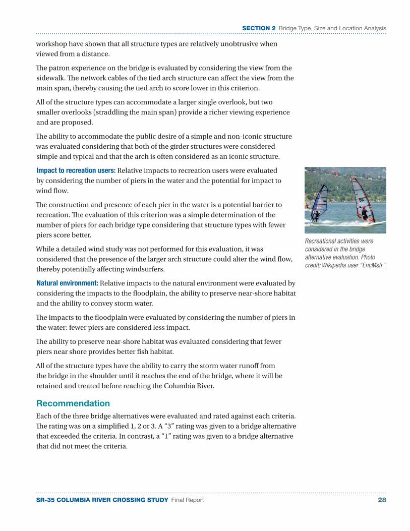
Impact to recreation users: Relative impacts to recreation users were evaluated by considering the number of piers in the water and the potential for impact to wind flow.
The construction and presence of each pier in the water is a potential barrier to recreation. The evaluation of this criterion was a simple determination of the number of piers for each bridge type considering that structure types with fewer piers score better.
While a detailed wind study was not performed for this evaluation, it was considered that the presence of the larger arch structure could alter the wind flow, thereby potentially affecting windsurfers.
Natural environment: Relative impacts to the natural environment were evaluated by considering the impacts to the floodplain, the ability to preserve near-shore habitat and the ability to convey storm water.
The impacts to the floodplain were evaluated by considering the number of piers in the water: fewer piers are considered less impact.
The ability to preserve near-shore habitat was evaluated considering that fewer piers near shore provides better fish habitat.
All of the structure types have the ability to carry the storm water runoff from the bridge in the shoulder until it reaches the end of the bridge, where it will be retained and treated before reaching the Columbia River.
Recommendation
Each of the three bridge alternatives were evaluated and rated against each criteria. The rating was on a simplified 1, 2 or 3. A “3” rating was given to a bridge alternative that exceeded the criteria. In contrast, a “1” rating was given to a bridge alternative that did not meet the criteria.
Recreational activities were considered in the bridge alternative evaluation. Photo credit: Wikipedia user “EncMstr”.
SR-35 COLUMBIA RIVER CROSSING STUDY Final Report29
SECTION 2 Bridge Type, Size and Location Analysis
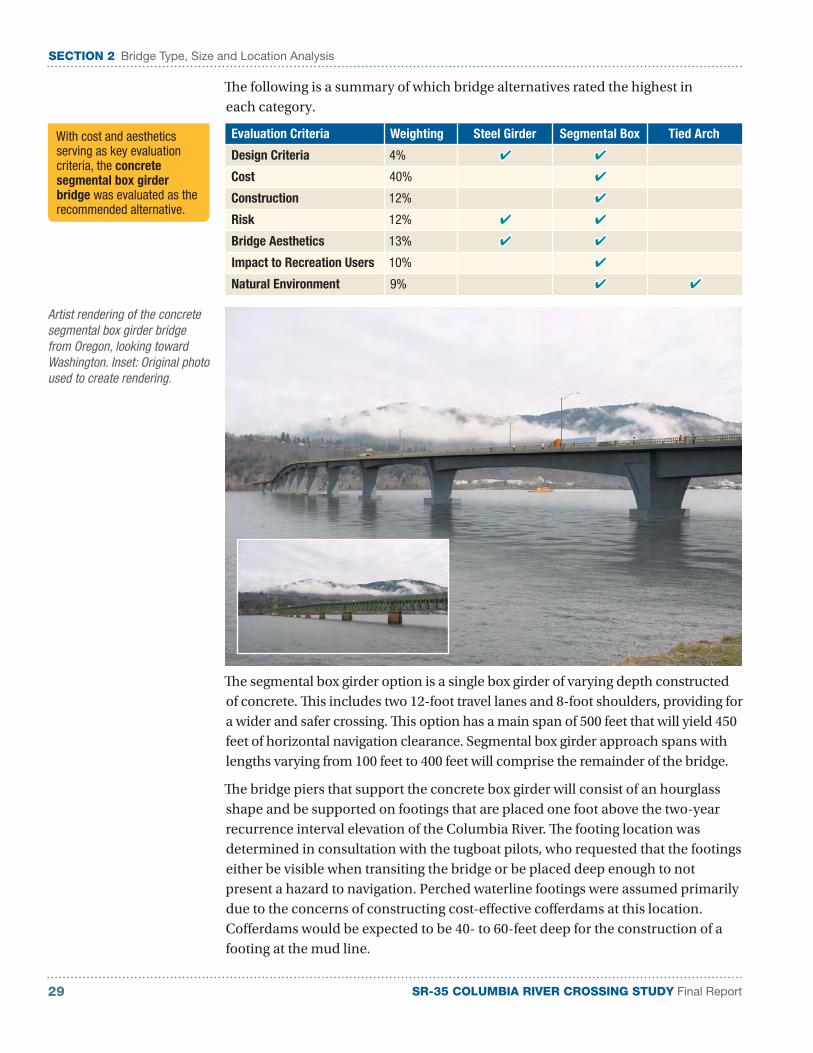
The following is a summary of which bridge alternatives rated the highest in each category.
Evaluation Criteria Weighting Steel Girder Segmental Box Tied Arch
Design Criteria 4% ✔ ✔
Cost 40% ✔
Construction 12% ✔
Risk 12% ✔ ✔
Bridge Aesthetics 13% ✔ ✔
Impact to Recreation Users 10% ✔
Natural Environment 9% ✔ ✔
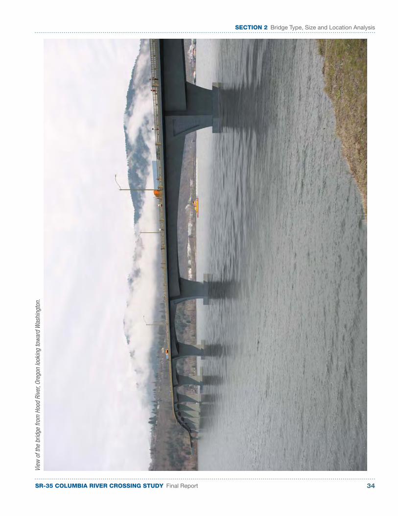
Artist rendering of the concrete segmental box girder bridge from Oregon, looking toward Washington. Inset: Original photo used to create rendering.
The segmental box girder option is a single box girder of varying depth constructed of concrete. This includes two 12-foot travel lanes and 8-foot shoulders, providing for a wider and safer crossing. This option has a main span of 500 feet that will yield 450 feet of horizontal navigation clearance. Segmental box girder approach spans with lengths varying from 100 feet to 400 feet will comprise the remainder of the bridge.
The bridge piers that support the concrete box girder will consist of an hourglass shape and be supported on footings that are placed one foot above the two-year recurrence interval elevation of the Columbia River. The footing location was determined in consultation with the tugboat pilots, who requested that the footings either be visible when transiting the bridge or be placed deep enough to not present a hazard to navigation. Perched waterline footings were assumed primarily due to the concerns of constructing cost-effective cofferdams at this location. Cofferdams would be expected to be 40- to 60-feet deep for the construction of a footing at the mud line.
With cost and aesthetics serving as key evaluation criteria, the concrete segmental box girder bridge was evaluated as the recommended alternative.
SR-35 COLUMBIA RIVER CROSSING STUDY Final Report 30
SECTION 2 Bridge Type, Size and Location Analysis
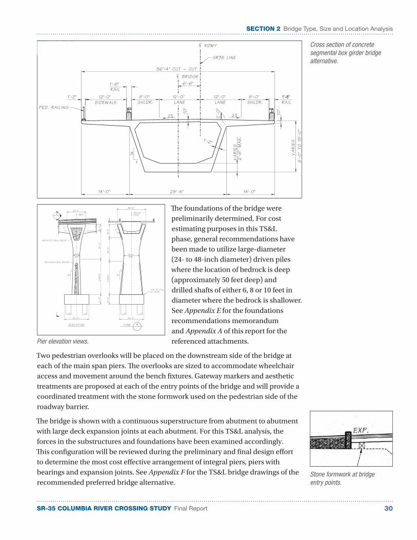
The foundations of the bridge were preliminarily determined. For cost estimating purposes in this TS&L phase, general recommendations have been made to utilize large-diameter (24- to 48-inch diameter) driven piles where the location of bedrock is deep (approximately 50 feet deep) and drilled shafts of either 6, 8 or 10 feet in diameter where the bedrock is shallower. See Appendix E for the foundations recommendations memorandum and Appendix A of this report for the referenced attachments.
Two pedestrian overlooks will be placed on the downstream side of the bridge at each of the main span piers. The overlooks are sized to accommodate wheelchair access and movement around the bench fixtures. Gateway markers and aesthetic treatments are proposed at each of the entry points of the bridge and will provide a coordinated treatment with the stone formwork used on the pedestrian side of the roadway barrier.
The bridge is shown with a continuous superstructure from abutment to abutment with large deck expansion joints at each abutment. For this TS&L analysis, the forces in the substructures and foundations have been examined accordingly. This configuration will be reviewed during the preliminary and final design effort to determine the most cost effective arrangement of integral piers, piers with bearings and expansion joints. See Appendix F for the TS&L bridge drawings of the recommended preferred bridge alternative.
Stone formwork at bridge entry points.
Cross section of concrete segmental box girder bridge alternative.
Pier elevation views.
SR-35 COLUMBIA RIVER CROSSING STUDY Final Report31
SECTION 2 Bridge Type, Size and Location Analysis
Design Refinement
With the evaluation of the three bridge alternatives concluding with the segmental concrete box girder bridge as the recommended preferred bridge alternative, analysis was continued and refined on the preferred alternative in several areas, such as storm water, bridge hydraulics, right-of-way and construction.
Storm Water
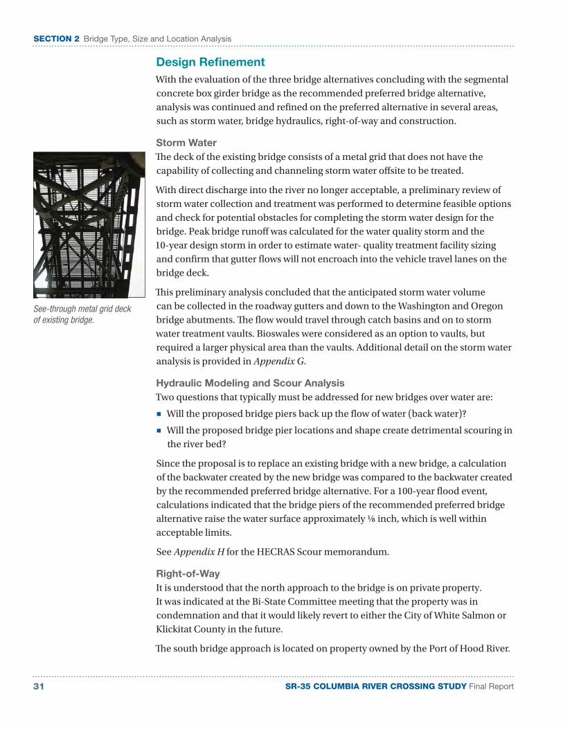
The deck of the existing bridge consists of a metal grid that does not have the capability of collecting and channeling storm water offsite to be treated.
With direct discharge into the river no longer acceptable, a preliminary review of storm water collection and treatment was performed to determine feasible options and check for potential obstacles for completing the storm water design for the bridge. Peak bridge runoff was calculated for the water quality storm and the 10-year design storm in order to estimate water- quality treatment facility sizing and confirm that gutter flows will not encroach into the vehicle travel lanes on the bridge deck.
This preliminary analysis concluded that the anticipated storm water volume can be collected in the roadway gutters and down to the Washington and Oregon bridge abutments. The flow would travel through catch basins and on to storm water treatment vaults. Bioswales were considered as an option to vaults, but required a larger physical area than the vaults. Additional detail on the storm water analysis is provided in Appendix G.
Hydraulic Modeling and Scour Analysis
Two questions that typically must be addressed for new bridges over water are:
■ Will the proposed bridge piers back up the flow of water (back water)?
■ Will the proposed bridge pier locations and shape create detrimental scouring in the river bed?
Since the proposal is to replace an existing bridge with a new bridge, a calculation of the backwater created by the new bridge was compared to the backwater created by the recommended preferred bridge alternative. For a 100-year flood event, calculations indicated that the bridge piers of the recommended preferred bridge alternative raise the water surface approximately ⅛ inch, which is well within acceptable limits.
See Appendix H for the HECRAS Scour memorandum.
Right-of-Way
It is understood that the north approach to the bridge is on private property. It was indicated at the Bi-State Committee meeting that the property was in condemnation and that it would likely revert to either the City of White Salmon or Klickitat County in the future.
The south bridge approach is located on property owned by the Port of Hood River.
See-through metal grid deck of existing bridge.
SR-35 COLUMBIA RIVER CROSSING STUDY Final Report 32
SECTION 2 Bridge Type, Size and Location Analysis
Construction
For this TS&L analysis, it has been assumed that the superstructure will use cast-in-place segmental construction. This is due primarily to the large weight and size of the segments. The bridge will be constructed adjacent to the existing bridge, which will continue to carry the traffic during construction. There will be short periods of time where traffic staging will be performed to make the approach connections to the bridge, but it is expected that construction activities will not generally affect the traffic conditions in Hood River or White Salmon. It is expected that the bridge construction will take two to three years. Once the foundations and piers are constructed, a contractor may choose to construct the superstructure at multiple locations to decrease the construction duration.
Artist Rendering
Two artist renderings are provided of the recommended preferred bridge alternative.

SR-35 COLUMBIA RIVER CROSSING STUDY Final Report33
SECTION 2 Bridge Type, Size and Location AnalysisVi
ew fr
om th
e pe
dest
rian
path
, loo
king
tow
ard
one
of th
e tw
o ou
tlook
s.
SR-35 COLUMBIA RIVER CROSSING STUDY Final Report 34
SECTION 2 Bridge Type, Size and Location Analysis
View
of t
he b
ridge
from
Hoo
d Ri
ver,
Oreg
on lo
okin
g to
war
d W
ashi
ngto
n.
SR-35 COLUMBIA RIVER CROSSING STUDY Final Report35
SECTION 2 Bridge Type, Size and Location Analysis
This page left intentionally blank.
SR-35 COLUMBIA RIVER CROSSING STUDY Final Report 36
SECTION 3 Project Cost Estimate
SECTION 3
Project Cost Estimate
With the determination of the concrete segmental box girder as the recommended alternative, the construction cost estimate range and then an overall project cost estimate range was prepared for that structure type.
The construction cost estimate was developed by calculating the quantities from the TS&L drawings and then using a combination of historical unit prices and unit price analysis to develop the estimated construction cost. In addition to the bridge construction cost, other costs such as removal of the existing bridge and sales tax are included in the overall cost estimate range.
In present day (2011) dollars, the project’s overall cost estimate range is $190 million to $205 million. Besides the bridge construction cost, this range includes other items such as the cost for the roadway approaches, existing bridge removal, the storm water collection and treatment system, right-of way, engineering, sales tax (Washington side only) and a contingency allowance.
If bridge construction were to start in year 2020, and assuming an inflation rate of four percent, the project’s overall cost estimate range would be $270 million to $290 million.
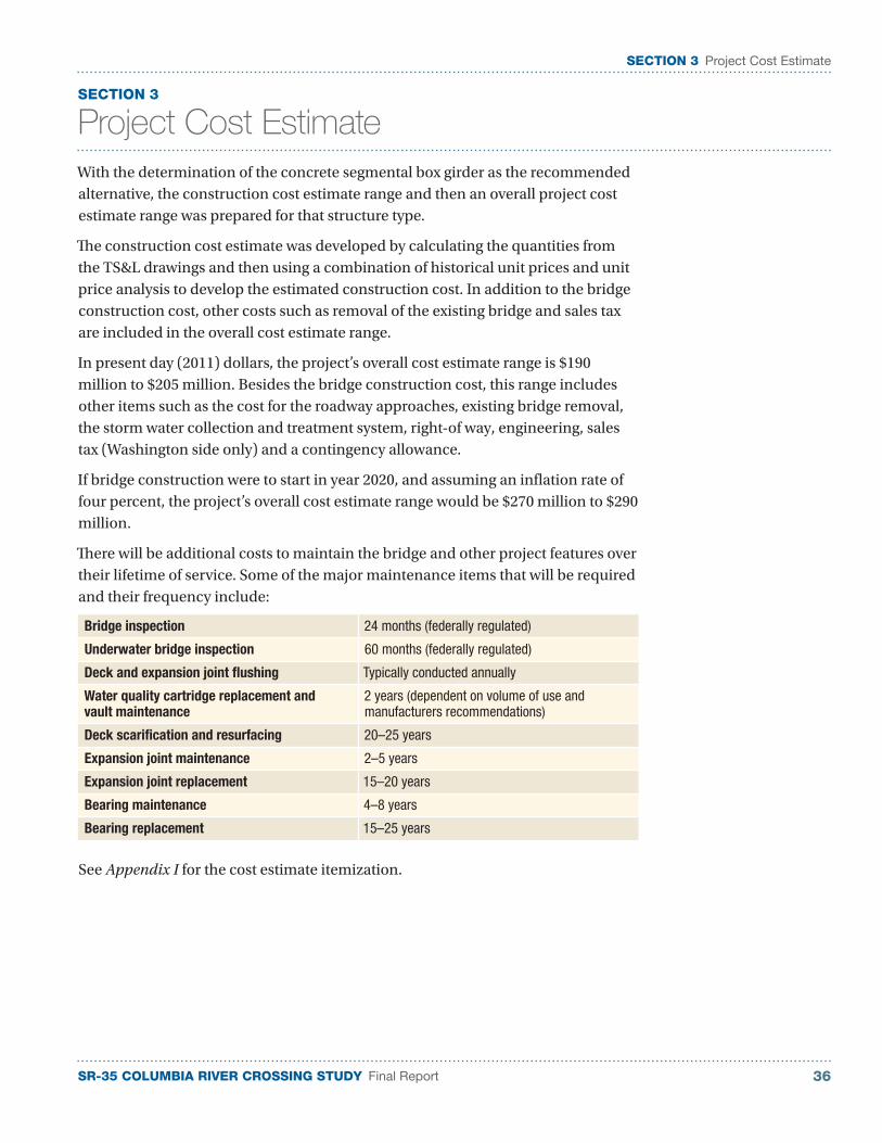
There will be additional costs to maintain the bridge and other project features over their lifetime of service. Some of the major maintenance items that will be required and their frequency include:
Bridge inspection 24 months (federally regulated)
Underwater bridge inspection 60 months (federally regulated)
Deck and expansion joint flushing Typically conducted annually
Water quality cartridge replacement and vault maintenance
2 years (dependent on volume of use and manufacturers recommendations)
Deck scarification and resurfacing 20–25 years
Expansion joint maintenance 2–5 years
Expansion joint replacement 15–20 years
Bearing maintenance 4–8 years
Bearing replacement 15–25 years
See Appendix I for the cost estimate itemization.

SR-35 COLUMBIA RIVER CROSSING STUDY Final Report37
SECTION 3 Project Understanding and Approach
This page left intentionally blank.

SR-35 COLUMBIA RIVER CROSSING STUDY Final Report 38
SECTION 4 Economic Analysis
SECTION 4
Economic Analysis
An economic analysis was performed to determine the role that the existing crossing plays in the regional economy, the shortcomings of the existing bridge to meet transportation needs, and the potential benefits of a proposed new bridge.
The analysis revealed that the fundamental role of the bridge is to connect the communities of White Salmon/Bingen with Hood River, allowing the communities to share a common workforce, retail services and public services. The bridge is the only link that makes that connection for 20 miles in either direction. The bridge:
■ Provides residents and businesses with cross-river commuting access to Washington and Oregon. Businesses are dependent on access to workers on both sides of the bridge. About 10 to 15 percent of daily trips on the bridge are for commuting to work.
■ Supports the regional economy. Hood River is the economic center of the region. Residents of Washington depend on the bridge to shop and conduct business in Hood River. Businesses in Hood River depend on residents of Washington for customers.
■ Supports the movement of goods and services between Washington and Oregon. The bridge allows relatively easy freight movement across the river, which gives manufacturers and producers some choice in where to have materials processed. Most freight goods that cross the bridge are wood products and fruit for processing, use within the region, or for export outside of the region.
■ Provides access to recreational attractions and improves tourism within this region. Visitors to the region use the bridge to access attractions or recreational opportunities on both sides of the river, as well as the retail and accommodations services available primarily in Hood River.
■ Provides access for emergency services between Washington and Oregon. The bridge also allows local emergency-service providers with the opportunity to combine resources and support each other
The analysis concluded that the region’s transportation patterns and economy are driven to a great extent, by the current conditions on the bridge. The following concerns were identified:
■ The narrowness of the bridge frightens people crossing the bridge, both local resident and visitors alike.
■ The narrowness of the bridge causes problems for schools and transit agencies: minor damage to vehicles (such as scrapes or broken side-view mirrors) and worries about passenger safety.
■ Motorcycles have a hard time riding on the grating of the bridge.
■ Pedestrians and bicycles cannot cross the bridge.
Safety concerns have been raised over the narrowness of the existing bridge.
SR-35 COLUMBIA RIVER CROSSING STUDY Final Report39
SECTION 4 Economic Analysis
■ The weight limit for vehicles crossing the bridge is 80,000 pounds. This weight limit and the narrowness of the bridge impedes efficient freight movement.
■ The Hood River Bridge is one of the most challenging bridges on the Columbia River system for river traffic
The research and community outreach in this project suggest a replacement Hood River Bridge would provide or improve:
■ Access between Hood River, Oregon, and White Salmon/Bingen, Washington, beyond the existing bridge’s estimated remaining useful life of 25 years. A new bridge would have a design lifetime in excess of 75 years.
■ Travel time within the region. Increases in the speed of bridge crossings would reduce the time it takes to cross the bridge, resulting in annual savings of about $350,000. Relieving congestion would result in reduced fuel consumption, saving about $90,000 per year.
■ Freight mobility within the region. A new bridge with an increase in the maximum freight load allowed could attract more freight users to the region and provide a savings of around $125,000 per year.
■ Safety for bridge users. Improving safety on the bridge would help people in the region feel more comfortable when crossing the bridge. Replacement would provide an annual savings, from fewer broken mirrors, between $40,000 and $80,000 and $100,000 to $300,000 annually from fewer major incidents.
■ Multimodal transportation options to cross the bridge. The narrowness of the existing bridge eliminates most multimodal transportation options. With standard-width lanes, shoulders and a pedestrian path, a new bridge would promote the use of multimodal transportation options. The architectural features along the pedestrian path, as well as the two outlooks at the main span would invite pedestrians and bicyclists to enjoy the vistas. The standard lane and shoulder widths would improve the transit bus experience and likely increase ridership demand.
■ Tourism. A replacement bridge would benefit bicycle and other tourism, making it easier for visitors to cross the river.
■ Environmental quality. The replacement bridge would reduce or eliminate storm water runoff.
■ Safety for river traffic. This bridge is one of the most challenging on the Columbia River system for barge operators. Although there have been few barge strikes on the bridge, there is potential for a serious barge incident that could involve loss of life, negative environmental impacts (depending on the goods on the barge), and could significantly damage the bridge.
The replacement of the existing bridge requires a large public infrastructure project, and as such, is complicated and expensive. The feasibility of replacing the current bridge will depend in large part on the cost to build the replacement bridge, the economic benefits of replacement, and the ability to finance a replacement bridge.
SR-35 COLUMBIA RIVER CROSSING STUDY Final Report 40
SECTION 4 Economic Analysis
Users of a replacement bridge would most likely be willing to pay tolls that would cover about one-third of the amortized cost of the replacement bridge. In other words, the personal value that travelers crossing a replacement bridge would gain would not be great enough to make them willing to increase tolls to a level where they would fully pay for a replacement bridge.
The economics analysis and the focus group meeting finding strongly suggest that a replacement bridge will not be built in the near term, if:
1. The old bridge continues to function (albeit inadequately), and;
2. No outside state or federal funding gets allocated to the project.
Attracting such funding is supported by reasonable arguments about benefits that go beyond those to local users of the bridge, residents, and businesses. And reasonable arguments do exist.
The full report on the economic analysis is included in Appendix J.
SR-35 COLUMBIA RIVER CROSSING STUDY Final Report41
SECTION 4 Economic Analysis
This page left intentionally blank.

SR-35 COLUMBIA RIVER CROSSING STUDY Final Report 42
SECTION 5 Updated Final EIS Scope of Services
SECTION 5
Updated Final EIS Scope of Services
All federally funded projects must follow an evaluation process outlined in the National Environmental Policy Act (NEPA). The NEPA process includes a draft environmental impact statement (EIS) with public comment and a final EIS. The pre-construction NEPA process concludes with the Record of Decision (ROD), which states which alternative will be constructed. With the draft EIS and the preliminary engineering complete, the next step in the process is the final EIS. Although funding is unsecured at this time, in preparation for the final EIS phase, a scope of services outline has been developed that lists the activities and areas of further study needed to prepare for a ROD.
This scope of services is a multidisciplinary effort to ensure general environmental, engineering, and transportation analysis required are accounted for. The scope of services concludes with the federal ROD.
The total estimated cost for the final EIS and preliminary engineering phase of work is $1,840,000 to $2,240,000 depending on when the work is performed. The cost estimate assumes the work begins during the 2011–2016 timeframe. The cost is expected to increase over time due to inflation.
The final EIS scope of services is in Appendix K.

SR-35 COLUMBIA RIVER CROSSING STUDY Final Report43
SECTION 5 Updated Final EIS Scope of Services
This page left intentionally blank.