sst from suomi-npp viirs: algorithm development and uncertainty estimation peter j minnett, robert h...
TRANSCRIPT

SST from Suomi-NPP VIIRS: Algorithm Development And
Uncertainty Estimation
Peter J Minnett, Robert H Evans, Kay Kilpatrick, Guillermo Podestá, Elizabeth Williams, Goshka Szczodrak, Miguel Izaguirre, Sue Walsh &
Michael Reynolds*
Rosenstiel School of Marine and Atmospheric Science, University of Miami
*Remote Measurements and Research Co., Seattle
Outline
Overview of VIIRS characteristics relevant for SST retrievals.
Form of the atmospheric correction algorithms.
Uncertainties:– comparisons vs drifting buoys.– comparisons vs ship radiometers.
Future directions.
S-NPP Search for new S-NPP logo…. ??

IntroductionVIIRS is the first of a new class of satellite radiometer, using design elements from MODIS and SeaWiFS.
At least two more VIIRS will be flown on the NOAA JPSS satellites replacing the AVHRRs on the NOAA-n polar orbiters.
The European radiometer to replace the AVHRRs on MetOp-A and MetOp-B, called METimage, will have a similar optical design, but will have SST channels more similar to MODIS.

Suomi NPP• Launched on 28 October, 2011.• Equator crossing - 1:30 p.m. • Altitude of 824 km. • 16-day repeat cycle
Five key instruments: • Advanced Technology Microwave Sounder (ATMS)• Cross-track Infrared Sounder (CrIS) • Ozone Mapping and Profiler Suite (OMPS)• Clouds and the Earth's Radiant Energy System (CERES)• Visible Infrared Imaging Radiometer Suite (VIIRS)
Photo courtesy Ball Aerospace.

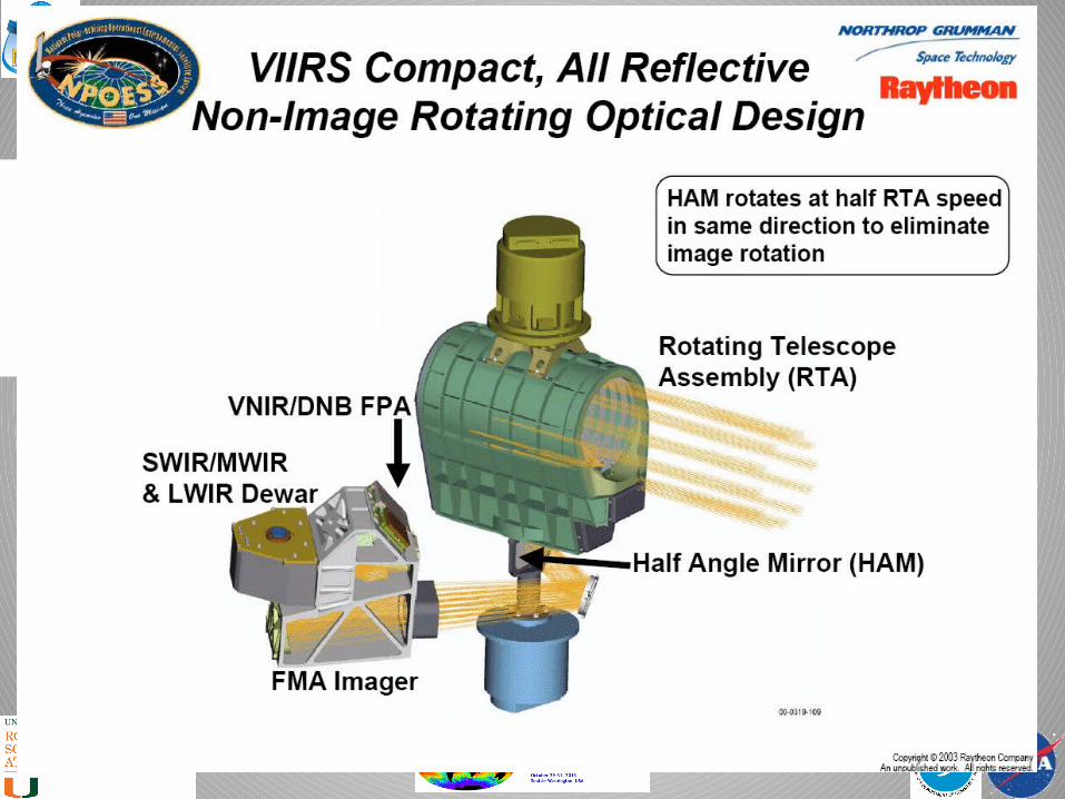
VIIRS• Rotating telescope with “Half-Angle Mirror” fore-
optics. • Spectral Bands:
– Visible/ Near IR: 9 plus Day/Night Band
– Mid-Wave IR: 8
– Long-Wave IR: 4
• Imaging Optics: 18.4 cm Aperture.• 114 cm Focal Length. • Scan Range of earth view: ±56º from nadir.• Swath width: 3000 km.

VIIRS Components
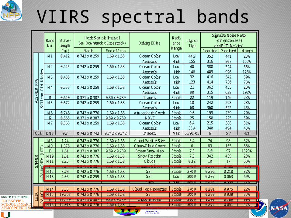
VIIRS spectral bands
Nadir End of Scan Required Predicted MarginM1 0.412 0.742 x 0.259 1.60 x 1.58 Ocean Color Low 44.9 352 441 25%
Aerosols High 155 316 807 155%M2 0.445 0.742 x 0.259 1.60 x 1.58 Ocean Color Low 40 380 524 38%
Aerosols High 146 409 926 126%M3 0.488 0.742 x 0.259 1.60 x 1.58 Ocean Color Low 32 416 542 30%
Aerosols High 123 414 730 76%M4 0.555 0.742 x 0.259 1.60 x 1.58 Ocean Color Low 21 362 455 26%
Aerosols High 90 315 638 102%I1 0.640 0.371 x 0.387 0.80 x 0.789 Imagery Single 22 119 146 23%M5 0.672 0.742 x 0.259 1.60 x 1.58 Ocean Color Low 10 242 298 23%
Aerosols High 68 360 522 45%M6 0.746 0.742 x 0.776 1.60 x 1.58 Atmospheric Corr'n Single 9.6 199 239 20%I2 0.865 0.371 x 0.387 0.80 x 0.789 NDVI Single 25 150 225 50%M7 0.865 0.742 x 0.259 1.60 x 1.58 Ocean Color Low 6.4 215 388 81%
Aerosols High 33.4 340 494 45%DNB 0.7 0.742 x 0.742 0.742 x 0.742 Imagery Var. 6.70E-05 6 5.7 -5%
M8 1.24 0.742 x 0.776 1.60 x 1.58 Cloud Particle Size Single 5.4 74 98 32%M9 1.378 0.742 x 0.776 1.60 x 1.58 Cirrus/Cloud Cover Single 6 83 155 88%I3 1.61 0.371 x 0.387 0.80 x 0.789 Binary Snow Map Single 7.3 6.0 97 1523%
M10 1.61 0.742 x 0.776 1.60 x 1.58 Snow Fraction Single 7.3 342 439 28%M11 2.25 0.742 x 0.776 1.60 x 1.58 Clouds Single 0.12 10 17 66%I4 3.74 0.371 x 0.387 0.80 x 0.789 Imagery Clouds Single 270 K 2.500 0.486 415%
M12 3.70 0.742 x 0.776 1.60 x 1.58 SST Single 270 K 0.396 0.218 82%M13 4.05 0.742 x 0.259 1.60 x 1.58 SST Low 300 K 0.107 0.063 69%
Fires High 380 K 0.423 0.334 27%
M14 8.55 0.742 x 0.776 1.60 x 1.58 Cloud Top Properties Single 270 K 0.091 0.075 22%M15 10.763 0.742 x 0.776 1.60 x 1.58 SST Single 300 K 0.070 0.038 85%I5 11.450 0.371 x 0.387 0.80 x 0.789 Cloud Imagery Single 210 K 1.500 0.789 90%
M16 12.013 0.742 x 0.776 1.60 x 1.58 SST Single 300 K 0.072 0.051 42%
Driving EDRsRadi-ance
Range
Ltyp or Ttyp
Signal to Noise Ratio(dimensionless)
or NET (Kelvins)
CCD
Horiz Sample Interval(km Downtrack x Crosstrack)
Band No.
Wave-length (m)
VIS
/NIR
FPA
Sili
con
PIN
Dio
des
S/M
WIR
PV
HgC
dTe
(HC
T)P
V H
CT
LWIR

VIIRS SST RSRs

VIIRS pixel aggregation
GSD: Ground Sampling DistanceHSI: Horizontal Sampling Interval

VIIRS vs MODIS spatial resolution
From http://www.ipo.noaa.gov/ams/2010/posters/AGU_AMS-RAY_NGAS-VIIRSHeritageSystems-SNODGRASS_GUENTHER_ANDREAS-WE_PRINT-PR.pdf

Miami decision-tree cloud mask

VIIRS Atmospheric Correction AlgorithmsMiami V6:
• SST2b = a0 + a1T11 + a2(T11 – T12) Tsfc + a3(T11-T12) Sq
• SST3b = a0 + a1T11 + a2(T3.7 – T12) Tsfc + a3 S q
Miami V7:
• SST2b = a0 + a1T11 + a2(T11 – T12) Tsfc + a3(T11-T12) S q +
a4 Sq + a5 S qχ
χ = fn(lat)
• SST3b = a0 + a1T11 + a2(T3.7 – T12) Tsfc + a3 S q + a4 S qχ
χ = 0.1 for |lat| ≤ 40°; 2.0 for |lat| > 40°
S q = sec(θ)-1


Spatial distribution of errors
Comparisons with buoys

Simple Global Statistics
n Mean Std Dev MedianMedian Abs Diff
Satellite zenith <55o
SST2b.day 169035 -0.195 0.649 -0.159 0.370
SST2b.night 152344 -0.261 0.510 -0.213 0.350
SST3b.night 152344 -0.251 0.480 -0.182 0.256
Satellite zenith <70o
SST2b.day 253221 -0.232 0.733 -0.198 0.429
SST2b.night 208014 -0.330 0.655 -0.244 0.405
SST3b.night 208014 -0.309 0.658 -0.199 0.297
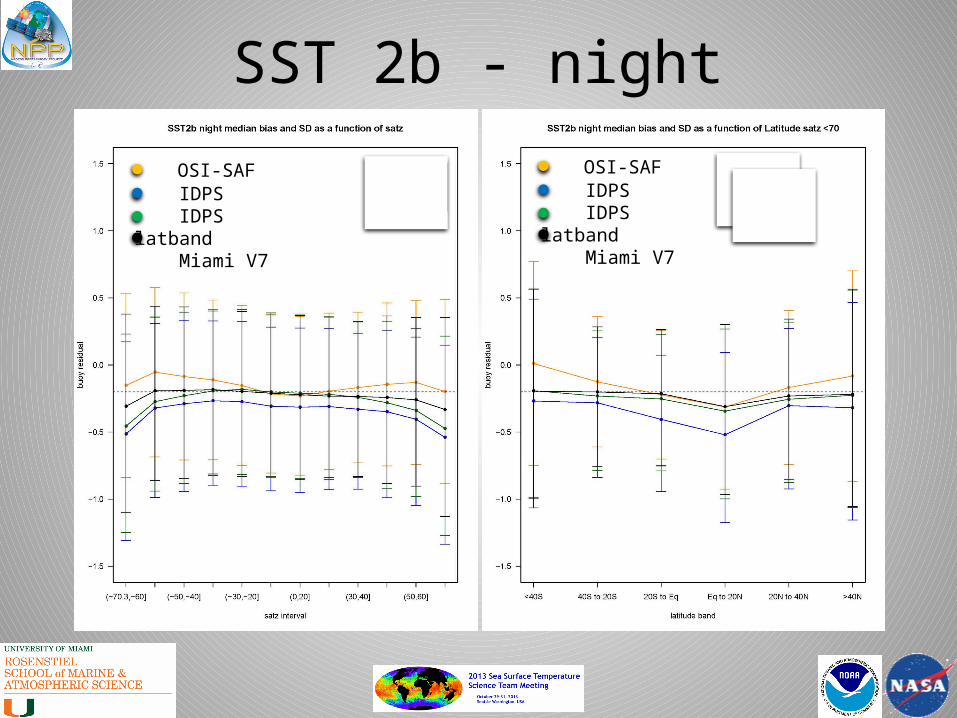
SST 2b - night
OSI-SAF IDPS IDPS latband Miami V7
OSI-SAF IDPS IDPS latband Miami V7
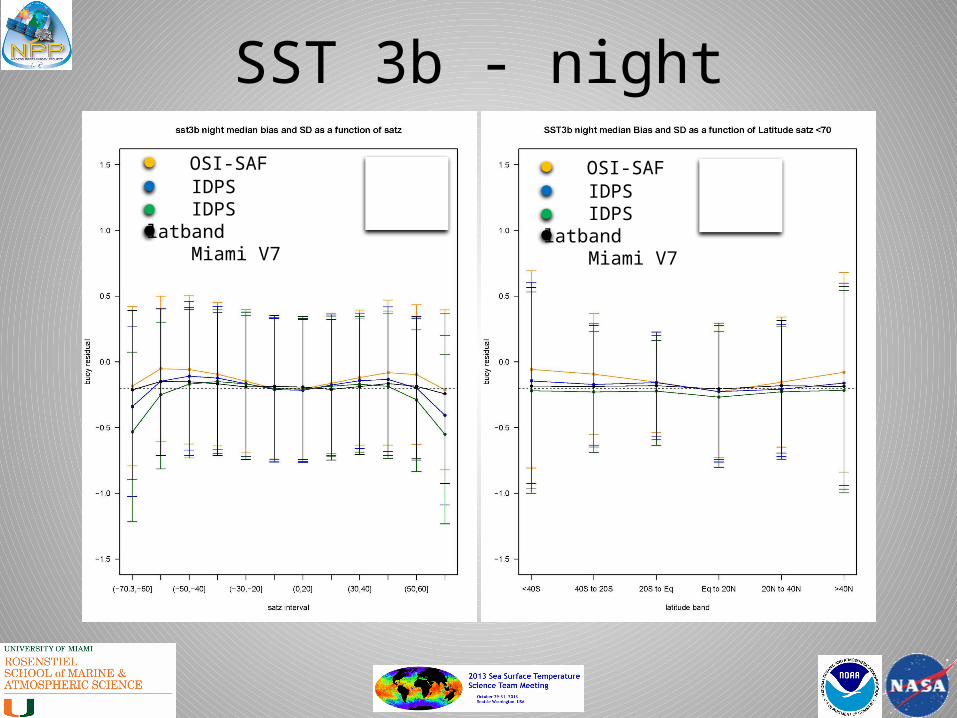
SST 3b - night
OSI-SAF IDPS IDPS latband Miami V7
OSI-SAF IDPS IDPS latband Miami V7
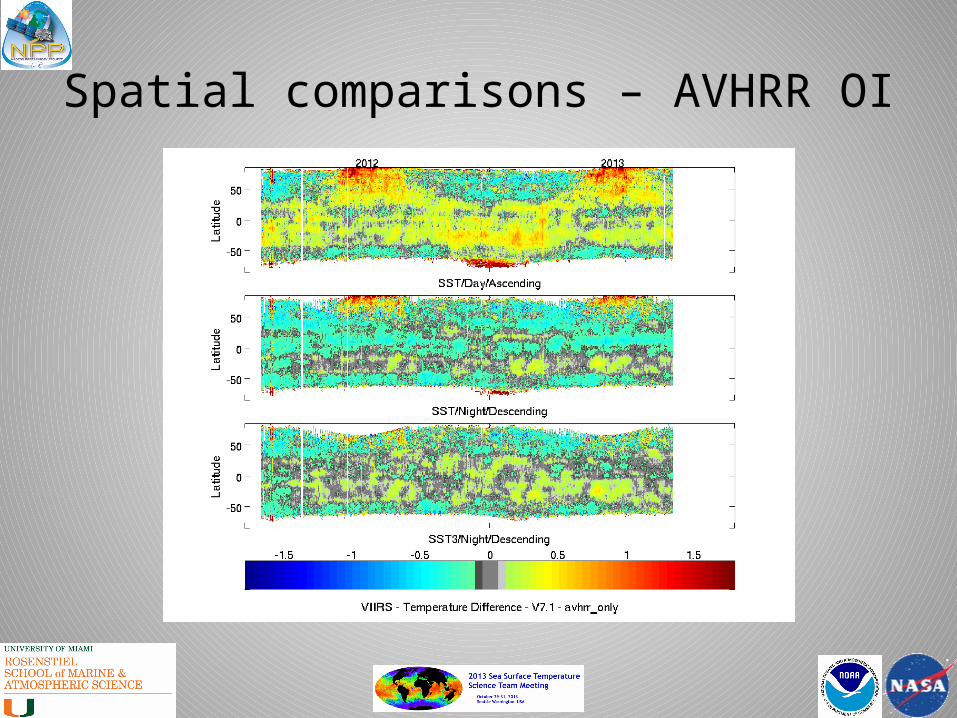
Spatial comparisons – AVHRR OI
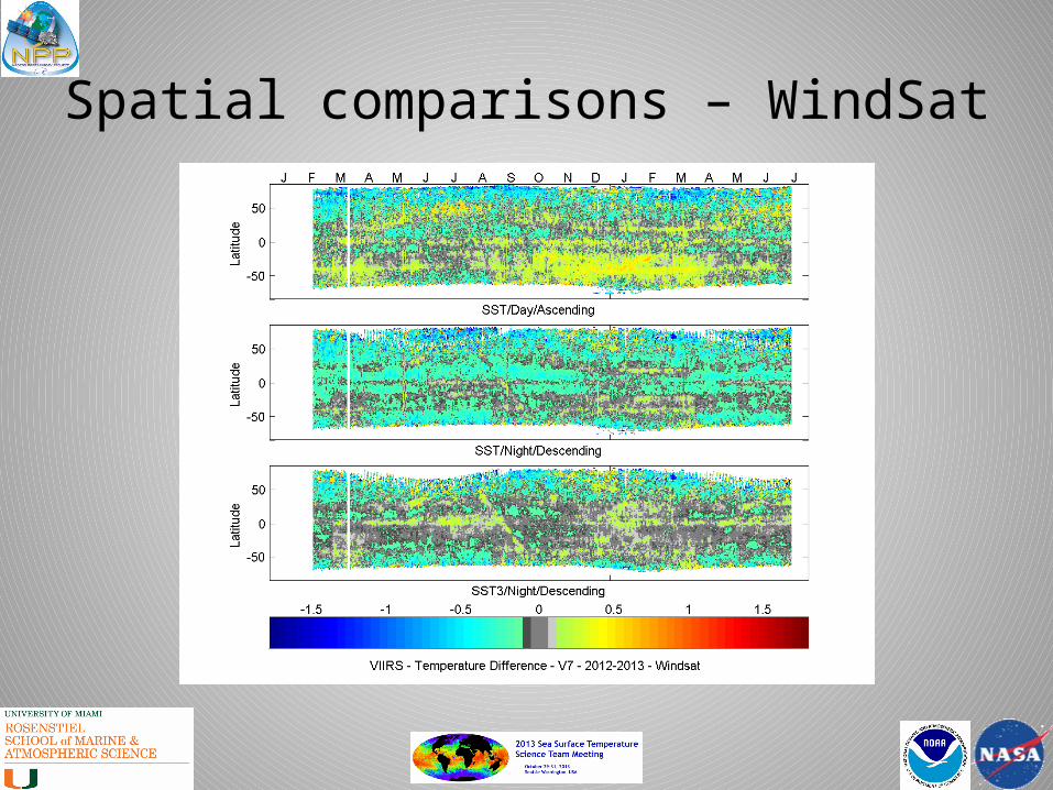
Spatial comparisons – WindSat
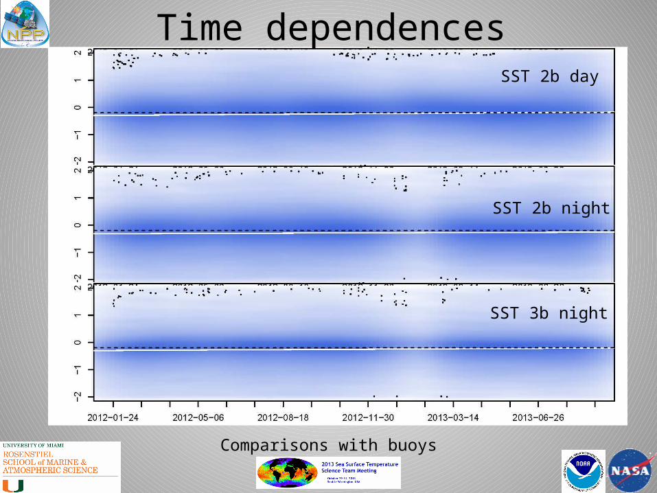
Time dependences
Comparisons with buoys
SST 2b day
SST 2b night
SST 3b night
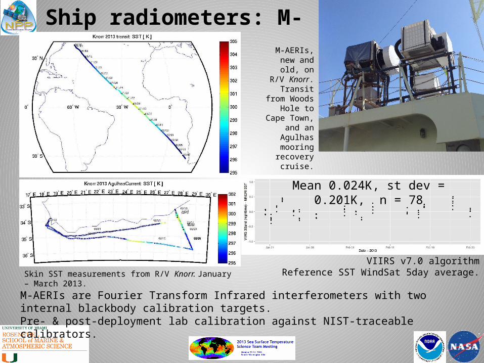
Ship radiometers: M-AERIs
M-AERIs are Fourier Transform Infrared interferometers with two internal blackbody calibration targets.Pre- & post-deployment lab calibration against NIST-traceable calibrators.
Skin SST measurements from R/V Knorr. January – March 2013.
M-AERIs, new and old, on R/V
Knorr. Transit from Woods
Hole to Cape Town, and an
Agulhas mooring
recovery cruise.
VIIRS v7.0 algorithmReference SST WindSat 5day average.
Mean 0.024K, st dev = 0.201K, n = 78

Ship radiometers: ISARs
ISARs are autonomous filter radiometers with two internal blackbody calibration targets.
Pre- & post-deployment lab calibration against NIST-traceable calibrators.
Data relayed in real-time by Iridium.
M/V Andromeda Leader
M/V Horizon SpiritMean -0.058 K, st dev = 0.417K, n = 337

Spatial distribution of errors
Comparisons with ship radiometers

Summary• VIIRS is a good SST radiometer, as good as, if not better
than MODIS.• Errors are fairly stable in time.• Spatial comparisons with WindSat microwave SSTs give
more uniform agreement than with infrared OI SSTs.• Full swath retrievals are improved by the use of
additional zenith angle terms.• Form of algorithms provides continuity with heritage
sensors.• Comparison with ship-board radiometers provides
mechanism for contributing the SST Climate Data Record.

Future directions• Continue to populate matchup data base, leading to error
hypercube.• Continue refinement of atmospheric correction
algorithm.• Compare with AMSR2 microwave SSTs.• Continue matchups with ship radiometers – provide
pathway to contributing to the SST CDR.• Work with NASA Goddard Ocean Color Processing
Group and with NASA JPL PO.DAAC to produce VIIRS SSTs in GHRSST L2P format for wider distribution to the community.
• Continue to work with NOAA STAR VIIRS Team.