st andrews harbour pontoon development · st andrews harbour pontoon development supporting...
TRANSCRIPT
St Andrews Harbour Pontoon Development
Supporting Environmental Planning Information-
Hydrology and Ecology

Supporting Hydrology & Ecology Information November 2014
2
SUPPORTING HYDROLOGY & ECOLOGY INFORMATION
Introduction
1. This statement has been prepared by EnviroCentre to provide information, in support of a planning application
for the development of pontoons within St Andrews Harbour. The scope of work has been undertaken in
response to comments provided in the Fife Council EIA Screening Opinion letter (Ref 13/014, 17th September
2014).
Site Description
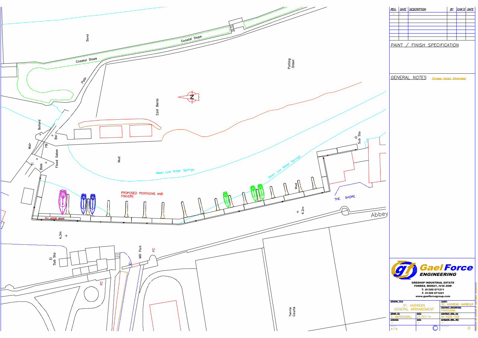
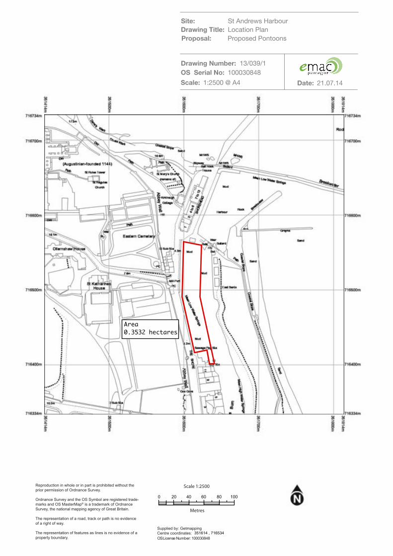
2. A location plan (drawing number13/039/1 dated 21/07/2014) showing the proposed planning application
boundary is enclosed. The site extends to an area of approximately 0.35 hectares and forms the western part
of the inner basin of St Andrews Harbour.
Project Understanding
3. It is our understanding that the proposals are to install 16 moorings with finger pontoons, at St Andrews
Harbour Western Quayside, to allow berthing for 33 vessel berths. This requires the construction of an access
bridge in the northern section of the development, which will be approximately 24 m long. The proposed
layout of the pontoons is shown on the enclosed plan (Drawing number M-3555-002, 21/07/2014).
4. We have been provided by indicative and generic engineering drawings, which show that the pontoons will be
fixed onto a vertical pile attached to the harbour wall and that only at low tide will they rest on the harbour
bed. We understand that there will be no piling into the bed sediment required.
5. According to the Screening opinion, the proposals are deemed not to require an Environmental Impact
Assessment (EIA), as per the terms of the Town & Country Planning (Scotland) EIA Regulations 2011, although
it would appear Marine Scotland (MS) are still to be consulted for their opinion on this. The Screening Opinion
notes concerns of both the Council and SEPA with regards to potential impacts on ecology and hydrology of
the harbour and requests an assessment to confirm that the proposed pontoon development will not result in
adverse effects.
Scope of Works
6. The following scope of works was undertaken:
Ecology
Desktop study of the site, to review ecological records and to establish the current baseline
conditions and identify if there are any ecological sensitivities that could be impacted by the proposed
development; and
A site walkover by two ecologists from EnviroCentre to assess the potential effects of the proposals
on protected species, such as otters, as well as wintering and nesting birds.
Supporting Hydrology & Ecology Information November 2014
3
Hydrology
Desktop hydrological study-to review published data including Ordnance Survey mapping, aerial
photography and bathymetric data (if available); and
Preparation of concise statement on hydrology confirming low or negligible impact on the water
environment and stating any mitigation or control measures required.
7. The following sections detail the results of the hydrological and ecological investigations.
Ecology
Desk Study
8. In order to anticipate the potential ecological sensitivities at the site and to establish the current baseline
conditions, a desk study was conducted in advance of the survey, as follows:
Existing data on protected sites available through Scottish Natural Heritage (SNH) Sitelink website1(up
to 5 km from the site);
Fife Local Development Plan (LDP)2 (for non-statutory designated sites);
Records of Ancient Woodlands available through Sketchmap3;
Records from Fife Nature Records Centre (FNRC);
Fife Biodiversity Action Plan (LBAP)4; and
UK Biodiversity Action Plan5.
9. The results of the desk study are presented in Table 1 below.
1 SNH Sitelink website. Available at http://gateway.snh.gov.uk/sitelink/searchmap.jsp 2 Fife Local Development Plan. Available at: http://www.fifedirect.org.uk/topics/index.cfm?fuseaction=page.display&p2sid=C1B5A275-1CC4-E06A-5244E84FE17EFBCE&themeid=2B482E89-1CC4-E06A-52FBA69F838F4D24Accessed on: 28/10/14. 3 Sketchmap using Ancient Woodland layer. Available at http://sketchmap.co.uk/ 4 Fife Biodiversity Action Plan (LBAP) (2013-2018). Available at: https://www.st-andrews.ac.uk/media/estates/documents/Fife%20Local%20Biodiversity%20Action%20Plan.pdf Accessed on 28/10/14. 5 UK Biodiversity Action Plan. Available at: http://jncc.defra.gov.uk/page-5155
Supporting Hydrology & Ecology Information November 2014
4
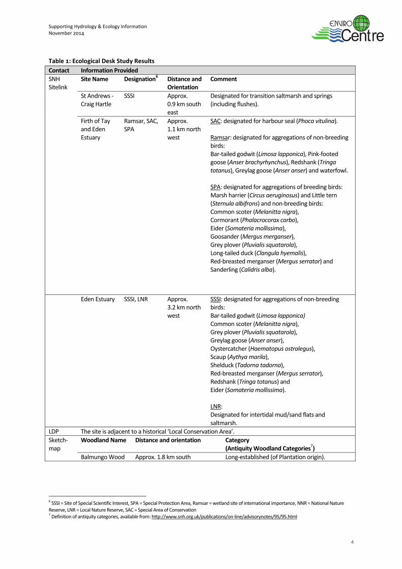
Table 1: Ecological Desk Study Results
Contact Information Provided
SNH Sitelink
Site Name Designation6 Distance and
Orientation Comment
St Andrews -Craig Hartle
SSSI Approx. 0.9 km south east
Designated for transition saltmarsh and springs (including flushes).
Firth of Tay and Eden Estuary
Ramsar, SAC, SPA
Approx. 1.1 km north west
SAC: designated for harbour seal (Phoca vitulina). Ramsar: designated for aggregations of non-breeding birds: Bar-tailed godwit (Limosa lapponica), Pink-footed goose (Anser brachyrhynchus), Redshank (Tringa totanus), Greylag goose (Anser anser) and waterfowl. SPA: designated for aggregations of breeding birds: Marsh harrier (Circus aeruginosus) and Little tern (Sternula albifrons) and non-breeding birds: Common scoter (Melanitta nigra), Cormorant (Phalacrocorax carbo), Eider (Somateria mollissima), Goosander (Mergus merganser), Grey plover (Pluvialis squatarola), Long-tailed duck (Clangula hyemalis), Red-breasted merganser (Mergus serrator) and Sanderling (Calidris alba).
Eden Estuary SSSI, LNR Approx. 3.2 km north west
SSSI: designated for aggregations of non-breeding birds: Bar-tailed godwit (Limosa lapponica) Common scoter (Melanitta nigra), Grey plover (Pluvialis squatarola), Greylag goose (Anser anser), Oystercatcher (Haematopus ostralegus), Scaup (Aythya marila), Shelduck (Tadorna tadorna), Red-breasted merganser (Mergus serrator), Redshank (Tringa totanus) and Eider (Somateria mollissima). LNR: Designated for intertidal mud/sand flats and saltmarsh.
LDP The site is adjacent to a historical ‘Local Conservation Area’.
Sketch-map
Woodland Name Distance and orientation Category (Antiquity Woodland Categories
7)
Balmungo Wood Approx. 1.8 km south Long-established (of Plantation origin).
6 SSSI = Site of Special Scientific Interest, SPA = Special Protection Area, Ramsar = wetland site of international importance, NNR = National Nature Reserve, LNR = Local Nature Reserve, SAC = Special Area of Conservation 7 Definition of antiquity categories, available from: http://www.snh.org.uk/publications/on-line/advisorynotes/95/95.html
Supporting Hydrology & Ecology Information November 2014
5
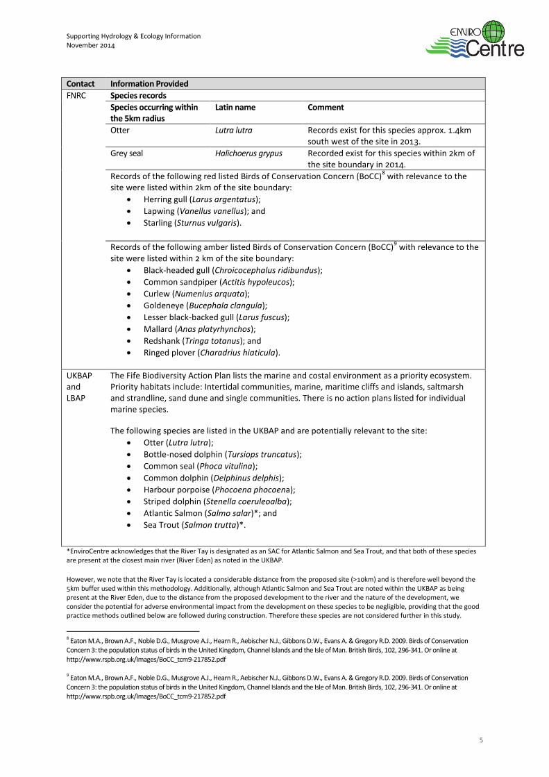
Contact Information Provided
FNRC Species records
Species occurring within the 5km radius
Latin name Comment
Otter Lutra lutra Records exist for this species approx. 1.4km south west of the site in 2013.
Grey seal Halichoerus grypus
Recorded exist for this species within 2km of the site boundary in 2014.
Records of the following red listed Birds of Conservation Concern (BoCC)8 with relevance to the
site were listed within 2km of the site boundary:
Herring gull (Larus argentatus);
Lapwing (Vanellus vanellus); and
Starling (Sturnus vulgaris).
Records of the following amber listed Birds of Conservation Concern (BoCC)9 with relevance to the
site were listed within 2 km of the site boundary:
Black-headed gull (Chroicocephalus ridibundus);
Common sandpiper (Actitis hypoleucos);
Curlew (Numenius arquata);
Goldeneye (Bucephala clangula);
Lesser black-backed gull (Larus fuscus);
Mallard (Anas platyrhynchos);
Redshank (Tringa totanus); and
Ringed plover (Charadrius hiaticula).
UKBAP and LBAP
The Fife Biodiversity Action Plan lists the marine and costal environment as a priority ecosystem. Priority habitats include: Intertidal communities, marine, maritime cliffs and islands, saltmarsh and strandline, sand dune and single communities. There is no action plans listed for individual marine species.
The following species are listed in the UKBAP and are potentially relevant to the site:
Otter (Lutra lutra);
Bottle-nosed dolphin (Tursiops truncatus);
Common seal (Phoca vitulina);
Common dolphin (Delphinus delphis);
Harbour porpoise (Phocoena phocoena);
Striped dolphin (Stenella coeruleoalba);
Atlantic Salmon (Salmo salar)*; and
Sea Trout (Salmon trutta)*.
*EnviroCentre acknowledges that the River Tay is designated as an SAC for Atlantic Salmon and Sea Trout, and that both of these species are present at the closest main river (River Eden) as noted in the UKBAP.
However, we note that the River Tay is located a considerable distance from the proposed site (>10km) and is therefore well beyond the 5km buffer used within this methodology. Additionally, although Atlantic Salmon and Sea Trout are noted within the UKBAP as being present at the River Eden, due to the distance from the proposed development to the river and the nature of the development, we consider the potential for adverse environmental impact from the development on these species to be negligible, providing that the good practice methods outlined below are followed during construction. Therefore these species are not considered further in this study.
8 Eaton M.A., Brown A.F., Noble D.G., Musgrove A.J., Hearn R., Aebischer N.J., Gibbons D.W., Evans A. & Gregory R.D. 2009. Birds of Conservation Concern 3: the population status of birds in the United Kingdom, Channel Islands and the Isle of Man. British Birds, 102, 296-341. Or online at
http://www.rspb.org.uk/Images/BoCC_tcm9-217852.pdf 9 Eaton M.A., Brown A.F., Noble D.G., Musgrove A.J., Hearn R., Aebischer N.J., Gibbons D.W., Evans A. & Gregory R.D. 2009. Birds of Conservation
Concern 3: the population status of birds in the United Kingdom, Channel Islands and the Isle of Man. British Birds, 102, 296-341. Or online at http://www.rspb.org.uk/Images/BoCC_tcm9-217852.pdf
Supporting Hydrology & Ecology Information November 2014
6
Site Visit
10. Two EnviroCentre ecologists completed an ecological walkover survey on 5th October 2014, when conditions
were sunny with a light breeze and 10% cloud cover. The air temperature was 15°C. A buffer zone of a 50 m
radius around the site was surveyed for protected species. The otter survey boundary extended along the
banks of St Andrews Harbour and 200 m up- and downstream from the site, where access allowed.
11. It was not possible to access the survey buffer for otter south of Abbey Walk (A917) due to the presence of
highly vegetated, steep banks.
Assessment of Potential Impacts
Methods
12. The otter survey followed best practice guidelines10
. A search was made for suitable habitat along with field
signs, including:
Spraints (otter faeces/droppings used as territorial signposts. Often located in prominent positions
and can be placed on deliberate piles of soil or sand);
Footprints;
Feeding remains (can often be a useful indication of otter presence);
Paths/slides (otter can often leave a distinctive path from and into the watercourse);
Holts: holts (underground shelters) are generally found:
o Within trees roots at the edge of the bank of a river;
o Within hollowed out trees; and
o In naturally formed holes in the river banks that can be easily extended;
Or preferably in ready-made holes created by other large mammals or humans such as badgers sett,
rabbit burrows or outlet pipes; and
Couches/lay-ups (couches or lay-ups are places for lying up above ground are usually located near a
watercourse, between rocks or boulders, under dense vegetation).
13. Wintering, nesting birds’ and marine mammals were also noted if recorded within the site boundary and
survey buffer.
Results
Otter
14. No evidence of otter was recorded during the survey.
15. The western bank within the site boundary consists of a harbour wall comprised of vertical stone to a height of
approximately 10 m. This habitat is unsuitable for otter holt creation due to the lack of mature tree root
cavities or naturally formed holes in the bank. The eastern bank was formed largely of mud flats also
unsuitable for otter holt creation. The habitat within the site boundary is highly disturbed by the presence of
fishing and boating activities, as well as local pedestrians and dog walkers, further reducing the suitability of
the site for otter. To the north of the site, within the survey buffer, large boulders covered in seaweed are
present which may offer some limited potential for sheltering and foraging otter. The habitat directly south of
the site was also unsuitable for sheltering, foraging and commuting otter, due to the exposed and disturbed
nature of the habitat. Due to survey constraints, it was not possible to fully access the 200m survey buffer
10 Chanin, P (2003). Natura Life Series, Monitoring the European Otter. Natural England.
Supporting Hydrology & Ecology Information November 2014
7
south of the site. The desk study returned records of otter along this watercourse, 1.4km south west of the
site, however the development is not anticipated to have an impact, given the distance from the development,
to where otters may be active.
Birds
16. Several bird species were noted in low numbers foraging on the mudflats, across the channel to the east of the
proposed development. This included redshank (Tringa totanus), grey heron (Ardea cinerea), grey wagtail
(Motacilla cinerea), curlew (Numenius arquata) and cormorant (Phalacrocorax carbo).
17. Although several of the species are either afforded extra legal protection or are listed as Red or Amber Birds of
Conservation Concern, none of the sightings constitutes unusual or unexpected records locally, with many of
the species being common and widespread breeding birds in northern Britain. Much of the nationwide fall in
breeding numbers for these species is not mirrored in Scotland, where ideal habitat and weather conditions
persist.
Marine mammals
18. No evidence of marine mammals was noted during the site walkover. The desk study highlighted that several
species of marine mammal are present in the wider area and are listed in the Fife LBAP. The Firth of Tay and
Eden Estuary is also designated as a Special Area of Conservation (SAC) for harbour seal.
19. The methods of engineering to be used in construction of the pontoons will generate noise as the piles are
attached to the quayside walls. As we understand it, this will result only in airborne noise and not a direct
underwater noise which could impact on marine mammals in the locality. For this reason, we do not believe
the proposed works will have an adverse effect on marine mammals.
Conclusion
20. The survey area does not support any sites designated for nature conservation at a local or national level and
no evidence of protected species was identified within the site or survey buffer. Providing the mitigation
measures detailed below are followed, it is not anticipated that there will be a residual impact on protected
species. If works at the site do not begin before October 2015, it is recommended that the protected species
survey is updated.
Proposed Mitigation
21. Any trenches or pits should be covered when unattended or a shallow angled plank inserted to allow animals
to escape, should they become trapped inside them. The ends of any pipeline should be capped when
unattended, or at the end of each working day to prevent animal access.
22. In the event that a protected species is discovered on site all work in that area must stop immediately and an
ecologist contacted. Details of the local police Wildlife Crime Officer, SNH Area Officer and Scottish Society for
the Prevention of Cruelty to Animals (SSPCA) relevant Officer could be held in site emergency procedure
documents.
23. Mammal foraging and commuting routes can be disturbed by inappropriate lighting. It is recommended that
night time lighting required at the site, both during construction and post construction, be kept to a minimum
and its use avoided where possible. If lighting is required, appropriate shades should be fitted that will prevent
light spillage onto the trees of other linear features that could be used by bats to commute and forage. It is
advised that low pressure sodium lamps are used instead of mercury or metal halide.
Supporting Hydrology & Ecology Information November 2014
8
Residual Impacts
24. Protected species survey data is valid for 12 months. Providing that ground works commence before October
2015, no further survey work in relation to otter or birds is considered necessary. If the site boundary was to
change, further survey work may be required.
25. After the application of mitigation measures it is not anticipated that there will be any residual impacts from
the proposed development.
Hydrology
Hydrological Context
26. The proposed pontoons are located within the inner harbour of St. Andrews. The harbour is situated at the
mouth of the Kinness Burn at St. Andrews Bay. The Kinness Burn is a small watercourse with a catchment area
of approximately 30 km2.
11
27. Vertical quay walls have been constructed along most of the shore lengths in the harbour except for the
southern half of the eastern shore. All quay walls are in frequent use as berths for small pleasure craft and
boats regularly moor up two boats side by side. Some mooring buoys are also available in the centre of the
harbour.
28. Water levels in the harbour are tidal with an estimated spring tidal range of just over 4 m based on data at the
River Tay bar12
. The harbour dries out during low tides completely except for a narrow meandering channel of
the Kinness Burn. The 1/1,000 year tidal flood level in St. Andrews Bay is approximately 4.0 mAOD 13
which is
just below the road level (The Shore) of between 4.2 and 4.3 mAOD. Quay walls levels are slightly below the
road levels and may therefore be at risk of flooding during extreme storm surges.
29. Hydraulic and morphological processes within the harbour are influenced by a set of lock gates and concrete
sill at the harbour entrance. The lock gates are configured to be closed during low tide (i.e. to keep water in
the harbour). The total width between the headwalls is approximately 7 m and the sill level is located just
above the lowest astronomical tide (LAT). The effect of the sill, narrow harbour entrance and quay walls is that
the bed material is much less mobile compared with a natural river mouth. Sediment may get trapped
upstream of the sill and the planform alignment of the river channel is constrained by the quay walls.
30. The lock gates are normally kept in an open position. Their main purpose is to enable flushing of sediment
from the harbour although they also provide some protection during storms14
. This is achieved by closing the
gates at during the ebb tide and opening these at low water. These operations are scheduled approximately
during one week every month15
.
11 CEH (2009). FEH CD-ROM 3. Wallingford: Centre for Ecology & Hydrology. 12 UKHO (n.d.). Admiralty EasyTide. Taunton: The United Kingdom Hydrographic Office. Retrieved from http://www.ukho.gov.uk/Easytide/ 13 McMillan, A., Batstone, C., Worth, D., Tawn, J., Horsburgh, K. & Lawless, M. (2011). Coastal flood boundary conditions for UK mainland and islands; Project: SC060064/TR2: Design sea levels. Bristol: Environment Agency. 14 SAHT (n.d.-a). History of the Development of St Andrews Harbour. St Andrews: St Andrews Harbour Trust. 15 SAHT (n.d.-b). Planned Harbour Operations. St Andrews: St Andrews Harbour Trust. Retrieved from http://standrewsharbourtrust.org/harbourops.html
Supporting Hydrology & Ecology Information November 2014
9
Appraisal of Potential Effects
31. Fife Council stated that “in terms of the hydrology the proposed pontoons would not extend into the
Kinnessburn water flow channel and would not affect the tidal range in any way. The pontoons would be
designed to sit on the harbour bed and float with the tide. The effect on currents would be no more than that
of tethered boats.” (Screening opinion, Ref 13/014, 17 September 2014).
32. The proposed installation and use of pontoons along the western quay wall are not expected to have a
detrimental effect on the water environment including tidal and fluvial hydraulics and sediment processes.
33. Mooring of boats currently takes place along the quay and while under the proposed conditions moored boats
may extend slightly further into the harbour due to the perpendicular mooring along finger berths, this is not
expected to influence the tidal or river currents due to the small size and draught of the pleasure craft.
34. During low tide, boats will dry out on the river bed along the foot of the quay. On a very small scale this may
affect erosion of deposition of sediment but this will be no greater than under existing conditions.
These effects should be considered within the context of a heavily engineered and
managed marine environment.
35 Overall, the development is considered not to have a detrimental effect on the water environment.
Construction Water Environment Management
36. Construction works in and near the water environment are regulated activities and may require authorisation
under The Water Environment (Controlled Activities) (Scotland) Regulations 2011 (as amended) (CAR).
Guidance published by SEPA16
is not conclusive in what level of authorisation is required for the installation of
pontoons and consultation with SEPA will therefore be undertaken to confirm this. At this stage, it’s envisaged
that no authorisation is required due to the low-impact of the development and that any works would be
subject to relevant General Binding Rules (GBR) under the CAR.
37. All construction works will be undertaken in line with current best practice in relation to construction in or
near the water environment. Relevant Pollution Prevention Guidelines (PPGs) including “PPG5: Works and
maintenance in or near water” will be implemented by the contractor to prevent any contaminants entering
the harbour, for example during plant operations, concrete pouring (if required) etc.
16 SEPA (2013). The Water Environment (Controlled Activities) (Scotland) Regulations 2011 (as amended); A practical guide. Stirling: Scottish Environment Protection Agency.

Supporting Hydrology & Ecology Information November 2014
10
Conclusions
38. The results of the ecological and hydrological studies indicate that, with appropriate mitigation measures in
place, there should be no detrimental effects on the water or ecology environment relating to the proposed
pontoon development, providing that works are undertaken in line with best practice guidance in mind.

Drawings November 2014
11
DRAWINGS
Reproduction in whole or in part is prohibited without the
prior permission of Ordnance Survey.
Ordnance Survey and the OS Symbol are registered trade-
marks and OS MasterMap® is a trademark of Ordnance
Survey, the national mapping agency of Great Britain.
The representation of a road, track or path is no evidence
of a right of way.
The representation of features as lines is no evidence of a
property boundary.
Supplied by: Getmapping
Centre coordinates:
0 20 40 60 80 100
Scale 1:2500
Metres
OS License Number: 100030848
351614 , 716534
Site: St Andrews Harbour!
Proposal: Proposed Pontoons!
Drawing Title: Location Plan
Drawing Number: 13/039/1
Scale: 1:2500 @ A4 Date: 21.07.14
OS Serial No: 100030848
Area!
0.3532 hectares