staff report 1-6-16 - santa barbara...
TRANSCRIPT
SANTA BARBARA COUNTY PLANNING COMMISSION
Staff Report for Phillips 66 Cal-Coast Pipeline Replacement Project
Hearing Date: January 27, 2016 Deputy Director: Kevin Drude
Staff Report Date: January 6, 2016 Division: Energy & Minerals
Case No.: 15DVP-00000-00004 Staff Contact: Kathy Pfeifer
Environmental Document: Notice of Exemption Planner Phone #: 568-2507
per CEQA Statute Section 21080.23 Supervising Planner: Errin Briggs
Supervising Planner Phone #: 568-2047
OWNER/APPLICANT Alfred Butch Lemos
Phillips 66 Pipeline LLC
1580 East Battles Road
Santa Maria, CA 93454
(805) 925-5795
AGENT & ENGINEER
Brien Vierra
FJ Technologies, Inc.
P.O. Box 926
Atascadero, CA 93423
(805) 235-7943
Application Complete:
August 5, 2015
1.0 REQUEST
Hearing on the request of Brien Vierra, agent for Phillips 66 Pipeline, LLC (Phillips 66), to
consider Case No. 15DVP-00000-00004, [application filed on April 6, 2015], for approval of a
Development Plan in compliance with Section 35.82.080 of the County Land Use and
Development Code, on property zoned AG-II-100, to construct and operate a 1.2-mile long, 6-inch
diameter, buried crude oil pipeline within an existing pipeline corridor; and to determine the project
is exempt from the provisions of the California Environmental Quality Act (CEQA) pursuant to
State CEQA Guidelines Section 21080.23.
The application involves Assessor Parcel Number (APN) 101-020-080, located at 7476 Graciosa
Road, in the Santa Maria Valley area, Fourth Supervisorial District.
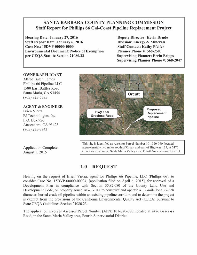
This site is identified as Assessor Parcel Number 101-020-080, located
approximately two miles south of Orcutt and east of Highway 135, at 7476
Graciosa Road in the Santa Maria Valley area, Fourth Supervisorial District.
�
Orcutt
Hwy 135/
Graciosa Road
Proposed
Replacement
Pipeline

Phillips 66 Cal-Coast Pipeline Replacement Project/15DVP-00000-00004
Hearing Date: January 27, 2016
Page 2
2.0 RECOMMENDATION AND PROCEDURES
Follow the procedures outlined below and conditionally approve Case No. 15DVP-00000-00004
marked "Officially Accepted, County of Santa Barbara (January 27, 2016) County Planning
Commission Attachments A-D", based upon the project's consistency with the Comprehensive
Plan and based on the ability to make the required findings.
Your Commission's motion should include the following:
1. Make the required findings for approval of the project, including the CEQA findings,
specified in Attachment A of this staff report.
2. Determine the project is exempt from CEQA pursuant to State CEQA Guideline Section
21080.23 of CEQA, specified in Attachment C of this staff report.
3. Approve the project (15DVP-00000-00004) subject to the Conditions of Approval,
specified in Attachment B of this staff report.
Refer back to staff if the Commission takes other than the recommended action for appropriate
findings and conditions.
3.0 JURISDICTION
The Review Authority table in Section 35.82.080.B.3 of the County Land Use and Development
Code (LUDC) identifies that Development Plans which are outside of the review authority of the
Planning Director and Zoning Administrator are under the authority of the Planning Commission.
Therefore, the Planning Commission is the decision maker for the proposed Development Plan.
4.0 ISSUE SUMMARY
The proposed new pipeline would be an in-kind replacement of an existing pipeline, and the new
pipeline would be located in the same corridor as the existing pipeline. Because the project is a
replacement in-kind, it is Statutorily exempt from the California Environmental Quality Act
(CEQA), pursuant to Section 21080.23 (see Attachment C of this staff report). In order to
preemptively reduce project impacts to the maximum extent feasible, the applicant has included
specific avoidance and reduction measures in the project description. Additionally, staff has
recommended conditions to ensure the project complies with County policies that protect natural
resources (see Sections 6.2 and 6.3 and Attachment B of this staff report).
The new pipeline would replace an existing pipeline that is approximately 70 years old, thereby
reducing operational risks associated with transporting crude oil. The new pipeline would be
equipped with an automatic shutdown system that triggers the automatic shutdown and isolates
the line, if necessary, when operating parameters (flow and pressure) deviate from the normal
operating range. The new pipeline would be equipped with motor operated isolation valves at
the start and end of the pipeline as well as a check valve at the end of the pipeline to prevent a
Phillips 66 Cal-Coast Pipeline Replacement Project/15DVP-00000-00004
Hearing Date: January 27, 2016
Page 3
backflow. The isolation valves would allow for pipeline shutdown in case of an emergency,
isolation of leaks, and use of smart pigs to clean and maintain the entire length of the line. In
case of an upset, the shipping pumps would be shut down automatically, shutting down and
removing the source of crude into the pipeline. In addition, the applicant’s control center would
actively monitor the operating conditions of the line. The control center would receive alarms if
the operating parameters would go outside the normal operating range. The control center would
monitor the pipeline 24 hours a day.
Under oversight by the State Fire Marshall, the pipeline, valves, and fittings would be tested per
Federal and State Regulations before they are put into service as well as maintained per Federal
and State regulations while they are in service. The applicant would implement the following
measures to ensure the safe condition and operations of the pipeline: Cathodic protection to
prevent corrosion; smart-pigging of the line to determine line integrity; a Supervisory Control
and Data Acquisition (SCADA) system to actively monitor pipeline conditions; pigging
operations to clear pipeline debris and detect for anomalies; and installation of a corrosion probe
to monitor potential internal corrosion of the system.
The existing pipeline would be purged, cleaned and abandoned in place. Exposed portions of the
existing pipeline would be cut, capped and removed. Leaving the buried portions of the existing
pipeline in place minimizes project impacts to an onsite drainage and oak woodland, which could
result from its removal.
5.0 PROJECT INFORMATION
5.1 Site Information
Site Information
Comprehensive Plan Designation Inland, Rural, A-II-100, 100-acre minimum parcel size
Ordinance, Zone Land Use and Development Code (LUDC), AG-II-100, 100-acres
minimum lot size
Site Size 644.0-acres
Present Use & Development Cattle grazing, oil and gas development (pipeline)
Surrounding Uses/Zone(s) North: AG-II-100, open space, cattle grazing
South: AG-II-100, one residence, agriculture (vineyards), oil and
gas development, cattle grazing
East: AG-II-100, oil and gas development, open space,
agriculture (vineyards), cattle grazing
West: AG-II-100, Graciosa Road, State Highway 1, State
Highway 135, oil and gas development
Access State Highways 1 and 135 and Graciosa Road
Other Site Information Within Orcutt State-Designated Oil Field
Williamson Act Contract 14-AP-005
Public Services Water Supply: None
Sewage: None
Fire: County Fire Protection
Police Services: County Sheriff

Phillips 66 Cal-Coast Pipeline Replacement Project/15DVP-00000-00004
Hearing Date: January 27, 2016
Page 4
5.2 Setting
The existing pipeline corridor is located in the Santa Maria Valley area approximately two miles
south of the town of Orcutt in a rural area characterized by gently sloping grasslands used for
cattle grazing, agricultural production, and oil and gas development. The existing pipeline
corridor runs in a northeast to southwest direction. Elevation increases gradually from
approximately 450 feet above sea level at the southwest end to 700 feet at the northeast end of
the corridor. Soils within the site are sandy and classified as non-prime.
A drainage/creek travels northeast to southwest mostly parallel to the existing pipeline corridor.
The existing pipeline enters the drainage in two different locations for several hundred feet. The
exposed line is supported by stanchions that have been placed within the drainage; erosion occurs in
the drainage at some of the stanchion and pipeline locations.
Vegetation along approximately 75% of the pipeline corridor is relatively sparse and consists of
non-native annual grassland that is grazed by cattle. In the northeast corner of the pipeline corridor,
Coast Live Oaks (Quercus agrifolia), and willow (Salix) trees are located near the drainage
crossings.
Special-status wildlife species that could potentially occur in the project corridor or its vicinity
(300-ft buffer) include: Coast horned lizard (Phrynosoma blainvillii), Western spadefoot toad (Spea
hammondii), and American badger (Taxidea taxus); suitable habitat for these species is located
within the pipeline corridor and its vicinity.
At the northeastern end of the pipeline corridor is an existing oil and gas facility, operated by the
Pacific Coast Energy Company (PCEC). This facility contains above-ground equipment used for
processing oil and gas, including storage tanks, separators, and a Lease Automatic Custody
Transfer (LACT) unit. The LACT unit feeds crude oil into the existing pipeline for transport to
market. Six Coast live oak trees are growing adjacent to the LACT unit just outside of the facility
footprint.
An existing dirt road leads from the oil and gas facility to Graciosa Road, paralleling the pipeline
corridor. At the southwest end of the pipeline corridor, an existing pipeline valve box is located
next to Graciosa Road.
5.3 Description
The request is for a Development Plan (Case No. 15DVP-00000-00004) to allow for replacement
of a 1.2-mile crude oil pipeline located east of Graciosa Road and approximately two miles south of
Orcutt. Approximately half of the existing 6-inch diameter Cal-Coast pipeline lies within the State-
Designated Orcutt Oilfield, originating on the Pacific Coast Energy Company (PCEC)’s oil and gas
processing facility on the Cal-Coast Lease and transports the crude oil to the Phillips 66’s 8-inch
pipeline known as Line 353. Line 353 runs parallel to Graciosa Road and transports crude oil to the
Orcutt Pump Station in Orcutt (see page D-1 of Attachment D of this staff report).
Phillips 66 Cal-Coast Pipeline Replacement Project/15DVP-00000-00004
Hearing Date: January 27, 2016
Page 5
The proposed 1.2-mile, 6-inch diameter pipeline would replace the existing Cal-Coast pipeline, and
the new pipeline would be located within the existing pipeline corridor. However, instead of tying
into Line 353, as the existing Cal-Coast pipeline does, the proposed new pipeline would tie into
Phillips 66’s 12-inch diameter Line 300 (see page D-2 in Attachment D of this staff report). Line
300 and Line 353 pipelines are both located adjacent to Graciosa Road and run parallel to each
other in a northerly direction to the Orcutt Pump Station. Currently, the Line 300 system transports
crude oil production originating from offshore Platform Irene and the Lompoc area. The Line 353
system currently transports crude oil, originating from the Orcutt Oil Field collected by the
existing Cal-Coast pipeline. The Orcutt field is operated by the Pacific Coast Energy Company
(PCEC). The project would consolidate crude oil production from various sites into one primary
transportation system (Line 300). Line 353 would be left idled in place.
Specifically, the proposed project includes installation, operation, and maintenance of the following
structures:
• A new 1.2-mile, 6-inch diameter buried pipeline, located within the an existing pipeline
corridor, beginning at the Cal-Coast Lease and terminating at Line 300 near Graciosa Road.
• A flow metering skid with an approximate 20x40-foot footprint and a maximum height of
approximately eight (8) feet and a pig launcher facility with an approximate 20x30-foot
footprint and an approximate height of three (3) feet to be located within the footprint of
PCEC’s existing oil and gas facility on the Cal-Coast Lease.
• A pig receiver facility with an approximate 20x30-foot footprint and an approximate height of
three (3) feet with a below-grade pipeline tie-in to Line 300 to be installed adjacent to an
existing valve box for Line 300 near Graciosa Road.
Project activities would include surveying and staking the pipeline right-of-way (ROW), clearing
and grading the ROW, excavating a trench (18-inches wide x 4- to 5-feet deep), laying sections of
pipe in the trench, and backfilling the trench. The trench would be backfilled after each section of
pipe is laid in the trench. The trench would be excavated and backfilled in three increments, with no
more than a maximum of 2,000 feet open at one time. Following completion of installation
activities, the project site would be compacted and restored to its natural contours and areas of
disturbance would be re-vegetated. The pipeline would be directionally drilled, for a length of
approximately 1,400-feet, in the pipeline corridor where it crosses under a drainage and an oak
woodland. The directional drilling would be at an approximate depth of 12 to 15-feet below the
drainage flowline.
The new pipeline would replace an existing pipeline that is approximately 70 years old, thereby
reducing operational risks associated with transporting crude oil. The new pipeline would be
equipped with an automatic shutdown system that triggers the automatic shutdown and isolates
the line, if necessary, when operating parameters (flow and pressure) deviate from the normal
operating range. The new pipeline would be equipped with motor operated isolation valves at
the start and end of the pipeline as well as a check valve at the end of the pipeline to prevent a
backflow. The isolation valves would allow for pipeline shutdown in case of an emergency,
isolation of leaks, and use of smart pigs to clean and maintain the entire length of the line. In
case of an upset, the shipping pumps would be shut down automatically, shutting down and

Phillips 66 Cal-Coast Pipeline Replacement Project/15DVP-00000-00004
Hearing Date: January 27, 2016
Page 6
removing the source of crude into the pipeline. In addition, the applicant’s control center would
actively monitor the operating conditions of the line. The control center would receive alarms if
the operating parameters would go outside the normal operating range. The control center would
monitor the pipeline 24 hours a day.
Under oversight by the State Fire Marshall, the pipeline, valves, and fittings would be tested per
Federal and State Regulations before they are put into service as well as maintained per Federal
and State regulations while they are in service. The applicant would implement the following
measures to ensure the safe condition and operations of the pipeline: Cathodic protection to
prevent corrosion; smart-pigging of the line to determine line integrity; a Supervisory Control
and Data Acquisition (SCADA) system to actively monitor pipeline conditions; pigging
operations to clear pipeline debris and detect for anomalies; and installation of a corrosion probe
to monitor potential internal corrosion of the system.
Buried portions of the existing pipeline would be cleaned, purged, and abandoned in-situ. Exposed
portions of the pipeline and its support system (stanchions) in the drainage would be removed (cut
and capped).
Construction activities are estimated to last two to three months. Approximately 10 to 15 workers
would be onsite during project activities. The project would involve use of the following
equipment: Backhoe (2-3); trencher (1); excavator (2); sideboom (2); hydrocrane (1); dozer (1);
concrete/slurry trucks; tractor-trailer rigs; pickup trucks.
The project would cover a footprint of approximately four acres. Approximately 1,500 cubic yards
(CY) of both cut and fill and 100 CY of both import and export would be necessary to carry out the
project. Approximately 2.3 acres of vegetation would be disturbed or removed. All areas of
disturbance would be re-vegetated per the project’s County-approved Revegetation Plan, dated July
24, 2015.
Regional access to the project site would be provided by Highway 1/Highway 135 and Graciosa
Road and local access would be provided by existing interior agricultural and lease roads. The
project site would be gated to prevent public access during construction operations.
The project has a low potential of impacting California Tiger Salamander (CTS) (Ambystoma
californiense) and California Red-Legged Frog (CRLF) (Rana draytonii). Inclusion of the
following measures adds protection to reduce potential effects on wildlife, such as the California
Tiger Salamander (CTS) (Ambystoma californiense), California Red-Legged Frog (CRLF) (Rana
draytonii), Coast horned lizard (CHL) (Phrynosoma blainvillii), Western Spadefoot Toad (WST)
(Spea hammondii), and American Badger (Taxidea taxus):
• A pre-activity biological survey would be conducted within 30 days of the start of project
activities. All work areas and access routes to the work areas would be delineated with stakes
and flagging. These areas and a buffer would be re-surveyed by a qualified-biologist for sign of
sensitive species and/or habitat.
Phillips 66 Cal-Coast Pipeline Replacement Project/15DVP-00000-00004
Hearing Date: January 27, 2016
Page 7
• A qualified-biologist would present environmental awareness training to all onsite workers
prior to the start of the first day of work for the project. The presentation would include
information about the status of CTS, CRLF, WST, CHL, American Badger, and other special-
status species; their legal protections; reasons for their declines; identifying features of the
species; and what to do if one is observed. The presentation would be repeated as necessary for
new workers as they come onto the project site.
• Wildlife escape ramps would be set in open trenches prior to the end of each work day.
• Prior to the start of project activities, areas of excavation in which sediment could potentially be
transported off of the project site via storm water run-off would be enclosed with silt fencing or
similar fabric material. The fence would be buried six inches deep and extend at least 30 inches
above ground.
• A qualified-biologist would monitor all vegetation clearing during the project. The top 6-inches
of topsoil would be salvaged and segregated for replacement as topsoil upon project
completion.
• A qualified-biologist would monitor minor excavation of the bed and banks of the intermittent
drainage that the pipeline crosses to remove the existing line. The drainage would be avoided
by use of directional drilling a minimum of 12 feet under the drainage to install the new pipe. If
access to the drainage is necessary, only foot-traffic would be allowed.
• All work areas required for directional drilling would be located in non-sensitive upland areas.
• The construction corridor would be adjusted as much as possible to minimize or avoid potential
damage to oak trees.
• Staging, parking, and storage of project-related equipment and vehicles would be limited to
previously disturbed areas to the extent feasible.
• Site preparation and grading within drainage ditches would occur during the non-rainy season
of the year only (April 1 through November 31).
The property is comprised of 644 acres, zoned AG-II-100 and is located at 7476 Graciosa Road,
Santa Maria in the Fourth Supervisorial District. The project site is located on APN 101-020-080.
5.4 Background Information
The existing Cal-Coast pipeline was constructed as early as the 1940’s. Although the pipeline is
monitored by the control center, it currently is not protected by an automatic shut down system.
The pipeline has historically served as a line for several inland oil production sources. However,
the pipeline currently only transports crude oil produced from the Pinal, Diatomite, Newlove, and
Cal-Coast Leases, which are operated by the Pacific Coast Energy Company (PCEC). Crude oil
production is initially separated at PCEC’s existing oil and gas facilities on each lease before it
enters the Cal-Coast line, which then feeds into Line 353 for transport to the Orcutt Pump Station
and eventually to its final destination at the Santa Maria Refinery in San Luis Obispo County.
6.0 PROJECT ANALYSIS
6.1 Environmental Review
A Notice of Exemption was prepared for the proposed project under the requirements of the
Phillips 66 Cal-Coast Pipeline Replacement Project/15DVP-00000-00004
Hearing Date: January 27, 2016
Page 8
California Environmental Quality Act (CEQA) and is included herein as Attachment C. The
project can be found statutorily exempt from CEQA pursuant to State CEQA Section 21080.23,
which applies to projects which consist of the inspection, maintenance, repair, restoration,
reconditioning, relocation, replacement, or removal of an existing pipeline. The proposed new
pipeline would be an in-kind replacement of an existing 70-year old pipeline, and the new
pipeline would be located in the same corridor as the existing pipeline. Because the project is a
replacement in-kind, it is Statutorily exempt from the California Environmental Quality Act
(CEQA), pursuant to Section 21080.23 (see Attachment C of this staff report). In order to
preemptively reduce project impacts to the maximum extent feasible, the applicant has included
specific measures in the project description. Additionally, staff has recommended conditions for the
project to comply with County policies that protect natural resources (see Sections 6.2 and 6.3 and
Attachment B of this staff report).
6.2 Comprehensive Plan Consistency
REQUIREMENT DISCUSSION
Land Use Element Development Policy 4:
Prior to issuance of a development permit, the
County shall make the finding, based on
information provided by environmental
documents, staff analysis, and the applicant,
that adequate public or private services and
resources (i.e., water, sewer, roads, etc.) are
available to serve the proposed development.
Consistent: The proposed project would
include replacement of an existing, buried
crude oil pipeline and installation of associated
equipment (i.e. metering skid, pig
launcher/receiver facilities, tie-in point).
Vehicular access to the site would continue to
be provided by Highway 1/135 and Graciosa
Road and existing interior agricultural
roadways; no new roads would be required.
Project operations would not require water or
sewage. Water used during construction
activities (i.e. dust suppression) would be
brought in from the applicant’s Orcutt Pump
Station and water may be provided by PCEC’s
oil and gas facility onsite. The project would
be served by the County Fire Department and
the County Sheriff Department. There are
adequate private and public services and
resources available to serve the proposed
project. Based on the foregoing, the project is
consistent with this policy.
Land Use Element
Historical/Archaeological Sites Policy 2: When developments are proposed for parcels
where archaeological or other cultural sites are
located, project design shall be required which
avoids impacts to such cultural sites if
possible.
Consistent: There are no previously
documented archaeological sites that occur
within the project area, and no archaeological
or cultural resources were observed during the
Phase I survey performed by Archaeologist
Brent Leftwich, Ph.D., R.P.A. in May 2015.
The Phase I survey recommends that upon

Phillips 66 Cal-Coast Pipeline Replacement Project/15DVP-00000-00004
Hearing Date: January 27, 2016
Page 9
REQUIREMENT DISCUSSION
discovery of a potential resource, work in the
vicinity would be required to halt and would
not be able to resume until the find is evaluated
and treated according to the County’s
Archaeological Guidelines (Conditions 6 of
Attachment B). Based on the foregoing, the
project is consistent with this policy.
Land Use Element Visual Resource Policy 2:
In areas designated as rural on the land use
plan maps, the height, scale, and design of
structures shall be compatible with the
character of the surrounding natural
environment, except where technical
requirements dictate otherwise. Structures shall
be subordinate in appearance to natural
landforms; shall be designed to follow the
natural contours of the landscape; and shall be
sited so as not to intrude into the skyline as
seen from public viewing places.
Consistent: The proposed project would
include the following above ground structures:
an approximate 20x40-foot metering skid with
an approximate height of eight feet, an
approximate 20x30-foot pig launcher with an
approximate height of three feet, and a an
approximate 20x30 pig receiver with an
approximate height of three feet. The skid
meter and pig launcher would be located at an
existing oil and gas facility on the Cal Coast
Lease, which contains above-ground
equipment much larger in size. These
structures would not be viewable from public
viewing places. The pig receiver would be
located near Graciosa Road next to an existing
valve box. This structure’s height of three feet
would not intrude into the skyline from public
viewing places. The above ground piping
would be painted a tan/beige color to blend in
with the surrounding natural environment.
Based on the foregoing, the project is
consistent with this policy.
Land Use Element Hillside and Watershed
Protection Policy 1: Plans for development
shall minimize cut and fill operations. Plans
requiring excessive cutting and filling may be
denied if it is determined that the development
could be carried out with less alteration of the
natural terrain.
Consistent: The proposed new pipeline would
replace an existing crude oil pipeline. The new
pipeline would be 1.2 miles in length and
buried next to the existing line within the same
pipeline corridor. Grading activities for the
project would be limited to installation of the
new line and would include grading estimates
of approximately 1,500 cubic yards (CY) of cut
and fill and 100 CY of import and export. Use
of the existing pipeline corridor would avoid
construction of a new pipeline corridor and
environmental impacts associated with
development of previously undisturbed areas.
Phillips 66 Cal-Coast Pipeline Replacement Project/15DVP-00000-00004
Hearing Date: January 27, 2016
Page 10
REQUIREMENT DISCUSSION
Land Use Element Hillside and Watershed
Protection Policy 2:
Consistent: Grading activities for the project
would be limited to installation of the new line
and would include grading estimates of
approximately 1,500 cubic yards (CY) of both
cut and fill and 100 CY of both import and
export. Use of the existing pipeline corridor
would avoid construction of a new pipeline
corridor and environmental impacts associated
with development of previously undisturbed
areas. The existing pipeline would be cleaned,
purged, and abandoned in-situ, except for areas
of the line which are exposed. Exposed areas
would be removed. Leaving portions of the
existing buried pipeline in place reduces
impacts to the onsite drainage and oak
woodland.
To ensure protection of native vegetation and
trees, a qualified biologist would monitor
vegetation removal required for trenching of
the pipeline. All grading, trenching, ground
disturbance, construction activities and
structural development is required to occur
beyond six feet of the dripline for all oak trees
(see Condition 3 of Attachment B). Equipment
storage is required to be limited to previously
disturbed areas and located 100 feet from any
sensitive biological resources (see Condition 4
of Attachment B). Following pipeline
installation, the project site would be restored
to its natural contours and areas of disturbance
would be re-vegetated per the project’s
County-approved Revegetation Plan (see
Condition 5 of Attachment B).
The existing pipeline visibly crosses an
intermittent, unnamed drainage at two
locations. Vegetation near the drainage
crossings includes Coast Live Oak trees and
Willow trees. To avoid impacts to the drainage
and surrounding habitat, the new pipeline
would be directionally drilled at a depth of 12
to 15-feet below the drainage flowline. The
All developments shall be designed to fit the
site topography, soils, geology, hydrology, and
any other existing conditions and be oriented
so that grading and other site preparation is
kept to an absolute minimum. Natural
features, landforms, and native vegetation,
such as trees, shall be preserved to the
maximum extent feasible. Areas of the site
which are not suited to development because of
known soil, geologic, flood, erosion or other
hazards shall remain in open space.
Land Use Element Hillside and Watershed
Protection Policy 3: For necessary grading
operations on hillsides, the smallest practical
area of land shall be exposed at any one time
during development and the length of exposure
shall be kept to the shortest practicable amount
of time. The clearing of land should be avoided
during the winter rainy season and all measures
for removing sediments and stabilizing slopes
should be in place before the beginning of the
rainy season.
Land Use Element Hillside and Watershed
Protection Policy 5: Temporary vegetation,
seeding, mulching, or other suitable
stabilization method shall be used to protect
soils subject to erosion that have been
disturbed during grading or development. All
cut and fill slopes shall be stabilized as rapidly
as possible with planting of native grasses and
shrubs, appropriate non-native plants, or with
accepted landscaping practices.

Phillips 66 Cal-Coast Pipeline Replacement Project/15DVP-00000-00004
Hearing Date: January 27, 2016
Page 11
REQUIREMENT DISCUSSION
existing pipeline would be removed (cut and
capped) at the points where it is exposed over
the drainage, and the existing pipeline supports
would be removed from the drainage flowline.
A qualified-biologist would monitor the work
in the drainage. Project activities that would
occur within the drainage would be restricted
to the non-rainy season of the year only (See
Condition 1 of Attachment B).
The project description includes several
measures which would minimize disturbance
and alteration of surrounding areas, such as
reducing the size of work areas and adjusting
the construction corridor to avoid sensitive
areas. The trench would be excavated and
backfilled in three increments, with no more
than a maximum of 2,000 feet open at one time.
(See Condition 1 of Attachment B). Based on
the foregoing, the project is consistent with
these policies.
Land Use Element Hillside and Watershed
Policy 4: Sediment basins (including debris
basins, desilting basins, or silt traps) shall be
installed on the project site in conjunction with
the initial grading operations and maintained
through the development process to remove
sediment from runoff waters. All sediment
shall be retained on site unless removed to an
appropriate dumping location.
Land Use Element Hillside and Watershed
Protection Policy 6: Provisions shall be made
to conduct surface water to storm drains or
suitable watercourses to prevent erosion.
Drainage devices shall be designed to
accommodate increased runoff resulting from
modified soil and surface conditions as a result
of development. Water runoff shall be retained
onsite whenever possible to facilitate
groundwater recharge.
Land Use Element Hillside and Watershed
Consistent: The existing pipeline route
crosses over a drainage, where it is visibly
exposed at two locations. The proposed new
pipeline would be directionally drilled 12 to 15
feet below the drainage flowline to avoid
crossing the drainage. In addition, the applicant
includes measures to help reduce erosion and
sediment into the drainage by minimizing
alteration of the bed and banks of the drainage,
limiting the minor excavation work within the
drainages to the non-rainy season of the year,
and limiting storage and staging areas to
designated areas located away from the
drainage banks. These restrictions would
reduce the potential for sediment to be carried
into the drainages by storm water runoff (See
Condition 1 of Attachment B) both during
construction and project operation. Per the
Regional Water Quality Control Board’s
Certificate Number 34215WQ11, the applicant
would also employ several erosion sediment
control measures to prevent storm water

Phillips 66 Cal-Coast Pipeline Replacement Project/15DVP-00000-00004
Hearing Date: January 27, 2016
Page 12
REQUIREMENT DISCUSSION
Protection Policy 7: Degradation of the water
quality of groundwater basins, nearby streams,
or wetlands shall not result from development
of the site. Pollutants, such as chemicals, fuels,
lubricants, raw sewage, and other harmful
waste, shall not be discharged into or alongside
coastal streams or wetlands either during or
after construction.
Land Use Element Streams and Creeks
Policy 1: All permitted construction and
grading within stream corridors shall be carried
out in such a manner as to minimize impacts
from increased runoff, sedimentation,
biochemical degradation, or thermal pollution.
discharge during construction (see Condition
18 of Attachment B). Implementation of the
above measures would help ensure that
sediment and runoff water is retained onsite to
reduce potential impacts to water quality.
The applicant would also implement the
Horizontal Directional Drilling Management
Plan as approved by the County Planning and
Development Department, which describes
measures to implement in the event of a fluid
release during drilling operations (See
Condition 8 of Attachment B). Based on the
foregoing, the project is consistent with these
policies.
6.3 Zoning: Land Use and Development Code Compliance
The project site is located on land zoned for agricultural use (AG-II) under the County LUDC.
Oil and gas development is a permitted use in the AG-II zone district per LUDC Section
35.52.040.B (Table 2). Approval of a Development Plan is required for all pipelines which are
not incidental to oil and gas production operations per LUDC Section 35.52.080.A. Oil and gas
pipelines located in the inland area outside of industry facilities are subject to development
standards under LUDC Section 35.55.060.B. The proposed project meets all applicable LUDC
requirements for processing of a Development Plan.
6.3.1 Compliance with Land Use and Development Code Requirements
LUDC Section 35.52.080.B
1. Standards applicable to pipeline operations. The following standards shall apply to
pipeline projects:
a. Zone regulations not applicable. The regulations in Article 35.2 (Zones and Allowable
Land Uses), for the applicable zones in which oil and gas pipelines are allowed, shall
not apply to the oil and gas pipelines. See Table 5-2 (Allowed Uses and Permit/Plan
Requirements for Energy Facilities in the Oil and Gas Area) above.
Oil and gas pipelines are allowed in the AG-II zone district; therefore, regulations in
Article 35.2 shall not apply to this project.
b. Delivery hours. Except in an emergency, materials, equipment, tools, or pipes shall not
be delivered to or removed from a pipeline construction site through streets within a

Phillips 66 Cal-Coast Pipeline Replacement Project/15DVP-00000-00004
Hearing Date: January 27, 2016
Page 13
residential zone between the hours of 9 p.m. and 7 a.m. of the next day.
No streets within a residential zone would be used to access the project site. One
residence is located within approximately 200 feet of the pipeline corridor near
Graciosa Road. Pipeline construction hours, including deliveries to and removals from
the construction site, would be restricted to 7:00 AM to 4:00 PM within 1600 feet of the
existing residence and 7:00 AM to 6:00 PM outside the 1600-foot buffer of the existing
residence (See Condition 7 of Attachment B).
c. Post-installation requirements. After completion of back filling and compacting of the
pipeline ditch, the site shall be returned to grade where practical and the excess soil
shall be removed to an appropriate disposal site.
Following project construction, the pipeline right-of-way (ROW) and all work areas
would be restored to pre-construction conditions with respect to natural contour and
grade. The County-approved Revegetation Plan (dated July 24, 2015) associated with
the site would require restoration activities, such as hydro-seeding with a specific local
seed mix (see Condition 5 of Attachment B). Excess soil would be removed from the
site to an appropriate disposal facility within 30 miles of the project site.
d. Drainage. During construction of the pipeline, there shall not be permanent blocking
of surface drainages.
The proposed pipeline corridor crosses a drainage at two locations. The new pipeline
would be directionally drilled below the drainage (for approximately 1,400-feet in
length and 12 to 15-feet deep) to avoid potential impacts to the drainage and
surrounding areas. In addition, soil stockpiling activities and staging and storage of
vehicles and equipment would be confined to designated areas which are set back a
minimum distance of 100-feet from all drainages (see Condition 4 of Attachment B).
The project would not permanently block surface drainages during construction.
e. Location of pipeline corridor. A pipeline corridor shall be sited so as to avoid
significant impacts to resources (e.g., aquatic habitats, and archaeological areas) to
the maximum extent feasible.
The new pipeline would be buried within the existing pipeline corridor. Project
activities within the construction corridor would include vegetation clearing, excavation
for pipeline installation, and removal of existing exposed pipeline and stanchions,
which support the pipeline, in the drainage. The applicant would directionally drill
under the drainage and an oak woodland to avoid impacting sensitive habitats. In
addition, the applicant would conduct pre-activity biological surveys, install silt fencing
where appropriate, and avoid the rainy season for work in the drainage (see Condition 1
of Attachment B). In addition, oak trees and sensitive habitats would be protected and
avoided during construction activities (see Conditions 3 and 4 of Attachment B).

Phillips 66 Cal-Coast Pipeline Replacement Project/15DVP-00000-00004
Hearing Date: January 27, 2016
Page 14
f. Spills. Where pipeline segments carrying hydrocarbon liquids pass through sensitive
resource areas (e.g., aquatic habitats) as identified by the project environmental
review, provisions identified in the environmental review shall be applied to minimize
the amount of liquids released in the sensitive areas in the event of a spill. The
potential for damage in those areas shall be minimized by considering spill volumes,
duration, and trajectories in the selection of a pipeline corridor. In addition,
appropriate measures for spill containment and cleanup (e.g., catch basins to contain a
spill) shall be included as part of the required emergency response plan.
The existing pipeline corridor traverses Coast Live Oak, willow trees, and a drainage.
The proposed pipeline would be drilled 12-15 feet under the drainage, willows and oak
woodland. In addition, exposed segments of the existing line would be removed (cut
and capped) in areas where it crosses the drainage. Installing the pipeline below the
drainage flowlines instead of allowing it to cross the drainages above the flowlines
would reduce the risk of a spill or leak into sensitive areas during pipeline operation.
The new pipeline would replace an existing pipeline that is approximately 70 years old,
thereby reducing operational risks associated with transporting crude oil. The new
pipeline would be equipped with an automatic shutdown system that triggers the
automatic shutdown and isolates the line, if necessary, when operating parameters (flow
and pressure) deviate from the normal operating range. The new pipeline would be
equipped with motor operated isolation valves at the start and end of the pipeline as
well as a check valve at the end of the pipeline to prevent a backflow. The isolation
valves would allow for pipeline shutdown in case of an emergency, isolation of leaks,
and use of smart pigs to clean and maintain the entire length of the line. In case of an
upset, the shipping pumps would be shut down automatically, shutting down and
removing the source of crude into the pipeline. In addition, the applicant’s control
center would actively monitor the operating conditions of the line. The control center
would receive alarms if the operating parameters would go outside the normal operating
range. The control center would monitor the pipeline 24 hours a day.
Under oversight by the State Fire Marshall, the pipeline, valves, and fittings would be
tested per Federal and State Regulations before they are put into service as well as
maintained per Federal and State regulations while they are in service. The applicant
would implement the following measures to ensure the safe condition and operations of
the pipeline: Cathodic protection to prevent corrosion; smart-pigging of the line to
determine line integrity; a Supervisory Control and Data Acquisition (SCADA) system
to actively monitor pipeline conditions; pigging operations to clear pipeline debris and
detect for anomalies; and installation of a corrosion probe to monitor potential internal
corrosion of the system.
In addition, the applicant’s existing State Fire Marshall Plan is comprehensive of the
applicant’s 400-mile network of pipelines and includes emergency response procedures
to address possible upset conditions on all of the pipeline types in their network.

Phillips 66 Cal-Coast Pipeline Replacement Project/15DVP-00000-00004
Hearing Date: January 27, 2016
Page 15
To reduce the risk of drilling fluids from directional drilling activities spilling, the
applicant would implement a Horizontal Directional Drilling Management Plan (See
Condition 8 of Attachment B). The applicant would also implement several
preventative measures and procedures to minimize the potential for spills and leaks of
liquids in sensitive areas, including conducting pre-activity biological surveys, locating
the drill staging areas in non-sensitive upland areas, and training staff to watch for and
immediately report inadvertent releases and leaks during construction (see Conditions 1
and 4 of Attachment B).
The Regional Water Quality Control Board’s Certificate Number 34215WQ11 requires,
among other things, fueling and maintenance of construction equipment to be
conducted only in designated areas located away from the drainage, and equipment to
be regularly checked for leakage (see Condition 18 of Attachment B).
g. Burial within corridor. Permits for new pipeline construction shall require engineering
of pipe placement and burial within a corridor to minimize incremental widening of the
corridor during subsequent pipeline projects, unless the proposed route is determined
to be unacceptable for additional pipelines.
The proposed project would allow for an in-kind replacement of an existing pipeline.
The new pipeline would be buried within the existing pipeline corridor next to the
existing pipeline. The existing pipeline would be cleaned, purged, and abandoned in-
situ, except for areas of the line which are exposed and would be removed. Leaving the
portions of the existing buried pipeline in place reduces impacts to the onsite drainage
and oak woodland.
2. Additional development standards as deemed necessary by Commission. In addition,
the following standards may be applied to the extent deemed necessary by the
Commission:
a. Performance security. A performance security shall be provided in an amount
sufficient to ensure completion of requirements of the approved revegetation and
restoration plan and shall be released upon satisfactory completion.
The project includes the County-approved Revegetation Plan, dated July 24, 2015, and
compliance monitoring (see Condition 5 of Attachment B). Revegetation would be
limited to re-seeding disturbed areas with a seed mix appropriate for cattle grazing. No
performance security is needed to ensure proper revegetation of the project site. In
addition, the applicant must ensure that the project complies with all approved plans
and all project conditions of approval, including those which must be monitored after
the project is built (Condition 16 of Attachment B).
b. Inspection of disturbed areas. Disturbed areas shall be jointly inspected by the
applicant and staff 12 months after completion of construction to assess the
effectiveness of the re-vegetation and restoration program. This inspection shall

Phillips 66 Cal-Coast Pipeline Replacement Project/15DVP-00000-00004
Hearing Date: January 27, 2016
Page 16
continue on an annual basis to monitor progress in returning the site to pre-
construction conditions or until additional monitoring is not deemed necessary by the
Department. Inspection results shall be submitted annually to the Department, and
additional treatment of the site shall be applied as deemed necessary by the
Department.
The County has approved a Revegetation Plan, dated July 24, 2015, and ensures
compliance monitoring (see Condition 5 of Attachment B). In addition, the applicant
must ensure that the project complies with all approved plans and all project conditions
of approval, including those which must be monitored after the project is built
(Condition 16 of Attachment B). Revegetation of disturbed areas would be monitored
by the applicant and P&D staff on a regular basis to determine restoration progress.
Maintenance of restoration efforts would be required until the applicant has fulfilled
performance criteria specified in the County-approved Revegetation Plan.
c. Visual compatibility. Above-ground sections of the pipeline and related facilities,
excepting those installed on a temporary basis for a testing period not to exceed 12
months, shall be visually compatible with the present and anticipated surroundings by
use of any or all of the following measures where applicable: buffer strips;
depressions, natural or artificial; screen planting and landscaping continually
maintained; and camouflage and/or blending colors.
Above-ground structures would be limited to two areas: (1) the pig receiver facility
where the new pipeline would connect to the existing Line 300 system near Graciosa
Road; and (2) the metering skid and pig launcher facility would be installed within the
footprint of an existing oil and gas production facility. The pig receiver facility would
have an approximate 20x30-foot footprint with an approximate height of three feet and
would be installed directly adjacent to an existing valve box. The pig receiver would be
painted in tan/beige colors to match the natural surroundings. Other screening measures
are not needed since the height of the pig receiver is approximately 3 feet and the
structure would be installed next to an existing valve box. The area is not highly visible
by the public. The metering skid and pig launcher would be compatible with existing
equipment located in the oil and gas facility.
d. Noise. Proposed facilities shall be designed and housed so that the noise generated by
the facilities as measured at the property boundaries shall be equal to or below the
existing noise level of the surrounding area except under temporary testing or
emergency situations. Measures to reduce adverse impacts (e.g., due to noise,
vibration) to the maximum extent feasible shall be used for facilities located adjacent to
noise sensitive locations as identified in the Comprehensive Plan.
The project site is located in a sparsely populated area. One resident is within 200 feet
of where the new pipeline would be installed. The applicant estimates that construction
activities would occur for seven to 10 days near the resident. Construction hours would
be limited to 7:00 a.m. and 4:00 p.m. Monday through Friday within 1600 feet of the

Phillips 66 Cal-Coast Pipeline Replacement Project/15DVP-00000-00004
Hearing Date: January 27, 2016
Page 17
existing residence and limited to 7:00 a.m. and 6:00 p.m. outside the 1600-foot buffer
of the existing residence (see Condition 7 of Attachment B). Project operations would
not generate any noise.
6.4 Subdivision/Development Review Committee (SDRC)
The proposed project was reviewed by the Subdivision/Development Review Committee
(SDRC) on September 3, 2015. The conditions imposed by SDRC members are included in their
departmental condition letters as Condition 18 of Attachment B.
6.5 Agricultural Preserve Advisory Committee
The project was reviewed by the Agricultural Preserve Advisory Committee (APAC) on
November 6, 2015. APAC found (in a vote of 4-0) the project to be consistent with the County’s
Uniform Rule 2-10 Oil and Gas Drilling and Production Facilities, which states “Incidental oil
and gas drilling and production facilities as defined hereinafter and pipelines are compatible
uses.”
7.0 APPEALS PROCEDURE
The action of the Planning Commission may be appealed to the Board of Supervisors within 10
calendar days of said action. The appeal fee to the Board of Supervisors is $648.26.
ATTACHMENTS
A. Findings
B. 15DVP-00000-00004 Conditions of Approval
C. CEQA Notice of Exemption
D. Site Plan