staff report 30
TRANSCRIPT

1
Meeting Date: 10/21/21
Lease Number: PRC 6414
Staff: A. Franzoia
Staff Report 30
LESSEE/SUBLESSOR:
California Department of Parks and Recreation
SUBLESSEE:
City and County of San Francisco
PROPOSED ACTION:
Amendment of Lease and Endorsement of Sublease
AREA, LAND TYPE, AND LOCATION: Filled sovereign land within the Candlestick Point State Recreation Area in San
Francisco, City and County of San Francisco.
AUTHORIZED USE: Open space and recreation.
TERM: Lease: 66 years, beginning July 1, 2014
Sublease: Two years.
CONSIDERATION: The public use and benefit, with the State reserving the right at any time to set a
monetary rental if the Commission finds such action to be in the State’s best
interests.
PROPOSED AMENDMENT: Authorize the temporary use of an existing paved parking lot and installation of
public utilities for the development, operation, and maintenance of a Low Barrier
Navigation Center.

Staff Report 30 (Continued)
2
SUMMARY:
Since the start of the COVID-19 pandemic, unhoused people in approximately 100
to 150 vehicles have lived in the vicinity of the Candlestick Point State Recreation
Area (CPSRA). The Lessee, community based social service providers, and San
Francisco City departments (City) have collaborated to place people into housing
and shelter. In response, the City is proposing the development of a temporary Low
Barrier Navigation Center named the Bayview Vehicle Triage Center (VTC)
proposed to be located on filled sovereign lands. The property is currently an
existing underutilized boat launch parking lot in the CPSRA.
BACKGROUND:
On April 6, 2011, the Commission approved a Title Settlement, Public Trust Land
Exchange and Boundary Line Agreement, pursuant to Chapter 203, Statutes of
2009, between the San Francisco Redevelopment Agency, the Port of San
Francisco, the City and County of San Francisco, the California Department of
Parks and Recreation (State Parks), and the Commission. The agreement resulted in
the issuance of a General Lease - Public Agency Use to the Lessee for certain lands
within the CPSRA (Item 67, April 6, 2011).
State Parks, the Lessee, received a letter, dated April 20, 2021, from the City seeking
interest in partnering with State Parks to set up a VTC for people experiencing
homelessness living in vehicles encamped along the Hunter’s Point Expressway and
surrounding area adjacent to the CPSRA. Under the proposal, the City would
manage and provide services consistent with those found in a low-barrier
navigation center, as that term is defined in Government Code section 65660. The
Lessee now seeks authorization for the development of the Bayview VTC on the
leased lands and endorsement of a sublease agreement between the Lessee and
the City.
STAFF ANALYSIS AND RECOMMENDATION:
AUTHORITY: Public Resources Code sections 6005, 6216, 6301, 6501.1, 6503, and 6503.5;
California Code of Regulations, title 2, sections 2000 and 2003.

Staff Report 30 (Continued)
3
PUBLIC TRUST AND STATE’S BEST INTERESTS: The Lessee has applied to amend the lease to permit the temporary (2-year) use,
maintenance, and operation of an existing underutilized portion of the CPSRA
consisting of approximately 312,000 square feet, including a former boat launch
parking lot; a 25-foot-wide and approximately 500-foot-long driveway; 6-inch-
diameter sanitary sewer force main and lift station; 3-inch-diameter water pipeline;
and electrical facilities for the Bayview VTC.
The City proposes to restripe the parking lot to accommodate a maximum of 155
parking stalls for 86 recreational and 69 passenger vehicles with a maximum of 232
people and install the following: a perimeter fence with privacy screen; solar lights;
portable restrooms, showers, and laundry facilities on trailers; staff trailers for site
supervisors, case managers, clinical supervisors, security, and janitorial staff; a guard
shack; picnic area; potable water hose bibs; electrical service to each vehicle
enough to charge cell phones and small appliances; fire water service; trash
containers; security cameras; and access gates. Utility upgrades will be done to
support the electrical, water, and wastewater needs of the site. Additional parking
will be provided for staff, visitors, and other vehicles. Other amenities such as picnic
tables, shade umbrellas, and a pet area will provide spaces for people to gather
and foster community. The City will spend approximately $45,000 per month or
$540,000 per year to maintain and operate the Bayview VTC.
The Bayview VTC, as a “low-barrier navigation center” is not subject to the
California Environmental Quality Act (CEQA) under the terms of AB 101(Assembly
Budget Committee), which Governor Newsom signed in August 2019. Government
Code section 65660(a) defines a “low barrier navigation center” as a Housing First,
low-barrier, service enriched shelter focused on moving people into permanent
housing that provides temporary living facilities while case managers connect
individuals experiencing homelessness to income, public benefits, health services,
shelter, and housing. Staff believes the Bayview VTC meets the elements of a “low-
barrier navigation center” and is therefore statutorily exempt from review under
CEQA.
Development of the low-barrier navigation center by means of the proposed
Bayview VTC directly addresses homelessness, an issue of statewide concern.
Governor Newsom has directed through executive order (N-23-20), state agencies
to “assess the use of [] state resources . . . and their impact on reducing street
homelessness, breaking down barriers to homeless individuals accessing health
care and other critical services, and increasing housing options for those
experiencing homelessness.” In addition, numerous bills have been signed into law
this year that identify homelessness as an issue of statewide concern and
appropriate resources to meaningfully address the issue (see AB 101(noted above);
Staff Report 30 (Continued)
4
AB 1220 (L. Rivas), AB 977 (Gabriel), and AB 816 (Chiu) among others). While the
Commission’s jurisdiction and authority has not been directly affected by these
laws, they illustrate a statewide policy of acknowledgement that addressing local
and regional homelessness benefits the entire state and serves important policies.
Approval of the proposed VTC is consistent with the evolving nature of the Public
Trust and management of filled sovereign tidelands. In addressing what constitutes
an appropriate use to which Public Trust lands may be dedicated, California courts
have made it clear that water dependent uses related to commerce by
navigation, fisheries, and other water-related uses or activities, such as public
access and use for recreation, and ecological preservation for scientific study and
wildlife habitat (Marks v. Whitney (1971) 6 Cal.3rd 151), as well as those uses that are
necessary and incidental to accomplish or promote those uses (Haggerty v. City of
Oakland (1958) 161 C.A.2d 404), are consistent with the land use requirement of the
trust. Ancillary visitor serving facilities, such as restaurants and hotels, have also
received judicial approval because they enhance and facilitate the public’s
enjoyment of trust lands, by providing public accommodation (Martin v. Smith
(1960) 184 Cal. App. 2d 571).
The use of Public Trust lands for long term private, residential use is inimical to the
trust, as interpreted by the judicial decisions, and because it significantly impairs the
public’s right to trust lands. However, whereas filled sovereign lands have
traditionally not been used for addressing homelessness, the Commission has
authority to approve such uses where “it appears that the execution of such leases
and the operations thereunder will not interfere with the trust upon which such
lands are held or substantially impair the public rights to navigation and fishing.”
(San Francisco Baykeeper, Inc. v. State Lands Comm., (2015) 242 Cal.App.4th 202,
232).
Staff believe that the proposed VTC will not substantially interfere with, or impair,
Public Trust uses and values at this location, and therefore may be authorized by
the Commission. The VTC sublease itself will be of limited term without granting long
term or permanent rights to the property, the proposed amendment will allow use
of a chronically underutilized parking lot and would serve to divert homeless
encampments from nearby Hunter’s Point Expressway. This diversion to the leased
lands would improve vehicular and pedestrian safety for the roadway and VTC
users and provide those users access to utilities and social services that could
improve refuse collection, sanitation, and public health, within the entire CSPRA
area. This will serve to improve and enhance the broader visitor experience to the
CPSRA and the Bay and continued protection of the environment and Public Trust
resources. In clearing the roadway, it would also improve public access to the state
recreation area and the Bay. Finally, staff do not anticipate that the proposed VTC

Staff Report 30 (Continued)
5
will limit access to the boat ramp or waterways. In all, staff finds the temporary
short-term use of sovereign land in support of transitioning unhoused people living in
their vehicles adjacent to the CPSRA to the VTC is of statewide benefit and in the
best interests of the State.
CLIMATE CHANGE: Climate change impacts, including sea level rise, more frequent and intense storm
events, and increased flooding and erosion, affect both open coastal areas and
inland waterways in California. The facilities are located on land adjacent to San
Francisco Bay, in a tidally influenced site vulnerable to flooding at current sea levels
and at a higher risk of flood exposure given projected scenarios of sea-level rise.
The California Ocean Protection Council updated the State of California Sea Level
Rise Guidance in 2018 to provide a synthesis of the best available science on sea-
level rise projections and rates. Staff evaluated the “high emissions,” “medium-high
risk aversion” scenario to apply a conservative approach based on both current
emission trajectories and the lease location and structures. The San Francisco tide
gauge was used for the projected sea level rise scenario for the region as listed in
Table 1.
Table 1. Projected Sea-Level Rise for San Francisco
Year Projection (feet)
2030 0.8
2040 1.3
2050 1.9
2100 6.9
Source: Table 13, State of California Sea-Level Rise Guidance: 2018 Update
Note: Projections are with respect to a 1991 to 2009 baseline.
As stated in Safeguarding California Plan: 2018 Update (California Natural
Resources Agency 2018), climate change is projected to increase the frequency
and severity of natural disasters related to flooding, drought, and storms (especially
when coupled with sea-level rise). The combination of these conditions will likely
result in increased wave run up, storm surge, and flooding in coastal and near
coastal areas. Climate change and sea-level rise will further influence coastal areas
by changing erosion and sedimentation rates. Beaches, coastal landscapes, and
near-coastal riverine areas will be exposed to increased wave force and run up,
potentially resulting in greater beach or bank erosion than previously experienced.
The combination of increased wave action, storm activity, and sea-level rise could
result in additional damage or degradation to facilities within the lease area,

Staff Report 30 (Continued)
6
however, the facilities will be temporary; therefore, there will be no long-term
effects due to climate change.
CONCLUSION: For all the above reasons, staff believes that the lease amendment and
endorsement of a sublease for the temporary use of sovereign land in support of
transitioning unhoused people living in their vehicles will not interfere with, or impair,
Public Trust values and resources and is in the best interests of the State.
OTHER PERTINENT INFORMATION:
1. Approval or denial of the application is a discretionary action by the
Commission. Each time the Commission approves or rejects a use of sovereign
land, it exercises legislatively delegated authority and responsibility as trustee of
the State’s Public Trust lands as authorized by law. Upon expiration or prior
termination of the lease, the lessee also has no right to a new lease or to
renewal of any previous lease.
2. This action is consistent with the “Meeting Evolving Public Trust Needs
Committing to Collaborative Leadership” and “Prioritizing Social, Economic and
Environmental Justice” Strategic Focus Areas of the Commission’s 2021-2025
Strategic Plan.
3. Staff recommends that the Commission find that this activity is exempt from the
requirements of CEQA as a statutorily and categorically exempt project. The
project is exempt under Government Code section 65660; and Class 1, Existing
Facilities; California Code of Regulations, title 14, section 15301, and Class 3,
New Construction or Conversion of Small Structures; California Code of
Regulations, title 14, section 15303.
Authority: Public Resources Code section 21084 and California Code of
Regulations, title 14, section 15300.
APPROVALS OBTAINED:
City and County of San Francisco
APPROVALS REQUIRED:
California Department of Parks and Recreation
Staff Report 30 (Continued)
7
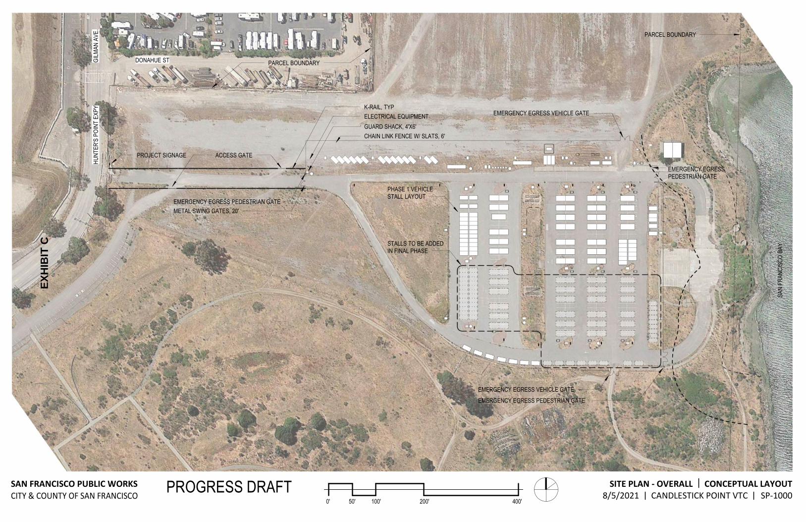
EXHIBITS:
A. Land Description
B. Site and Location Map
C. Safe Parking Area and Vehicle Triage Center
D. Endorsement of Sublease
RECOMMENDED ACTION:
It is recommended that the Commission:
CEQA FINDING: Find that the activity is exempt from the requirements of CEQA pursuant to
Government Code section 65660, as a statutorily exempt project; and California
Code of Regulations, title 14, section 15061 as a categorically exempt project, Class
1, Existing Facilities; California Code of Regulations, title 14, section 15301, and Class
3, New Construction or Conversion of Small Structures; California Code of
Regulations, title 14, section 15303.
PUBLIC TRUST AND STATE’S BEST INTERESTS: For all the above reasons, staff believes that the lease amendment and
endorsement of a sublease will not impact Public Trust resources and are in the best
interests of the State.
AUTHORIZATION: 1. Authorize the amendment of Lease Number PRC 6414, a General Lease – Public
Agency Use, of sovereign land, effective November 1, 2021, for the Low Barrier
Navigation Center within the CPSRA for a two-year term; and in addition to the
existing Exhibit A, Land Description and Exhibit B, Site and Location Map (for
reference purposes only), add Exhibit C, Candlestick Point VTC attached and
by this reference made a part hereof; all other terms and conditions shall remain
in effect without amendment.
2. Authorize the Executive Officer or her designee to execute an endorsement of
sublease for a period of no more than two years between the Lessee and
Sublessee for the temporary use of an existing paved parking lot and public
utilities for the Bayview Vehicle Triage Center.

EXHIBIT A
LAND DESCRIPTION PRC 6414
All that certain real property, including tide lands and submerged lands, whether filled or unfilled, situate in the City and County of San Francisco, State ofCalifornia, described as follows:
BEGINNING at the intersection of the northeasterly line of Underwood Avenue (formerly 21st
Avenue) with the northwesterly line of Arelious Walker Drive (formerly F Street) as said avenue and street is shown and so designated on that certain "Map of the Salt Marsh and Tide Lands and Lands Lying Under Water South ofSecond Street and Situate in the City and County Of San Francisco" filed in Map Book Wat Pages 46w47, Document Number X45805, Official Records of said City and County; thence along said northeasterly line South 53°18'15" East, 64.00 feet to the southeasterly line of said Arelious Walker Drive; thence South 36°42'0 l" West, 554.63 feet along the southeasterly line of said Arelious Walker Drive to the mean high tide line ofYosemite Slough; thence, along said mean high tide Jine of Yosemite Slough, with all its sinuosities, in the following three (3) general directions and distances:
(I) northwesterly 1,500 feet, more or less, (2) southwesterly 200 feet, more or less, and (3) southeasterly 1,500 feet, more or less, to the mean high tide line of San Francisco
Bay; thence, along said mean high tide of San Francisco Bay, with all its sinuosities, in the following seven (7) general directions and distances:
(1) southwesterly 600 feet, more or less, (2) southeasterly 2,600 feet, more or less, (3) · southwesterly 2,200 feet, more or less, (4) southeasterly 1,000 feet, more or less, (5) northeasterly 700 feet, more or less,
, (6) southeasterly 700 feet, more or less, and (7) westerly 200 feet, more or less. to the county line between San Mateo County and
said City and County of San Francisco; thence, westerly along said county line l,300 feet, more or less, to said mean high tide line of San Francisco Bay; thence, along said mean high tide line, with all its sinuosities, in a generally westerly direction 4,000 feet, more or less, to said county line; thence along said county line North 89°03'12" West, S0J 1 feet, more or less, to the southeasterly boundary ofHamey Way as designated and shown on that certain Map entitled ..Map Showing the Opening of Hamey Way from Jamestown to County Line", filed in Book U ofMaps at Pages 64 and 65 under Document No. N63258, in the office ofsaid Recorder;

Exhibit 23 Public Trust Parcels
thence along said southeasterly boundary North 45°5 l '33"East 516.68 feet; thence North 46°57'55" East 202.58 feet; . · thence from a tangent that bears North 46°3 8106" Ea~ along a non-tangent curve to the right, concave southeasterly, having a racUus of405.80 _feet, through a central angle of 7°01 '26", an arc distance of49.75 feet; ·
(1) South 56°53'02" East 282.67 feet, (2) North 66°1 5!) 5" East 89.60 feet, (3) North 45°25'04" East 85.86 feet, (4) North 70°06'35" East 121.71 feet, (5) South 60°39'53'1 East 88.05 feet, (6) South 43°15'05" East 119.42 feet, (7) South 63°50'44" East 133.57 feet, (8) South 54°07'51 ~ East 43.39 feet, (9) South 50°45'14" East 148.74 feet, (10) North 63°J J '31" East 102.86 feet, (I 1) North 36°20'30" East 235.12 feet, (12) North 59°53'58" East 233.55 feet, (13) North 73°48'1 2" East 214.43 feet, (14) South 8_5°22'26" East 87.38 feet, and (15) South 52°58'06" East 206.28 feet to a point on the southwesterly line ofJamestown
A venue as shown on Sheet l of4 of the "Map Showing the Widening and Extension ofJamestown Avenue from Hunters Point Expressway to Redondo Street'', filed in Book "U" ofMaps at Pages 60 through 63 under Document No. N63257 in the office of said Recorder;
thence along said southwesterly boundary ofJamestown from a tangent which bears South 41 °47' 17" East, along a non-tangent curve to the left, concave northeasterly. having a radius of 700.00 feet, through a central angle of47°15'56" anarc distance of 577.46 feet; thence continuing along said boundary and its easterly prolongation South 89°03'1 0" East 462.95 feet to a point from which said survey control monument "Candlestick" bears South 72 °41 '3 5" West 3583.66 feet; thence along the following seven (7) courses:
(I) South 52°04'06" East 57.17 feet, (2) North 77°30'04" East 56.70 feet, (3) North 88°03'0T' East 105.18 feet, (4) South 83°52'0T' East 152.76 feet, (5) North 58°35'30" East 54.42 feet, (6) North 03°29'53" West 712.73 feet, and (7) North 41 °59'03" West 355.46 feet to· a point on the easterly line of Hunters Point
Expressway as shown by the "Map Showing The Operung Of Hunters Point Expressway From Gilman A venue to County Line", a copy of which is filed in Map Book U, Page 59, Document N63256 in the Office of the Recorder, from which . survey control monument "Candlestick" described hereafter in the Basis ofBearing, bears South 60~08 '3 L" West 4086.48 foet;
thence along said easterly line ofHunters Point Expressway North 00°56'49" East 300.59 feet to a point from which said survey control monument "Candlestick" bears South 56°39'28" West 4248.28 feet; ·
2

Exhibit 23 Public Trust Parcels
thence leaving last said easterly line and along the following fourteen (14) courses: (I) South 53°17'46"East 483.43 feet,
·(2) North 28°29'56" East 181.80 feet, (3) North 33°06'40" East 343.27 feet, (4) North 20°18'03" East 267.80 feet, (5) North 26°20'05" East 149.63 feet, (6) North 68°45'03" East 206.80 feet, (7) North 39°58'07" East 215.81 feet, (8) North 09°36'28'' East 234.06 feet, (9) North 12°33'35" West 161.50 feet, (10) North 29°00'46" West 209.96 feet, (1 1) North 43°26'10" West 139.81 feet, (12) North 50°22'4 I" West 36.37 feet to a point from which srud survey control
monument "Candlestick" bears South 49°34,30" West 5884.36 feet, (13) South 48°00'38" West 806.04 feet, and (14) South 47°59'55" West 419.20 feet to the northeasterly line ofsaid Gilman Avenue;
thence along said Gilman Avenue North 53°18'15" West 323.38 feet to the southeasterly line of said Donahue Street; thence along said Donahue Street North 36°41 '45" East 1109.44 feet to a point from which said survey control monument "Candlestick" bears South 44°14'38" West 5693.66 feet; th(;nce the following nineteen (19) courses:
(1) North 00°45'03" West 250.63 feet, (2) North 53°19'14" West 96.45 feet, (3) South 65°07'25" West 168.91 feet, ( 4) North 53°18'15" West 173.94 feet. (5) North 25°19'23" West 11 7.62 feet, (6) North 42°34'38" West 75.09 feet,' (7) North 24°48'20" West 87.64 feet, (8) North 53°18'15" West 351.99 feet, (9) North 66°56'28'' West 177.17 feet, (I 0) North 53°18' 15" West 0.74 feet, (11) North 43°48'13" West 15.6 1 feet, (12) North 31°47'46" West 17.73 feet, (13) North 34°54'42" West37.l l feet, (14) North 11°34'22" West 28.96 feet, (15) North 37°09'59" West 6.16 feet, (16) North 05°05'26" West 173.61 feet, (17) North 29°54'22" East 201.41 feet, (18) North 24°22'08" East 263.40 feet, and (19) North 53°19'18" West 418.36 feet to the southeasterly line ofsaid Griffith Street,
from which point said survey control monument "Candlestick" bears South 25°41'14" West 6512.19 feet;
thence North 36°42'01" East 22.94 feet along said southeasterly line to the southwesterly line of Yosemite Avenue; thence along said southwesterly line North 53°18' 15" East 958.17 feet to the Agreed 1869 Ordinary High Water Mark described in Exhibit 25 to that certain Hunters Point
3
---------
Exhibit 23 Public Trust Parcels
Shipyard/Candlestick Point Title Settlement, Public Trust Exchange and Boundary Line Agreement recorded in Reel______, Image_ ____ , Document No.
, in the office ofsaid Recorder; thence in a generally northwesterly direction along said Agreed 1869 Ordinary High Water Mark 108 feet, more or less, to the northeasterly line ofsaid Yosemite Avenue; thence along said northeasterly line North 53°18' 15" West 94.03 feet to a point 205 feet southeasterly of, measured along last said northeasterly line from said Ingalls Street; thence North 36°42'01" East 200.00 feet to the southwesterly line of said Wallace Avenue to a point 205 feet southeasterly of, measured along last said southwesterly line, said Ingalls Street; thence along said southwesterly line South 53°18'15" East 52.48 feet to said Agreed 1869 Ordinary High Water; thence in a generally southeasterly direction along said Agreed 1869 Ordinary High Water Mark 277 feet, more or less, to the northeasterly line ofsaid Wallace Avenue; thence along said northeasterly line North 53°18'15" East 181 .63 to the southeasterly line of said Hawes Street; thence along said southeasterly line North 36°42'01" East 27.55 feet; thence South 53°19'18" East 587 .58 feet; thence South 03°34'00" West 22.28 feet; thence along the following four (4) courses:
(1) South 52°20'04" East 172.46 feet, (2) South 52°08'03" East 134.28 feet, (3) South 56°23'09" East 220.08 feet, and (4) South 83°01 '52" East 1~8.40 feet to the northwesterly line ofsaid Arelious Walker
Drive; thence along said northwesterly line North 36°42'01" East 466.08 feet to the northeasterly line of Underwood Avenue and the POINT OF BEGINNING.
BASIS OF BEARING of this description is North 37° 08' 31" East between found monuments designated and shown on that certain Record of Survey file? in Book AA of Maps at Pages 49 to 58 in the Office of the City and County of San Francisco Recorder as points "CANDLESTICK" (HPGN D CA 04 GF, PID-AB7679, EPOCH 1991 .35) and "US Navy Monument", a brass disk located at Innes Avenue and Earl Street with coordinates Northing 2,093,622.933 feet and Easting 6,020,345.522 feet.
DISTANCES in this description are U.S. Survey feet and decimals thereof and are "Ground" measurements per Survey Control Note No. 4 as shown on Sheet l ofsaid Record of Survey.
Unless otherwise noted herein all street citations are based upon that certain map entitled "Map of Lands Transferred in Trust to the City and County ofSan Francisco'' as approved by the State Land Commission on October 29, 1975 and March 25, 1976 on file in Liber Cl69 pages 573 to 664, Document Number Y 88209 dated September 1974 and said map filed in Map Book W Pages 66 to 72 inclusive in the office ofthe Recorder ofsaid City and County ofSan Francisco.
EXCEPTfNG THEREFROM all those portions lying within the following described Exception Parcels One through Four;
4

Exhibit 23 Public Trusl Parcels
Exception Parcel One
All that certain real property including tidelands and submerged land, whether filled or unfilled, situate in the City and County ofSan Francisco, State ofCalifornia and being portions of Arelious Walker Drive (Formerly F Street) between Underwood Avenue (Formerly 2151 Avenue) and Wallace Avenue (Formerly 2fd Avenue) all as designated and shown on that certain map entitled "Map ofthe Salt Marsh and Tide Lands and Lands Lying Under Water South ofSecond Street and Situate in the City and County Of San Francisco" approved by the Board ofTide Land Commissioners March 19,1869 and filed in Map Book Wat Pages 46-47, Document Number X45805, in the office of the Recorder ofsaid City and County ofSan Francisco described as follows:
BEGINNING at the intersection of the northeasterly line of said Underwood A venue with the northwesterly line of said Arelious Walker Drive; thence along said northeasterly line ofUnderwood Avenue South 53°18'15" East 64.00 feet to the southeasterly line ofsaid Arelious Walker Drive; thence South 36°42'01" W<:st 555.70 feet to the mean high tide line ofSan Francisco Bay; thence along said mean high tide line with all its sinuosities, westerly 74 feet, more or less, to said northwesterly line of Arelious Walker Drive; thence leaving said mean high tide Jine and along Jast said northwesterly line North 36°42'01" East 584.71 feet, more or less, to the POINT OF BEGINNING.
Exception Parcel Two
All that certain real property including tidelands and submerged land, whether filled or unfilled, situate in the City and County ofSan Francisco, State ofCalifornia and being portions of Arelious Walker Drive (Formerly F Street), Bancroft Avenue (Fotmerly 26th Avenue) and Block 807, all as designated and shown on that certain map entitled "Map of the Salt Marsh and Tide Lands and Lands Lying Under Water South ofSecond Street and Situate in the City and County Of San Francisco" approv()d by the Board ofTide Land Commissioners March 19, 1869 and filed in Map Book Wat Pages 46-47, Document Number X45805, in the office of the Recorder ofsaid City and County ofSan Francisco described as follows;
COMMENCING at the intersection of the northeasterly line ofCarroll Avenue (Formerly 27'h Avenue) as shown on said Map ofTidelands previously cited with the northwesterly line ofsaid Arelious Walker Drive;· thence along snid northwesterly line of Arelious Walker Drive North 36°42'01" East 166.79 feet to the TRUE POINT OF BEGINNING; thence leaving said northwesterly line South 05°05'26" East 21.78 feet; thence South 37°09'59,, East 6.16 feet; thence South 11°34'22" East 28.96 feet; thence South 34°54'42" East 37.11 feet; thence South 31 °47'46" East 17. 73 feet;
5

Exhibit 23 Public Trust ParcelS"
thence South 43°48'13" East 13.34 feet to a point from which survey control monument "Candlestick", described hereafter in the Basis of Bearings1 bears South 31 °22'22" West 5789.28 feet; thence North 36°41'45" East 123.04 feet, more or less, to the mean high tide line ofS_an Francisco Bay;
· thence along said mean high tide line, with all its sinuosities, northwesterly 134 feet, more or less, to said northwesterly line of Arclious Walker Drive; thence leaving said mean high tide line and along last said northwesterly line South 36°42'01 '' West 134.65 feet, more or less, to the TRUE POINT OF BEGINNING.
Exception Parcel Three
. All that certain real property including tidelands and submerged land, whether filled or unfilled, situate in the City and County of San Francisco, State of Califomi°a and being portions of Blocks 810,826,830, 844, to!etherwithportions ofDonner Avenue (Fonnerly 28th Avenue), Egbert Avenue (Formerly 29 Avenue) and Fitzgerald Avenue (Formerly 30th Avenue), all as . designated and shown on that ~rtain map entitled "Map ofthe Salt Marsh and Tide Lands and Lands Lying Under Water South ofSecond Street and Situate in the City and Cowity Of San Francisco" approved by the Board ofTide Land Commissioners March 19, 1869 and filed in Map Book Wat Pages 46-47, Document Number X45805, in the office of the Recorder ofsaid City and County ofSan Francisco, described as follows;
BEGINNING at the intersection of the northeasterly line of Gilman Avenue with the southeasterly line ofDonahue Street as said Avenue and Street are shown on said certain map entitled "Map of the Salt Marsh and Tide Lands Lying Under Water South of Second Street and Situate in the City and CoW1ty ofSan Francisco" previously cited; thence along said southeasterly line ofDonahue Street North 36°41 '45" East 933.86 feet to a point from which said survey control monument ''Candlestick bears South 44°29'00" West 5519.65 feet; thence leaving said southeasterly line, South 21 °59'15" East 16.88 feet; thence from a tangent which bears South 04° 02' 51" West along a curve to the right, concave westerly, having a radius of 390.00 feet, through a central angle 16° 38' 07'', an arc distance of 11323 feet; thence along a line parallel with said southeasterly line ofDonahue Street South 36°41 '45" West 655.1 1 feet; thence leaving said parallel line South 53°18'15" East 295.88 feet; thence South 4 7°59'55" West 182.68 feet; thence North 00°56'49" East 14.75 feet to said northeasterly line of Gilman Avenue; thence along said northeasterly line North 53°18'15" West 312.3 7 feet to the POINT OF BEGINNING.
Exception Parcel Four
All that certain real property including tidelands and submerged land, whether filled or unfilled, situate in the City and County of San Francisco, State ofCalifornia and being portions ofBlocks
6
Exhibit 23 Public Trust Parcels
860 and 857, together with portions oflngerson Avenue (Formerly 33rd
Avenue) as designated and shown on that certain•map entitled "Map of the Salt Marsh and Tide Lands and Lands Lying Under Water South of Second Street and Situate in the City and County Of San Francisco" approved by the Board of Tide Lnnd Commissioners March 19, 1869 and filed in Map Book W at Pages 46-47, Document Number X45805, in the office of the Recorder of said City and County ofSan Francisco, described as follows:
COMMENCING at the intersection of the northeasterly !foe ofGilman Avenue with the southeasterly line ofDonahue Street, as said Avenue and Street are shown on said certain map entitled "Map ofthe Salt Marsh and Tide Lands lying under water South of Second Street and s ituate in the City and County ofSan Francisco", previously cited; thence along said northeasterly line of Gilman Avenue South 53°18'15" East 312.37 feet; thence leaving said northeasterly line and along the easterly line ofHunters Point Expressway as shown by the "Map Showing The Opening OfHWlters Point Expressway From Gilman Avenue to County Line" a copy ofwhich is filed in Map Book U Page 59 Document N63256 in the Office of the Recorder ofsaid City and County, South 00°56'49" West 667.72 feet to the TRUE "POINT OF BEGINNING; thence South 53°18'15" East 105.06 feet to a point from which said survey control monument "Candlestick" bears South 57°58'42"West 4285.22 feet; thence South 36°41'45" West 96.78 feet; thence South 00°43'22" West 179.14 feet; thence South 89°16'38" East 1.50 feet; thence South 00°43'22" West 14.75 feet; thence North 41 °59'00" West 45.43feet to the said easterly line of said Hunters Point Expressway; thence along last said easterly line, North 00°56'49" East 300.5 1 feet to the TRUE POINT OF · BEGINNING.
The BASIS OF BEARINGS of this description is North 37°08' 3 l " East between found monuments designated and shown on that certain Record of Survey filed in Book AA ofMaps at Pages 49 to 58 in the Office ofthe City and County of San Francisco Recorder as survey control monuments "Candlestick" (HPGN D CA 04 GF, PID-AB7679, EPOCH 1991.35) and "US Navy Monument", a brass disk located at Innes Avenue and Earl Street with coordinates Northing 2,093,622.933 feet and Easting 6,020,345.522 feet.
DISTANCES in this description are ground measurements expressed in U.S. Survey per Survey Control Note No. 4 as shown on sheet 1 of said Record ofSurvey.
END OF DESCRIPTION
Prepared 3/30/2011 by the California State Lands Commission Boundary Unit
7

GILMAN AVENUE
CITY AND COUNTY OFSAN FRANCISCO
NO SCALE SITE
LEASE = AREA
ARELIOUS WALKER
DRIVE
HISTORIC SHORELINE
JAMESTOWN AVENUE
APPROXIMATE SHORELINE
SAN FRANCISCO
BAY
SAN FRANCISCO
BAY
FORMERLYHUNTERS POINT
EXPRESSWAY
HARNEY WAY
SAN MATEO COUNTY
CANDLESTICK POINT STATE RECREATION AREA (C.P.S.R.A.) NO SCALE LOCATION EXHIBIT B
PRC 6414 C.P.S.R.A. LEASE
AMENDMENT GENERAL LEASE -
PUBLIC AGENCY USE CITY & COUNTY OF SAN
FRANCISCO
SITE
SITE
CANDLESTICK POINT
MAP SOURCE: USGS QUAD
THIS EXHIBIT IS SOLELY FOR PURPOSES OF GENERALLY DEFINING THE LEASE PREMISES, IS BASED ON UNVERIFIED INFORMATION PROVIDED BY THE LESSEE OR OTHER PARTIES AND IS NOT INTENDED TO BE, NOR SHALL IT BE CONSTRUED AS, A WAIVER OR LIMITATION OF ANY STATE INTEREST IN THE SUBJECT OR ANY OTHER PROPERTY. JWP 10/6/2021
EXH
IBIT
C
ffi
' J ' : J
I I '
I I tr-1
r-
7
r-1
I
I I
I
f-4 f
-4 f
-j
' I'
I I
I
11
I I
I I
I L
_J
L_
J
L_
.J
I J
I
r ..
1 r
-,
r ,
I l
I I
I I
I I
I I
I I
r ·;
I -I r·
l 4
I I
• I
L.~
t .. ~
i..J
··□ ;-
-: ;·~
r-;
, ~-i
~-j
~-1
-.~
: :
l I
~ :
L_
J L
_J
l_J
''
' 1•
>1
'
''
' ,
I I
J \.
-J
r -
l r-
--,
' '
' '
r • l
f •
I I
'. !
: I.
.. J
L
,.J
\.
I r
... ,
r -
1 r-,
: II
f-1
1 l
I I
i-1 f-
j I
• t
I . '
' L
-J
L _
j ' '
I I
I I
L _
.J
L J
: ,lo
L
_J I I [(
BBB
8888
°
PARCEL BOUNDARY
DONAHUE ST PARCEL BOUNDARY
HU
NT
ER
'SP
OIN
TE
XP
Y
. E
VA
N
AMLI
G
K-RAIL, TYP EMERGENCY EGRESS VEHICLE GATE
ELECTRICAL EQUIPMENT
GUARD SHACK, 4'X6'
CHAIN LINK FENCE W/ SLATS, 6'
PROJECT SIGNAGE ACCESS GATE
EMERGENCY EGRESS PEDESTRIAN GATE
PHASE 1 VEHICLE STALL LAYOUT
EMERGENCY EGRESS PEDESTRIAN GATE
METAL SWING GATES, 20'
STALLS TO BE ADDED IN FINAL PHASE
EMERGENCY EGRESS VEHICLE GATE
EMERGENCY EGRESS PEDESTRIAN GATE
SA
NF
RA
NC
ISC
OB
AY
0' 50' 100' 200' 400'
SAN FRANCISCO PUBLIC WORKS
CITY & COUNTY OF SAN FRANCISCO
SITE PLAN - OVERALL CONCEPTUAL LAYOUT
8/5/2021 CANDLESTICK POINT VTC SP-1000 PROGRESS DRAFT
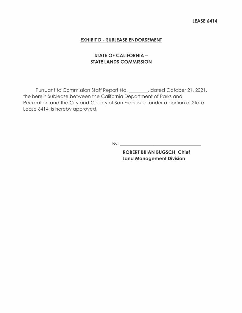
LEASE 6414
EXHIBIT D - SUBLEASE ENDORSEMENT
STATE OF CALIFORNIA –
STATE LANDS COMMISSION
Pursuant to Commission Staff Report No. ________, dated October 21, 2021,
the herein Sublease between the California Department of Parks and
Recreation and the City and County of San Francisco, under a portion of State
Lease 6414, is hereby approved.
By: __________________________________
ROBERT BRIAN BUGSCH, Chief
Land Management Division