staff report action required waterfront transit reset · staff report for action on waterfront...
TRANSCRIPT
Staff report for Action on Waterfront Transit "Reset" 1
STAFF REPORT ACTION REQUIRED
Waterfront Transit "Reset"
Date: October 9, 2015
To: Executive Committee
From: Deputy City Manager, Cluster B
Wards: 5, 6, 13, 14, 19, 20, 28, 30 and 32
Reference
Number: P:\2015\Cluster B\WF\EX15007
SUMMARY
At its June 10-12, 2015 meeting, Toronto City Council considered report PW4.1 entitled
"Gardiner Expressway and Lake Shore Boulevard East Reconfiguration Environmental
Assessment (EA) and Integrated Urban Design Study – Updated Evaluation of
Alternatives." Council adopted Clause 11 which reads as follows:
"City Council direct the City Manager to report to the October 20, 2015 Executive
Committee meeting on acceleration and costing of the East Bayfront LRT and
analysis of how its implementation would reduce travel times under the "Hybrid"
option."
This report responds to Council's request. Council's other Gardiner East EA directions
are being addressed in a series of other reports.
In considering Council’s request, staff have reviewed the broader waterfront transit
context and have concluded that there is a clear need for a “reset”. Recent waterfront
transit planning has been ad hoc and incremental, with the result that there is no larger
comprehensive plan for a transit network that can respond to the rapid transformation that
is occurring along the waterfront.
There has been significant growth in many precincts along the waterfront, including
South Etobicoke, Liberty Village, Fort York, King/Spadina, City Place, South Core, and
King/Parliament. Further, significant growth is planned for emerging precincts,
including Lower Yonge, East Bayfront, West Don Lands, North Keating, Port Lands and
the First Gulf site. There is currently a latent demand for transit south of Front Street as
witnessed by transit loading on the King and Harbourfront streetcar services. King
Street, for example, represents the most southerly continuous east/west transit line and is
EX9.9
Staff report for Action on Waterfront Transit "Reset" 2
regularly experiencing near or at-capacity conditions through much of the weekday peak
periods. The extent of latent and anticipated future demand creates an imperative for
defining a long-term transit solution as soon as possible.
Against this backdrop, numerous individual waterfront transit projects that would connect
to the existing 509 Harbourfront LRT exist in different stages of approval: some EAs are
in progress (Port Lands, Lower Yonge); some EAs have been approved but not
implemented (East Bayfront); and some EAs were started but never completed
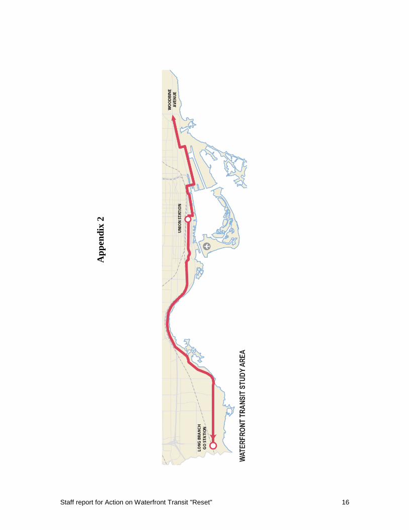
(Waterfront West). A map of proposed waterfront transit projects appears in Appendix 2.
As a consequence of not having a comprehensive transit network solution for the
waterfront, there has been little progress in securing funding for new transit infrastructure
in the area. Small amounts of committed funding exist in the City's Waterfront
Revitalization Initiative capital budget and from Waterfront Toronto's projected land
development revenues; however, no single waterfront transit project is close to being
funded and implemented.
Waterfront transit is largely absent from the robust program of transit infrastructure
investment currently underway and, to date, it is not under active consideration for any
funding that may be available through existing Provincial and Federal government
funding programs. This, in spite of the fact that both the Waterfront West and Waterfront
East LRTs are ranked in the top five unfunded rapid transit proposals in the preliminary
analysis undertaken by City Planning as part of the five-year review of Official Plan
transportation policies (known as "Feeling Congested?").
A comprehensive review of waterfront transit projects is needed immediately to articulate
the opportunities and options that exist, and to propose an approach to advance waterfront
transit. A preliminary Terms of Reference for this exercise, including a public
consultation strategy, has been drafted and attached as Appendix 1. It is anticipated that
the review would extend from the Long Branch GO Station in the west to Woodbine
Avenue in the east, and south of the Queensway/Queen Street corridor to Lake Ontario.
The work would lead to a plan for a continuous waterfront transit network with east/west
connectivity, as well as strong integrated north/south connections that would link the City
to the waterfront. This network would be further integrated with regional transit network
components, including the GO and subway systems, Smart Track and connections to
Scarborough.
The proposed review of waterfront transit initiatives and options would be undertaken by
a consultant reporting to a team of staff from the City, TTC and Waterfront Toronto. To
ensure expediency and maximum project oversight, it is recommended that the project be
managed by an interagency Executive Steering Committee, similar to the Port Lands
Acceleration Initiative. By Q2 of 2016, staff would provide a progress report to
Executive Committee on corridor options, preliminary costs, approvals and funding
opportunities. This would be followed by a final report to Executive Committee by the
end of Q3 outlining study recommendations and next steps. The reset would be
coordinated with the pending "Feeling Congested?" Official Plan transportation review

Staff report for Action on Waterfront Transit "Reset" 3
currently being undertaken by City Planning. Funds (up to $500,000) are available to
conduct the reset in the Waterfront Revitalization Initiative capital budget.
A reset on waterfront transit planning would be a first step towards a transit network that
can respond to the rapid transformation that is occurring along Toronto’s waterfront. It
would build on the momentum created by the three orders of government in supporting
waterfront revitalization. Further, it would prioritize projects that could be implemented
in a phased manner through “Waterfront 2.0”, and funded through development charges
and Provincial/Federal funding programs.
The other reporting matter requested by Council in the June 2015 direction and addressed
in this staff report concerns the potential of an East Bayfront LRT to reduce travel times
under the Gardiner East EA Hybrid option. The implementation of the East Bayfront
LRT, and a number of other transit improvements, were already assumed in the travel
time forecasts contained in staff's May 2015 Gardiner East EA report.
RECOMMENDATIONS
The Deputy City Manager, Cluster B, recommends that:
1. City Council direct City staff, working with the TTC and Waterfront Toronto, to
undertake a comprehensive review of waterfront transit initiatives and options,
and provide a status update to Executive Committee in Q2 of 2016; and
2. City Council direct City staff to fund the waterfront transit reset from the amount
allocated for East Bayfront Transit in the Waterfront Revitalization Initiative
capital project CWR003-10.
Financial Impact
The cost of retaining consulting services to assist the City, the TTC and Waterfront
Toronto in this exercise is estimated to be up to $500,000. Funding is available from the
Waterfront Revitalization Initiative capital project CWR003-10.
The Deputy City Manager and Chief Financial Officer has reviewed this report and agrees
with the financial impact information.
DECISION HISTORY
The following Council decision links deal with the importance of transit to accommodate
growth in Toronto's waterfront:
Central Waterfront Secondary Plan (2003)
http://www.toronto.ca/legdocs/2003/agendas/council/cc030414/plt5rpt/cl001.pdf

Staff report for Action on Waterfront Transit "Reset" 4
East Bayfront Precinct Plan and Class Environmental Assessment Master Plan (2005)
http://www.toronto.ca/legdocs/2005/agendas/council/cc051205/pof10rpt/cl002.pdf
East Bayfront Business and Implementation Plan (2006)
http://www.toronto.ca/legdocs/2006/agendas/council/cc060725/pof6rpt/cl009.pdf
Waterfront West Light Rail Transit (LRT) Environmental Assessment (2007)
http://www.ttc.ca/About_the_TTC/Commission_reports_and_information/Commission_
meetings/2007/Mar_21_2007/Other/Toronto_Transit_City.pdf
Metrolinx Regional Transportation Plan "The Big Move" Lake Shore West – introduction
of rapid transit along Lake Shore Road from Union Station to Port Credit (2008)
http://www.metrolinx.com/en/regionalplanning/bigmove/big_move.aspx
East Bayfront Transit Environmental Assessment: Streetcar Service on Queens Quay East
Between Yonge Street and Parliament Street (2009)
http://www.toronto.ca/legdocs/mmis/2009/cc/decisions/2009-09-30-cc40-dd.htm
East Bayfront LRT (2012)
http://app.toronto.ca/tmmis/viewAgendaItemHistory.do?item=2012.PG16.18
Five-Year Official Plan Review – "Feeling Congested?" (2013)
http://www1.toronto.ca/wps/portal/contentonly?vgnextoid=3649837c1b915410VgnVCM
10000071d60f89RCRD
The following link connects to the Council direction requesting this report: Gardiner
Expressway and Lake Shore Boulevard East Reconfiguration Environmental Assessment
(EA) and Integrated Urban Design Study – Updated Evaluation of Alternatives (2015)
http://app.toronto.ca/tmmis/viewAgendaItemHistory.do?item=2015.PW4.1
The following link connects to the Council decision on the Waterfront Strategic Review
(2015)
http://app.toronto.ca/tmmis/viewAgendaItemHistory.do?item=2015.EX7.6
The following link connects to a Council Member's Motion requesting transit service
improvements in the western waterfront: The Shoreline: Request for the City of Toronto
and the Toronto Transit Commission to provide improved transit for the City of Toronto's
western waterfront – by Councillor Mark Grimes, seconded by Councillor Josh Colle
(2015)
http://app.toronto.ca/tmmis/viewAgendaItemHistory.do?item=2015.MM9.23

Staff report for Action on Waterfront Transit "Reset" 5
ISSUE BACKGROUND
The attached study area map (Appendix 2) is a compilation of existing and proposed
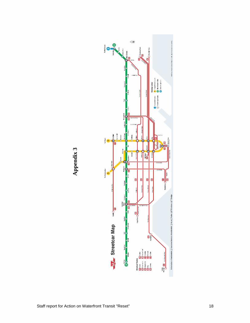
Waterfront LRT routes as understood today. A TTC streetcar map is also attached as
Appendix 3. The existing 509 Harbourfront LRT serves Queens Quay West to
Exhibition Place, with connections to Spadina Avenue and Bathurst Street. Westward
expansion of the LRT network has been proposed to run west from Union Station along
Bremner Boulevard, through Exhibition Place, to Park Lawn Road and South Etobicoke.
Eastward expansion of the LRT network would serve the emerging Lower Yonge and
East Bayfront neighbourhoods as part of a first phase; later phases would see the line
extended to the Port Lands, the First Gulf site and the Leslie Barns. The rationalization
of all these plans forms part of the work program in the proposed review.
Planning for a robust transit network which connects people and places to the renewed
waterfront is a key tenet of the Central Waterfront Secondary Plan adopted by Toronto
City Council in 2003. One of the "Big Moves" in the Plan is a new waterfront transit
network, "an extended Waterfront LRT across the Central Waterfront from Exhibition
Place to the Port Lands with excellent connections to the city". The plan calls for early
implementation of higher order transit before journey-to-work patterns are established, in
order to encourage transit-oriented travel patterns of residents and employees from the
outset. Expanded GO Transit rail services and an upgraded Union Station are also
referenced as critical elements of the new waterfront transit network.
Significant growth pressures in the western waterfront, in areas such as Humber Bay
Shores and Mimico, have highlighted the need for higher order transit west of Exhibition
Place. In 2006, at the direction of Toronto City Council, the TTC initiated an
Environmental Assessment (EA) for a proposed 11 kilometre Waterfront West LRT from
Union Station through Exhibition Place to the Long Branch GO Station. Ultimately, the
EA was never completed. Thus, the need for higher order transit enhancements in the
western waterfront is unresolved.
In the eastern waterfront, higher order transit is needed to facilitate the redevelopment of
Lower Yonge, East Bayfront, North Keating, the Port Lands and the future office node
planned for the First Gulf site; it would also connect to the Leslie Barns. Higher order
transit is key to achieving the aggressive employment targets planned for mixed-use
communities in the waterfront. East Bayfront, for example, has a minimum target of
25% employment-generating development for the precinct. Similarly, a split between
residential and employment uses is being assumed in the planning for the Port Lands.
The vision for the First Gulf site is that of a secondary hub for office and related
commercial uses, which will rely on higher order transit for its success.
As noted in the above Summary, the approach to dealing with existing demand and
planned growth to date has been ad hoc and incremental. The proposed waterfront transit
reset is intended to provide an urgent response to address this deficiency by producing a
comprehensive integrated network plan. This will facilitate decision-making regarding
phasing opportunities, acceleration options and funding.

Staff report for Action on Waterfront Transit "Reset" 6
COMMENTS
Growth Demand in the Waterfront
Since the approval of the Central Waterfront Secondary Plan in 2003, the areas in
proximity to Toronto's waterfront from South Etobicoke to the West Don Lands have
undergone significant transformation. New growth and revitalization is putting
immediate pressure on the transit network. King Street, for example, represents the most
southerly continuous east/west transit line and is regularly experiencing near or at-
capacity conditions through much of the weekday peak periods. South of King Street, as
can be seen in Appendix 3, there is no continuous east/west transit service
notwithstanding the levels of development and associated activity occurring in this area.
This imbalance is only expected to increase given the significant growth expected in
emerging precincts, including Exhibition Place/Ontario Place, Lower Yonge, East
Bayfront, North Keating, Port Lands and the First Gulf site. The extent of latent and
anticipated future travel demand creates an imperative for defining a transit solution as
soon as possible.
Waterfront Transit Funding
Notwithstanding the fact that both the Waterfront West and Waterfront East LRTs are
ranked in the top five unfunded rapid transit proposals in the preliminary analysis of
Feeling Congested?", there has been little funding allocated for waterfront transit
projects. The City's Waterfront Revitalization Initiative capital budget is carrying a small
allocation for East Bayfront Transit ($12 Million) and Waterfront Toronto is committed
to funding a portion of transit costs through future revenues. In addition, the Province
made a $200 Million funding commitment to the East Bayfront LRT in 2014, in relation
to the sale of the LCBO lands along Queens Quay. Even with these potential sources, the
gap in funding for waterfront transit remains substantial.
Coupled with the need to define a comprehensive waterfront transit solution is the need to
explore and tap into other potential funding sources. In July 2015, City Council
expressed its strong interest in continuing the tri-government waterfront revitalization
partnership. The City, through the Mayor, will be taking a leadership role by issuing a
Call to Action to Provincial and Federal leaders – a time-limited, formal and structured
intergovernmental negotiation process to confirm Waterfront 2.0 funding commitments.
Council confirmed four Waterfront 2.0 priorities: flood protection, waterfront transit,
land servicing and public realm. A fresh look at waterfront transit opportunities and
options, will allow the Mayor and City officials to more precisely articulate City
priorities for transit funding through the waterfront revitalization partnership and through
Provincial and Federal funding programs. Results from the comprehensive review of
waterfront transit projects can also be incorporated into the City's development charges
framework, the most rational way to fund municipal growth-related infrastructure.

Staff report for Action on Waterfront Transit "Reset" 7
Time for a Fresh Look at Waterfront Transit
A comprehensive review of waterfront transit initiatives and options is needed to explore
the opportunities and options that exist to advance waterfront transit, within the context
of the Central Waterfront Secondary Plan, as well as changes that have occurred since its
adoption in 2003. The Smart Track and Relief Line initiatives are being evaluated by the
City and TTC in close collaboration with Metrolinx. Metrolinx is also undertaking the
Regional Express Rail initiative in consultation with the City/TTC and other partners, to
consider significant upgrades to service on all the GO Transit corridors in the region.
Options for additional GO Transit Stations throughout the network are also being
evaluated as part of the initiative. New projects, such as the proposed First Gulf
redevelopment, have also emerged. Similarly, there is a renewed interest by the City and
Province in revitalizing Exhibition Place and Ontario Place. These changes are in
addition to the population and employment growth that continues to occur along the
waterfront.
Furthering the above-noted imperatives to take action on defining a waterfront transit
network solution is the recent Members Motion by Councillor Grimes (Ward 6) at the
September 30 - October 1, 2015 City Council meeting (MM9.23), recommending that:
"City Council request the City Manager and the Chief Executive Officer, Toronto
Transit Commission to report back in November 2015 to the Toronto Transit
Commission with a status update on:
a) Relocating the current TTC Humber Loop to Park Lawn Road and Lake Shore
Boulevard West, such report to contain cost projections and timelines for
relocation; and
b) "Closing the Gap" on a dedicated right-of-way from St. Joseph Hospital to
Exhibition Place and connecting options."
Also related to this motion, was item EY9.33 that was considered and adopted by
Etobicoke York Community Council on October 6, 2015, recommending that City
Council request the City Clerk to forward a copy of a letter from Councillors Mark
Grimes (Ward 6) and Justin Di Ciano (Ward 5) to Metrolinx, citing the urgency of, and
support for, a new GO Station at Park Lawn Road. This station is currently under review
as part of Metrolinx's "New Station Analysis" report.
Item a) from MM9.23 regarding the TTC Humber Loop extension and Item EY9.33
regarding the Park Lawn GO Station would both be included in the scope of work for the
upcoming Park Lawn/Lake Shore Transportation Master Plan study. The remaining Item
MM9.23 b) regarding "Closing the Gap" would be included in the scope of work
identified in Appendix 1.
All of this work will be closely coordinated and integrated as appropriate into the
Waterfront Transit Reset described herein.

Staff report for Action on Waterfront Transit "Reset" 8
Comprehensive Review of Waterfront Transit Projects – Work Program
A preliminary Terms of Reference for the Waterfront Transit Reset including a public
consultation component appears in Appendix 1. The proposed review would extend from
the Long Branch GO Station in the west to Woodbine Avenue in the east, and south of
the Queensway/Queen Street corridor to Lake Ontario.
The transit reset for the Waterfront LRT would address and update a number of factors as
they apply to the study area. The first priority would be to consider waterfront transit in
the context of local and regional transit initiatives. Key among these is the role that
transit along the waterfront can play in serving the access needs of the six million
residents of the Toronto region, of which 2.6 million are within the City. Toronto's
waterfront is a unique regional asset and must be made accessible by a network of quality
transit services, ideally linking to a main east-west distributor spine. This network would
need to be integrated with regional transit components, including the GO and subway
systems, Smart Track and connections to Scarborough.
Once this overall context has been established and refined, an update of the ridership
potential of a new waterfront transit line, using the City's new transit model, would be
undertaken. The ridership projections would be linked to land use growth, anticipated
potential to facilitate revitalization projects, and assumptions regarding connections to the
larger transit network. These factors would all be considered as part of an initial network
assessment. Other remaining components of the work would include preliminary costing,
priority phasing for implementation, and next steps in the decision-making and approvals
process.
Staff are proposing to retain a consulting team that would report to a staff team from the
City, TTC and Waterfront Toronto. To ensure expediency and maximum project
oversight, it is recommended that the project be managed by an interagency Executive
Steering Committee, similar to the Port Lands Acceleration Initiative. By Q2 of next
year, a progress report would be provided to Executive Committee on the way forward
including details on a funding strategy and the necessary approvals process. This would
be followed by a final report in Q3 outlining recommendations emanating from the
assessment and public engagement, and next steps necessary to deliver a phased program
of needed waterfront transit improvements. The reset would be coordinated with the
pending "Feeling Congested?" Official Plan transportation review.
The work program for this study will have oversight by staff of Waterfront Toronto.
However, the staff of the Transportation Planning Section, City Planning, will be
responsible for managing the consultant to deliver the transit plan and related details
outlined in this report, including technical analysis as required. Budget Committee
recently requested the Chief Planner and Executive Director to report on this unit's work
program and ability to undertake new work, including waterfront transit planning. In the
context of this report, the need for new staff positions to respond to waterfront transit
priorities is required.

Staff report for Action on Waterfront Transit "Reset" 9
Implementation of East Bayfront Transit and the "Hybrid" Option
The other reporting matter requested by Council in the June 2015 direction and addressed
through this staff report concerns the potential of an East Bayfront LRT to reduce travel
times under the Gardiner East EA Hybrid option. The implementation of the East
Bayfront LRT, and a number of other transit improvements, were already assumed in the
travel time forecasts contained in staff's May 2015 Gardiner East EA report.
The transit improvements assumed in the transportation modelling work for the Gardiner
EA are critical to realizing the land use vision for the waterfront, and were considered as
part of the future base conditions before any options for the road network were assessed.
Based on an understanding of work already completed, and assuming that land use
growth projections are valid, removing the East Bayfront LRT from the model
assumptions would be expected to negatively impact local traffic and transit conditions in
the Central Waterfront and the Port Lands, and create a disconnect in the continuous
transit service.
As part of the reset, the 1.6-kilometre East Bayfront LRT will be studied further. The
preferred alternative arising from the 2010 East Bayfront Transit EA, provides for a new
passenger platform at 45 Bay Street (across from the Air Canada Centre) and extensive
new tunneling below Bay and Queens Quay. These items represent over 50% of the $520
Million project budget ($2016) and approximately 80% of the capital cost relating
directly to constructing transit. The remaining costs are for rolling stock and
reconstruction of Queens Quay.
The breakdown of the $520 Million East Bayfront LRT is as follows:
New eastbound passenger platform: $112 Million
Extension of Bay Street tunnel to Freeland Street: $156 Million
Surface infrastructure: $66 Million
Rolling stock: $36 Million
Queens Quay revitalization: $150 Million
As part of the reset, staff would explore options to reduce East Bayfront transit project
costs and/or develop East Bayfront transit incrementally. A review of options to ensure
the project is not delayed indefinitely is warranted.

Staff report for Action on Waterfront Transit "Reset" 10
Conclusion
A reset on waterfront transit planning would be a first step towards a transit network that
can respond to the rapid transformation that is planned and presently occurring along
Toronto’s larger waterfront. It would build on the momentum created by the three orders
of government in revitalizing Toronto's waterfront. Further, it would prioritize projects
that could be implemented in a phased manner through “Waterfront 2.0”, and funded
through development charges and Provincial/Federal funding programs.
CONTACTS David Stonehouse, Director Tim Laspa, Director
Waterfront Secretariat Transportation Planning
[email protected] [email protected]
416 392-8113 416-392-8100
Hilary Holden, Director
Transit & Sustainable Transportation
416-338-2577
SIGNATURE
_______________________________
John W. Livey, F.C.I.P
Deputy City Manager, Cluster B
ATTACHMENTS
Appendix 1: Comprehensive Review of Waterfront Transit Network, Preliminary Terms
of Reference
Appendix 2: Study Area Maps
Appendix 3: TTC Streetcar Map
Staff report for Action on Waterfront Transit "Reset" 11
Appendix 1
Comprehensive Review of Waterfront Transit Network
Preliminary Terms of Reference
The following Preliminary Terms of Reference is based on the background information
and history regarding waterfront transit service, and more importantly, the need to
consider a comprehensive and continuous connected solution to realize growth and
accommodate travel in a sustainable manner.
1. Study Design
The study area for the comprehensive review will address the area from Lake Shore
Boulevard at Long Branch in the west, Woodbine Ave and Queen Street in the east, and
generally south of the Queensway/Queen Street. The study area will be reviewed and
refined as necessary at the Study Design stage.
The study design will also describe the issues and the opportunities for transit to best
serve the long-term vision and revitalization of Toronto's waterfront. The key issue is the
lack of a continuous waterfront transit service, and some of the specific concerns are
crowding on the King streetcar line and the increasing demand for transit service from
completed development projects. Opportunities that would be created by a new line
include fulfilling a key City objective for a comprehensive "transit first" solution to
accommodating future growth, and the opportunity to support revitalization options for
Exhibition Place, Ontario Place, the Port Lands and other key sites along the waterfront.
2. Review of Background Material
Waterfront revitalization and transit planning in the City has a long history, and all
relevant information and documents will be made available. The information deals with
previous route selection and assessment, relevant approvals secured, and estimated costs.
The consulting team will be required to review and become familiar with this material.
3. Update Baseline Conditions
Existing conditions in the study area, including land use growth, travel behavior patterns,
and road and transit improvements will all be updated to reflect current conditions. This
is a key step before considering the future conditions, and the exercise must also capture
the significant amount of change that is currently underway.
4. Local and Regional Transit Plans
Transit in the City and region has been the subject of a great deal of planning and
forecasting in recent years. A key task will be to establish the latest planning
assumptions from the TTC, Metrolinx and the City as they pertain to the waterfront. This

Staff report for Action on Waterfront Transit "Reset" 12
would include TTC service improvements, Metrolinx Regional Express Rail, Union
Station and Scarborough transit connections, as well as the City's latest work on Smart
Track and the Relief Line, as well as the "Feeling Congested?" update to the Official
Plan.
5. Land Use Growth and Transportation Trends
The transportation modelling analysis for the future considers land use and transportation
assumptions for the Greater Toronto Area, but a more detailed assessment of the study
area will be required. This assessment will consider input from City staff regarding
significant new development projects, as well as any currently anticipated changes to the
transportation network.
6. Transit Modelling Sensitivity Test of the Waterfront LRT
The City's transportation model will be used to assess the large scale implications of the
future condition with and without a Waterfront LRT line. The consulting team will be
required to conduct a more detailed study area analysis using an appropriate
transportation modelling assessment tool that captures the transit planning sensitivities in
the project study area. This work will help to confirm the initial problem and
opportunities evaluation task.
7. Identify Transit Routes for Evaluation
The selection of transit route alternatives will first consider a strategic overview, and will
then focus down to the confirmation of transit technology based on problem/opportunity
assessment, background information, transit modelling for future base conditions, policy
direction, cost, ridership potential, and other relevant factors. The study will consider up
to six route options or variations on portions of individual routes. Potential routes for
consideration would include Lake Shore Boulevard, the Queensway, Rail/Gardiner
Corridor, redevelopment lands (e.g., Exhibition Place and Ontario Place), Fort
York/Bremner Boulevard, Front Street, Queens Quay, Commissioners Street, as well as
north-south connections. The options will be considered in the context of a network
solution that best meets the project objectives in the context of the City's Official Plan
policies.
8. Develop Evaluation Criteria
The successful Proponent shall develop a comprehensive set of evaluation criteria for the
assessment of alternative route solutions. The criteria will reflect City, TTC, Waterfront
Toronto and Metrolinx policies and official direction as they pertain to the solutions.
Other important criteria to be considered include the following:
Transit ridership forecast;
Network connections (efficiency, access to and links between local and regional
transit);

Staff report for Action on Waterfront Transit "Reset" 13
Revitalization opportunities for underdeveloped sites and reuse of sites;
Ease of implementation and cost;
Ability to relieve congestion on existing transit lines;
Potential to ease Gardiner congestion;
Compatibility with growth projections, traffic operation implications; and
Preliminary economic, social, natural environment, heritage and aboriginal
implications.
This list will be further revised during the study design phase and will consider public
and stakeholder input.
Based on the evaluation assessment, three shortlisted transit solutions will be selected for
further evaluation.
9. Modelling Evaluation of Alternative Transit Solutions
The three shortlisted transit solutions will be assessed using the City's transportation
model, and this information will be considered in a second-round evaluation assessment.
The three options will then be ranked in terms of overall scoring.
10. Preliminary Cost Estimates
A key component of the study will be an assessment of the constructability and related
costs for the three shortlisted transit solutions.
11. Deliverables
The consulting team will produce a final study report documenting the results of the
work, and recommending three alternative solutions for further study under the Transit
Project Assessment Process (TPAP). Attendance at City Committee and Council
meetings are also anticipated after the final report is submitted.
12. Next Steps
At the conclusion of the study, staff will recommend the next steps towards the approval,
and funding of a waterfront transit solution, as well as potential phasing strategies for
implementation.
13. Proposed Public Consultation Plan
The anticipated scope of this study covers a large section of the City's waterfront from
Long Branch in the west to Woodbine Avenue in the east, and will require an appropriate
level of public consultation. This consultation will include both the general public, as
well as key stakeholders in the west, central and east areas of the study area. At the
feasibility study stage, it is estimated that up to two public meetings will be required for

Staff report for Action on Waterfront Transit "Reset" 14
the three areas for a total of six meetings. In addition, two stakeholder meetings, for a
total of eight meetings, will be held at the project initiation and at the draft findings stage.
Public Consultation Guiding Principles
It is intended that the Public Consultation Plan reflect a framework that is consistent with
the approach that has been successfully applied in City Planning's public engagement on
other rapid transit projects including SmartTrack, the Relief Line and Scarborough
Subway Extension. Specifically, the goal of the project's proposed public consultation
program will be to generate broad participation by integrating residents, businesses, and
key interest groups into a participatory public engagement process.
As an initial approach, the scope of public consultation work should consider the
following principles:
Inclusiveness: engage the widest possible audience through multiple consultation
opportunities;
Timeliness: offer early and ongoing opportunities for participation well before
decisions are made;
Transparency: participation will be widely communicated through multiple
communications channels;
Balance: provide opportunities for a diversity of perspectives and opinions to be
raised and considered;
Flexibility: adapt as required to meet the needs of participants; and,
Traceability: demonstrate the impact of participant input on decision-making.
Proposed Public Consultation Framework
The proposed Public Consultation Framework will be developed by City Planning staff
with expertise in designing consultation plans. At this point, it is suggested the
consultation program could be comprised of two rounds of consultation; one for the study
commencement and one to review draft findings from the review, prior to interim
reporting to Executive Committee. Each round will provide the public with opportunity
to learn about the project and its progress, ask questions, share ideas, and voice concerns.
As a suggested approach, each round could include:
Interactive public open houses in three geographic areas of the City spanning the
proposed Study Area;
Stakeholder engagement meetings and/or workshops;
Internet-based information sharing through a City project website and social
media; and
Documentation of all public and stakeholder commentary received.
Staff report for Action on Waterfront Transit "Reset" 15
Local City Councillors will be briefed in advance of public consultation and will have an
opportunity to preview material to be presented at upcoming public and stakeholder
meetings.
A stakeholder roster will be compiled, in consultation with local City Councillors, and
may include, but not necessarily be limited to: ratepayer groups/associations, other local
interest and/or advocacy groups, Business Improvement Areas, professional associations,
and industry experts.
As previously noted consultation can be a joint effort or coordinated with Waterfront
Toronto, TTC and Metrolinx, tailored to the range of issues in the study area. All
communication will be coordinated for this review.
Communications
A project website will be developed and maintained for the duration of the project. The
website will mirror face-to-face consultations at public forums. All material displayed
and presented at public open houses will be posted on the study’s website. It will also
include any published background reports and public notices. A project specific email
address will be established to provide for direct online communication between the public
and the study team.
Public and Stakeholder Meeting Consultation Summary Reports
At this point it is proposed that brief summary reports be prepared for all public and
stakeholder meetings, consisting of the following:
The purpose of the meeting;
A description of the meeting venue, format and number of attendees;
A general description of the meeting participants and/or name(s) of the
stakeholder group(s);
Notes identifying the questions raised and the responses to the questions;
Summary of recurrent themes, comments or recommended directions; and,
Documentation of presentation material.
Individual summary reports could be consolidated into a single public consultation
document at the conclusion of each round of consultation, and posted on the project
website.
Staff report for Action on Waterfront Transit "Reset" 16
Ap
pen
dix
2

Staff report for Action on Waterfront Transit "Reset" 17
Ap
pen
dix
2
Staff report for Action on Waterfront Transit "Reset" 18
Ap
pen
dix
3