stage 1-2 archaeological assessment: spencer pit ... city spencer pit... · stage 1-2...
TRANSCRIPT
Stage 1-2 Archaeological Assessment: Spencer Pit, Additional Lands
Wellington Road 124, Part of Lot 17, Concession B, Geographic Township of Guelph, now Township of Guelph-Eramosa, Wellington County, Ontario.
Prepared for: Mr. Rick Esbaugh Tri City Lands Ltd. 2264 Snyders Road P.O. Box 209 Petersburg, ON N0B 2M0 Tel: (519) 634-5110 Fax: (519) 634-1004 Email: [email protected]
Prepared by: Stantec Consulting Ltd. 200 – 835 Paramount Drive Stoney Creek, ON L8J 0B4 Tel: (905) 385-3234 Fax: (905) 385-3534
Licensee: Parker Dickson, MA License #: P256 PIF #: P256-0149-2014 Project #: 160940272
ORIGINAL REPORT
May 28, 2014
STAGE 1-2 ARCHAEOLOGICAL ASSESSMENT: SPENCER PIT, ADDITIONAL LANDS
jm l:\01609\active\160940272 - spencer pit additional lands st1-2\work_program\report\final\p256-0149-2014_28may2014_re.docx i
Table of Contents
EXECUTIVE SUMMARY ................................................................................................................ III
PROJECT PERSONNEL ................................................................................................................ IV
ACKNOWLEDGEMENTS ............................................................................................................. IV
1.0 PROJECT CONTEXT ....................................................................................................... 1.1 1.1 DEVELOPMENT CONTEXT ................................................................................................. 1.1
1.1.1 Objectives ....................................................................................................... 1.1 1.2 HISTORICAL CONTEXT ...................................................................................................... 1.2
1.2.1 Pre-contact Aboriginal Archaeological Resources ................................. 1.2 1.2.2 Post-contact Aboriginal Archaeological Resources ............................... 1.3 1.2.3 Historic Euro-Canadian Resources .............................................................. 1.4
1.3 ARCHAEOLOGICAL CONTEXT ........................................................................................ 1.5 1.3.1 The Natural Environment .............................................................................. 1.5 1.3.2 Previously Known Archaeological Sites and Surveys ............................... 1.5 1.3.3 Archaeological Potential ............................................................................. 1.6 1.3.4 Existing Conditions ......................................................................................... 1.7
2.0 FIELD METHODS ............................................................................................................. 2.1
3.0 RECORD OF FINDS ........................................................................................................ 3.1
4.0 ANALYSIS AND CONCLUSIONS ................................................................................... 4.1
5.0 RECOMMENDATIONS ................................................................................................... 5.1
6.0 ADVICE ON COMPLIANCE WITH LEGISLATION........................................................... 6.1
7.0 BIBLIOGRAPHY AND SOURCES .................................................................................... 7.1
8.0 IMAGES .......................................................................................................................... 8.1 8.1 PHOTOGRAPHS ................................................................................................................. 8.1
9.0 MAPS ............................................................................................................................. 9.1
10.0 CLOSURE ...................................................................................................................... 10.1
LIST OF TABLES Table 1: Cultural Chronology of Wellington County .............................................................. 1.2 Table 2: Inventory of Documentary Record ............................................................................ 3.1
LIST OF FIGURES Figure 1: Location of Study Area ............................................................................................... 9.2 Figure 2: Treaties and Purchases, adapted from Morris 1943 ............................................... 9.3
STAGE 1-2 ARCHAEOLOGICAL ASSESSMENT: SPENCER PIT, ADDITIONAL LANDS
jm l:\01609\active\160940272 - spencer pit additional lands st1-2\work_program\report\final\p256-0149-2014_28may2014_re.docx ii
Figure 3: Portion of the 1906 Map of Guelph Township ......................................................... 9.4 Figure 4: Stage 2 Survey Methods ............................................................................................. 9.5
STAGE 1-2 ARCHAEOLOGICAL ASSESSMENT: SPENCER PIT, ADDITIONAL LANDS
jm l:\01609\active\160940272 - spencer pit additional lands st1-2\work_program\report\final\p256-0149-2014_28may2014_re.docx iii
Executive Summary
Stantec Consulting Ltd. was retained by Tri City Lands Ltd. to conduct a Stage 1-2 archaeological assessment for a study area located on Wellington Road 124, Part of Lot 17, Concession B, Geographic Township of Guelph, now Township of Guelph-Eramosa, Wellington County, Ontario. The study area consists of 0.74 hectares of land, consisting of manicured lawn and existing disturbances such as a tar and chip laneway and residence.
This assessment was conducted to meet the requirements of Section 2.2.4 and Section 2.2.5 of the Provincial Standards under the Aggregate Resources Act, R.S.O. c.A.8 (Government of Ontario 1990a), prior to the submission of site plan applications to the Ministry of Natural Resources. Moreover, this assessment was conducted in accordance with the Ministry of Tourism, Culture and Sport’s (MTCS) 2011 Standards and Guidelines for Consultant Archaeologists (Government of Ontario 2011).
The objectives of the Stage 1 assessment were to compile all available information about the known and potential archaeological heritage resources within the study area and to provide specific direction for the protection, management and/or recovery of these resources. The objectives of the Stage 2 assessment were to provide an overview of archaeological resources on the property and to determine whether any of the resources might be artifacts and archaeological sites with cultural heritage value or interest and to provide specific direction for the protection, management and/or recovery of these resources.
The Stage 1 archaeological assessment resulted in the determination that portions of the study area exhibit a moderate to high potential for the identification and recovery of archaeological resources. The Stage 2 archaeological assessment was conducted on May 6, 2014. No archaeological resources were identified. No further work is recommended for the study area.
The MTCS is asked to review the results presented and accept this report into the Ontario Public Register of Archaeological Reports.
The Executive Summary highlights key points from the report only; for complete information and findings, the reader should examine the complete report.
STAGE 1-2 ARCHAEOLOGICAL ASSESSMENT: SPENCER PIT, ADDITIONAL LANDS
jm l:\01609\active\160940272 - spencer pit additional lands st1-2\work_program\report\final\p256-0149-2014_28may2014_re.docx iv
Project Personnel
Licensed Archaeologist: Parker Dickson, MA (P256)
Project Manager: Jeffrey Muir, BA (R304)
Licensed Field Director: Helen Ohlke, MA (R427)
Field Technicians: Matt Seguin (R1018), Gemma Calgie (R472)
Report Writer: Gemma Calgie, B.Sc. (R472)
Technical Review: Jeffrey Muir, BA (R304)
Licensee Review Parker Dickson, MA (P256)
Senior Review: Tracie Carmichael, BA, B.Ed. (R140)
Acknowledgements
Proponent Contact: Rick Esbaugh – Tri City Lands Ltd.
Ministry of Tourism, Culture and Sport: Robert von Bitter

STAGE 1-2 ARCHAEOLOGICAL ASSESSMENT: SPENCER PIT, ADDITIONAL LANDS
Project Context May 28, 2014
jm l:\01609\active\160940272 - spencer pit additional lands st1-2\work_program\report\final\p256-0149-2014_28may2014_re.docx 1.1
1.0 PROJECT CONTEXT
1.1 DEVELOPMENT CONTEXT
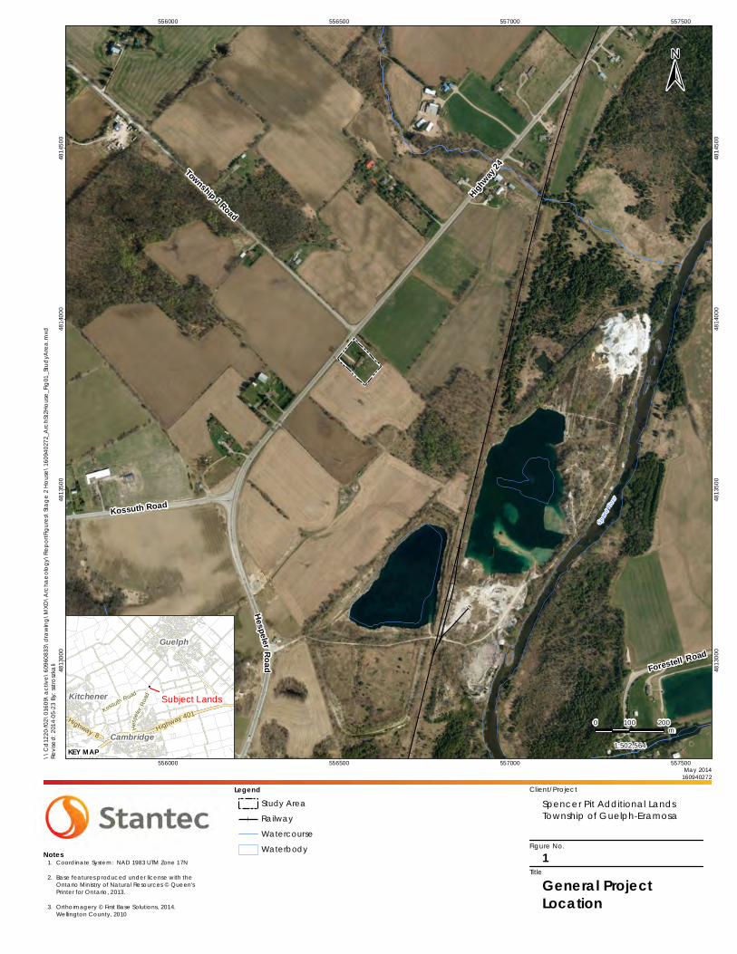
Stantec Consulting Ltd. (Stantec) was retained by Tri City Lands Ltd. (Tri City) to conduct a Stage 1-2 archaeological assessment for a study area located on Wellington Road 124, Part of Lot 17, Concession B, Geographic Township of Guelph, now Township of Guelph-Eramosa, Wellington County, Ontario (Figure 1). The study area encompasses of 0.74 hectares of land, consisting of manicured lawn and existing disturbances such as a tar and chip laneway and residence.
This assessment was conducted to meet the requirements of Section 2.2.4 and Section 2.2.5 of the Provincial Standards under the Aggregate Resources Act, R.S.O. c.A.8 (Government of Ontario 1990a), prior to the submission of site plan applications to the Ministry of Natural Resources. Moreover, this assessment was conducted in accordance with the Ministry of Tourism, Culture and Sport’s (MTCS) 2011 Standards and Guidelines for Consultant Archaeologists (Government of Ontario 2011).
Permission to enter the study area to document and remove archaeological resources was provided by Rick Esbaugh of Tri City.
1.1.1 Objectives
For the purposes of this Stage 1 -2 archaeological assessment, the MTCS’s 2011 Standards and Guidelines for Consultant Archaeologists (Government of Ontario 2011) were followed. The objective of the Stage 1 background study is to document the property’s archaeological and land use history and present conditions. This information was used to support recommendations regarding cultural heritage value or interest as well as assessment and mitigation strategies. The Stage 1 research information was drawn from:
The MTCS’ Archaeological Sites Database (ASDB) for a listing of registered archaeological sites within a one-kilometre radius of the study area;
Reports of previous archaeological assessments within a radius of 50 metres around the property;
Recent and historical maps of the property area;
Archaeological management plans or other archaeological potential mapping when available;
Commemorative plaques or monuments if applicable; and
Visual inspection of the project area.

STAGE 1-2 ARCHAEOLOGICAL ASSESSMENT: SPENCER PIT, ADDITIONAL LANDS
Project Context May 28, 2014
jm l:\01609\active\160940272 - spencer pit additional lands st1-2\work_program\report\final\p256-0149-2014_28may2014_re.docx 1.2
The objectives of the Stage 2 assessment were to document archaeological resources present within the study area, to determine whether any of the resources might be artifacts or archaeological sites with cultural heritage value or interest requiring further assessment, and to provide specific Stage 3 direction for the protection, management and/or recovery of the identified archaeological resources (Government of Ontario 2011).
1.2 HISTORICAL CONTEXT
The study area consists of 0.74 hectares of manicured lawn surrounding a residence with a tar and chip laneway located on Part of Lot 17, Concession B, Geographic Township of Guelph, now Township of Guelph-Eramosa, Wellington County, Ontario.
1.2.1 Pre-contact Aboriginal Archaeological Resources
This portion of southwestern Ontario has been demonstrated to have been occupied by people as far back as 11,000 years ago as the glaciers retreated. For the majority of this time, people were practicing hunter gatherer lifestyles with a gradual move towards more extensive farming practices. Table 1 provides a general outline of the cultural chronology of Wellington County, based on Ellis and Ferris (1990).
Table 1: Cultural Chronology of Wellington County
Period Characteristics Time Period Comments
Early Paleo-Indian Fluted Projectiles 9000 - 8400 B.C. spruce parkland/caribou hunters
Late Paleo-Indian Hi-Lo Projectiles 8400 - 8000B.C. smaller but more numerous sites
Early Archaic Kirk and Bifurcate Base Points 8000 - 6000 B.C. slow population growth
Middle Archaic Brewerton-like points 6000 - 2500 B.C. environment similar to present
Late Archaic
Lamoka (narrow points) 2000 - 1800 B.C. increasing site size
Broad Points 1800 - 1500 B.C. large chipped lithic tools
Small Points 1500 - 1100B.C. introduction of bow hunting
Terminal Archaic Hind Points 1100 - 950 B.C. emergence of true cemeteries
Early Woodland Meadowood Points 950 - 400 B.C. introduction of pottery
Middle Woodland Dentate/Pseudo-Scallop Pottery 400 B.C. - A.D.500 increased sedentism
Princess Point A.D. 550 - 900 introduction of corn
Late Woodland
Early Ontario Iroquoian A.D. 900 - 1300 emergence of agricultural villages
Middle Ontario Iroquoian A.D. 1300 - 1400 long longhouses (100m +)
Late Ontario Iroquoian A.D. 1400 - 1650 tribal warfare and displacement
Contact Aboriginal Various Algonkian Groups A.D. 1700 - 1875 early written records and
treaties
Late Historic Euro-Canadian A.D. 1796 -present European settlement
STAGE 1-2 ARCHAEOLOGICAL ASSESSMENT: SPENCER PIT, ADDITIONAL LANDS
Project Context May 28, 2014
jm l:\01609\active\160940272 - spencer pit additional lands st1-2\work_program\report\final\p256-0149-2014_28may2014_re.docx 1.3
1.2.2 Post-contact Aboriginal Archaeological Resources
The post-contact Aboriginal occupation of Southern Ontario was heavily influenced by the dispersal of various Iroquoian-speaking communities by the New York State Iroquois and the subsequent arrival of Algonkian-speaking groups from northern Ontario at the end of the 17th century and beginning of the 18th century (Konrad 1981; Schmalz 1991). By 1690, Algonkian speakers from the north appear to have begun to repopulate Bruce County (Roger 1978:761). This is the period in which the Mississaugas are known to have moved into southern Ontario and the lower Great Lakes watersheds (Konrad 1981). In southwestern Ontario, however, members of the Three Fires Confederacy (Chippewa, Ottawa, and Potawatomi) were immigrating from Ohio and Michigan in the late 1700s (Feest and Feest 1978:778-779).
The nature of Aboriginal settlement size, population distribution, and material culture shifted as European settlers encroached upon their territory. However, despite this shift, “written accounts of material life and livelihood, the correlation of historically recorded villages to their archaeological manifestations, and the similarities of those sites to more ancient sites have revealed an antiquity to documented cultural expressions that confirms a deep historical continuity to Iroquoian systems of ideology and thought” (Ferris 2009:114). As a result, First Nations peoples of Southern Ontario have left behind archaeologically significant resources throughout Southern Ontario which show continuity with past peoples, even if they have not been recorded in historical Euro-Canadian documentation.
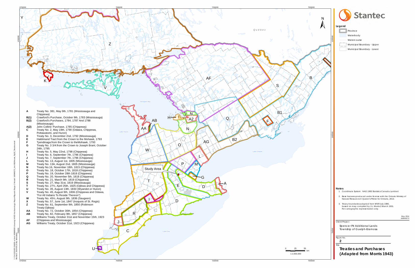
The study area first enters the Euro-Canadian historic record in 1792 as part of Treaty Number 3. Treaty Number 3 was:
…made with the Mississa[ug]a Indians 7th December, 1792, though purchased as early as 1784. This purchase in 1784 was to procure for that part of the Six Nation Indians coming into Canada a permanent abode.
The area included in this Treaty is, Lincoln County excepting Niagara Township; Saltfleet, Binbrook, Barton, Glanford and Ancaster Townships, in Wentworth County; Brantford, Onondaga, Tusc[a]r[o]ra, Oakland and Burford Townships in Brant County; East and West Oxford, North and South Norwich, and Dereham Townships in Oxford County; North Dorchester Township in Middlesex County; South Dorchester, Malahide and Bayham Township in Elgin County; all Norfolk and Haldimand Counties; Pelham, Wainfleet, Thorold, Cumberland and Humberstone Townships in Welland County… .
(Morris 1943: 17-18)
While it is difficult to exactly delineate treaty boundaries today, Figure 2 provides an approximate outline of Treaty Number 3 (identified by the letter “D”).
Given the location of the study area is in close proximity to the Speed River and is part of the Grand River watershed, the post-contact Aboriginal archaeological potential of the study area is judged to be moderate to high.
STAGE 1-2 ARCHAEOLOGICAL ASSESSMENT: SPENCER PIT, ADDITIONAL LANDS
Project Context May 28, 2014
jm l:\01609\active\160940272 - spencer pit additional lands st1-2\work_program\report\final\p256-0149-2014_28may2014_re.docx 1.4
1.2.3 Historic Euro-Canadian Resources
The criteria used by the MTCS to determine potential for historic archaeological sites include the presence of: 1) particular, resource-specific features that would have attracted past subsistence or extractive uses; 2) areas of initial, non-Aboriginal settlement; 3) early historic transportation routes; and 4) properties designated under the Ontario Heritage Act (Government of Ontario 1990c).
The study area falls within the former Township of Guelph, now Township of Guelph-Eramosa, Wellington County, Ontario. Originally belonging to The District of Wellington formed in 1838, Wellington County was named after Arthur Wellesley, the First Duke of Wellington. In 1854, Wellington County became an individual entity incorporating 12 Townships and Towns, including the independent Townships of Eramosa and Guelph. The amalgamation of the Township of Guelph, Township of Eramosa, and parts of the Townships of Pilkington and Nichol, to form the Township of Guelph-Eramosa was established in 1999.
The 1906 Historical Atlas of the County of Wellington, Ont.’s map of the Township of Guelph lists Jacob Miller as the landowner for Lot 17 (Historical Atlas Publishing 1906). The study area is located at the extreme northeastern corner of the lot, along Wellington Road 124, which at the time was a major route to the town of Guelph. No structures in this Lot are visible on the map. However, historical county atlases were produced primarily to identify factories, offices, residences and landholdings of subscribers and were funded by subscription fees. Landowners who did not subscribe were not always listed on the maps (Caston 1997: 100). As such, all structures were not necessarily depicted or placed accurately (Gentilcore and Head 1984). By 1906 the current road system was constructed and is still recognizable today.
The Great Western Railway is depicted in the 1906 Historical Atlas of the County of Wellington, Ont.’s map of the Township of Guelph. A portion of this railway runs northeast – southwest through the southeastern corner of Lot 17. In 1834, the London and Gore Railroad Company was incorporated and in 1845, changed its name to the Great Western Rail Road Company (Currie 1957). Later, in 1853, the company name changed again to the Great Western Railway. The rail line from Galt, Ontario to Guelph, Ontario was completed in 1857 (Currie 1957). The railway enjoyed initial financial success, but following the depression of 1857 it began to suffer. After decades of fierce competition with rival rail lines, the Great Western Rail Road Company was purchased by the Grand Trunk Railway in 1882 (Currie 1957).
The majority of the region surrounding the study area has been subject to European-style agricultural practices for over 100 years, having been settled by Euro-Canadian farmers by the mid-19th century. Much of the region today continues to be used for agricultural purposes. Considering the above, the historic Euro-Canadian archaeological potential of the study area was judged to be moderate to high.

STAGE 1-2 ARCHAEOLOGICAL ASSESSMENT: SPENCER PIT, ADDITIONAL LANDS
Project Context May 28, 2014
jm l:\01609\active\160940272 - spencer pit additional lands st1-2\work_program\report\final\p256-0149-2014_28may2014_re.docx 1.5
1.3 ARCHAEOLOGICAL CONTEXT
The Stage 1-2 assessment for the study area was conducted on May 6, 2014 under PIF P256-0149-2014 issued to Parker Dickson, MA by the MTCS. The study area consists of 0.74 hectares of manicured lawn surrounding a residence and its associated tar and chip laneway.
1.3.1 The Natural Environment
The study area is situated within the Guelph Drumlin Field region, as identified by Chapman and Putnam (1984). The Guelph Drumlin Fields consist of a general landform pattern containing drumlins or groups of drumlins fringed by gravel terraces and separated by swampy valleys in which slow moving tributaries of the Grand River are located (Chapman and Putnam 1984:138). The till in these drumlins is loamy and calcareous, containing fragments of underlying red shale (Chapman and Putnam). Moreover, “[T]he soils of the drumlins are classed in the Guelph catena which contains the predominant, well-drained Guelph loam…it is fertile, easily worked, and adaptable to many crops” (Chapman and Putnam 1984:138).
Potable water is the single most important resource for any extended human occupation or settlement and since water sources in southwestern Ontario have remained relatively stable over time, proximity to drinkable water is regarded as a useful index for the evaluation of archaeological site potential. In fact, distance to water is one of the most commonly used variables for predictive modeling of archaeological site location in Ontario. The closest extant source of potable water to the study area is a small tributary of the Speed River 530 metres northeast of the study area, while the Speed River itself is located approximately 770 metres to the east. The Speed River is a tributary of the larger Grand River, located approximately seven kilometres to the west of the study area.
1.3.2 Previously Known Archaeological Sites and Surveys
In order to compile an inventory of archaeological resources, the registered archaeological site records kept by the MTCS were consulted. In Ontario, information concerning archaeological sites stored in the ASDB is maintained by the MTCS. This database contains archaeological sites registered according to the Borden system. Under the Borden system, Canada is divided into grid blocks based on latitude and longitude. A Borden Block is approximately 13 kilometres east to west and approximately 18.5 kilometres north to south. Each Borden Block is referenced by a four-letter designator and sites within a block are numbered sequentially as they are found. The study area under review is within Borden Block AiHb.
Information concerning specific site locations is protected by provincial policy, and is not fully subject to the Freedom of Information and Protection of Privacy Act. The release of such information in the past has led to looting or various forms of illegally conducted site destruction. Confidentiality extends to all media capable of conveying location, including maps, drawings, or textual descriptions of a site location. The MTCS will provide information concerning site

STAGE 1-2 ARCHAEOLOGICAL ASSESSMENT: SPENCER PIT, ADDITIONAL LANDS
Project Context May 28, 2014
jm l:\01609\active\160940272 - spencer pit additional lands st1-2\work_program\report\final\p256-0149-2014_28may2014_re.docx 1.6
location to the party or an agent of the party holding title to a property, or to a licensed archaeologist with relevant cultural resource management interests.
An examination of the ASDB has shown that no archaeological sites have been registered within a one-kilometre radius of the study area (personal communication, Robert von Bitter, October 28, 2013; Government of Ontario n.d.).
One archaeological study has been undertaken within 50 metres of the study area: Stage 1–2 Archaeological Assessment: Spencer Pit, Part of Lots 14-18, Concession B Township of Guelph–Eramosa, Wellington County, Ontario (Stantec 2013). The area was determined to have archaeological potential for both Aboriginal and Euro-Canadian sites. The Stage 2 archaeological assessment resulted in the identification and documentation of two small Euro–Canadian artifact scatters. It was determined that neither scatter contained cultural heritage value or interest and no further archaeological assessment was recommended (Stantec 2013).
1.3.3 Archaeological Potential
Archaeological potential is established by determining the likelihood that archaeological resources may be present on a subject property. Stantec applied archaeological potential criteria commonly used by MTCS (Government of Ontario 2011) to determine areas of archaeological potential within the region under study. These variables include proximity to previously identified archaeological sites, distance to various types of water sources, soil texture and drainage, glacial geomorphology, elevated topography and the general topographic variability of the area.
Distance to modern or ancient water sources is generally accepted as the most important determinant of past human settlement patterns and, considered alone, may result in a determination of archaeological potential. However, any combination of two or more other criteria, such as well-drained soils or topographic variability, may also indicate archaeological potential. Finally, extensive land disturbance can eradicate archaeological potential (Wilson and Horne 1995).
As discussed above, distance to water is an essential factor in archaeological potential modeling. When evaluating distance to water it is important to distinguish between water and shoreline, as well as natural and artificial water sources, as these features affect sites locations and types to varying degrees. The MTCS categorizes water sources in the following manner:
Primary water sources: lakes, rivers, streams, creeks;
Secondary water sources: intermittent streams and creeks, springs, marshes and swamps;
Past water sources: glacial lake shorelines, relic river or stream channels, cobble beaches, shorelines of drained lakes or marshes; and

STAGE 1-2 ARCHAEOLOGICAL ASSESSMENT: SPENCER PIT, ADDITIONAL LANDS
Project Context May 28, 2014
jm l:\01609\active\160940272 - spencer pit additional lands st1-2\work_program\report\final\p256-0149-2014_28may2014_re.docx 1.7
Accessible or inaccessible shorelines: high bluffs, swamp or marshy lake edges, sandbars stretching into marsh.
The closest primary source of extant potable water is a small unnamed tributary of the Speed River. This tributary is also depicted on the 1906 Historical Atlas of the County of Wellington, Ont.’s map of the Township of Guelph. The Grand River, of which the Speed River is a tributary, is located approximately seven kilometres to the west of the study area. Additional ancient and/or relic tributaries of the Speed River, or the Grand River, may have existed but are not identifiable today and are not indicated on historic mapping.
Soil texture can be an important determinant of past settlement, usually in combination with other factors such as topography. As indicated previously, soil within the Guelph Drumlin Fields is fertile, easily worked and adaptable to many different crops. These characteristics indicate that the soil in this region would be suitable for pre-contact Aboriginal agriculture.
For Euro-Canadian sites, archaeological potential can be extended to areas of early Euro-Canadian settlement, including places of military or pioneer settlements; early transportation routes; and properties listed on the municipal register or designated under the Ontario Heritage Act or property that local histories or informants have identified with possible historical events. The Historical Atlas for the County of Wellington, Ont. demonstrates that the study area and its environs were densely occupied by Euro-Canadian inhabitants by the later 19th century. Much of the established road system and agricultural settlement from that time is still visible today.
When the above listed criteria are applied to the study area, the archaeological potential for pre-contact Aboriginal, post-contact Aboriginal, and historic Euro-Canadian sites is deemed to be moderate to high. Thus, in accordance with Section 1.3.1 of the Standards and Guidelines for Consultant Archaeologists (Government of Ontario 2011), the Stage 1 archaeological assessment of the Spencer Pit Additional Lands has determined that the study area exhibits moderate to high potential for the identification and recovery of archaeological resources.
1.3.4 Existing Conditions
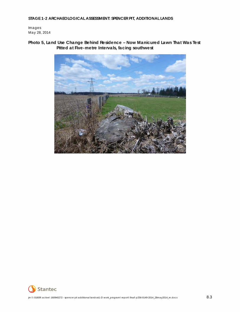
The study area comprises 0.74 hectares of land. The majority of the study area (approximately 90%) consists of manicured lawn. The remaining portion of the study area (approximately 10%) consists of previous construction disturbances, including a tar and chip laneway and an existing house. The southeastern portion of the study area, which had previously been active agricultural field, was converted to manicured lawn between 2006 and 2009 and had a wire fence erected around it (Photo 5). This fenced area now forms a part of the manicured lawn associated with the existing residence and is inaccessible for ploughing.
STAGE 1-2 ARCHAEOLOGICAL ASSESSMENT: SPENCER PIT, ADDITIONAL LANDS
Field Methods May 28, 2014
jm l:\01609\active\160940272 - spencer pit additional lands st1-2\work_program\report\final\p256-0149-2014_28may2014_re.docx 2.1
2.0 FIELD METHODS
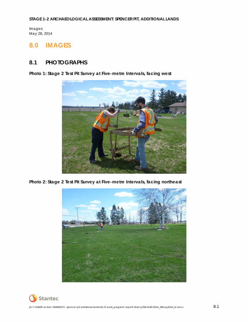
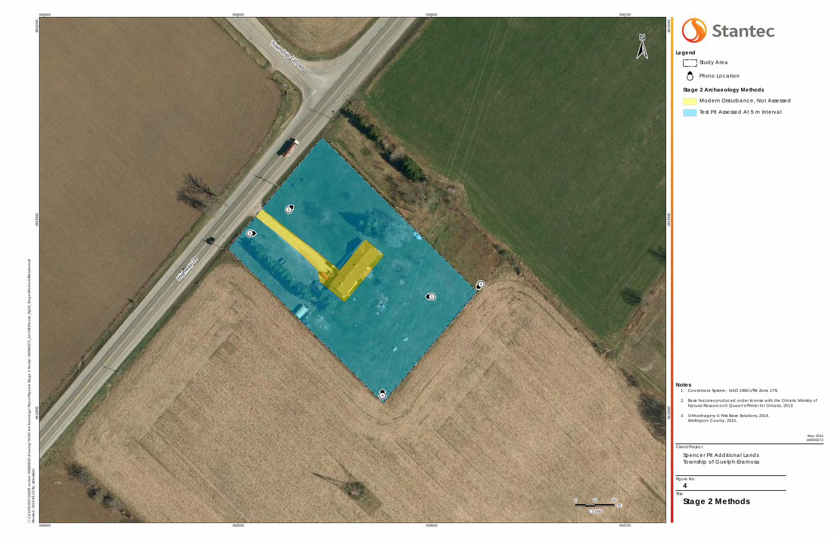
The Stage 1-2 assessment of the Spencer Pit Additional Lands study area was conducted on May 6, 2014 under PIF P256-0149-2014, issued to Parker Dickson, MA by the MTCS. During the Stage 2 survey, assessment conditions were excellent and at no time were the field, weather, or lighting conditions detrimental to the recovery of archaeological material. Photos 1 to 3 confirm that field conditions met the requirements for a Stage 2 archaeological assessment, as per the Standards and Guidelines for Consultant Archaeologists (Section 7.8.6 Standard 1a; Government of Ontario 2011). Figure 4 provides an illustration of the Stage 2 assessment methods, as well as photograph locations and directions.
Approximately 90% of the study area consists of manicured lawn that was inaccessible for ploughing. This area was subject to test pit assessment at a five metre interval (Photos 1 and 2) in accordance with Section 2.1.2 of the MTCS’s 2011 Standards and Guidelines for Consultant Archaeologists (Government of Ontario 2011). The test pit assessment was conducted within one metre of all modern existing structures within the study area, as per Section 2.1.2 Standard 4 of the above document. Each test pit was approximately 30 centimetres in diameter and excavated five centimetres into sterile subsoil. The soils were then examined for stratigraphy, cultural features, or evidence of fill. All soil was screened through six millimetre mesh hardware cloth to facilitate the recovery of small artifacts and then used to backfill the pit. No further archaeological methods were employed since no artifacts were recovered during the test pit survey.
The remaining 10% of the study area was not assessed due to previous construction disturbances and existing structures, including a tar and chip laneway and an existing house (Photos 3 and 4). While these areas were not assessed, they were photo documented (Section 7.8.6 Standard 1b; Government of Ontario 2011).
STAGE 1-2 ARCHAEOLOGICAL ASSESSMENT: SPENCER PIT, ADDITIONAL LANDS
Record of Finds May 28, 2014
jm l:\01609\active\160940272 - spencer pit additional lands st1-2\work_program\report\final\p256-0149-2014_28may2014_re.docx 3.1
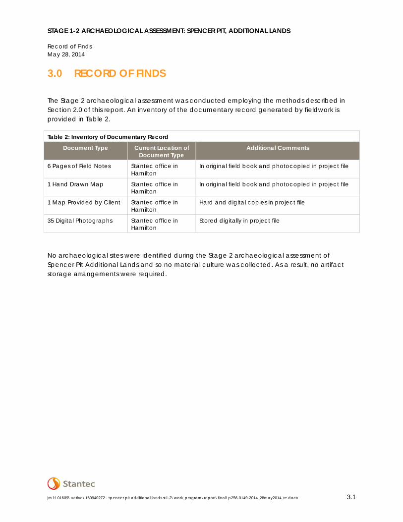
3.0 RECORD OF FINDS
The Stage 2 archaeological assessment was conducted employing the methods described in Section 2.0 of this report. An inventory of the documentary record generated by fieldwork is provided in Table 2.
Table 2: Inventory of Documentary Record
Document Type Current Location of Document Type
Additional Comments
6 Pages of Field Notes Stantec office in Hamilton
In original field book and photocopied in project file
1 Hand Drawn Map Stantec office in Hamilton
In original field book and photocopied in project file
1 Map Provided by Client Stantec office in Hamilton
Hard and digital copies in project file
35 Digital Photographs Stantec office in Hamilton
Stored digitally in project file
No archaeological sites were identified during the Stage 2 archaeological assessment of Spencer Pit Additional Lands and so no material culture was collected. As a result, no artifact storage arrangements were required.

STAGE 1-2 ARCHAEOLOGICAL ASSESSMENT: SPENCER PIT, ADDITIONAL LANDS
Analysis and Conclusions May 28, 2014
jm l:\01609\active\160940272 - spencer pit additional lands st1-2\work_program\report\final\p256-0149-2014_28may2014_re.docx 4.1
4.0 ANALYSIS AND CONCLUSIONS
Stantec was retained by Tri City to conduct a Stage 1-2 archaeological assessment for a study area located on Wellington Road 124, Part of Lot 17, Concession B, Geographic Township of Guelph, now Township of Guelph-Eramosa, Wellington County, Ontario. The Stage 1 archaeological assessment of the Spencer Pit Additional Lands study area determined that the entire study area exhibits moderate to high potential for the identification and recovery of archaeological resources. As such, a Stage 2 archaeological assessment was recommended. No archaeological sites were identified during the Stage 2 assessment.
STAGE 1-2 ARCHAEOLOGICAL ASSESSMENT: SPENCER PIT, ADDITIONAL LANDS
Recommendations May 28, 2014
jm l:\01609\active\160940272 - spencer pit additional lands st1-2\work_program\report\final\p256-0149-2014_28may2014_re.docx 5.1
5.0 RECOMMENDATIONS
The Stage 1-2 assessment of the Spencer Pit Additional Lands study area did not identify any archaeological sites, and therefore no further archaeological assessment is required.
The MTCS is asked to review the results presented and accept this report into the Ontario Public Register of Archaeological Reports.

STAGE 1-2 ARCHAEOLOGICAL ASSESSMENT: SPENCER PIT, ADDITIONAL LANDS
Advice on Compliance with Legislation May 28, 2014
jm l:\01609\active\160940272 - spencer pit additional lands st1-2\work_program\report\final\p256-0149-2014_28may2014_re.docx 6.1
6.0 ADVICE ON COMPLIANCE WITH LEGISLATION
This report is submitted to the Ontario Minister of Tourism, Culture and Sport as a condition of licensing in accordance with Part VI of the Ontario Heritage Act, R.S.O. 1990, c 0.18 (Government of Ontario 1990b). The report is reviewed to ensure that it complies with the standards and guidelines that are issued by the Minister, and that the archaeological fieldwork and report recommendations ensure the conservation, protection and preservation of the cultural heritage of Ontario. When all matters relating to archaeological sites within the project area of a development proposal have been addressed to the satisfaction of the Ministry of Tourism, Culture and Sport, a letter will be issued by the ministry stating that there are no further concerns with regard to alterations to archaeological sites by the proposed development.
It is an offence under Sections 48 and 69 of the Ontario Heritage Act for any party other than a licensed archaeologist to make any alteration to a known archaeological site or to remove any artifact or other physical evidence of past human use or activity from the site, until such time as a licensed archaeologist has completed fieldwork on the site, submitted a report to the Minister stating that the site has no further cultural heritage value or interest, and the report has been filed in the Ontario Public Register of Archaeology Reports referred to in Section 65.1 of the Ontario Heritage Act.
Should previously undocumented archaeological resources be discovered, they may be a new archaeological site and therefore subject to Section 48(1) of the Ontario Heritage Act. The proponent or person discovering the archaeological resources must cease alteration of the site immediately and engage a licensed consultant archaeologist to carry out archaeological fieldwork, in compliance with Section 48(1) of the Ontario Heritage Act.
The Cemeteries Act, R.S.O. 1990 c. C.4 and the Funeral, Burial and Cremation Services Act, 2002, S.O. 2002, c.33 (when proclaimed in force) require that any person discovering human remains must notify the police or coroner and the Registrar of Cemeteries at the Ontario Ministry of Consumer Services.
STAGE 1-2 ARCHAEOLOGICAL ASSESSMENT: SPENCER PIT, ADDITIONAL LANDS
Bibliography and Sources May 28, 2014
jm l:\01609\active\160940272 - spencer pit additional lands st1-2\work_program\report\final\p256-0149-2014_28may2014_re.docx 7.1
7.0 BIBLIOGRAPHY AND SOURCES
Caston, Wayne A. 1997. Evolution in the Mapping of Southern Ontario and Wellington County. Wellington County History 10:91-106.
Chapman, Lyman John and Donald F. Putnam. 1984. The Physiography of Southern Ontario. 3rd ed. Ontario Geological Survey Special Volume 2. Toronto: Ministry of Natural Resources.
Currie, A.W. 1957. The Grand Trunk Railway of Canada. University of Toronto Press, Toronto.
Ellis, Chris J. and Neal Ferris (editors). 1990. The Archaeology of Southern Ontario to A.D. 1650. Occasional Publication of the London Chapter, Ontario Archaeological Society, Number 5.
Gentilcore, Louis R. and C. Grant Head. 1984. Ontario’s History in Maps. Toronto: University of Toronto Press, Scholarly Publishing Division.
Historical Atlas Publishing Co. 1906. Historical Atlas of the County of Wellington, Ontario. Historical Atlas Publishing Co., Toronto. Reprint 1972.
Government of Ontario. 1990a. Aggregate Resources Act, R.S.O. 1990. Last amendment: 2009, c. 33, Sched. 2, s. 3. Electronic document: http://www.e-laws.gov.on.ca/html/statutes/english/elaws_statutes_90a08_e.htm. Last accessed May 22, 2014.
Government of Ontario. 1990bc. Ontario Heritage Act, R.S.O. 1990, CHAPTER O.18. Last amendment: 2009, c. 33, Sched. 11, s. 6. Electronic document: http://www.e-laws.gov.on.ca/html/statutes/english/elaws_statutes_90o18_e.htm. Last accessed May 22, 2014.
Government of Ontario. 2011. Standards and Guidelines for Consultant Archaeologists. Toronto: Ministry of Tourism, Culture and Sport.
Government of Ontario. n.d. Archaeological Sites Database (ASDB) Files. Toronto: Archaeology Program Unit, Ministry of Tourism, Culture and Sport.
Morris, J.L. 1943. Indians of Ontario. 1964 reprint. Toronto: Department of Lands and Forests.
Schmalz, Peter S. 1991. The Ojibwa of Southern Ontario. Toronto: University of Toronto Press.
Stantec Consulting Ltd. 2013. Stage 1-2 Archaeological Assessment: Spencer Pit, Part of Lots 14-18, Concession B Township of Guelph-Eramosa, Wellington County, Ontario. Report on file with the Ministry of Tourism, Culture and Sport, Toronto.

STAGE 1-2 ARCHAEOLOGICAL ASSESSMENT: SPENCER PIT, ADDITIONAL LANDS
Bibliography and Sources May 28, 2014
jm l:\01609\active\160940272 - spencer pit additional lands st1-2\work_program\report\final\p256-0149-2014_28may2014_re.docx 7.2
Wilson, J.A. and M. Horne 1995. City of London Archaeological Master Plan. London: City of London, Department of Planning and Development.
STAGE 1-2 ARCHAEOLOGICAL ASSESSMENT: SPENCER PIT, ADDITIONAL LANDS
Images May 28, 2014
jm l:\01609\active\160940272 - spencer pit additional lands st1-2\work_program\report\final\p256-0149-2014_28may2014_re.docx 8.1
8.0 IMAGES
8.1 PHOTOGRAPHS
Photo 1: Stage 2 Test Pit Survey at Five-metre Intervals, facing west
Photo 2: Stage 2 Test Pit Survey at Five-metre Intervals, facing northeast

STAGE 1-2 ARCHAEOLOGICAL ASSESSMENT: SPENCER PIT, ADDITIONAL LANDS
Images May 28, 2014
jm l:\01609\active\160940272 - spencer pit additional lands st1-2\work_program\report\final\p256-0149-2014_28may2014_re.docx 8.2
Photo 3: Modern Disturbance from Existing Tar and Chip Laneway and Residence, facing east
Photo 4: Modern Disturbance from Existing Residence, facing north
STAGE 1-2 ARCHAEOLOGICAL ASSESSMENT: SPENCER PIT, ADDITIONAL LANDS
Images May 28, 2014
jm l:\01609\active\160940272 - spencer pit additional lands st1-2\work_program\report\final\p256-0149-2014_28may2014_re.docx 8.3
Photo 5, Land Use Change Behind Residence – Now Manicured Lawn That Was Test Pitted at Five-metre Intervals, facing southwest

STAGE 1-2 ARCHAEOLOGICAL ASSESSMENT: SPENCER PIT, ADDITIONAL LANDS
Maps May 28, 2014
jm l:\01609\active\160940272 - spencer pit additional lands st1-2\work_program\report\final\p256-0149-2014_28may2014_re.docx 9.1
9.0 MAPS
All maps will follow on succeeding pages.
Speed
River
Kossuth Road
Forestell Road
HespelerRoad
Township 1 Road
Highway
24
556000
556000
556500
556500
557000
557000
557500
557500
481
300
0
481
300
0
481
350
0
481
350
0
481
400
0
481
400
0
481
450
0
481
450
0
1:502,564
\\C
d12
20-f0
2\01
609\
act
ive\
6096
0833
\dra
win
g\M
XD\A
rcha
eol
ogy
\Rep
ortF
igur
es\S
tag
e 2
Ho
use\
1609
4027
2_A
rchS
t2H
ous
e_Fi
g01
_Stu
dyA
rea
.mxd
Revi
sed:
201
4-05
-23
By: s
stro
szka
li
Study Area
Railway
Watercourse
Waterbody
±
May 2014160940272
Client/Project
Spencer Pit Additional LandsTownship of Guelph-Eramosa
Figure No.
1Title
General ProjectLocation
Coordinate System: NAD 1983 UTM Zone 17N
Base features produced under license with the Ontario Ministry of Natural Resources © Queen's Printer for Ontario, 2013.
Orthoimagery © First Base Solutions, 2014.Wellington County, 2010
Guelph
Kitchener
Cambridge
Subject LandsKos
suth
Road
Hes
pele
rR
oad
Highway 8Highway 401
KEY MAP
Notes1.
2.
3.
Legend
0 100 200m
Y
Z
AF
S
T
C
O
D
W
AG
D
V
E
R
P
L
NAA
I
M
J
A
FA2
K
HN
G
U
AB
B2
B1
Q
B
Study Area
Lake Huron
Lake Erie
Lake Ontario
Georgian Bay
Lake Superior
Lake SuperiorQ u é b e c
6750000
6750000
7000000
7000000
7250000
7250000
7500000
7500000
7500
00
7500
00
1000
000
1000
000
1250
000
1250
000
Client/Project
Figure No.
Title
Treaties and Purchases(Adapted from Morris 1943)
2
Spencer Pit Additional LandsTownship of Guelph-Eramosa
May 2014160940272
Notes
Legend
1.
2.
3.
Coordinate System: NAD 1983 Statistics Canada Lambert
Base features produced under license with the Ontario Ministry of Natural Resources © Queen's Printer for Ontario, 2013.
Treaty boundaries adapted from MNR July 1980, based on map compiled by J.L. Morris 2 March 1931. For cartographic representation only.
0 25 50km
1:2,500,000
Province
Waterbody
Watercourse
Municipal Boundary - Upper
Municipal Boundary - Lower
\\C
d12
20-f0
2\01
609\
act
ive\
6096
0833
\dra
win
g\M
XD\A
rcha
eolo
gy\R
epor
tFig
ures
\Sta
ge
2 H
ous
e\16
0940
272_
Arc
hSt2
Ho
use_
Fig
02_T
rea
ties.
mxd
Revi
sed:
201
4-05
-23
By: s
stro
szka
li
±
AB(1)B(2)A(2)CDEFGHIJLMNOPQRSTUVWXZAAABAFAG
Treaty No. 381, May 9th, 1781 (Mississauga andChippewa)Crawford's Purchase, October 9th, 1783 (Mississauga)Crawford's Purchases, 1784, 1787 And 1788(Mississauga)John Collins' Purchase, 1785 (Chippewa)Treaty No. 2, May 19th, 1790 (Odawa, Chippewa,Pottawatomi, and Huron)Treaty No. 3, December 2nd, 1792 (Mississauga)Haldimand Tract:from the Crown to the Mohawk, 1793Tyendinaga:from the Crown to theMohawk, 1793Treaty No. 3 3/4:from the Crown to Joseph Brant, October24th, 1795Treaty No. 5, May 22nd, 1798 (Chippewa)Treaty No. 6, September 7th, 1796 (Chippewa)Treaty No. 7, September 7th, 1796 (Chippewa)Treaty No. 13, August 1st, 1805 (Mississauga)Treaty No. 13A, August 2nd, 1805 (Mississauga)Treaty No.16, November 18th, 1815 (Chippewa)Treaty No. 18, October 17th, 1818 (Chippewa)Treaty No. 19, October 28th 1818 (Chippewa)Treaty No. 20, November 5th, 1818 (Chippewa)Treaty No. 21, March 9th, 1819 (Chippewa)Treaty No. 27, May 31st, 1819 (Mississauga)Treaty No. 27½, April 25th, 1825 (Ojibwa and Chippewa)Treaty No. 35, August 13th, 1833 (Wyandot or Huron)Treaty No. 45, August 9th, 1836 (Chippewa and Odawa,"For All Indians To Reside Thereon")Treaty No. 45½, August 9th, 1836 (Saugeen)Treaty No. 57, June 1st, 1847 (Iroquois of St. Regis)Treaty No. 61, September 9th, 1850 (RobinsonTreaty:Ojibwa)Treaty No. 72, October 30th, 1854 (Chippewa)Treaty No. 82, February 9th, 1857 (Chippewa)Williams Treaty, October 31st and November 15th, 1923(Chippewa and Mississauga)Williams Treaty, October 31st, 1923 (Chippewa)

556000
556000
558000
558000
481
400
0
481
400
0
481
600
0
481
600
0
\\C
d12
20-f0
2\01
609\
act
ive\
6096
0833
\dra
win
g\M
XD\A
rcha
eol
ogy
\Rep
ortF
igur
es\S
tag
e 2
Ho
use\
1609
4027
2_A
rchS
t2H
ous
e_Fi
g03
_Hist
oric
alM
ap
.mxd
Revi
sed:
201
4-05
-23
By: s
stro
szka
li
Study Area
May 2014160940272
Client/Project
Spencer Pit Additional LandsTownship of Guelph-Eramosa
Figure No.
3Title
Portion of the 1906Historical Map ofThe Township of Guelph
Coordinate System: NAD 1983 UTM Zone 17N
Base features produced under license with the Ontario Ministry of Natural Resources © Queen's Printer for Ontario, 2013.
Guelph Township map from Illustrated Historical Atlasof the County of Wellington, Ont. published byHistorical Atlas Publishing Co. 1906.
Notes1.
2.
3.
Legend
1:20,000
0 200 400m
±
; !!
;!!
;! !
;!!
;!!
1
2
3
4
5
Hig
hway
24
Township 1 Road
556400
556400
556500
556500
556600
556600
556700
556700
4813
800
4813
800
4813
900
4813
900
4814
000
4814
000
Client/Project
Figure No.
Title
Stage 2 Methods4
Spencer Pit Additional LandsTownship of Guelph-Eramosa
May 2014160940272
Notes
Legend
1.
2.
3.
Coordinate System: NAD 1983 UTM Zone 17N
Base features produced under license with the Ontario Ministry of Natural Resources © Queen's Printer for Ontario, 2013.
Orthoimagery © First Base Solutions, 2014.Wellington County, 2010.
0 10 20m
1:1,000
Study Area
;!! Photo Location
Stage 2 Archaeology MethodsModern Disturbance, Not Assessed
Test Pit Assessed At 5 m Interval
\\C
d12
20-f0
2\01
609\
act
ive\
6096
0833
\dra
win
g\M
XD\A
rcha
eolo
gy\R
epor
tFig
ures
\Sta
ge
2 H
ous
e\16
0940
272_
Arc
hSt2
Ho
use_
Fig
04_S
tag
e2M
etho
dsR
esul
ts.m
xdRe
vise
d: 2
014-
05-2
3 By
: sst
rosz
kali
±
STAGE 1-2 ARCHAEOLOGICAL ASSESSMENT: SPENCER PIT, ADDITIONAL LANDS
Closure May 28, 2014
jm l:\01609\active\160940272 - spencer pit additional lands st1-2\work_program\report\final\p256-0149-2014_28may2014_re.docx 10.1
10.0 CLOSURE
This report has been prepared for the sole benefit of Tri City Lands Ltd. and may not be used by any third party without the express written consent of Stantec Consulting Ltd. and Tri City Lands Ltd. Any use which a third party makes of this report is the responsibility of such third party.
We trust this report meets your current requirements. Please do not hesitate to contact us should you require further information or have additional questions about any facet of this report.
STANTEC CONSULTING LTD.
Project Manager Review (signature)
Jeffrey Muir, BA (R304)
Licensee Review (signature)
Parker Dickson, MA (P256)
Senior Review (signature)
Tracie Carmichael, BA, B.Ed. (R140)