stage 2 aboriginal heritage assessment€¦ · job #:j0150006 folder #: f13679 revision: 1 (final...
TRANSCRIPT

Appendix G Stage 2 Aboriginal heritage assessment
RMS Aboriginal
Heritage Assessment
Upgrade of M1 Intersection with John
Renshaw Drive and Weakleys Drive,
Beresfield
LGA: Newcastle City Council
Prepared for: NSW Roads and Maritime
Services
Author: Viki Gordon
Advitech Environmental
22 April, 2015
Rev 1 (Final Report)

Report Details
Aboriginal Heritage Assessment - Upgrade of M1 Intersection with John Renshaw Drive and Weakleys Drive, Beresfield
Filename: 13679 RMS M1 Intersection Aboriginal Heritage Assessment Rev1.docx
Job #:J0150006 Folder #: F13679
Revision: 1 (Final Report)
Date: 21 May, 2015
Prepared For
NSW Roads and Maritime Services
Theodoros Stephanou, Project Development Manager
Email: [email protected]; Telephone: 02 4379 7015; Mobile: 0477 314 782
Upper Level, The Pavillion 29-37 George St WOY WOY NSW 2256
PO Box 766 Woy Woy NSW 2256
Prepared By
Advitech Pty Limited t/a Advitech Environmental
ABN: 29 003 433 458
Viki Gordon, Senior Archaeologist
Email: [email protected]; Telephone: 02 4924 5400; Mobile: 0411 756 283
Facsimile: 02 4967 3772, Web: www.advitech.com.au, General Email: [email protected]
7 Riverside Drive Mayfield West NSW 2304
PO Box 207 Mayfield NSW 2304
History
Date Revision Comments
21 May, 2015 0 Final Issue for Review
21 May, 2105 1 Final Issue
Endorsements
Function Signature Name and Title Date
Prepared by Viki Gordon
Senior Archaeologist 21 May, 2015
Authorised for Release by
Dr Rod Bennison
Lead Environmental Scientist 21 May, 2015
DISCLAIMER - Any representation, statement, opinion or advice expressed or implied in this document
is made in good faith, but on the basis that liability (whether by reason of negligence or otherwise) is
strictly limited to that expressed on our standard “Conditions of Engagement”.
INTELLECTUAL PROPERTY – All Intellectual Property rights in this document remain the property
of Advitech Pty Ltd. This document must only be used for the purposes for which it is provided and not otherwise reproduced, copied or distributed without the express consent of Advitech.

Aboriginal Heritage Assessment
NSW Roads and Maritime Services
13679 RMS M1 Intersection Aboriginal Heritage Assessment Rev1.docx
21 May, 2015
i
TERMS AND ACRONYMS USED IN THIS DUE DILIGENCE ASSESSMENT
Aboriginal Cultural
Heritage Values
Aboriginal Cultural Heritage Values are traditional values of Aboriginal people, handed down
in spiritual beliefs, stories and community practices and may include local plant and animal
species, places that are important and ways of showing respect for other people
Aboriginal Place Aboriginal Place(s) are locations that have been recognised by the Minister for Climate
Change and the Environment (and gazetted under the National Parks and Wildlife Act1974)
as having special cultural significance to the Aboriginal community. An Aboriginal Place may
or may not include archaeological materials
Aboriginal Site An Aboriginal Site is an Aboriginal site is the location of one or more Aboriginal
archaeological objects, including flaked stone artefacts, midden shell, grinding
grooves, archaeological deposits, scarred trees etc.
CoP Code of Practice for Archaeological Investigation of Aboriginal Objects in New South Wales (Part 6 National Parks and Wildlife Act, 1974)
DDCoP Due Diligence Code of Practice for the Protection of Aboriginal Objects in New South Wales (2010)
EIA Environmental impact assessment
EIS Environmental Impact Statement. Required by section 112 of the EP&A Act
EP&A Act Environmental Planning and Assessment Act 1979 (NSW). Provides the legislative framework for land use planning and development assessment in NSW
EPBC Act Environment Protection and Biodiversity Conservation Act 1999 (Commonwealth). Provides for the protection of the environment, especially matters of national environmental significance, and provides a national assessment and approvals process
GIARACH Guide to Investigating, Assessing and reporting on Aboriginal Cultural in New South Wales (Part 6 National Parks and Wildlife Act, 1974)
Heritage Act Heritage Act 1977 (NSW)
Infrastructure SEPP State Environmental Planning Policy (Infrastructure) 2007
LALC Local Aboriginal Land Council
LEP Local Environmental Plan. A type of planning instrument made under Part 3 of the EP&A Act
NPW Act National Parks and Wildlife Act 1974 (NSW). Provides protection to protected places and native species
REP Regional Environmental Plan. A type of planning instrument made under Part 3 of the EP&A Act
SEPP State Environmental Planning Policy. A type of planning instrument made under Part 3 of the EP&A Act
SEPP 14 State Environmental Planning Policy No.14 – Coastal Wetlands
TSC Act Threatened Species Conservation Act 1995 (NSW). Provides specific protection to species listed as threatened

Aboriginal Heritage Assessment
NSW Roads and Maritime Services
13679 RMS M1 Intersection Aboriginal Heritage Assessment Rev1.docx
21 May, 2015
ii
EXECUTIVE SUMMARY
The M1 Pacific Motorway is a route of national significance forming the main road transport corridor
between Sydney to Newcastle and is an integral link of the Pacific Motorway servicing the north coast
of NSW and coastal Queensland. The current roundabout, where the northern extreme of the M1
meets John Renshaw Drive and Weakleys Drive, forms a significant chokepoint for motorway users
often resulting in significant delays during peak travel times and motor vehicle accidents are also a
regular occurrence at the roundabout. Roads and Maritime Services New South Wales (RMS)
propose to upgrade the area to traffic control signals in order to reduce traffic congestion and delays
and increase safety for motorists. The project involves both major construction works of new sections
and improvement works of existing sections to facilitate safer and more efficient travel.
The proposed construction activities will impact on soil profiles in the surroundings of the road corridor
and these works have the potential to consequently harm the known and potential archaeological sites
that may exist in the area. To avoid any unintentional impact to these sites, and to appropriately
assess the cultural heritage resources of the project area, an assessment in accordance with the
Roads and Maritime Services Procedure for Aboriginal Cultural Heritage Consultation and
Investigation (RMS PACHCI) (Stage 2) was requested by RMS. This was carried out by Advitech
Environmental and the following assessment complies with both the requirements of the RMS PACHCI
(Stage 2) Site survey and further assessment, and the Office of Environment and Heritage (OEH)
Code of Practice for Archaeological Investigation of Aboriginal Objects in NSW (CoP) (DECCW, 2010)
and the Due Diligence Code of Practice for the Protection of Aboriginal Objects in New South Wales
(DECCW, 2010).
A number of known Aboriginal sites are, or more accurately were, located in close proximity to the
study area. Only one registered site, consisting of a solitary artefact, remains within proximity to the
impact zone. The artefact was not relocated during the site survey and GPS readings indicated it was
not within the impact zone but approximately 50 metres east of the limit of eastern impact to the
northern carriageway of John Renshaw Drive east. Due to the highly disturbed nature of the study
area, there is only a low to nil potential that this solitary artefact, which had already been damaged by
tractors previously, remains or that more archaeological objects exist within the subject area.
The study area exists within largely a flat topography of low gently undulating hills with long slopes. It
encompasses both the existing roadways, alignments and approximately 5 to 7.5 metres of largely
cleared and or partially excavated land on each side of these existing roads. A tar sealed parking lot,
concreted and stone lined drainage lines, culverts, power poles, signage and supporting infrastructure
(subsurface and surface) have been constructed in the study area. The closest fresh water source is
over 100 metres away from the study area (Viney Creek). The original topography no longer exists
due to construction of the M1. The integrity of the study area has largely been destroyed by the
construction of the M1, Weakleys Drive and John Renshaw Drive as well as associated infrastructure
such as drainage lines and culverts, above and underground services, signage and access tracks.
Due to such disturbances, the integrity of the investigation area has been lost and any sites that may
have been present would have been destroyed.
The survey of the study area did not reveal any resources or artefacts and this is attributed to both the
highly disturbed nature of the site and the site lacking landform features considered desirable for
occupation other than of an opportunistic nature such as foraging or hunting. Regional and local
archaeological studies and modelling predicts the area to have only contained opportunistic sites that
usually contain isolated finds and small density artefacts scatters (also referred to as open camping
sites) resulting from the repair.

Aboriginal Heritage Assessment
NSW Roads and Maritime Services
13679 RMS M1 Intersection Aboriginal Heritage Assessment Rev1.docx
21 May, 2015
iii
The results of the assessment showed that no sites were identified and, as such, no sites will be
impacted upon by the development. The cumulative impact to Aboriginal heritage in the area is low
given that the net development footprint is relatively small and does not affect a high proportion of any
particular landform present within the region.
The following recommendations are made:
1. The persons responsible for the management of onsite works will ensure that all staff,
contractors and others involved in construction and maintenance related activities are made
aware of the statutory legislation protecting sites and places of significance. Of particular
importance is the National Parks and Wildlife Amendment (Aboriginal Objects and Aboriginal
Places) Regulation 2010, under the National Parks and Wildlife Act 1974.
2. If the defined areas to be impacted are altered and the location proposed is not within the
study area, then further investigation of the proposed areas to be impacted will be required.
3. If the construction works are varied to the extent that impact will occur within 5 metres of
registered site AHIMS #38-4-0551 (being GPS location AMG 56H LJ Easting 371846 Northing
6368253) may occur, then a fenced buffer zone to protect this site should the erected in case
the solitary artefact still remains.

Aboriginal Heritage Assessment
NSW Roads and Maritime Services
13679 RMS M1 Intersection Aboriginal Heritage Assessment Rev1.docx
21 May, 2015
iv
TABLE OF CONTENTS
EXECUTIVE SUMMARY __________________________________________________________ II
1. INTRODUCTION ____________________________________________________________ 6
1.1 The study area 6
1.2 Proposed activities and impacts 6
1.3 Statutory context 9
1.4 Authorship 11
1.5 Report structure 11
2. PURPOSE AND OBJECTIVES OF THE ASSESSMENT ____________________________ 12
2.1 Purpose of the assessment 12
2.2 Objectives of the assessment 12
3. ARCHAEOLOGICAL CONTEXT _______________________________________________ 13
3.1 OEH Aboriginal Heritage Information Management System (AHIMS) search 13
3.2 Heritage database searches 14
3.3 Previous archaeological assessments 15
3.4 Summary of the archaeological context 28
4. LANDSCAPE CONTEXT ____________________________________________________ 31
4.1 Topography 31
4.2 Geology 31
4.3 Geomorphology 32
4.4 Soils 32
4.5 Hydrology 32
4.6 Landforms 33
4.7 Landscape history, uses and disturbances 33
4.8 Resources 35
4.9 Ethno-historical 35
4.10 Models of past aboriginal land use 37
4.11 Predictive model 37
5. ARCHAEOLOGICAL FIELD SURVEY __________________________________________ 39
5.1 Methodology 39
5.2 Landforms 39
5.3 Field survey 42
5.4 Effective coverage 42
5.5 Results 44
6. DUE DILIGENCE IMPACT ASSESSMENT _______________________________________ 45

Aboriginal Heritage Assessment
NSW Roads and Maritime Services
13679 RMS M1 Intersection Aboriginal Heritage Assessment Rev1.docx
21 May, 2015
v
6.1 Impacts 45
6.2 Cumulative Impacts 45
7. MITIGATION AND MANAGEMENT STRATEGIES _________________________________ 46
8. CONCLUSION AND RECOMMENDATIONS _____________________________________ 48
8.1 Discussion 48
8.2 Conclusion 48
8.3 Recommendations 49
9. REFERENCES ____________________________________________________________ 50
APPENDICES
APPENDIX I
OEH Due Diligence Code of Practice
APPENDIX II
AHIMS Search Results

Aboriginal Heritage Assessment
NSW Roads and Maritime Services
13679 RMS M1 Intersection Aboriginal Heritage Assessment Rev1.docx
21 May, 2015
6
1. INTRODUCTION
Advitech Pty Limited (trading as Advitech Environmental) was engaged by Roads and Maritime
Service of NSW (RMS) to prepare an Archaeological Heritage Assessment over the areas affected by
the proposed upgrade of the intersection at the northern end of the M1 with Weakleys Drive and John
Renshaw Drive. RMS has identified the need to upgrade the subject intersection from a roundabout to
a traffic signal controlled intersection as part of the Pacific Highway Upgrade Project.
RMS undertook a Stage 1 assessment as per the guidelines outlined in the RMS Procedure for
Aboriginal Cultural Heritage Consultation and Investigation (PACHCI) (RMS, 2011). This Stage 1
assessment revealed that the study area requires further investigation pertaining to Aboriginal heritage
and objects that may exist in the areas to be impacted by the proposed upgrade. RMS further
requested Advitech Environmental to prepare a Stage 2 assessment in accordance with the PACHCI
guidelines. This included adhering to the requirements of the NSW Office of Environment and
Heritage (OEH) Code of Practice for Archaeological Investigation of Aboriginal Objects in NSW (CoP)
(DECCW, 2010) and the Due Diligence Code of Practice for the Protection of Aboriginal Objects in
New South Wales (DDCoP) (DECCW, 2010).
It should be noted that this report was prepared by Advitech Pty Limited for NSW Roads and Maritime
Services (“the customer”) in accordance with the scope of work and specific requirements agreed
between Advitech and the customer. This report was prepared with background information, terms of
reference and assumptions agreed with the customer. The report is not intended for use by any other
individual or organisation and as such, Advitech will not accept liability for use of the information
contained in this report, other than that which was intended at the time of writing.
1.1 The study area
The study area for the proposed works was the immediate area surrounding the existing roundabout
and associated carriageways at the intersection of the M1 Pacific Motorway, Weakleys Drive and John
Renshaw Drive, at Beresfield as illustrated in Figure 1.3. The study area extended variably from
5 to 7.5 metres on both sides of the road corridor and approximately 500 metres to the north, east and
south of the existing roundabout intersection, along Weakleys Drive, John Renshaw Drive and the M1
Pacific Motorway respectively. The location and extent of the study area is illustrated in
Figures 1.1 to 1.3.
1.2 Proposed activities and impacts
The M1 Pacific Motorway is a route of national significance forming the main road transport corridor
between Sydney to Newcastle and is an integral link of the Pacific Motorway servicing the north coast
of NSW and coastal Queensland. The current roundabout forms a significant chokepoint for motorway
users often resulting in significant delays during peak travel times and motor vehicle accidents are also
a regular occurrence at the roundabout. The proposed upgrade to traffic control signals will help to
reduce traffic congestion and delays that regularly occur at the roundabout and increase safety for
motorists. The project involves both major construction works of new sections, and improvement
works of existing sections to facilitate safer and more efficient travel. The key construction aspects of
the project are shown in Figure 1.4, and include a traffic controlled, signal intersection with the
following features:
dual through lanes and right turn lanes on all approaches;
double right turn lanes on the northbound approach from the M1 to accommodate a heavy
right turn movement;

Aboriginal Heritage Assessment
NSW Roads and Maritime Services
13679 RMS M1 Intersection Aboriginal Heritage Assessment Rev1.docx
21 May, 2015
7
the outside lane westbound approach on John Renshaw Drive changes from the existing
layout, to connect directly into the existing slip lane;
the merge priority of the slip lane changes so that priority is given to the southbound through
lanes on the M1 Pacific Motorway;
a high angle left turn lane with deceleration bay on the northbound approach from the M1;
and
left turn lanes are shared with outside through lane on John Renshaw Drive eastbound and
Weakleys; and Drive approaches.
Figure 1-1. Regional location of the Study Area
Study area

Aboriginal Heritage Assessment
NSW Roads and Maritime Services
13679 RMS M1 Intersection Aboriginal Heritage Assessment Rev1.docx
21 May, 2015
8
Figure 1-2. Locality of the Study Area
Figure 1-3. Aerial View of the Study Area

Aboriginal Heritage Assessment
NSW Roads and Maritime Services
13679 RMS M1 Intersection Aboriginal Heritage Assessment Rev1.docx
21 May, 2015
9
Figure 1-4. Proposed Construction Works showing areas to be impacted
1.3 Statutory context
Land managers are required to consider the effects of their activities or proposed development on the
environment under several pieces of Commonwealth, State and Local Government legislation and
guidelines. The relevant legislation is summarised below.
1.3.1 Environmental Planning and Assessment Act 1979
Consideration of the potential impacts of a development on the Aboriginal heritage is a key component
of the environmental impact assessment process under the EP&A Act. In NSW the Environmental
Planning and Assessment Act (EP&A Act) is the principal law overseeing the assessment and
determination of development proposals which are considered under the different parts of the Act
(Parts 3, 4 and 5). The implementation of the EP&A Act is the responsibility of the Minister for
Planning, statutory authorities and local councils. The EP&A Act contains three parts which impose
requirements for planning approval:
Part 3 relates to the preparation and making of Environmental Planning Instruments (EPIs),
State Environmental Planning Policies (SEPPs) and Local Environmental Plans (LEPs);
Part 3A (now repealed) made provisions for ‘major infrastructure and other projects’ that
required approval from the Minister for Planning and Infrastructure. Transitional provisions
for existing Part 3A projects that are still being assessed will continue to apply to projects
previously approved under Part 3A;
Part 4 establishes the framework for assessing development under an EPI. The consent
authority for Part 4 development is generally the Local Council; however, and depending

Aboriginal Heritage Assessment
NSW Roads and Maritime Services
13679 RMS M1 Intersection Aboriginal Heritage Assessment Rev1.docx
21 May, 2015
10
upon the nature of the development, the consent authority may also be the Minister, the
Planning Assessment Commission or a joint regional planning panel;
Part 4, Division 4.1 establishes the assessment pathway for State significant development
(SSD) declared by the State Environmental Planning Policy (State and Regional
Development) 2011 (NSW). Once a development is declared as SSD, the Secretary of the
Department of Planning and the Environment will issue Secretary’s Environmental
Assessment Requirements (SEARs) outlining what issues must be considered in the EIS;
Part 5 provides for the control of ‘activities’ that do not require development consent and are
undertaken or approved by a determining authority. Developments under Part 5 that are
likely to significantly affect the environment are required to have an EIS prepared for the
proposed activity; and
Part 5.1 provides the pathways of assessment for State significant infrastructure (SSI).
Development applications made for SSI can only be approved by the Minister. Once a
development is declared as SSI, the Secretary will issue SEARs outlining what issues must
be addressed in the EIS.
The applicable approval process is determined by reference to the relevant environmental planning
instruments, other controls, LEPs and State Environmental Planning Policies (SEPPs). Pursuant to
section 36 of the EP&A Act there is a general presumption that a SEPP prevails over a LEP in the
event of an inconsistency.
1.3.2 New South Wales National Parks and Wildlife Act 1974, Amendment 2010
The National Parks and Wildlife Act (1974), Amended 2010, administered by the OEH is the primary
legislation for the protection of Aboriginal cultural heritage in New South Wales.
Part 6 of the Act provides protection for Aboriginal objects and declared Aboriginal places
through the establishment of offences of ‘harm’ to these objects and places.
Under the Act, it is an offence to knowingly harm or desecrate an Aboriginal object or Aboriginal place.
If harm to an object or place is anticipated, an Aboriginal Heritage Impact Permit (AHIP) must be
applied for, and OEH may issue and AHIP under the Section 90 of the Act.
1.3.3 Heritage Act 1977
The NSW Heritage Act 1977 protects the natural and cultural history of NSW with emphasis on non-
indigenous cultural heritage through protection provisions and the establishment of a Heritage Council.
While Aboriginal heritage sites and objects are protected primarily by the NPW Act 1974, if an
Aboriginal site, object or place is of great significance it can be protected by a heritage order issued by
the Minister on the advice of the Heritage Council.
1.3.4 The Aboriginal and Torres Strait Islander Heritage Protection Act 1984, Amendment 1987
The Commonwealth Aboriginal and Torres Strait Islander Heritage Protection Act 1984 protects areas
and or objects which are of significance to Aboriginal people and which are under threat of destruction.
A significant area or object is defined as one that is of particular importance to Aboriginal people
according to Aboriginal tradition. The Act can, in certain circumstances, override State and Territory
provisions, or it can be implemented in circumstances where State or Territory provisions are lacking
or are not enforced. The Act must be invoked by or on behalf of an Aboriginal or Torres Strait Islander
or organisation.

Aboriginal Heritage Assessment
NSW Roads and Maritime Services
13679 RMS M1 Intersection Aboriginal Heritage Assessment Rev1.docx
21 May, 2015
11
1.3.5 The Australian Heritage Commission Act 1975 (Commonwealth)
The Commonwealth Australian Heritage Commission Act 1975 established the Australian Heritage
Commission, which assesses places to be included in the National Estate and maintains a register of
these places, which are significant in terms of their association with particular community or social
groups for social, cultural or spiritual reasons. The Act does not include specific protective clauses.
1.4 Authorship
Viki Gordon, Advitech’s Senior Archaeologist, conducted the field survey and has prepared this report.
Viki has more than 5 years of experience in Indigenous archaeological assessments, excavation,
reporting, analysis and Indigenous consultation. Viki has worked in the field of Indigenous
archaeology in the Newcastle Hunter Valley region since 2011, and in Sydney since 2009. Viki’s
educational qualifications include a BA (Ancient History) from Macquarie University (2009) and a
Graduate Diploma in Archaeology from Flinders University (2012).
1.5 Report structure
The structure of this report is as follows:
Chapter 1 outlines the project, the study area, the project framework including proposed
activities and impacts together with relevant legislative requirements;
Chapter 2 provides the purpose and objectives of this assessment;
Chapter 3 presents the archaeological context of the area;
Chapter 4 provides the landscape and ethno-historical context of the area and a predictive
model;
Chapter 5 provides the methodology, results of the fieldwork, analysis and discussion;
Chapter 6 presents the Due Diligence impact assessment;
Chapter 7 presents the mitigation strategies; and
Chapter 8 presents the conclusion and management recommendations.
Aboriginal Heritage Assessment
NSW Roads and Maritime Services
13679 RMS M1 Intersection Aboriginal Heritage Assessment Rev1.docx
21 May, 2015
12
2. PURPOSE AND OBJECTIVES OF THE ASSESSMENT
2.1 Purpose of the assessment
The purpose of the assessment is to assess whether there are any archaeological constraints to the
development of the study area and to provide opportunities and options to ensure any cultural
materials and sites present are protected during the proposed works and prior to the commencement
of construction activities.
2.2 Objectives of the assessment
The objective of the assessment is to identify areas of Indigenous cultural heritage value, to determine
possible impacts on any Indigenous cultural heritage identified (including potential subsurface
evidence) and to develop management recommendations where appropriate. This assessment
encompasses a holistic regional approach, taking into consideration both the landscape of the study
area (landforms, hydrology, soils, geology, and so on) and the regional archaeological patterning
identified by past studies.
The primary aim of the assessment is to adhere to the RMS PACHCI Stage 2 Assessment guidelines
(which incorporate requirements 1 to 13 of the OEH DDCoP) over the study area (which was defined
at the time of survey by RMS Project Development Manager, Mr Theo Stephanou (see Figure 1.3).

Aboriginal Heritage Assessment
NSW Roads and Maritime Services
13679 RMS M1 Intersection Aboriginal Heritage Assessment Rev1.docx
21 May, 2015
13
3. ARCHAEOLOGICAL CONTEXT
3.1 OEH Aboriginal Heritage Information Management System (AHIMS) search
3.1.1 OEH AHIMS SITE ACRONYMS
ACD Aboriginal ceremonial and dreaming
AFT Artefact (stone, bone, shell, glass, ceramic and metal)
ARG Aboriginal resource and gathering
ART Art (pigment or engraving)
BOM Non-human bone and organic material
BUR Burial
CFT Conflict site
CMR ceremonial ring (stone or earth)
ETM Earth mound
FSH Fish trap
GDG Grinding groove
HAB Habitation structure
HTH Hearth
OCQ Ochre quarry
PAD Potential archaeological Deposit (used to define an area of the landscape that is believed to contain subsurface
archaeological deposits)
SHL Shell
STA Stone arrangement
STQ stone quarry
TRE Modified tree (carved or scarred)
WTR Water hole
3.1.2 OEH EXTENSIVE REGISTERED SITE SEARCH
It should be noted that some difficulty is often encountered when using AHIMS site searches.
Common errors include:
site coordinates are not always correct due to both recorder and recording errors. Methods
of recording site locations have changed dramatically from a description of a nearby tree to
our current GPS aided locations;
the changing of computer systems at OEH has failed to correctly translate old coordinate
systems to new systems;
the destruction of sites has only been recorded haphazhardly over many years and, as such,
the cumulative impacts to sites in a particular area are largely unknown; and
the actual number of studies or relevant investigations in the local area may not reflect an
area’s potential for Aboriginal occupation. Fewer results from the search suggest that sites
have not been recorded; however, it can also mean that the area simply has not been
subjected to archaeological studies particularly on areas of privately owned property.
Due to these factors, the OEH AHIMS search is limited in it use as a definitive tool for predictive
modelling.

Aboriginal Heritage Assessment
NSW Roads and Maritime Services
13679 RMS M1 Intersection Aboriginal Heritage Assessment Rev1.docx
21 May, 2015
14
A search of the OEH AHIMS register on 5 December, 2014, showed that 71 known Aboriginal sites are
currently recorded within one kilometre of the study area and includes 36 open camp sites, 30 isolated
finds, 4 Potential Archaeological Deposits and 1 scarred tree. 17 of these sites are noted as being
either partially or completely destroyed. In addition a reduced AHIMS search was conducted at the
specific request of RMS, and indicated 35 known Aboriginal sites within 200m of the study area (see
Figure 3.1).
Registered sites AHIMS # 38-4-0551 (an isolated artefact) and 38-4-1213 (open site) are the only sites
recorded within the possible impact area of the proposed works. bSite #38-4-1213 has been destroyed
and RMS advised that the site #38-4-0551 (as checked by the Archaeologists’ GPS readings) is not
within the impact footprint. The isolated artefact which is the subject of site #38-4-0551 was not
relocated during the survey.
The AHIMS search results are provided in Appendix II and the location of sites is shown in Figure 3.1.
Figure 3-1. Location of AHIMS Registered Sites
3.2 Heritage database searches
The following statutory authority and non-statutory authority listings were searched on 1 March, 2015:
Australian Heritage Database (includes data from the World Heritage List UNESCO,
National Heritage List, Commonwealth Heritage List, Register of the National Estate);
State Heritage Register (NSW Heritage Branch);
National Trust Register; and
the State Heritage Inventory (also known as the NSW Heritage Database).
No potential heritage items were identified by these searches. There are no indigenous heritage items
within the study area listed on the Newcastle Local Environment Plan (2008).

Aboriginal Heritage Assessment
NSW Roads and Maritime Services
13679 RMS M1 Intersection Aboriginal Heritage Assessment Rev1.docx
21 May, 2015
15
3.3 Previous archaeological assessments
Figure 3-2. Local archaeological investigations
3.3.1 Resource Planning Pty Limited (1992)
Noeleen Steel of Resource Planning Pty Ltd undertook an investigation for the interim connection of
the F3 freeway from the north of Minmi to the New England Highway at Beresfield, New South Wales,
in 1992 and on behalf of RMS. The study area was between Minmi and Beresfield (see Figure 3.2)
and bounded by the New England Highway, from the Brickworks entrance near Thornton Road to 500
metres past John Renshaw Drive and to the south at Minmi, approximately 8 kilometres south of the
New England Highway. The study area was defined by existing roads and 50 or 100 metres from the
existing roads along proposed routes which became 200 metre wide survey areas. The study area is
adjacent to Hexham Swamps, which forms part of the eastern and south eastern boundary. The
dominant landforms within the study area are creek lines and gullies, with Scotch Dairy Creek and
Weakleys Flat Creek running into the Woodberry Swamp catchment in the northern portion of the
study area. Ironbark Creek flows into Hexham swamp in the south east of the study area.
The study area had been cleared of old growth vegetation to use the timber in the mining industry and
creating grazing land for cattle. Quarrying was also undertaken at nearby Minmi Creek. It was stated
that the vegetation across the study area is varied, with Spotted Gum, Forest Red Gum, Grey Ironbark

Aboriginal Heritage Assessment
NSW Roads and Maritime Services
13679 RMS M1 Intersection Aboriginal Heritage Assessment Rev1.docx
21 May, 2015
16
and Coastal Apple woodland dominating the upper slopes, with the valley floods dominated by
Melaleuca linearifolia.
No sites were previously recorded within the study area. Based on previous investigations, it was
predicted that low density artefact scatters may be located close to water sources and on ridges,
isolated finds may be found across all landforms, grinding grooves may be present on sandstone
outcrops and close to water, scarred and or carved trees may be present on old growth vegetation,
and burials may be located.
The survey area was divided into nine survey units and conducted on foot. Visibility was assessed as
low, the survey focussed on areas with exposure. Suitable trees were examined for scars and or
carvings, and rock outcrops were inspected for grinding grooves. Two sites were identified as follows:
Table 3-1: type table title here
Site Site Type Landform Distance to
water
Order/Water
source
Site
contents
Disturbance Subsurface
potential
MB1 Isolated Not advised
100-150m dam 1 artefact Track Low
MB2 Artefact
scatter
Not advised 0-50m dam 2 artefacts Ants nest Low
Both sites were assessed as being of low scientific significance, with low potential for subsurface
artefacts. It was recommended that a Section 90 permit be sought for these sites prior to any road
works commencing. However, some landforms within the study area, whilst having no surface
artefacts, were considered to be of high archaeological sensitivity. It was recommended that these
areas be tested for subsurface artefacts.
3.3.2 Kuskie (1997)
In 1997, Kuskie undertook an investigation for the Newcastle City Council in anticipation of its sale of
the relevant property for future development. The study area incorporated 130 hectares bounded to
the north by the New England Highway and John Renshaw Drive, to the west by Lenaghans Drive, to
the south by Black Hill rural residential community and Hexham Wetlands to the east. The property
was described as being low gradient, undulating terrain, in a broad, low ridge, trending to the north
towards Weakleys Flat. In the northeast of the property, a ridge crest fanned into Hexham Wetlands
as a broad, low spur, descending eastward. First order drainage lines are found in the north, north-
east and north west of the study area and runoff from the ridge crest drains into Hexham Wetland.
The study area was found to have been largely cleared of vegetation with some tall, open eucalypt
mature forest trees remaining. Dominant species were noted as Spotted Gum, Broad-leaved Ironbark,
Grey Ironbark, Thin-leaved Stringybark, Grey Gum and Narrow-leaved Stringbark. Lesser
occurrences of other species recorded include Smooth-barked Apple, Rough-barked Apple, White
Mahogany, Red Bloodwood and Blackbutt. The understorey contained vegetation of Blackthorn,
paperbark and wattles with Forest Gum occuring on some lower slopes. Along drainage lines, Prickly-
leaved Paperbark, Grey Myrtle, Red Ash and Lantana are common. Past land use practices and
removal of trees had left pasture grasses, which significantly reduced visibility across the study area.
The study area also contained vehicle tracks, a 33kV transmission line and water pipeline easement.
Sufficient resources for hunting were available in the Hunter Wetland areas including Platypus, Water
Rat, Swamp Wallaby, Common Wombat, Eastern Grey Kangaroo, Red-necked Wallaby, flying fox,

Aboriginal Heritage Assessment
NSW Roads and Maritime Services
13679 RMS M1 Intersection Aboriginal Heritage Assessment Rev1.docx
21 May, 2015
17
lizards, goanna, pademelons and bandicoots, with Ring-tailed Possum, Squirrel Gliders and quolls
being less common. A wide variety of freshwater fish has also been recorded in wetlands in the
region. Shellfish would also have been present.
A search of the AHIMS database revealed a total of 149 sites within a buffer area of 500 km² of the
study area. Sites found included 89 artefact scatters, 21 isolated finds, 29 grinding groove sites, 3
middens, 2 scarred trees, 2 stone arrangements, one fish trap, one shelter with art and grinding
grooves and one waterhole well. Two sites were recorded within the study area, being one artefact
scatter and one isolated find.
The following predictive model was developed for the study area:
artefact scatters are the most common site type encountered within and near the study area
with an increase in numbers and density on low gradient landforms, such as simple slopes,
basal slopes and ridge crests/spur crests bordering wetlands and watercourses;
normally small surface artefact scatters (size and density) are not an indication of the
numbers and density of any subsurface artefacts;
subsurface artefacts are typically located in the topsoil and shallow “A” horizons. Because
of this site integrity is affected;
isolated finds may be encountered in any landform;
the potential for middens to occur in the study are is low, due to post depositional processes,
even though they may be found along the margins of the wetlands, but post depositional
processes may not have been favourable to their preservation; and
there is low potential for scarred trees, mythological traditional sites, quarry sites, and stone
arrangements.
The focus of the survey was on areas of high visibility, such as access and vehicle tracks. Tree trunks,
erosion scours, cattle trails and other areas of disturbance were also inspected. Surface visibility
varied, but averaged at 45%. The twelve sites were identified and are summarised in Table 3.1
(overleaf).
31 artefacts were recorded within the study area; 15 whole and broken flakes, nine flaked pieces, two
cores, one whole and two broken blades, one blade core and one hatchet head (greenstone). 19
pieces were considered to be from heat shatter. Silcrete was the dominant raw material (68%),
followed by silicified volcanic tuff (29%).
Kuskie considered the assemblage insufficient to draw any meaningful conclusions regarding the
predictive model, and recommended that further investigation be conducted. It was recommended that
test excavations be conducted in areas where research potential and site integrity was indicated.
Other options, such as monitoring during ground works, destruction or conservation of the site, were
also considered.

Aboriginal Heritage Assessment
NSW Roads and Maritime Services
13679 RMS M1 Intersection Aboriginal Heritage Assessment Rev1.docx
21 May, 2015
18
Table 3-2: Summary of Sites by Kuskie (1997)
Site Site Type Landform Distance to
water
Order/Water
source
Site
contents
Disturbance Subsurface
potential
1 Isolated Ridge crest 100-150m 1st order 1 artefact Moderate Moderate
2 Isolated Ridge crest 100-150m 1st order 1 artefact Low Moderate
3 Isolated Slope 0-50m Swamp/
wetlands
1 artefact Low High
4 Artefact
scatter
spur crest 0-50m Swamp/
wetlands
8 artefacts Low High
5 Artefact
scatter
Slope 100-150m 1st order 3 artefacts Moderate Moderate
6 Isolated Slope 50-100m 1st order 2 artefacts Moderate Moderate
7 Isolated Ridge crest 150-200m 1st order 1 artefact Low Moderate
8 Isolated Ridge crest 200-250m 1st order 1 artefact Low Moderate
9 Artefact
scatter
Slope 150-200m 1st order 3 artefacts Low High
10 Artefact
scatter
Slope 0-50m Swamp/
wetlands
3 artefacts Low High
11 Artefact
scatter
Slope 0-50m 1st order 5 artefacts Moderate Moderate
12 Artefact
scatter
Slope 0-50m 1st order 2 artefacts Moderate High
3.3.3 Umwelt (2001)
Umwelt (2001) undertook an assessment and test excavations in a 46 hectare parcel of land proposed
for light industrial development at South Beresfield. The study area was bounded by Weakleys Drive
to the east, John Renshaw Drive to the south, Viney Creek to the west and Weakleys Flat Creek to the
north. Past land uses and disturbances included a dairy, clearance and sowing for grazing. Evidence
of disturbances associated with land clearance, such as depressions on the ridge crest slopes, riparian
corridor and spur extension were interpreted as the burning of tree stumps in situ, vegetation cut off
just above ground level along the riparian corridor, and a dam along the south side of the flood plain.
In addition, it was considered that Weakleys Flat Creek had been diverted to the floodplain.
The topography of the study area consisted of wide floodplains and low rises and was considered
atypical of the Central Lowlands of the Hunter Valley. Landforms included a steep area in the northern
portion near Weakleys Flat Creek, comprised approximately 6 hectares of the total study area, a north
south trending ridge, terminating in the north west with a reasonably level low spur, in the central
portion and to the north-east the study area gradually drops away to the floodplain. The vegetation
included numerous eucalypts (Grey Gum, Spotted Gum, Narrow-leaved Stringybark, Thin-leaved
Stringybark and Grey Ironbark).
Riparian corridors contained Grey Myrtle, Red Ash and Melaleuca stypheloides, with Blackthorn,
various paperbarks and wattles under the main canopy. Much of the native vegetation had been
cleared through past land uses. The dominant vegetation of the study area was immature regrowth
(spotted gums, ironbark and tea tree, acacia, Red Ash, Blackthorn, Grey Myrtle, Red Gum and
Lantana). Fauna observed within the study area included Eastern Grey Kangaroo, Red-bellied Black
Snake, ducks, hares, rabbits and foxes.

Aboriginal Heritage Assessment
NSW Roads and Maritime Services
13679 RMS M1 Intersection Aboriginal Heritage Assessment Rev1.docx
21 May, 2015
19
The AHIMS database revealed a total of 67 sites within a 6 kilometre buffer of the study area. 55 artefact scatters were the dominant site type, followed by 21 isolated finds, 1 scarred tree, 1 grinding groove and 1 waterhole well. Of the artefact scatters, an equal number were located either within 100m of a creek (15) or on the top, on the end or edge of a spur overlooking a swamp (15). A high number were also located on the lower slopes of a creek emptying into a swamp (13). The following predictive model was developed as follows:
higher concentrations of artefacts will occur on lower gradient slopes and most likely within
100m of a creek but possible up to 500m. Areas similar to the study area were the
floodplain of Vineys Creek (at its northern end) and Weakley’s Flat Creek, and the lower
slope directly adjacent to Weakley’s Flat Creek and on the northern end of the spur
extension;
between areas of artefact concentration, areas of very light artefact scatter should exist;
isolated finds are most likely to be found within 100 to 200 metres of a creek but also within
500 metres of a creek. These site types are often disturbed;
artefact scatters are most likely to be found within 100 to 200 metres of a creek, on spur
extensions, lower slope and within the floodplain. They are likely to be found in disturbed
contexts except where colluvial and alluvial processes would have buried them, or in the
small area of the spur extension that does not appear to have been cleared or affected by
past and present land uses;
except on base of the slope in the Viney Creek riparian zone (southern to central sections),
larger watercourses and wetlands were only likely to have been inhabited by larger groups
during the drier months, with the minor watercourses occupied by smaller groups throughout
the year;
based on the geology of the area, silcrete would have been available locally and is expected
to be the dominant raw material used. Flaked pieces are expected to be the dominant
artefact type, followed by flakes, broken flakes, a few retouched flakes and a few cores;
artefact numbers will be low (<3) in areas more than 100 metres from creek lines, with up to
100 artefacts in close proximity to the creek line (<100 metres); and
artefacts located in the study area are likely to be dated between the mid to late Holocene
period.
The investigation consisted of staged subsurface excavations to determine if there was any evidence
of Aboriginal occupation within the study area, and if any connection existed between such evidence
and landform units. The landforms identified in the study area for sampling included ridge spur crests,
upper and mid slopes of a spur, foot slope/riparian corridor and drainage flat floodplain. It was
proposed under the methodology that 29 x 450 millimetre augur holes were drilled across these
landforms units to compare stratigraphy and artefact content (absence/presence). It included 2 grids
on the ridge crests, 4 on the upper and mid slopes of the spur, 10 grids on the riparian corridor
upstream of the creek junction, 4 grids on the riparian corridor downstream of the creek junction and 9
grids on the depression flat/floodplain. It was proposed that following the augur testing, mechanical
excavation be undertaken in areas with the highest artefact densities. However, many of the planned
augur holes were never undertaken due to water inundation. As summarised in Table 3.3 a total of 23
augur grids were excavated producing a total of 81 artefacts.

Aboriginal Heritage Assessment
NSW Roads and Maritime Services
13679 RMS M1 Intersection Aboriginal Heritage Assessment Rev1.docx
21 May, 2015
20
Table 3-3: Summary of Umwelt sites (2001)
Site Site Type Landform Distance to
water
Order/Water
source
Site
contents
Disturbance Subsurface
potential
1 Artefact
scatter
Viney Creek 0-50m 2nd
order 2 artefacts Not advised Low
3 Isolated Viney Creek 0-50m 2nd
order 1 artefact Not advised Low
6 Artefact
scatter
Viney Creek 0-50m 2nd
order 2 artefacts Not advised Low
8 Artefact
scatter
Flood plain
Weakleys
Flat Creek
0-50m 1st order 21 artefacts Not advised High
9 Isolated Flood plain
Weakleys
Flat Creek
0-50m 1st order 1 artefact Not advised Low
10 Artefact
scatter
Slope 0-50m 1st order 19 artefacts Not advised Moderate
12 Isolated Flood plain
Weakleys
Flat Creek
0-50m 1st order 1 artefact Not advised Low
13 Isolated Ridge crest 0-50m 1st order 3 artefacts Not advised Low
15 Artefact
scatter
Spur crest
and slope
0-50m 1st order 3 artefacts Not advised Low
16 Isolated Spur crest
and slope
0-50m 1st order 1 artefact Not advised Low
17 Artefact
scatter
Spur crest
and slope
0-50m 1st order 4 artefacts Not advised Low
18 Artefact
scatter
Slope 0-50m 1st order 6 artefacts Not advised Low
23 Artefact
scatter
Flood plain
Viney Creek
0-50m 2nd
order 18 artefacts Not advised High
24 Isolated Flood plain
Viney Creek
0-50m 2nd
order 1 artefact Not advised Low
The majority of artefacts were located at three separate sites – the floodplain above Weakley’s Flat
Creek, the floodplain above Viney’s Creek and the lower slope above Weakley’s Flat Creek. As a
consequence, three trenches were excavated by hand (see Table 3.4).
Table 3-4: Summary of Umwelt Trenches (2001)
Trench Site Type Landform Distance to
water
Order/Water
source
Trench contents
1 Artefact scatter Flood plain Viney
Creek
0-50m 2nd
order 42 artefacts
2 Artefact scatter Flood plain,
Weakleys Flat
Creek
0-50m 1st order 90 artefacts
3 Artefact scatter Lower slop,
Weakleys Flat
Creek
0-50m 1st order 48 artefact

Aboriginal Heritage Assessment
NSW Roads and Maritime Services
13679 RMS M1 Intersection Aboriginal Heritage Assessment Rev1.docx
21 May, 2015
21
It was found that, excepting Trench 2, all artefacts were located in the top two spits. Trench 2,
however, was found to have artefacts located in decreasing densities down to spit 5. Silcrete was the
most dominant raw material found (81%) followed by tuff (12%) and other variable types in lesser
quantities. Umwelt found that sites were not located in any particular landform units within the study
area and that the small number and variety of artefact types and raw material associated with Viney
Creek suggests only minimal use by past Aboriginal people.
It was concluded that assemblages become small and less complex upstream and larger and more
complex downstream and towards the swamps. In relation to artefact types and raw materials, it was
concluded that they most closely reflect those form sites near swamps than from the riparian corridor
area. In relation to raw materials, it was found that silcrete was the most dominant type.
3.3.4 Kuskie (2002)
An assessment by Kuskie (2002) was undertaken for a proposed development of Lot 2 DP873320 at
Black Hill, near Beresfield into 29 rural residential allotments. The property was dominated by a broad,
low ridge trending in a northerly direction to Weakley’s Flat, with associated spur crests and drainage
depressions down towards Hexham Wetlands and the Hunter River (3km to the east). Slopes on the
ridge and spurs are very gently to gently inclined (<5.45°).
Previous land uses included clearing and grazing. The vegetation was predominantly regrowth
(including Spotted Gum, Broad-leaved Ironbark, Grey Ironbark, Thin-leaved Stringybark, Grey Gum,
Narrow-leaved Stringybark, Smooth-barked Apple, Rough-barked Apple, White Mahogany, Red
Bloodwood, Blackbutt, Blackthorn, paperbarks and wattles). The floor vegetation was mainly grasses
with the shrub understory having recently been removed.
Aboriginal people occupying the area would have had access to ample faunal and floral resources
(including Platypus, Water Rat, Swamp Wallaby, catfish and eel, Common Wombat, Eastern Grey
Kangaroo, Wallaroo, Red-necked Wallaby, flying fox, lizards, goanna, pademelon and bandicoot).
Gently sloping and flat ground would have been suitable for camping. Based on previous
archaeological investigations, the following predictive model for the study area was developed:
site types likely to be found in the study area are likely to include isolated finds and artefact
scatters;
artefact scatters (>2 artefacts within 50-100 metres of each other) have moderate potential
to be located along the low gradient ridge line, and a high potential to occur on the low
gradient spur crests bordering Hexham Wetlands;
other features may be present within an artefact scatter site, such as hearths, stone-lined
fireplaces and heat treatment pits;
some quarry sites had been identified along watercourses in the region. The presence
therefore of such sites within the study area is assessed as low to moderate; and
other site types such as burials, grinding grooves, middens, mythological traditional sites,
scarred trees, stone arrangements are assessed as having a low probability of being located
within the study area.
Visibility across the study area was varied and ranged from 3 to 80%. Effective survey coverage was assessed at 1.7% of the study area. One site was identified (refer to Table 3.5).

Aboriginal Heritage Assessment
NSW Roads and Maritime Services
13679 RMS M1 Intersection Aboriginal Heritage Assessment Rev1.docx
21 May, 2015
22
Table 3-5: Summary of Kuskie Sites (2002)
Site Site Type Landform Distance to
water
Order/Water
source
Site
contents
Disturbance Subsurface
potential
BH7 Artefact
scatter
Spur crest 0-50m 1st order 2 artefacts Low High
The identified site was located along a gentle spur crest in close proximity to a water source. Kuskie
reassessed the predictive model within the study area to a low possibility of quarries and no sites were
located along the low gradient of the ridge line. Kuskie notes that subsurface investigation would be
necessary to further confirm the accuracy of the predictive model. Although Kuskie notes that the
small study area limits the conclusions that can be drawn regarding Aboriginal occupation of the area,
he acknowledges that the results of this survey in combination with other investigations in the area led
to the conclusion that the area was suitable for Aboriginal occupation, particularly for seasonal
camping and repeat visits for hunting and gathering.
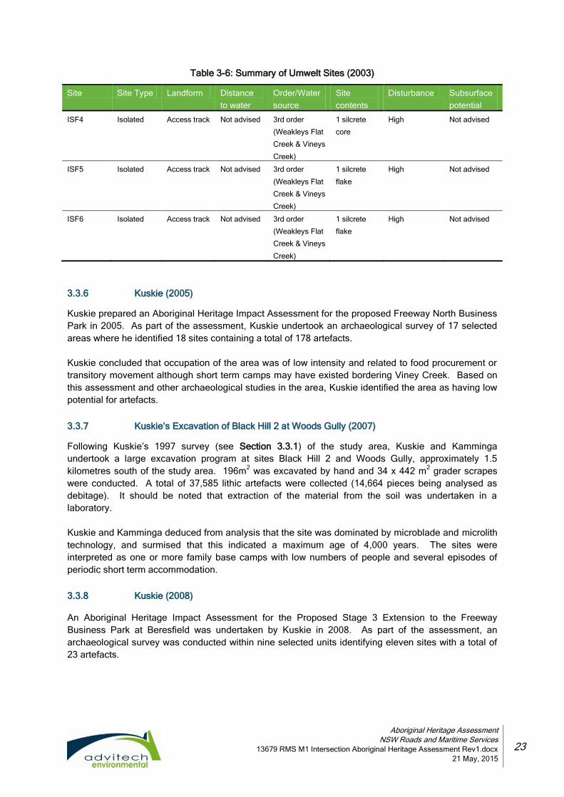
3.3.5 Umwelt (2003)
This was a supplementary archaeological study of the Aboriginal heritage values to a portion of the
Mining Lease Area (MLA) of the Donaldson Open Cut Coal Mine at Beresfield. Donaldson Projects Pty
Ltd was the proprietor of the MLA and the development project. The study area was confined to an
area identified as the Mine Impact Area (MIA) and any adjoining areas that were potentially related to
heritage values within the MLA. Previously archaeological investigation of the entire MLA had been
undertaken by Umwelt (Australia) Pty Limited (1988); however, in the Commission of Inquiry for the
Proposed Donaldson Open Cut Coal Mine, specific concerns were raised about the level of survey of
the MIA and commissioned a further archaeological investigation and assessment of this area. This
survey predicted the following model:
based on ethnographic evidence, the Aboriginal population of the Hunter area was “large
and relatively stable with a complex range of economic and social activities” (Umwelt
2003:4). Evidence left is limited due to the nature of materials used, such as wood which
decomposes over a relatively short period of time, and European disturbances;
stone artefact sites are the most commonly recorded sites in the Lower Hunter. These are
mostly small with silcrete being the most common raw material;
few sites have been recorded on slopes or crest remote from creek banks or the terraces of
swamps;
there a low frequency of scarred trees or grinding grooves;
recorded sites on slopes usually contain <20 artefacts and most commonly <5 artefacts; and
on wetlands, creek banks or margins and terraces a subsurface test pit investigation should
complement a surface survey.
The survey identified 3 isolated artefacts, as summarised in Table 3-6.
Sites NPWS #38-4-0339, ISF1, ISF2 and WFC1 were not relocated and were considered destroyed.
Subject to satisfaction of certain requirements, the archaeological assessment confirmed the results of
this survey were consistent with the predictions raised in the earlier archaeological assessment. The
survey revealed no sites of archaeological significance or contained any PAD’s.
Aboriginal Heritage Assessment
NSW Roads and Maritime Services
13679 RMS M1 Intersection Aboriginal Heritage Assessment Rev1.docx
21 May, 2015
23
Table 3-6: Summary of Umwelt Sites (2003)
Site Site Type Landform Distance
to water
Order/Water
source
Site
contents
Disturbance Subsurface
potential
ISF4 Isolated Access track Not advised 3rd order
(Weakleys Flat
Creek & Vineys
Creek)
1 silcrete
core
High Not advised
ISF5 Isolated Access track Not advised 3rd order
(Weakleys Flat
Creek & Vineys
Creek)
1 silcrete
flake
High Not advised
ISF6 Isolated Access track Not advised 3rd order
(Weakleys Flat
Creek & Vineys
Creek)
1 silcrete
flake
High Not advised
3.3.6 Kuskie (2005)
Kuskie prepared an Aboriginal Heritage Impact Assessment for the proposed Freeway North Business
Park in 2005. As part of the assessment, Kuskie undertook an archaeological survey of 17 selected
areas where he identified 18 sites containing a total of 178 artefacts.
Kuskie concluded that occupation of the area was of low intensity and related to food procurement or
transitory movement although short term camps may have existed bordering Viney Creek. Based on
this assessment and other archaeological studies in the area, Kuskie identified the area as having low
potential for artefacts.
3.3.7 Kuskie’s Excavation of Black Hill 2 at Woods Gully (2007)
Following Kuskie’s 1997 survey (see Section 3.3.1) of the study area, Kuskie and Kamminga
undertook a large excavation program at sites Black Hill 2 and Woods Gully, approximately 1.5
kilometres south of the study area. 196m2 was excavated by hand and 34 x 442 m
2 grader scrapes
were conducted. A total of 37,585 lithic artefacts were collected (14,664 pieces being analysed as
debitage). It should be noted that extraction of the material from the soil was undertaken in a
laboratory.
Kuskie and Kamminga deduced from analysis that the site was dominated by microblade and microlith
technology, and surmised that this indicated a maximum age of 4,000 years. The sites were
interpreted as one or more family base camps with low numbers of people and several episodes of
periodic short term accommodation.
3.3.8 Kuskie (2008)
An Aboriginal Heritage Impact Assessment for the Proposed Stage 3 Extension to the Freeway
Business Park at Beresfield was undertaken by Kuskie in 2008. As part of the assessment, an
archaeological survey was conducted within nine selected units identifying eleven sites with a total of
23 artefacts.

Aboriginal Heritage Assessment
NSW Roads and Maritime Services
13679 RMS M1 Intersection Aboriginal Heritage Assessment Rev1.docx
21 May, 2015
24
Table 3-7: Summary of Kuskie Sites (2008)
Site Site Type Landform Distance to
water
Order/Water
source
Site
contents
Disturbance Subsurface
potential
NWPS #38-4-0901 Weakleys 1/A
Isolated Small elevated spur
Not advised 3rd order (Weakleys Flat Creek & Vineys Creek)
1 silcrete core
High Nil
NWPS #38-4-0902 Weakleys 1/B
Artefact scatter
Gently elevated spur
Not advised “ “
2 silcrete flakes
High Nil
NWPS #38-4-0905 Weakleys 2/A NWPS #38-4-0906 Weakleys 4/A NWPS #38-4-0907 Weakleys 4/B NWPS #38-4-0908 Weakleys 4/C NWPS #38-4-0909 Weakleys 7/A NWPS #38-4-621 Donaldson Monitoring Site
Artefact scatter Isolated Isolated Isolated Isolated Isolated
Spur crest Gentle simple slope Mid to upper slope Gentle mid slope Gentle spur crest Gentle elevated spur
Not advised Not advised Not advised Not advised Not advised Not advised
“ “ “ “ “ “ “ “ “ “ “ “
3 silcrete flakes 1 tuff flake 1 silcrete core 1 silcrete core 1 silcrete flake 1 silcrete flake 1 silcrete flake 1 silcrete flake
High High High High High High
Nil Nil Nil Nil Nil Nil
Kuskie concluded that occupation of the area was widespread of low intensity and related to food
procurement or transitory movement although short term camps may have existed on the basal flats
and slopes bordering Viney Creek, Weakleys Flat Creek and Scotch Dairy Creek. Based on this
assessment and other archaeological studies in the area, Kuskie identified the area as having low
potential for artefacts.
3.3.9 ERM (2010)
ERM (2010) undertook an investigation for the Stage 2 upgrade and replacement of a section of the
Chichester Trunk Gravity Main near Beresfield. The study area was located along John Renshaw
Drive to the northern termination of the Sydney to Newcastle freeway (previously F3 now M1). The
study area was approximately 30 metres wide and 3.6 kilometres in length and included the 1923
water pipeline, an unsealed vehicle access track and a transmission line crossed the central portion of
the study area. The Beresfield area is characterised by low, undulating hills and abuts lowlands
associated with swamps and floodplains of the Hunter Valley.
The landscape contained low rises and slopes with an open depression containing the primary
waterways. The study area is located on the periphery of a network of high order streams and large

Aboriginal Heritage Assessment
NSW Roads and Maritime Services
13679 RMS M1 Intersection Aboriginal Heritage Assessment Rev1.docx
21 May, 2015
25
swamps with the main waterways being two third order creeks, Weakleys Flat Creek, which drains in a
northerly direction into Woodberry Swamp, and Viney Creek which drains in a northerly direction into
Weakleys Creek. Other smaller first order tributaries drained from the south west portion of the study
area into Hexham Wetlands. An unnamed area of swamp exists along the route of the study area.
Three major wetland systems are located close to the study area: Hexham Wetlands, located 1 km to
the south, Tarro swamp located 1.5km to the northeast and Woodberry swamp, 1.5km to the north
were a major source of Aboriginal resource exploitation. Vegetation within the study area comprised
medium to heavy density ironbark forest. Native vegetation had been stripped in areas such as
transmission easements, vehicle access tracks and for agricultural practices. Vegetation to the west of
the F3 (M1) was noted to be regrowth, and can be linked to historic timber-getting projects in
association with mining.
A search of the AHIMS database showed a total of 35 recorded sites within a 4 x 3 kilometre study
area; 21 artefact scatters, 14 isolated finds, and 1 PAD. It was noted that there appeared to be a
strong association between site location and nearby water sources and swamp margins. Two
previously recorded sites (one artefact scatter and one isolated find) were located within the study
area. Based on previous archaeological investigations, a predictive model was developed and stated
that artefact sites (scatters and isolated finds) are the most likely site type to be encountered in the
study area, and can be found on any landform (though crests and mid-low slopes seem preferred
The survey revealed that visibility was limited by ground cover, reducing the effective coverage, which
was 25% along one transect, but varied between 56% and 90% in all others. Five sites were identified
and are summarised in Table 3-8.
Table 3-8: Summary of ERM Sites (2010)
Site Site Type Landform Distance to
water
Order/Water
source
Site
contents
Disturbance Subsurface
potential
WP-IF-1 Isolated Crest and
slope
Not advised Not advised 1 artefact Low High
WP-IF-3 Isolated Slope Not advised Not advised 1 artefact Low High
WP-IF-4 Isolated Slope Not advised Not advised 1 artefact Low High
WP-AS-1 Artefact
scatter
Slope 0-50m Swamplands 3 artefacts Low High
WP-AS-2 Artefact
scatter
Slope Not advised Not advised 15 artefacts Moderate Low
A total of 21 artefacts were identified. The dominant raw material was silcrete followed by tuff. ERM
concluded that the sites identified conformed to the predictive model. The scientific significance of the
isolated find sites and WP-AS-2 were assessed as low, whereas WP-AS-1 was assessed as moderate
scientific significance due to its higher integrity. One previously recorded site, 38-4-0486 was
relocated during the survey and similarly assessed as being of moderate significance with high
potential. It was recommended that no further action was required with regards to the sites assessed
as low scientific significance other than collection of the artefacts. With the sites assessed as being of
moderate scientific significance, it was recommended that as they would be impacted by the proposed
works, test excavations would be required.

Aboriginal Heritage Assessment
NSW Roads and Maritime Services
13679 RMS M1 Intersection Aboriginal Heritage Assessment Rev1.docx
21 May, 2015
26
3.3.10 RPS Section 90 Application (2011a)
RPS (2011) prepared supporting information for an AHIP Section 90 application over the Freeway
South Business Park at Beresfield on behalf of Hunter Land Pty Ltd. Previously a Section 87 AHIP
had been issued for the majority of the project area. The addition of drainage lines and associated
infrastructure required the application of a new AHIP permit for the whole area.
The study area was fully contained within Lot 225 DP 1054242 and on John Renshaw Drive,
Beresfield with a total area of 40.2 hectares. The application was reliant on previous archaeological
investigations by Kuskie (2004, 2007, 2008) and in regard to the development and construction of
roads firstly with commercial buildings and warehouse to be eventually constructed.
The property had previously been impacted by vegetation clearance, construction of electricity
easements, maintenance tracks, motorcycle tracks and the dumping of rubbish by the public. The site
was considered moderately to be highly disturbed. 17.4 hectares was to be dedicated for use as open
space and conservation areas in order to mitigate the impacts and losses caused by the development
of the remaining 22.8 hectares.
The AHIP methodology was proposed as follows:
monitoring along the proposed roadway;
monitoring in proposed sewer line corridors and associated drainage and filter areas to
topsoil level only; and
salvage and collection of exposed artefacts and stockpiles during clearance works.
Appendix 2 to this report was the RPS (2011b) Aboriginal Cultural Heritage Salvage and Excavation
Report supporting the previously issued S.87 AHIP (NPWS#3144/#1102287).
3.3.11 RPS (2011b)
RPS (2011b) is the Aboriginal Cultural Heritage Salvage and Excavation Report accompanying the
RPS (2011a) AHIP application over Freeway South Business Park. This report is the documentation
resulting from the field work and analysis arising from the collection and salvage of artefacts under
NWPS Section 87 permit (NPWS#3144/#1102287). The sites involved were those previously
identified in Kuskie (2008) and Table 3-9 reflects the artefacts found after analysis had taken place. It
should be noted that the soil was examined in a laboratory and artefacts removed from all soil.

Aboriginal Heritage Assessment
NSW Roads and Maritime Services
13679 RMS M1 Intersection Aboriginal Heritage Assessment Rev1.docx
21 May, 2015
27
Table 1: Summary of RPS Sites (2011b)
Site Site Type Landform Distance to
water
Order/Water
source
Site
contents
Disturbance Subsurface
potential
NWPS #38-4-0901 Weakleys 1/A
Isolated Small elevated spur
Not advised
3rd order (Weakleys Flat Creek & Vineys Creek)
3 artefacts High Nil
NWPS #38-4-0902 Weakleys 1/B
Artefact scatter
Gently elevated spur
Not advised
“ “
4 artefacts High Nil
NWPS #38-4-0905 Weakleys 2/A NWPS #38-4-0906 Weakleys 4/A NWPS #38-4-0907 Weakleys 4/B NWPS #38-4-0908 Weakleys 4/C NWPS #38-4-0909 Weakleys 7/A NWPS #38-4-621 Donaldson Monitoring Site 2
Artefact scatter Isolated Isolated Isolated Isolated Isolated
Spur crest Gentle simple slope Mid to upper slope Gentle mid slope Gentle spur crest Gentle elevated spur
Not advised Not advised Not advised Not advised Not advised Not advised
“ “ “ “ “ “ “ “ “ “ “ “
57 artefact Nil 1 artefact Nil Nil 1 artefact
High High High High High High
Nil Nil Nil Nil Nil Nil
It was concluded that the study area was similar to Woods Gully (Kuskie 2007) in regard to occupation
intensity and frequency which suggested that the nature of occupation, as pertains to distance from
Hexham Swamp, occurred at intervals of 500m and 2 km. The results also revealed a difference in the
proportion of raw materials at each of the sites suggesting a greater variety in stone tools at Woods
Gully than at Freeway South.
3.3.12 MCH (2012)
MCH (2012) undertook an Aboriginal Heritage Impact Assessment (AHIA) for the proposed Hexham
Train Support Facility (TSF) along Woodlands Close, Hexham. The study area is located on the
western side of the Pacific Highway at Hexham and includes 255 hectares of land zoned for industrial,
special uses and environmental. The site was bounded by the Pacific Highway and the New England
Highway to the north and east and by rural and environmental lands to the south and west, including
Hexham Swamp Nature Reserve. The study area consisted of low lying flats (part of the Hunter River
floodplain) that are constantly water logged in the north and a highly disturbed landscape in the south.
A search of the OEH AHIMS register revealed that 93 known Aboriginal sites were currently recorded
within a ten kilometre radius of the study area including 51 open camps, 25 artefact sites, 6 isolated
finds, 3 grinding grooves, 3 artefact/PADs, 3 PADs, one scarred tree and one artefact/PAD/grinding
groove site. Previous assessments within a similar environmental context indicated that, within a well-
watered context, there is high potential for archaeological material to be present on level, typically well-
elevated landforms that provide ready access to low lying waterlogged areas and the associated

Aboriginal Heritage Assessment
NSW Roads and Maritime Services
13679 RMS M1 Intersection Aboriginal Heritage Assessment Rev1.docx
21 May, 2015
28
resources. The majority of sites within the area appear to contain low-moderate artefact densities
situated on elevated landforms.
The northern portion of the study area had been subject to European land uses and impacts and the
southern portion of the study area was highly disturbed through past land uses and it was expected
that all cultural materials that may have been present would no longer exist.
Vegetation during the assessment was dense with overall effective coverage being 1% and grass
being the limiting factor with minimal erosion along the drainage line and exposures from cattle. No
sites were identified during the survey. This was attributed to the geomorphic history rendering the
area unsuitable for camping, poor visibility, disturbances and the low lying flood prone landform that
may not have been suitable for occupation. While the study area may have been utilised for hunting
and gathering, resulting in reduced evidence of occupation, the disturbances in the northern portion
would have disturbed that evidence. The disturbances in the southern section would have destroyed
any such evidence. No sites were identified within Hexham swamp itself.
3.3.13 RPS (2012)
RPS conducted an investigation of land at Thornton for the purposes of rezoning for the Glenwood
Business Park. The study area was divided by Weakleys Drive and Glenwood Drive to the north east
of the New England Highway. An AHIMS search disclosed one previously recorded site, an artefact
scatter, on the boundary of the study area.
The study area was mainly open grassland with several dams and waterways connected to Woodberry
Swamp. The field survey focused on areas of elevation above the swamp areas and ground surfaces
with exposure. Mature trees were also inspected. The survey disclosed disturbance had occurred
including vegetation clearance, laying and maintenance of lawns, rubbish dumping, fill, roadworks and
associated infrastructure. The investigation identified no archaeological items within the study area.
The previously registered site was not relocated. A scarred tree was recorded outside of the study
area to ensure that no ancillary impact occurred.
3.4 Summary of the archaeological context
In order to form a contextual base for the current assessment and a predictive model of the study area,
a review of the regional and local archaeological investigations together with registered sites within
1000 metres provides a broader picture of the wider cultural landscape. By highlighting the range of
Aboriginal sites throughout the region and the locality, and also taking into account the environment of
the study area, an archaeological predictive model can be established. However, it must be
remembered that there are various factors which will affect the results. These include but are not
limited to:
the landform on which a site area is observed is not necessarily its original context, for
example, artefacts which would have originated on a crest may be located down the slope
due to erosion and slip;
biases due to differential sampling of landforms based on decisions made by archaeologists;
levels of exposure on different landforms, and the variable level of reporting by
archaeologists;
variations between archaeologists’ classifications of raw material types and analysis of
stone artefacts (for example tuff and indurated mudstone). For example, the distinction
between a waste flake, a debitage flake and a flaked piece may be heavily subject to the

Aboriginal Heritage Assessment
NSW Roads and Maritime Services
13679 RMS M1 Intersection Aboriginal Heritage Assessment Rev1.docx
21 May, 2015
29
perspective of the recorder. Raw material type was not indicated in many of the reports and,
as such, only general comments are made as it would not be productive to attempt to
quantify the proportionate representation of artefact types identified in previous studies; and
artefact counts can be skewed due to factors such as differing levels of fragmentation of
material and levels of ground surface visibility. A very large number of sites/artefacts were
located on exposures with either no or very few artefacts visible away from the exposures.
Therefore these results provide merely an indication of what may be expected in terms of site location,
content and distribution.
3.4.1 Regional archaeological context
The majority of archaeological surveys and excavations throughout the region have been undertaken
in relation to environmental assessments for industry and commercially related developments. Based
on the available information, it is possible to identify a number of trends:
artefact scatters and isolated finds are by far the most common site types. It should be
noted isolated finds are also referred to as open campsites or artefact scatters;
a variety of other site types have been identified in the region in far lower concentrations and
include grinding grooves, scarred trees, rock shelters, shelters with art and burials. A high
representation of sites containing stone artefacts is to be expected due to the durability of
stone in comparison to other raw materials such as wood;
mudstone is the most common lithic material found in the region, followed by silcrete. Chert,
tuff, quartz, quartzite, petrified wood, porcellanite, hornfels, porphyry, basalt, limestone,
sandstone, rhyolite, basalt, European glass and other non-specific lithic types also occur in
smaller quantities;
the majority of Aboriginal open sites within the region are attributed to the Holocene period;
McCardle (2012), in assessing sites in terms of distance to water, suggests that there is a bi-
modal distribution of sites and their relativity to water. McCardle (2012) states that the
majority of sites are situated within 50 metres of water and the next highest proportion of
sites are over 100 metres from water, with comparatively few sites present in the zone 50-
100 metres from water. This bimodal pattern is echoed in relation to site size. The bulk of
large and medium sites are situated within 50 metres of water, dropping in representation in
the area 50-100 metres from water before reaching another lesser peak at distances over
100 metres from water;
the majority of sites within 50 metres of water are present on creek lines whilst slopes and
crest/ridge formations are also common site locations. The frequent presence of sites on
crest/ridges and slopes is also noticeable for sites located over 50 metres from water;
grinding groove sites are located within 50 metres of water;
closed camping sites (such as a rockshelter), petroglyphs and scarred trees do not appear
to have any recognisable pattern, other than the necessary presence of overhangs and
outcrops, and only a small amount of these sites have been recorded; and
the majority of artefacts are observed on exposures with good to excellent ground surface
visibility. The site area is often given as the area of exposure. It is therefore difficult to
attempt to draw any conclusions regarding site extent based on current information.

Aboriginal Heritage Assessment
NSW Roads and Maritime Services
13679 RMS M1 Intersection Aboriginal Heritage Assessment Rev1.docx
21 May, 2015
30
3.4.2 Local and regional character of Aboriginal land use and its material traces
The regional character and patterning of Aboriginal land use and material traces are also generally
reflected on a local basis. Within the local area, previous assessments within a similar environmental
context indicate that, within a well watered context, there is high potential for archaeological material to
be present on level, typically well elevated landforms that provide ready access to low lying
waterlogged areas and the associated resources.
The majority of sites within the area appear to contain low to moderate artefact densities with open
campsites and isolated artefacts being the most common site types. Lithic artefacts are primarily
manufactured from mudstone and silcrete with a variety of other raw materials (tuff, quartz, chert, and
so on) also utilised but in lesser proportions. Site numbers and artefact volumes are greatest within
close proximity to water such as creek lines, crests or ridges and slopes are the most archaeologically
sensitive landforms.
Previous archaeological studies within 1000 metres of the study all basically concluded that
occupation of the subject area was widespread, of low intensity and has low potential for artefacts. Its
use related to food procurement or transitory movement. Short term camps may have existed within
50 to 100 metres of the basal flats and slopes bordering Viney Creek and Weakleys Flat Creek. Based
on information gained from previous studies within a 1000 metre radius of the study area, it can be
expected that:
the likelihood of locating sites increases with proximity to water;
the likelihood of finding large sites increases markedly with proximity to water;
in swamp areas, sites are more likely to be found on the elevated margins of the swamp;
the majority of sites more than 50 metres from a watercourse may contain less than 10
visible artefacts;
large artefact scatters can occur more than 50 metres from a watercourse but infrequently;
a variety of raw materials will be represented though the majority of sites will be
predominated by mudstone and silcrete;
a variety of artefact types will be located though the majority will be flakes, flaked pieces and
debitage;
grinding grooves will be located along or near water sources;
the likelihood of finding scarred trees is dependent on the level of clearing in an area;
the majority of sites will be subject to disturbances including human and natural; and
the majority of sites contain stone artefacts which is to be expected due to stone’s high
preservation qualities.

Aboriginal Heritage Assessment
NSW Roads and Maritime Services
13679 RMS M1 Intersection Aboriginal Heritage Assessment Rev1.docx
21 May, 2015
31
4. LANDSCAPE CONTEXT
The nature and distribution of Aboriginal cultural materials in a landscape are influenced by the
availability of plants, animals, water, raw materials, the location of suitable camping places, ceremonial
grounds, burials, and suitable surfaces for the application of rock art or petroglyphs. Environmental
factors such as topography, geology, landforms, climate, geomorphology, hydrology and the
associated soils and vegetation determine the availability of these resources and influence the degree
to which cultural materials have survived.
Both natural and human influences affect the likelihood of sites being detected during ground surface
survey. Site detection is dependent on a number of environmental factors including surface visibility
(which is determined by the nature and extent of ground cover including grass and leaf litter, and so
on) and the survival of the original land surface and associated cultural materials (by flood alluvium
and slope wash materials). It is also dependant on the exposure of the original landscape and
associated cultural materials (by water, sheet and gully erosion, ploughing, vehicle tracks, and so on)
(Hughes and Sullivan 1984). Combined, these processes and activities are used in determining the
likelihood of both surface and subsurface cultural materials surviving and being detected.
It is therefore necessary to investigate the natural, human and environmental factors, processes and
activities that may affect site location, preservation, and detection during surface survey and the
likelihood of in situ subsurface cultural materials being present. These factors, processes and
disturbances of the surrounding environment and the specific study area are discussed below.
4.1 Topography
The topographical context of the study area is an important tool in identifying factors relating to past
Aboriginal land use patterns. The specific study area is situated within the East Maitland Hills
physiographic region of the Port Stephens Sheet (Matthei, 1995:2). This area consists mainly of
undulating low hills and rises with broad crests, long and gently inclined sideslopes. Drainage lines
are deeply incised and narrow with rock outcropping generally absent. The original topography of the
study area has largely been destroyed by the construction of the M1.
4.2 Geology
The geological structure of the Newcastle region is complex and varied. The Hunter Fault, a zone of
thrusting faults trending in a north westerly direction which passes beneath the deep Quaternary
sediments of the coastal plain, is one of the most important aspects of Newcastle’s geology. The
Hunter Fault is the boundary between the Permian sediments of the Sydney Basin and Carboniferous
system that outcrops to the north east.
The geology of the region surrounding the study area is not only reflected in the environment
(landforms, topography, geomorphology, vegetation, climate, and so on), but also indicates areas
suitable for past occupation and its manifestation in the archaeological record. The nature of the
surrounding and local geology along with the availability and distribution of geological resources,
particularly stone materials, has a number of implications for Aboriginal land use and its archaeology.
The study area is situated on folded Permian rocks that consist of shales, tuffs, sandstone, mudstones,
and coal, with some lava beds in the basal portion, and contain the extensive coal measures that are
mined throughout the region. Generally, the Permian rocks are only moderately resistant,
consequently forming the lowlands (Newcastle Geological Map 1966).

Aboriginal Heritage Assessment
NSW Roads and Maritime Services
13679 RMS M1 Intersection Aboriginal Heritage Assessment Rev1.docx
21 May, 2015
32
Materials most dominant in stone tool manufacture are indurated mudstone or tuff and silcrete, and are
commonly found in creek line deposits, such as those observed at Black Hill and Woods Gully (Kuskie
and Kamminga 2000:183). No raw materials suitable for stone tool manufacture are located within the
study area.
4.3 Geomorphology
The geomorphological evolution of the Newcastle region is complex and there are two major periods
that significantly changed the landscape for past Aboriginal occupation of the area. The relevant
period of environmental history for Aboriginal occupation is within the last 50,000 years with the critical
time being the last 20,000. At the last glacial maximum (20,000 ya), the sea level was about 120
metres lower than present. Sea levels then rose rapidly from about 17,000 ya until 10,000 ya, with sea
level rates tapering until the present level that was reached at 6,000 ya. The nearby Hunter River
Estuary is typical of the larger NSW estuaries that have evolved over the millennia through various
geological developments, climatic periods and sea level variations to the present day. The present
day estuary is a drowned river valley with an extensive floodplain delta where the river meanders to
the sea. At the height of the Last Glacial period, sea level was at minus 120 metres AHD (Australian
Height Datum), and the shoreline was about 30 kilometres seaward of its present position.
Importantly, towards the end the Last Glacial period, it is likely that the study area was part of, or
adjoined an open bay (now known as Hexham Swamp) which was dominated by marine processes
and tidal delta deposition. In summary, the study area was most likely favourable for occupation due
to its elevation and nearness to the Hexham Swamp and its resources.
4.4 Soils
The study area is within the Beresfield soil landscape which contains the underlying Permian Tomago
Coal Measures (shale, mudstone, sandstone, coal, tuff and clay), Permian Mulbring Siltstone
(siltstone, claystone, thin sandstone and limestone) and Permian Waratah Subgroup (Matthei, 1995:3).
The locality of the study site lies within the Sydney Basin geological region, and is characteristic of the
‘Beresfield (Be)’ and ‘Cockle Creek (Cc)’ soil landscapes. Soils within the study area consist of
moderately deep, moderately well to imperfectly drained Yellow Podzolic and Brown Podzolic Soils
(sandy loam A Horizon with heavy clay B and C Horizons), with brown Soloths occurring on the crests.
The soils are generally slightly to moderately acidic and moderately to highly reactive (Matthei, 1995).
The Newcastle Local Environmental Plan (2012) Acid Sulfate Soils Map indicates that the site is
generally classified as ‘Class 5’, which is considered to have the lowest probability of containing ASS.
4.5 Hydrology
One of the major environmental factors influencing human behaviour is the availability of water and, as
such, people will not travel far from reliable water sources unless necessity dictates, such as travelling
to obtain rare or prized resources and or trade. Proximity to water not only influences the number of
sites likely to be found, but also artefact densities. The highest number of sites and the highest density
are usually found in close proximity to water and usually on an elevated landform. Regional
archaeological investigations support this modelling with open camp sites typically being within
50 metres of a reliable water source. The main types of water sources include permanent (rivers and
soaks), semi-permanent (large streams, swamps and billabongs), ephemeral (small stream and
creeks) and underground (artesian).

Aboriginal Heritage Assessment
NSW Roads and Maritime Services
13679 RMS M1 Intersection Aboriginal Heritage Assessment Rev1.docx
21 May, 2015
33
When assessing the relationship between sites and water sources, it must be noted that the Australian
continent has undergone significant environmental changes during the past 45,000 to 60,000 years
(being the current and widely varying estimated period that people have lived here), and that
Pleistocene sites (older than 10,000 years) would have been located in relation to Pleistocene water
sources that may not exist today. The modern landscape experiences seasonal waterlogging, high
localised run on and water erosion hazard (Matthei, 1995). Urbanisation of the Hunter Water
catchment has permitted major irreversible impacts on the hydrology of the area. Land clearing
reduces the opportunity for local ponding of surface water and the installation of gutters, pipes and
concrete channels also contributes to hydrological change. Compared with the run off from a forested
catchment (2%), the percentage of runoff from an urban catchment may be as high as 98-100%.
Natural surface hydrology in the study area is limited (Newcastle Catchment Characteristics, 2004).
One unnamed first order stream is located in the north east quadrant of the study area, and a third
order stream, Viney Creek extends under John Renshaw Drive approximately 650 metres from the
intersection between John Renshaw Drive and the M1 Pacific Motorway, at the western extent of the
study site. A constructed drainage line (concrete catch drain) extends along the western side of the
M1 Pacific Motorway. The catch drain passes through a culvert approximately 250 metres south of the
intersection between the Motorway and John Renshaw Drive, and terminates at a constructed
sedimentation dam on the eastern side of the M1 Pacific Motorway. Three major wetland systems are
located close to the study area: Hexham Wetlands, Tarro swamp and Woodberry swamp. Viney
Creek and these wetland systems would have been a major source of resources for the Aboriginal
occupants of the locality.
4.6 Landforms
As site locations may differ between landforms due to environmental constraints that result in the
physical manifestation of different spatial distributions and forms of archaeological evidence,
landforms are used in constructing predictive models of Aboriginal site locations.
Generally, the location of the study area has a natural topography of undulating low hills and rises, with
a local relief of 10 to 50 metres and natural drainage lines. In the north east of the site, narrow flood
plains with deeply incised drainage lines lead towards the extensive alluvial floodplain of the Lower
Hunter River (Matthei, 1995). See Section 5.2 for specific landforms and diagrams.
4.7 Landscape history, uses and disturbances
Based upon archaeological evidence, the occupation of Australia extends back over 40,000 years
(Hiscock 2008), whilst Aboriginal people have been present within the Hunter Valley for at least 20,000
years (Koettig 1986). It is generally considered that the impact of past Aboriginal occupation on the
natural landscape is thought to have been relatively minimal; however, it should not be simply
assumed that over 20,000 years of land use could have passed without affecting various
environmental variables. Other than the practice of seasonal burning off and the setting of stone
fishtraps within waterways, very little is known about the effects of Aboriginal occupation on the
landscape.
Burnham Burnham (1988:58) described the Awabakal manufacturing canoes using local trees, bark
and stones as anchors. Flowers and bark were used to make flax from which twine, nets and work
bags were made. The making of fish hooks, the preparation of glue for spears, rope and cord making,
hunting and food preparation all took place using items available in the nearby landscape or
sometimes traded from other groups (Bonhomme 1996:7; McBryde 1974:13). The landscape also
provided the most important resources of water and food. Fresh water would have been available at

Aboriginal Heritage Assessment
NSW Roads and Maritime Services
13679 RMS M1 Intersection Aboriginal Heritage Assessment Rev1.docx
21 May, 2015
34
Viney Creek during most, if not all, of the year. Aboriginal people were highly skilled and proficient
hunters and gatherers in tune with the cycles and seasonal changes of their surrounding environment.
Thousands of years of occupation and inherited knowledge was used by Aboriginal people to
determine the best way and the right time to hunt and gather for the flora, fauna and marine delicacies
it contained.
Following European settlement of the area in the 1820s, the landscape was subjected to a range of
disturbances including extensive clearing, agricultural cultivation, pastoral grazing, residential
developments and mining. The more recent construction of the M1 freeway and its associated
infrastructure, particularly drainage, has left vegetation within the investigation area virtually non-
existent. Drainage ditches have been constructed at the boundary of the road surface and the
adjoining bushland. Vegetation remaining in the investigation area is very sparse with insignificant
ground cover if any at all. The spraying of shotcrete over both horizontal and vertical surfaces in and
at varying levels has prevented regrowth of vegetation. The bushland within and immediately
adjoining the investigation area (to the west and south) is primarily covered with a sparse scattering of
native trees and the ground cover consists of small bushes, shrubs, ferns, saplings and leaf litter.
No sites were identified during the survey. This may be due to a number of reasons including the
geomorphic history and landforms rendering the area less favourable for occupation than other nearby
more suitable locations, such as elevated landforms closer to the nearby Viney Creek. Other factors
affecting the location of sites may include poor visibility and disturbances. While the study area may
have been utilised for hunting and gathering, resulting in reduced evidence of occupation, the
construction of roadways and their related infrastructure would have extensively disturbed or
destroyed that evidence.
The landscape in the immediately vicinity of the study location has been extensively modified to allow
for roads, industrial developments, underground services and supporting infrastructure. Drainage lines
have been constructed and formed in concrete and with stone on either side of the M1 and Weakleys
Drive. Undulations are generally absent or gently sloping, with no steep gradients due to clearance
and development.
The disturbance of cultural materials can also result from natural processes. Both deposition and
erosion within a locality can influence the formation and or destruction of archaeological sites.
Moderate sheet erosion often occurs where whole scale vegetation clearance has taken place.
Deposition, alongside minimal to moderate erosion, of the landscape will bury cultural materials and,
over an extended period, repeated deposition will result in the compression of the archaeological
record with multiple occupational episodes being located on one surface prior to burial. If erosion
occurs after cultural material is deposited, it will disturb or destroy sections of archaeological sites.
The more frequent and severe the episodes of erosional events the more likely it is that the
archaeological record in that area will be disturbed or destroyed (Waters and Kuehn, 1996:484).
The role of animal and insect bioturbation is another significant factor in the disturbance of the
archaeological record within a landscape. Post-depositional processes can disturb and destroy
artefacts and sites as well as preserve cultural materials. Burrowing and mounding animals (such as
earthworms, curl grubs and ants) redistribute and mix cultural deposits. Tree root growth and tree falls
can also disturb the insitu state of artefacts, in that artefacts can move downwards through root holes
as well as through sorting and settling due to gravity. Artefacts may also be moved as a result of an
oscillating water table causing alternate drying and wetting of sediments, and by percolating rainwater.

Aboriginal Heritage Assessment
NSW Roads and Maritime Services
13679 RMS M1 Intersection Aboriginal Heritage Assessment Rev1.docx
21 May, 2015
35
4.8 Resources
Previous Palaeolithic studies have identified that the hunter gatherer activities of Aboriginal peoples
related to movements which were ‘embedded’ within a certain region (Wobst, 1983:22). The
availability of flora and fauna combined with fresh water sources affected the resources in a given
location which, in turn, influenced patterns of past Aboriginal land use and occupation. The availability
of flora and fauna would have affected the range of resources available for food, medicine and the
manufacture of objects such as fishing nets, string bags, shields, canoes, fur coats and protection from
the weather or climate. An article in the Wallsend & Plattsburg Sun in 1890 (17/12) notes:
“The principle animal food of the Aboriginal was the possum, wallaby, and Kangaroo rat. The
kangaroo, emu, and the hundred and one other animals that ranged the hills and scrub were
also acceptable, but the possum was really the animal he relied most upon. The possum was
always abundant and easily procured…[by the setting of snares]…Besides snares, fire was
employed in getting at possums and other animals, and the natives were very clever in
smoking their victim out and capturing it when about to make its escape. Different tactics were
adopted in the capture of different animals. The kangaroo, wallaby, and larger animals were
generally hunted with spears…Everything that came in the way of the [aboriginal person] was
eaten. There is hardly an animal, fish, reptile or insect that was not greedily devoured. Reptiles
were particular delicacies. The carpet snake afforded a splendid evening meal; the iguana was
another much sought after dish, while the lizards and various snakes always found a space in
the stomachs of hungry natives. The flesh of the reptile is beautifully white, and those
Europeans who have been compelled to eat with the natives declare that one could not tell the
flesh from eel; the carpet snake and iguana being especially good. Nothing delights the
[aboriginal people] more than to have a well stocked camp and while cooking operations are
going on it is something to remember the huge pile of possums, cats, snakes and lizards on
the hot embers”.
In 1825, Edward Sparke Snr received a grant which covered much of present day Beresfield and Tarro
(Hartley,1995:87). Following colonisation and during the 1800’s, the European settlers extensively
cleared the original native vegetation. However, drainage throughout the area would presumably have
supported a limited range of faunal populations including kangaroo, wallaby, goanna, snakes and a
variety of birds. A wider variety of resources would have been available in the three major wetland
systems located close to the study area: Hexham Wetlands to the east, Tarro swamp to the northeast
and Woodberry swamp to the north. These wetland systems would have been a major source of
Aboriginal resource exploitation. The nearby third order Viney Creek would have also have provided a
variety of resources and reliable freshwater.
4.9 Ethno-historical
The colonisation of Australia and its associated European settlement has unfortunately resulted in the
destruction of past Aboriginal communities, their culture, social structure, activities and beliefs. In the
study region, a minimal amount of information with regards to the Aboriginal traditional way of life prior
to colonisation is available. Anthropologists and ethnographers have attempted to piece together a
picture of past Aboriginal societies throughout the Hunter Valley but such information is often diluted
and confused by language barriers and personal interpretations. It is highly debateable in its veracity
as a result of European bias and interpretation. The limited ethno-historical records available reflect
the degree of interest and attitudes towards Aboriginal people which varied greatly and was highly
affected by colonisation’s violent settlement history, lack of understanding and fear of ‘the other’.

Aboriginal Heritage Assessment
NSW Roads and Maritime Services
13679 RMS M1 Intersection Aboriginal Heritage Assessment Rev1.docx
21 May, 2015
36
Cultural practices (such as initiation ceremonies and burial practices) were rarely viewed and, if such,
an opportunity was given and in fact recorded, the informant would then interpret what he saw based
on his own understanding and then generalise about those practices. The main sources of information
are the historical records of the colonial period, both official reports of exploration or administration,
and the unofficial records in the diaries, station journals and reminiscences of those who took up land
in the Hunter Valley.
The placing of tribal boundaries is another area complicated by European interpretation. A lack of
ability or understanding by non-Aboriginal people to see the land as Aboriginal people did, led to
confusion over tribal boundary areas. In 1861, J.D.Lang noted that Aboriginal people
“were universally divided into district and independent tribes, each occupying as their hunting
grounds a certain portion of territory, of which the limits are generally well defined by
permanent features in the natural scenery of the country, and well known to all the
neighbouring tribes….the territory of each tribe is subdivided… among the different families of
which it consists and that there was exclusive rights to direct when such a territory should be
hunted over, the grass burned for the obtaining of its animals for food…“.
He also came to the conclusion that, and due to the extensive time that Aboriginal people had
occupied the land, these repeated divisions and subdivisions as families changed over generations,
meant that virtually all people could claim was lineage or be rightful descendants of the rights
previously enjoyed by their forefathers, either patrilineal or matrilineal (Tindale, 1974:76-77).
The naming of places using Aboriginal names has also been widely misinterpreted. It is thought that
Aboriginal people had no written language, it was purely oral. However this is also a simplistic way of
interpreting the situation. Aboriginal people certainly used symbols such as petroglyphs, rock art, tree
marking and rock formations which, like the Ancient Egyptian hieroglyphics, was a visual language
(McDonald 2008).
It is considered that Aboriginal people have been present within the Hunter Valley for at least 20,000
years (Koettig 1987). Due to European settlement and the associated destruction of Aboriginal
resources, communities, culture, social structures, activities and beliefs, little information of the early
traditional Aboriginal way of life remains. The main sources of historical information are derived from
historical records of the colonial period, official reports of exploration or administration, unofficial
records in the diaries, station journals and reminiscences of those who settled in the Hunter Valley.
Historic documents indicate that the Pambalong (also known as Bambalong) Tribe occupied the
Hexham Swamp area (Gunson 1974:30). It is unclear whether the Pambalong were a subgroup of the
Awabakal Tribe or a group in their own right. It is also not certain whether the Pambalong occupied
the actual study area. Gunson (1974:30) states that the Awabakal were originally the largest clan of a
tribe in the Lake Macquarie region. This is supported by the Wonnarua people who claim the
Awabakal (Awaba-gal) were part of the Wonnarua language speaking group and a clan of their tribe. It
is suggested that the missionary Reverend Lancelot Edward Threlkeld (1788 - 1859), who created an
Aboriginal mission on the banks of Lake Macquarie in 1826, and his renderings was the cause of the
Awabakal name encompassing the whole tribe. Whatever the case, the most detailed historical
information regarding the early Awabakal people comes from Reverend Threlkeld. As part of his
missionary instruction, and while he was compiling a grammar and vocabulary of the Awabakal dialect,
he questioned the Aboriginal people about their language, beliefs and was given the opportunity to
witness some of their rituals. He recorded dreaming stories, important places, and ritualistic practices.
To this date, the considered original occupants of the area, the Awabakal retain links to their country
and the study area.

Aboriginal Heritage Assessment
NSW Roads and Maritime Services
13679 RMS M1 Intersection Aboriginal Heritage Assessment Rev1.docx
21 May, 2015
37
Trade between groups over some distances was considered to be a common place occurrence as
evidenced in Archaeological records by the finding of tools manufactured from raw materials not
available in the area. Attenbrow (2010:123) reports on oral history received from local residents of the
Newcastle region that a common trade and travelling route existed between Singleton and the east
coast regions. F D McCarthy also hypothesised that there was a trade route along the east coast from
Newcastle to Sydney and the Reverend Threkheld writes of a trading venture between Lake
Macquarie and ‘the mountains’ for the acquisition of opossum cord for ceremonial purposes (cf,
Attenbrow 2010:123).
4.10 Models of past aboriginal land use
One of the main aims of this project is to attempt to define both the nature and extent of Aboriginal
occupation and past land use within the study area in order to assess whether Aboriginal sites may be
present. In order to do this, a model of past Aboriginal land use based on a summary of both regional
and local archaeological investigations is compiled (see Section 3). Combining this summary of
archaeological investigations, the landscape context, registered sites and available resources in the
study area provides a model of past Aboriginal land use incorporating variations across the landscape,
landforms and assemblages that correspond with variation in the general patterns of landscape use
and occupation.
Advitech Environmental recognises that in attempting to devise a model of past Aboriginal land use we
lack the knowledge Aboriginal people had over their land. Geographical recognition by Aboriginal
people of their country involved a name for every place; usually on account of some peculiarity of the
physical feature or in recognition of an occurrence that took place there. Aboriginal people had an
intimate knowledge and name for every bend in the river, or of a place where an abundance of food
was to be found, or where good supplies of water, wood or stone were located (Canon Carlos Stretch
Collection, cf. University of Newcastle 2000).
Past Aboriginal land use of the study area is indicated as being complimentary activity that occurs
within the foraging radius of a home base camp (approximately 10 km) (Renfrew and Bahn 1991). On
the premise that these sites served as a focus of a specific activity, they will show a low diversity in
artefacts and are not likely to contain features reflecting a base camp (such as hearths). However, it is
also possible that the location of certain activities cannot be predicted or identified, adding to the
increased dispersal of cultural material across the landscape. If people were opting to carry stone
tools during hunting and gathering journeys throughout the area rather than manufacturing tools at
task locations, an increased number of used tools can be recovered from low density and dispersed
assemblages.
4.11 Predictive model
Due to issues surrounding the highly disturbed nature of the study area, ground surface visibility and
the fact that the distribution of surface archaeological material does not necessarily reflect that of sub-
surface deposits, it is considered essential to establish a predictive model. By combining the previous
archaeological studies undertaken throughout the region (see Section 3.3), the OEH AHIMS register
(see Section 3.1) and the landscape context (Section 4) a relatively good indication of site types and
site patterning can be predicated for the locality of study area. The following predictive model is
suggested:
Moderate potential for occupation sites (artefact scatters and isolated finds) on elevated
areas within 100 metres of the third order stream Viney Creek and the previous natural
drainage course;

Aboriginal Heritage Assessment
NSW Roads and Maritime Services
13679 RMS M1 Intersection Aboriginal Heritage Assessment Rev1.docx
21 May, 2015
38
High potential for occupation sites with higher artefact densities on elevated areas within fifty
metres of Vineys Creek or the natural drainage course;
Surface artefact scatters are generally low in numbers and density but should not be seen
as an indication of the numbers and density of any subsurface artefacts;
Subsurface artefacts are typically located in the topsoil and shallow ‘A’ horizons and are
particularly subject to post depositional processes;
Isolated finds may be encountered in any landform; and
Low potential for middens, quarry sites, scarred trees and stone arrangements to occur in
the study area.
This base predictive model is then refined taking into account landforms and the occurrence of modern
disturbances within the study area. The study area is located further than 100 metres from Viney
Creek and has been highly affected by the clearance and excavation works for the M1 and its
accompanying infrastructure. Natural drainage lines have been have been diverted and modernised
including the addition of a culvert from the east to west across survey unit 1. Given the highly
disturbed nature of the site, archaeological sites and the landscape context, nil to very limited evidence
of past occupation is expected to occur within the area. There is a very low to nil chance that isolated
finds and or very low density artefact scatters may be still be present within the study area.

Aboriginal Heritage Assessment
NSW Roads and Maritime Services
13679 RMS M1 Intersection Aboriginal Heritage Assessment Rev1.docx
21 May, 2015
39
5. ARCHAEOLOGICAL FIELD SURVEY
5.1 Methodology
The survey areas were surveyed in the late morning on 17 March, 2015, and on foot by Viki Gordon
(Advitech Environmental Archaeologist), James Sinclair (Mindaribba Local Aboriginal Land Council
representative), and RMS representatives Theo Stephanou (Project Manager) and Stephen Knight
(Aboriginal Cultural Heritage Officer). The survey included a single transect varying from one to three
metres apart depending on accessibility. The survey focused on those areas of exposure at the
extents of the existing roadways that would be impacted by the proposed works in order to identify any
artefactual evidence. All areas of the study area were transected, excluding the in-use road surfaces.
5.2 Landforms
Due to the highly altered and disturbed nature of the limited study area, no landforms were considered
to have original surface areas, as evidenced by alteration of the topography, the vegetation clearance
and immature regrowth. Due to the relative consistency of the landforms in the survey area, survey
units are described in the context of the roadways as follows:
Survey unit 1 (M1) – a low hill encompassing the northern most extent of the M1 commencing from a
sealed road approximately 250m south of the roundabout on the eastern side. A natural deeply
incised drainage line, since modified, runs along the eastern extent of survey unit 1 crossing to the
western side by way of a constructed culvert at the mid-way point of this survey unit. A constructed
drainage line also runs along the eastern extent of the survey unit. A sealed carpark is present in the
north west.
Survey unit 2 (John Renshaw Drive East) – flat land with a very slight incline trending south
commencing from the roundabout to approximately 250 metres west. A sealed carpark is present in
the south east. Fencing is present along the southern edge of the survey unit.
Survey unit 3 (Weakleys Drive) – flat land with a very slight incline trending south from the roundabout
to 250 metres north a roundabout at the intersection of Weakleys Drive, Yangan Drive and Enterprise
Drive. A natural deeply incised drainage line runs along the eastern extent of this survey unit and
continues to Survey unit 1.
Survey unit 4 (John Renshaw Drive West) – a low hill with a gradual low incline trending south and east
towards the natural drainage line in survey units 1 and 3.

Aboriginal Heritage Assessment
NSW Roads and Maritime Services
13679 RMS M1 Intersection Aboriginal Heritage Assessment Rev1.docx
21 May, 2015
40
Figure 5-1. Survey Areas
Figure 5-2. Looking west
Survey Unit 1
Survey Unit 4
Survey Unit 2
Survey Unit 3
Figure 5.3
Figure 5.2
Figure 5.4
Figure 5.5

Aboriginal Heritage Assessment
NSW Roads and Maritime Services
13679 RMS M1 Intersection Aboriginal Heritage Assessment Rev1.docx
21 May, 2015
41
Figure 5-3. Looking east
Figure 5-4. Looking east
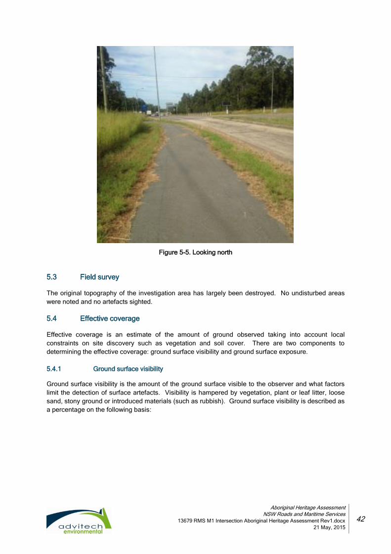
Aboriginal Heritage Assessment
NSW Roads and Maritime Services
13679 RMS M1 Intersection Aboriginal Heritage Assessment Rev1.docx
21 May, 2015
42
Figure 5-5. Looking north
5.3 Field survey
The original topography of the investigation area has largely been destroyed. No undisturbed areas
were noted and no artefacts sighted.
5.4 Effective coverage
Effective coverage is an estimate of the amount of ground observed taking into account local
constraints on site discovery such as vegetation and soil cover. There are two components to
determining the effective coverage: ground surface visibility and ground surface exposure.
5.4.1 Ground surface visibility
Ground surface visibility is the amount of the ground surface visible to the observer and what factors
limit the detection of surface artefacts. Visibility is hampered by vegetation, plant or leaf litter, loose
sand, stony ground or introduced materials (such as rubbish). Ground surface visibility is described as
a percentage on the following basis:

Aboriginal Heritage Assessment
NSW Roads and Maritime Services
13679 RMS M1 Intersection Aboriginal Heritage Assessment Rev1.docx
21 May, 2015
43
Table 5-1: Ground visibility
Description Ground surface visibility rating %
Very Poor – heavy vegetation, scrub foliage or debris cover, dense tree of scrub cover. 0-9%
Poor – moderate level of vegetation, scrub, and or tree cover. Some small patches of soil surface visible in animal tracks, erosion, scalds, blowouts etc, in isolated patches.
10-29%
Fair – moderate levels of vegetation, scrub and or tree cover. Moderate sized patches of soil surface visible, possibly associated with animal, stock tracks, unsealed walking tracks, erosion, blow outs etc, soil surface visible as moderate to small patches, but across a larger section of the study area than in poor visibility
30-49%
Very Good – low levels of vegetation/scrub cover. Higher incidence of soil surface visible due to recent or past land-use practices such as ploughing, mining etc.
60-79%
Excellent – very low to non-existent levels of vegetation/scrub cover. High incidence of soil surface visible due to past or recent land use practices, such as ploughing, grading, mining etc.
80-100%
It should be noted that the estimation of ground surface visibility is purely subjective to the observer;
however, consistency is achieved by the observer providing the assessment for the study area as has
been done in this assessment.
5.4.2 Ground surface exposure
Ground surface exposure is the amount of surface with a likelihood of revealing subsurface cultural
materials rather than just an observation of the amount of bare ground. This is generally attributable to
erosion (aggrading, eroding or stable) and the prevailing sedimentary conditions that would be
sufficient to reveal cultural materials on the surface. The effective coverage for the study area was
determined for both visibility and exposure ratings and the following table details the visibility rating
system used.
Table 5-2. Effective coverage for the investigation area
SU Landform Area (m2)
Vis. % Exp. %
Exposure type
Previous disturbances
Present disturbances
Limiting visibility factors
Effective coverage (m2)
1 Flat 32,450 15% 30% drainage lines, erosion, excavation
clearing, excavation, construction, drainage
drainage, roads, under & above ground services, carpark
low growth, leaf litter, grasses, sealed surfaces
1,460
2 Low hill slope
16,360 35% 15% drainage lines, erosion, excavation
clearing, excavation, construction, drainage
roads, under & above ground services, carpark
low growth, leaf litter, grasses, rubbish, fencing, sealed surfaces
859
3 Flat 19,130 50% 50% drainage lines, erosion, excavation
clearing, excavation, construction, drainage
drainage, roads, under & above ground services, fencing, surface clearance
low growth, leaf litter, grasses, rubbish
4,783
4 Low hill slope
19,580 15% 60% drainage lines, erosion, excavation
clearing, excavation
drainage, under & above ground, services
low growth, leaf litter, grasses
1,762
Totals 87,520 8,864
Effective coverage % 27.32%

Aboriginal Heritage Assessment
NSW Roads and Maritime Services
13679 RMS M1 Intersection Aboriginal Heritage Assessment Rev1.docx
21 May, 2015
44
The level and nature of the effective survey coverage, 27.32%, is considered satisfactory to provide an
effective assessment of the Aboriginal sites potentially present within the investigation area. The
coverage was comprehensive for obtrusive site types (for example, petroglyphs and scarred trees), but
somewhat limited for the less obtrusive surface stone artefact sites. Surface visibility constraints
included vegetation cover and minimal exposures combined with the destruction of the topography for
roadworks which has removed the original landscape and any associated cultural materials.
In view of the predictive modelling (see Section 4) and the results obtained from the effective
coverage, it is concluded that the survey provides a valid basis for determining the probable impacts of
the proposal and formulating recommendations for the management of the identified sites and
potential Aboriginal sites.
5.5 Results
No objects or sites were identified; this is likely due to the high level of land use and impacts across
the entire investigation area which would have destroyed any evidence of past occupation.
Aboriginal Heritage Assessment
NSW Roads and Maritime Services
13679 RMS M1 Intersection Aboriginal Heritage Assessment Rev1.docx
21 May, 2015
45
6. DUE DILIGENCE IMPACT ASSESSMENT
The archaeological record is a non-renewable resource that is affected by many processes and
activities. As outlined in Section 4, the various natural processes and human activities would have
impacted on archaeological deposits through both site formation and taphonomic processes.
Section 4 also describes the impacts within the study area, showing how these processes and
activities have disturbed the landscape and associated cultural materials in varying degrees.
6.1 Impacts
Detailed descriptions of the possible impacts are provided in Section 1.2, and the CoP describes
impacts to be rated as follows:
type of impact: direct, indirect or none;
degree of impact: total, partial or none; and
consequence of impact: total loss, partial loss, or no loss of value.
As no sites or PADs were identified, there are no impacts and no loss of value on the archaeological
record within the study area.
6.2 Cumulative Impacts
The cumulative impact to Aboriginal heritage in terms of scientific inquiry in this location is unknown
given that:
the net development footprint (that is, the area of direct impact) is small and does not affect
a high proportion of any particular landform present within the region;
no sites were identified within the study area;
no PADs were identified within the study area; and
the placement of the development within this area and within a disturbed context ensures
the cumulative impacts, if any, are low.
No objects of Aboriginal heritage were identified within the areas identified by RMS.

Aboriginal Heritage Assessment
NSW Roads and Maritime Services
13679 RMS M1 Intersection Aboriginal Heritage Assessment Rev1.docx
21 May, 2015
46
7. MITIGATION AND MANAGEMENT STRATEGIES
The Advitech Environmental believes that Aboriginal cultural heritage is to be recognised as a finite
and valuable resource and adopt the following viewpoints in order to form mitigation and management
strategies for Aboriginal heritage:
Aboriginal community members are pivotal in the identification, assessment, and
management of Aboriginal cultural heritage, as it is primarily Aboriginal people who should
determine the cultural significance of their heritage;
places of Aboriginal cultural value within the Newcastle LGA are to be actively conserved
and managed to retain cultural values. Appropriate conservation actions should be taken
according to the level of significance;
Aboriginal cultural heritage is to be actively managed during the development process, to
ensure appropriate conservation and impact mitigation outcomes are achieved;
compliance with relevant statutory controls, specifically the NPW Act and EPA Act, is to
required for all development and heritage programs; and
sustainable, ongoing management strategies for Aboriginal cultural heritage management
should maximise the involvement of Aboriginal parties.
One of the most important considerations in selecting the most suitable and appropriate strategy is the
recognition that Aboriginal cultural heritage is very important to the local Aboriginal community.
Decisions about the management of sites and potential archaeological deposits should be made in
consultation with the appropriate local Aboriginal community. Note that a representative from the
Mindaribba Local Aboriginal Land Council, Mr James Sinclair, attended the survey with the
archaeologist.
No objects of Aboriginal heritage were identified within the study areas identified by RMS and,
therefore, no mitigation or management strategies are necessary.
7.1.1 Conversation and Protection
The OEH is responsible for the conservation and protection of Indigenous sites. Conservation is the
first avenue and is suitable for all sites, especially those considered of high archaeological significance
and or cultural significance. Conservation includes the processes of looking after an indigenous site or
place so as to retain its cultural significance and are managed in ways that are consistent with the
nature of peoples’ attachment to them.
No sites or PADs were identified and no indication was received from Mr James Sinclair that the site
had any cultural significance and, as such, conservation or protection is not justified from an
archaeological or scientific perspective.
7.1.2 Test excavations
An Aboriginal Heritage Impact Permit (AHIP) is no longer required to undertake test excavations
(providing the excavations are in accordance with the OEH DDCoP). Subsurface testing is appropriate
when a Potential Archaeological Deposit (PAD) has been identified, and it can be demonstrated that
sub-surface Aboriginal objects with potential conservation value have a high probability of being
present, and that the area cannot be substantially avoided by the proposed activity. However, testing
may only be undertaken as per the OEH CoP and discussions/consultation with the local Aboriginal
community.
No sites or PADs were identified and, as such, further investigation is not justified.

Aboriginal Heritage Assessment
NSW Roads and Maritime Services
13679 RMS M1 Intersection Aboriginal Heritage Assessment Rev1.docx
21 May, 2015
47
7.1.3 AHIP
If harm will occur to an Aboriginal object or Place, then an AHIP is required from the OEH. An AHIP is
required when a site is identified but its extent, the nature of its contents, level of integrity and or its
significance cannot be adequately assessed through a surface survey. In this case, if a systematic
excavation of the known site could provide benefits and information for the Aboriginal community and
or archaeological study of past Aboriginal occupation, a salvage program may be an appropriate
strategy to further assess the site to determine its extent, nature, content, integrity and significance.
The AHIP may also include surface collection of artefacts.
No sites or PADs were identified and, as such, an AHIP is not required.

Aboriginal Heritage Assessment
NSW Roads and Maritime Services
13679 RMS M1 Intersection Aboriginal Heritage Assessment Rev1.docx
21 May, 2015
48
8. CONCLUSION AND RECOMMENDATIONS
As noted in Section 3, a number of known Aboriginal sites were located in proximity to the study area,
many of which have been destroyed. Due to the presence of these nearby sites, there is a very low
potential that more archaeological objects exist within the defined study area. However, the vast
clearance of vegetation, previous European use, large scale road levelling and construction, drainage
works and diversions, associated infrastructure and signage indicate that the study area is highly
disturbed and any artefacts originally present in the area would have most likely been destroyed. The
proposed construction activities will impact on the soil profiles surrounding the road corridors;
however, due to the highly disturbed nature of these sites, it is concluded that no objects of Aboriginal
heritage will be impacted by the proposed works.
8.1 Discussion
As no sites have been identified, the results of the investigation are discussed below in terms of overall
site integrity, local and regional contexts, and predictive modelling.
8.1.1 Integrity
The integrity of the study area has been largely destroyed by the construction of the M1 Freeway,
Weakleys Drive and John Renshaw Drive, as well as associated infrastructure such as drainage lines
and culverts, above and underground services, signage and access tracks. Due to such disturbances,
the integrity of the investigation area is lost and any sites that may have been present would have
been destroyed.
8.1.2 Interpretation and occupation model
Given the high level of disturbance throughout the investigation area, and the fact that no sites or
PADs were identified, it is not possible to discuss site interpretation or occupation models.
8.1.3 Regional and local context
Given the high level of disturbance throughout the investigation area, and the fact that no sites or
PADs were identified, it is not possible to identify any differences or similarities with other assessments
throughout the region (such as site patterning, site types, land form preference, and so on).
8.1.4 Reassessment of the predictive model
In view of the survey results, the predictive model of site locations remains, as determined, to be
having low to no potential for artefacts to occur within the study area due to its highly disturbed nature.
8.2 Conclusion
Proximity to water was an important factor in past occupation of the area, with sites reducing in
number significantly away from water with most sites located within 50 metres of the tributaries. No
raw materials typically used in the manufacture of stone tools were sighted. The access to both Viney
Creek, Weakleys Creek and the Hexham swamplands nearby would have provided the necessary
resources for occupation of the surrounding area; however, the study area is located over 50 metres
from these water resources and in areas with little elevation. The study area is highly disturbed
thereby further reducing the likelihood of in situ cultural materials to be present. There is low to nil
potential that intact or in situ artefacts that would contribute to archaeological knowledge remain within
the study area.
No sites or PADs were identified and, as such, an AHIP is not required.

Aboriginal Heritage Assessment
NSW Roads and Maritime Services
13679 RMS M1 Intersection Aboriginal Heritage Assessment Rev1.docx
21 May, 2015
49
8.3 Recommendations
8.3.1 On site work staff, contractors and others
The persons responsible for the management of works on site will ensure that all staff, contractors and
others involved in construction and maintenance related activities are made aware of the statutory
legislation protecting sites and places of significance. Of particular importance is the National Parks
and Wildlife Amendment (Aboriginal Objects and Aboriginal Places) Regulation 2010, under the NPW
Act .
8.3.2 Areas to be impacted
If the defined areas to be impacted are to be altered and the location proposed is not within the study
area, then further investigation of the proposed areas to be impacted will be required. In particular, if
the construction works are varied to the extent that impact will occur within 5 metres of the registered
site AHIMS #38-4-0551 (being GPS location AMG 56H LJ Easting 371846 Northing 6368253) may
occur, then a fenced buffer zone to protect this site should the erected in case the solitary artefact still
remains.

Aboriginal Heritage Assessment
NSW Roads and Maritime Services
13679 RMS M1 Intersection Aboriginal Heritage Assessment Rev1.docx
21 May, 2015
50
9. REFERENCES
Attenbrow V. 2010. Sydneys Aboriginal Past: Investigating the archaeological and historical records.
2nd
Edition. UNSW Press Ltd, Sydney.
Bonhomme T. 1996. An Archaeological Survey for Aboriginal Sites at Tourle St., Newcastle, NSW.
Conducted for BHP Newcastle, NSW. Mudgeeraba,
Burnham Burnham 1988. Burnham Burnham's Aboriginal Australia, North Ryde, Angus & Robertson.
Brayshaw H. 1986. Aborigines of the Hunter Valley: a study of colonial records. Scone. Scone and
Upper Hunter Historical Society.
Gunson N. (ed) 1974. Australian Reminiscences and Papers of L. E. Threlkeld: Missionary to the
Aborigines 1824-1859. Volumes 1 & 2. Australian Aboriginal Studies No. 40. AIAS, Canberra.
Hartley D. 1995. Men of Their Time – Pioneers of the Hunter River, North Arm Cove, Aquila
Agribusiness Pty Ltd.
Hiscock P. 1986. Technological changes in the Hunter River Valley and the interpretation of late
Holocene Change in Australia in Archaeology in Oceania 21:40-50.
Hughes P. J. and Sullivan M. 1984. Environmental Approaches to the Assessment of Archaeological
Significance. In S. Sullivan and S. Bowdler (eds) Site Surveys and Significance Assessments in
Australian Archaeology. Pp: 34-47.
Koettig, M. 1986. Assessment of Archaeological Sites along the Proposed Singleton to Glennies Creek
Water Pipeline Route and the Reservoir Site at Apex Lookout, Hunter Valley, New South Wales.
Unpublished report for The Public Works Department.
Kuskie P, 1997. An Aboriginal Archaeological Assessment of a Newcastle City Council Property at the
Corner of Lenaghan’s Drive and John Renshaw Drive, Beresfield. Unpublished report to Newcastle
City Council.
--- 2002. An Aboriginal Archaeological Assessment of Lot 2 DP 873320, Black Hill, Lower Hunter
Valley, New South Wales. Unpublished report to PJ & SE Evans.
--- 2004. An Aboriginal Heritage Impact Assessment of the proposed Stage 3 Freeway extension
Business Park at Beresfield, Hunter Valley, NSW. Unpublished report prepared for Thornton Land
Company Pty. Ltd. by South East Archaeology Pty. Ltd.
--- 2007. An Aboriginal Heritage Impact Assessment of the proposed freeway Business Park at
Beresfield, Hunter Valley, NSW. Unpublished report prepared for Thornton Land Company Pty. Ltd.
by South East Archaeology Pty. Ltd.
--- 2008. Freeway North and South business parks, Beresfield: Aboriginal Heritage Management Plan
(Working Draft). Report prepared for Thornton Land Company Pty. Ltd. by South East Archaeology
Pty. Ltd.
Matthei L.E. 1995. Soil Landscapes of the Newcastle 1:100 000 Sheet Report, Department of Land
and Water Conservation, Sydney.
Dept. of Resources and Energy, Newcastle Geological Map, 1966 downloaded from
http://www.resourcesandenergy.nsw.gov.au/__data/assets/image/0006/367044/Newcastle-
250K-Geological-Sheet-SI56-02-1st-edition.jpg on 20th March, 2015.
McBryde I. 1974. Aboriginal Prehistory in New England: An archaeological survey of northeastern
NSW. Sydney, Sydney University Press.

Aboriginal Heritage Assessment
NSW Roads and Maritime Services
13679 RMS M1 Intersection Aboriginal Heritage Assessment Rev1.docx
21 May, 2015
51
McCardle P 2012. Aboriginal Heritage Impact Assessment, QR Hexham Train Support Facility.
Unpublished report to QR National.
McDonald J 2008. Dreamtime Superhighway: Sydney Basin Rock Art and Prehistoric Information
Exchange in Terra Australis 27. ANU E Press. Canberra.
Newcastle City Council 2012. Development of Newcastle City-wide Floodplain Risk Management
Study and Plan. A Compilation of Background Research and Investigations, Newcastle.
--- Newcastle Stormwater Management Plan 2004, Newcastle City Council, Newcastle downloaded
from http://www.newcastle.nsw.gov.au/__data/assets/pdf_file/0013/7510/newcastle_catchment_
characteristics.pdf on 1st March 2015.
--- Newcastle Local Environmental Plan 2012, Newcastle City Council, Newcastle.
Owen T, & ERM Australia Pty Ltd – Sydney CBD. CTGM Stoney Pinch to Beresfield Upgrade Hunter
Water Corporation Stage 2 (follow-on): Heritage assessment. Unpublished Report for Hunter Water
Corporation.
Renfrew C. and Bahn P. 1991. Archaeology: Theories, Methods and Practice. Thames & Hudson.
London.
Story R. R. W., Galloway, R.H.M. van de Graaff, and A.D. Tweedie 1963, General Report on the Lands
of the Hunter Valley, Land Research Series No. 8, Commonwealth Scientific and Industrial
Research Organisation (C.S.I.R.O), Melbourne.
Threlkeld L. E. 1974, Australian reminiscences & papers of L.E. Threlkeld, missionary to the
Aborigines, 1824-1859, Canberra: Australian Institute of Aboriginal Studies.
Tindale N.B. 1974. Aboriginal Tribes of Australia, University of California Press, Los Angeles
Umwelt (Australia) Pty Limited, 2001. Aboriginal Archaeological Assessment and Sub-surface
Investigation of the Proposed Freeway Industrial Estate at South Beresfield, NSW. Unpublished
report for Landcom NSW.
University of Newcastle. 2000. Whose Traditional Land? Research by John Maynard. Downloaded
from http://www.newcastle.edu.au/__data/assets/pdf_file/0009/41868/Research-document_John-
Maynard_whose-land.pdf on 31 March, 2015.
Waters, M. and D. Kuehn. 1996. The Geoarchaeology of Place: The Effect of Geological Processes on
the Preservation and Interpretation of the Archaeological Record in American Antiquity 61(3):483-
496.
Wobst H.M. 1983. Palaeolithic archaeology - some problems with form, space and time. In G. Bailey
(ed.) Hunter-Gatherer economy in Prehistory: a European perspective, pp 220-225. Advances in
Archaeological Method and Theory. Cambridge University Press, Cambridge.

Appendix I
O EH Du e D i l i g e nc e C o de o f P r ac t i c e

Aboriginal Heritage Assessment
NSW Roads and Maritime Services
13679 RMS M1 Intersection Aboriginal Heritage Assessment Rev0.docx
22 April, 2015
AI.1

Appendix I I
A HI M S Se arc h R esu l t s

AHIMS Web Services (AWS)Extensive search - Site list report
SiteID SiteName Datum Zone Easting Northing Context SiteFeatures SiteTypes Reports
Purchase Order/Reference : Weakleys
Client Service ID : 163721
Site Status
38-4-0463 Site 4;Beresfield; AGD 56 Open site Valid Artefact : - Open Camp Site 4211,102222,1
02568
PermitsContact
38-4-0465 Site 6;Beresfield; Open site Partially
Destroyed
Artefact : - Open Camp Site 4211,102222,1
02568,103090
3432PermitsContact
38-4-0466 Site 7;Beresfield; Open site Valid Artefact : - Isolated Find 4211,102222,1
02568
PermitsContact
38-4-0467 Site 8;Beresfield; Open site Valid Artefact : - Isolated Find 4211,102222,1
02568
PermitsContact
38-4-0469 Site 11;Beresfield; Open site Valid Artefact : - Open Camp Site 4211,102222,1
02568
PermitsContact
38-4-0470 Site 12;Beresfield; Open site Valid Artefact : - Open Camp Site 4211,102222,1
02568
PermitsContact
38-4-0473 Site 2;Beresfield; Open site Valid Artefact : - Isolated Find 4211,102222,1
02568
PermitsContact
38-4-0379 BS2; Open site Partially
Destroyed
Artefact : - Open Camp Site 102222,10256
8
824,1066PermitsContact
38-4-0382 BS6 (duplicate); Open site Partially
Destroyed
Artefact : - Open Camp Site 102568
1066PermitsContact
38-4-0386 BS1. Open site Valid Artefact : - Open Camp Site 102222,10256
8
PermitsContact
38-4-0387 BS2; Open site Valid Artefact : - Open Camp Site 102222
PermitsContact
38-4-0388 BS3 (Holmwood Estate) Open site Destroyed Artefact : - Open Camp Site 102568
965PermitsContact
38-4-0550 Viney Creek 1 Artefact Scatter Open site Valid Artefact : 72 97572,102222
PermitsContact
38-4-0551 John Renshaw Drive Isolated Find Open site Valid Artefact : 1 97572,102568
PermitsContact
Report generated by AHIMS Web Service on 25/02/2015 for Rod Bennison for the following area at Lat, Long From : -32.8191, 151.6268 - Lat, Long To : -32.8087, 151.6433 with a Buffer of 200
meters. Additional Info : Archaeological assessment for review of environmental factors. Number of Aboriginal sites and Aboriginal objects found is 35
This information is not guaranteed to be free from error omission. Office of Environment and Heritage (NSW) and its employees disclaim liability for any act done or omission made on the information and consequences of such
acts or omission.
Page 1 of 3

AHIMS Web Services (AWS)Extensive search - Site list report
SiteID SiteName Datum Zone Easting Northing Context SiteFeatures SiteTypes Reports
Purchase Order/Reference : Weakleys
Client Service ID : 163721
Site Status
38-4-0552 South Beresfield Freeway Industrial Estate Open site Valid Potential
Archaeological
Deposit (PAD) : -
97572,102222
PermitsContact
38-4-0554 Viney Creek 2 Artefact Scatter Open site Valid Artefact : 1 97572,102222,
102398
PermitsContact
38-4-0903 Weakleys 1 Locus C (W1/C) Open site Valid Artefact : 3 102222,10239
8
3144,3431PermitsT RussellContact
38-4-0904 Weakleys 1 Locus D (W1/D) Open site Valid Artefact : 2 102222,10239
8
3144,3431PermitsT RussellContact
38-4-0905 Weakleys 2 Locus A (W2/A) Open site Valid Artefact : 5 102222,10239
8
3144,3431PermitsT RussellContact
38-4-0906 Weakleys 4 Locus A (W4/A) Open site Valid Artefact : 1 102222,10239
8
3144,3431PermitsT RussellContact
38-4-0907 Weakleys 4 Locus B (W4/B) Open site Valid Artefact : 1 102222,10239
8
3144,3431PermitsT RussellContact
38-4-0908 Weakleys 4 Locus C (W4/C) Open site Valid Artefact : 1 102222,10239
8
3144,3431PermitsT RussellContact
38-4-0909 Weakleys 7 Locus A (W7/A) Open site Valid Artefact : 1 102398
3144,3431PermitsT RussellContact
38-4-0926 Weakleys 23 Locus F (W23/F) Open site Valid Artefact : 1
PermitsT RussellContact
38-4-0464 Site 5;Beresfield; Open site Valid Artefact : - Open Camp Site 4211,102222,1
02568
PermitsContact
38-4-0391 BS6; Open site Partially
Destroyed
Artefact : - Open Camp Site
1066PermitsContact
38-4-1287 CTGM1 AT1 Open site Partially
Destroyed
Artefact : 1 103089
3374PermitsContact
Report generated by AHIMS Web Service on 25/02/2015 for Rod Bennison for the following area at Lat, Long From : -32.8191, 151.6268 - Lat, Long To : -32.8087, 151.6433 with a Buffer of 200
meters. Additional Info : Archaeological assessment for review of environmental factors. Number of Aboriginal sites and Aboriginal objects found is 35
This information is not guaranteed to be free from error omission. Office of Environment and Heritage (NSW) and its employees disclaim liability for any act done or omission made on the information and consequences of such
acts or omission.
Page 2 of 3

AHIMS Web Services (AWS)Extensive search - Site list report
SiteID SiteName Datum Zone Easting Northing Context SiteFeatures SiteTypes Reports
Purchase Order/Reference : Weakleys
Client Service ID : 163721
Site Status
38-4-1210 Beresfield WP IF 1 Destroyed Artefact : 1 101939,10256
8,103090
3432PermitsMindaribba Local Aboriginal Land CouncilContact
38-4-1211 Beresfield WP IF 2 Destroyed Artefact : 1 101939,10256
8,103090
3432PermitsMindaribba Local Aboriginal Land CouncilContact
38-4-1212 Beresfield WP IF 3 Destroyed Artefact : 1 101939,10309
0
3432PermitsMindaribba Local Aboriginal Land CouncilContact
38-4-1213 Beresfield WP IF 4 Destroyed Artefact : 1 101939,10309
0
3432PermitsMindaribba Local Aboriginal Land CouncilContact
38-4-1214 Beresfield WP AS 1 Partially
Destroyed
Artefact : 1 101939,10256
8,103090
3432PermitsMindaribba Local Aboriginal Land CouncilContact
38-4-1217 CTGM PAD2 Partially
Destroyed
Potential
Archaeological
Deposit (PAD) : 1
101939,10256
8,103090
3432,3761PermitsContact
38-4-1336 Black Hill 1 Valid Artefact : 1
PermitsContact
38-4-1689 CTGM-Beresfield East artefacts Open site Valid Artefact : -
PermitsContact
Report generated by AHIMS Web Service on 25/02/2015 for Rod Bennison for the following area at Lat, Long From : -32.8191, 151.6268 - Lat, Long To : -32.8087, 151.6433 with a Buffer of 200
meters. Additional Info : Archaeological assessment for review of environmental factors. Number of Aboriginal sites and Aboriginal objects found is 35
This information is not guaranteed to be free from error omission. Office of Environment and Heritage (NSW) and its employees disclaim liability for any act done or omission made on the information and consequences of such
acts or omission.
Page 3 of 3

AHIMS Web Services (AWS)Extensive search - Site list report
SiteID SiteName Datum Zone Easting Northing Context SiteFeatures SiteTypes Reports
Purchase Order/Reference : Weakleys Roundabout
Client Service ID : 157070
Site Status
38-4-0463 Site 4;Beresfield; AGD 56 373000 6368200 Open site Valid Artefact : - Open Camp Site 4211,102222,1
02568
PermitsContact
38-4-0465 Site 6;Beresfield; Partially
Destroyed
Artefact : - Open Camp Site 4211,102222,1
02568,103090
3432PermitsContact
38-4-0466 Site 7;Beresfield; Valid Artefact : - Isolated Find 4211,102222,1
02568
PermitsContact
38-4-0467 Site 8;Beresfield; Valid Artefact : - Isolated Find 4211,102222,1
02568
PermitsContact
38-4-0468 Site 9;Beresfield; Valid Artefact : - Open Camp Site 4211,102568
3761PermitsContact
38-4-0469 Site 11;Beresfield; Valid Artefact : - Open Camp Site 4211,102222,1
02568
PermitsContact
38-4-0470 Site 12;Beresfield; Valid Artefact : - Open Camp Site 4211,102222,1
02568
PermitsContact
38-4-0471 Site 10;Beresfield; Valid Artefact : - Open Camp Site 4211,102568
PermitsContact
38-4-0472 Site 1;Beresfield; Valid Artefact : - Isolated Find 4211,102222,1
02568
PermitsContact
38-4-0473 Site 2;Beresfield; Valid Artefact : - Isolated Find 4211,102222,1
02568
PermitsContact
38-4-0474 Site 3;Beresfield; Valid Artefact : - Isolated Find 4211,102568
PermitsContact
38-4-0375 Black Hill 1, BH1 Destroyed Artefact : - Open Camp Site 102222,10256
8
658,745,819,831,1062,1074PermitsContact
38-4-0329 MB2; Destroyed Artefact : - Open Camp Site 2410,102568
PermitsContact
38-4-0379 BS2; Partially
Destroyed
Artefact : - Open Camp Site 102222,10256
8
824,1066PermitsContact
Report generated by AHIMS Web Service on 05/12/2014 for Rod Bennison for the following area at Lat, Long From : -32.8186, 151.6276 - Lat, Long To : -32.8082, 151.6441 with a Buffer of
1000 meters. Additional Info : RMS Cultural Heritage Impact Assessmnet. Number of Aboriginal sites and Aboriginal objects found is 75
This information is not guaranteed to be free from error omission. Office of Environment and Heritage (NSW) and its employees disclaim liability for any act done or omission made on the information and consequences of such
acts or omission.
Page 1 of 6

AHIMS Web Services (AWS)Extensive search - Site list report
SiteID SiteName Datum Zone Easting Northing Context SiteFeatures SiteTypes Reports
Purchase Order/Reference : Weakleys Roundabout
Client Service ID : 157070
Site Status
38-4-0380 BS4; Partially
Destroyed
Artefact : - Open Camp Site 102568
1066PermitsContact
38-4-0381 BS5 (duplicate); Partially
Destroyed
Artefact : - Open Camp Site
1066PermitsContact
38-4-0382 BS6 (duplicate); Partially
Destroyed
Artefact : - Open Camp Site 102568
1066PermitsContact
38-4-0386 BS1. Valid Artefact : - Open Camp Site 102222,10256
8
PermitsContact
38-4-0387 BS2; Valid Artefact : - Open Camp Site 102222
PermitsContact
38-4-0388 BS3 (Holmwood Estate) Destroyed Artefact : - Open Camp Site 102568
965PermitsContact
38-4-0389 BS4 (duplicate); Partially
Destroyed
Artefact : - Open Camp Site 102568
1066PermitsContact
38-4-0390 BS5; Partially
Destroyed
Artefact : - Open Camp Site 102568
1066PermitsContact
38-4-0550 Viney Creek 1 Artefact Scatter Valid Artefact : 72 97572,102222
PermitsContact
38-4-0551 John Renshaw Drive Isolated Find Valid Artefact : 1 97572,102568
PermitsContact
38-4-0552 South Beresfield Freeway Industrial Estate Valid Potential
Archaeological
Deposit (PAD) : -
97572,102222
PermitsContact
38-4-0554 Viney Creek 2 Artefact Scatter Valid Artefact : 1 97572,102222,
102398
PermitsContact
38-4-0561 ISF1 Valid Artefact : 1
1342PermitsContact
38-4-0604 BLACK HILL 7 (BH7) Valid Artefact : - 98227,102222,
102568
PermitsContact
Report generated by AHIMS Web Service on 05/12/2014 for Rod Bennison for the following area at Lat, Long From : -32.8186, 151.6276 - Lat, Long To : -32.8082, 151.6441 with a Buffer of
1000 meters. Additional Info : RMS Cultural Heritage Impact Assessmnet. Number of Aboriginal sites and Aboriginal objects found is 75
This information is not guaranteed to be free from error omission. Office of Environment and Heritage (NSW) and its employees disclaim liability for any act done or omission made on the information and consequences of such
acts or omission.
Page 2 of 6

AHIMS Web Services (AWS)Extensive search - Site list report
SiteID SiteName Datum Zone Easting Northing Context SiteFeatures SiteTypes Reports
Purchase Order/Reference : Weakleys Roundabout
Client Service ID : 157070
Site Status
38-4-0671 WFC1 Donaldson Mine Valid Artefact : 3 98344
PermitsContact
38-4-0673 ISF4 Donaldson Mine Valid Artefact : 1 98344,102222
1902PermitsContact
38-4-0638 Donaldson Monitoring Site 6 (DMS6) Valid Modified Tree
(Carved or Scarred) :
1
PermitsContact
38-4-0639 Donaldson Monitoring Site 5 (DMS5) Valid Artefact : 1 102222
PermitsContact
38-4-0621 Donaldson Monitoring Site 2 (DMS2) Valid Artefact : 1 102222,10239
8
3144,3431PermitsContact
38-4-0709 BGC 1 Valid Artefact : 55 102568,10261
5
1788,2141,2952PermitsContact
38-4-0868 MB1. Valid Artefact : 1 102568
PermitsT RussellContact
38-4-0798 Beresfield Substation 1 (BSS1) Valid Artefact : 1, Potential
Archaeological
Deposit (PAD) : -
102568
2088PermitsT RussellContact
38-4-0901 Weakleys 1 Locus A (W1/A) Valid Artefact : 1 102222,10239
8
3144,3431PermitsT RussellContact
38-4-0902 Weakelys 1 Locus B (W1/B) Valid Artefact : 2 102222,10239
8
3144,3431PermitsT RussellContact
38-4-0903 Weakleys 1 Locus C (W1/C) Valid Artefact : 3 102222,10239
8
3144,3431PermitsT RussellContact
38-4-0904 Weakleys 1 Locus D (W1/D) Valid Artefact : 2 102222,10239
8
3144,3431PermitsT RussellContact
38-4-0905 Weakleys 2 Locus A (W2/A) Valid Artefact : 5 102222,10239
8
3144,3431PermitsT RussellContact
38-4-0906 Weakleys 4 Locus A (W4/A) Valid Artefact : 1 102222,10239
8
Report generated by AHIMS Web Service on 05/12/2014 for Rod Bennison for the following area at Lat, Long From : -32.8186, 151.6276 - Lat, Long To : -32.8082, 151.6441 with a Buffer of
1000 meters. Additional Info : RMS Cultural Heritage Impact Assessmnet. Number of Aboriginal sites and Aboriginal objects found is 75
This information is not guaranteed to be free from error omission. Office of Environment and Heritage (NSW) and its employees disclaim liability for any act done or omission made on the information and consequences of such
acts or omission.
Page 3 of 6

AHIMS Web Services (AWS)Extensive search - Site list report
SiteID SiteName Datum Zone Easting Northing Context SiteFeatures SiteTypes Reports
Purchase Order/Reference : Weakleys Roundabout
Client Service ID : 157070
Site Status
3144,3431PermitsMr.Peter KuskieRecordersT RussellContact
38-4-0907 Weakleys 4 Locus B (W4/B) Valid Artefact : 1 102222,10239
8
3144,3431PermitsT RussellContact
38-4-0908 Weakleys 4 Locus C (W4/C) Valid Artefact : 1 102222,10239
8
3144,3431PermitsT RussellContact
38-4-0909 Weakleys 7 Locus A (W7/A) Valid Artefact : 1 102398
3144,3431PermitsT RussellContact
38-4-0915 Weakleys 15 Locus F (W15/F) Valid Artefact : 8
PermitsT RussellContact
38-4-0916 Weakleys 15 Locus G (W15/G) Valid Artefact : 19
PermitsT RussellContact
38-4-0917 Weakleys 18 Locus A (W15/A) Valid Artefact : 1
PermitsT RussellContact
38-4-0918 Weakleys 20 Locus A (W20/A) Valid Artefact : 98 102568
PermitsT RussellContact
38-4-0919 Weakleys 20 Locus B (W20/B) Valid Artefact : 6
PermitsT RussellContact
38-4-0920 Weakleys 21 Locus A (W21/A) Valid Artefact : 4
PermitsT RussellContact
38-4-0921 Weakleys 22 Locus A (W22/A) Valid Artefact : 22
PermitsT RussellContact
38-4-0922 Weakleys 23 Locus A (W23/A) Valid Artefact : 1
PermitsT RussellContact
38-4-0923 Weakleys 23 Locus B (W23/B) Valid Artefact : 1
PermitsT RussellContact
38-4-0924 Weakleys 23 Locus D (W23/D) Valid Artefact : 1
PermitsT RussellContact
38-4-0925 Weakleys 23 Locus E (W23/E) Valid Artefact : 2
PermitsT RussellContact
38-4-0926 Weakleys 23 Locus F (W23/F) Valid Artefact : 1
PermitsT RussellContact
38-4-0464 Site 5;Beresfield; Valid Artefact : - Open Camp Site 4211,102222,1
02568
PermitsContact
Report generated by AHIMS Web Service on 05/12/2014 for Rod Bennison for the following area at Lat, Long From : -32.8186, 151.6276 - Lat, Long To : -32.8082, 151.6441 with a Buffer of
1000 meters. Additional Info : RMS Cultural Heritage Impact Assessmnet. Number of Aboriginal sites and Aboriginal objects found is 75
This information is not guaranteed to be free from error omission. Office of Environment and Heritage (NSW) and its employees disclaim liability for any act done or omission made on the information and consequences of such
acts or omission.
Page 4 of 6

AHIMS Web Services (AWS)Extensive search - Site list report
SiteID SiteName Datum Zone Easting Northing Context SiteFeatures SiteTypes Reports
Purchase Order/Reference : Weakleys Roundabout
Client Service ID : 157070
Site Status
38-4-0391 BS6; AGD 56 372360 6369050 Open site Partially
Destroyed
Artefact : - Open Camp Site
1066PermitsContact
38-4-1287 CTGM1 AT1 Partially
Destroyed
Artefact : 1 103089
3374PermitsContact
38-4-1289 CTGM3 AT3 Partially
Destroyed
Artefact : - 103089
3374PermitsContact
38-4-1290 CTGM4 MC Valid Artefact : 1 103089
PermitsContact
38-4-1210 Beresfield WP IF 1 Destroyed Artefact : 1 101939,10256
8,103090
3432PermitsMindaribba Local Aboriginal Land CouncilContact
38-4-1211 Beresfield WP IF 2 Destroyed Artefact : 1 101939,10256
8,103090
3432PermitsMindaribba Local Aboriginal Land CouncilContact
38-4-1212 Beresfield WP IF 3 Destroyed Artefact : 1 101939,10309
0
3432PermitsMindaribba Local Aboriginal Land CouncilContact
38-4-1213 Beresfield WP IF 4 Destroyed Artefact : 1 101939,10309
0
3432PermitsMindaribba Local Aboriginal Land CouncilContact
38-4-1214 Beresfield WP AS 1 Partially
Destroyed
Artefact : 1 101939,10256
8,103090
3432PermitsMindaribba Local Aboriginal Land CouncilContact
38-4-1215 Beresfield WP AS 2 Destroyed Artefact : 15 101939,10308
9
3374PermitsMindaribba Local Aboriginal Land CouncilContact
38-4-1216 CTGM PAD1 Partially
Destroyed
Potential
Archaeological
Deposit (PAD) : 1
101939,10308
9
3374PermitsContact
38-4-1217 CTGM PAD2 Partially
Destroyed
Potential
Archaeological
Deposit (PAD) : 1
101939,10256
8,103090
3432,3761PermitsContact
38-4-1336 Black Hill 1 Valid Artefact : 1
PermitsContact
Report generated by AHIMS Web Service on 05/12/2014 for Rod Bennison for the following area at Lat, Long From : -32.8186, 151.6276 - Lat, Long To : -32.8082, 151.6441 with a Buffer of
1000 meters. Additional Info : RMS Cultural Heritage Impact Assessmnet. Number of Aboriginal sites and Aboriginal objects found is 75
This information is not guaranteed to be free from error omission. Office of Environment and Heritage (NSW) and its employees disclaim liability for any act done or omission made on the information and consequences of such
acts or omission.
Page 5 of 6

AHIMS Web Services (AWS)Extensive search - Site list report
SiteID SiteName Datum Zone Easting Northing Context SiteFeatures SiteTypes Reports
Purchase Order/Reference : Weakleys Roundabout
Client Service ID : 157070
Site Status
38-4-1687 Beresfiled WP-AS2 artefacts Open site Valid Artefact : -
PermitsContact
38-4-1688 CTGM PAD1 artefacts Open site Valid Artefact : -
PermitsContact
38-4-1689 CTGM-Beresfield East artefacts Open site Valid Artefact : -
PermitsContact
38-4-1709 TB IF1 Open site Valid Artefact : -
3761PermitsContact
Report generated by AHIMS Web Service on 05/12/2014 for Rod Bennison for the following area at Lat, Long From : -32.8186, 151.6276 - Lat, Long To : -32.8082, 151.6441 with a Buffer of
1000 meters. Additional Info : RMS Cultural Heritage Impact Assessmnet. Number of Aboriginal sites and Aboriginal objects found is 75
This information is not guaranteed to be free from error omission. Office of Environment and Heritage (NSW) and its employees disclaim liability for any act done or omission made on the information and consequences of such
acts or omission.
Page 6 of 6

Technical Memo
M1 Intersection with John Renshaw Drive
and Weakleys Drive, Beresfield – Proposed
compound site and lane widening
Prepared for: Aurecon Group
14 January 2016
Rev 0

Report Details
Technical Memo - M1 Intersection with John Renshaw Drive and Weakleys Drive, Beresfield
Filename: 14027 Aurecon RMS M1 Compound and Lane Widening Tech Memo Rev0.docx
Job #:J0150006 Folder #: F13679
Revision: 0
Date: 14 January, 2016
Prepared For
Aurecon Group
Mike Luger, Technical Director
Email: [email protected], Mobile: 0468 987 874
Level 5 116 Military Road Neutral Bay NSW 2089
Prepared By
Advitech Pty Limited t/a Advitech Environmental
ABN: 29 003 433 458
Viki Gordon, Senior Archaeologist
Email: [email protected]; Telephone: 02 4924 5400; Mobile: 0411 756 283
Facsimile: 02 4967 3772, Web: www.advitech.com.au, General Email: [email protected]
7 Riverside Drive Mayfield West NSW 2304
PO Box 207 Mayfield NSW 2304
History
Date Revision Comments
14 January, 2016 0 Technical Memo
Endorsements
Function Signature Name and Title Date
Prepared by Viki Gordon
Senior Archaeologist 14 January, 2016
Authorised for Release by
Dr Rod Bennison
Lead Environmental Scientist 14 January, 2016
DISCLAIMER - Any representation, statement, opinion or advice expressed or implied in this document
is made in good faith, but on the basis that liability (whether by reason of negligence or otherwise) is
strictly limited to that expressed on our standard “Conditions of Engagement”.
INTELLECTUAL PROPERTY – All Intellectual Property rights in this document remain the property
of Advitech Pty Ltd. This document must only be used for the purposes for which it is provided and not otherwise reproduced, copied or distributed without the express consent of Advitech.

Technical Memo
Aurecon Group
14027 Aurecon RMS M1 Compound and Lane Widening Tech Memo Rev0.docx
14 January, 2016
i
EXECUTIVE SUMMARY
The M1 Pacific Motorway is a route of national significance forming the main road transport corridor
between Sydney to Newcastle and is an integral link of the Pacific Motorway servicing the north coast
of NSW and coastal Queensland. The current roundabout, where the northern extreme of the M1
meets John Renshaw Drive and Weakleys Drive, forms a significant chokepoint for motorway users
and provides a popular light vehicle rest area and a driver reviver stop for travellers particularly at peak
holiday times. Roads and Maritime propose to upgrade the area to traffic control signals in order to
reduce traffic congestion and delays and increase safety for motorists. The project involves both major
construction works of new sections and improvement works of existing sections to facilitate safer and
more efficient travel. This report specifically relates to a proposed compound site and an extended
area of lane widening which will be utilised in the upgrade of the roundabout.
This report has been prepared in order to assist and inform the technical design and concept aspects,
as pertains to Aboriginal heritage and any potential archaeological sites, in regard to the possible
compound location and extended lane widening. To avoid any unintentional impacts to Aboriginal
objects or places a brief technical assessment and field survey was undertaken on 11th December,
2015. This was carried out by Advitech Environmental and in accordance with the methodology
prescribed under the Office of Environment and Heritage Code of Practice for Archaeological
Investigation of Aboriginal Objects in NSW (CoP) (DECCW, 2010) and the Due Diligence Code of
Practice for the Protection of Aboriginal Objects in New South Wales (DECCW, 2010). However it
should be noted that this report does not form a Due Diligence Assessment or complete
Archaeological Survey.
There are no current registered Aboriginal sites within the study area, however there are registered
sites in the surrounding areas. Only one registered site, consisting of a solitary artefact, remains within
proximity to the impact zone and this is currently described by Aboriginal Heritage Information System
(AHIMS) as being partially destroyed. Due to the highly disturbed nature of the study area, there is
only a low to nil potential that this solitary artefact remains or that more archaeological objects exist
within the subject area. A number of known Aboriginal sites are located within proximity to the study
area but are well outside the proposed impact zone. The field survey of the study area did not reveal
any archaeological artefacts or sites. Due to the highly disturbed nature of the study area, there is only
a low potential that archaeological objects remain within the subject area.
The result of this technical assessment is that it is considered likely that no archaeological sites will be
impacted upon by the development in the assessed area, however it should be noted that no
Aboriginal cultural assessment or consultation of the area and its possible cultural significance was
undertaken for this technical assessment.
The survey of the study area did not reveal any resources or artefacts and this is attributed to both the
highly disturbed nature of the site and the site lacking landform features considered desirable for
occupation other than of an opportunistic nature, such as foraging or hunting. Regional and local
archaeological studies, and the ensuing predictive modelling, indicates the area would most likely only
have contained objects or sites reflective of short term occupation such as solitary or low density
artefact scatters.
The following recommendations are made:
1. The persons responsible for the management of onsite works will ensure that all staff,
contractors and others involved in construction and maintenance related activities are made
aware of the statutory legislation protecting sites and places of significance. Of particular

Technical Memo
Aurecon Group
14027 Aurecon RMS M1 Compound and Lane Widening Tech Memo Rev0.docx
14 January, 2016
ii
importance is the National Parks and Wildlife Amendment (Aboriginal Objects and Aboriginal
Places) Regulation 2010, under the National Parks and Wildlife Act 1974;
2. If the defined areas to be impacted are altered and the location proposed is not within the
study area, then further archaeological investigation of the proposed areas to be impacted will
be required;
3. Further investigation of the study area, in consultation with Local Aboriginal community
members must be undertaken once definitive plans and impacts to the area are known; and
4. If the construction works are varied to the extent that impact will occur within 5 metres of
registered site AHIMS #38-4-0465 (being GPS location AMG 56H LJ Easting 372300 Northing
6368250), then a fenced buffer zone to protect this site should the erected in case the solitary
artefact still remains, if indeed it can be located.

Technical Memo
Aurecon Group
14027 Aurecon RMS M1 Compound and Lane Widening Tech Memo Rev0.docx
14 January, 2016
iii
TABLE OF CONTENTS
EXECUTIVE SUMMARY __________________________________________________________ I
1. INTRODUCTION ____________________________________________________________ 1
1.1 The Study Areas 2
1.2 Previous archaeological assessment of the study areas by Peter Kuskie (1997) 3
2. LANDSCAPE CONTEXT _____________________________________________________ 6
2.1 Topography 6
2.2 Geomorphology 7
2.3 Soils 7
2.4 Hydrology 8
2.5 Landscape History, Uses and Disturbances 8
2.6 Resources 9
2.7 Ethno-historical 9
2.8 Models of Past Aboriginal Land Use 9
2.9 Predictive Model 10
3. ARCHAEOLOGICAL SURVEY _______________________________________________ 10
3.1 Methodology 10
3.2 Landforms 11
3.3 Field Survey 11
3.4 Effective Coverage of Survey 11
3.5 Results 12
4. CONCLUSION AND RECOMMENDATIONS _____________________________________ 12
4.1 Conclusion 12
4.2 Recommendations 12
5. REFERENCES ____________________________________________________________ 13

Technical Memo
Aurecon Group
14027 Aurecon RMS M1 Compound and Lane Widening Tech Memo Rev0.docx
14 January, 2016
1
1. INTRODUCTION
The M1 Pacific Motorway is a route of national significance forming the main road transport corridor
between Sydney to Newcastle. The current roundabout, where the northern extreme of the M1 meets
John Renshaw Drive and Weakleys Drive, forms a significant chokepoint for motorway users and
provides a popular light vehicle rest area for travellers, particularly at peak holiday times. Roads and
Maritime proposes to upgrade the area to traffic control signals in order to reduce traffic congestion
and delays and increase safety for motorists. This report specifically relates to a proposed compound
site and an extended area of lane widening which will be utilised in the upgrade of the roundabout.
This report has been prepared in order to assist and inform the technical design and concept aspects,
as pertains to Aboriginal heritage and any potential archaeological sites, in regard to the possible
compound location and extended lane widening. To avoid any unintentional impacts to Aboriginal
objects or places a brief technical assessment and field survey was undertaken on 11th December,
2015. This was carried out by Advitech Environmental and in accordance with the methodology
prescribed under the Office of Environment and Heritage (OEH) Code of Practice for Archaeological
Investigation of Aboriginal Objects in NSW (CoP) (DECCW, 2010) and the Due Diligence Code of
Practice for the Protection of Aboriginal Objects in New South Wales (DDCoP) (DECCW, 2010).
It should be noted that this report was prepared by Advitech Pty Limited for Aurecon Group (“the
customer”) in accordance with the scope of work and specific requirements agreed between Advitech
and the customer. This report was prepared with background information, terms of reference and
assumptions agreed with the customer. The report is not intended for use by any other individual or
organisation and as such, Advitech will not accept liability for use of the information contained in this
report, other than that which was intended at the time of writing
Advitech Pty Limited, on behalf of Roads and Maritime, has previously undertaken a Stage 2
Aboriginal Heritage assessment of the areas indicated in Figure 1 and as per the guidelines outlined in
the Roads and Maritime Procedure for Aboriginal Cultural Heritage Consultation and Investigation
(PACHCI) (Roads and Maritime, 2011) on 22 April, 2015.
Figure 1.1 Areas previously assessed by Advitech Pty Limited for M1 project

Technical Memo
Aurecon Group
14027 Aurecon RMS M1 Compound and Lane Widening Tech Memo Rev0.docx
14 January, 2016
2
1.1 The Study Areas
The study areas for the proposed site compound and lane widening area are respectively to the east
and south east of the existing roundabout at the intersection of the M1 Pacific Motorway, Weakleys
Drive and John Renshaw Drive, at Beresfield and as illustrated in Figure 1.3. The location and extent
of the areas assessed are illustrated in Figures 1.2 and 1.3, respectively.
Figure 1.2 Locality of the study area
Figure 1.3 Areas assessed in walk over
Proposed compound area
Extended lane widening

Technical Memo
Aurecon Group
14027 Aurecon RMS M1 Compound and Lane Widening Tech Memo Rev0.docx
14 January, 2016
3
A search of the OEH Aboriginal Heritage Information Management System (AHIMS) register on 5
December, 2014, showed that 71 known Aboriginal sites are currently recorded within one kilometre of
the study area and includes 36 open camp sites, 30 isolated finds, 4 Potential Archaeological Deposits
and 1 scarred tree. 17 of these sites are noted as being either partially or completely destroyed. In
addition, a reduced AHIMS search was conducted at the specific request of Roads and Maritime, in
February, 2015 and indicated 35 known Aboriginal sites within 200m of the study area. The location of
AHIMS sites are shown in Figure 1.4. Registered site AHIMS # 38-4-0465 is described as an open
site recorded within close proximity of the possible impact area of the proposed compound. The
isolated artefact, which is the subject of site #38-4-0551 was not relocated during the survey.
Figure 1.4 Location of AHIMS Registered Sites
1.2 Previous archaeological assessment of the study areas by Peter Kuskie (1997)
In 1997, Kuskie undertook an investigation for the Newcastle City Council in anticipation of its sale of
the relevant property for future development. The study area (see Figures 1.5 and 1.6) incorporated
130 hectares bounded to the north by the New England Highway and John Renshaw Drive, to the west
by Lenaghans Drive, to the south by Black Hill rural residential community and Hexham Wetlands to
the east. The property was described as being low gradient, undulating terrain, in a broad, low ridge,
trending to the north towards Weakleys Flat. In the northeast of the property, a ridge crest fanned into
Hexham Wetlands as a broad, low spur, descending eastward. First order drainage lines are found in
the north, north-east and north west of the study area and runoff from the ridge crest drains into
Hexham Wetland.

Technical Memo
Aurecon Group
14027 Aurecon RMS M1 Compound and Lane Widening Tech Memo Rev0.docx
14 January, 2016
4
Figure 1.5 Area studied by Kuskie (1997)
Figure 1.6 Hatched line indicates transects undertaken by Kuskie (1997) in current study area i.e. no
transects of the relevant study area were made
The study area was found to have been largely cleared of vegetation with some tall, open eucalypt
mature forest trees remaining. Dominant species were noted as Spotted Gum, Broad-leaved Ironbark,
Grey Ironbark, Thin-leaved Stringybark, Grey Gum and Narrow-leaved Stringbark. Lesser
occurrences of other species recorded include Smooth-barked Apple, Rough-barked Apple, White
Mahogany, Red Bloodwood and Blackbutt. The understorey contained vegetation of Blackthorn,
several species of paperbark and wattles, with Forest Gum occuring on some lower slopes. Along
drainage lines, Prickly-leaved Paperbark, Grey Myrtle, Red Ash and Lantana are common. Past land
use practices and removal of trees had left pasture grasses, which significantly reduced visibility

Technical Memo
Aurecon Group
14027 Aurecon RMS M1 Compound and Lane Widening Tech Memo Rev0.docx
14 January, 2016
5
across the study area. The study area also contained vehicle tracks, a 33kV transmission line and
water pipeline easement.
Sufficient resources for hunting were available in the Hunter Wetland areas including Platypus, Water
Rat, Swamp Wallaby, Common Wombat, Eastern Grey Kangaroo, Red-necked Wallaby, flying fox,
lizards, goanna, pademelons and bandicoots, with Ring-tailed Possum, Squirrel Gliders and quolls
being less common. A wide variety of freshwater fish has also been recorded in wetlands in the
region. Shellfish would also have been present.
A search of the AHIMS database revealed a total of 149 sites within a buffer area of 500 m² of the
study area. Sites found included 89 artefact scatters, 21 isolated finds, 29 grinding groove sites, 3
middens, 2 scarred trees, 2 stone arrangements, one fish trap, one shelter with art and grinding
grooves and one waterhole well. Two sites were recorded within the study area, being one artefact
scatter and one isolated find.
The following predictive model was developed for the study area:
Artefact scatters are the most common site type encountered within and near the study area
with an increase in numbers and density on low gradient landforms, such as simple slopes,
basal slopes and ridge crests/spur crests bordering wetlands and watercourses;
Normally, small surface artefact scatters are not an indication of the numbers and density of
any subsurface artefacts;
Subsurface artefacts are typically located in the topsoil and shallow “A” horizons;
Isolated finds may be encountered in any landform;
There is low potential for middens, scarred trees, mythological traditional sites, quarry sites,
and stone arrangements.
The focus of the survey was on areas of high visibility, such as access and vehicle tracks. Tree trunks,
erosion scours, cattle trails and other areas of disturbance were also inspected. Surface visibility
varied, but averaged at 45%. Twelve sites were identified and are summarised in Table 3.1 (overleaf).
31 artefacts were recorded within the study area; 15 whole and broken flakes, nine flaked pieces, two
cores, one whole and two broken blades, one blade core and one hatchet head (greenstone). 19
pieces were considered to be from heat shatter. Silcrete was the dominant raw material (68%),
followed by silicified volcanic tuff (29%).
Kuskie considered the assemblage insufficient to draw any meaningful conclusions regarding the
predictive model, and recommended that further investigation be conducted. It was recommended that
test excavations be conducted in areas where research potential and site integrity was indicated.
Other options, such as monitoring during ground works, destruction or conservation of the site, were
also considered.

Technical Memo
Aurecon Group
14027 Aurecon RMS M1 Compound and Lane Widening Tech Memo Rev0.docx
14 January, 2016
6
Table 3.1: Summary of Sites by Kuskie (1997)
Site Site Type Landform Distance to
water
Order/Water
source
Site
contents
Disturbance Subsurface
potential
1 Isolated Ridge crest 100-150m 1st order 1 artefact Moderate Moderate
2 Isolated Ridge crest 100-150m 1st order 1 artefact Low Moderate
3 Isolated Slope 0-50m Swamp/
wetlands
1 artefact Low High
4 Artefact scatter Spur crest 0-50m Swamp/
wetlands
8 artefacts Low High
5 Artefact scatter Slope 100-150m 1st order 3 artefacts Moderate Moderate
6 Isolated Slope 50-100m 1st order 2 artefacts Moderate Moderate
7 Isolated Ridge crest 150-200m 1st order 1 artefact Low Moderate
8 Isolated Ridge crest 200-250m 1st order 1 artefact Low Moderate
9 Artefact scatter Slope 150-200m 1st order 3 artefacts Low High
10 Artefact scatter Slope 0-50m Swamp/
wetlands
3 artefacts Low High
11 Artefact scatter Slope 0-50m 1st order 5 artefacts Moderate Moderate
12 Artefact scatter Slope 0-50m 1st order 2 artefacts Moderate High
2. LANDSCAPE CONTEXT
The nature and distribution of Aboriginal cultural materials in a landscape are influenced by the
availability of plants, animals, water, raw materials, the location of suitable camping places, ceremonial
grounds, burials, and suitable surfaces for the application of rock art or petroglyphs. Environmental
factors such as topography, geology, landforms, climate, geomorphology, hydrology and the
associated soils and vegetation determine the availability of these resources and influence the degree
to which cultural materials have survived.
Both natural and human influences affect the likelihood of sites being detected during ground surface
survey. Site detection is dependent on a number of environmental factors including surface visibility
(which is determined by the nature and extent of ground cover including grass and leaf litter, and so
on) and the survival of the original land surface and associated cultural materials (by flood alluvium
and slope wash materials). It is also dependant on the exposure of the original landscape and
associated cultural materials (by water, sheet and gully erosion, ploughing, vehicle tracks, and so on)
(Hughes and Sullivan 1984). Combined, these processes and activities are used in determining the
likelihood of both surface and subsurface cultural materials surviving and being detected.
It is therefore necessary to investigate the natural, human and environmental factors, processes and
activities that may affect site location, preservation, and detection during surface survey and the
likelihood of in situ subsurface cultural materials being present. These factors, processes and
disturbances of the surrounding environment and the specific study area are discussed below.
2.1 Topography
The topographical context of the study area is an important tool in identifying factors relating to past
Aboriginal land use patterns. The specific study area is situated within the East Maitland Hills
physiographic region of the Port Stephens Sheet (Matthei, 1995:2). The extended study area originally
consisted of a drainage depression and gently inclined sideslopes (see Figure 2.1). The original

Technical Memo
Aurecon Group
14027 Aurecon RMS M1 Compound and Lane Widening Tech Memo Rev0.docx
14 January, 2016
7
topography of the study area has been somewhat disturbed with manufactured drainage lines now
running along the northern and eastern borders servicing Renshaw Drive and the M1.
Figure 2.1 Topography of study area as noted by Kuskie (1997)
2.2 Geomorphology
The geomorphological evolution of the Newcastle region is complex and there are two major periods
that significantly changed the landscape for past Aboriginal occupation of the area. The relevant
period of environmental history for Aboriginal occupation is within the last 50,000 years with the critical
time being the last 20,000. At the last glacial maximum (20,000 ya), the sea level was about 120
metres lower than present. Sea levels then rose rapidly from about 17,000 ya until 10,000 ya, with sea
level rates tapering until the present level that was reached at 6,000 ya. The nearby Hunter River
Estuary is typical of the larger NSW estuaries that have evolved over the millennia through various
geological developments, climatic periods and sea level variations to the present day. The present
day estuary is a drowned river valley with an extensive floodplain delta where the river meanders to
the sea. At the height of the Last Glacial period, sea level was at minus 120 metres AHD (Australian
Height Datum), and the shoreline was about 30 kilometres seaward of its present position.
Importantly, towards the end of the Last Glacial period, it is likely that the study area was part of, or
adjoined an open bay (now known as Hexham Swamp) which was dominated by marine processes
and tidal delta deposition. In summary, the study area was most likely favourable for occupation due
to its elevation and close proximity to the Hexham Swamp and its resources.
2.3 Soils
The study area is within the Beresfield soil landscape which contains the underlying Permian Tomago
Coal Measures (shale, mudstone, sandstone, coal, tuff and clay), Permian Mulbring Siltstone
(siltstone, claystone, thin sandstone and limestone) and Permian Waratah Subgroup (Matthei, 1995:3).
The locality of the study site lies within the Sydney Basin geological region, and is characteristic of the
‘Beresfield (Be)’ and ‘Cockle Creek (Cc)’ soil landscapes. Soils within the study area consist of
moderately deep, moderately well to imperfectly drained Yellow Podzolic and Brown Podzolic Soils

Technical Memo
Aurecon Group
14027 Aurecon RMS M1 Compound and Lane Widening Tech Memo Rev0.docx
14 January, 2016
8
(sandy loam A Horizon with heavy clay B and C Horizons), with brown Soloths occurring on the crests.
The soils are generally slightly to moderately acidic and moderately to highly reactive (Matthei, 1995).
Kuskie (1997), notes that archaeological deposits within the region are mainly Holocene in age and to
be found within the A Horizon.
2.4 Hydrology
One of the major environmental factors influencing human behaviour is the availability of water and, as
such, people will not travel far from reliable water sources unless necessity dictates, such as travelling
to obtain rare or prized resources and or trade. Proximity to water not only influences the number of
sites likely to be found, but also artefact densities. The highest number of sites and the highest density
are usually found in close proximity to water and usually on an elevated landform. Regional
archaeological investigations support this modelling with open camp sites typically being within
50 metres of a reliable water source. The main types of water sources include permanent (rivers and
soaks), semi-permanent (large streams, swamps and billabongs), ephemeral (small stream and
creeks) and underground (aquifer).
Land clearing reduces the opportunity for local ponding of surface water and the installation of gutters,
pipes and concrete channels also contributes to hydrological change. As indicated in Figure 2.1, a
natural drainage depression once existed along the western side of the study area. This has now been
highly disturbed and modified with the construction of the M1. Three major wetland systems are
located close to the study area: Hexham Wetlands, Tarro swamp and Woodberry swamp. These
wetland systems would have been a major source of resources for the Aboriginal occupants of the
locality.
2.5 Landscape History, Uses and Disturbances
Based upon archaeological evidence, the occupation of Australia extends back over 40,000 years
(Hiscock 2008), whilst Aboriginal people have been present within the Hunter Valley for at least 20,000
years (Koettig 1986). Other than the practice of seasonal burning off and the setting of stone fish traps
within waterways, very little is known about the effects of Aboriginal occupation on the landscape.
Following European settlement of the area in the 1820s, the landscape in general was subjected to a
range of disturbances including extensive clearing, agricultural cultivation, pastoral grazing, residential
developments and mining. The more recent construction of the M1 freeway and its associated
infrastructure, particularly drainage, has left vegetation within the investigation area virtually non-
existent. Drainage ditches have been constructed at the boundary of the road surface and the
adjoining bushland. Vegetation remaining in the study area is very sparse, excepting in the area in
and adjoining the denoted drainage depression which has relatively thick bushland, the balance of the
study area has significant and dense ground cover of grasses.
No sites were identified during the brief walk over. This may be due to a number of reasons including
the geomorphic history and landforms rendering the area less favourable for occupation than other
nearby more suitable locations, such as elevated landforms closer to more substantial water courses.
Other factors affecting the location of sites may include poor visibility and disturbances. The
landscape in the immediate vicinity of the study location has been extensively modified to allow for
roads, underground services and supporting infrastructure.

Technical Memo
Aurecon Group
14027 Aurecon RMS M1 Compound and Lane Widening Tech Memo Rev0.docx
14 January, 2016
9
2.6 Resources
The availability of flora and fauna combined with fresh water sources affected the resources in a given
location which, in turn, influenced patterns of past Aboriginal land use and occupation. The availability
of flora and fauna would have affected the range of resources available for food, medicine and the
manufacture of objects such as fishing nets, string bags, shields, canoes, fur coats and protection from
the weather or climate.
In 1825, Edward Sparke Snr received a grant which covered much of present day Beresfield and Tarro
(Hartley,1995:87). Following colonisation and during the 1800’s, the European settlers extensively
cleared the original native vegetation. However, drainage throughout the area would presumably have
supported a limited range of faunal populations including kangaroo, wallaby, goanna, snakes and a
variety of birds. A wider variety of resources would have been available in the three major wetland
systems located close to the study area: Hexham Wetlands to the east, Tarro swamp to the northeast
and Woodberry swamp to the north. These wetland systems would have been a major source of
Aboriginal resource exploitation. The nearby third order Viney Creek would have also have provided a
variety of resources and reliable freshwater. The drainage depression within the study area would
have only provided intermittent and ephemeral, water resources.
2.7 Ethno-historical
The colonisation of Australia and its associated European settlement has resulted in the destruction of
past Aboriginal communities, their culture, social structure, activities and beliefs. In the study region, a
minimal amount of information with regards to the Aboriginal traditional way of life prior to colonisation
is available. The main sources of information are the historical records of the colonial period, both
official reports of exploration or administration, and the unofficial records in the diaries, station journals
and reminiscences of those who took up land in the Hunter Valley.
Historic documents indicate that the Pambalong (also known as Bambalong) Tribe occupied the
Hexham Swamp area (Gunson 1974:30). It is unclear whether the Pambalong were a subgroup of the
Awabakal Tribe or a group in their own right. The Mindaribba Local Aboriginal Land Council is the
current custodian of Aboriginal objects and places within the study area.
2.8 Models of Past Aboriginal Land Use
One of the main aims of this technical memorandum is to attempt to define both the nature and extent
of Aboriginal occupation and past land use within the study area in order to assess whether Aboriginal
sites may be present. Combining previous archaeological investigations, the landscape context,
registered sites and available resources in the study area provides a model of past Aboriginal land use
incorporating variations across the landscape, landforms and assemblages that correspond with
variation in the general patterns of landscape use and occupation.
Advitech Environmental recognises that in attempting to devise a model of past Aboriginal land use we
lack the knowledge that Aboriginal people have over their land. Aboriginal people have an intimate
knowledge and name for every bend in the river, or of a place where an abundance of food was to be
found, or where good supplies of water, wood or stone were located (Canon Carlos Stretch Collection,
cf. University of Newcastle 2000).
Past Aboriginal land use of the study area is indicated as being a complimentary activity occurring
within the foraging radius of a home base camp (approximately 10 km) (Renfrew and Bahn, 1991). On
the premise that these sites served as a focus of a specific activity, they will show a low diversity in
artefacts and are not likely to contain features reflecting a base camp (such as hearths). However, it is

Technical Memo
Aurecon Group
14027 Aurecon RMS M1 Compound and Lane Widening Tech Memo Rev0.docx
14 January, 2016
10
also possible that the location of certain activities cannot be predicted or identified, adding to the
increased dispersal of cultural material across the landscape. If people were opting to carry stone
tools during hunting and gathering journeys throughout the area rather than manufacturing tools at
task locations, an increased number of used tools can be recovered from low density and dispersed
assemblages. Just to the south of the study area, hand excavations at Woods Gully, revealed
extremely high artefact densities (Baker 1996), with 1854 artefacts found within an area of 1m2.
2.9 Predictive Model
Due to issues surrounding the disturbed nature of the study area, ground surface visibility and the fact
that the distribution of surface archaeological material does not necessarily reflect that of sub-surface
deposits, it is considered essential to establish a predictive model. By combining the previous
archaeological studies undertaken throughout the region (see Section 1.2), the OEH AHIMS register
(see Section 1.1) and the landscape context (Section 2), a relatively good indication of site types and
site patterning can be predicated for the locality of study area. The following predictive model is
suggested:
Moderate potential for occupation sites (artefact scatters and isolated finds) on elevated
areas within 100 metres of water courses;
High potential for occupation sites with higher artefact densities on elevated areas within fifty
metres of natural drainage courses;
Surface artefact scatters are generally low in numbers and density but should not be seen
as an indication of the numbers and density of any subsurface artefacts;
Subsurface artefacts are typically located in the topsoil and shallow ‘A’ horizons and are
particularly subject to post depositional processes;
Isolated finds may be encountered in any landform;
Low potential for middens, quarry sites, scarred trees and stone arrangements to occur in
the study area.
This base predictive model is then refined taking into account landforms and the occurrence of modern
disturbances within the study area. Overall, the study area has been highly affected by vegetation
clearance and some form of earth disturbance such as minor excavation or other works. Although not
visible, deep ruts can be felt underfoot. Natural drainage lines have been have been diverted and
modernised including the addition of a culvert running east to west. Given the disturbed nature of the
site, nearby archaeological sites and the landscape context, very limited evidence of past occupation
is expected to occur within the area. There is a low chance that isolated finds and or very low density
artefact scatters may be still be present within the study area.
3. ARCHAEOLOGICAL SURVEY
3.1 Methodology
The study area was surveyed, on foot by Viki Gordon (Advitech Environmental Archaeologist), along
with Stephen Knight (Aboriginal Liaison Officer, Roads and Maritime) and representatives from Roads
and Maritime and the Aurecon Group. The survey included a single transect varying from one to three
metres apart depending on exposures. The survey focused on those areas of exposure that would be
impacted by the proposed works in order to identify any surface artefactual evidence.

Technical Memo
Aurecon Group
14027 Aurecon RMS M1 Compound and Lane Widening Tech Memo Rev0.docx
14 January, 2016
11
3.2 Landforms
Due to the altered and disturbed nature of the limited study area, no landforms were considered to
have original surface areas, as evidenced by alteration of the topography, the vegetation clearance
and immature regrowth.
3.3 Field Survey
The original topography of the investigation area has been highly disturbed. Vegetation in the
drainage depression and immediate surrounds alongside dense grass cover over the remainder area
restricted ground surface visibility (see Figure 3.1).
Figure 3.1 Looking west along transmission line easement
3.4 Effective Coverage of Survey
Effective coverage is an estimate of the amount of ground observed taking into account local
constraints on site discovery such as vegetation and soil cover. There are two components to
determining the effective coverage: ground surface visibility and ground surface exposure.
3.4.1 Ground surface visibility
Ground surface visibility is the amount of the ground surface visible to the observer and what factors
limit the detection of surface artefacts. Visibility was hampered by vegetation, plant or leaf litter, loose
sand, stony ground and introduced materials (such as rubbish). Ground surface visibility was very
poor and considered to be between 0 and 9%.is described as a percentage on the following basis:
3.4.2 Ground surface exposure
Ground surface exposure is the amount of surface with a likelihood of revealing subsurface cultural
materials rather than just an observation of the amount of bare ground. This is generally attributable to
erosion (aggrading, eroding or stable) and the prevailing sedimentary conditions that would be
Ground coverage in
survey area

Technical Memo
Aurecon Group
14027 Aurecon RMS M1 Compound and Lane Widening Tech Memo Rev0.docx
14 January, 2016
12
sufficient to reveal cultural materials on the surface. The ground surface exposure was considered
moderate.
The level and nature of the effective survey coverage is considered unsatisfactory to provide an
effective assessment of the Aboriginal sites potentially present within the investigation area. The
coverage was comprehensive for obtrusive site types (for example, petroglyphs and scarred trees), but
somewhat limited for the less obtrusive surface stone artefact sites. Surface visibility constraints
included vegetation cover, minimal exposures and alteration of the natural topography.
3.5 Results
No objects or sites were identified; this is likely due to the level of impact that has occurred across the
study area. It is considered that any surface artefacts present would have most likely been destroyed
however, depending on the depth of Horizon A, sub surface deposits, particularly in the drainage
depression may still contain evidence of past occupation particularly given Kuskie’s (1997) findings
and recommendations (See Section 1.2).
4. CONCLUSION AND RECOMMENDATIONS
In view of the predictive modelling (see Section 2.8), the effective coverage results, and Kuskie’s
Aboriginal Heritage Assessment (1997), it is concluded that this technical memorandum provides an
insufficient basis for determining the probable impacts of the proposal. In order to ensure that the
OEH Code of Practice for Archaeological Investigation of Aboriginal Objects in NSW (DECCW, 2010)
and the Due Diligence Code of Practice for the Protection of Aboriginal Objects in New South Wales
(DECCW, 2010) is adhered to it is recommended that a full Due Diligence Assessment be made of the
study area and Aboriginal community consultation be obtained.
Advitech Environmental believes that Aboriginal cultural heritage is to be recognised as a finite and
valuable and that Aboriginal community members are pivotal in the identification, assessment, and
management of Aboriginal cultural heritage, as it is primarily Aboriginal people who should determine
the cultural significance of their heritage. Aboriginal cultural heritage input and assessment should be
obtained, in regard to the study areas.
4.1 Conclusion
No sites or PADs were identified. Proximity to water was an important factor in past occupation of the
area, with sites reducing in number significantly away from water, with most sites located within 50 to
100 metres of tributaries. No raw materials typically used in the manufacture of stone tools were
sighted. Nearby Viney Creek, Weakleys Creek and the Hexham swamplands nearby would have
provided the necessary resources for occupation of the surrounding area. The study area is highly
disturbed, thereby further reducing the likelihood of in situ cultural materials to be present. However,
there is low potential that intact or in situ artefacts that would contribute to archaeological knowledge
remain within the study area.
4.2 Recommendations
The following recommendations are made:
The persons responsible for the management of onsite works will ensure that all staff,
contractors and others involved in construction and maintenance related activities are made
aware of the statutory legislation protecting sites and places of significance. Of particular

Technical Memo
Aurecon Group
14027 Aurecon RMS M1 Compound and Lane Widening Tech Memo Rev0.docx
14 January, 2016
13
importance is the National Parks and Wildlife Amendment (Aboriginal Objects and Aboriginal
Places) Regulation 2010, under the National Parks and Wildlife Act 1974;
If the defined areas to be impacted are altered and the location proposed is not within the
study area, then further archaeological investigation of the proposed areas to be impacted will
be required;
Further investigation of the study area, in consultation with Local Aboriginal community
members, must be undertaken once definitive plans and impacts to the area are known;
If the construction works are varied to the extent that impact will occur within 5 metres of
registered site AHIMS #38-4-0465 (being GPS location AMG 56H LJ Easting 372300 Northing
6368250) may occur, then a fenced buffer zone to protect this site should the erected in case
the solitary artefact still remains, if indeed it can be located.
5. REFERENCES
Burnham Burnham, 1988. Burnham Burnham's Aboriginal Australia, North Ryde, Angus & Robertson.
Brayshaw H., 1986. Aborigines of the Hunter Valley: a study of colonial records. Scone. Scone and
Upper Hunter Historical Society.
Gunson N. (ed) 1974,. Australian Reminiscences and Papers of L. E. Threlkeld: Missionary to the
Aborigines 1824-1859. Volumes 1 & 2. Australian Aboriginal Studies No. 40. AIAS, Canberra.
Hiscock P. 1986., Technological changes in the Hunter River Valley and the interpretation of late
Holocene Change in Australia in Archaeology in Oceania 21:40-50.
Hughes P. J. and Sullivan M., 1984. Environmental Approaches to the Assessment of Archaeological
Significance. In S. Sullivan and S. Bowdler (eds) Site Surveys and Significance Assessments in
Australian Archaeology. Pp: 34-47.
Koettig, M., 1986. Assessment of Archaeological Sites along the Proposed Singleton to Glennies
Creek Water Pipeline Route and the Reservoir Site at Apex Lookout, Hunter Valley, New South
Wales. Unpublished report for The Public Works Department.
Kuskie P,, 1997. An Aboriginal Archaeological Assessment of a Newcastle City Council Property at
the Corner of Lenaghan’s Drive and John Renshaw Drive, Beresfield. Unpublished report to
Newcastle City Council.
--- 2002. An Aboriginal Archaeological Assessment of Lot 2 DP 873320, Black Hill, Lower Hunter
Valley, New South Wales. Unpublished report to PJ & SE Evans.
--- 2004. An Aboriginal Heritage Impact Assessment of the proposed Stage 3 Freeway extension
Business Park at Beresfield, Hunter Valley, NSW. Unpublished report prepared for Thornton Land
Company Pty. Ltd. by South East Archaeology Pty. Ltd.
--- 2007. An Aboriginal Heritage Impact Assessment of the proposed freeway Business Park at
Beresfield, Hunter Valley, NSW. Unpublished report prepared for Thornton Land Company Pty. Ltd.
by South East Archaeology Pty. Ltd.
--- 2008. Freeway North and South business parks, Beresfield: Aboriginal Heritage Management Plan
(Working Draft). Report prepared for Thornton Land Company Pty. Ltd. by South East Archaeology
Pty. Ltd.
Matthei L.E., 1995. Soil Landscapes of the Newcastle 1:100 000 Sheet Report, Department of Land
and Water Conservation, Sydney.

Technical Memo
Aurecon Group
14027 Aurecon RMS M1 Compound and Lane Widening Tech Memo Rev0.docx
14 January, 2016
14
Dept. of Resources and Energy, Newcastle Geological Map, 1966 downloaded from
http://www.resourcesandenergy.nsw.gov.au/__data/assets/image/0006/367044/Newcastle-
250K-Geological-Sheet-SI56-02-1st-edition.jpg on 20th March, 2015.
McDonald J., 2008. Dreamtime Superhighway: Sydney Basin Rock Art and Prehistoric Information
Exchange in Terra Australis 27. ANU E Press. Canberra.
Owen T, & ERM Australia Pty Ltd – Sydney CBD. CTGM Stoney Pinch to Beresfield Upgrade Hunter
Water Corporation Stage 2 (follow-on): Heritage assessment. Unpublished Report for Hunter Water
Corporation.
Renfrew C. and Bahn P., 1991. Archaeology: Theories, Methods and Practice. Thames & Hudson.
London.
Threlkeld L. E., 1974, Australian reminiscences & papers of L.E. Threlkeld, missionary to the
Aborigines, 1824-1859, Canberra: Australian Institute of Aboriginal Studies.
Tindale N.B., 1974. Aboriginal Tribes of Australia, University of California Press, Los Angeles
Umwelt (Australia) Pty Limited, 2001. Aboriginal Archaeological Assessment and Sub-surface
Investigation of the Proposed Freeway Industrial Estate at South Beresfield, NSW. Unpublished
report for Landcom NSW.
University of Newcastle., 2000. Whose Traditional Land? Research by John Maynard. Downloaded
from http://www.newcastle.edu.au/__data/assets/pdf_file/0009/41868/Research-document_John-
Maynard_whose-land.pdf on 31 March, 2015.
Waters, M. and D. Kuehn., 1996. The Geoarchaeology of Place: The Effect of Geological Processes
on the Preservation and Interpretation of the Archaeological Record in American Antiquity
61(3):483-496.