standish infrastructure assessment - wigan · standish infrastructure assessment ... social and...
TRANSCRIPT

STANDISH INFRASTRUCTURE
ASSESSMENT
Novem ber 2013
Confident Places, Confident People

2
3
Contents
1. Introduction 2. Infrastructure 3. Transport 4. Education 5. Health 6. Open space and recreation 7. Community facilities 8. Utilities 9. Conclusion
Appendices:
A. Estimated costs of all identified infrastructure schemes B. Worked example indicating estimated costs based on a potential
development scenario C. Potential development scenario D. Initial indicative highway scheme drawings

4
5
1 INTRODUCTION
1.1 This infrastructure assessment has been prepared to inform the council’s decision-making on planning applications for housing development in the Standish broad location, as set out in the adopted Wigan Local Plan Core Strategy. It is not part of the local development plan, neither is it a supplementary planning document. It is an evidence document that will be supplemented by other evidence available to the council at the time that decisions are taken, including from applicants, consultees and other third parties. However, it is prepared by the council on the basis of having significant weight in the planning application process.
1.2 The council adopted the Core Strategy on 11 September 2013. Policy SP4 identifies Standish as a broad location for new housing development with approximately 1,000 new homes on safeguarded land to 2026. However there is capacity for double that amount of housing on safeguarded land in Standish and there are parties interested in developing most, if not all of it.
1.3 It had been intended, by the government and the council, that this situation would be resolved through the preparation of a subsequent local development plan. However, national planning policy has changed and the Core Strategy now allows such land to come forward for development in advance of a further local development plan. The requirement is to have a 5 year supply of deliverable housing land and Standish has been identified as a broad location for new housing to contribute towards this supply in the short term. There is therefore a policy presumption that planning permission will be forthcoming for approximately 1,000 new homes on safeguarded land in Standish, and the council has to determine through the planning application process where this should be achieved.
1.4 Policy SP4 allows for development in the broad locations to come forward in advance of the allocation of sites through the subsequent development plan as long as account is taken of:
• The capacity of infrastructure serving the area/site
• The ability to integrate the development with the local community
• The ability to deliver the development including addressing site constraints and provision of the physical and green infrastructure needed
This infrastructure assessment has been prepared to help inform that decision making process.
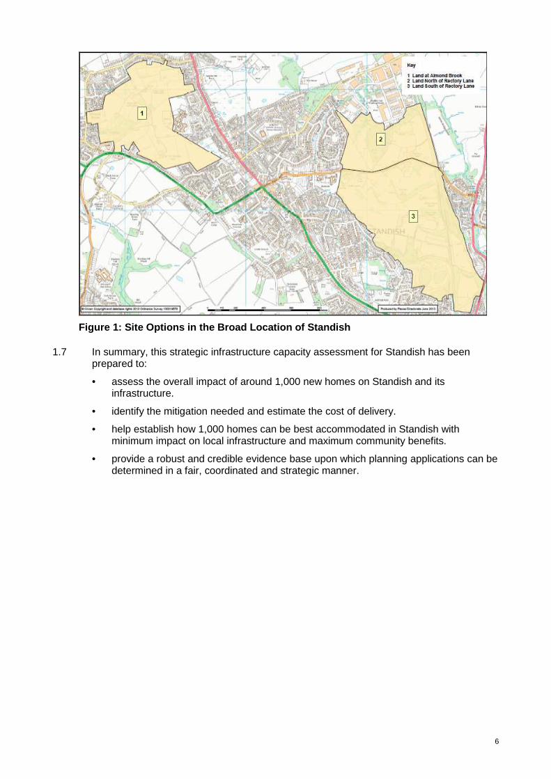
1.5 The areas of safeguarded land from which the 1,000 new homes will be drawn are at Almond Brook and north and south of Rectory Lane. These are shown in Figure 1.
1.6 This infrastructure assessment generally assesses the impact of the following development scenarios:
• Development on land north and south of Rectory Lane, including the land accessed from Chorley Road.
• Development focused at Almond Brook (750 homes) with remaining 250 homes at Rectory Lane.
• Development split equally east-west with 500 homes at Almond Brook and 500 at Rectory Lane/Chorley Road.
6
Figure 1: Site Options in the Broad Location of Sta ndish 1.7 In summary, this strategic infrastructure capacity assessment for Standish has been
prepared to:
• assess the overall impact of around 1,000 new homes on Standish and its infrastructure.
• identify the mitigation needed and estimate the cost of delivery.
• help establish how 1,000 homes can be best accommodated in Standish with minimum impact on local infrastructure and maximum community benefits.
• provide a robust and credible evidence base upon which planning applications can be determined in a fair, coordinated and strategic manner.

7
2 INFRASTRUCTURE
2.1 The following categories of infrastructure are assessed in this document:
• Transport infrastructure; including the impact of development on the highway network, public transport and walking and cycling provision.
• Education infrastructure; specifically the impact of development on primary and
secondary school place provision. • Health infrastructure; the impact of development on the ability of local residents to
access a GP and dental services.
• Open space and recreation
• Community infrastructure (including community facil ities)
• Utilities infrastructure; including gas, electricity, water and sewerage.
8
3 TRANSPORT
3.1 Policy context
3.1.1 Paragraph 32 of the National Planning Policy Framework states that “development should only be prevented or refused on transport grounds where the residual cumulative impacts of development are severe”.
3.1.2 While independent Transport Assessments, submitted as part of planning applications within the broad location, have concluded that proposals taken in isolation will not impact severely on the local transport network, the cumulative impact of 1,000 homes could be, and is likely to be, severe given the overall scale of development and the existing capacity issues in Standish.
3.1.3 The cumulative impact of 1,000 homes is considerably different to the impact of each site in isolation, as each site will each generate traffic onto the same road network and affect capacity at the same junctions. For example, three individual proposals could be deemed to have an insignificant impact on a particular junction when considered in isolation, but cumulatively could render the junction overcapacity and in need of mitigation. It is therefore imperative that the cumulative impact of development on transport infrastructure is considered in the determination of planning applications within the broad location.
3.1.4 Policy CP7 of the Core Strategy sets out a clear commitment to improving accessibility to key destinations by, amongst other things, maximising the use of the existing bus and rail network; developing and enhancing our on and off-road networks for walking and cycling; and maximising the capacity, efficiency and safety of the road network; reducing, as far as is practicable, the adverse impact of transport on our communities, town centres and the wider environment. These principles will be crucial in guiding our approach within the broad location.
3.1.5 Adhering to these principles requires a coordinated approach in which the mitigation measures necessary to address the overall traffic impact are identified, assessed in terms of priority and phased accordingly. To ensure delivery, all developers will be required to make pro-rata financial contributions (per dwelling) towards the delivery of the overall mitigation package needed, regardless of site location or phase of development. This is a fair approach in which all developers contribute evenly to the mitigation of the cumulative impact of the development.
3.2 Mitigating the impact of transport
3.2.1 The Council’s adopted Transport Strategy states that connecting people to places and addressing the barriers that make it difficult for people to move around the borough are fundamental issues when considering the impact of transport. The strategy supports Policy CP7 through the hierarchical approach to identifying and delivering transport improvements; this is discussed later in this section of the report.
3.2.2 We are facing unique and challenging issues in terms of transport and tackling these is critical to the economic, social and environmental wellbeing of our communities, as we rely on our transport networks to provide access to jobs, services, schools and shops, and allows us to make the most of our free time.
3.2.3 Development needs to take place in the right locations to prioritise sustainable travel (by walking, cycling and public transport), and this is particularly important for connections to key destinations such as town centres, schools, community facilities, recreation facilities etc.
9
3.3 Transport Assessment Principles
3.3.1 Key transport assessment principles include:
• Reducing the need to travel in the first place, because it physically removes trips off the network.
• Transferring trips onto sustainable travel choices to improve congestion by moving car based trips to more efficient modes of transport (walking, cycling and public transport) that use less road space and also help with travel costs, health, and climate change.
• Improving the efficiency of the network to minimise the impact from car based trips, including managing driver behaviour (speed limits, traffic calming etc), embracing new economical and technological solutions (including electric vehicles) and improving the network (junction improvements, new highway connections).
3.3.2 When planning permission is granted for each of the housing sites, there will be a condition on the approval which will require the submission and approval of travel plans to detail how the developer intends to minimise the need for travel and prioritise public transport, cycling and walking opportunities.
3.3.3 The choice of transport mode for longer journeys will be influenced by the convenience and cost of public transport choices and its connectivity with the origin and destinations of each trip. Therefore, developers need to recognise the significant role of sustainable travel choices from the outset, to help minimise the impact of transport on the existing infrastructure while providing a balanced approach to the provision of new / improved highway connections.
3.3.4 The council commissioned Transport for Greater Manchester (TfGM) to examine the impact of the 1,000 homes on the local highway network and help assess the strategic infrastructure capacity and necessary highway improvements that will be required. The modelling evidence provided by TfGM is summarised later in this section of the report.
3.4 Transport Baseline: Existing Situation
3.4.1 Standish is the most north western area of the borough and has boundaries with West Lancashire and Chorley in Lancashire. It has a direct connection to the M6 motorway at Junction 27 and to Wigan town centre via the A49 Wigan Road. The West Coast Main Line also runs through the area.
3.4.2 The three areas of safeguarded land in Standish are bounded as follows:
• North of Rectory Lane - bounded by Bradley Hall Trading Estate, Copeland Drive, Avondale Road, B5239 Rectory Lane and the West Coast Main Line.
• South of Rectory Lane - bounded by B5239 Rectory Lane, A5106 Chorley Road and the residential area to the west including Cranleigh.
• Almond Brook - bounded by Pepper Lane, Robin Hill Drive, A49 Preston Road, A5209 Almond Brook Road and the residential area to the south including Langham Road.
3.4.3 Baseline transport evidence and additional information in the Standish area has previously been provided for each of these locations in the Initial Transport Assessment which was submitted as part of the Examination in Public for the Core Strategy. These are appended to this report (refer to Appendix A), and includes:
• existing transport issues (congestion hotspots, rail, bus, walking / cycling; and travel patterns); and
• potential transport interventions / measures.

10
3.5 Sustainable transport improvement measures
3.5.1 Sustainable travel choices are vital in minimising the transport impact from development. In Standish there is evidence that residents can adjust their travel patterns. An initiative led by Wigan Council in 2009 involved more than 800 Standish households taking part in a personalised travel plan study. Walking and cycling to school increased to such an extent that the percentage of pupils being driven to school reduced from 31% to 8%. Car sharing to work increased and use of public transport increased overall.
3.5.2 The following section builds on the initial transport assessment work undertaken and embraces the transport principles set out in this assessment plan in order to help outline and justify the interventions and measures that will be required to minimise the impact from 1,000 units being developed in Standish.
3.5.3 At the end of each section, a high level summary is provided to assess the potential impact for mitigating transport concerns, using the following format:
���� overall positive impact O no impact x overall negative impact
3.6 Walking and cycling
3.6.1 From Figure 2 below, it is evident that there is a higher concentration of Rights of Way (footpaths and bridleways) in the Almond Brook area than the Rectory Lane area. The walking and cycling routes at Almond Brook provide sustainable routes to Preston Road (to connect to high frequency bus services), Standish town centre, Shevington Moor and local schools including Standish Community High School adjacent.
3.6.2 South of Rectory Lane has a Right of Way on the western edge that provides links to St.Wilfrid’s Primary School and via Rectory Lane to Standish town centre. There is also a traffic free bridleway route on the southern edge that links to adjacent residential areas onto the cycle lane facilities on the A49, which connects Standish centre with Wigan Town Centre.
Figure 2: Public Rights of Way Network in the Stan dish Area
3.5.14 There are a number of existing pedestrian and cycling provisions on the adopted highway from all three areas that can be utilised for local trips to key destinations. However the footway provision on Rectory Lane is particularly poor, which is known to create problems
11
for school journeys especially from Chorley Road where there are physical width restrictions at the rail bridge.
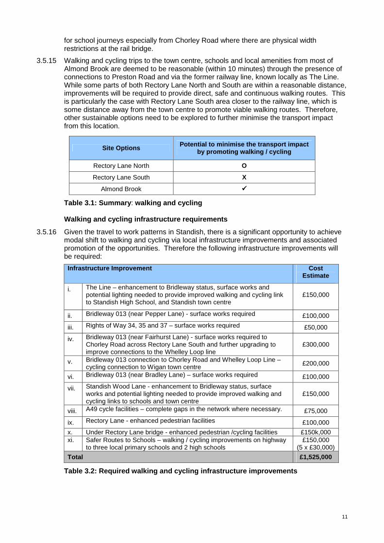
3.5.15 Walking and cycling trips to the town centre, schools and local amenities from most of Almond Brook are deemed to be reasonable (within 10 minutes) through the presence of connections to Preston Road and via the former railway line, known locally as The Line. While some parts of both Rectory Lane North and South are within a reasonable distance, improvements will be required to provide direct, safe and continuous walking routes. This is particularly the case with Rectory Lane South area closer to the railway line, which is some distance away from the town centre to promote viable walking routes. Therefore, other sustainable options need to be explored to further minimise the transport impact from this location.
Site Options Potential to minimise the transport impact by promoting walking / cycling
Rectory Lane North O
Rectory Lane South X
Almond Brook ����
Table 3.1: Summary : walking and cycling Walking and cycling infrastructure requirements
3.5.16 Given the travel to work patterns in Standish, there is a significant opportunity to achieve modal shift to walking and cycling via local infrastructure improvements and associated promotion of the opportunities. Therefore the following infrastructure improvements will be required:
Infrastructure Improvement Cost Estimate
i. The Line – enhancement to Bridleway status, surface works and potential lighting needed to provide improved walking and cycling link to Standish High School, and Standish town centre
£150,000
ii. Bridleway 013 (near Pepper Lane) - surface works required £100,000
iii. Rights of Way 34, 35 and 37 – surface works required £50,000
iv. Bridleway 013 (near Fairhurst Lane) - surface works required to Chorley Road across Rectory Lane South and further upgrading to improve connections to the Whelley Loop line
£300,000
v. Bridleway 013 connection to Chorley Road and Whelley Loop Line – cycling connection to Wigan town centre £200,000
vi. Bridleway 013 (near Bradley Lane) – surface works required £100,000
vii. Standish Wood Lane - enhancement to Bridleway status, surface works and potential lighting needed to provide improved walking and cycling links to schools and town centre
£150,000
viii. A49 cycle facilities – complete gaps in the network where necessary. £75,000
ix. Rectory Lane - enhanced pedestrian facilities £100,000
x. Under Rectory Lane bridge - enhanced pedestrian /cycling facilities £150k,000 xi. Safer Routes to Schools – walking / cycling improvements on highway
to three local primary schools and 2 high schools £150,000
(5 x £30,000)
Total £1,525,000
Table 3.2: Required walking and cycling infrastruc ture improvements
12
3.5.17 The infrastructure improvements for walking and cycling to be required from amongst the schemes listed above is dependant upon the pattern of development that is determined. This is discussed further in the concluding section of this report.
3.6 Public transport: bus connections
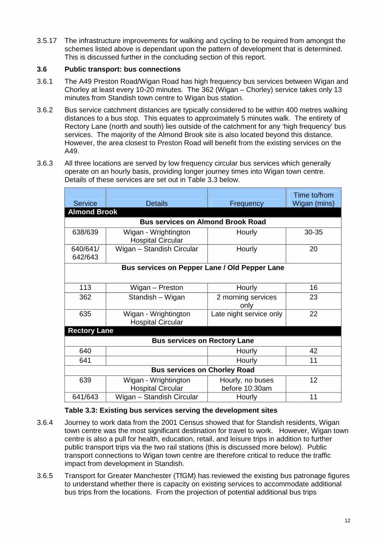
3.6.1 The A49 Preston Road/Wigan Road has high frequency bus services between Wigan and Chorley at least every 10-20 minutes. The 362 (Wigan – Chorley) service takes only 13 minutes from Standish town centre to Wigan bus station.
3.6.2 Bus service catchment distances are typically considered to be within 400 metres walking distances to a bus stop. This equates to approximately 5 minutes walk. The entirety of Rectory Lane (north and south) lies outside of the catchment for any ‘high frequency’ bus services. The majority of the Almond Brook site is also located beyond this distance. However, the area closest to Preston Road will benefit from the existing services on the A49.
3.6.3 All three locations are served by low frequency circular bus services which generally operate on an hourly basis, providing longer journey times into Wigan town centre. Details of these services are set out in Table 3.3 below.
Service Details Frequency Time to/from Wigan (mins)
Almond Brook Bus services on Almond Brook Road
638/639 Wigan - Wrightington Hospital Circular
Hourly 30-35
640/641/ 642/643
Wigan – Standish Circular Hourly 20
Bus services on Pepper Lane / Old Pepper Lane
113 Wigan – Preston Hourly 16 362 Standish – Wigan 2 morning services
only 23
635 Wigan - Wrightington Hospital Circular
Late night service only 22
Rectory Lane Bus services on Rectory Lane
640 Hourly 42 641 Hourly 11
Bus services on Chorley Road 639 Wigan - Wrightington
Hospital Circular Hourly, no buses before 10:30am
12
641/643 Wigan – Standish Circular Hourly 11
Table 3.3: Existing bus services serving the devel opment sites
3.6.4 Journey to work data from the 2001 Census showed that for Standish residents, Wigan town centre was the most significant destination for travel to work. However, Wigan town centre is also a pull for health, education, retail, and leisure trips in addition to further public transport trips via the two rail stations (this is discussed more below). Public transport connections to Wigan town centre are therefore critical to reduce the traffic impact from development in Standish.
3.6.5 Transport for Greater Manchester (TfGM) has reviewed the existing bus patronage figures to understand whether there is capacity on existing services to accommodate additional bus trips from the locations. From the projection of potential additional bus trips
13
generated, TfGM are satisfied that the proposed level of development will not have a significant impact on the capacity of existing bus services.
3.6.6 Nevertheless in order to improve the accessibility of specific development sites; and encourage modal shift to mitigate against additional traffic congestion, it may be necessary to divert existing services, extend hours of operation or provide additional bus services. This will need to be assessed on a site by site basis.
3.6.7 Almond Brook offers the best choice in terms of current bus based public transport frequency and destinations. Rectory Lane North and South offer limited public transport choices in terms of frequency and destinations.
3.6.8 Development at Rectory Lane South would provide an opportunity for the development of a bus-only route accessed from a new bus gate onto Grove Lane. This would incentivise bus use from the site as access to Wigan would be more direct without the need to travel through Standish crossroads or along Rectory Lane / Chorley Road.
3.6.9 Even with new direct bus services to Wigan provided close to Rectory Lane, Almond Brook offers the greatest choice of bus services for future public transport trips to the key travel to work destinations (based upon the 2001 Census) and positive impact upon reducing existing and future private car trips in the area.
Site Options Potential to con nect to existing bus services
Rectory Lane North X
Rectory Lane South X
Almond Brook ����
Table 3.4: Summary - Public transport: bus connec tions
3.6.10 The development of 1,000 additional homes within Standish will clearly place greater importance on the availability of ‘frequent’ bus services to key destinations to attract patronage and reduce car use. Developments at Rectory Lane will require significantly more investment for bus services than the Almond Brook option to ensure the provision is reasonable, suitable and adequate. Specific improvements are listed later in this section of the report.
3.7 Public transport: rail connections
3.7.1 As there is no railway station in Standish; the nearest rail services are at Appley Bridge and Gathurst, which are both commuter stops on the Manchester-Southport line. These stations are 2.5 and 3.3 kilometres from Almond Brook and approximately 4.3 kilometres from Rectory Lane. Both stations provide at least hourly services into Wigan and Manchester on Mondays to Saturdays. There are existing hourly bus services (638/639/640/641) providing direct access from the development sites to these stations.
3.7.2 The current parking availability at each station is set out in Table 3.5.
Rail station Car parking spaces
Cycling facilities
Gathurst 20 4 stands, 5 lockers Appley Bridge 50 0 stands, 5 lockers
Table 3.5: Parking provision at the rail stations
3.7.3 Standish residents (existing and new) can also use the rail services at Wigan North Western and Wigan Wallgate in the town centre. The council is developing proposals with TfGM with a view to delivering the Wigan Transport Hub project (an enhanced interchange facility in the heart of the town centre, combining both rail stations and the bus station). This increases the importance of public transport (bus) connections from
14
Standish, not only for direct employment, education, retail, leisure and health but for connecting journeys to destinations outside of the borough.
3.7.4 Rail service connections to Manchester and Blackpool / Preston are also provided at Horwich Parkway station in Bolton, where there is a significant park and ride facility. There are no direct bus connections to accommodate this linked public transport journey and therefore, this will need consideration to ensure that this gap in provision does not generate additional car based trips.
3.7.5 TfGM have reviewed parking provision at all rail stations in Greater Manchester and those outside that are close to the county boundary. This was a high level screening exercise. At locations where the provision of parking, or the expansion of existing parking capacity, would enable more people to access rail services, a more detailed appraisal will be required to confirm the business case for development.
3.7.6 The screening exercise was based on assessing the site in terms of compatibility with the wider transport network, demand levels, land availability and site access. Both Gathurst and Appley Bridge stations scored very favourably on these criteria. In particular, there was evidence of excess demand at both stations. There is also evidence of additional parking demand from Shevington, whereby informal park and ride / car sharing is taking place having a further impact on all day parking within Shevington.
3.7.7 The distances from the broad location to both Gathurst and Appley Bridge stations from the development sites are too great for walking and cycling to be realistic travel choices. Therefore significant improvement is required in the provision of public transport connections (bus – rail) especially during peak periods, specifically:
• the provision of new direct bus services into Wigan town centre from the development sites (for employment, education, training, health, leisure and for interchange with rail services at Wigan North Western and Wallgate stations);
• the provision of new / enhanced bus service connections to other key destinations including Appley Bridge / Gathurst rail stations and Wrightington Hospital; and
• the promotion of existing bus services. This could include marketing campaigns, and/or the improvement of on-route infrastructure such as new bus shelters and real-time information.
3.7.8 A study was undertaken by Halcrow for Wigan Council and Transport for Greater Manchester in 2012 to understand the feasibility of introducing a rail station in the Standish area on the West Coast Main Line. Results of this study are available on the council’s website and show that there was potential for a new station to be introduced as the proposed service paths for the Liverpool - Blackpool service (post electrification timetable) could potentially accommodate an additional stop should funding (in the region of £10million) be confirmed.
3.7.9 A new station in this location remains an option, but the restricted nature of services which could be available in the medium term would present concerns about operational viability and the opportunities for the station to significant benefit Standish residents in their travel choices.
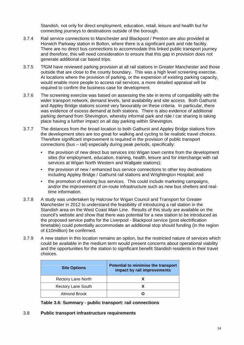
Site Options Potential to minimise the transport impact by rail improvements
Rectory Lane North X
Rectory Lane South X
Almond Brook O
Table 3.6: Summary - public transport: rail connec tions 3.8 Public transport infrastructure requirements

15
3.8.1 Given the travel to work patterns in Standish, there is a significant opportunity to promote and encourage the use of public transport through enhanced provision. Developers will be required to provide or make financial contributions towards improvements to connect the locations to existing rail infrastructure, including:
• New cycle connections to existing train services at Gathurst, Appley Bridge, Wigan town centre and Horwich Parkway stations.
• New or improved bus services to Gathurst, Appley Bridge, Wigan town centre and Horwich Parkway stations.
• Improved parking facilities at Gathurst and Appley Bridge stations with additional consideration for protecting / managing car parks in Standish and Shevington centres.
• Additional measures including discount annual tickets / passes, cycle storage / parking etc will all need to be considered as part of the wider travel plan measures.
Infrastructure Improvement Cost Estimate
Contribution towards improved bus services to:
• Appley Bridge / Gathurst Rail stations
• Wrightington Hospital
• Wigan Town Centre
• Horwich Parkway / Bolton Town Centre
Total – £1,800,000
(£150,000 per new / diverted service per
year for 3 years)
Parking improvements at:
• Appley Bridge rail station
• Gathurst rail station
Total – £300,000
(£150,000 per site)
Parking protection / management at:
• Shevington centre
• Standish centre
Total - £100,000
(£50,000 per site)
TOTAL £2,200,000
Table 3.7: Required bus/rail infrastructure improv ements 3.9 Highways: Existing Conditions
3.9.1 One of the biggest transport issues relating to new development is clearly the impact on the highway network; particularly congestion. Reducing and managing congestion is one of the key priorities for Wigan Council.
3.9.2 Traffic data analysis has, for some time, shown that there are congestion issues in Standish. Current conditions were assessed in spring 2013 using volumetric and queue length surveys at key junctions. These surveys validated traffic issues and quantified the current levels of peak hour congestion and queuing at a number of the key junctions.
3.9.3 Key locations are the signalised crossroads in the town centre, the Wigan Road / Chorley Road junction and the signalised canal bridge on the B5239 at Red Rock to the east of the town. The town centre crossroads is the junction of the A49 Wigan Road and Preston Road with the A5209 School Lane and B5239 Rectory Lane. It is referred to hereafter as Standish crossroads. The junction of the A49 Wigan Road with the A5106 Chorley Road is at Boar’s Head, to the south of the town. It is currently a mini roundabout and is referred to hereafter as the Boar’s Head roundabout or junction. The canal bridge is referred to hereafter as Red Rock canal bridge.
3.9.4 The junctions identified in Table 3.8 are currently operating at, or over, capacity on one or more arms and any additional traffic would only exacerbate these problems. The table indicates whether the additional development traffic is likely to have a minor or major
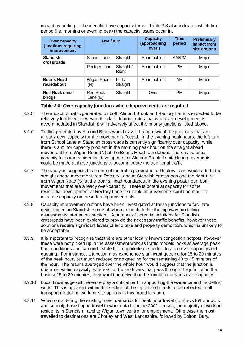
16
impact by adding to the identified overcapacity turns. Table 3.8 also indicates which time period (i.e. morning or evening peak) the capacity issues occur in.
Over capacity junctions requiring
improvement
Arm / turn Capacity
(approaching / over )
Time period
Preliminary impact from site options
School Lane Straight Approaching AM/PM Major Standish crossroads Rectory Lane Straight /
Right Approaching PM
Major
Boar’s Head roundabout
Wigan Road (N)
Left / Straight
Approaching AM
Minor
Red Rock canal bridge
Red Rock Lane (E)
Straight Over PM Major
Table 3.8: Over capacity junctions where improveme nts are required
3.9.5 The impact of traffic generated by both Almond Brook and Rectory Lane is expected to be relatively localised; however, the data demonstrates that wherever development is accommodated in Standish it will adversely affect the priority junctions listed above.
3.9.6 Traffic generated by Almond Brook would travel through two of the junctions that are already over-capacity for the movement affected. In the evening peak hours, the left-turn from School Lane at Standish crossroads is currently significantly over capacity, while there is a minor capacity problem in the morning peak hour on the straight ahead movement from Wigan Road (N) at the Boar’s Head roundabout. There is potential capacity for some residential development at Almond Brook if suitable improvements could be made at these junctions to accommodate the additional traffic.
3.9.7 The analysis suggests that some of the traffic generated at Rectory Lane would add to the straight ahead movement from Rectory Lane at Standish crossroads and the right-turn from Wigan Road (S) at the Boar’s Head roundabout in the evening peak hour; both movements that are already over-capacity. There is potential capacity for some residential development at Rectory Lane if suitable improvements could be made to increase capacity on these turning movements.
3.9.8 Capacity improvement options have been investigated at these junctions to facilitate development in Standish: some of which are included in the highway modelling assessments later in this section. A number of potential solutions for Standish crossroads have been explored to provide the necessary traffic benefits, however these solutions require significant levels of land take and property demolition, which is unlikely to be acceptable.
3.9.9 It is important to recognise that there are other locally known congestion hotpots, however these were not picked up in the assessment work as traffic models looks at average peak hour conditions and can understate the magnitude of shorter duration over-capacity and queuing. For instance, a junction may experience significant queuing for 15 to 20 minutes of the peak hour, but much reduced or no queuing for the remaining 40 to 45 minutes of the hour. The results averaged over the whole hour would suggest that the junction is operating within capacity, whereas for those drivers that pass through the junction in the busiest 15 to 20 minutes, they would perceive that the junction operates over-capacity.
3.9.10 Local knowledge will therefore play a critical part in supporting the evidence and modelling work. This is apparent within this section of the report and needs to be reflected in all transport modelling work for site options in this broad location.
3.9.11 When considering the existing travel demands for peak hour travel (journeys to/from work and school), based upon travel to work data from the 2001 census, the majority of working residents in Standish travel to Wigan town centre for employment. Otherwise the most travelled to destinations are Chorley and West Lancashire, followed by Bolton, Bury,

17
Warrington and St Helens, all outside of the borough. Understanding travel patterns and behaviours will be another critical component to minimising the impact of development.
3.9.12 In 2010, Wigan Council undertook a Congestion Study, which comprised roadside interviews on key corridors across the borough. Analysis of the data from Site Reference 202: A49 Wigan Lane south-east bound (route from Standish into Wigan), located just to the south of the Boar’s Head roundabout, reveals the following:
• Most car drivers travelling through the site during the AM peak period were commuting between their home and workplace. As might be expected the reverse is true for the evening peak with most car drivers travelling from work to home. This supports the 2001 Census information showing that Wigan town centre is a major destination for journeys to work of Standish residents.
• The origin-destination plots show that most car journeys started in Standish and Shevington Moor. Most journeys terminated in Wigan town centre and its surrounding areas and the Robin Park/Martland Park areas
3.9.13 As the 2011 Census information is not yet available for these data sets, the 2010 study helps to validate the trip patterns observed in the 2001 Census.
3.9.14 The count information and trip pattern data does not account for any linked trips, for example, people driving to drop children off at breakfast clubs / school then going onto work, or coming home from work and going to the shops or leisure activities first before going home with multiple trips through junctions unaccounted for and double turning movements. This highlights the importance of ensuring local knowledge is applied to any modelling assessments (which are steered by the data and assumptions input into the system). Modelling evidence is not definitive in isolation.
3.10 Highway Impact Assessments: Traffic Modelling
3.10.1 Wigan Council appointed TfGM’s Highways Forecasting and Analytical Services team (HFAS) to examine the potential traffic impact of an additional 1,000 homes in Standish specifically for this Infrastructure Assessment. A local Saturn model of Standish was developed, cordoned from the base year (validation) Wigan LDF Saturn Model. The extent of the cordoned network for Standish is shown in Figure 3.
Figure 3: TfGM Modelling Cordon
18
3.10.2 The car trip generation of the sites was estimated using the same TRICS1 trip rates used for all traffic modelling carried out in support of the development of the Core Strategy. For the purposes of this work, the trip rates used for the TRICS site location category was ‘edge of town’ and for the TRICS residential land-use category, ‘house privately owned’. We estimated the likely distribution of the trips generated by the potential development sites using the HFAS Devtrips2 software.
3.10.3 Initially (for simplicity) each development site was assumed to have a single access point onto the network: Almond Brook would access from Almond Brook Road between its two junctions with Arbour Lane, and development at Rectory Lane would access onto the midpoint of Rectory Lane. To ensure that all the traffic generated by each site could reach the network, the site access junction was coded into the model with unlimited capacity.
3.10.4 Further modelling assumptions included:
• that individual developers would carry out appropriate assessments of their proposed site access arrangements to ensure that they provide sufficient capacity.
• that there will be no growth in background traffic levels.
• that future traffic growth in the cordoned model areas would be solely due to traffic generated by the proposed development sites.
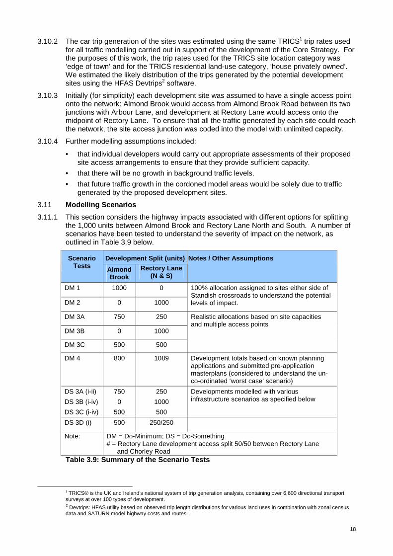
3.11 Modelling Scenarios
3.11.1 This section considers the highway impacts associated with different options for splitting the 1,000 units between Almond Brook and Rectory Lane North and South. A number of scenarios have been tested to understand the severity of impact on the network, as outlined in Table 3.9 below.
Development Split (units) Scenario Tests Almond
Brook Rectory Lane
(N & S)
Notes / Other Assumptions
DM 1 1000 0
DM 2 0 1000
100% allocation assigned to sites either side of Standish crossroads to understand the potential levels of impact.
DM 3A 750 250
DM 3B 0 1000
DM 3C 500 500
Realistic allocations based on site capacities and multiple access points
DM 4 800 1089 Development totals based on known planning applications and submitted pre-application masterplans (considered to understand the un-co-ordinated ‘worst case’ scenario)
DS 3A (i-ii)
DS 3B (i-iv)
DS 3C (i-iv)
750
0
500
250
1000
500
Developments modelled with various infrastructure scenarios as specified below
DS 3D (i) 500 250/250
Note: DM = Do-Minimum; DS = Do-Something # = Rectory Lane development access split 50/50 between Rectory Lane
and Chorley Road Table 3.9: Summary of the Scenario Tests
1 TRICS® is the UK and Ireland’s national system of trip generation analysis, containing over 6,600 directional transport surveys at over 100 types of development. 2 Devtrips: HFAS utility based on observed trip length distributions for various land uses in combination with zonal census data and SATURN model highway costs and routes.

19
3.11.2 DM 1 & DM 2 Scenarios: These examine the potential worst-case impact of development of all 1,000 units on one or other of Almond Brook and Rectory Lane to identify all potential capacity impacts of the generated traffic. The results are summarised in the Table 3.10 below.
Test Over capacity junctions where improvement
required
Arm / Turn Capacity
(Approaching / Over)
Time period
(AM / PM)
School Lane Left / straight Over AM / PM
Rectory Lane Straight / right Over PM
Standish crossroads
Preston Road Right Over PM
DM 1
Boar’s Head roundabout Wigan Road (N) Straight Over AM
School Lane Straight Over AM / PM Standish crossroads
Rectory Lane Straight / right Over PM
DM 2
Boar’s Head roundabout Wigan Road (N) Left Over AM
Note: DM 1 = Full development at Almond Brook (1,000 units)
DM 2 = Full development at Rectory Lane (1,000 units)
Table 3.10: Results summary from DM1 and DM2
3.11.3 DM 1: If the full 1,000 homes were developed at Almond Brook, Standish crossroads would suffer capacity problems, in particular, straight ahead and right-turn movements on the School Lane arm (both peak hours) and on the straight ahead movement on the Rectory Lane arm (evening peak hour). The Boar’s Head roundabout is also forecast to be over-capacity in the morning peak, with the main capacity issues on the straight-ahead and left-turn movements on the Wigan Road (N) arm.
3.11.4 DM 2: If the full 1,000 homes were developed at Rectory Lane, there would still be capacity issues at Standish crossroads, in particular the straight ahead and right-turn movements from Rectory Lane in both peak hours and the straight ahead movement from School Lane. The Boar’s Head roundabout would continue to operate within capacity despite the additional traffic at this junction.
3.11.5 The results of these worst-case scenario tests indicate that there would be severe congestion if development was concentrated either at Almond Brook or Rectory Lane, unless significant interventions were introduced.
3.11.6 Scenarios DM 3A, 3B & 3C: Following the initial impact assessment, more detailed information about site capacities and likely access points were factored into the assessments to provide a more realistic distribution of the development traffic across the networks. Assumed access arrangements for the three locations were as follows:
• Access to the Almond Brook site would be from Almond Brook Road, Old Pepper Lane and Ludlow Street.
• Access to the Rectory Lane (North) site would be from Rectory Lane and Bradley Lane.
• Access to the Rectory Lane (South) site would be from Rectory Lane, Chorley Road and Grove Lane.
3.11.7 For this stage of the impact assessment, the 1,000 units were allocated to the site options based on realistic site capacities as outlined below.
20
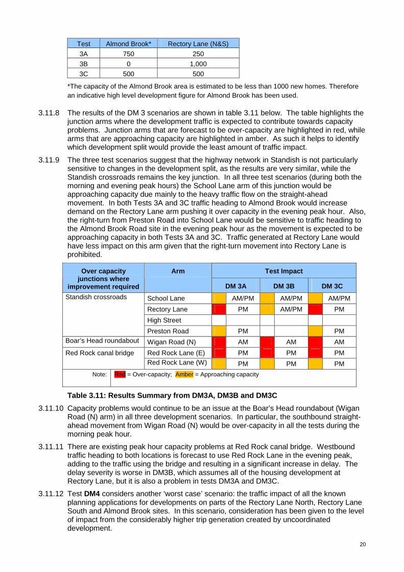
Test Almond Brook* Rectory Lane (N&S)
3A 750 250
3B 0 1,000
3C 500 500
*The capacity of the Almond Brook area is estimated to be less than 1000 new homes. Therefore an indicative high level development figure for Almond Brook has been used.
3.11.8 The results of the DM 3 scenarios are shown in table 3.11 below. The table highlights the junction arms where the development traffic is expected to contribute towards capacity problems. Junction arms that are forecast to be over-capacity are highlighted in red, while arms that are approaching capacity are highlighted in amber. As such it helps to identify which development split would provide the least amount of traffic impact.
3.11.9 The three test scenarios suggest that the highway network in Standish is not particularly sensitive to changes in the development split, as the results are very similar, while the Standish crossroads remains the key junction. In all three test scenarios (during both the morning and evening peak hours) the School Lane arm of this junction would be approaching capacity due mainly to the heavy traffic flow on the straight-ahead movement. In both Tests 3A and 3C traffic heading to Almond Brook would increase demand on the Rectory Lane arm pushing it over capacity in the evening peak hour. Also, the right-turn from Preston Road into School Lane would be sensitive to traffic heading to the Almond Brook Road site in the evening peak hour as the movement is expected to be approaching capacity in both Tests 3A and 3C. Traffic generated at Rectory Lane would have less impact on this arm given that the right-turn movement into Rectory Lane is prohibited.
Test Impact Over capacity junctions where
improvement required
Arm
DM 3A DM 3B DM 3C
School Lane AM/PM AM/PM AM/PM
Rectory Lane PM AM/PM PM
High Street
Standish crossroads
Preston Road PM PM Boar’s Head roundabout Wigan Road (N) AM AM AM
Red Rock Lane (E) PM PM PM Red Rock canal bridge Red Rock Lane (W) PM PM PM
Note: Red = Over-capacity; Amber = Approaching capacity
Table 3.11: Results Summary from DM3A, DM3B and DM3 C
3.11.10 Capacity problems would continue to be an issue at the Boar’s Head roundabout (Wigan Road (N) arm) in all three development scenarios. In particular, the southbound straight-ahead movement from Wigan Road (N) would be over-capacity in all the tests during the morning peak hour.
3.11.11 There are existing peak hour capacity problems at Red Rock canal bridge. Westbound traffic heading to both locations is forecast to use Red Rock Lane in the evening peak, adding to the traffic using the bridge and resulting in a significant increase in delay. The delay severity is worse in DM3B, which assumes all of the housing development at Rectory Lane, but it is also a problem in tests DM3A and DM3C.
3.11.12 Test DM4 considers another ‘worst case’ scenario: the traffic impact of all the known planning applications for developments on parts of the Rectory Lane North, Rectory Lane South and Almond Brook sites. In this scenario, consideration has been given to the level of impact from the considerably higher trip generation created by uncoordinated development.
21
3.11.13 Current known applications and pre-application interests for these areas total just under 1,900 units:
Almond Brook - 800 homes (500 Wainhomes, 300 Bloor)
Rectory Lane – 1,089 homes (309 Himor, 650 Morris & Persimmon, 130 Jones Homes
3.11.14 Clearly, development of this scale would generate considerably more trips than the 1,000 units considered in the tests considered earlier in this report. The test results are outlined in Table 3.11 below.
3.11.15 Test DM4 indicates that the additional development traffic would have a detrimental impact on the performance of all arms of Standish crossroads. In addition to the movements that have capacity problems in the various DM3 scenarios, the left-turn from High Street into School Lane would also be approaching capacity in the morning peak hour. The Red Rock canal bridge would also be severely over capacity in both directions in the evening peak hour. There would also be capacity issues on the Wigan Road (N) arm at the Boar’s Head junction.
Test Impact Over capacity junctions where improvement required
Arm
DM4
School Lane AM/PM
Rectory Lane PM
High Street AM
Standish crossroads
Preston Road PM Boar’s Head roundabout Wigan Road (N) AM
Red Rock Lane (E) PM Red Rock canal bridge Red Rock Lane (W) PM
Note: Red = Over-capacity; Amber = Approaching capacity
Table 3.12: Results Summary from DM4
3.11.16 The modelling of this scenario clearly demonstrates that the significantly higher level of additional traffic generated by all the current planning applications in this area would worsen the capacity problems already identified in the DM3A, DM3B and DM3C scenarios.
3.12 Highway Capacity Improvements
3.12.1 All of the analysis reported above considers the impact of the traffic generated by the developments on the existing highway network in Standish. However, as mentioned earlier, potential mitigation measures have been investigated to help alleviate some of the junction capacity issues identified. These are listed below. Initial scheme drawings can be seen in Appendix D for a number of these proposed measures.
• New link road through Almond Brook between A5209 Almond Brook Road (east of its junction with Arbour Lane) and A49 Preston Road (via Pepper Lane), with strategic junctions at both ends
• New junction layout at the Boar’s Head junction – roundabout replacement by traffic signal control to help regulate peak hour demands and to prioritise / manage queue lengths
• New link road sections through Rectory Lane North and South connecting Rectory Lane with Grove Lane, and/or Chorley Road, and/or Bradley Lane, with associated strategic junctions and capacity improvements.
• Signal management at the Red Rock canal bridge junction
22
• Improvements to Standish crossroads, including an additional left-turn filter lane from Rectory Lane to High Street
• New bypass to the west of Standish between A5209 Crow Orchard Road (at M6 Junction 27) and A49 Wigan Road at Boars Head.
3.12.2 Those potential improvement schemes above that are deemed viable have been added to the scenario tests already examined above (DM 3A, DM 3B, DM 3C), resulting in a set of Do-Something (DS) test scenarios. Improvements to Standish crossroads and the Standish bypass are considered to be unviable and have therefore not been taken forward into the DS test scenarios.
3.12.3 While improvements to Standish crossroads would provide improved traffic flow at this key junction, it would involve a significant amount of property demolition and would subsequently have a damaging impact on the town centre and conservation area. The Standish bypass is a major scheme with a significant cost. While it may provide some relief to Standish crossroads it could significantly increase congestion at the Boars Head junction and on Wigan Lane.
3.12.4 In response to likely viability concerns with the Rectory Lane / Chorley Road link road arising from scenario results with 500 units accessed from Rectory Lane, a further scenario DS 3D has also been developed. This provides an opportunity to understand the impact from 500 units at Rectory Lane with split development access points and without the benefit of internal link road connections.
3.12.5 The set of Do-Something scenarios with the associated combination of mitigation measures are set out in Table 3.13 below:
Test DS 3A DS 3B DS 3C DS 3D
(i)
• Traffic signals at Boars Head roundabout
• Rectory Lane to Chorley Road link only (no link to Grove Lane)
• Traffic signals at Boars Head roundabout
• Signal management at Canal / Red Rock Lane
• Link road from Almond Brook Road to Preston Road
• Link road from Rectory Lane to Grove Lane only
• Traffic signals at Boars Head roundabout
• Signal management at Canal / Red Rock Lane
• Link road from Almond Brook Road to Preston Road
• Link road from Rectory Lane to Grove Lane only
• Traffic signals at Boars Head roundabout
• Signal management at Canal / Red Rock Lane
(ii)
• Link road from Almond Brook Road to Preston Road
• Traffic signals at Boars Head roundabout
• Rectory Lane to Chorley Rd link (under railway) & Grove Lane link
• Traffic signals at Boars Head roundabout
• Signal management at Canal / Red Rock Lane
• Link road from Almond Brook Road to Preston Road
• Traffic signals at Boars Head roundabout
• Signal management at Canal / Red Rock Lane
(iii) • Rectory Lane
to Grove Lane link (without
• Rectory Lane to Grove Lane link only
• Traffic signals at
23
link to Chorley Road)
• Traffic signals at Boars Head roundabout
• Signal management at Canal / Red Rock Lane
Boars Head roundabout
• Signal management at Canal / Red Rock Lane
(iv)
• As 3b(ii) but including longer link road from Bradley Lane to Chorley Road link (under railway)
• Rectory Lane to Bradley Lane link only (no links to Chorley Road or Grove Lane)
• Link road from Almond Brook Road to Preston Road
• Traffic signals at Boars Head roundabout
• Signal management at Canal / Red Rock Lane
Table 3.13: Do-something (DS) interventions for ea ch scenario test
3.12.6 The results of the Standish ‘Do-Something’ test scenarios indicate that generally the network would operate satisfactorily regardless of the development split between the Almond Brook and Rectory Lane sites, particularly in the morning peak hour. The capacity problems at the Boar’s Head roundabout would be mitigated by introducing traffic signals at this junction (based on a preliminary layout and signal staging for the junction provided by GMUTC). Standish crossroads would operate within capacity in some, but not all scenarios. The full set of scenario test results are outlined in Table 3.14.
24
Test Impact
DS3A DS3B DS3C DS3D
Over capacity junctions
where improvement
required
Arm
(i) (ii) (i) (ii) (iii) (iv) (i) (ii) (iii) (iv) (i)
School Lane AM/PM AM AM/PM AM/PM PM
Rectory Lane PM PM PM PM PM
High Street AM
Standish crossroads
Preston Road
Wigan Road (N)
Chorley Road Boar’s Head junction
Wigan Road (S)
Red Rock Lane (E) PM PM PM PM PM PM PM PM PM PM PM Red Rock canal bridge Red Rock Lane (W) PM PM PM PM PM PM PM PM PM PM PM
Red = Over-capacity; Amber = Approaching capacity
Standish development split
DS 3A = 750 Almond Brook Rd; 250 Rectory Lane
DS 3B = 1,000 Rectory Lane; 0 Almond Brook Rd
DS 3C = 500 Almond Brook Rd; 500 Rectory Lane
DS 3D = 500 Almond Brook Rd; 250 Rectory Lane; 250 Chorley Road
Table 3.14: Results Summary for Do-Something Scena rios
25
3.12.7 DS3A(i-ii): The results of test DS3A(i) (750 at Almond Brook; 250 at Rectory Lane) suggest that with no mitigation measures other than at the Boars Head roundabout, there would be expected to be capacity issues at Standish crossroads. In particular, it would be over-capacity on the Rectory Lane arm in the evening peak hour,, and approaching capacity on the School Lane arm at both peaks and the High Street arm at the evening peak.. The Red Rock canal bridge would operate over-capacity in both directions on Red Rock Lane in the evening peak hour. In test DS3A(ii) Standish crossroads would be approaching capacity on the Rectory Lane arm (straight-ahead movement). This scenario indicates that traffic heading towards the land at Almond Brook Road from the east would contribute to the capacity problems on Rectory Lane in the evening peak.
3.12.8 DS3B(i-iv): The mitigation measures in tests DS3B(i) and DS3B(ii) (1,000 at Rectory Lane) appear to alleviate potential capacity problems at Standish crossroads on all the turns used by development traffic. In test DS3B(iii) the School Lane arm of this junction would be the only arm approaching capacity in the morning peak, suggesting that the link road between Rectory Lane and Grove Lane is sufficient to mitigate most of the capacity problems at this junction. Test DS3B(iv) also shows that the School Lane arm of the junction would also be approaching capacity in both peaks, suggesting that the longer link road from Chorley Road through to Bradley Lane would provide no additional benefit to junction performance in the area.
3.12.9 DS3C(i-iv): In tests DS3C(i), DS3C(ii) and DS3C(iii) (500 at Almond Brook; 500 at Rectory Lane) Standish crossroads would be approaching capacity or over-capacity on the Rectory Lane arm (straight-ahead movement). It would also be approaching capacity on the School Lane arm in test DS3C(iii). In test DS3C(iv) the network is expected to perform reasonably well, although the School Lane arm at the crossroads would have capacity concerns in the evening peak hour (with the signals optimised). This test confirms that the new link from Almond Brook Road to Preston Road would help to alleviate the capacity problems at Standish crossroads. The test without the link road (DS3C(iii)) shows that there would be capacity problems at this junction. Traffic flows on the link road between Rectory Lane and Bradley Lane would be relatively light and would be mainly for local access.
3.12.10 DS3D(i): This test (500 at Almond Brook; 250 accessed from Rectory Lane; 250 accessed from Chorley Road) suggests that 500 units can be supported on the Rectory Lane site options, provided that the total number of units accessing Rectory Lane are limited with the remainder accessed from Chorley Road.
3.12.11 In all the test scenarios there would remain capacity problems at the Red Rock Lane / canal bridge traffic signals in the evening peak despite optimising the green time to favour the peak traffic flow direction, because the opposing flow would still be relatively high. Further mitigation would be needed to resolve these capacity issues.
3.13 Conclusions: transport infrastructure assessments:
3.13.1 Highways : The results of the scenario assessments suggest that the critical junction in capacity terms would be Standish crossroads signals. The detailed impact assessments indicate that this junction is particularly sensitive to traffic generated by both Almond Brook and Rectory Lane, with capacity problems primarily on the Rectory Lane and School Lane arms in all of the DM tests. The major capacity improvements that could be introduced at this junction involve significant property demolition and are unlikely to be acceptable. Therefore alternative infrastructure proposals have been considered to relieve the transport impact on this junction.
3.13.2 The DS mitigation tests indicate that generally the network would operate satisfactorily regardless of the development split between the Almond Brook and Rectory Lane sites (particularly in the morning peak hour). Standish crossroads would operate satisfactorily in the DS3B scenario (1,000 homes at Rectory Lane), while the DS3A (750 homes at Almond Brook) and DS3C (500 homes at Almond Brook) scenarios indicate that the Almond Brook link road would alleviate most problems at this junction.

26
3.13.3 Test DS3D(i) (500 at Almond Brook; 250 at Rectory Lane; and an indicative 250 at Chorley Road) demonstrated that splitting access points for the Rectory Lane development between Rectory Lane and Chorley Road would mean that the traffic generated by a 500 unit development on the site would have no detrimental impact on the operation of Standish crossroads (with the signal timings optimised).
3.13.4 There would be some deterioration in the performance of the Boar’s Head roundabout (Wigan Road (N) arm) in all of the DM and DS tests without mitigation measures. In particular, the southbound straight-ahead movement from the Wigan Road (N) arm would be over-capacity in the morning peak in all scenarios. The DS tests indicate that the proposed mitigation measure of introducing traffic signal controls at the junction would mitigate against the impact of the additional development traffic.
3.13.5 Capacity problems were also identified at the traffic signals controlling the shuttle-working at the Red Rock canal bridge, with delays for westbound traffic heading to both Almond Brook and Rectory Lane in the evening peak. In the DS test scenarios there would remain capacity problems at these signals despite optimising the green time to favour the peak traffic flow direction, because the flow in the opposite direction is relatively high. Further mitigation will be needed to resolve these capacity issues.
3.13.6 With the additional sustainable transport benefits associated with the Almond Brook site option, in order to minimise the traffic impact of introducing 1,000 units in the Standish area, the evidence suggests that the following combination of site options would be most acceptable in terms of impact on transport infrastructure and the ability for the impact of the cumulative housing development to be mitigated: 500 Almond Brook and 500 Rectory Lane (with an ideal indicative split of 250 off Rectory Lane itself and 250 off Chorley Road).
27
4 EDUCATION
4.1 Primary Schools
4.1.1 There are three primary schools in Standish: St Wilfrid’s CE, Wood Fold Community and St Marie’s RC. They are shown in Figure 4 below. However, for residents in the Chorley Road area, Woodfield Community Primary School on Wigan Lane is the nearest school. Nevertheless, due to popularity of this school and the distance involved, it is unlikely that Standish children would be successful in gaining admission.
Figure 4: Location of schools in Standish
4.1.2 Information on rolls and capacity at these schools are shown in Table 4.1. This shows that there are currently 116 surplus primary school places across these three schools.
Primary School Total no. on roll
Net capacity
Surplus places
% Surplus places
Standish St Wilfrid’s CE 429 500 71 14.20 Wood Fold Community 365 417 52 12.47 St Marie’s Catholic 187 180 -7 -3.89 TOTAL 981 1097 116 9.54
Table 4.1: Surplus places at local primary schools , January 2013
4.1.3 Taking into account published admission numbers and projected primary pupil numbers across each school year, by 2016/17 there is an estimated surplus of 87 places in Standish.
4.1.4 1,000 additional homes would yield in the region of 210 new primary pupils in Standish. This is derived from a standard assumption that 100 homes will yield 3 additional pupils per school year group, therefore 21 in total. Set against the projected surplus of 87 places in 2016/17, there would be a shortfall of 123 places. This is set out in Table 4.2.
28
R Y1 Y2 Y3 Y4 Y5 Y6 TOTAL Standish Primaries 149 163 146 162 138 147 148 1053 Total admission numbers 160 160 160 160 165 165 165 1135 Total Primary Surplus 11 0 14 0 27 18 17 87 Additional places due to development 30 30 30 30 30 30 30 210 Shortfall due to development 19 30 16 30 3 12 13 123
Source: Birth rate statistics, ONS Table 4.2: Projected primary pupil numbers 2016/201 7
4.1.5 As the projected shortfall in some year groups exceeds 15 places (half form entry), an additional 1-form entry primary school or equivalent would be needed to address the shortfall. The cost of a new 1-form entry primary school or equivalent provision is estimated at £3 million (excluding land cost).
4.1.6 Developers will be required to contribute towards the provision of these places. To calculate contributions for education provision the council currently uses the latest DFE cost multipliers published in 2008, reduced by the location factor for Wigan. This currently equates to a cost of £10,664 per primary place. An inflation figure of 3% is then applied. The following equation will therefore be applied to calculate the required financial contribution from each development within the broad location:
[(DFE cost multiplier x Shortfall of places due to devt.) + 3%] x Homes proposed 1000
4.1.7 Based on the existing DFE cost multiplier, this equates to a contribution of £1,351 per dwelling, subject to inflation. This financial contribution applies at the time the homes are built. At current process around £1.35m would be accrued towards the additional school provision.
4.1.8 Approximately 1.5 hectares would need to be safeguarded for the provision of a new primary school. The location of the school needs to take into account its potential to become a Community Hub, so its development would be better suited at the heart of the development rather than on the fringe. There should be good access by public transport, walking and cycling, but it would preferably be located not on a main road to reduce vehicle-pedestrian conflict and the impact of parked cars. The site should ideally be flat, unconstrained and enable school field provision on greenfield land.
4.2 Secondary Schools
4.2.1 Applying the equivalent standard formula for secondary schools, it is estimated that 1,000 new homes will yield around 150 secondary pupils in Standish. Both Standish and Shevington High Schools serve the area. As set out in Table 4.3 below, there is sufficient secondary school capacity, notably at Shevington High School, to address development of this scale.
Secondary School Total no. on roll
Net capacity
Surplus places
% Surplus places
Standish Community High School 1233 1250 17 1.36 Shevington High School 645 890 245 27.53 Total 1878 2140 262 12.24
Table 4.3: Surplus places at local secondary school s, January 2013

29
4.2.2 Development at Almond Brook would provide an opportunity to create a new main entrance and vehicular access to Standish High School. This would be at the west of the school accessed from new roads as part of the development. Existing vehicular access to the school is poor via a narrow residential street. This creates amenity issues and traffic problems at school drop off/pick up times. Development at Almond Brook would also provide an opportunity to improve walking and cycling access from residential areas to Shevington High School.
30
5 HEALTH
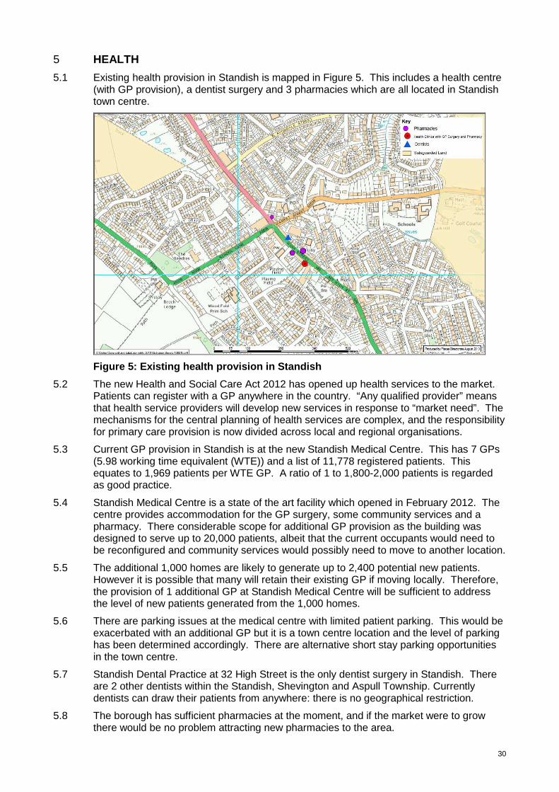
5.1 Existing health provision in Standish is mapped in Figure 5. This includes a health centre (with GP provision), a dentist surgery and 3 pharmacies which are all located in Standish town centre.
Figure 5: Existing health provision in Standish
5.2 The new Health and Social Care Act 2012 has opened up health services to the market. Patients can register with a GP anywhere in the country. “Any qualified provider” means that health service providers will develop new services in response to “market need”. The mechanisms for the central planning of health services are complex, and the responsibility for primary care provision is now divided across local and regional organisations.
5.3 Current GP provision in Standish is at the new Standish Medical Centre. This has 7 GPs (5.98 working time equivalent (WTE)) and a list of 11,778 registered patients. This equates to 1,969 patients per WTE GP. A ratio of 1 to 1,800-2,000 patients is regarded as good practice.
5.4 Standish Medical Centre is a state of the art facility which opened in February 2012. The centre provides accommodation for the GP surgery, some community services and a pharmacy. There considerable scope for additional GP provision as the building was designed to serve up to 20,000 patients, albeit that the current occupants would need to be reconfigured and community services would possibly need to move to another location.
5.5 The additional 1,000 homes are likely to generate up to 2,400 potential new patients. However it is possible that many will retain their existing GP if moving locally. Therefore, the provision of 1 additional GP at Standish Medical Centre will be sufficient to address the level of new patients generated from the 1,000 homes.
5.6 There are parking issues at the medical centre with limited patient parking. This would be exacerbated with an additional GP but it is a town centre location and the level of parking has been determined accordingly. There are alternative short stay parking opportunities in the town centre.
5.7 Standish Dental Practice at 32 High Street is the only dentist surgery in Standish. There are 2 other dentists within the Standish, Shevington and Aspull Township. Currently dentists can draw their patients from anywhere: there is no geographical restriction.
5.8 The borough has sufficient pharmacies at the moment, and if the market were to grow there would be no problem attracting new pharmacies to the area.
31
6 OPEN SPACE AND RECREATION
6.1 Introduction
6.1.1 The addition of 1,000 new homes in Standish will have a significant impact on open space and play provision. Existing provision will come under increased pressure and improvements and new open space and recreational facilities will need to be secured. There will need to be provision in the new housing areas, wherever they are located, and the opportunities that those sites offer will need to be maximised. Equally there is a need to consider the green and recreational links between the new housing sites and existing facilities and services. There is also a need to protect and enhance the ecological and biodiversity value of the area. Overall it needs to be considered in a strategic and co-ordinated way.
6.1.2 At a minimum, all development within the broad location will be required to contribute towards the provision of open space and recreation in accordance with saved Unitary Development Plan Policy R1E and the associated Open Space in New Developments Supplementary Planning Document (October 2013).
6.1.3 The policy requires developers of schemes that exceed 99 dwellings to provide a total amount of public open space equivalent to a minimum of 25 sq m per dwelling and a financial contribution in lieu of play equipment provision and to cover commuted maintenance costs. For schemes below 99 dwellings, developers are required to make a financial contribution to the capital and commuted maintenance costs of off-site amenity open space and play space provision proportionate with the number of units in the scheme, in-lieu of on-site provision.
6.1.4 However, because of the significant scale of development, there must be a co-ordinated approach beyond the normal application of planning policy standards and requirements. There are numerous opportunities within and alongside the areas of safeguarded land or, like Ashfield Park, elsewhere within Standish to which there are existing or potential strategic links. These would enhance opportunities in Standish. Key features are mapped in Figure 6.1. The level of contribution in addition to the standard requirement set by Policy R1E will be negotiable.
6.1.5 The key strategic opportunities in Standish include:
• Improvements to the facilities at Ashfield Park • An upgrade of The Line to enhance east-west connectivity • Increased allotment provision • Improvements to areas of semi-natural greenspace, including the former Victoria and
part of the Robin Hill Colliery sites and Barrowcroft Wood • A new Local Nature Reserve • Enhancements, and improved links, to the former Whelley Loop Line • New play pitch provision • Provision for children and young people
6.1.6 These opportunities are set out in more detail in the remainder of this section. It is not anticipated that developer contributions will enable the delivery of all the opportunities identified. However, it is important that the new developments are integrated effectively and sustainably into the settlement with sustainable access to areas of quality open space, key services and amenities.
32
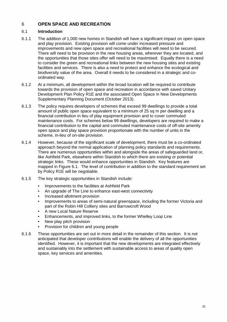
Figure 6: Open space provision in Standish 6.2 Ashfield Park
6.2.1 Ashfield Park is the main park in Standish, located to the south of the settlement. It has an area of 9 hectares and is identified as a Township Park in the Local Plan Core Strategy. Township parks are intended to serve catchment areas of 1,200 metres. Therefore it would serve the Rectory Lane / Chorley Road development sites adequately but not Almond Brook.
The park has a range of play provision together with playing pitches, woodland and general amenity greenspace areas. Part is designated locally as an historic park and garden. There is potential to improve the quality of the facilities including the existing play equipment and the four playing pitches which have drainage issues (covered in the playing pitch provision section below). There is also a deficiency in that there are no changing facilities serving the playing pitches despite their use by a number of amateur football teams. There is also scope to enhance the footpath link with the nearby recreation area at the former Victoria Colliery, which is currently poorly maintained.
6.3 The Line
6.3.1 The former mineral railway line, known locally as ‘The Line’, is a key footpath route connecting Standish town centre, the former Robin Hill Colliery, amenity greenspace at Woodhurst Drive, the Primrose Lane Site of Biological Importance, Shevington Moor and Standish High School. It provides a ‘safe walking route to school’ from surrounding residential areas and also links to other north-south footpaths providing access between Robin Hill Lane and Cat I’th’ Window Farm. A section of The Line adjacent to the town centre off School Lane is in private ownership having been lost to a garden extension in the 1980s. This makes access at this western end less direct than it would have been.
6.3.2 The Line, which runs broadly east-west across Almond Brook, is an important route and development at that location provides an excellent opportunity to upgrade it to bridleway/cycleway status, improve landscaping, and enhance connectivity within Standish. There would also be an opportunity to secure the land in private ownership thereby enhancing the connectivity of the route. Development at Almond Brook provides an opportunity to incorporate elements of improvement to The Line as part of the development.
33
6.3.3 The potential improvements to The Line are estimated to cost in the region of £250,000.
6.4 Allotment provision
6.4.1 Within Standish there are currently 0.38 hectares of private allotment provision (about 15 plots) at Old Beechfield Gardens, adjacent to St Marie’s Church. There are no Council owned allotments.
6.4.2 The Wigan Allotment Strategy sets a target of achieving 9.4 plots per 1,000 households. Against this there is clearly a deficit of in Standish. In accordance with the target, 1,000 homes will generate the need for an additional 2,350sqm of allotment provision (based on a plot size of 250sqm). This should all be provided in one location either as a new site or as an extension to the existing provision at Old Beechfield Gardens. Developers will be required to provide allotments on-site or make a financial contribution towards this provision. This level of provision is estimated to cost in the region of £30,000. Therefore developers who do not provide on-site allotment provision will be required to contribute £30 per dwelling.
6.5 Areas of natural and semi-natural greenspace
6.5.1 Natural and semi-natural greenspace can be found at several sites throughout Standish, including the former Victoria and Robin Hill Colliery sites, Barrowcroft Wood and numerous Sites of Biological Importance.
6.5.2 The former Victoria and Robin Hill Colliery sites were reclaimed in the 1980s to create areas of publicly accessible greenspace including meadowland, ponds, reed beds and woodland. Both areas are located close to potential development sites and therefore play an important role in terms of providing a green network. Both areas have potential for enhancement, particularly with regard to drainage and access. Robin Hill Colliery site has some potential for development and not all of it may be required for open space if other parts of it are enhanced. The Victoria site has particularly poor access from the north and a poorly maintained link to Ashfield Park to the west, which is in private ownership. Footpaths in both locations can become impassable in winter.
Improvement Estimated cost
Cost per dwelling
Victoria Colliery Woodland management £25,000 £25 New/reinstate drainage £4,000 £4 Reinstate footpaths £22,500 £22.50 Improve access to/from north to bridleway standard £14,700 £14.70 Additional furniture £10,000 £10 Purchase footpath link to Ashfield Park £20,000 £20 TOTAL £96,700 £96.70 Robin Hill Colliery Woodland management £10,000 £10 Pond improvements £15,000 £15 Footpath restoration £6,000 £6 Additional furniture £8,000 £8 TOTAL £39,000 £39
Table 6.1: Potential improvements to areas of natur al and semi-natural greenspace
6.5.3 Barrowcroft Wood, north of Rectory Lane, is a Site of Biological Importance. In addition to its ecological value it contains a number of munitions testing magazines that date back to the role of the Bradley Hall site during the Second World War. It has no public access currently but has potential to be established as a community resource, particularly if land to the north of Rectory Lane is developed for housing.
6.5.4 There are other Sites of Biological Importance and areas of mature woodland, including the ponds at Robin Hill Farm West and Primrose Hill, which are both located within or adjacent to Almond Brook, and woodland at Fairhurst Lane, Kitchen Carr Wood and Otter Close Wood, which are located at Rectory Lane. There is scope to enhance these areas,
34
through appropriate woodland management and pond improvements, as part of the developments.
6.6 Local Nature Reserves
6.6.1 Based on the Natural England recommendation of 1 hectare per 1,000 people, there is an identified boroughwide deficit of Local Nature Reserves totalling 36 hectares. The Core Strategy supports the designation of additional Local Nature Reserves. In line with the Natural England recommendation, the development of 1,000 homes equates to the provision of an additional 2.4 hectares of Local Nature Reserve. There is scope to designate areas within the Haigh Country Park or at Worthington Lakes, or more locally at one of the sites of biological importance identified at paragraphs 6.1.17 and 6.1.18. Contributions to the requirements for Local Nature Reserve status at one of more of these areas may be appropriate.
6.7 Former Whelley Loop Line
6.7.1 Part of the former ‘Whelley Loop Line’ bounds Chorley Road and offers scope for improvements to the walking, cycling and bridleway network to link residential development off Rectory Lane with the former Victoria Colliery. This area contains large areas of natural woodland which would benefit from management and has drainage issues. There is scope to address these issues through development at Rectory Lane.
6.8 Playing pitch provision
6.8.1 Saved policy C1B of the Wigan Unitary Development Plan sets local standards for the provision of football and rugby pitches in the borough as follows:
Pitch size Football Rugby Mini 1 per 14,000 population 1 per 15,000 population Junior 1 per 5,500 population 1 per 14,000 population Senior 1 per 4,500 population 1 per 9,000 population
Table 6.2: Local playing pitch standards
6.8.2 Existing pitch provision in Standish consists of:
• 2 junior football pitches at Ashfield Park • 6 senior football pitches, including 2 at Ashfield Park, 2 at Standish Community High
School, and one each at The Convent and Southlands Avenue. • 1 senior rugby pitch at Standish Community High School.
6.8.3 There are also mini and junior pitches at Woodfold and St Marie’s primary schools, however these are not accessible to the public and therefore do not contribute towards the standards.
6.8.4 Based upon the local standards, there is an overall deficit of approximately 1 pitch to meet the needs of the existing population of 14,037, and a deficit of approximately 3 pitches against the projected need following the development. This is set out in Table 6.3 below.
Surplus deficit Pitch size
Need based on existing population
Need based on projected population
Current provision Current
population Future
population Football Mini 1.00 1.17 0 -1.00 -1.17 Junior 2.55 2.99 2 -0.55 -0.99 Senior 3.12 3.65 6 2.88 2.35 Rugby Mini 0.94 1.10 0 -0.94 -1.10 Junior 1.00 1.17 0 -1.00 -1.17 Senior 1.56 1.83 1 -0.56 -0.83 Combined total -1.17 -2.91
Table 6.3: Quantitative assessment of need of pitc h provision in Standish
35
6.8.5 Table 6.3 shows that there is in fact a surplus of over 2 senior football pitches, but a deficit of all other pitch types and sizes. This could be addressed by remarking existing senior pitches to accommodate mini and junior football and rugby.
6.8.6 A number of the existing pitches are in poor condition and do not meet current sporting needs, particularly at Ashfield Park, The Convent and Southlands Avenue. The poor condition of these pitches is predominantly as a result of poor drainage. Improving the quality of these pitches is our priority and developer contributions will be focused towards this accordingly.
6.8.7 The estimated cost of undertaking these improvements and the financial contribution that will be required from developers is set out in Table 6.4 below. The required financial contribution from developers is based on the developers contributing 14.6% towards these overall improvements. This is the anticipated increase in population in Standish as a result of the development of 1000 homes.
Required from developer Improvement Current
pitch condition
Estimated cost to improve Total
(16.5% of cost)
Per dwelling
4 pitches at Ashfield Park Poor £200,000 £29,200 £29.20 1 pitch at Southlands Avenue Poor £50,000 £7,300 £7.30 1 pitch at The Convent Poor £50,000 £7,300 £7.30 Total £300,000 £43,800 £43.80
Table 6.4: Estimated costs of required playing pitc h improvements
6.8.8 This identifies a required financial contribution of £43.80 per dwelling from developers towards pitch improvements
6.8.9 Other outdoor sports facilities include one private cricket pitch and 3 private bowling greens and other private sports pitches. It is considered that these facilities are sufficient to meet current and future requirements.
6.8.10 We are currently undertaking a qualitative assessment of open space in the borough, including playing pitches. This assessment will be completed to inform the Allocations Development Plan Document. The findings of the assessment could have an impact on the contributions sought from developers towards playing pitch provision.
36
7 COMMUNITY INFRASTRUCTURE
7.1 Standish Community Centre is located at Moody Street, off Church Street in the town centre. This is a small centre for a settlement the size of Standish and there is little scope for expansion due to the constrained site and the built up area. Facilities at the centre would benefit from modernisation, particularly the kitchen, toilets and flooring, and the small car park also requires resurfacing.
7.2 In addition to the community centre, there is a wide and diverse range of other facilities which provide rooms or services for community use such as schools, churches and the library. Typical community uses include:
• health and fitness classes such as zumba, line dancing, martial arts, table tennis and badminton;
• Weight Watchers • Mother and baby groups • Youth groups including beavers, cubs, scouts, rainbows, brownies and guides • Card games e.g. whist and bridge • Prayer groups
Schools and children’s centres
7.3 As set out in section 4, there are 3 primary schools and one high school in Standish (with Shevington High School close by). Many of these provide access for community use and promote community services and events. In particular Standish Community High School provides for a range of activities. There are no Sure Start Children’s Centres in Standish - the nearest are at Shevington and Aspull.
Places of worship
7.4 There are three places of worship:
• St Wilfrid’s Church of England, Market Place • St Marie’s Roman Catholic Church, Almond Brook Road • Standish Methodist Church, High Street
7.5 These churches have facilities available for community use, including church halls.
7.6 St Wilfrid’s Parish Hall is a good quality modern community facility built in 1999. It has four community rooms which range in size, including a large hall which can seat around 120. The hall is used daily by a wide range of community groups and organisations. To meet community demands, the hall would benefit from a modernised kitchen, refurbished toilet facilities, and a resurfaced car park.
7.7 St Marie’s Parish Hall has 2 large rooms for community use. Both rooms have kitchen facilities and are regularly used for parish functions and by community groups including brownies, guides and rainbows, an over 60s group, and health and fitness classes. They are also often rented for parties. Both rooms have been refurbished recently but the hall would benefit from double glazing on the ground floor.
7.8 Standish Methodist Hall has two community rooms (the main hall and the back hall) which are widely used for community uses. It is an old building and would benefit from maintenance and improved facilities including roof repairs, an upgraded kitchen, and a resurfaced car park. They also have aspirations to take over the land to the rear of the church for additional parking and a play area to meet the needs of youth groups.
Libraries
7.9 There is one library at Cross Street, Standish. This provides a community room and promotes community services and events.
Other facilities
7.10 There are also many independently run facilities which may have an incidental community use or an associated recreational use that will provide a room for community use or

37
functions and otherwise provide a community service. These include pubs, social clubs, hotels/restaurants and Standish Cricket Club.
7.11 Community facilities are predominantly located in Standish town centre. They are mapped in Figure 7.
Figure 7: Existing community facilities in Standish
Conclusion
7.12 Quantitatively, community provision in Standish is well provided for with a wide range of facilities available as identified above. However, a number of these facilities would benefit from modernisation, refurbishment and general maintenance to meet the needs of the community and maintain a sufficient community offer. However, as the majority of the facilities are managed and maintained independently by the community, access to funding to make these improvements is generally limited.
7.13 Given that the new developments will increase the demand for these facilities, developers will be required to make a financial contribution of £100 per dwelling to support the improvement and maintenance of community provision in Standish. This will help to sustain community infrastructure in the locality.

38
8 UTILITIES INFRASTRUCTURE
8.1 There is sufficient water infrastructure surrounding all sites that will support the
development, but there will be a requirement for minimal intervention depending on point of connection.
8.2 There are known sewerage issues at Cranleigh and Rectory Lane. Development north
and south of Rectory Lane and on Chorley Road would have to feed into Chorley Road pumping station which is already a high risk site. The Almond Brook area is served by two pumping stations at Arbour Lane and Chorley Road but these have existing overloading issues.
8.3 With regard to gas, it is unlikely that the development of around 1,000 homes in Standish
will create capacity issues for National Grid on any of the development sites. The existing transmission networks should be able to cope with additional demands.
8.4 Spare electricity capacity is not currently available in Standish as at 2013. Approved
schemes in the Electricity North West programme will increase capacity to adequate levels by 2015.
39
9 CONCLUSIONS
9.1 The assessment has concluded that the impact of development on the local transport network, including highways, public transport and walking and cycling, is the most fundamental consideration when determining how development should be distributed across Standish. The impacts on other elements of infrastructure are less geographical specific and do not change fundamentally wherever development is located within the broad location.
9.2 Section 3 confirms that, in transport terms, development is best distributed with around 500 homes at Almond Brook and around 500 homes at Rectory Lane; with a maximum of 250 homes accessed from Rectory Lane and the remainder from Chorley Road. This is subject to the provision of significant new transport interventions delivered by the developments or by financial contributions from the developers as appropriate.
9.3 Based on this preferred pattern of distribution, the assessment indicates that the following mitigation measures will be required to minimise the impact of the developments on the local transport network:
• Link road from Almond Brook Road to Preston Road (incorporated into the Almond Brook developments) with associated new junctions at Almond Brook Road and Ludlow Street or Pepper Lane
• Link road from Rectory Lane to Grove Lane with associated new junctions and potential bus gate at Grove Lane (should development be approved on the south side of Rectory Lane)
• Traffic signals at Boars Head roundabout
• Signal management at Red Rock Lane / canal bridge
• New and improved walking and cycling infrastructure
• New and improved bus and rail infrastructure
9.4 Most infrastructure requirements other than transport can be met through financial contributions based upon the number of homes proposed (a cost per dwelling). They are not influenced by where in Standish development will take place. Examples include contributions towards education, health and community provision.
9.5 In terms of open space this assessment has identified some particular local priorities which may be opportunities for investment dependent on where development takes place. A number of these opportunities have the potential to be incorporated into schemes such as investment in The Old Line and the former Robin Hill Colliery as part of development at Almond Brook.
9.6 The impact of development on the landscape, settlement pattern and urban sprawl are other key determining factors when considering planning applications. Development should, as far as possible, be contiguous and well integrated with the existing built-up area. For example, development along Rectory Lane should be developed west to east with minimal gaps in the built form. Development on Rectory Lane closest to the town centre in principle provides for a more sustainable impact than development further away as it more easily enables walking and cycling to the town centre, local services and schools. The same principle applies to the Almond Brook area. The overall development should be built in a coordinated and strategic manner, with each separate development contributing to the whole effectively. Developers need to work together to achieve this. Detached and disconnected proposals will not be acceptable.
9.7 Other non-infrastructure related factors which will influence decisions on planning applications include:
• Site hazards and constraints including Tree Preservation Orders; ecological factors, areas at risk of flooding; the need to preserve the “best and most versatile” agricultural land; and contamination
40
• The merit of individual schemes and proposals, in terms of design, layout, density, amenity and community benefits associated with them
• The ability of the development to provide sustainable urban extensions to Standish.
9.8 Section 106 contributions will be sought from developers to ensure that the necessary infrastructure mitigation can be provided. Some elements within the sites will come forward as part of development proposals as that development takes shape such as the necessary link roads though a development. Other, mainly off site or strategic works (e.g open space improvement) will need to be provided through applying a section 106 contribution requirement to the individual developments based upon a rate per house.
9.9 The table in Appendix A provide a list of infrastructure works referred to in this assessment. Some of these works are such that a pro-rata contribution per dwelling will be required. Most transport infrastructure and all of the education contribution are in this category. Other contributions will be sought, and drawn from the list, depending upon size, location and nature of the proposal.
9.10 A worked example is also included at Appendix B. This is indicative only and relates to just one scenario (500 homes at Almond Brook and 500 at Rectory Lane, split between Rectory Lane and Chorley Road). It takes some pro-rata contributions and draws some other infrastructure works considered to be necessary for that particular scheme. Although purely an example, the calculation indicates a cost per dwelling of around £5,000.
9.11 The worked example is illustrated at Appendix C. The development areas shown are indicative only and do not reflect the boundaries of existing or anticipated specific planning applications.

41
APPENDICES

42

43
Appendix A: Estimated costs of all identified infra structure schemes
Infrastructure scheme Estimated cost
Contribution sought
Contributions required from:
Comments
Walking and cycling Enhance The Line to Bridleway status, surface works and potential lighting.
£150,000 £150,000 Almond Brook
Bridleway 013 (near Pepper Lane) - surface works required £100,000 £100,000 Almond Brook Public Rights of Way 34, 35 and 37 – surface works required £50,000 £50,000 Almond Brook Bridleway 013 (near Fairhurst Lane) - surface works required to Chorley Road across Rectory Lane South and further upgrading to improve connections to the Whelley Loop line
£300,000 £300,000 Rectory Lane
Bridleway 013 connection to Chorley Road and Whelley Loop Line – cycling connection to Wigan town centre
£200,000 £200,000 Rectory Lane
Bridleway 013 (near Bradley Lane) – surface works required £100,000 £100,000 Rectory Lane Standish Wood Lane - enhancement to Bridleway status, surface works and potential lighting needed to provide improved walking and cycling links to schools and town centre
£150,000 £150,000 All areas
A49 cycle facilities – complete gaps in the network where necessary.
£75,000 £75,000 All areas
Rectory Lane - enhanced pedestrian facilities £100,000 £100,000 Rectory Lane Under Rectory Lane bridge - enhanced pedestrian /cycling facilities £150,000 £150,000 Rectory Lane
Walking and cycling
Safer Routes to Schools – walking / cycling improvements on highway to three local primary schools and 2 high schools
£150,000 £150,000 All areas £30,000 per school
Bus/rail infrastructure Improvement to bus services to Appley Bridge / Gathurst rail stations
£450,000 £450,000 All areas £150,000 per service per year for 3 years
Improvement to bus services to Wrightington Hospital £450,000 £450,000 All areas £150,000 per service per year for 3 years
Improvement to bus services to Wigan town centre £450,000 £450,000 All areas £150,000 per service per year for 3 years
Improvement to bus services to Horwich Parkway / Bolton Town Centre
£450,000 £450,000 All areas £150,000 per service per year for 3 years
Parking improvements at Appley Bridge rail station £150,000 £150,000 All areas Parking improvements at Gathurst rail station £150,000 £150,000 All areas Parking protection / management at Shevington centre £50,000 £50,000 All areas
Bus / rail infrastructure
Parking protection / management at Standish centre £50,000 £50,000 All areas Highways Canal/Red Rock Red Rock canal bridge junction - Signal management (peak hour
priority) £100,000 £100,000 All areas
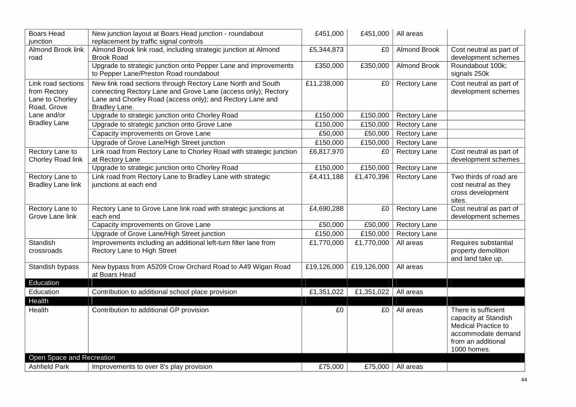
44
Boars Head junction
New junction layout at Boars Head junction - roundabout replacement by traffic signal controls
£451,000 £451,000 All areas
Almond Brook link road, including strategic junction at Almond Brook Road
£5,344,873 £0 Almond Brook Cost neutral as part of development schemes
Almond Brook link road
Upgrade to strategic junction onto Pepper Lane and improvements to Pepper Lane/Preston Road roundabout
£350,000 £350,000 Almond Brook Roundabout 100k; signals 250k
New link road sections through Rectory Lane North and South connecting Rectory Lane and Grove Lane (access only); Rectory Lane and Chorley Road (access only); and Rectory Lane and Bradley Lane.
£11,238,000 £0 Rectory Lane Cost neutral as part of development schemes
Upgrade to strategic junction onto Chorley Road £150,000 £150,000 Rectory Lane Upgrade to strategic junction onto Grove Lane £150,000 £150,000 Rectory Lane Capacity improvements on Grove Lane £50,000 £50,000 Rectory Lane
Link road sections from Rectory Lane to Chorley Road, Grove Lane and/or Bradley Lane
Upgrade of Grove Lane/High Street junction £150,000 £150,000 Rectory Lane Link road from Rectory Lane to Chorley Road with strategic junction at Rectory Lane
£6,817,970 £0 Rectory Lane Cost neutral as part of development schemes
Rectory Lane to Chorley Road link
Upgrade to strategic junction onto Chorley Road £150,000 £150,000 Rectory Lane Rectory Lane to Bradley Lane link
Link road from Rectory Lane to Bradley Lane with strategic junctions at each end
£4,411,188 £1,470,396 Rectory Lane Two thirds of road are cost neutral as they cross development sites.
Rectory Lane to Grove Lane link road with strategic junctions at each end
£4,690,288 £0 Rectory Lane Cost neutral as part of development schemes
Capacity improvements on Grove Lane £50,000 £50,000 Rectory Lane
Rectory Lane to Grove Lane link
Upgrade of Grove Lane/High Street junction £150,000 £150,000 Rectory Lane Standish crossroads
Improvements including an additional left-turn filter lane from Rectory Lane to High Street
£1,770,000 £1,770,000 All areas Requires substantial property demolition and land take up.
Standish bypass New bypass from A5209 Crow Orchard Road to A49 Wigan Road at Boars Head
£19,126,000 £19,126,000 All areas
Education Education Contribution to additional school place provision £1,351,022 £1,351,022 All areas Health Health Contribution to additional GP provision £0 £0 All areas There is sufficient
capacity at Standish Medical Practice to accommodate demand from an additional 1000 homes.
Open Space and Recreation Ashfield Park Improvements to over 8's play provision £75,000 £75,000 All areas
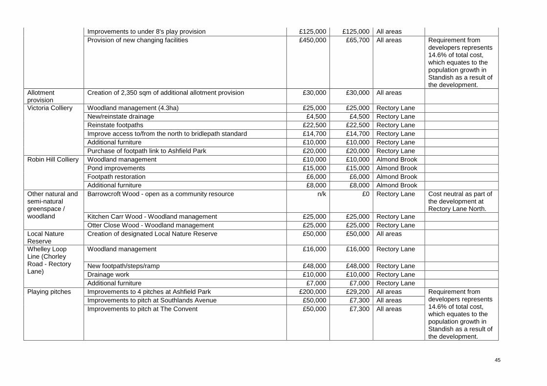
45
Improvements to under 8's play provision £125,000 £125,000 All areas Provision of new changing facilities £450,000 £65,700 All areas Requirement from
developers represents 14.6% of total cost, which equates to the population growth in Standish as a result of the development.
Allotment provision
Creation of 2,350 sqm of additional allotment provision £30,000 £30,000 All areas
Woodland management (4.3ha) £25,000 £25,000 Rectory Lane New/reinstate drainage £4,500 £4,500 Rectory Lane Reinstate footpaths £22,500 £22,500 Rectory Lane Improve access to/from the north to bridlepath standard £14,700 £14,700 Rectory Lane Additional furniture £10,000 £10,000 Rectory Lane
Victoria Colliery
Purchase of footpath link to Ashfield Park £20,000 £20,000 Rectory Lane Woodland management £10,000 £10,000 Almond Brook Pond improvements £15,000 £15,000 Almond Brook Footpath restoration £6,000 £6,000 Almond Brook
Robin Hill Colliery
Additional furniture £8,000 £8,000 Almond Brook Barrowcroft Wood - open as a community resource n/k £0 Rectory Lane Cost neutral as part of
the development at Rectory Lane North.
Kitchen Carr Wood - Woodland management £25,000 £25,000 Rectory Lane
Other natural and semi-natural greenspace / woodland
Otter Close Wood - Woodland management £25,000 £25,000 Rectory Lane Local Nature Reserve
Creation of designated Local Nature Reserve £50,000 £50,000 All areas
Woodland management £16,000 £16,000 Rectory Lane
New footpath/steps/ramp £48,000 £48,000 Rectory Lane Drainage work £10,000 £10,000 Rectory Lane
Whelley Loop Line (Chorley Road - Rectory Lane)
Additional furniture £7,000 £7,000 Rectory Lane Improvements to 4 pitches at Ashfield Park £200,000 £29,200 All areas Improvements to pitch at Southlands Avenue £50,000 £7,300 All areas
Playing pitches
Improvements to pitch at The Convent £50,000 £7,300 All areas
Requirement from developers represents 14.6% of total cost, which equates to the population growth in Standish as a result of the development.
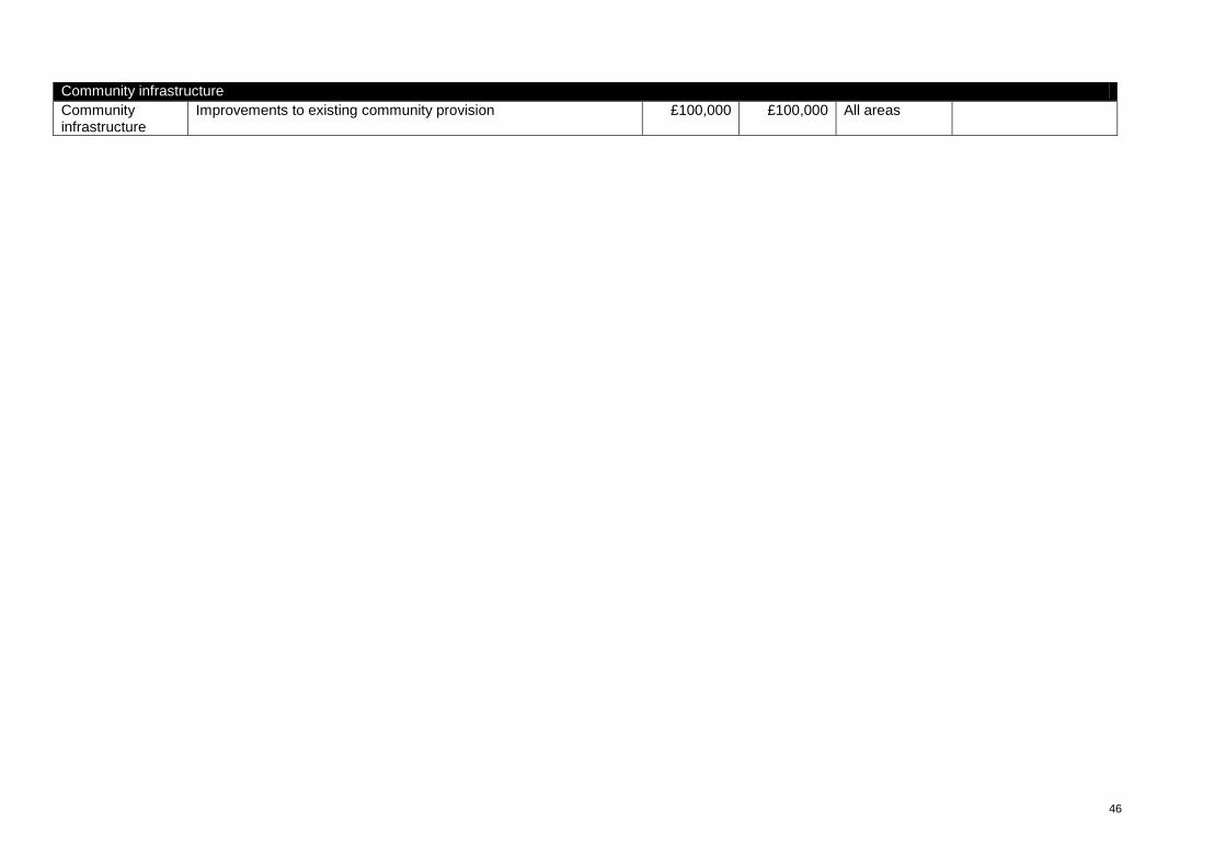
46
Community infrastructure Community infrastructure
Improvements to existing community provision £100,000 £100,000 All areas
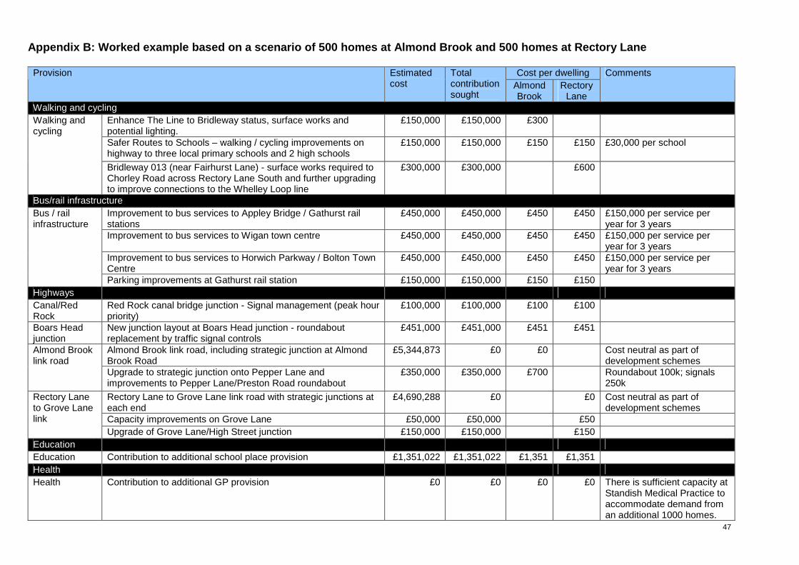
47
Appendix B: Worked example based on a scenario of 5 00 homes at Almond Brook and 500 homes at Rectory L ane
Cost per dwelling Provision Estimated cost
Total contribution sought
Almond Brook
Rectory Lane
Comments
Walking and cycling Enhance The Line to Bridleway status, surface works and potential lighting.
£150,000 £150,000 £300
Safer Routes to Schools – walking / cycling improvements on highway to three local primary schools and 2 high schools
£150,000 £150,000 £150 £150 £30,000 per school
Walking and cycling
Bridleway 013 (near Fairhurst Lane) - surface works required to Chorley Road across Rectory Lane South and further upgrading to improve connections to the Whelley Loop line
£300,000 £300,000 £600
Bus/rail infrastructure Improvement to bus services to Appley Bridge / Gathurst rail stations
£450,000 £450,000 £450 £450 £150,000 per service per year for 3 years
Improvement to bus services to Wigan town centre £450,000 £450,000 £450 £450 £150,000 per service per year for 3 years
Improvement to bus services to Horwich Parkway / Bolton Town Centre
£450,000 £450,000 £450 £450 £150,000 per service per year for 3 years
Bus / rail infrastructure
Parking improvements at Gathurst rail station £150,000 £150,000 £150 £150 Highways Canal/Red Rock
Red Rock canal bridge junction - Signal management (peak hour priority)
£100,000 £100,000 £100 £100
Boars Head junction
New junction layout at Boars Head junction - roundabout replacement by traffic signal controls
£451,000 £451,000 £451 £451
Almond Brook link road, including strategic junction at Almond Brook Road
£5,344,873 £0 £0 Cost neutral as part of development schemes
Almond Brook link road
Upgrade to strategic junction onto Pepper Lane and improvements to Pepper Lane/Preston Road roundabout
£350,000 £350,000 £700 Roundabout 100k; signals 250k
Rectory Lane to Grove Lane link road with strategic junctions at each end
£4,690,288 £0 £0 Cost neutral as part of development schemes
Capacity improvements on Grove Lane £50,000 £50,000 £50
Rectory Lane to Grove Lane link
Upgrade of Grove Lane/High Street junction £150,000 £150,000 £150 Education Education Contribution to additional school place provision £1,351,022 £1,351,022 £1,351 £1,351 Health Health Contribution to additional GP provision £0 £0 £0 £0 There is sufficient capacity at
Standish Medical Practice to accommodate demand from an additional 1000 homes.
48
Open Space and Recreation Improvements to under 8's play provision £125,000 £125,000 £125 £125 Ashfield Park Provision of new changing facilities £450,000 £65,700 £66 £66 Requirement from
developers represents 14.6% of total cost, which equates to the population growth in Standish as a result of the development.
Allotment provision
Creation of 2,350 sqm of additional allotment provision £30,000 £30,000 £30 £30
Woodland management (4.3ha) £25,000 £25,000 £50 New/reinstate drainage £4,500 £4,500 £9 Reinstate footpaths £22,500 £22,500 £45 Improve access to/from the north to bridlepath standard £14,700 £14,700 £29 Additional furniture £10,000 £10,000 £20
Victoria Colliery
Purchase of footpath link to Ashfield Park £20,000 £20,000 £40 Woodland management £10,000 £10,000 £20 Pond improvements £15,000 £15,000 £30 Footpath restoration £6,000 £6,000 £12
Robin Hill Colliery
Additional furniture £8,000 £8,000 £16 Other natural and semi-natural greenspace / woodland
Barrowcroft Wood - open as a community resource n/k £0 £0 Cost neutral as part of the development at Rectory Lane North.
Woodland management £16,000 £16,000 £32 Drainage work £10,000 £10,000 £20
Whelley Loop Line (Chorley Road – Rectory Lane)
Additional furniture £7,000 £7,000 £14
Improvements to 4 pitches at Ashfield Park £200,000 £29,200 £29 £29 Improvements to pitch at Southlands Avenue £50,000 £7,300 £7 £7
Playing pitches
Improvements to pitch at The Convent £50,000 £7,300 £7 £7
Requirement from developers represents 14.6% of total cost, which equates to the population growth in Standish as a result of the development.
Community infrastructure Community infrastructure
Improvements to existing community provision £100,000 £100,000 £100 £100
£4,995 £4,976
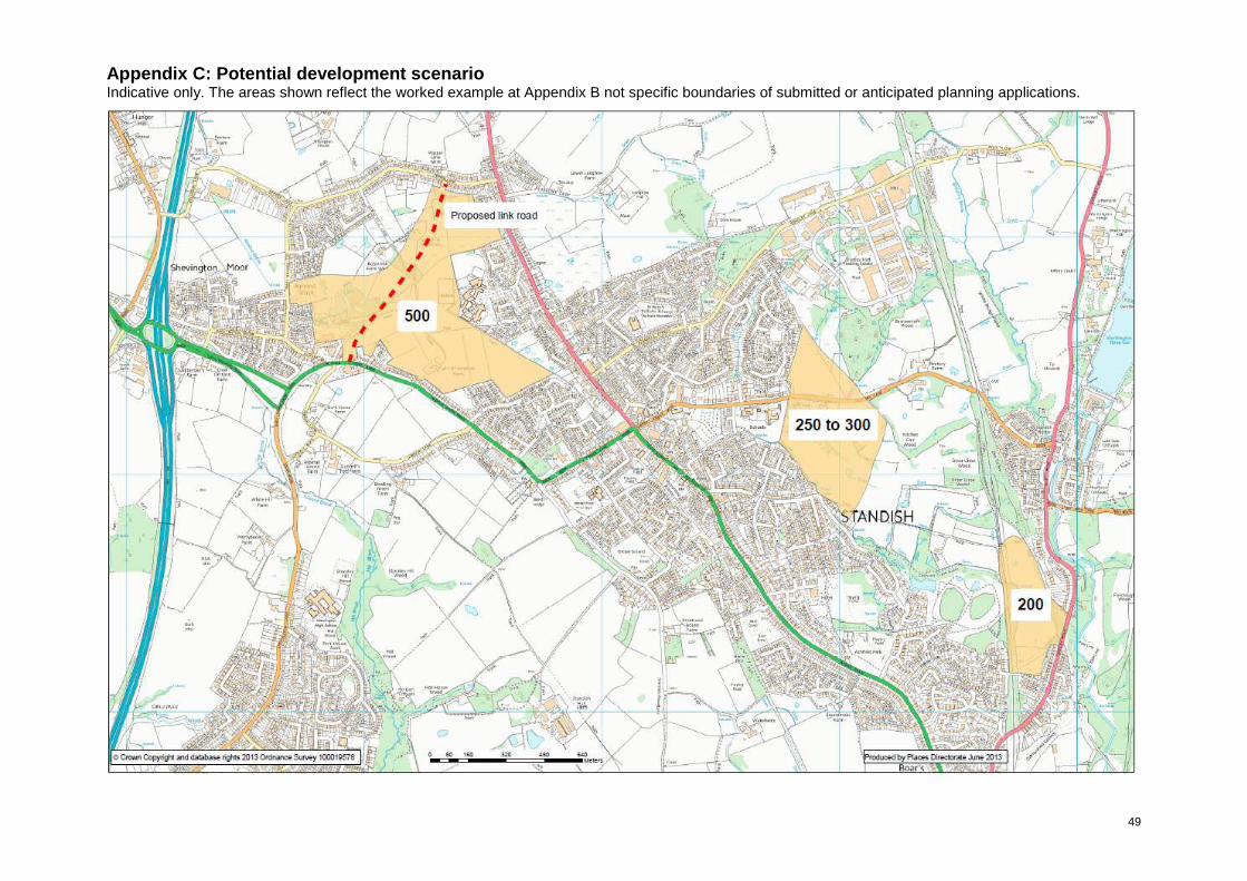
49
Appendix C: Potential development scenario Indicative only. The areas shown reflect the worked example at Appendix B not specific boundaries of submitted or anticipated planning applications.

50

51
Appendix D Initial Highway Scheme Drawings (Standish)
(Indicative only for the purposes of feasibility)
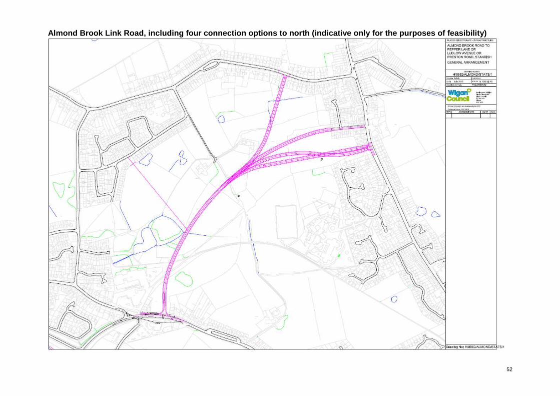
52
Almond Brook Link Road, including four connection o ptions to north (indicative only for the purposes o f feasibility)
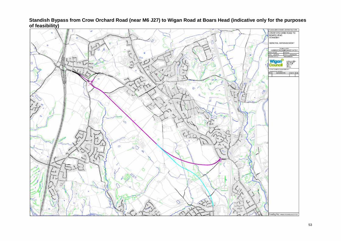
53
Standish Bypass from Crow Orchard Road (near M6 J27 ) to Wigan Road at Boars Head (indicative only for the purposes of feasibility)

54
Link road sections through development sites at Rec tory Lane connecting Rectory Lane with Grove Lane, Chorley Road & Bradley Lane (indicative only for the purposes of f easibility)
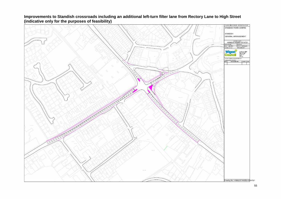
55
Improvements to Standish crossroads including an ad ditional left-turn filter lane from Rectory Lane to High Street (indicative only for the purposes of feasibility)
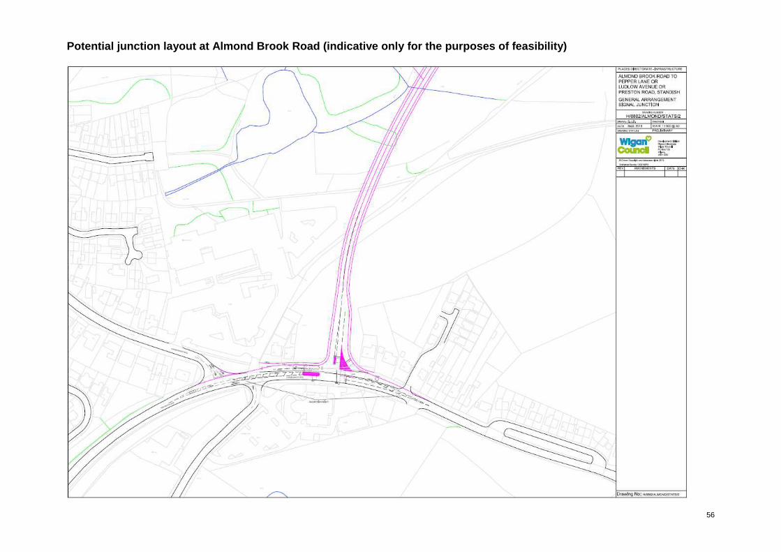
56
Potential junction layout at Almond Brook Road (ind icative only for the purposes of feasibility)
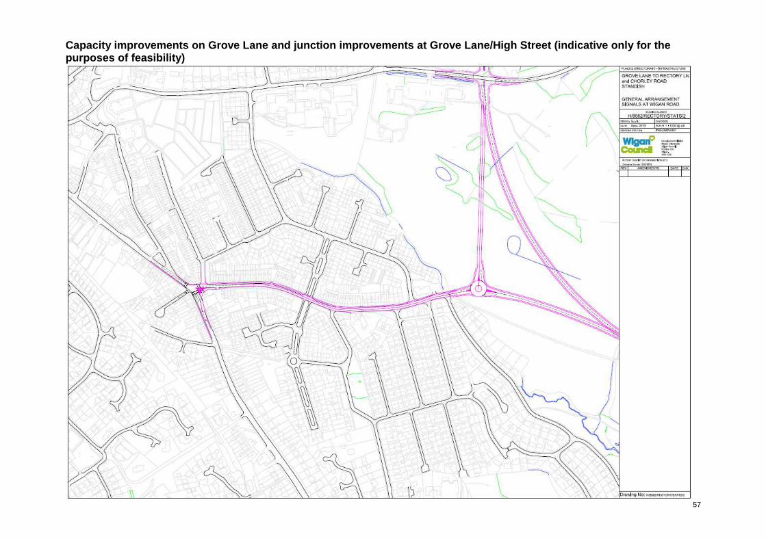
57
Capacity improvements on Grove Lane and junction im provements at Grove Lane/High Street (indicative on ly for the purposes of feasibility)
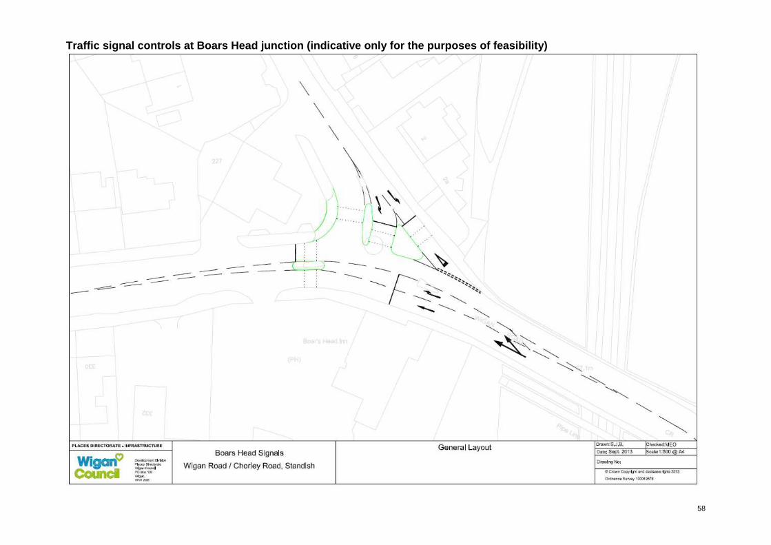
58
Traffic signal controls at Boars Head junction (ind icative only for the purposes of feasibility)