stanza stones - ilkley literature festival
TRANSCRIPT

STANZA STONES POETRY TRAIL GUIDEMarsden to IlkleyShort family walks and 47 mile trail
Guide by Tom LonsdalePoetry by Simon Armitage

The Stanza Stones TeamSimon Armitage PoetPip Hall LettercarverTom Lonsdale Landscape ArchitectWayne Hart Apprentice to Pip Hall
Rachel Feldberg Project DirectorGlenis Burgess Project Manager
Staff of Ilkley Literature FestivalNick Ferguson Stone Waller
Stanza Stones is a collaboration between imove, Ilkley Literature Festival, Simon Armitage and Pennine Prospects.
First published in Great Britain in 2012 by Ilkley Literature Festival.
Copyright © Ilkley Literature Festival. www.ilkleyliteraturefestival.org.uk
Tom Lonsdale has asserted his right under the Copyright, Designs and Patents Act, 1988 to be identified as the author of this work.
All rights reserved. Apart from any fair dealing for the purpose of private study, research, criticism or review, as permitted under the Copyright, Designs and Patents Act, 1988, no part of this publication may be reproduced, stored in a retrieval system, or transmitted in any form or by any means, electronic, electrical, chemical, mechanical, optical, photocopying, recording or otherwise, without the prior written permission of the copyright owner.
ISBN 978-0-9572349
WELCOME
Welcome to this Trail Guide, which offers a choice of ways to access Simon Armitage’s wonderful Stanza Stones poems and the drama and beauty of the Pennine Watershed landscape which inspired them.
I have had a great time devising these routes and I hope you’ll find plenty to delight and inspire you, whether you are just out for a day visit or on a serious trek.
Tom Lonsdale
Consultant Landscape Architect, Stanza Stones
Cover main photo: Pule Hill Quarry,
Marsden Inset: Snow Stone.
STANZA STONES POETRY TRAIL GUIDE
2
INT
RO
DU
CT
ION

FOREWORD BY SIMON ARMITAGE
For many thousands of years people have been coming to moors around West Yorkshire to offer their prayers and express their desires in the form of carved stones. The Stanza Stones poems are my contribution to that unbroken and ongoing dialogue, and consist of six carved poems sited across the South Pennine Watershed, all celebrating or paying their respects to the element which gave shape and form to this region, namely water. The water that sculpted the valleys, the water that powered the industries, the water we take for granted but which is our most precious life-giving substance.
Each carved poem describes water in one of its many forms, hence a Beck Stone, a Puddle Stone, a Mist Stone, a Rain Stone and a Dew Stone. The Snow Stone, the first to be carved, is situated in an old quarry on Pule Hill above the village of Marsden where I was born and grew up.
In my experience the moors are both brutal and blissful, an essential part of our ecology, economy, our vocabulary and our subconscious. So as well as being landmarks in their own right, I hope the Stanza Stones act as beacons of inspiration, encouraging people to engage with West Yorkshire and Lancashire’s great outdoors in thought, word and deed.
And those looking hard enough might stumble across a seventh Stanza Stone, a secret stone left in an unnamed location within the Watershed area, waiting to be discovered and read.
Simon Armitage
ABOUT THE STANZA STONES PROJECTIn 2010 Ilkley Literature Festival and imove began a unique and ambitious project: commissioning leading UK poet, Simon Armitage, to create a series of poems responding to the landscape of the Pennine Watershed in the run up to the London 2012 Olympic and Paralympic Games.
The Festival asked lettercarver Pip Hall and her apprentice Wayne Hart to carve Simon’s poems in six atmospheric locations along the Watershed from Marsden, where Simon was born to Ilkley, the home of Ilkley Literature Festival.Each stone took weeks with Pip spending
days out on the moors. At each end of the Trail, on Pule Hill and Ilkley Moor, local drystone waller Nick Ferguson created a Poetry Seat – where you can sit and admire the view or even write your own poem. Both these initiatives were supported by Pennine Prospects, a South Pennines rural regeneration company.
We’ve had a fantastic 18 months creating the Trail - including working with some very exciting young writers (see page 37) – and we hope you’ll enjoy it as much as we have!
Rachel Feldberg,
Director, Ilkley Literature Festival
STANZA STONES POETRY TRAIL GUIDE
3
INT
RO
DU
CT
ION

The Stanza Stones Trail has been designed with lots of options in mind. From an afternoon walk with the family – perhaps incorporating a visit to the Brontë Parsonage Museum at Howarth www.bronte.info; the canal centre in Marsden www.standedge.co.uk; or a chance to explore the picturesque towns of Ilkley or Hebden Bridge – to a challenging 47 mile trek across glorious wild countryside for experienced walkers.
Short Family Walks pages 6–23The first part of this booklet details short walks to each of the Stanza Stones and back, none of them lasting longer than 50 minutes in total, with details of parking and nearby tea shops, pubs and toilets.
The Stanza Stones are in open country with some rough, muddy ground so you’ll need sensible footwear. The weather can change very quickly, it can be bitterly cold even on a summer’s day so always take waterproofs and an extra fleece.
AccessFor a family group with young children and anyone with more limited mobility, the Rain Stone at Cow’s Mouth Quarry is along a flat, level, gravelled (not loose) track accessible for buggies and wheelchair users. The Puddle Stones, although high and windswept, are reached along a generally level path with some flag stones and the Dew Stones are a gentle walk through grassland and forest.
The Beck Stone on the outskirts of Ilkley is reached along narrow footpaths, not suitable for buggies or wheelchair users. Access to the Snow Stone is up a steep hill while the Mist Stone is over a stile and up a rough track.
The Full Trail in three legs pages 24–36The whole Trail can be tackled in three separate ‘legs’ – Marsden to Hebden Bridge 18.4 miles; Hebden to Bingley 14.5 miles and Bingley to Ilkley 14.1 miles. We’ve shown railway stations at the beginning and end of each. Go to www.nationalrail.co.uk or telephone 08457 48 49 50 for routes and times.
The Full Trail in one goThe full Trail from Marsden to Ilkley is 47 miles. Just follow the directions for all three legs. Much of it is on rugged open moorland, so tackling it in one go will be a serious undertaking, only suitable for experienced long distance walkers.
Useful OS MapsMost of the Trail is covered by map OL21 at 1:25,000. The missing sections, around Bingley and Ilkley, are split between maps 288 and 297. You can order a custom made map from the Ordnance Survey website www.shop.ordnancesurveyleisure.co.uk
Please remember the Country CodeMake sure dogs are under control, close all gates and take your litter home. The route passes close to houses at some points, so please show consideration.
Much of the route crosses internationally important landscape, designated as a Site of Special Scientific Interest, where ground-nesting birds and their habitat are extremely vulnerable to fire. Please do not light fires or cigarettes.
If visiting the Ilkley Poetry Seat do take a poem with you for the Poetry Postbox…
HOW TO USE THIS GUIDE
STANZA STONES POETRY TRAIL GUIDE
4
INT
RO
DU
CT
ION

Waterfall, Goitstock Wood near Cullingworth – Leg 2.

THE SNOW STONEPULE HILL, MARSDEN
TIME TAKEN 20 minutes each way.
DISTANCE 400 metres/0.25 miles each way.
ACCESS Up a steep hill. Children will need careful supervision in the quarry.
REFRESHMENTS AND TOILETS There are a wide variety of cafés and pubs in Marsden, including The Carriage House Inn on the A62 at the foot of Pule Hill.Toilets: Peel Street, Marsden – opposite the Information Centre.
GETTING THERE AND PARKING Head out of Marsden on the A62 Manchester Road towards Oldham. After about 2 miles you will find a convenient layby on the left hand side of the road. (Map ref SE 029109.)
If you reach The Carriage House Inn, you‘ve gone too far.
The WalkWalk up the road to a five barred gate on your left. Go through this gate and up the track to a point just above the derelict building on your right. Now take a less well marked path on your right, under the telegraph poles, to join the obvious artificial slope (an old incline for removing stone from the quarry). Walk up to the top, where it arrives at a large pile of stone – the remains of the old winch housing.
Find footholds and scamble up this pile of stone. At the top turn right into the quarry.
Explore the whole of this wonderful space and you will find the Snow Stone towards the far end, carved into the rock face and the first Stanza Stones Poetry Seat, through a gap in the wall on your right.
The Stanza Stones Poetry Seats have been specially designed and built for the Trail as a place to sit and create your own poem, or rest and admire the view.
Return to the layby the way you came or you can explore the whole of Pule Hill and make your own way down.
A dramatic uphill walk through nineteenth century quarry workings with far reaching views.
About the Snow StoneSimon Armitage grew up in Marsden and knows Pule Hill well. He’s seen snow still lying in the quarry long after it has melted elsewhere.
While they were carving, Pip Hall and her apprentice Wayne were visited by a paraglider who’d spotted them from above and dropped in to see what was happening.
“This was the first site we chose and this pair of gritstone blocks were ideal because of their shape and sheltered position. Under the ferns and moss we found the space to arrange the original twenty-three lines of SNOW into just four. Carving into the weathered, industrial-grimed surface revealed honey-coloured stone – the colour all the rock would have been in quarrying days.” Pip Hall
STANZA STONES POETRY TRAIL GUIDE
6
SH
OR
T F
AM
ILY
WA
LKS

SNOW STONE WALK800 METRES/0.5 MILES IN TOTAL
Snow, snow, snowis how the snow speaksis how its clean page reads …
Poetry seat
Former winchhousing
Air shaft
Derelictbuilding
MA
RS
DEN
STEEP ARTIFICIAL SLOPE
QUARRY FACEGATE
OLD
HA
MA
62 M
AN
CH
EST
ER R
D
N
MAP KEYStanza Stones Trail
Building
Gate
Stanza Stone
Parking
Footpath
Road
Artificial slope
STANZA STONES POETRY TRAIL GUIDE
7
SH
OR
T F
AM
ILY
WA
LKS

TIME TAKEN 20 minutes each way.
DISTANCE 2 km/1.2 miles each way.
ACCESS Through a ‘squeeze’ stile designed to be accessible for buggies and wheelchair users, and along a level, gravelled track. The gravel is not loose. Access info: 01706 373421.
REFRESHMENTS AND TOILETS The White House Pub (see below) serves food and is open all day. There is also a café and toilets at Hollingworth Country Park Visitor Centre OL15 0AQ, 15 minutes drive away.
GETTING THERE AND PARKING Travelling between Littleborough and Ripponden on the A58 look out for The White House Pub. (OL15 0LG, Map ref SD 968178.) Park in the convenient car park on the downhill side of the pub.
The WalkWalk up the road past the pub to a large gate on the left beside the reservoir dam.
Go through the metal ‘squeeze’ stile – signed Pennine Way – and take the gravelled track for about one mile.
Shortly before reaching a tall, imposing rock outcrop on your right, cross the drainage ditch running beside you by a narrow miniature bridge.
Continue on the far side up to the rocks to find RAIN carved into the rock face.
Wheelchair users won’t be able to cross the bridge but you can get a good view of the carving from the main track at a range of about 20 metres.
THE RAIN STONECOW’S MOUTH QUARRY OFF THE A58 LITTLEBOROUGH TO RIPPONDEN
An easy, level walk along a gravelled track with wonderful scenery and rock climbers to watch.
About the Rain StoneSimon has often been up here in a downpour and wrote RAIN with this exact spot in mind.
The old quarry is very popular with rock climbers so we identified the best place for the carving with the help of local climbers and the British Mountaineering Council. As it’s the very bottom section of a climb, a local expert came out to show lettercarver Pip the ‘hand and foot holds’ so she could lay RAIN out round them.
“Look carefully as you approach Cow’s Mouth Quarry and you’ll find small areas of pure white gravel glittering on the inky peat – evidence of how hard these rocks are. These are quartz crystals – all that remains of earlier gritstone, eroded over millions of years.
This is the coarsest gritstone of all the Stanza Stones, and more than once the quartz crystals chipped my tungsten chisel.” Pip Hall
Photo: the site of the
Rain Stone.
STANZA STONES POETRY TRAIL GUIDE
8
SH
OR
T F
AM
ILY
WA
LKS

RAIN STONE WALK4KM/2.4 MILES IN TOTAL
Squeeze stile
White Housepub
Smallfootbridge
Viewpoint
A58
RIPPONDEN
LITTLEBOROUGH
BLACKSTONEEDGE
RESERVOIR
LOCKEDGATE
DRAINAGEDITCH
COW’S MOUTHQUARRY
N
Stanza Stone
Parking
Footbridge
Stile
Gate
Building
Gravelled track
Road
Stanza Stones TrailMAP KEY
Be gladof these freshwater tears …
STANZA STONES POETRY TRAIL GUIDE
9
SH
OR
T F
AM
ILY
WA
LKS

THE MIST STONENAB HILL, NEAR OXENHOPE
TIME TAKEN 15 minutes each way.
DISTANCE 500 metres/0.3 miles each way.
ACCESS Over a stile and then up a gentle slope with rough ground and some low piles of stones to step over. Can be muddy.
REFRESHMENTS AND TOILETS Various pubs in Oxenhope and a railway carriage café at Oxenhope Station on the Keighley and Worth Valley Railway. Contact www.kwvr.co.uk for opening times. More cafés and tearooms in Haworth, home of the Brontë Parsonage www.bronte.info Toilets: Oxenhope station when open. Bronte Parsonage Museum car park and Central Park in Haworth.
GETTING THERE AND PARKING Head out of Oxenhope on the A6033 towards Hebden Bridge.
Where the speed limit changes (Map ref SE 028344) turn left onto a minor road, Hill House Edge Lane which later becomes Nab Water Lane.
Follow this lane for 1.5 miles. After a 90º left hand bend, look for the second stile on the left which has a footpath sign and a rough layby with room for one car.
There’s a reservoir below to the right and a wind farm on the horizon. Park here. If the layby is full, park higher up and walk back.
You can reach the same point from Halifax via Mount Tabor and Wainstalls, or from Luddenden Foot on the A646 via Luddenden.
The WalkTake the path over the stile and follow it up the hill for nearly 400 metres, through fascinating old sandstone quarry workings. These are known locally as ‘delphs’.
When you come to the entrance to a large, grassy disused quarry on your right, bear slightly to the left.
Go over a slight crest to a stone cairn directly ahead of you. The Mist Stone is lying on the slope just below, and slightly to the left, of this cairn.
An atmospheric walk past old quarry workings to mysterious cairns.
About the Mist Stone“These stones were in one piece when we chose them but the discovery of a hairline crack down the middle made me uneasy.
Fortunately, in the process of raising the stone for carving, it obligingly split and I was presented with a pair of sound stones instead.
The stones are very thin, and so it was a nerve-racking moment when they were being laid down again.
Carving this poem, in sight of Haworth, it was easy to imagine the Brontë sisters roaming this way – writers from an earlier age equally inspired by the landscape.” Pip Hall
Photo: One of several
distinctive cairns on Nab Hill
STANZA STONES POETRY TRAIL GUIDE
10
SH
OR
T F
AM
ILY
WA
LKS

MIST STONE WALK1KM/0.6 MILES IN TOTAL
Featureless silver screen, mistis waterin its ghost state …
Stonecairn
QUARRY WORKINGS
STILE
OXENH
OPE
via Hill H
ouse Edge Lane
NAB WATER LANE
RESERVOIR
CO
LD ED
GE RD
N
MAP KEYStanza Stones Trail
Stanza Stone
Parking
FootpathRoadStile
STANZA STONES POETRY TRAIL GUIDE
11
SH
OR
T F
AM
ILY
WA
LKS

THE DEW STONESRIVOCK EDGE, OFF THE SILSDEN TO EAST MORTON ROAD
TIME TAKEN 20 mins each way.
DISTANCE 1.2km/ 0.75 miles each way.You may want to combine this walk with the Puddle Stones, which are a 5 minute drive away.
ACCESS Up a dirt and gravel track (short slope) across grassland and through a forest. An alternative route includes two stiles. Can be muddy.
REFRESHMENTS AND TOILETS Plenty of pubs and cafés in Silsden and several family pubs on the B6265 at the bottom of Ilkley Road. National Trust café at East Riddlesden Hall. (www.nationaltrust.org.uk)
Toilets: Bridge Street, off Bolton Road Silsden, in the public car park in front of The Punch Bowl Inn.
GETTING THERE AND PARKING From the A629 (Bradford-Skipton Road) take the A6034 to Silsden, a pretty town beside the Leeds Liverpool canal. Coming into Silsden go over the metal sided canal bridge and turn immediately right into Howden Road, marked ‘Clog Bridge to Howden Road’ on a gable end.
From the A65 (Leeds-Skipton Road) take the A6034 to Silsden. In Silsden, turn left into Howden Road as above, just before the metal sided bridge over the canal.
Follow this lane twisting through the countryside for 3 miles (5 minutes) until you come to a right hand turning, Banks Lane. (Map ref SE071438.)
For safe parking, turn down Banks Lane and park in the layby on your right hand side.
AlternativelyYou can approach the same junction from the B6265. At the traffic lights at East Riddlesden Hall, turn right, from Bingley, or left from Keighley, up Granby Lane. Take the second left onto Banks Lane. Follow for 1 mile up the hill to the T-junction with Silsden Road.
A wonderful upland walk with a gentle rise, across meadows and through coniferous forest with fantastic views across the valley.
Photo: Gateway in
Rivock Edge Forest where the
Dew Stones are now installed.
STANZA STONES POETRY TRAIL GUIDE
12
SH
OR
T F
AM
ILY
WA
LKS
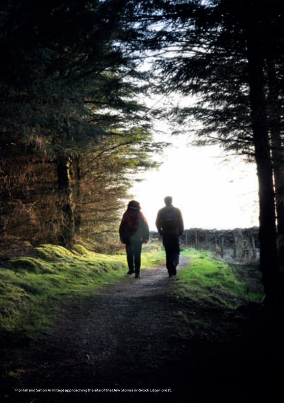
Pip Hall and Simon Armitage approaching the site of the Dew Stones in Rivock Edge Forest.

THE DEW STONES continuedRIVOCK EDGE, OFF THE SILSDEN TO EAST MORTON ROAD
About the Dew Stones“A disused gateway in the drystone wall was the inspiration for these outsized gateposts which block the gateway – but permit light to pass through. I chose a thick slab of Scoutmoor gritstone at Marshall’s Brighouse quarry. The stone was sawn down the middle, resulting in two halves
which, when opened out, mirrored each other. The holes at the edges were drilled so the stone could be split. This technique, involving hammering wedges into the holes, is known as ‘plug and feather’ and dates back to ancient Egyptian times.” Pip Hall
The WalkHaving parked, walk up the road to the T-junction.
Turn left and walk along the Silsden road for 200m. You will see a cluster of barns on your right with three wooden gates, leading to a wide gravelled track signed ‘footpath and bridleway’.
Go through the footpath gate and follow the track up towards the TV mast.
(For a short cut at the start: turn left at the top of Banks Lane for a few yards. Cross the road and go over the stone stile in the wall on your right. Go diagonally across the field and over another stone stile to join the gravelled track towards the TV mast.)
100m before the TV mast you’ll see a wide farm gate and smaller metal gate, on your right.
Go through the smaller gate and, ignoring the vehicle track leading to your right, go slightly left through another gate. Now go diagonally left across the field to a futher gate (this is a bridleway, so look for hoof prints).
Go through this further gate and straight across the next field.
This field rises slightly in the centre and as you get to the top of the rise, you will see a metal gateway into Rivock Forest beyond.
Go through this gateway and follow the clearly defined path straight on, through the coniferous forest.
After 10 minutes on the forest path, you will go downhill round a bend to the left.
As the path emerges at the edge of the trees you will see the two large Dew Stones in front of you.
Photo: Dew rising on Rivock Edge.
STANZA STONES POETRY TRAIL GUIDE
14
SH
OR
T F
AM
ILY
WA
LKS

DEW STONES WALK2.4KM/1.5 MILES IN TOTAL
TV mast
Short cut
SILSDEN RD
TO PUDDLE STONES3 MILES
SILSDEN
BA
NK
SLA
NE
HOLDEN LANE
TRIPLEGATEWAY
STILE
STILE
GATE
GATE
N
Dew enters the fieldunder cover of night …
Parking
Stanza Stone
Stile
Gate
Forest
Track
Road
Stanza Stones Trail
MAP KEY
STANZA STONES POETRY TRAIL GUIDE
15
SH
OR
T F
AM
ILY
WA
LKS

TIME TAKEN 15 minutes each way.
DISTANCE 1km/0.7 miles each way.
ACCESS A sandy and flagged path across moorland. Not suitable for wheelchair users or buggies. Determined pushers might make it with an all-terrain type buggy.
REFRESHMENTS AND TOILETS Pubs and cafés in Silsden and on the B6265. Toilets: in Silsden. For all details see Dew Stones (page 12)
GETTING THERE AND PARKING Follow the directions from Silsden or Bradford for the Dew Stones (see page 12).
Instead of turning down Banks Lane, continue on the Silsden Road towards East Morton and Menston for another mile, until you come to the cross roads of Ilkley Road and Street Lane. (Map ref SE087432.)
Turn left here up Ilkley Road, which is marked ‘Unsuitable for vehicles after 1¾ miles’. Follow this road through moorland to Whetstone Gate Wireless Station, where you will find an informal car park.
The WalkAs you stand in the car park looking towards the wireless masts, go through the main metal gate on your left.
Immediately turn right along what is currently a sandy path, although due to be flagged.
Walk up this path, passing the masts of the Wireless Station on your right.
Follow the path (now flagged) through the large scattered rocks on either side – some of these are known as the ‘Thimble Stones’.
The path curves to the left and then to the right. Once it straightens out look for the Puddle Stones.
They are about 200 metres beyond the Thimble Stones. Look for a large round rock outcrop to your right. The Puddle Stones are two large slabs lying on the ground about 3 metres off the path.
THE PUDDLE STONESWHETSTONE GATE WIRELESS STATION, ROMBALDS MOOR
An inspiring, relatively level walk, high on wild moorland.
About the Puddle Stones“These gritstone pavers were reclaimed from an industrial site near Bolton. Originally quarried on the Yorkshire moors in the nineteenth century, and transported for mill-factory flooring, they have made their return journey, over a hundred years later, to rest on Rombalds Moor.
The holes cut in the stones still have rust in them, showing where iron machinery was once set. In places where the iron fixings wouldn’t budge, they have been cut out, leaving rusty stumps. For a poem which begins ‘Rain-junk’, using these recycled stones seemed appropriate.” Pip Hall
STANZA STONES POETRY TRAIL GUIDE
16
SH
OR
T F
AM
ILY
WA
LKS

PUDDLE STONES WALK2KM/1.4 MILES IN TOTAL
Some May morningsAtlantic storm-horsesclatter this way …
Radio masts
Trig point
ThimbleStones
ILKLEY RD
GATE
N
TO IL
KLE
Y (N
o ca
rs)
Parking
Stanza Stone
GateRoadFootpathStanza Stones Trail
MAP KEY
STANZA STONES POETRY TRAIL GUIDE
17
SH
OR
T F
AM
ILY
WA
LKS

DISTANCE Route 1: 20 mins each way. 700 metres/0.5 miles each way.Route 2: 25 mins each way. 1.2 km/ 0.8 miles each way.Route 3: 15 mins each way. 300 metres /0.3 miles each way.
ACCESS See details for each route.Children will need supervision by the stream.
REFRESHMENTS AND TOILETS Refreshments at the Cow and Calf car park kiosk, Cow and Calf Pub, Rombalds Hotel on Wells Road, White Wells House – the white house on the moor (when the flag’s flying!), Craiglands Hotel and numerous tea shops in Ilkley including the famous Bettys Café Tea Rooms. Toilets: Ilkley’s main car park, the Cow and Calf car park kiosk and White Wells House.
ROUTE 1: FROM THE COW AND CALF ROCKS CAR PARKA relatively level, narrow footpath used by many local families, although not suitable for buggies or wheelchair users, with steep downhill and uphill sections.
GETTING THERE AND PARKING From the centre of Ilkley at the juction of Brook Street and The Grove (LS29 9HS) follow the signs to the Cow and Calf Rocks up Cowpasture Road.
Park in the Cow and Calf Rocks car park on the right at the top of Hangingstone Road.
The Walk (Route 1 – Cow and Calf)Go into the oblong ‘extension’ to the main car park. From the far end, take the right hand of two well-marked paths leading from it, so that you keep on the road side of the enormous ‘Calf’ Rock.
Stay on this path, without turning down to the road or up to the rocks, for about 10 minutes.
As you come towards a belt of trees in front of you, the path meets ROUTE 3 coming up from the right.
On reaching this T-junction, turn left and continue uphill for a few minutes to where steep shallow steps on your right lead down to a wooden bridge over the Beck.
Take these steps down but do NOT cross the bridge!
m ALL ROUTES Instead, take the steep footpath uphill to your left, which follows the line of the Beck, for about 30 metres.
Look out for a very large rock with a large gorse bush beside it on your right hand side.
Stop here and squeeze between the rock and the gorse bush and you will see the Beck Stone in the stream to your left.
To visit the Stanza Stones Poetry Seat continue up the footpath, with the stream on your right, for a further 400 metres until you reach a level area where you can cross the stream. (See photo page 20.)
Continue with the stream on your left for another 600 metres, until you reach the Poetry Seat. Do post a poem here!
THE BECK STONEBACKSTONE BECK ON ILKLEY MOOR
Three different routes which take in the best of the lower slopes of Ilkley Moor, with bracken, heather, a tarn (a small mountain lake) and rushing streams.
STANZA STONES POETRY TRAIL GUIDE
18
SH
OR
T F
AM
ILY
WA
LKS
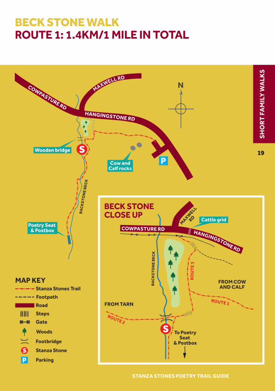
BECK STONE WALKROUTE 1: 1.4KM/1 MILE IN TOTAL
COWPASTURE RD
Cattle grid
FROM COWAND CALF
FROM TARN
To PoetrySeat
& Postbox
HANGINGSTONE RD
BA
CK
ST
ON
E B
EC
K
MAXW
ELLRD
ROUTE 1
ROUTE 2
RO
UT
E 3
Poetry Seat & Postbox
Cow andCalf rocks
Wooden bridge
COWPASTURE RDHANGINGSTONE RD
MAXWELL RDB
AC
KS
TO
NE
BE
CK
N
BECK STONE CLOSE UP
Stanza Stone
Parking
Footbridge
Gate
Woods
Steps
Road
Footpath
Stanza Stones TrailMAP KEY
STANZA STONES POETRY TRAIL GUIDE
19
SH
OR
T F
AM
ILY
WA
LKS

THE BECK STONE continuedBACKSTONE BECK ON ILKLEY MOOR
ROUTE 2: FROM THE TARNA wide tarred uphill path to the Tarn (a small lake). Shallow steps to a narrow footpath with a short muddy descent and then uphill to the Beck Stone.
GETTING THERE AND PARKING From the centre of Ilkley drive up Wells Road. As the road curves round to the right, cross the cattle grid and park in the car park on the right hand side beside the Darwin Gardens.
Alternatively park in the main car park in the centre of town or arrive at Ilkley Station and walk up Wells Road.
The Walk (Route 2 – Via Tarn)Cross the road from the Darwin Gardens car park. Turn to the left and walk back a few metres to the junction of Wells Road and Crossbeck Road.
At the Crossbeck Road sign, take the diagonal drive on your right which seems to go into a small tarmac parking area in front of houses.
Ignore the gate and footpath to your right (which goes to the paddling pool) and go straight ahead to a large metal gate.
Go through this gate and up the tarred road. Follow it all the way up to where it levels out round a Tarn.
Follow the path round the right side of the Tarn.
At the very far end, just before the bench, go up the short flight of steps on your right, to a footpath.
Follow this footpath for about five minutes until it goes up over a rise and then steeply downhill to the Beck below.
Cross the wooden bridge over the Beck and then follow from ALL ROUTES m (see page 18).
Photo: Ilkley Moor where the
path from the Beck Stone
to thePoetry Seat crosses
Beckstone Beck.
STANZA STONES POETRY TRAIL GUIDE
20
SH
OR
T F
AM
ILY
WA
LKS

BECK STONE WALKROUTE 2: 2.4 KM/1.6 MILES IN TOTAL
Wooden bridge
Bus and rail station
Poetry Seat & Postbox
ILKLEYCENTRE
CR OSSBE C K RD
WELLS RD
THE GROVE
COWPASTURE RDHANGINGSTONE RDTARN
MAXWELL RD
STEPS
BA
CK
ST
ON
E B
EC
K
BR
OO
K S
T N
The unbroken threadof the beckwith its nose for the sea …
Stanza Stone
Parking
Footbridge
Road
Track
Stanza Stones TrailMAP KEY
STANZA STONES POETRY TRAIL GUIDE
21
SH
OR
T F
AM
ILY
WA
LKS

ROUTE 3: FROM HANGINGSTONE ROADA short, sharp, uphill route with a steep downhill section.
GETTING THERE AND PARKING From the centre of Ilkley at the juction of Brook Street and The Grove (LS29 9HS) follow the signs to the Cow and Calf Rocks up Cowpasture Road. Look out for Craiglands Hotel on the right. Park in the small tree lined car park, also on the right, just after the hotel.
Alternatively park in Maxwell Road, a broad one way street, further up on your left.
The WalkIf you have parked in the tree lined car park, walk up the road until you reach the Hangingstone Road sign, just before the cattle grid. If you have parked in Maxwell Road simply cross the main road to reach the same point.
Make sure you go through the small metal gate here on your right, just before the grid (and not one of the two metal gates lower down).
Follow the footpath to your left up six shallow steps.
Before the seventh step, turn sharply right up what seems to be a very narrow path but immediately broadens out.
Follow this path uphill until you see the steep shallow steps on your right leading down to a wooden bridge over the beck.
Take these steps down but DO NOT cross the bridge! Then follow ALL ROUTES m (see page 18).
THE BECK STONE continuedBACKSTONE BECK ON ILKLEY MOOR
About the Beck Stones“The last stone to be carved, this is the only poem I drew freehand as the very rough and curved surface of the boulder
made tracing impossible. It’s also the only poem I carved while standing in a beck!” Pip Hall
Photo: Rock outcrop
on Ilkley Moor.
STANZA STONES POETRY TRAIL GUIDE
22
SH
OR
T F
AM
ILY
WA
LKS

BECK STONE WALKROUTE 3: 600 METRES/0.6 MILES IN TOTAL
COWPASTURE RD
Cattle grid
Poetry Seat & Postbox
HANGINGSTONE RD
BA
CK
ST
ON
E B
EC
K
MAXW
ELLRD
RO
UT
E 3
BA
CK
ST
ON
E B
EC
K
N
Stanza Stone
Parking
Footbridge
Gate
Woods
Steps
Road
Footpath
Stanza Stones TrailMAP KEY
STANZA STONES POETRY TRAIL GUIDE
23
SH
OR
T F
AM
ILY
WA
LKS
Three Full Day WalksThe three legs are laid out here in sequence from Marsden to Ilkley making three very enjoyable full day walks, although of course they can be tackled in whichever order suits you – and at intervals to suit your diary.
Check the distance of the leg you intend to tackle and plan your time well before you set off: the leg from Marsden to Hebden Bridge is the longest and most arduous, so think carefully before planning to walk it in winter because there may not be enough daylight. It would also be also possible to break the first leg by staying in the Littleborough area.
The Full TrailIf you’ve decided to do the whole Trail in one go, simply follow through all three legs.
How to PrepareThe amount of preparation required will obviously vary depending how far you are going and when.
Outdoor clothing and stout footwear are essential for everyone, with survival gear for anyone tackling the moorland sections included in every leg.
A whistle, mobile phone, map and compass (plus knowledge of how to use them) and spare food and drink should be a minimum, with items such as survival bag, first-aid kit and torch desirable.
AccommodationPeople tackling the full trail may decide to carry a tent and sleeping bag.
You’ll find camp sites at Pule Hill, Sowerby Bridge, Hebden Bridge, Oxenhope, Cullingworth, Harden near Bingley and Silsden.
For permission to wild-camp, negotiate directly with the relevant landowner.
An alternative is to book bed and breakfast, a pub or hotel in advance.
There are plenty of options available in Marsden, Littleborough, Hebden Bridge, Oxenhope, Haworth, Bingley and Ilkley.
For information about all these go to www.yorkshire.com or consult the Visitor Centres in Marsden, Hebden Bridge, Haworth and Ilkley for advice.
TACKLING THE LONGER WALKS
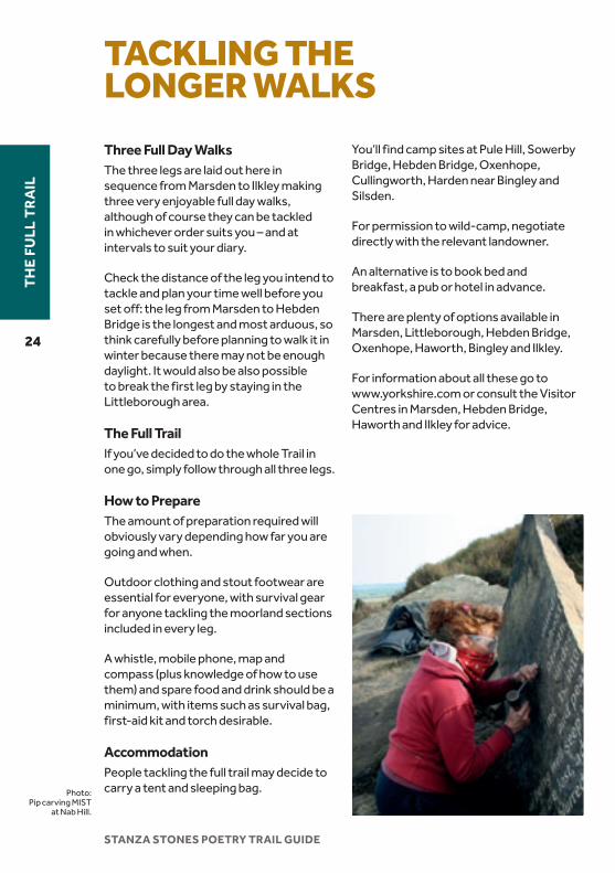
Photo: Pip carving MIST
at Nab Hill.
STANZA STONES POETRY TRAIL GUIDE
24
TH
E FU
LL T
RA
IL

Standedge Visitor Centre at Tunnel End, Marsden – Leg 1.

START MARSDEN STATION Map ref SE 047118
Join the canal towpath on the south side of the railway and then set off westwards towards Standedge Visitor Centre: www.standedge.co.uk.
Take a few minutes to read the signs with fascinating history of the remarkable tunnel building. The Visitor Centre contains much more information, but beware of lingering too long, because this leg is long and arduous.
Cross the bridge and go straight across the car park. Then take the path up the grass slope opposite (part of the reservoir dam whose spillway you see flowing over the railway to your left) and head towards the left hand corner.
Join the road over the dam and continue left to the main A62 road.
Turn right on the main road footpath for a few metres and then take care crossing the road onto the track opposite.
Just before the buildings at the end of this track, find a gap in the fence on your right and follow the worn path towards the obvious summit above you with a memorial cross visible.
On reaching the summit, take a minute to look out over Marsden (Simon’s Armitage’s birthplace) and Tom Lonsdale’s farm on the opposite side of the valley above the trees.
Take the path, past the ventilator shaft for the tunnel, in a roughly westerly
direction for about half a mile until it runs along the top of the rocky escarpment of Standedge.
Just before these rocks, take the obvious path to the right, where it affords an easy route down the escarpment, and fork left to walk along the foot of the rock face until you enter the Pule Hill Quarry at the winch housing and join the short walk to the Snow Stone and Poetry Seat.
THE SNOW STONE Go to page 6 for directions.
After visiting SNOW descend the incline towards the main road, taking care to bypass the steep drop at the bottom where stone used to be loaded for transport to its destination.
Do this by cutting across to the right and joining a track by one of the ventilator shafts for the tunnels that run beneath you – three rail tunnels and the longest, deepest and highest canal tunnel in the country – to a gate.
Go through the gate. Turn to the left and walk up the verge on the side of the road to the track on the right virtually opposite the Carriage House pub.
Take this track. Pass yet another tunnel-related structure on your left and continue on the well-worn and partly flagged path until it meets the Pennine Way. Here turn right, signposted ‘North’.
From this point almost to Hebden Bridge it should be possible to navigate comfortably by following the Pennine Way signs, so this guide mentions only key moments on the rest of the leg.
LEG 1MARSDEN TO HEBDEN BRIDGE29.6KM/18.4 MILES
STANZA STONES POETRY TRAIL GUIDE
26
TH
E FU
LL T
RA
IL

MAPMARSDEN TO HEBDEN BRIDGE29.6KM/18.4 MILES
RAIN
SNOW& Seat
Trailstart
Penn
ine
Way
PennineWayHu
dders
field
Canal
Blackstone Edge
HEBDEN BRIDGE
TODMORDEN
MARSDEN
DENSHAW
MILNROW
LITTLEBOROUGH
RIPPONDEN
SOWERBYBRIDGE
Rochdale Canal
B6138
A646
A646
A6033
A60
33
A672
A62
A58
A640
A6033
M62
N
Stanza Stone
Stanza Stones Trail
KEY
Train station
STANZA STONES POETRY TRAIL GUIDE
27
TH
E FU
LL T
RA
IL
LEG 1MARSDEN TO HEBDEN BRIDGE continued29.6KM/18.4 MILES
Go straight across the A640 at map ref SE 002123 and over the summit of White Hill. When you eventually meet the A672 at SD983141, cross over and pick up the continuation of the Pennine Way.
Then, pass the radio mast on your left to cross the M62 via the narrow and scarily high bridge: don’t look down if you are afraid of heights but just be glad you’re not in one of those cars!
Walk along the magnificent Blackstone Edge, with its weird shaped rocks, and drop down to the left at the historic Aiggin Stone to Broad Head Drain.
Turn right along the drain until the path drops down to the left to the A58 and join the short walk to the Rain Stone by the White House pub.
THE RAIN STONE Go to page 8 for directions.
After visiting RAIN, continue to the far end of the quarry and over rough ground to rejoin the track and more Pennine Way signs, bearing right slightly after the second reservoir.
Take care not to stray onto the Todmorden Centenary Way where it leaves the Pennine Way here.
Stoodley Pike soon appears in the distance as a useful landmark. From Stoodley Pike monument, the path runs eastwards for a while before dropping down to the left and across fields to Lower Rough Head, where you join the farm track down a wooded valley.
A few hundred metres after entering the woods, look out for a path to the right that takes you over a bridge to the other side of the valley.
Follow this path until it joins the road down into Hebden Bridge near a hamlet called Horsehold.
Continue down this road to the bridge over the canal at the bottom of the hill.
From here you can either join the canal to the right to take you to the station, or continue to the main street and explore the town before heading to the station at the eastern end, just off the A646.
Full TrailThere’s much to see in Hebden Bridge to reward exploration, including poet Sylvia Plath’s grave in Heptonstall, a 30 minute walk away. But if you’re not staying in the town overnight, the shortest route onto the next leg is to follow Market Street (A646) until you cross the bridge over the River Calder.
Here turn left onto Bridge Gate, follow it right to the end and turn left onto Keighley Road (A6033).
Photo: Approaching
Stoodley Pike between the
Rain Stone and Hebden Bridge
STANZA STONES POETRY TRAIL GUIDE
28
TH
E FU
LL T
RA
IL

Looking up Luddenden Dean. Leg 2 crosses here in the middle distance.

LEG 2HEBDEN BRIDGE TO BINGLEY23.3 KM/14.5 MILES
START HEBDEN BRIDGE STATION Map ref SD 995268
Hebden Bridge is well worth exploring before you set out.
From Hebden Bridge Railway Station go down the exit road to the A646 Halifax/Burnley Road. Turn left for a short distance and then bear right onto Commercial Street (A6033 Haworth/Keighley Road).
Follow the pavement up Keighley Road until you reach the traffic lights and woodland on the right just before Nutclough Tavern. Turn right here, following a Link Path sign on a telegraph pole, up the footpath, through the metal gate into Nutclough Wood.
Follow the Calderdale Way signs as far as the bridge, then turn off the track, into the field on the left bank of the river above the bridge. Follow the fingerpost, and then the yellow posts, up through heather to a wall at the corner of a field. Go diagonally right across this field onto a narrow lane leading to ‘Club Houses’ cottages. Turn left at the end of this road and go up Walker Lane to Chiserley.
When you reach the junction with the main road at the top, go straight across up a narrow track next to a sign ‘Billy Lane’, which soon narrows to a path.
At the top of this path, turn right onto the farm track and continue uphill to Hebden Bridge Equestrian Centre.
Go over the stile ahead and follow a faint path diagonally right, towards the isolated house with conifers and a windmill, ignoring signposts for the Calderdale Way.
Keep left behind the house and follow a bridleway track across the moor in an easterly direction, ignoring any footpaths crossing it. Go over the brow of the moor, dropping until you enter a walled track down to a bridleway in the valley bottom (Catherine House Lane).
Turn left at the bottom and continue on the track until you pass under the arch of the castellated Lowe Farm. Turn right to cross Lowe Bridge over Luddenden Brook.
Follow the road round the corner and, starting to go uphill, take a footpath signed over a stile to your left. Climb steeply up the hillside, keeping to the path with marker posts, to another property with castle-like battlements.
Cross over the minor road and go over another stile, following the footpath across Warley Moor towards Ovendon Moor wind farm. At Slade join the farm track. Then take the footpath, bearing slightly left across a rough field, to reach Cold Edge Road. Continue northwards along the road for approx 1.6 km, passing Warley Moor Reservoir (Halifax Sailing Club) on your left, until you join the short walk to the Mist Stone at the first footpath and stile on the right.
THE MIST STONE Go to page 10 for directions.
After visiting MIST, return to the main path and continue along the edge in an easterly direction until it descends diagonally left to a stile at Hambleton Lane. Turn left down to the bottom of this lane, noting the deep ruts in the stone worn away by horse-drawn cartwheels.
STANZA STONES POETRY TRAIL GUIDE
30
TH
E FU
LL T
RA
IL

MAPHEBDEN BRIDGE TO BINGLEY23.3 KM/14.5 MILES
MIST
KEIGHLEYBINGLEY
HARDEN
HAWORTH
CULLINGWORTH
HALIFAXMYTHOLMROYDHEBDEN
BRIDGE
SOWERBYBRIDGE
QUEENSBURY
OXENHOPEB6141
B6144
B6429
A650
A629
A60
33
Wind farm
Midgley Moor
Warley Moor
Cold Edge Road
A646 Rochdale Canal
Leeds & Liverpool Canal
River Aire
N
Stanza Stone
Stanza Stones Trail
KEY
Train station
STANZA STONES POETRY TRAIL GUIDE
31
TH
E FU
LL T
RA
IL

LEG 2HEBDEN BRIDGE TO BINGLEY continued23.3 KM/14.53 MILES
Follow the track round to the right at the bottom, passing Thornton Moor Reservoir dam on your right, until the road (now tarmaced) turns sharp right. Here take the gate on your left, following signs to Sawood, along the Calder Aire Link Bridleway.
Walk right down the road and across the cross roads with the Dog and Gun pub on your right. (A good place to stop if you are ready for food and drink.) Follow Trough Lane to a T-junction with the A629. Here turn left, and then immediately right onto the B6429 towards Cullingworth.
Almost immediately, take the Calder Aire Link path to the right, along the top of the wooded disused quarry. Follow these signs across the B6144, to the end of Hallas Lane where you descend into a wooded valley.
At the footbridge – if you are comfortable with scrambling down some awkward rock steps – go along the river bank, following the Goitstock and Senior Way sign. You will be rewarded by a spectacular waterfall and a delightful woodland walk.
If you prefer an easier walk, instead of turning left along the river go straight ahead to the cottages on the left and along the front of these to a stile into a field footpath. This path runs along the top of the wood and eventually enters it to rejoin the ‘riverside’ route.
If you have taken the ‘riverside’ route, turn right up the hill when you reach the modern housing. Bear left around the top of the first house’s garden, and up through the woodland to rejoin the alternative path just inside the woodland edge. Follow this path until you come to a road beside a row of cottages on your left.
Turn left for a short distance then cross the road to the field footpath on your right. Go across the field to stepping stones over the river. Cross the stepping stones and join the track winding up the hill to the right.
Before reaching the top, branch off to the right following a ‘pedestrians only’ sign. Follow the woodland path until you reach the top edge of the wood shortly before a massive slab of stone with a step-through stile.
Immediately after this slab take the field footpath to your left over several fields until you meet a quiet lane. Here you go diagonally left to continue across more fields, turning left sharply between walls and then diagonally right, to the corner of the wood ahead.
Continue straight ahead into the wood and then diagonally down the slope to a stile at the bottom. Climb the stile and aim for the bottom edge of the wood ahead, where you enter the Shipley Golf Course. Follow the white painted boulders to a footbridge over Harden Beck.
Turn right along this track, crossing another lovely old bridge, before turning left along the side of the allotments. This takes you over the wide River Aire and into Bingley’s Myrtle Park. Pass the play area on your left and bandstand on your right to arrive at the main square, where you can cross the road by the Pelican and go down Foundry Hill to Bingley Station.
Full TrailFor the full trail follow the directions for Leg 3 from the station forecourt.
STANZA STONES POETRY TRAIL GUIDE
32
TH
E FU
LL T
RA
IL

Rombalds Moor – one of the many wet areas that inspired Puddle.

LEG 3BINGLEY TO ILKLEY23.3 KM/14.1 MILES
START BINGLEY STATION Map ref SE 107391
Turn right on exiting Bingley Railway Station and right again onto Park Road, over the Aire Valley dual carriageway. Then turn left immediately down a footpath that joins the canal below, which delivers you to the remarkable Bingley Three Rise Locks.
If this engineering fascinates you there is greater reward as you continue northwards along the canal towpath, shortly reaching the Grade 1 Listed Bingley Five Rise Locks (and a café).
It’s difficult to get lost on the next section, as you follow the towpath for three miles to Leche’s Bridge. Here you cross to the north bank and continue along the track beside the canal.
After about 200 metres, opposite a house clearly numbered ‘4’, turn right into woodland. Climb directly up the hillside, crossing a track halfway up. Then go across a field to another lane, where you turn right to meet Banks Lane.
Turn left up Banks Lane and proceed to its T-junction with Silsden Road at the top and join the short walk to the Dew Stones.
THE DEW STONES Go to page 14 for directions.
After visiting DEW continue along the bridleway. Where you meet the forest track the bridleway turns sharp left (signposted). Follow this for a further 800 metres until you come out of the forest near Black Potts.
Follow the track, passing Black Potts Farm on your right and the precariously balanced Doubler Stones perched on the skyline. Just after the next large farm on your left, turn right beside the cottage onto a path that gradually becomes more distinct, passing the Doubler Stones outcrop on your right.
Continue, over a wall, until you reach the summit at Black Hill. Just before another rocky outcrop facing north, you will see a crossroad of paths
Turn right at this crossroads, following the Millennium Way along the edge. Pass the Noon Stone and a number of gates until you go through a wall on the skyline with a large jumble of rocks on your left.
Proceed the short distance to the next wall but do not go through it. Instead turn right and walk alongside the wall to the corner. Then go very slightly right to pick up a path climbing the hill ahead.
As you reach the crest you will see the forest again ahead of you. Walk directly towards it, until another path forks off to the left about 100 metres before the forest edge. Follow this path along the forest edge to West Buck Stones.
Go a short distance eastwards to the wonderfully sculpted (by nature) East Buck Stones, and then follow the wall and fence on your right to Whetstone Gate Wireless Station. Here join the short walk to the Puddle Stones.
THE PUDDLE STONES Go to page 16 for directions.
STANZA STONES POETRY TRAIL GUIDE
34
TH
E FU
LL T
RA
IL

MAPBINGLEY TO ILKLEY23.3 KM/14.1 MILES
DEWPUDDLE
BECK
SEAT
TrailendsILKLEY
BINGLEY
RIDDLESDEN
TO SILSDEN
KEIGHLEY
Ilkley Moor
RombaldsMoor
Twelve ApostlesThimble
Stones
Midgley Moor
Silsden Road Ikle
y Ro
ad
Bank
sLa
ne
Leeds & Liverpool
Canal
River Aire
RombaldsMoor
A650
B6265
A65
N
Stanza Stone
Stanza Stones Trail
KEY
Train station
STANZA STONES POETRY TRAIL GUIDE
35
TH
E FU
LL T
RA
IL

LEG 3BINGLEY TO ILKLEY continued23.3 KM/14.1 MILES
After visiting the Puddle Stones continue easterly, passing the Trig Stone until you reach the Twelve Apostles stone circle.
Here, turn around and go back the way you have just come for about 120 metres, then fork right, downhill along the Dales Way Link.
After approximately half a mile, the path crosses a stream (Backstone Beck) flowing to your right. Immediately after you cross the stream, take the right fork and follow the path on the left bank of the stream.
A very short way down this path you reach the Ilkley Stanza Stones Poetry Seat. This is built around the remains of a former shooting lodge.
Please do post a poem in the Poetry Postbox and take one in return if you’d like to.
Carry on downhill, with the Beck down below to your right, until the path arrives at an open area, with the Beck levelling out before cascading over rocks to your left.
Cross the Beck and turn immediately left to descend further, now with the water on your left.
After about 200 metres, take the right fork over the summit ahead to arrive at a large quarry.
Drop down into the quarry and make your way over to the large rock which is on the left as you look along the quarry: this rock has some of the best ancient ‘cup and ring’ carving on its top.
From this rock, head back just to the right of the route you came on.
Drop down diagonally through the trees in the direction of the Backstone Beck valley you left in order to visit the quarry.
About 50 metres before you reach a footbridge over the Beck, begin to climb up the left bank of the Beck towards a very large stone beside some gorse bushes.
Squeeze between the stone and the gorse bush and you will see the Beck Stone to your left in the stream.
Drop back down to the bridge, cross it and then follow the footpath westerly to the Tarn.
Walk round either side to pick up the path beyond to Wells Road.
Here turn right, following this down into Ilkley town centre passing Rombalds Hotel (which serves teas, as does White Wells House on the Moor, if the flag is flying) and arriving at the main road at the bottom where you turn right for Ilkley Railway Station.
Congratulations on completing the Trail!
Ilkley has a wealth of cafés, pubs and tea rooms to refresh you and several excellent hotels.
If you time your walk for the first two weeks of October, you will arrive during the popular Ilkley Literature Festival. Please come to any of the Festival venues and make yourself known so we can celebrate with you!
STANZA STONES POETRY TRAIL GUIDE
36
TH
E FU
LL T
RA
IL

YOUNG PEOPLE AND THE STANZA STONES PROJECT
As part of the Stanza Stones project Ilkley Literature Festival worked with six groups of young writers from across Yorkshire: Calderdale Young Writers, Ilkley Young Writers, Leeds Young Authors, Sheffield Young Writers, Tadeeb International New Writers based in Bradford and the Writing Squad.
Over 50 young people aged 12-28 took part in master classes with Simon, visited the moors with him to see the places which had inspired his work and then created their own poems. It was a unique initiative, supported by the Esmée Fairbairn Foundation and while some of the young people came from rural areas and knew the moors well, others lived in large cities and had never been out on the Pennines before.
You can read the young people’s work, together with Simon Armitage’s Stanza Stones poems, in a special Stanza Stones
anthology which you can download from the Ilkley Literature Festival website- www.ilkleyliteraturefestival.org.uk
And some of their words can also be found on a new sculpture by Peter Maris at Scammonden Water near Ripponden.
To celebrate the opening of the Trail in May 2012 the young writers passed their poems over to young dancers from: Northern School of Contemporary Dance, RJC Dance, North Yorkshire (Youth) Dance, students from Longley School working with Manasamitra and young film makers from Leeds College of Art and Media Fish (part of Leeds Young Film).
The result was an inspiring array of dance pieces and short films, interpreting the poems in new ways. The project culminated in three performances by Simon Armitage, the young writers, dancers and film makers in Marsden, at Nab Hill and on Ilkley Moor.
Photo: Students from Northern School of Contemporary Dance rehearse their interpretation of poems by the Writing Squad at Nab Hill.
STANZA STONES POETRY TRAIL GUIDE
37
YO
UN
G P
EOPL
E A
ND
S
TAN
ZA
ST
ON
ES

ACKNOWLEDGEMENTSimove has been primarily funded by Legacy Trust UK, creating a lasting impact from the London 2012 Olympic and Paralympic Games by funding ideas and local talent to inspire creativity across the UK. imove is also funded by Arts Council England. www.imoveand.com
We are extremely grateful for the help of the following, whose contributions, support and advice were invaluable:
David Brown, UPM Tilhill forest managerAlastair Harvey, Yorkshire WaterRob Dyer, British Mountaineering CouncilEmma Fawcett, Natural EnglandDanny Jackson, Bradford CouncilYvonne Luke, English HeritageNick Lunt, Yorkshire WaterMarshalls who kindly donated the Dew Stones
Judith Patrick, National TrustRichard Perham, Bradford CouncilRick Roberts, Dinsdale Moorland ServicesJonathan Rogers, CA Rogers Forestry ServicesJane Stuart, Natural EnglandPaul Tyson, Natural EnglandDinsdale Moorland ServicesUPM Tilhill
Boothman family of SilsdenDarrell CleggDavid CollinsAndrew CrossleyMike DuddingJack FearnDavid Hartley
Sue HinchcliffeTony MetcalfeVernon RobinsonOwen Wells and the Friends of Ilkley MoorJames WilkinsonAndrew Wood
ProductionDesign dg3 Print AB WellanAll photos © Tom Lonsdale except © Pip Hall: front cover thumbnail, pages 7, 9, 11 ,15. © David Collins: 17, 22, 23, 37.
ThanksThis project would not have been possible without the support of the landowners and statutory bodies who have so generously given us permission for the Stanza Stones sites:
Bradford Metropolitan District CouncilEnglish Heritage
National Trust
Natural EnglandOwner of Rivock Edge ForestUnited UtilitiesYorkshire Water
Jeremy Dearden, Lord of the Manor of Rochdale
Pennine Prospects, a rural regeneration company, supported the project through the South Pennines LEADER programme (Rural Development Programme for England), which is jointly funded by Defra and the European Union. www.pennineprospects.co.uk
Back cover photo: Step
through stile – Leg 2.
STANZA STONES POETRY TRAIL GUIDE
38
AC
KN
OW
LED
GE
ME
NT
S

Bingley Five Rise Locks on the Leeds & Liverpool Canal – Leg 3.

Ilkley Literature FestivalThe Manor House, 2 Castle Hill, Ilkley LS29 9DT01943 601210 [email protected]
www.ilkleyliteraturefestival.org.uk
www.facebook.com/ilkleyliteraturefestival
@ilkleylitfest #stanzastones
Registered In England and Wales Company No: 1061343. Ilkley Literature Festival is a registered charity. Charity No: 501801