state of california - caltrans · sco/neg-dec.doc/010650012 state of california sch no....
TRANSCRIPT
SCO/NEG-DEC.DOC/010650012
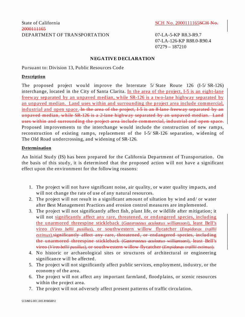
State of California SCH No. 2000111165SCH No.2000111165DEPARTMENT OF TRANSPORTATION 07-LA-5-KP R8.3-R9.7
07-LA-126-KP R88.0-R90.407279 – 187210
NEGATIVE DECLARATION
Pursuant to: Division 13, Public Resources Code
Description
The proposed project would improve the Interstate 5/State Route 126 (I-5/SR-126)interchange, located in the City of Santa Clarita. In the area of the project, I-5 is an eight-lanefreeway separated by an unpaved median, while SR-126 is a two-lane highway separated byan unpaved median. Land uses within and surrounding the project area include commercial,industrial and open space. In the area of the project, I-5 is an 8-lane freeway separated by anunpaved median, while SR-126 is a 2-lane highway separated by an unpaved median. Landuses within and surrounding the project area include commercial, industrial and open space.Proposed improvements to the interchange would include the construction of new ramps,reconstruction of existing ramps, replacement of the I-5/SR-126 separation, widening ofThe Old Road undercrossing, and widening of SR-126.
Determination
An Initial Study (IS) has been prepared for the California Department of Transportation. Onthe basis of this study, it is determined that the proposed action will not have a significanteffect upon the environment for the following reasons:
1. The project will not have significant noise, air quality, or water quality impacts, andwill not change the rate of use of any natural resources.
2. The project will not result in a significant amount of siltation by wind and/or waterafter Best Management Practices and erosion control measures are implemented.
3. The project will not significantly affect fish, plant life, or wildlife after mitigation; itwill not significantly affect any rare, threatened, or endangered species, includingthe unarmored threespine stickleback (Gasterosteus aculeatus williamsoni), least Bell’svireo (Vireo bellii pusillus), or southwestern willow flycatcher (Empidonax trailliiextimus).significantly affect any rare, threatened, or endangered species, includingthe unarmored threespine stickleback (Gasterosteus aculeatus williamsoni), least Bell’svireo (Vireo bellii pusillus), or southwestern willow flycatcher (Empidonax traillii extimus).
4. No historic or archaeological sites or structures of architectural or engineeringsignificance will be affected.
5. The project will not significantly affect public services, employment, industry, or theeconomy of the area.
6. The project will not affect any important farmland, floodplains, or scenic resourceswithin the project area.
7. The project will not adversely affect present patterns of traffic circulation.

______________________________________ _________________________Mr. Ronald Kosinski DateChief, Environmental Planning BranchCalifornia Department of TransportationDistrict 7
SCO/TITLE PG-TOC-ACRO.DOC/0106500013
SCH: 200011116507-LA-126 KP R8.3-R9.707-LA-5 KP R88.0-R90.4
EA: 187210May 2001
I-5/SR-126 Interchange Project
INITIAL STUDY/ENVIRONMENTAL ASSESSMENT
STATE OF CALIFORNIADepartment of Transportation
and
U.S. DEPARTMENT OF TRANSPORTATIONFederal Highway Administration
Pursuant to:42 U.S.C. 4332(2)(c)
Ron Kosinski DateCaltrans District 7Acting Division Chief
Michael G. Ritchie DateDivision AdministratorFederal Highway Administration
The following persons may be contacted for additional information concerning this document:
Robert CadyTransportation EngineerFederal Highway Administration980 Ninth Street, Suite 400Sacramento, CA 95814(916) 498-5037
Ron KosinskiActing Division ChiefCaltrans District 7120 South Spring StreetLos Angeles, CA 90012(213) 897-0703


Contents
SCO/TITLE PG-TOC-ACRO.DOC/0106500013 I
Section Page1 Purpose and Need .............................................................................................................. 1-1
1.1 Purpose of the Proposed Project ..........................................................................1-1
1.2 Need for the Project ...............................................................................................1-1
1.2.1 Operational Deficiencies ..........................................................................1-1
1.2.2 Capacity Constraints.................................................................................1-4
1.2.3 Accident Analysis .....................................................................................1-9
1.3 Project Status.........................................................................................................1-11
1.3.1 History of the Planning Process............................................................1-11
1.3.2 Other Relevant Documents....................................................................1-11
1.4 Required Coordination and Applicable Regulatory Requirements .............1-12
2 Description of Proposed Project......................................................................................2-1
2.1 Project Description.................................................................................................2-1
2.2 Relationship to State, Regional, and Local Transportation Planning.............2-1
2.3 Other Local Projects and Proposals .....................................................................2-1
2.4 Alternatives.............................................................................................................2-6
2.4.1 No-Build Alternative ................................................................................2-6
2.4.2 Alternative A – I-5/SR-126 Diamond Interchange Concept...............2-8
2.4.3 Alternative C – I-5/SR-126 Partial Cloverleaf AInterchange Concept...............................................................................2-10
3 Affected Environment.......................................................................................................3-1
3.1 Topography and Geology .....................................................................................3-1
3.2 Land Use and Planning.........................................................................................3-1
3.2.1 Existing Land Uses....................................................................................3-1
3.2.2 Proposed Developments ..........................................................................3-2
3.2.3 Local and Regional Land Use Plans .......................................................3-2
3.3 Farmland .................................................................................................................3-3
3.4 Social and Economic Conditions .........................................................................3-3
3.4.1 Population ..................................................................................................3-3
3.4.2 Housing ......................................................................................................3-3
3.4.3 Employment...............................................................................................3-6
3.5 Air Quality ..............................................................................................................3-6
3.6 Water Resources .....................................................................................................3-7
3.6.1 Surface Water.............................................................................................3-7
3.6.2 Groundwater..............................................................................................3-8
CONTENTS
SCO/TITLE PG-TOC-ACRO.DOC/0106500013 II
Section Page3.7 Wetlands..................................................................................................................3-8
3.8 Vegetation and Wildlife Resources......................................................................3-8
3.8.1 Vegetation ..................................................................................................3-9
3.8.2 Wildlife Habitat .......................................................................................3-10
3.8.3 Special-Status Plant and Wildlife Species............................................3-10
3.9 Floodplain .............................................................................................................3-11
3.10 Historic and Cultural Resources ........................................................................3-12
3.11 Hazardous Waste .................................................................................................3-15
3.12 Visual .....................................................................................................................3-15
3.13 Noise ......................................................................................................................3-16
3.14 Transportation and Traffic Circulation.............................................................3-16
4 Environmental Evaluation................................................................................................4-1
5 Discussion of Environmental Evaluation......................................................................5-1
5.1 Siltation (Question 5) .............................................................................................5-1
5.1.1 Project Impacts ..........................................................................................5-1
5.1.2 Mitigation ...................................................................................................5-1
5.2 Hazardous Waste (Questions 9 and 48)..............................................................5-2
5.2.1 Project Impacts ..........................................................................................5-2
5.2.2 Mitigation ...................................................................................................5-3
5.3 Water Resources (Questions 10, 12, and 15).......................................................5-3
5.3.1 Project Impacts ..........................................................................................5-3
5.3.2 Mitigation ...................................................................................................5-4
5.4 Floodplain (Question 11).......................................................................................5-5
5.4.1 Project Impacts ..........................................................................................5-5
5.4.2 Mitigation ...................................................................................................5-5
5.5 Air Quality (Questions 17 and 19) .......................................................................5-5
5.5.1 Project Impacts ..........................................................................................5-5
5.5.2 Mitigation ...................................................................................................5-7
5.6 Noise (Questions 20 and 21) .................................................................................5-8
5.6.1 Project Impacts ..........................................................................................5-8
5.6.2 Mitigation ...................................................................................................5-8
5.7 Biological Resources (Questions 23 to 25 and 27 to 31) ....................................5-9
5.7.1 Project Impacts ..........................................................................................5-9
5.7.2 Mitigation .................................................................................................5-11
5.8 Agriculture (Question 26) ...................................................................................5-12

CONTENTS
SCO/TITLE PG-TOC-ACRO.DOC/0106500013 III
Section Page5.8.1 Project Impacts ........................................................................................5-12
5.8.2 Mitigation .................................................................................................5-12
5.9 Employment, Industry, and Commerce (Question 40)...................................5-13
5.9.1 Project Impacts ........................................................................................5-13
5.9.2 Mitigation .................................................................................................5-13
5.10 Public Services (Question 43) .............................................................................5-13
5.10.1 Project Impacts ........................................................................................5-13
5.10.2 Mitigation .................................................................................................5-14
5.11 Transportation System (Questions 44 and 45) .................................................5-14
5.11.1 Project Impacts ........................................................................................5-14
5.11.2 Mitigation .................................................................................................5-18
5.12 Commercial Development (Question 50) .........................................................5-18
5.12.1 Project Impacts ........................................................................................5-18
5.12.2 Mitigation .................................................................................................5-18
5.13 Archaeological and Historical Resources (Question 51) ................................5-18
5.13.1 Project Impacts ........................................................................................5-18
5.13.2 Mitigation .................................................................................................5-19
5.14 Scenic Resources (Question 53) ..........................................................................5-20
5.14.1 Project Impacts ........................................................................................5-20
5.14.2 Mitigation .................................................................................................5-20
5.15 Cumulative Impacts (Question 58) .................................................................... 5-20
5.15.1 Project Impacts ........................................................................................ 5-20
5.15.2 Mitigation ....................................................................................................... 5-235.15 Cumulative Impacts (Question 58)....................................................................5-19
5.15.1 Project Impacts ........................................................................................5-19
5.15.2 Mitigation .................................................................................................5-21
6 Consultation and Coordination.......................................................................................6-1
6.1 Agency Consultation ................................................................................ 6-1
6.2 Public Coordination ............................................................................. 6-16.1 Agency Consultation ................................................................................6-1
6.2 Public Coordination..................................................................................6-1
7 List of Preparers..................................................................................................................7-1
8 References............................................................................................................................8-1

CONTENTS
SCO/TITLE PG-TOC-ACRO.DOC/0106500013 IV
AppendicesA Response to USFWS Biological Concerns
B Negative Historic Property Survey Report
C Notice of Opportunity for a Public Meeting
D IS/EA Circulation List
E Response to Comments
F Mitigation Monitoring Summary Table
Tables Page1 Comparison of Peak-Hour Traffic Volumes.......................................................1-8
2 Intersection Capacity Analysis.............................................................................1-9
3 Levels of Service .....................................................................................................1-9
4A Actual and Average Accident Rates for I-5 and the I-5/SR-126 Ramps ......1-10
4B Actual and Average Accident Rates for SR-126...............................................1-11
5 Summary of Ambient Monitoring Levels at the Santa Clarita Station...........3-7
6 Existing Levels of Service....................................................................................3-17
7 Maximum CO Concentrations with the Proposed Project (2020) ...................5-6
8 LOS Summary.......................................................................................................5-15
Figures1A Vicinity Map ...........................................................................................................1-2
1B Location Map ..........................................................................................................1-3
2 Existing Average Daily Traffic Volumes ............................................................1-5
3 Existing Peak-Hour Traffic Volumes...................................................................1-6
4 2020 Peak-Hour Volumes − No-Build Alternative............................................1-7
5 No-Build Alternative .............................................................................................2-7
6 Alternative A – I-5/SR-126 Diamond Interchange Concept............................2-9
7 Alternative C – I-5/SR-126 Partial Cloverleaf Interchange Concept............2-11
8 Land Uses .........................................................................................................3-4
9 Farmland .........................................................................................................3-5
10 Floodplain .............................................................................................................3-13
11 Area of Potential Effects ......................................................................................3-14
12 Land Use Summary Areas ..................................................................................5-16
13 Proposed Project Peak-Hour Volumes and Lane Configurations ................5-17

SCO/TITLE PG-TOC-ACRO.DOC/0106500013 V
Acronyms
ACOE Army Corps of Engineers
ADT average daily traffic
APE Area of Potential Effects
ARB Air Resources Board
BMPs Best Management Practices
CAAAs Clean Air Act Amendments
Caltrans California Department of Transportation
CDFG California Department of Fish and Game
CEQA California Environmental Quality Act
CFR Code of Federal Regulations
cfs cubic feet per second
cm centimeters
cms cubic meters per second
CO carbon monoxide
° F degrees Fahrenheit
DOT Department of Transportation
DTSC Department of Toxic Substances Control
EIR Environmental Impact Report
EIR/EA Environmental Impact Report/Environmental Assessment
EIS/EIR Environmental Impact Statement/Environmental Impact Report
EPA Environmental Protection Agency
ESA Endangered Species Act
FEMA Federal Emergency Management Agency
FHWA Federal Highway Administration
FONSI Finding of No Significant Impact
FPPA Farmland Protection Policy Act

ACRONYMS
SCO/TITLE PG-TOC-ACRO.DOC/0106500013 VI
FTA Federal Transit Act
HOV high-occupancy vehicle
HPSR Historic Property Survey Report
I-5 Interstate 5
ICU intersection capacity utilization
IS Initial Study
ISA Initial Site Assessment
IS/EA Initial Study/Environmental Assessment
km kilometers
KP kilopost
LACDPW Los Angeles County Department of Public Works
LACMTA Los Angeles County Metropolitan Transportation Authority
LESA Land Evaluation and Site Assessment
LOS level of service
m meters
m2 square meters
µg/m3 micrograms per cubic meter
NAAQS National Ambient Air Quality Standards
NEPA National Environmental Policy Act
NHS National Highway System
NOX oxides of nitrogen
NRHP National Register of Historic Places
NPDES National Pollutant Discharge Elimination System
PDT Project Development Team
PEER Preliminary Environmental Evaluation Report
PM post mile
PM10 respirable particulate matter
ppm parts per million
PSR Project Study Report
RCPG Regional Comprehensive Plan and Guide

ACRONYMS
SCO/TITLE PG-TOC-ACRO.DOC/0106500013 VII
ROC reactive organic compounds
RTIP Regional Transportation Improvement Program
RTP Regional Transportation Plan
RWQCB Regional Water Quality Control Board
SCAB South Coast Air Basin
SCAG Southern California Association of Governments
SCAQMD South Coast Air Quality Management District
SEA Significant Ecological Area
SHELL State Highway Extra Legal Load
SHPO State Historic Preservation Officer
SI Site Investigation
SR State Route
SSP Standard Special Provisions
STIP State Transportation Improvement Program
SWPPP Stormwater Pollution Prevention Plan
TASAS Traffic Accident Surveillance and Analysis Systems
U.S. United States
U.S.C. United States Code
UST underground storage tank
V/C volume to capacity

SCO/CH 1-2.DOC/010610001 1-1
Note: A vertical line in the margin indicates changes made in the text of the IS/EA inresponse to comments received during public circulation.
1 Purpose and Need
1.1 Purpose of the Proposed ProjectThe proposed project would reconstruct and reconfigure the existing Interstate 5 (I-5)/StateRoute (SR) 126 interchange located northwest of the City of Santa Clarita in Los AngelesCounty (Figures 1A and 1B). The project is intended to achieve the following objectives:
• Improve traffic operations• Provide missing interchange directional movements• Increase capacity of the interchange and improve local access and circulation• Incorporate planned infrastructure improvements• Enhance safety• Accommodate planned growth within the study area
Specifically, the project would improve the level of service (LOS), provide a full-accessinterchange, reduce travel time, improve system linkage for regional truck transport, andmeet the economic demand for access to Valencia Commerce Center.
1.2 Need for the ProjectThis section documents the need for the proposed improvements to the I-5/SR-126interchange. The discussion below focuses on deficiencies in the existing interchange,constraints in capacity of the interchange, and accident rates.
1.1.11.2.1 Operational DeficienciesI-5 is a major north/south freeway connecting the states of California, Oregon, andWashington. It is part of the Interstate System of Highways and is used as a major local andregional truck route. I-5 is included in the National Highway System (NHS) and is listed onthe State Highway Extra Legal Load (SHELL) Route System. These systems list thosehighways that have been constructed to accommodate the high volume and weight of inter-and intra-state truck traffic.
SR-126 extends westward from the I-5 interchange in Los Angeles County to United States(U.S.) 101 in Ventura County and is included in the State Freeway and Expressway System.The route is heavily used between I-5 and the Ventura coast. The westernmost end ofSR-126, in Ventura County (from Route 150 to U.S. 101), is constructed to freewaystandards, but the remainder of the route (from Route 150 east to I-5) consists of a four-laneexpressway in semirural terrain. From the SR-126 interchange to the Magic MountainParkway interchange, SR-126 and I-5 are contiguous. From the I-5/Magic Mountain

PURPOSE AND NEED
SCO/CH 1-2.DOC/010610001 1-2
Parkway interchange, SR-126 continues eastward along Magic Mountain Parkway toSan Fernando Road to its terminus at SR-14.

PURPOSE AND NEED
SCO/CH 1-2.DOC/010610001 1-3
Insert
Figure 1A Vicinity Map

PURPOSE AND NEED
SCO/CH 1-2.DOC/010610001 1-4
Insert
Figure 1B Location Map

PURPOSE AND NEED
SCO/CH 1-2.DOC/010610001 1-5
Currently, there are no direct connectors from southbound I-5 to eastbound SR-126 orwestbound SR-126 to southbound I-5; and commuters must utilize Rye Canyon Road viaThe Old Road hook ramps. The interchange does not meet current Federal HighwayAdministration (FHWA) and California Department of Transportation (Caltrans)guidelines, which recommend that interchanges provide all movements. The general publicwould benefit from the savings in commute time and increased safety that theseimprovements would bring.
1.2.2 Capacity ConstraintsExisting (1997) average daily traffic (ADT) volumes for the I-5 corridor and adjacentarterials are shown in Figure 2. Existing peak-hour volumes at the I-5/SR-126 interchangeand along SR-126 are detailed in Figure 3. These data show that the existing traffic volumesand turning movements are accommodated to an acceptable level.
The existing I-5/SR-126 interchange is a partial interchange, with the southbound-to-eastbound and westbound-to-southbound movements accommodated at The Old Roadsouthbound hook-ramps. These ramps are accessed via Rye Canyon Road. As developmenteast of I-5 occurs, traffic volumes on these facilities would increase, resulting in congestion,delay, and out-of-direction travel.
Build-out of the Valencia Commerce Center and other area development is scheduled tooccur by the year 2020, which would significantly increase the traffic volumes within thestudy area. The year 2020 forecasted traffic volumes were developed from the Santa ClaritaValley Consolidated Traffic Model, which is a local traffic forecasting model preparedjointly by the County of Los Angeles and the City of Santa Clarita. The model has taken intoaccount the development of Valencia Commerce Center; projected additional trafficgenerated by the Magic Mountain theme park and resort; projected growth within ValenciaTown Center; and the proposed Newhall Ranch residential, commercial, and business parkdevelopment. These developments have already been cleared environmentally and areeither in the planning or design phase. The projections are also based on the expected rateof population growth within the area. For a more detailed discussion on the status of otherlocal projects, refer to Section 2.3.
Forecasts for the 2020 No-Build Alternative (Figure 4) indicate that the traffic volume onsouthbound Commerce Center Drive would increase to 3,500 vehicles with the extensionacross Castaic Creek to SR-126. The volume on eastbound SR-126 would increase from1,500 vehicles to 4,300 vehicles; and on westbound Newhall Ranch Road, the volume wouldincrease from 500 vehicles to 3,000 vehicles. In general, the volume on the roadway networkwithin the study area would more than triple over the next 20 years. Table 1 provides acomparison of the existing and 2020 forecasted No-Build morning (A.M.) and afternoon(P.M.) peak-hour traffic volumes for selected locations.

PURPOSE AND NEED
SCO/CH 1-2.DOC/010610001 1-6
Insert
Figure 2 Existing ADT Volumes

PURPOSE AND NEED
SCO/CH 1-2.DOC/010610001 1-7
Insert
Figure 3 Existing Peak Hour Traffic Volumes

PURPOSE AND NEED
SCO/CH 1-2.DOC/010610001 1-8
Insert
Figure 4 2020 Peak Hour Volumes -- No-Build Alternative

PURPOSE AND NEED
SCO/CH 1-2.DOC/010610001 1-9
TABLE 1Comparison of Peak-Hour Traffic Volumes
A.M. Peak Hours P.M. Peak Hours
Interchanges ExistingNo-Build
(2020)PercentChange Existing
No-Build(2020)
PercentChange
Southbound Commerce Center Driveto Eastbound SR-126*
* 200 -- * 1,400 --
Westbound SR-126 to NorthboundCommerce Center Drive*
* 1,400 -- * 500 --
Westbound Avenue Stanford/Newhall Ranch Road to WestboundSR-126
40 1,700 4,150 160 1,900 1,088
Eastbound SR-126 to EastboundAvenue Stanford/ Newhall RanchRoad
200 2,200 1,000 60 2,700 4,400
Northbound I-5 to WestboundSR-126
420 1,400 233 430 1,400 226
Southbound I-5 to WestboundSR-126
10 1,400 13,900 190 1,300 584
Eastbound SR-126 to Northbound I-5 70 700 900 90 700 678
Eastbound SR-126 toSouthbound I-5
550 1,600 191 450 1,600 256
Northbound I-5 to Eastbound AvenueStanford/Newhall Ranch Road
350 300 -14 40 100 150
*The existing Commerce Center Drive terminates at Franklin Avenue; access between SR-126 and CommerceCenter Drive is provided via Wolcott Way.
An intersection capacity analysis was conducted for the I-5/SR-126 interchange (Austin-Foust, 1998). The volume to capacity (V/C) ratios for the 2020 no-project condition rangebetween 1.42 and 1.79 (LOS F), as compared to existing V/C ratios of between 0.39 and 0.45(Table 2). (Refer to Table 3 for descriptions of the various LOS and V/C ratios.) These V/Cratios demonstrate that the existing I-5/SR-126 interchange cannot accommodate theforecasted growth in traffic.

PURPOSE AND NEED
SCO/CH 1-2.DOC/010610001 1-10
TABLE 2Intersection Capacity Analysis
Existing Conditions 2020 No Project Condition
A.M. Traffic P.M. Traffic A.M. Traffic P.M. Traffic
Location V/C LOS V/C LOS V/C LOS V/C LOS
I-5 NB Ramps & SR-126 0.45 A 0.39 A 1.42 F 1.79 F
The Old Road & Henry Mayo Drive 0.36 A 0.31 A NA NA NA NA
I-5 SB Ramps & SR-126 0.40 A 0.40 A 1.20 F 1.24 F
Source: Austin-Foust Associates, Inc. December 1998.
TABLE 3Levels of Service
LOSVolume/Capacity
(V/C) RatioMaximum Density(Cars/Mile/Lane) Description
A 0.00 to 0.60 10 Free-flow operation. The ability to maneuver is almostcompletely unimpeded.
B 0.61 to 0.70 16 Reasonable free-flow operation. The ability to maneuver isonly slightly restricted.
C 0.71 to 0.80 24 Near free-flow operation. The freedom to maneuver isnoticeably restricted.
D 0.81 to 0.90 32 Speeds begin to decline. The freedom to maneuver is morenoticeably limited.
E 0.91 to 1.00 39.3 Operation is at capacity. There is very limited room tomaneuver.
F Above 1.00 --- Breakdown in vehicular flow.
1.2.3 Accident AnalysisThe actual accident rates for the most recent 3-year period were compared to the statewideaverage (expected) accident rates for similar facility types. The most recently available3-year period extends from April 1, 1997 to March 31, 2000. These rates are taken from theTraffic Accident Surveillance and Analysis Systems (TASAS) data and are summarized inTable 4a.
As shown in Table 4a, the actual rates of fatalities, injuries and fatalities and total accidentsalong I-5 and the on- and off-ramps are below the statewide average for a similar typefacility. Review of the data for the I-5 mainline shows that the forty-one accidents,twenty-three southbound and eighteen northbound, that did occur over the three-year
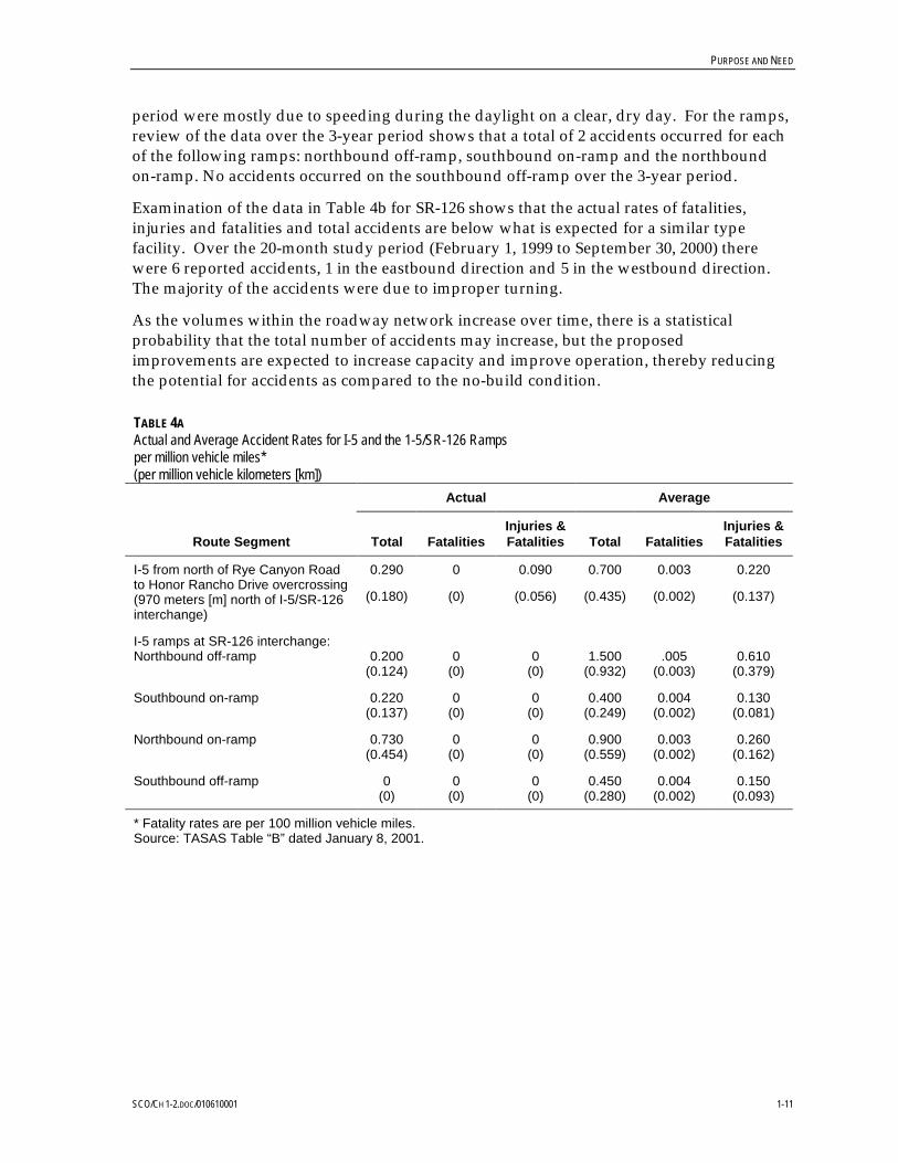
PURPOSE AND NEED
SCO/CH 1-2.DOC/010610001 1-11
period were mostly due to speeding during the daylight on a clear, dry day. For the ramps,review of the data over the 3-year period shows that a total of 2 accidents occurred for eachof the following ramps: northbound off-ramp, southbound on-ramp and the northboundon-ramp. No accidents occurred on the southbound off-ramp over the 3-year period.
Examination of the data in Table 4b for SR-126 shows that the actual rates of fatalities,injuries and fatalities and total accidents are below what is expected for a similar typefacility. Over the 20-month study period (February 1, 1999 to September 30, 2000) therewere 6 reported accidents, 1 in the eastbound direction and 5 in the westbound direction.The majority of the accidents were due to improper turning.
As the volumes within the roadway network increase over time, there is a statisticalprobability that the total number of accidents may increase, but the proposedimprovements are expected to increase capacity and improve operation, thereby reducingthe potential for accidents as compared to the no-build condition.
TABLE 4AActual and Average Accident Rates for I-5 and the 1-5/SR-126 Rampsper million vehicle miles*(per million vehicle kilometers [km])
Actual Average
Route Segment Total FatalitiesInjuries &Fatalities Total Fatalities
Injuries &Fatalities
I-5 from north of Rye Canyon Roadto Honor Rancho Drive overcrossing(970 meters [m] north of I-5/SR-126interchange)
0.290
(0.180)
0
(0)
0.090
(0.056)
0.700
(0.435)
0.003
(0.002)
0.220
(0.137)
I-5 ramps at SR-126 interchange:Northbound off-ramp
Southbound on-ramp
Northbound on-ramp
Southbound off-ramp
0.200(0.124)
0.220(0.137)
0.730(0.454)
0(0)
0(0)
0(0)
0(0)
0(0)
0(0)
0(0)
0(0)
0(0)
1.500(0.932)
0.400(0.249)
0.900(0.559)
0.450(0.280)
.005(0.003)
0.004(0.002)
0.003(0.002)
0.004(0.002)
0.610(0.379)
0.130(0.081)
0.260(0.162)
0.150(0.093)
* Fatality rates are per 100 million vehicle miles.Source: TASAS Table “B” dated January 8, 2001.

PURPOSE AND NEED
SCO/CH 1-2.DOC/010610001 1-12
TABLE 4BActual and Average Accident Rates for SR-126per million vehicle miles*(per million vehicle km)
Actual Average
Route Segment Total FatalitiesInjuries &Fatalities Total Fatalities
Injuries &Fatalities
SR-126 from Wolcott Way (800 mwest of Castaic Creek Bridge) to theI-5 interchange
0.520
(0.323)
0
(0)
0.090
(0.056)
0.650
(0.404)
0.022
(0.014)
0.290
(0.180)
* Fatality rates are per 100 million vehicle miles.Source: TASAS Table “B” dated May 14, 2001.
1.3 Project Status1.3.1 History of the Planning ProcessThe I-5/SR-126 Interchange Project was initiated with a Project Study Report (PSR). ThePSR is a project initiation document that is required for all major projects prior to theirbeing included in a state or local programming document such as the State TransportationImprovement Program (STIP). The outcome of the project initiation process is a projectscope tied to a reliable cost estimate and schedule suitable for programming or localcommitment and for proceeding to the environmental evaluation and project alternativeselection phase. The PSR documents agree on the design concept, design scope, schedule,and estimated cost of the project so that the project can be included in a futureprogramming document.
The PSR for this project was approved on May 5, 1999. A Preliminary EnvironmentalEvaluation Report (PEER) and hazardous waste Initial Site Assessment were preparedconcurrently with the PSR to identify the environmental issues and anticipatedenvironmental impacts of the proposed project. The PEER was completed in February 1999to meet Caltrans and California Environmental Quality Act (CEQA) requirements. AnEnvironmental Significance Checklist was prepared as part of the PEER and is included inthis Initial Study/Environmental Assessment (IS/EA) in Section 4.
1.3.2 Other Relevant DocumentsThere are several planned and ongoing projects within the vicinity of the proposed project.These projects, described in Section 2.3, have separate environmental documents thatevaluate their environmental impacts affecting the same general area as this proposedproject. These studies were reviewed, and relevant information has been incorporated intothis document. All relevant documents have been listed in the reference list in Section 8.

PURPOSE AND NEED
SCO/CH 1-2.DOC/010610001 1-13
1.4 Required Coordination and Applicable RegulatoryRequirements
Caltrans is the state Lead Agency for this IS/EA under CEQA; FHWA is the federal LeadAgency. In addition to direction provided by Caltrans and FHWA, ongoing projectcoordination has been provided through a Project Development Team (PDT). The PDT iscomposed of technical staff drawn from Caltrans, FHWA, Los Angeles County, ValenciaCompany, City of Santa Clarita, and the CH2M HILL consultant team. The PDT continuesto meet monthly throughout the course of the study to review progress of the study, toexchange technical information, and to respond to new issues affecting the project.
Consultation and coordination with a variety of other agencies have also been required.Among these are:
• Environmental Protection Agency (EPA)• Regional Water Quality Control Board• Native American Heritage Commissioner• U.S. Fish and Wildlife Service• California Department of Fish and Game• Southern California Association of Governments (SCAG)• South Coast Air Quality Management District (SCAQMD)• County of Los Angeles Planning Department• City of Santa Clarita Planning Department
Construction of the proposed project will require the following permits and associatedcoordination:
• State Water Resources Control Board Clean Water Act Section 401 Water QualityCertification

SCO/CH 1-2.DOC/010610001 2-1
2 Description of Proposed Project
2.1 Project DescriptionThe proposed project is located in Los Angles County, California, northwest of the City ofSanta Clarita. The project is between kilopost (KP) R6.8 and R9.7 (post mile [PM] R4.2 toR6.0) on SR-126, and between KP R88.0 and R90.4 (PM R54.7 to R56.2) on I-5 (Figure 1B).The interchange is located approximately 16 km (9.9 miles) north of the I-5/SR-14interchange.
Four alternatives were studied in the PSR (Valencia Company, 1999b), including a no-buildalternative and three build alternatives. Each of these alternatives included designs for theI-5/SR-126 interchange, as well as alternatives for constructing an interchange at theSR-126/Commerce Center Drive intersection, located 1.5 km (0.9 mile) to the west. Sincethat document was prepared, the decision was made to split the interchange improvementsinto two separate projects because each has distinct logical termini and has independentutility from the other. Of the four alternatives described in the PSR, two alternativeconfigurations, Alternatives A and C, for the I-5/SR-126 interchange are presented. Theproposed I-5/SR-126 configuration for Alternative B is identical to that of Alternative C; asa result, Alternative B is not discussed further in this document.
The estimated cost of this project is $22.5 million for Alternative C, the preferred alternative,and is expected to be funded jointly by Valencia Company and federal funding programsadministered through Los Angeles County Metropolitan Transportation Authority(LACMTA) or the State of California. For the fiscal year 2001-2002, $7.5 million in fundingwould come from LACMTA and $5.513 million from STIP funds. According to the 1998STIP, $5.513 million will be provided through the 1998 Interregional TransportationImprovement Program (ITIP) and $7.509 million will be provided through the 1998Regional Transportation Improvement Program (RTIP). The remainder of the project willbe funded by the Valencia Company.
2.2 Relationship to State, Regional, and Local TransportationPlanning
The proposed project is listed in the Regional Transportation Improvement Program (RTIP)for 2000/01 – 2005/06, as approved on October 6, 2000. As such, the project is consistentwith the 1998 Regional Transportation Plan (RTP) prepared by SCAG.
2.3 Other Local Projects and ProposalsSR-126 is currently used as a major route between I-5 and Ventura County to the west.During the next 20 years, the area around the I-5/SR-126 interchange is projected toexperience a build-out of major commercial and industrial developments, which would

DESCRIPTION OF PROPOSED PROJECT
SCO/CH 1-2.DOC/010610001 2-2
result in significant increases in regional and inter-regional traffic on these routes. Increasesin local traffic are also projected for the area due to ongoing construction and planneddevelopment within the Santa Clarita Valley. Additionally, several transportationimprovement projects within the Santa Clarita Valley would change traffic patterns,contributing additional traffic to the I-5/SR-126 interchange. These commercial/industrialdevelopments and local transportation improvement projects are discussed below.
1. Valencia Commerce Center Expansion. Valencia Company is developing 284 hectares(702 acres) northwest of the I-5/SR-126 interchange as a major industrial, office, andsupporting commercial-use center. Approximately 40 percent (113 hectares [280 acres])of the area is being preserved as open space and hillside management area. Despite thispreservation of open space, Valencia Commerce Center is forecast to grow from theexisting 200,000 square meters (49 acres) to approximately 1.2 million square meters (296acres) by the year 2020, resulting in a large employment center north of SR-126 atCommerce Center Drive. The build-out of Valencia Commerce Center would addapproximately 110,000 vehicle trips per day (Austin-Foust, 1998). A majority of driversmaking these trips would utilize SR-126, with a high proportion of those trips accessingI-5 through the I-5/SR-126 interchange.
An Environmental Impact Report (EIR) (Sikand, 1990) was finalized in April 1990. Itstated that the purpose of the proposed project is to develop a major expansion of theexisting Valencia Industrial Center, serving the growing business needs of the SantaClarita Valley and surrounding communities. The proposed project would result insignificant adverse impacts to the following environmental resource areas: geotechnicalresources, floodplain, cultural resources, biota, scenic resources, noise levels, air quality,sewage disposal, water service, traffic, fire service, sheriff service, environmental safety,and noise levels. With the implementation of mitigation measures discussed in the finalEIR, these effects would be mitigated to levels of insignificance, except for unavoidablesignificant impacts to air quality. Because air quality impacts could not be mitigated tolevels of insignificance, a Statement of Overriding Consideration was prepared (Sikand,1991). The development of Valencia Commerce Center was cleared environmentally andamended to the Local Plan in September 1991. A tentative parcel map for the area hasalso been approved.An Environmental Impact Report (EIR) (Sikand, 1990) was finalizedin April 1990. It stated that the purpose of the proposed project is to develop a majorexpansion of the existing Valencia Industrial Center, serving the growing businessneeds of the Santa Clarita Valley and surrounding communities. The proposed projectwould result in significant adverse impacts to the following environmental resourceareas: geotechnical resources, floodplain, cultural resources, biota, scenic resources,noise levels, air quality, sewage disposal, water service, traffic, fire service, sheriffservice, environmental safety, and noise levels. With the implementation of mitigationmeasures discussed in the final EIR, these effects would be mitigated to levels ofinsignificance, except for unavoidable significant impacts to air quality. Because airquality impacts could not be mitigated to levels of insignificance, a Statement ofOverriding Consideration was prepared (Sikand, 1991). The development of ValenciaCommerce Center was cleared environmentally and amended to the Local Plan inSeptember 1991. A tentative parcel map for the area has also been approved.

DESCRIPTION OF PROPOSED PROJECT
SCO/CH 1-2.DOC/010610001 2-3
2. Commerce Center Drive Extension and Bridge over Castaic Creek. As part of thedevelopment plans for Valencia Commerce Center, Valencia Company plans to improvethe traffic circulation within the area. The area currently has access from I-5 at HasleyCanyon Road, located north of SR-126. Planned access improvements, already underconstruction and partially completed, would result in an extension of Commerce CenterDrive southward from its previous terminus near Franklin Avenue, across a new bridgeover Castaic Creek, to form a signalized intersection with SR-126. These projects, nearthe Castaic Creek, were included in an approved final EIR (Sikand, 1990), discussedabove.
3. Newhall Ranch Road Connection. Newhall Ranch Road would be constructed fromeast of the northbound I-5 off-ramp as an ultimate six- to eight-lane (three to four lanesin each direction) city arterial, connecting to McBean Parkway. This connection toI-5/SR-126 would provide access to the Newhall Ranch development, a master-plannedcommunity located west of I-5, consisting of over 20,000 residential units and over464,000 square meters (115 acres) designated for commercial and industrial use. Thisproject was included in an amendment to the City of Santa Clarita Circulation Element,and was evaluated in a PEER (Valencia Company, 1998). The PEER determined thatthere were no significant environmental impacts, and a Categorical Exemption/Categorical Exclusion was filedand was evaluated in a PEER (Valencia Company, 1998).The PEER determined that there were no significant environmental impacts, and aCategorical Exemption/Categorical Exclusion was filed.
4. I-5/Hasley Canyon Road Interchange Project. Proposed development within ValenciaCommerce Center would generate additional traffic accessing I-5 at the I-5/HasleyCanyon Road interchange, located 1.6 km (0.99 mile) north of the I-5/SR-126interchange. The anticipated traffic increase would warrant improvements to theinterchange to reduce delay and to improve safety and traffic circulation. Improvementswould include realignment and reconstruction of the existing ramps and intersectionapproach widening.
An IS/EA (Valencia Company, 2000d) was released for public review in January 2001.The purpose of the proposed project is to:
• Increase capacity and improve local access and circulation• Improve the operation of the interchange• Incorporate planned infrastructure improvements• Enhance safety; an
a) Accommodate planned growth within the study area
The proposed project would result in adverse impacts to the following environmentalresource areas: water quality (i.e., siltation); floodplains; wetlands; air quality; noiselevels; light and glare; biological resources; and the transportation system. Aftermitigation, these impacts would be reduced to a level of insignificance.A Draft IS/EA(Valencia Company, 2000d) was released for public review in January 2001. The purposeof the proposed project is to:
a)increase capacity and improve local access and circulation;

DESCRIPTION OF PROPOSED PROJECT
SCO/CH 1-2.DOC/010610001 2-4
b)improve the operation of the interchange;c)incorporate planned infrastructure improvements;d)enhance safety; ande)accommodate planned growth within the study area.
The proposed project would result in adverse impacts to the following environmentalresource areas: water quality (i.e., siltation); floodplains; wetlands; air quality; noiselevels; light and glare; biological resources; and the transportation system. Aftermitigation, these impacts would be reduced to a level of insignificance.
5. I-5/Magic Mountain Parkway Interchange Project. Valencia Company, in cooperationwith City of Santa Clarita, County of Los Angeles, and Caltrans, is developingimprovement alternatives for the I-5/Magic Mountain Parkway interchange and forMagic Mountain Parkway from I-5 to McBean Parkway. The project would modify theI-5/Magic Mountain Parkway interchange, reconstruct the Santa Clara River Bridge,realign The Old Road, and realign and widen Magic Mountain Parkway from six toeight lanes.
An IS/EA (Tetra Tech, 2000) was finalized in July 2000, resulting in the approval of aFinding of No Significant Impact (FONSI) and Negative Declaration. The purpose of theproposed project is to:
• Improve traffic safety and the deficiencies of the existing roadway• Increase the capacity and improve the operation of existing roadways• Alleviate existing and future congestion• Conform to state, regional, and local plans and policies• Facilitate the flow of goods and services through the area• Ensure continued mobility of the public at the state, regional, and local level
The proposed project would result in adverse impacts to the following environmentalresource areas: (1) topography, geology, and soils; (2) use of nonrenewable resources;(3) hazardous materials; (4) hydrology, drainage, and water quality; (4) air quality;(5) noise levels; (6) light and glare; (7) biological resources; (8) land use; (9) traffic andtransportation; and (10) and construction-related impacts. There would be no significantimpacts resulting from the project; however, mitigation measures have beenrecommended for some environmental resources to ensure that no significant impactswould occurAn IS/EA (Tetra Tech, 2000) was finalized in July 2000, resulting in theapproval of a Finding of No Significant Impact (FONSI) and Negative Declaration. Thepurpose of the proposed project is to:
a)improve traffic safety and the deficiencies of the existing roadway;b)increase the capacity and improve the operation of existing roadways;c)alleviate existing and future congestion;d)conform to state, regional, and local plans and policies;e)facilitate the flow of goods and services through the area; andf)ensure continued mobility of the public at the state, regional, and local level.
The proposed project would result in adverse impacts to the following environmentalresource areas: (1) topography, geology, and soils; (2) use of nonrenewable resources;(3) hazardous materials; (4) hydrology, drainage, and water quality; (4) air quality;

DESCRIPTION OF PROPOSED PROJECT
SCO/CH 1-2.DOC/010610001 2-5
(5) noise levels; (6) light and glare; (7) biological resources; (8) land use; (9) traffic andtransportation; (10) and construction-related impacts. There would be no significantimpacts resulting from the project; however, mitigation measures have beenrecommended for some environmental resources to ensure that no significant impactswould occur.
6. I-5/Rye Canyon Road Ramp Improvement Project. Valencia Company is preparing afeasibility study to relocate the I-5/Rye Canyon Road hook ramps approximately 137 m(449 feet) to the north of their existing location, 1.6 km (0.99 mile) south of theI-5/SR-126 interchange. This improvement would include the installation of both atraffic signal and ramp and intersection approach widening, which would alleviateexisting traffic congestion and accommodate traffic diverted during the construction ofthe I-5/SR-126 and I-5/Magic Mountain Parkway interchange improvements. Thisproject is still in the planning stages, and a PEER is scheduled to be completed by spring2001. A Categorical Exemption/Categorical Exclusion is being soughtThis project is stillin the planning stages and a PEER is scheduled to be completed by spring 2001. ACategorical Exemption/Categorical Exclusion is being sought.
7. I-5/Valencia Boulevard Interchange Improvements. The proposed project wouldconsist of widening Valencia Boulevard through the interchange with I-5, modifying theramp configuration to improve overall operation of the interchange, replacing theexisting bridge, and constructing a new southbound direct on-ramp.
An IS/EA (Tetra Tech, 2000) was finalized in June 2000, resulting in the approval of aFONSI and Negative Declaration. The purpose of the proposed project is to:
• Improve traffic safety and the deficiencies of the existing roadway over I-5 and theinterchange
• Increase the capacity and improve the operation of existing roadways
• Alleviate existing and future congestion
• Conform to state, regional, and local plans and policies
• Facilitate the flow of goods and services through the area
• Ensure continued mobility of the public at the state, regional, and local level
The proposed project would result in adverse impacts to noise levels, air quality, waterquality, and plants and animal life; although impacts to water quality, noise levels, andair quality would not be significant. After mitigation, impacts to biological resourceswould not be significant.An IS/EA (Tetra Tech, 2000) was finalized in June 2000,resulting in the approval of a FONSI and Negative Declaration. The purpose of theproposed project is to:
a)improve traffic safety and the deficiencies of the existing roadway over I-5 and theinterchange;
b)increase the capacity and improve the operation of existing roadways;
c)alleviate existing and future congestion;

DESCRIPTION OF PROPOSED PROJECT
SCO/CH 1-2.DOC/010610001 2-6
d)conform to state, regional, and local plans and policies;
e)facilitate the flow of goods and service through the area; and
f)ensure continued mobility of the public at the state, regional, and local level.
The proposed project would result in adverse impacts to noise levels, air quality, waterquality, and plants and animal life, although impacts to water quality, noise levels, andair quality would not be significant. After mitigation, impacts to biological resourceswould not be significant.
8. Caltrans’ Newhall Maintenance Station. In addition to these roadway projects,Caltrans recently completed construction of a new maintenance facility (NewhallMaintenance Station) between The Old Road and I-5, south of SR-126. This project is notexpected to significantly increase traffic volumes or create traffic delays within theI-5/SR-126 Interchange Project vicinity. An Initial Study (Caltrans, 1993) was prepared,resulting in the approval of a Negative Declaration. The purpose of the proposed projectis to:
• Relocate the maintenance station to an area with more compatible surrounding landuses
• Provide easier access for maintenance vehicles and employees
• Reduce the crowded conditions at the existing facility
8.The proposed project was found to have less-than-substantial impacts to naturalfeatures including, but not limited to, plant life, animal life, sensitive habitats, andanimal movements. Additionally, the proposed project would have no significantimpacts on the environmentAn Initial Study (Caltrans, 1993) was prepared, resulting inthe approval of a Negative Declaration. The purpose of the proposed project is to:
a)relocate the maintenance station to an area with more compatible surrounding landuses;
b)provide easier access for maintenance vehicles and employees; and
c)reduce the crowded conditions at the existing facility.
The proposed project was found to have less-than-substantial impacts to naturalfeatures including, but not limited to, plant life, animal life, sensitive habitats, andanimal movements. Additionally, the proposed project would have no significantimpacts on the environment.
9. Santa Clara River Bridge Replacement on I-5. Major degradation of the Santa ClaraRiverbed surrounding the I-5 bridge pilings has occurred as a result of scour andupstream mining. Additionally, the bridge also has indications of structural problems.As a result, Caltrans prepared an Environmental Impact Report/EnvironmentalAssessment (EIR/EA) (Caltrans, 2000a), which was finalized in June 2000. In thatdocument, Caltrans proposes to replace the existing bridge to achieve thefollowing objectives:As a result, Caltrans prepared an Environmental ImpactReport/Environmental Assessment (EIR/EA) (Caltrans, 2000), which was finalized in

DESCRIPTION OF PROPOSED PROJECT
SCO/CH 1-2.DOC/010610001 2-7
June 2000. In that document, Caltrans proposes to replace the existing bridge to achievethe following objectives:
• Replace a scour susceptible bridge• Ensure continued mobility of the public at the state, regional, and local level• Facilitate the efficient flow of goods and services through the area• Improve traffic safety
a)replace a scour susceptible bridge;b)ensure continued mobility of the public at the state, regional, and local level;c)facilitate the efficient flow of goods and services through the area; andd)improve traffic safety.
The bridge replacement would result in the reduction of habitat for endangered speciesand result in a barrier to the migration or movement of animals. While impacts to allspecies cannot be fully mitigated, mitigation measures would reduce the level of impactto less than significantThe bridge replacement would result in the reduction of habitatfor endangered species and result in a barrier to the migration or movement of animals.While impacts to all species cannot be fully mitigated, mitigation measures wouldreduce the level of impact to less than significant.
10. SR-126/Commerce Center Drive Interchange Project. Valencia Company has proposedto construct a grade-separated interchange at the existing, signalized intersection ofSR-126 and Commerce Center Drive. The project would also result in thereconfiguration of the existing Henry Mayo Drive/Commerce Center Drive intersectionfurther to the south. The project would increase capacity of the interchange; improvelocal access and circulation; incorporate planned infrastructure improvements; enhancesafety; and accommodate planned growth within the area.
IS is being prepared but has not yet been released for public or agency review. Theproject is anticipated to result in adverse impacts to the Santa Clara River floodplain,noise levels, air quality, water quality, biological resources, and farmland. The level ofsignificance cannot be ascertained until after the completion of the environmentaldocument.An Initial Study (IS) is being prepared but has not yet been released forpublic or agency review. The project is anticipated to result in adverse impacts to theSanta Clara River floodplain, noise levels, air quality, water quality, biologicalresources, and farmland. The level of significance cannot be ascertained until after thecompletion of the environmental document.
As a result of these planned commercial/industrial developments and transportationimprovement projects, the existing I-5/SR-126 Interchange is expected to experiencesignificant increases in traffic. Both Valencia Company and Caltrans recognize the need toaccommodate both the future development and projected increases in traffic, toaccommodate increased inter-regional growth and traffic, and to improve circulation in thearea and enhance safety at this interchange. To accomplish this, Valencia Company, incooperation with FHWA, Caltrans, City of Santa Clarita, and Los Angeles County, isproposing that the I-5/SR-126 Interchange be reconstructed and reconfigured. Theproposed improvements would increase capacity, improve operations, provide additionalinterchange movements, improve local access and circulation, incorporate planned

DESCRIPTION OF PROPOSED PROJECT
SCO/CH 1-2.DOC/010610001 2-8
infrastructure improvements, enhance safety, and accommodate planned growth within thestudy area. Without these improvements, severe congestion would occur due to theexpected increase in the average daily and peak-hour traffic volumes on I-5 and SR-126(Table 2).
2.4 Alternatives2.4.1 No-Build AlternativeThe existing I-5/SR-126 interchange is a partial interchange with a northbound loop rampfrom eastbound SR-126 to northbound I-5, a diamond off-ramp from northbound I-5 towestbound SR-126, and directional ramps from southbound I-5 to westbound SR-126 andeastbound SR-126 to southbound I-5 (Figure 5). The westbound to northbound movement isaccommodated via a left turn onto the loop ramp. The existing interchange does notprovide direct access from Newhall Ranch Road to southbound I-5, or from southbound I-5to eastbound Newhall Ranch Road. Indirect access is provided via Rye Canyon Road hookramps, located 1.6 km (0.99 mile) south of the I-5/SR-126 interchange.
Three projects are under construction or about to begin, but are not yet in operation. Theywould, however, be operational when the proposed project would begin construction;therefore, as part of the baseline condition, these projects are part of the No-BuildAlternative and are listed below:
• The southbound extension of Commerce Center Drive to SR-126 and construction of asignalized at-grade intersection with access to Henry Mayo Drive
• The construction of Newhall Ranch Road as the easterly extension of SR-126 east of theI-5 northbound off-ramp
• Removal of access to Avenue Stanford from SR-126
The No-Build Alternative would preclude construction-related impacts associated with theproposed improvements to the I-5/SR-126 interchange, and there would be no constructioncosts associated with this alternative. Additionally, no right-of-way acquisitions would berequired for the No-Build Alternative. However, the No-Build Alternative would not meetthe project purpose and need, as discussed in Sections 1.1 and 1.2, for the following reasons(refer to Section 5.11 for a detailed discussion on the no-build traffic):
• The No-Build Alternative, which results in a LOS F, would not accommodate localcirculation and access needs or alleviate congestion and capacity deficiencies.
• It would not be consistent with local and regional planning that calls for an ultimate6- to 8-lane cross section on SR-126.
• It would not accommodate the forecasted traffic volumes (4,300 vehicles), whichexceeds the capacity of the existing facility, thus resulting in an increase in trafficcongestion, delay, fuel consumption, and vehicle emissions.
• It would not meet current FHWA or Caltrans standards, which indicate that travelmovement be accommodated in all directions at freeway interchanges.

DESCRIPTION OF PROPOSED PROJECT
SCO/CH 1-2.DOC/010610001 2-9
Insert
Figure 5 No-Build Alternative

DESCRIPTION OF PROPOSED PROJECT
SCO/CH 1-2.DOC/010610001 2-10
2.4.2 Alternative A −−−− I-5/SR-126 Diamond Interchange ConceptThis alternative proposes the construction of a directional ramp in the northeast quadrant ofthe I-5/SR-126 interchange to accommodate vehicles traveling westbound on NewhallRanch Road accessing northbound I-5 (Figure 6). This movement is currentlyaccommodated via a left turn onto the loop ramp. This ramp would provide a two-lanediverge from westbound Newhall Ranch Road and would narrow to one lane before joiningnorthbound I-5.
Modification of the existing I-5 northbound off-ramp would include widening the ramp totwo lanes, widening the intersection approach to four lanes to provide one right- and threeleft-turn lanes at the intersection, and installation of a traffic signal. Modification of the loopramp from eastbound SR-126 to northbound I-5 would include the elimination of theconnection from westbound Newhall Ranch Road and restriping of the traveled way toprovide a wider lane to accommodate trucks.
This alternative would reconfigure the existing southbound I-5 directional ramp to SR-126as a diamond ramp. The southbound off-ramp from I-5 would be widened to two lanes.Approaching SR-126, the two-lane off-ramp would be widened to four lanes, providingdual right- and left-turn lanes. The intersection would be controlled by a traffic signal,which would eliminate weaving conflicts on westbound SR-126.
The eastbound SR-126 to southbound I-5 directional ramp would be widened to two lanesto accommodate the heavy eastbound-to-southbound volume. Traffic from westboundNewhall Ranch Road would access the southbound I-5 directional ramp by turning left atthe signalized intersection and merging on the left with traffic on the eastbound SR-126 tosouthbound I-5 directional ramp.
SR-126 would be widened to four through lanes in each direction. East of the I-5/SR-126interchange, the widening would go to Newhall Ranch Road. At the intersection with thenorthbound off-ramp, Newhall Ranch Road would be widened to four lanes and then taperto match the existing roadway east of Vanderbilt Way. SR-126, to the west of the I-5/SR-126interchange, would be widened before tapering to two lanes to match the existing roadway.A standard concrete barrier would be constructed in the median to separate the eastboundand westbound lanes of SR-126.
Alternative A would address the purpose and need of the project in the following areas(refer to Section 5.11 for a detailed discussion on the proposed project traffic):
• It would provide full interchange movements, with the addition of the new rampconnections, to meet FHWA and Caltrans standards.
• It would be consistent with local and regional planning by accommodating localcirculation and access needs.
• It would alleviate congestion and capacity deficiencies by widening SR-126 to itsultimate condition.
• It would accommodate the forecasted area build-out and the resultant increases intraffic volumes to LOS C, as compared to LOS F with the no-build condition.

DESCRIPTION OF PROPOSED PROJECT
SCO/CH 1-2.DOC/010610001 2-11
Insert
Figure 6 Alternative A

DESCRIPTION OF PROPOSED PROJECT
SCO/CH 1-2.DOC/010610001 2-12
2.4.3 Alternative C −−−− I-5/SR-126 Partial Cloverleaf A Interchange ConceptThis alternative proposes the construction of a directional ramp in the northeast quadrant ofthe I-5/SR-126 interchange (similar to Alternative A) to accommodate vehicles travelingwestbound on Newhall Ranch Road accessing northbound I-5 (Figure 7). This ramp wouldprovide two lanes at the divergence from Newhall Ranch Road to accommodate westboundexiting traffic, which would then narrow to one lane before joining northbound I-5.Construction of this directional ramp would eliminate the existing left-turn movement fromwestbound Newhall Ranch Road to the eastbound-to-northbound loop on-ramp.
The I-5 northbound off-ramp to SR-126 would be widened to two lanes. ApproachingSR-126, the ramp would flare to four lanes and would provide three left- and one right-turn lane.
To provide access for westbound traffic from Newhall Ranch Road to I-5 south,Alternative C proposes the construction of a loop on-ramp to I-5 in the northwest quadrantof the I-5/SR-126 interchange. The existing southbound off-ramp would be realigned/reconstructed, and the diverging end would be relocated further to the north to allow forthe construction of this loop ramp.
The southbound I-5 off-ramp to SR-126 would be widened to four lanes approaching theintersection with two right- and two left-turn lanes. The southbound-to-eastbound left-turnlane would be accommodated through a two-phase traffic signal at this intersection. Theright-turn lanes would be controlled by the signal to eliminate potential westboundweaving conflicts between the southbound off-ramp and the future off-ramp toCommerce Center Drive.
The eastbound SR-126 to southbound I-5 ramp would be a two-lane connector ramp toaccommodate heavy eastbound-to-southbound volume. Where the ramp merges withsouthbound I-5, the right lane of the connector would be dropped, and an auxiliary lanewould be added to the southbound mainline. The auxiliary lane would extend to thesouthbound off-ramp to The Old Road, north of Rye Canyon Road.
SR-126 would be widened as described for Alternative A.
Alternative C would require 5,250 square meters of right-of-way in the northwest quadrantof the I-5/SR-126 interchange. The needed area is undeveloped land located in one parcel,which is owned by Newhall Land & Farming Company, of which Valencia Company is asubsidiary. In addition, with the abandonment of the existing eastbound and westboundhook ramps along SR-126, there is an excess right-of-way of 27,538 square meters. A post-2020 plan for the addition of a northbound-to-westbound flyover and a southbound-to-westbound connector requires that approximately 15,000 square meters of right-of-waywould be needed at that time. This future right-of-way need would be reserved at this time.Valencia Company would donate all needed right-of-way for construction of theinterchange. Further analysis of right-of-way issues, including the possible exchange for theexcess right-of-way, would continue during the detailed design of the project.
Overall, under this alternative there are no relocations, partial or full acquisitions ofproperty not owned by Newhall Land & Farming Company, or any other major right-of-way-related issues.

DESCRIPTION OF PROPOSED PROJECT
SCO/CH 1-2.DOC/010610001 2-13
Figure 7 Alternative C

DESCRIPTION OF PROPOSED PROJECT
SCO/CH 1-2.DOC/010610001 2-14
Alternative C would address the project’s purpose and need in the following areas (refer toSection 5.11 for a detailed discussion on the proposed project traffic):
• It would provide full interchange movements, with the addition of the new rampconnections, to meet FHWA and Caltrans standards.
• It would be consistent with local and regional planning by accommodating localcirculation and access needs.
• It would alleviate congestion and capacity deficiencies by widening SR-126 to itsultimate condition.
• It would accommodate the forecasted area build-out and the resultant increases intraffic volumes to LOS C, as compared to LOS F with the no-build condition.
Based on the following operational and safety benefits, Alternative C is preferred overAlternative A:
• Alternative C eliminates the westbound-to-southbound left turn at the I-5/SR-126interchange, which improves operations (reduces delay) at the southbound rampterminal intersection by constructing a free-flow loop.
• The eastbound SR-126 to southbound I-5 has been designed as a two-lane connector inAlternative C with an auxiliary lane along I-5 to the Rye Canyon Road exit ramp. Theauxiliary lane reduces weaving conflicts and improves southbound I-5 mainlineoperations.

SCO/CH 3.DOC/010610003 3-1
3 Affected Environment
3.1 Topography and GeologyThe I-5/SR-126 interchange is located in northern Los Angeles County. The area isgenerally defined by significant mountain ridges of the San Gabriel, Santa Susana, andSierra Pelona Mountains, in addition to several canyons, valleys, and the Santa Clara Riverand Castaic Creek beds. The Santa Clara River originates approximately 31 miles east-southeast of the project site in the San Gabriel Mountains. Castaic Creek originatesapproximately 27 km (17 miles) north of the project site in the Angeles National Forest.These two drainage courses merge approximately 3.2 km (2 miles) southwest of theI-5/SR-126 interchange.
The climate of the area can be classified as “valley marginal”; the average annualprecipitation varies between 10 and 40 inches (25.4 and 101.6 centimeters [cm]) per year(City of Santa Clarita, 1997). Winter storms from the northwest account for 90 percent of therainfall in the area, with summer thunderstorms from tropical depressions accounting forthe rest.
The project area is underlain by sedimentary bedrock of the Saugus Formation. Overlyingthe bedrock are terrace deposits, alluvium, slopewash, and artificial fills. The Holser andSan Gabriel Faults are the closest faults to the I-5/SR-126 interchange.
3.2 Land Use and PlanningThe proposed project is located in a fast-growing area within unincorporated Los AngelesCounty northwest of the City of Santa Clarita, in the northwest portion of the Santa ClaritaValley. To the southeast of I-5/SR-126 is the community of Valencia, within the City ofSanta Clarita. Valencia is a master-planned community that is being developed inaccordance with a plan that was designed in the early 1960s to create a unified urbanenvironment on property owned by Newhall Land and Farming Company.
3.2.1 Existing Land UsesIn general, current land use patterns west of I-5 reflect a mixture of open space, urban, andrural (Figure 8). The immediate project area has commercial and industrial properties;agriculture uses; and vacant land consisting of either undeveloped commercial/industrialareas, hills, or floodplains. There are no residential properties within the proposed projectarea.
The surrounding urbanized development supports a variety of commercial and industrialbusinesses within Valencia Commerce Center, located northwest of the I-5/SR-126interchange, and Rye Canyon Business Center, located southeast of the interchange.Development of both commercial areas is ongoing. Valencia Commerce Center is a majorexpansion of Valencia Industrial Center on approximately 581 hectares (1,436 acres). It
AFFECTED ENVIRONMENT
SCO/CH 3.DOC/010610003 3-2
includes 284 hectares (702 acres) of industrial park, with approximately 102 hectares(10,990,000 square feet) of industrial space, 12 hectares (30 acres) of general commercialarea, and 36.8 hectares (91 acres) of office park. The area also has plans for a 4.5-hectare(11-acre) recreational area, jogging trails, and an equestrian trail. Rye Canyon BusinessCenter is situated on approximately 152 hectares (377 acres), with more than 20 buildingstotaling approximately 4.4 hectares (475,127 square feet).
There are no public utilities or facilities within the project vicinity. A newly constructedCaltrans Maintenance Facility is located in the southeast quadrant of the I-5/SR-126interchange, east of The Old Road. No pedestrian or bicycle facilities are located within thearea, and there are no future plans for these facilities in the area.
3.2.2 Proposed DevelopmentsThere are no plans for new residential, commercial, or industrial developments within theproposed project area. However, Valencia Commerce Center and Rye Canyon BusinessCenter are currently developing planned expansions immediately outside of the projectarea, as discussed in Section 2.3. In addition, to the west of the project area, the NewhallRanch specific plan details the addition of a major residential and commercial development.The City of Santa Clarita is also developing plans for the North Valencia Annexationproject. This project would involve the annexation of 347 hectares (858 acres) of land intothe City of Santa Clarita and approval for a mixed residential, commercial, office, industrial,conservation, and recreation development project.
3.2.3 Local and Regional Land Use PlansThe proposed project is located within the jurisdiction of Los Angeles County. As such, theproposed project is subject to the General Plan policies and Zoning Ordinances ofLos Angeles County. Policies of the General Plan are presented in the Santa Clarita ValleyArea Plan, developed in 1984 and amended in 1990.
The Santa Clarita Valley Area Plan is a portion of the Los Angeles County General Plan,which provides a framework to guide decisionmakers in developing policies for theunincorporated areas of the Santa Clarita Valley. The following policies from theSanta Clarita Valley Area Plan are relevant to the proposed project:
Land Use Element
Policy 9.4 − Encourage the development of a public transportation system tomeet resident requirements for access to public and private services,employment, and activity centers consistent with demand.
Economic Development Element
Policy 1.3 – Support infrastructure improvements in appropriate locationsthat contribute to development or expansion of employment producing uses.
Circulation Element
Policy 2.1 – Encourage the State of California to improve the capacity of theGolden State and Antelope Valley Freeways as traffic volumes dictate.

AFFECTED ENVIRONMENT
SCO/CH 3.DOC/010610003 3-3
Route 126 from the Antelope Valley Freeway to the Ventura Countyboundary is also recommended for construction as an expressway.
Policy 2.3 – Encourage the State of California to expand the access to thefreeway system as needed to serve the area and to maximize freewaycapacity.
The City of Santa Clarita has its own General Plan (1991), which provides guidance for thedevelopment of the City. The following policy from the City of Santa Clarita General Plan isalso relevant to the proposed project:
Land Use Element
Policy 7.1 – Ensure demand for public facilities and services does not exceedthe ability to provide and maintain such facilities and services; necessaryfacility improvements should precede or be coordinated with futuredevelopment.
3.3 FarmlandCultivated farmland, consisting of a variety of row crops, is located west of I-5 betweenSR-126 and Henry Mayo Drive. This land has been classified as both prime farmland andfarmland of statewide importance by the U.S. Department of Agriculture, NaturalResources Conservation Service, as required by the Farmland Protection Policy Act (FPPA)in 1981. Uncultivated land that is also classified as prime farmland and farmland ofstatewide importance is also located within the proposed project area. These areas areshown in Figure 9.
3.4 Social and Economic Conditions3.4.1 PopulationBoth Los Angeles County and the City of Santa Clarita have experienced rapid populationgrowth over the past several decades, facilitated by construction of a major freewaynetwork and the gradual migration of large-scale employers into northern Los AngelesCounty. Since incorporation, the nearby City of Santa Clarita has continued to grow at arelatively rapid rate. The city is currently home to about 131,000 residents and is expected togrow to over 188,000 by 2020, representing a 1.6 percent average annual growth rate.
3.4.2 HousingThe Santa Clarita Valley’s rapid growth is expected to continue until current economic orhousing conditions change. The valley is perceived as a very attractive place to live, andthere is a strong housing market (Valencia Company, 1999c). Growth in the number ofhousing units within the Santa Clarita Valley is supported by the goals of the Santa ClaritaArea Plan and the City’s General Plan, which seek to create a balance of jobs and housing.At the present time, the area is housing rich, but job poor. The County’s Santa Clarita AreaPlan includes approximately 404.6 hectares (10,000 acres) of proposed new developmentoutside the City of Santa Clarita. Most of this land is planned for single- and multiple-

AFFECTED ENVIRONMENT
SCO/CH 3.DOC/010610003 3-4
family residences, although significant areas are planned for the needed industrial andcommercial land uses.

AFFECTED ENVIRONMENT
SCO/CH 3.DOC/010610003 3-5
Figure 8- Land Uses

AFFECTED ENVIRONMENT
SCO/CH 3.DOC/010610003 3-6
Figure 9 Farmland

AFFECTED ENVIRONMENT
SCO/CH 3.DOC/010610003 3-7
3.4.3 EmploymentAlthough the Santa Clarita Valley is largely recognized as a suburban residentialcommunity, the City of Santa Clarita and surrounding development within the jurisdictionof Los Angeles County includes a diversity of employment opportunities. The largestemployers in the area include Six Flags Magic Mountain (3,000 employees), Henry MayoNewhall Memorial Hospital (1,072 employees), and the William S. Hart Unified SchoolDistrict (650 employees). The local labor force of about 43,000 is employed in a range ofoccupations. The largest occupational types include professional/technical (20.2 percent ofthe labor force), management (17.2 percent), clerical (16.8 percent), and sales (14.3 percent).
Valencia Commerce Center is located northeast of the I-5/SR-126 interchange. As discussedin Section 2.3, it is a major expansion of Valencia Industrial Center and is forecast to growfrom the existing 20 hectares (49.9 acres) to approximately 120 hectares (296.5 acres) by theyear 2020.
3.5 Air QualityThe project area is located in the South Coast Air Basin (SCAB), a coastal plain withconnecting broad valleys and low hills, bounded by the Pacific Ocean to the southwest andhigh mountains to the north and east. The climate of SCAB is mild, tempered by cool seabreezes. With light average wind speeds, the atmosphere of SCAB has a limited capabilityto disperse air contaminants horizontally. During periods of air stagnation, pollutantsremaining in SCAB are trapped and accumulate. Vertical dispersion of pollutants ishampered by the presence of a persistent inversion layer (typically 0.61 km [2,000 feet] orless above sea level). Pollutants released to the atmosphere at or near ground level tend toform a uniform mixture between the ground and inversion layer base (SCAQMD, 1993).
The potential for high pollution levels varies seasonally for many contaminants. In thesummer, reaction between reactive organic compounds (ROC) and oxides of nitrogen (NOX)can form photochemical oxidants, mainly ozone. In the winter, high levels of NOX can existbecause of extremely low inversions, air stagnation during the late night and early morninghours, and the lack of intense sunlight that is needed for photochemical reactions. Whenstrong inversions are formed on winter nights and are coupled with near-calm winds,carbon monoxide from automobile exhausts becomes highly concentrated. During thespring and summer, when fairly deep marine layers are frequently found in SCAB, sulfateconcentrations are at their peak (SCAQMD, 1993).
SCAQMD operates a network of ambient monitoring stations within SCAB. The I-5/SR-126interchange lies within SCAB located in the southwestern portion of the state, whichincludes the greater Los Angeles metropolitan area. The nearest representative monitoringstation for this project is located in Santa Clarita. Table 5 lists the pollutant levels recordedat this station from 1994 to 1996. The area is classified as nonattainment for ozone, carbonmonoxide (CO), and respirable particulate matter (PM10) and as shown in the table, ozoneand PM10 exceeded the California standard on at least 5 occasions during each of these3 years. Concentrations of sulfur dioxide, sulfates, lead, and visibility-reducing particleswere not measured at this station; however, this area was either classified as “attainment”or “unclassified” for these four components in 1998 (CARB, 1999).

AFFECTED ENVIRONMENT
SCO/CH 3.DOC/010610003 3-8
TABLE 5Summary of Ambient Monitoring Levels at the Santa Clarita Station
Pollutant Averaging Time 1994 1995 1996
CO (parts per million [ppm]) 1-Hour8-Hour
8 (0)3.9 (0)
7 (0)4.1 (0)
7 (0)3.9 (0)
Ozone (ppm) 1-Hour 0.26 (118) 0.21 (71) 0.17 (68)
Nitrogen Dioxide (ppm) Annual Average1-Hour
0.0320.12 (0)
0.0300.16 (0)
NA aNA a
PM10 (micrograms per cubic meter[µg/m3])
Annual Geometric MeanAnnual Arithmetic Mean24-Hour
31.7 b
35.8 b66 (13) c
31.237.0
87 (13) c
29.633.1
91 (5) c
a Nitrogen dioxide was not measured at this site in 1996.b Data presented are valid but incomplete in that an insufficient number of valid data points were collected tomeet EPA and/or Air Resources Board (ARB) criteria for representativeness.c 24-hour PM10 samples were collected on 58 days in 1994, 61 days in 1995, and 53 days in 1996.Notes:Hydrogen sulfide, vinyl chloride, and visibility-reducing particles are not monitored in SCAB.() = number of days in which a violation of either the state or national standard, whichever is more stringent, wasrecorded during the year.Source: California Air Resources Board, California Air Quality Data, Annual Summaries, 1994-1996.
3.6 Water Resources3.6.1 Surface WaterThe proposed project is located within the vicinity of the Santa Clara River, whichoriginates in Soledad Canyon in the San Gabriel Mountains, approximately 50 km (31 miles)east-southeast of the project site. The river drains an area of about 103.6 square km (400square miles) at its confluence with Castaic Creek. Within the project area, the river flowswest, crossing I-5 south of the I-5/SR-126 interchange, to the coast where it drains into thePacific Ocean near the City of San Buenaventura. The Santa Clara River is not a wild orscenic river, as designated by the National Wild and Scenic Rivers System (National ParkService, National Wild and Scenic Rivers System, 1999).
In the project vicinity, the Santa Clara River is a permanent stream with highly seasonalflows ranging from 1.1 to 2.0 cubic meters per second (cms) (40 to 70 cubic feet per second[cfs]) during the winter months, and less than 0.8 cms (3 cfs) during the low-flow, summerseason (USGS, Water Resources Data, Santa Clara River at Saugus). Total annualprecipitation in the area averages approximately 45 cm (18 inches) per year, with almost allprecipitation in the November through March period (National Weather Service, 1999).
The County of Los Angeles has designated the Santa Clara River as a Significant EcologicalArea (SEA). This designation was made due to the presence of habitat for several special-status species, discussed in Section 3.8.3.
The project area is not located within the coastal zone management program area, and nocoastal barriers are located within the project area.

AFFECTED ENVIRONMENT
SCO/CH 3.DOC/010610003 3-9
3.6.2 GroundwaterThe proposed project is located within the Eastern Groundwater Basin of the Santa ClaraRiver Valley Basin. The Basin includes alluvial sediments along the river and its tributaries,and deeper Saugus Formation sediments that underlie the alluvium. Depth to water in thealluvial aquifer varies greatly due to the seasonal and long-term variation in the amount ofrecharge and discharge.
The Los Angeles Regional Water Quality Control Board (RWQCB) has designated fourexisting beneficial uses for groundwater in the project area. These include municipal/domestic water supply, industrial service supply, industrial process supply, andagricultural supply. The majority of water extraction within the Santa Clarita Valley occursalong the Santa Clara River. The largest groundwater user in the project area is NewhallLand and Farming Company, which operates 25 to 30 wells primarily for agriculturalpurposes. Several other private water purveyors also extract groundwater for municipaland industrial uses. These include Los Angeles County Waterworks District No. 35 (for theWayside Honor Rancho), Santa Clarita Water Company, Newhall County Water District,and Valencia Water Company. Total groundwater extractions by the purveyors from thealluvial aquifer ranged between 9.7 to 17 cubic meters (12,000 to 21,000 acre-feet) from 1987to 1994 (Castaic Lake Water Agency, 1996).
3.7 WetlandsUnder Section 404 of the Clean Water Act, the U.S. Army Corps of Engineers (ACOE)regulates the discharge of fill and dredged material into “waters of the United States,”which are broadly defined in 33 Code of Federal Regulations (CFR) 328.3(a). The limits ofACOE 404 jurisdiction are defined as the ordinary high water mark, unless adjacentwetlands are present. The term “ordinary high water mark” means the line on the shore oredge of a channel established by the fluctuation of water and indicated by physicalcharacteristics such as a clear natural line impressed on the bank, shelving, destruction ofvegetation, debris, etc. The Final Environmental Impact Statement/Environmental ImpactReport (EIS/EIR) for the 404 Permit and 1603 Permit for Portions of the Santa Clara Riverand Its Tributaries (U.S. Army Corps of Engineers and California Department of Fish andGame, 1998) discussed the delineation of wetlands in the vicinity of this proposed project.In that document, ACOE and the applicant agreed to the limits of the jurisdiction of ACOEfor the analysis of the EIS/EIR. The proposed project is located well outside thejurisdictional wetland boundary determined in that document.
A recent (September 1999) biological constraints survey was conducted for this proposedproject. As part of the constraints survey, a search of available, relevant literature wasconducted for the proposed project area; and a survey of the project site was alsoconducted. There were no indications of wetlands within the proposed project area.
3.8 Vegetation and Wildlife ResourcesAs discussed above, a biological constraints survey was conducted for this proposedproject. The findings of this survey are summarized below. Additionally, there are nofisheries within the project area.

AFFECTED ENVIRONMENT
SCO/CH 3.DOC/010610003 3-10
3.8.1 VegetationVegetation within the study area includes mixed sage scrub, California annual grassland,mixed sage scrub/California grassland ecotone, disturbed/ruderal, ornamental, anddeveloped.
The mixed sage scrub vegetation type is located on the hills to the east of I-5. The dominantspecies within this vegetation type include California sagebrush (Artemisia californica), blacksage (Salvia mellifera), buckwheat (Eriogonum fasciculatum), and Our Lord’s candle (Yuccawhipplei). Other species present include bush sunflower (Encelia californica), fourwingsaltbush (Atriplex canescens ssp. canescens), cudweed aster (Lessingia filaginifolia), giant wildrye (Leymus condensatus), deerweed (Lotus scoparius), California matchweed (Gutierreziacalifornica), black mustard (Brassica nigra), and foxtail chess (Bromus madritensis ssp. rubens).
The mixed sage scrub/California grassland ecotone is located on one spot in the I-5 right-of-way. This habitat is an isolated patch of mixed sage scrub species with an understory ofannual grasses.
California annual grassland is located primarily on the lower slopes of the hills and on theflat areas below the hills east of I-5. The dominant species in these areas consist of non-native, invasive species such as foxtail chess (Bromus madritensis ssp. rubens), black mustard,Mediterranean schismus (Schismus barbatus), and puncture vine (Tribulus terrestris).
Disturbed/ruderal areas are typically located adjacent to roads and other developed areas.These areas are primarily composed of bare ground with a low density of non-native andweedy species. Species within this vegetation type include prickly lettuce (Lactuca serriola),telegraph weed (Heterotheca grandiflora), tree tobacco (Nicotiana glauca), common purslane(Portulaca oleracea), chaparral nightshade (Solanum xanti), western ragweed (Ambrosiapsilostachya), mustard (Brassica sp.), western sunflower (Helianthus annuus), Russian thistle(Salsola australis), sand wash butterweed (Senecio flaccidus var. douglasii), jimsonweed (Daturawrightii), California croton (Croton californicus), slender oat (Avena sp.), doveweed(Eremocarpus setiger), Bermuda grass (Cynodon dactylon), and Mexican elderberry (Sambucusmexicana). Non-native plant species that are present within the project area are commonwithin areas in Southern California (such as existing freeway interchanges) that have beensubject to past disturbance. The proposed project is not expected to substantially increasethe occurrence of these weeds outside the project limits.
Ornamental species, windrows, and remnant native trees along roads include Fremontcottonwood (Populus fremontii ssp. fremontii), Mexican elderberry, mulberry (Morus sp.), gum(Eucalyptus sp.), liquidambar (Liquidambar sp.), pampas grass (Cortaderia sp.), London planetree (Platanus acerifolia), Peruvian pepper tree (Schinus molle), flowering plum (Prunus sp.),western sycamore (Platanus racemosa), and ash (Fraxinus sp.).
Developed areas and agricultural fields contain little vegetation. Agricultural fields withinthe study area are currently active and are located west of I-5 both north and south ofSR-126. Disturbed/ruderal areas surround the fields. Developed areas include both officebuildings and roads throughout the study area. Developed areas are surrounded bydisturbed/ruderal or ornamental vegetation.

AFFECTED ENVIRONMENT
SCO/CH 3.DOC/010610003 3-11
3.8.2 Wildlife HabitatThe vegetation types within the study area provide habitat for a host of wildlife species.Common bird species observed during the survey included great blue heron (Ardeaherodias), red-tailed hawk (Buteo jamaicensis), killdeer (Charadrius vociferus), rock dove(Columba livia), mourning dove (Zenaida macroura), loggerhead shrike (Lanius ludovicianus),western scrub jay (Aphelocoma californica), American crow (Corvus brachyrhynchos), commonraven (Corvus corax), Bewick’s wren (Thryomanes bewickii), wrentit (Chamaea fasciata),California thrasher (Toxostoma redivivum), and California towhee (Piplio crissalis). The red-tailed hawk, red-shouldered hawk (Buteo lineatus), and American kestrel (Falco sparverius)are expected to forage within the study area and could nest in the larger trees or telephonepoles on the site. No raptor nests were observed within the study area; however, two raptornests were observed just offsite, one in a cottonwood tree and one on a telephone pole.
Mammal species observed included California ground squirrel (Spermophilus beecheyi) andgray squirrel (Sciurus griseus). Other species expected to occur include Botta’s pocket gopher(Thomomys bottae), white-footed deer mouse (Peromyscus maniculatus), house mouse (Musmusculus), desert cottontail (Sylvilagus audubonii), San Diego Black-tailed jackrabbit (Lepuscalifornica bennetii), striped skunk (Mephitis mephitis), Virginia opossum (Didelphisvirginianus), mule deer (Odocoileus hemionus), and coyote (Canis latrans).
Common reptiles observed on the site included side blotched lizard (Uta stansburiana) andwestern fence lizard (Sceloporus occidentalis). No amphibians were observed on the site.Additional common reptile species expected to occur within the study area includesouthern alligator lizard (Elgaria multicarinata), striped racer (Masticophis lateralis), gophersnake (Pituophis catenifer), and western rattlesnake (Crotalus viridis). Common amphibianspecies expected to occur on the site include California treefrog (Hyla cadaverina), Pacifictreefrog (Hyla regilla), and bullfrog (Rana catesbeiana).
3.8.3 Special-Status Plant and Wildlife SpeciesPlants or animals may be considered to have "special status" due to declining populations,vulnerability to habitat change, or restricted distributions. Certain special-status specieshave been listed as Threatened or Endangered under state and/or federal EndangeredSpecies Acts (ESA).
3.8.3.1 Plant SpeciesSix special-interest plant species could occur in the project vicinity. Two of these species arestate and/or federally listed endangered species: Nevin’s barberry (Berberis nevinii) andslender-horned spineflower (Dodecahema leptoceras). Suitable habitat is not present for eitherof these species within the project area; however, adjacent habitat along the Santa ClaraRiver could potentially support these species. The remaining four species, listed below,have a potential to occur within the study area in the mixed sage scrub:
• Slender mariposa lily (Calochortus clavatus var. gracilis)• Plummer’s mariposa lily (Calochortus plummerae)• Peirson's morning-glory (Calystegia peirsonii)• Palmer's grapplinghook (Harpagonella palmeri)

AFFECTED ENVIRONMENT
SCO/CH 3.DOC/010610003 3-12
3.8.3.2 Wildlife SpeciesNine Ten special-interest wildlife species could occur in the project vicinity and are asfollows:
• Unarmored threespine stickleback (Gasterosteus aculeatus williamsoni) − a federal andCalifornia endangered species
• Arroyo chub (Gila orcutti) − a federal Species of Concern and a California Species ofSpecial Concern
• Santa Ana sucker (Catostomus santaanae) − a federally Proposed threatened species and aCalifornia Species of Special Concern
• Arroyo southwestern toad (Bufo microscaphus californicus) − federally endangered and aCalifornia Species of Special Concern
• Two-striped garter snake (Thamnophis hammondii) − a federal Species of Concern, aCalifornia Species of Special Concern, and a California Department of Fish and Game(CDFG) protected species
• Western pond turtle (Clemmys marmorata) − a state and federal Species of Concern
• San Diego horned lizard (Phrynosoma coronatum blainvillei) -- a federal Species ofConcern, a California Species of Special Concern, and a CDFG Special Animal
• Least Bell’s vireo (Vireo bellii pusillus) − federal and California endangered species
• Southwestern willow flycatcher (Empidonax traillii extimus) − federal and Californiaendangered species
• San Diego Black-tailed jackrabbit (Lepus californica bennetii) -– California Species ofSpecial Concern
Suitable habitat is not present for any of the fish, reptile (with the exception of theSan Diego horned lizard), amphibian, or bird species within the immediate project area.However, the nearby Santa Clara River and Castaic Creek are potential habitat for the fish,reptile, and amphibian species; and the adjacent lowland riparian woodlands are potentialhabitat for the bird species. Many trees within the study area have the potential to be usedfor nesting by raptors; however, none are located within the project area. Potential habitatfor the San Diego horned lizard is present on the mid to upper slopes of the hills to the eastof I-5. This species probably would not occur on the lower slopes since the ground betweenshrubs is covered in annual grassland.
3.9 FloodplainLand adjacent to the Santa Clara River and Castaic Creek is located in the FederalEmergency Management Agency’s (FEMA) 100-year floodplain, and in the CapitalFloodplain designated by the Los Angeles County Department of Public Works (LACDPW).
AFFECTED ENVIRONMENT
SCO/CH 3.DOC/010610003 3-13
The Capital Floodplain includes all land subject to flooding during a Capital Flood1.According to the County Floodplain Ordinance, land development in the CapitalFloodplain can occur if appropriate flood protective measures are implemented accordingto the requirements of the LACDPW. These measures require that the bottom elevations ofall structures be at least 1 foot above the design flood. In addition, any structures thatwould increase the design flood more than 0.3 m (1 foot) must be offset by nearby approvedstream improvements. As shown in Figure 10, the proposed project is not located within the100-year floodplain.
3.10 Historic and Cultural ResourcesA study to identify potentially historic properties in the project’s Area of Potential Effects(APE) and to evaluate the eligibility of any identified properties for listing in the NationalRegister of Historic Places (NRHP) was conducted in October 1999. The Historic PropertySurvey Report (HPSR) prepared for the project indicates that no archaeological resourceswere found in the project area, on the basis of pedestrian examinations done in the field.Furthermore, no historic properties were identified in the project area.
The findings showed that the buildings located in the APE (Figure 11) consist of suburbancommercial and office buildings. The commercial and office buildings in the APE date frompost-1970. None of the buildings exhibit exceptional architectural importance, nor do theymeet National Register criteria.
The South Central Coastal Information Center, University of California, Los Angeles,undertook a records search. The records search revealed no previously recorded historic orprehistoric resources within a 1.6-km (1-mile) radius of the project area. Records of theCaltrans Cultural Resources Staff indicate that two cultural resources (CA-Lan-961H andCA-Lan-962H) do exist within a 1.6-km (1-mile) radius of the project, but outside of theAPE. Additionally, Caltrans staff records, obtained in person from the South CentralCoastal Information Center, University of California, Los Angeles, indicate that anunrecorded, but possibly prehistoric village site with burials exists adjacent to thesouthwest quadrant of the APE. A physical examination of the surface area did not indicatethe presence of culturally sensitive resources, although these resources may be located insubsurface deposits within the project area.
The NRHP lists no properties within a 1.6-km (1-mile) radius. Also, the listings of theCalifornia Historical Landmarks (1990), California Department of Parks and Recreation,indicate that there are no California Historical Landmarks within a 1.6-km (1-mile) radius ofthe project area. The California Points of Historical Interest (1992) also identifies noproperties within a 1.6-km (1-mile) radius of the project area.
1 A Capital Flood is defined as the discharge resulting from a hypothetical 4-day storm with a 50-year return period falling on a saturated watershed withdebris from a wildfire. The Capital Flood discharge greatly exceeds the 100-year discharge calculated by FEMA.

AFFECTED ENVIRONMENT
SCO/CH 3.DOC/010610003 3-14
Insert
Figure 10 Floodplain

AFFECTED ENVIRONMENT
SCO/CH 3.DOC/010610003 3-15
Insert
Figure 11 Area Of Potential Effects

AFFECTED ENVIRONMENT
SCO/CH 3.DOC/010610003 3-16
3.11 Hazardous WasteAn Initial Site Assessment (ISA) was conducted for the proposed project (ValenciaCompany, 1999a). The following work was conducted as part of the ISA:
• A site reconnaissance was performed in May 1998 to visually inspect the site, completethe Caltrans ISA Checklist, assess current land usage, and identify recognizedenvironmental conditions that may be present at the properties.
• Regulatory agency databases and six historical aerial photographs were reviewed toidentify potentially contaminated sites located at or adjacent to the proposed project.
• A chain-of-title search was performed to determine current and previous ownershipinformation, as well as indicate whether any leases for oil exploration activities weregiven for the project area.
• A standard Caltrans ISA Checklist was completed for the project site.
The following list summarizes the conclusions regarding potential recognizedenvironmental conditions for the project area:
• Past land use records indicate that portions of the project area were farmland from atleast 1952 (date of earliest aerial photograph reviewed) to 1972. As a result of this pastland use, elevated levels of nitrates in the groundwater potentially exist at the site. Inaddition, there is a potential for residual concentration of pesticides/herbicides in soilresulting from routine applications associated with past agricultural land use at thesubject areas.
• No recognized environmental conditions were observed during a May 1998 site visit. Inaddition, no evidence of recognized environmental conditions was observed at directlyadjacent properties during the site visit.
• A review of the environmental databases identified a number of nearby sites withpotential environmental concerns. Elevated levels of petroleum in soils andgroundwater resulting from underground storage tank (UST) releases have occurred atlocations within 0.2 km (1/8 mile) of the proposed project. In addition, a solid wastelandfill with reported minor groundwater contamination is located within 0.4 km(¼ mile) of the subject area. Groundwater elevation is between 3 and 6 m (10 and20 feet) below ground surface.
• Research of chain-of-title information did not reveal leases for oil exploration or otherleases that indicated environmental concern.
3.12 VisualThe Santa Clarita Valley consists of a mixture of undeveloped and developed landscapes. Itis a rapidly growing region that has experienced substantial changes in land use over thepast 10 years with the continual expansion of the urban land uses. The valley has beentransformed from a landscape dominated by croplands on the floodplain with undevelopedhills, to a complex urban landscape with scattered open space.

AFFECTED ENVIRONMENT
SCO/CH 3.DOC/010610003 3-17
The project area is bounded by low hillsides, which are the dominant visual features in theproject area. The Santa Clara River represents an important visual feature; however, viewsof the river are often obscured because (1) it is a low-lying element of the landscape; (2) thevisual elements of the river are mostly low and diffuse, such as barren sand and low-growing shrubs; (3) the viewing locations for the river and its tributaries are relativelylimited; and (4) many portions of the river are adjacent to busy urban roadways whereviews are mostly obscured or unavailable because the attention of motorists is directed tothe roadway.
The lands north of the Santa Clara River include a mixture of agriculture alongThe Old Road, limited commercial along Henry Mayo Drive, and recreational (ValenciaTravel Village). Undeveloped open space on steep hills occurs west of Six Flags MagicMountain Amusement Park and south of the river.
The riverbed is relatively wide with steep banks and very dense woodland vegetation.There are noteworthy hills with native vegetation along the south side of the river thatprovide a scenic background. The developing Valencia Commerce Center along the northside of the river contrasts sharply with the natural landscape south of SR-126.
Public viewing locations of the proposed project include Valencia Travel Village alongSR-126 and the commercial properties north and south of SR-126. The project area is notwithin a visually sensitive setting due to the developing commercial area and restrictedviews of the Santa Clara River.
3.13 NoiseA noise analysis for the proposed project was prepared in accordance with FHWA’sProcedures for Abatement of Highway Traffic Noise and Construction Noise (23 CFR 772.11[e][1]and [2]). Caltrans’ Traffic Noise Analysis Protocol for New Highway Construction and HighwayReconstruction Projects (October 1998) recommends a screening procedure intended todetermine whether a detailed noise analysis is necessary for a highway construction project.If a project passes the screening procedure, further analysis is normally not necessary.
Figure 8 in Section 3.2 shows the land uses within the proposed project area. The projectarea includes commercial, open space, and public facility uses. Figure 8 in Section 3.2 showsthe land uses within the proposed project area. The project area includes commercial, openspace, and public facility uses. There are neither any existing noise-sensitive receiverlocations nor any undeveloped lands for which noise-sensitive development is “planned,designed, and programmed” in the vicinity of the I-5/SR-126 project. There are no outdoorareas of frequent human use within the commercial areas. Therefore, the project passes thefirst step of the above screening procedure, and no documentation of existing noise levels orfurther analysis is necessary. As a result, a detailed noise study was not prepared for thisprojectThere are no outdoor areas of frequent human use within the commercial areas.Therefore, the project passes the first step of the above screening procedure, and nodocumentation of existing noise levels or further analysis is necessary. As a result, adetailed noise study was not prepared for this project.
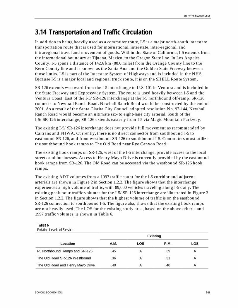
AFFECTED ENVIRONMENT
SCO/CH 3.DOC/010610003 3-18
3.14 Transportation and Traffic CirculationIn addition to being heavily used as a commuter route, I-5 is a major north-south interstatetransportation route that is used for international, interstate, inter-regional, andintraregional travel and movement of goods. Within the State of California, I-5 extends fromthe international boundary at Tijuana, Mexico, to the Oregon State line. In Los AngelesCounty, I-5 spans a distance of 142.6 km (88.6 miles) from the Orange County line to theKern County line and is known as the Santa Ana and the Golden State Freeway betweenthose limits. I-5 is part of the Interstate System of Highways and is included in the NHS.Because I-5 is a major local and regional truck route, it is on the SHELL Route System.
SR-126 extends westward from the I-5 interchange to U.S. 101 in Ventura and is included inthe State Freeway and Expressway System. The route is used heavily between I-5 and theVentura Coast. East of the I-5/SR-126 interchange at the I-5 northbound off-ramp, SR-126connects to Newhall Ranch Road. Newhall Ranch Road would be constructed by the end of2001. As a result of the Santa Clarita City Council adopted resolution No. 97-144, NewhallRanch Road would become an ultimate six- to eight-lane city arterial. South of theI-5/SR-126 interchange, SR-126 extends easterly from I-5 via Magic Mountain Parkway.
The existing I-5/SR-126 interchange does not provide full movement as recommended byCaltrans and FHWA. Currently, there is no direct connector from southbound I-5 toeastbound SR-126, and from westbound SR-126 to southbound I-5. Commuters must utilizethe southbound hook ramps to The Old Road near Rye Canyon Road.
The existing hook ramps on SR-126, west of the I-5 interchange, provide access to the localstreets and businesses. Access to Henry Mayo Drive is currently provided by the eastboundhook ramps from SR-126. The Old Road can be accessed via the westbound SR-126 hookramps.
The existing ADT volumes from a 1997 traffic count for the I-5 corridor and adjacentarterials are shown in Figure 2 in Section 1.2.2. The figure shows that the interchangeexperiences a high volume of traffic, with 89,000 vehicles traveling along I-5 daily. Theexisting peak-hour traffic volumes for the I-5/SR-126 interchange are illustrated in Figure 3in Section 1.2.2. The figure shows that the highest volume of traffic is on the eastboundSR-126 connection to southbound I-5. The figure also shows that the existing hook rampsare not heavily used. The LOS for the existing study area, based on the above criteria and1997 traffic volumes, is shown in Table 6.
TABLE 6Existing Levels of Service
Existing
Location A.M. LOS P.M. LOS
I-5 Northbound Ramps and SR-126 .45 A .39 A
The Old Road SR-126 Westbound .36 A .31 A
The Old Road and Henry Mayo Drive .40 A .40 A

AFFECTED ENVIRONMENT
SCO/CH 3.DOC/010610003 3-19
The above data show that, within the study area, the existing intersections operate at anLOS A during both the a.m. and p.m. peak hours.
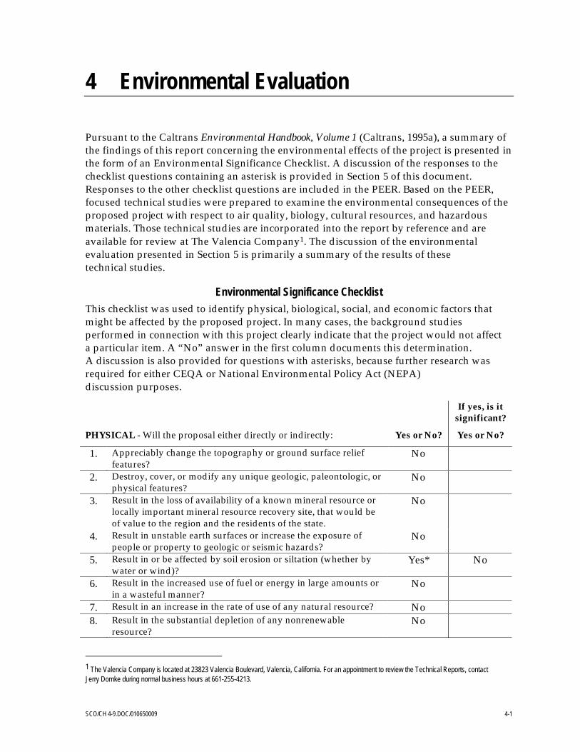
SCO/CH 4-9.DOC/010650009 4-1
4 Environmental Evaluation
Pursuant to the Caltrans Environmental Handbook, Volume 1 (Caltrans, 1995a), a summary ofthe findings of this report concerning the environmental effects of the project is presented inthe form of an Environmental Significance Checklist. A discussion of the responses to thechecklist questions containing an asterisk is provided in Section 5 of this document.Responses to the other checklist questions are included in the PEER. Based on the PEER,focused technical studies were prepared to examine the environmental consequences of theproposed project with respect to air quality, biology, cultural resources, and hazardousmaterials. Those technical studies are incorporated into the report by reference and areavailable for review at The Valencia Company1. The discussion of the environmentalevaluation presented in Section 5 is primarily a summary of the results of thesetechnical studies.
Environmental Significance ChecklistThis checklist was used to identify physical, biological, social, and economic factors thatmight be affected by the proposed project. In many cases, the background studiesperformed in connection with this project clearly indicate that the project would not affecta particular item. A “No” answer in the first column documents this determination.A discussion is also provided for questions with asterisks, because further research wasrequired for either CEQA or National Environmental Policy Act (NEPA)discussion purposes.
If yes, is itsignificant?
PHYSICAL - Will the proposal either directly or indirectly: Yes or No? Yes or No?
1. Appreciably change the topography or ground surface relieffeatures?
No
2. Destroy, cover, or modify any unique geologic, paleontologic, orphysical features?
No
3. Result in the loss of availability of a known mineral resource orlocally important mineral resource recovery site, that would beof value to the region and the residents of the state.
No
4. Result in unstable earth surfaces or increase the exposure ofpeople or property to geologic or seismic hazards?
No
5. Result in or be affected by soil erosion or siltation (whether bywater or wind)?
Yes* No
6. Result in the increased use of fuel or energy in large amounts orin a wasteful manner?
No
7. Result in an increase in the rate of use of any natural resource? No8. Result in the substantial depletion of any nonrenewable
resource?No
1 The Valencia Company is located at 23823 Valencia Boulevard, Valencia, California. For an appointment to review the Technical Reports, contactJerry Domke during normal business hours at 661-255-4213.
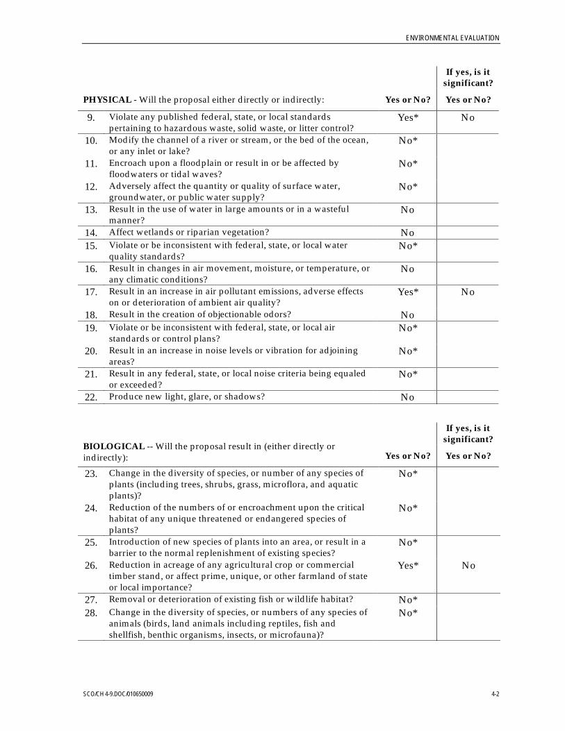
ENVIRONMENTAL EVALUATION
SCO/CH 4-9.DOC/010650009 4-2
If yes, is itsignificant?
PHYSICAL - Will the proposal either directly or indirectly: Yes or No? Yes or No?
9. Violate any published federal, state, or local standardspertaining to hazardous waste, solid waste, or litter control?
Yes* No
10. Modify the channel of a river or stream, or the bed of the ocean,or any inlet or lake?
No*
11. Encroach upon a floodplain or result in or be affected byfloodwaters or tidal waves?
No*
12. Adversely affect the quantity or quality of surface water,groundwater, or public water supply?
No*
13. Result in the use of water in large amounts or in a wastefulmanner?
No
14. Affect wetlands or riparian vegetation? No15. Violate or be inconsistent with federal, state, or local water
quality standards?No*
16. Result in changes in air movement, moisture, or temperature, orany climatic conditions?
No
17. Result in an increase in air pollutant emissions, adverse effectson or deterioration of ambient air quality?
Yes* No
18. Result in the creation of objectionable odors? No19. Violate or be inconsistent with federal, state, or local air
standards or control plans?No*
20. Result in an increase in noise levels or vibration for adjoiningareas?
No*
21. Result in any federal, state, or local noise criteria being equaledor exceeded?
No*
22. Produce new light, glare, or shadows? No
If yes, is itsignificant?
BIOLOGICAL -- Will the proposal result in (either directly orindirectly): Yes or No? Yes or No?
23. Change in the diversity of species, or number of any species ofplants (including trees, shrubs, grass, microflora, and aquaticplants)?
No*
24. Reduction of the numbers of or encroachment upon the criticalhabitat of any unique threatened or endangered species ofplants?
No*
25. Introduction of new species of plants into an area, or result in abarrier to the normal replenishment of existing species?
No*
26. Reduction in acreage of any agricultural crop or commercialtimber stand, or affect prime, unique, or other farmland of stateor local importance?
Yes* No
27. Removal or deterioration of existing fish or wildlife habitat? No*28. Change in the diversity of species, or numbers of any species of
animals (birds, land animals including reptiles, fish andshellfish, benthic organisms, insects, or microfauna)?
No*
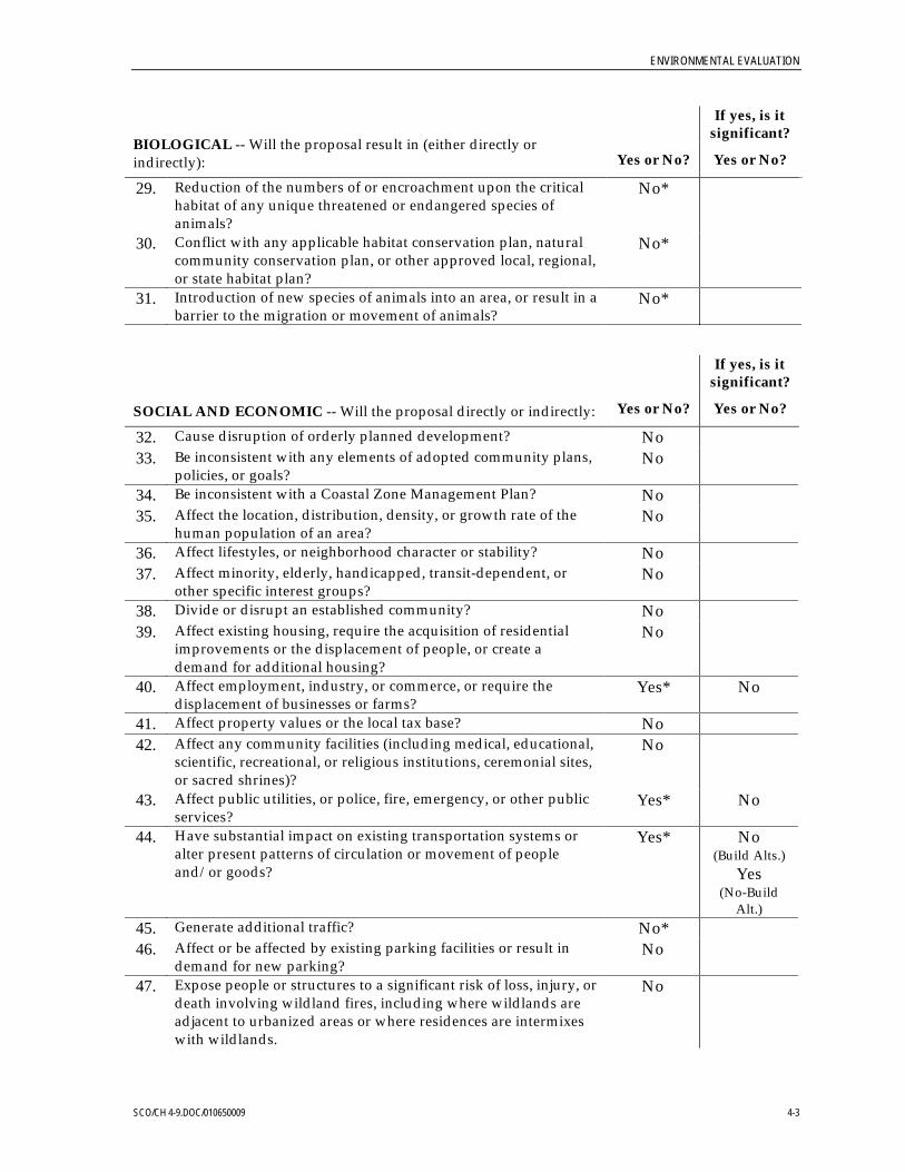
ENVIRONMENTAL EVALUATION
SCO/CH 4-9.DOC/010650009 4-3
If yes, is itsignificant?
BIOLOGICAL -- Will the proposal result in (either directly orindirectly): Yes or No? Yes or No?
29. Reduction of the numbers of or encroachment upon the criticalhabitat of any unique threatened or endangered species ofanimals?
No*
30. Conflict with any applicable habitat conservation plan, naturalcommunity conservation plan, or other approved local, regional,or state habitat plan?
No*
31. Introduction of new species of animals into an area, or result in abarrier to the migration or movement of animals?
No*
If yes, is itsignificant?
SOCIAL AND ECONOMIC -- Will the proposal directly or indirectly: Yes or No? Yes or No?
32. Cause disruption of orderly planned development? No33. Be inconsistent with any elements of adopted community plans,
policies, or goals?No
34. Be inconsistent with a Coastal Zone Management Plan? No35. Affect the location, distribution, density, or growth rate of the
human population of an area?No
36. Affect lifestyles, or neighborhood character or stability? No37. Affect minority, elderly, handicapped, transit-dependent, or
other specific interest groups?No
38. Divide or disrupt an established community? No39. Affect existing housing, require the acquisition of residential
improvements or the displacement of people, or create ademand for additional housing?
No
40. Affect employment, industry, or commerce, or require thedisplacement of businesses or farms?
Yes* No
41. Affect property values or the local tax base? No42. Affect any community facilities (including medical, educational,
scientific, recreational, or religious institutions, ceremonial sites,or sacred shrines)?
No
43. Affect public utilities, or police, fire, emergency, or other publicservices?
Yes* No
44. Have substantial impact on existing transportation systems oralter present patterns of circulation or movement of peopleand/or goods?
Yes* No(Build Alts.)
Yes(No-Build
Alt.)45. Generate additional traffic? No*46. Affect or be affected by existing parking facilities or result in
demand for new parking?No
47. Expose people or structures to a significant risk of loss, injury, ordeath involving wildland fires, including where wildlands areadjacent to urbanized areas or where residences are intermixeswith wildlands.
No

ENVIRONMENTAL EVALUATION
SCO/CH 4-9.DOC/010650009 4-4
If yes, is itsignificant?
SOCIAL AND ECONOMIC -- Will the proposal directly or indirectly: Yes or No? Yes or No?
48. Involve a substantial risk of an explosion or the release ofhazardous substances in the event of an accident or otherwiseadversely affect overall public safety?
No*
49. Result in alterations to waterborne, rail, or air traffic? No50. Support large commercial or residential development? Yes* No51. Affect a substantial archaeological or historic site, structure,
object, or building?No*
52. Affect wild or scenic rivers, or natural landmarks? No53. Affect any scenic resources or result in the obstruction of any
scenic vista or view open to the public, or creation of anaesthetically offensive site open to public view?
No*
54. Result in substantial impacts associated with constructionactivities (e.g., noise, dust, temporary drainage, traffic detoursand temporary access, etc.)?
No
55. Result in the use of any publicly-owned land from a park,recreation area, or wildlife and waterfowl refuge?
No
MANDATORY FINDINGS OF SIGNIFICANCE Yes or No?
56. Does the project have the potential to substantially degrade the quality of theenvironment, substantially reduce the habitat of a fish or wildlife species,cause a fish or wildlife population to drop below self-sustaining levels,threaten to eliminate a plant or animal community, reduce the number orrestrict the range of a rare or endangered plant or animal, or eliminateimportant examples of the major periods of California history or prehistory?
No
57. Does the project have the potential to achieve short-term, to the disadvantageof long-term, environmental goals? (A short- term impact on the environmentis one that occurs in a relatively brief, definitive period of time while long-termimpacts will endure well into the future.)
No
58. Does the project have environmental effects that are individually limited, butcumulatively considerable? Cumulatively considerable means that theincremental effects of an individual project are considerable when viewed inconnection with the effects of past projects, the effects of other current projects,and the effects of probable future projects. It includes the effects of otherprojects that interact with this project and, together, are considerable.
No*
59. Does the project have environmental effects that will cause substantial adverseeffects on human beings, either directly or indirectly?
No
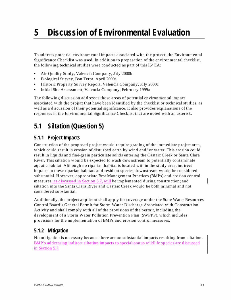
SCO/CH 4-9.DOC/010650009 5-1
5 Discussion of Environmental Evaluation
To address potential environmental impacts associated with the project, the EnvironmentalSignificance Checklist was used. In addition to preparation of the environmental checklist,the following technical studies were conducted as part of this IS/EA:
• Air Quality Study, Valencia Company, July 2000b• Biological Survey, Bon Terra, April 2000a• Historic Property Survey Report, Valencia Company, July 2000c• Initial Site Assessment, Valencia Company, February 1999a
The following discussion addresses those areas of potential environmental impactassociated with the project that have been identified by the checklist or technical studies, aswell as a discussion of their potential significance. It also provides explanations of theresponses in the Environmental Significance Checklist that are noted with an asterisk.
5.1 Siltation (Question 5)5.1.1 Project ImpactsConstruction of the proposed project would require grading of the immediate project area,which could result in erosion of disturbed earth by wind and/or water. This erosion couldresult in liquids and fine-grain particulate solids entering the Castaic Creek or Santa ClaraRiver. This siltation would be expected to wash downstream to potentially contaminateaquatic habitat. Although no riparian habitat is located within the study area, indirectimpacts to these riparian habitats and resident species downstream would be consideredsubstantial. However, appropriate Best Management Practices (BMPs) and erosion controlmeasures, as discussed in Section 5.7, will be implemented during construction; andsiltation into the Santa Clara River and Castaic Creek would be both minimal and notconsidered substantial.
Additionally, the project applicant shall apply for coverage under the State Water ResourcesControl Board’s General Permit for Storm Water Discharge Associated with ConstructionActivity and shall comply with all of the provisions of the permit, including thedevelopment of a Storm Water Pollution Prevention Plan (SWPPP), which includesprovisions for the implementation of BMPs and erosion control measures.
5.1.2 MitigationNo mitigation is necessary because there are no substantial impacts resulting from siltation.BMP’s addressing indirect siltation impacts to special-status wildlife species are discussedin Section 5.7.

DISCUSSION OF ENVIRONMENTAL EVALUATION
SCO/CH 4-9.DOC/010650009 5-2
5.2 Hazardous Waste (Questions 9 and 48)5.2.1 Project ImpactsAs discussed in Section 3.11, an ISA was conducted for the proposed project (ValenciaCompany, 1999a). This report concluded that the following recognized environmentalconditions were identified at the subject parcel:
• Potential groundwater contamination from past agricultural land use at the site andleaking USTs and a landfill at nearby properties
• Potential for residual concentration of pesticides/herbicides in soil resulting fromroutine applications associated with past agricultural land use at the subject parcel
Approximately 0.5 hectare (1.3 acres) of potentially contaminated land would be requiredfor the Build Alternative, with no additional right-of-way required for the No-BuildAlternative. Because no recognized environmental concerns were observed during aMay 1998 site visit, these potential environmental conditions are not considered adverseimpacts. As a result, the proposed project is not expected to result in a risk of the release ofhazardous substances during the construction and operation of the proposed project andwould not endanger the safety of workers or the general public. Additionally, neither thepresence of these conditions nor the construction or operation of the proposed project areanticipated to violate any published federal, state, or local standards pertaining tohazardous waste, solid waste, or litter control.
Recent aerially deposited lead testing determined that lead levels in the soil are notsignificant. As a result, any soil removed during construction would be able to be used asfill for other areas of the project and would not require landfilling or placement at ahazardous materials site. These tests were completed prior to the purchase or exchange ofright-of-way to the State of California, who is prohibited from purchasing or receiving landon which contaminants are located.
Construction of the proposed project would result in the generation of concrete and asphaltdebris and rebar; however, the majority of these materials would be reused in theconstruction of the proposed project and would not result in a significant project impact.Food wrappers, miscellaneous trash, and septic waste from the construction contractoremployees would be generated during the construction phase of the project. Chemicaltoilets would be used for septic waste; however, the project would generate solid wasteonly during the short-term construction period, so only minimal impacts would beexpected. In the long term, no solid waste would be generated by any of the alternatives forthe I-5/SR-126 Interchange Project. As a result, the project would result in less-than-substantial impacts to solid waste management.
The proposed project would require the removal of existing traffic stripes and pavementmarkings using either yellow thermoplastic strips or paint. These materials have thepotential to contain hazardous levels of lead and/or chromium which would be dangerousto both the environment and human health. These materials are typically removed usingsand or air blasting equipment. Workers are required to adhere to OSHA standards, whichincludes wearing protective clothing. After blasting, the blasted material is collected and

DISCUSSION OF ENVIRONMENTAL EVALUATION
SCO/CH 4-9.DOC/010650009 5-3
disposed of at an appropriate hazardous materials facility.Recent aerially deposited leadtesting determined that lead levels in the soil are not significant. As a result, any soilremoved during construction would be able to be used as fill for other areas of the projectand would not require landfilling or placement at a hazardous materials site. These testswere completed prior to the purchase or exchange of right-of-way to the State of California,who is prohibited from purchasing or receiving land on which contaminants are located.
Construction of the proposed project would result in the generation of concrete and asphaltdebris and rebar; however, the majority of these materials would be reused in theconstruction of the proposed project and would not result in a significant project impact.Food wrappers, miscellaneous trash, and septic waste from the construction contractoremployees would be generated during the construction phase of the project. Chemicaltoilets would be used for septic waste; however, the project would generate solid wasteonly during the short-term construction period, so only minimal impacts would beexpected. In the long term, no solid waste would be generated by any of the alternatives forthe I-5/SR-126 Interchange Project. As a result, the project would result in less-than-substantial impacts to solid waste management.
The proposed project would require the removal of existing traffic stripes and pavementmarkings using either yellow thermoplastic strips or paint. These materials have thepotential to contain hazardous levels of lead and/or chromium which would be dangerousto both the environment and human health. These materials are typically removed usingsand or air blasting equipment. Workers are required to adhere to OSHA standards, whichincludes wearing protective clothing. After blasting, the blasted material is collected anddisposed of at an appropriate hazardous materials facility.
5.2.2 MitigationAlthough no substantial potential for or evidence of hazardous material contamination wasobserved or detected while conducting the ISA, the following mitigation measures arerecommended to further minimize this potential during construction activities:
• During construction, waste material would be classified and recycled or reused, asappropriate.
• If a previously undetected hazardous waste site/location is unearthed duringconstruction, all excavation activities in the immediate vicinity of the contaminated sitewould be suspended. Caltrans, in conjunction with other appropriate agencies, woulddevelop a plan to investigate the site of contamination and to determine what correctivemeasures, if any, may be required to safeguard public health and the environment.Waste material removed from the construction area would be disposed of in accordancewith current standards specified in Title 22 of the California Code of Regulations (22CCR).
• There is the potential for minor groundwater and soil contamination due to nearbyleaking USTs, a solid waste landfill, and past agricultural activities. It is believed thatthe proposed project would not require excavation that would impact the groundwaterlevel. A Site Investigation (SI) to verify the presence and extent of the hazardous wastewithin the project area would be conducted during the design stage, after roadway

DISCUSSION OF ENVIRONMENTAL EVALUATION
SCO/CH 4-9.DOC/010650009 5-4
geometric plans have been approved, so that design and right-of-way issues can beidentified and resolved at an early stage. If contamination is identified, the districtwould consider alternatives (including design variations) to avoid the hazardous wastearea. If the site cannot be avoided, remediation of the contaminated site should beconsidered prior to construction because the State of California cannot purchase or begiven property containing contaminated materials.
5.3 Water Resources (Questions 10, 12, and 15)5.3.1 Project ImpactsThis section assesses impacts that the proposed project would have on nearby waterresources, including impacts from stormwater runoff and erosion during construction. Adiscussion of indirect water quality impacts to aquatic species can be found in Section 5.7.
Stormwater Runoff. There would be a slight increase in the amount of stormwater runoff onthe project site due to an increased amount of impervious surfaces. As a result, there wouldbe a small increase in runoff to the Santa Clara River, which could potentially degradesurface water quality. However, adherence to standard construction methods and BMPswould minimize adverse environmental effects to the Santa Clara River, would prevent theproposed project from substantially affecting water quality, would ensure projectconsistency with state and federal water quality standards, and would ensure that waterquality impacts to aquatic species are avoided..
The total monthly runoff to the river was estimated as the net new impervious surface areaof the interchange (2.3 hectares [3.0 acres] for Alternative C) multiplied by the monthlyprecipitation totals at the National Weather Service station at Newhall (NWS, 1999). Thosemonthly totals were compared to the average monthly total hydraulic load of the river(using the data shown in Figure 2). For all months except November, the averageprecipitation was less than 1 percent of the river flow. In November, project-associatedstormwater runoff may average up to 2 percent of the river flow. In reality, stormwaterBMPs designed to absorb and infiltrate stormwater runoff would mitigate for almost allstormwater runoff from the site. No adverse impacts to the Santa Clara River are expectedfrom this small amount of project-associated runoff.
These BMPs would be described in detail as part of the SWPPP filed as part of theStormwater National Pollutant Discharge Elimination System (NPDES) permitting forthe project.
Erosion During Construction. Standard construction practices and adherence to the projectSWPPP filed as part of the Construction NPDES permit would protect the Santa Clara Riverand prevent substantial impacts related to erosion during construction. Constructionmanagement BMPs are designed to minimize erosion and stop downstream siltation duringconstruction activities. Standard BMPs (e.g., Caltrans, 1992) would include, but are notlimited to:
• The establishment of equipment staging areas and the isolation of hazardous materialsfrom drainage to the streambed

DISCUSSION OF ENVIRONMENTAL EVALUATION
SCO/CH 4-9.DOC/010650009 5-5
• The control of construction vehicles and containment of any leakage; a ban onequipment maintenance within the streambed
• The prohibition of all construction debris within the river channel
• Sediment traps and/or straw bale filters and silt fences
• Temporary and permanent revegetation of exposed soil with native plant material
Implementation of BMPs would minimize erosion during construction and would preventthe proposed project from substantially affecting water quality, and would ensure thatwater quality impacts to aquatic species are avoided.
5.3.2 MitigationSince there are no adverse impacts to water quality resulting from the proposed project, nomitigation measures are necessary. All potential impacts to water quality and floodingwould be minimized or prevented during construction by the implementation of andadherence to BMPs. BMP’s addressing indirect water quality impacts to special-statuswildlife species are discussed in Section 5.7.
The project would require both Construction and Operations Stormwater NPDES permits,as well as consultation with state and federal agencies concerning protection measures forthe listed aquatic species in the project vicinity.
5.4 Floodplain (Question 11)5.4.1 Project ImpactsAs discussed in the Floodplain Evaluation Report (Valencia Company, 2000a) and shown inFigure 10, the proposed project is not located within either the base 100-year floodplain orCapitol Floodplain for either the Santa Clara River or Castaic Creek. Additionally, there areno impacts to natural and beneficial floodplain values; and the proposed project would notsupport incompatible floodplain development. The proposed project is consistent withexisting watershed and floodplain management programs.
5.4.2 MitigationNo mitigation is necessary because there are no impacts to the Santa Clara River orCastaic Creek floodplains.
5.5 Air Quality (Questions 17 and 19)5.5.1 Project ImpactsConstruction Impacts. Emissions from the proposed project would impact air quality duringconstruction. Equipment would be used during site preparation and project construction foractivities such as clearing, grading, excavating, loading/unloading of trucks, and travel onunpaved roads. These activities would generate emissions of fugitive dust and impact localair quality.

DISCUSSION OF ENVIRONMENTAL EVALUATION
SCO/CH 4-9.DOC/010650009 5-6
In addition to the fugitive dust, the exhaust emissions from the operation of heavyequipment would also contain criteria pollutants such as PM10, NOX, and ROC. NOX andROC are important because they react to form ozone in the presence of sunlight. Thevehicles of commuting workers and other equipment powered by internal combustionengines would also generate emissions of criteria pollutants and could impact air quality ator near the construction site. Impacts due to equipment emissions and fugitive dust wouldbe considered substantial without the implementation of BMPs, discussed below.
Operational Impacts. A transportation project can affect regional air quality if emissions ofozone precursors (NOX and ROC) from traffic are greater with the project than without theproject. In order to be found in conformance with the Federal Clean Air Act Amendments(CAAAs) of 1990, a project must come from approved transportation plans and programssuch as the RTP and the RTIP. The CAAAs of 1990 require that transportation plans,programs, and projects that are funded by or approved under Title 23 United States Code(U.S.C.) or Federal Transit Act (FTA) conform to state or federal air quality plans. Theproposed project is identified in the 2000/01 – 2005/06 RTIP, which was approved by theU.S. Department of Transportation (DOT) (FHWA/FTA) on October 6, 2000. Interchangeimprovements/reconfigurations projects of this type are identified in the EPA ConformityRule category of exempt projects that are exempt from the requirement that a regionalemissions analysis be made.
The pollutant of primary concern when assessing localized impacts of transportationprojects is CO. High CO concentrations tend to accumulate near areas of heavy trafficcongestion where average vehicle speeds are low. Localized impacts are assessed byestimating maximum ambient CO concentrations near the roadways affected by the project.The concentrations are compared to the national and California ambient air qualitystandards for CO. The impact of a project is considered to be adverse if the project creates anew CO violation or exacerbates an existing violation.
In general, the proposed project would improve traffic flow and increase average vehiclespeeds through the interchange relative to the no-project condition; therefore, the project isgenerally expected to have a beneficial impact on localized air quality. However, thelocation of the proposed intersection at the southbound I-5 off-ramp with SR-126(Alternative C) would potentially move traffic closer to a receptor site. For this reason, a COscreening analysis was performed to determine if this intersection would cause localizedviolations of the standards for CO. Localized CO impacts were evaluated using theTransportation Project-Level Carbon Monoxide Protocol written by the Institute of TrafficStudies at the University of California, Davis, 1997. In order to use the screening procedure,the following assumptions were made: the project would have less than 50 percent vehiclesin cold start mode, the percentage of heavy-duty gas trucks would be less than 1.2 percent,traffic volumes would be less than 1,000 vehicles per hour per lane, and the January meanminimum temperature would be greater than 35 degrees Fahrenheit (° F). SCAG endorsesthe use of the protocol to assess project-level impacts.
Table 7 presents the peak 1-hour and 8-hour CO concentrations predicted near the modeledintersection under build-out conditions (2020) (refer to the separate Air Quality AnalysisReport for a more detailed analysis). The analysis shows that the maximum 1-hour COconcentration would be 14.8 ppm, which is well below the national standard of 35 ppm and
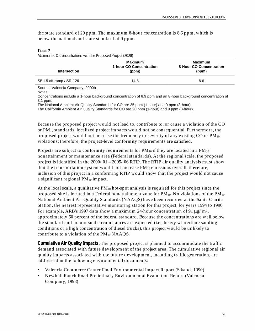
DISCUSSION OF ENVIRONMENTAL EVALUATION
SCO/CH 4-9.DOC/010650009 5-7
the state standard of 20 ppm. The maximum 8-hour concentration is 8.6 ppm, which isbelow the national and state standard of 9 ppm.
TABLE 7Maximum CO Concentrations with the Proposed Project (2020)
Intersection
Maximum1-hour CO Concentration
(ppm)
Maximum8-Hour CO Concentration
(ppm)
SB I-5 off-ramp / SR-126 14.8 8.6
Source: Valencia Company, 2000b.Notes:Concentrations include a 1-hour background concentration of 6.9 ppm and an 8-hour background concentration of3.1 ppm.The National Ambient Air Quality Standards for CO are 35 ppm (1-hour) and 9 ppm (8-hour).The California Ambient Air Quality Standards for CO are 20 ppm (1-hour) and 9 ppm (8-hour).
Because the proposed project would not lead to, contribute to, or cause a violation of the COor PM10 standards, localized project impacts would not be consequential. Furthermore, theproposed project would not increase the frequency or severity of any existing CO or PM10
violations; therefore, the project-level conformity requirements are satisfied.
Projects are subject to conformity requirements for PM10 if they are located in a PM10
nonattainment or maintenance area (Federal standards). At the regional scale, the proposedproject is identified in the 2000/01 – 2005/06 RTIP. The RTIP air quality analysis must showthat the transportation system would not increase PM10 emissions overall; therefore,inclusion of this project in a conforming RTIP would show that the project would not causea significant regional PM10 impact.
At the local scale, a qualitative PM10 hot-spot analysis is required for this project since theproposed site is located in a Federal nonattainment zone for PM10. No violations of the PM10
National Ambient Air Quality Standards (NAAQS) have been recorded at the Santa ClaritaStation, the nearest representative monitoring station for this project, for years 1994 to 1996.For example, ARB’s 1997 data show a maximum 24-hour concentration of 91 µg/m3,approximately 60 percent of the federal standard. Because the concentrations are well belowthe standard and no unusual circumstances are expected (i.e., heavy wintertime sandingconditions or a high concentration of diesel trucks), this project would be unlikely tocontribute to a violation of the PM10 NAAQS.
Cumulative Air Quality Impacts. The proposed project is planned to accommodate the trafficdemand associated with future development of the project area. The cumulative regional airquality impacts associated with the future development, including traffic generation, areaddressed in the following environmental documents:
• Valencia Commerce Center Final Environmental Impact Report (Sikand, 1990)• Newhall Ranch Road Preliminary Environmental Evaluation Report (Valencia
Company, 1998)

DISCUSSION OF ENVIRONMENTAL EVALUATION
SCO/CH 4-9.DOC/010650009 5-8
The proposed I-5/SR-126 improvement project would not generate any additional traffic;therefore, the contribution of the project to cumulative regional air quality impacts wouldnot be consequential.
The screening analysis for localized CO impacts included traffic volumes projected byAustin-Foust Associates for the year 2020. These traffic projections were derived from theSanta Clarita Valley Consolidated Traffic Model using future land use and travel patternsthat account for the cumulative projected growth of the project area. As stated above,localized impacts would be less than the ambient air quality standards; therefore, it isconcluded that localized cumulative impacts would not be consequential.
5.5.2 Mitigation
Construction Mitigation. Impacts due to the generation of fugitive dust and presence of othercriteria pollutants would be less than substantial; however, the following measures aregenerally accepted construction management practices used to mitigate the air qualityimpacts of a project.
1. Fugitive Dust Control
a. Apply EPA-approved nontoxic chemical soil stabilizers to all inactiveconstruction areas (i.e., previously graded areas inactive for 5 days or more)
b. Water active grading and parking areas at least twice daily during dryseason (May 1 through November 1)
c. Enclose, cover, water twice daily, or apply approved soil binders toexposed stockpiles
d. Suspend all excavation and grading operations when instantaneous windspeeds reach 40.2 km per hour (25 miles per hour)
e. Cover or maintain at least 0.6 m (2 feet) of freeboard on all trucks haulingdirt, sand, silt, or other loose materials
f. Sweep paved streets at the end of the day if visible soil material is carriedover to adjacent paved roads
g. Install wheel washers where vehicles enter and exit unpaved roads ontopaved roads, or wash off mud from trucks leaving the site
2. Vehicular Emissions Controls
a. Maintain equipment and vehicle engines in good condition and in propertune as per manufacturer’s specifications and per SCAQMD rules
b. Use electricity from existing nearby power lines rather than from temporarydiesel- or gasoline-powered generators, to the extent feasible
c. Provide temporary traffic control during all phases of construction activitiesthat affect circulation on public roads to maintain traffic flow

DISCUSSION OF ENVIRONMENTAL EVALUATION
SCO/CH 4-9.DOC/010650009 5-9
d. Schedule construction activities that affect traffic flow on the arterial systemto off-peak hours
Operational Mitigation. Because the proposed project would not contribute to a violation ofthe CO standards and would have inconsequential, localized project effects, and becausethe project-level conformity requirements are satisfied, no mitigation for operationalimpacts is necessary.
Cumulative Mitigation. The contribution of the project to cumulative regional air qualityimpacts would be inconsequential. As a result, no mitigation measures for cumulative airquality impacts are necessary.
5.6 Noise (Questions 20 and 21)5.6.1 Project ImpactsAs discussed in Section 3.13, a screening procedure for noise impacts indicated that thereare no existing or planned noise-sensitive receivers located within the vicinity of theproposed project. As a result, no noise impacts would result from the proposed interchangeimprovements. A discussion of potential indirect noise impacts to special-status species canbe found in Section 5.7.
5.6.2 MitigationNo mitigation is necessary because there are no substantial noise impacts. BMP’saddressing indirect noise impacts to special-status wildlife species are discussed in Section5.7.
5.7 Biological Resources (Questions 23 to 25 and 27 to 31)5.7.1 Project ImpactsImpacts Documented in Original Biological Survey Report and Subsequent Focused Surveys.
The existing mixed sage scrub east of I-5 within the project right-of-way was to be removedwhen the City of Santa Clarita graded Newhall Ranch Road from Stanford Avenue east toVanderbilt Way. Because this construction occurred prior to the construction of theproposed project, no impacts to the slender mariposa lily and Plummer’s mariposa lily areanticipated as a result of implementation of this proposed project. An EnvironmentallySensitive Area would be employed to ensure that construction activities do not occuroutside of project limits.
A focused survey was conducted to determine the presence or absence of special-statusplant species within the I-5/SR-126 interchange study area (Bon Terra, 2000b). Field surveyslocated a single individual of the club-haired mariposa lily within the study area. However,as mentioned above, the site was graded as part of the construction for the Newhall RanchRoad extension; and the plant was removed. No other special-status species were observedduring the focused survey. The focused survey recommended that because the only club-
DISCUSSION OF ENVIRONMENTAL EVALUATION
SCO/CH 4-9.DOC/010650009 5-10
haired mariposa lily plant observed was removed, the proposed project, therefore, wouldnot impact this species; and no mitigation would be warranted. However, EnvironmentallySensitive Areas would be employed to ensure that construction activities do not occuroutside the project limits.A focused survey was conducted to determine the presence orabsence of special-status plant species within the I-5/SR-126 interchange study area (BonTerra, 2000b). Field surveys located a single individual of the club-haired mariposa lilywithin the study area. However, as mentioned above, the site was graded as part of theconstruction for the Newhall Ranch Road extension; and the plant was removed. No otherspecial-status species were observed during the focused survey. The focused surveyrecommended that because the only club-haired mariposa lily plant observed was removed,the proposed project, therefore, would not impact this species; and no mitigation would bewarranted. However, Environmentally Sensitive Areas would be employed to ensure thatconstruction activities do not occur outside the project limits.
No special-status wildlife species are anticipated within the project area, and no raptor nestswere identified during the September 1999 site survey. Consequently, no project impactsare anticipated, including impacts to the unarmored threespine stickleback (Gasterosteusaculeatus williamsoni), least Bell’s vireo (Vireo bellii pusillus), or southwestern willowflycatcher (Empidonax traillii extimusincluding impacts to the unarmored threespinestickleback (Gasterosteus aculeatus williamsoni), least Bell’s vireo (Vireo bellii pusillus), orsouthwestern willow flycatcher (Empidonax traillii extimus). However, it is important to notethat the loss of any active nest on the site, including nests of both raptors and othermigratory non-game birds, would be considered a substantial project impact. To avoidthese potential impacts and to comply with the Federal Migratory Bird Treaty Act of 1918(50 CFR Section 10.13) and Sections 3503, 3503.3, and 3513 of the California Fish and GameCodeand to comply with the Federal Migratory Bird Treaty Act of 1918 (50 CFRSection 10.13) and Sections 3503, 3503.3, and 3513 of the California Fish and Game Code, aqualified biologist would be required to survey within the limits of project disturbance forthe presence of occupied nests 30 days prior to the onset of construction activities, shouldpotential habitat be affected outside the breeding season (i.e., March 1 to August 31).During the breeding season, a biological monitor should survey for active bird nests nosooner than 2 days prior to project-related disturbances to breeding bird habitat on andadjacent to the proposed project siteshould potential habitat be affected outside thebreeding season (i.e., March 1 to August 31). During the breeding season, a biologicalmonitor should survey for active bird nests no sooner than 2 days prior to project-relateddisturbances to breeding bird habitat on and adjacent to the proposed project site. Anyoccupied nests found during the survey would be protected until nesting activity hasended to ensure compliance with Section 3503.5 of the California Fish and Game Code.Additionally, a minimum buffer would be provided, as determined by the biologicalmonitor. Nesting activity for raptors in the region of the study area normally occurs fromFebruary Additionally, a minimum buffer would be provided, as determined by thebiological monitor. Nesting activity for raptors in the region of the study area normallyoccurs from February 1 to June 30.
Impacts Documented in Response to U.S. Fish and Wildlife Service Comments.
In response to U.S. Fish and Wildlife Service concerns (Appendix E, Comment Letter 13)regarding water quality and noise impacts to special-status species known or potentially
DISCUSSION OF ENVIRONMENTAL EVALUATION
SCO/CH 4-9.DOC/010650009 5-11
occurring within the Santa Clara River in the vicinity of the project site, a White Paper(BonTerra, 2001) was prepared to address these concerns. The paper (1) summarized theexisting biological conditions on the project site; (2) ascertained the potential forspecial-status species that could be negatively affected by runoff or noise impacts; and(3) identified project mitigation measures that will be implemented to ensure that no director indirect impacts occur to listed species as a result of project implementation. The WhitePaper is attached as Appendix A, and major findings from the paper are summarizedbelow.
There would be no direct or indirect impacts to special-status plant species. The onlyknown special-status plant species to occur in the region are Nevin’s barberry (Berberisnevinii) and slender-horned spineflower (Dodecahema leptoceras). These species were notobserved within the study area during focused surveys conducted within the study area inthe spring of 2000. Therefore, these species would not be impacted by the proposed project.
The proposed project would not directly impact special-status aquatic species in the SantaClara River, such as the unarmored threespine stickleback, the southern Californiasteelhead, and the arroyo southwestern toad. The proposed project is located outside theSanta Clara River and construction limits are over 194 meters (635 feet) from the Santa ClaraRiver at its closest point. In addition, the impact area of the proposed project does notrepresent suitable upland estivating habitat for the arroyo toad because of the urban natureof the impact area (i.e., existing freeway interchange) and the highly disturbed areas (i.e.,active agricultural fields, roadway, and various commercial and industrial buildings andassociated facilities) that exist between the proposed project and the Santa Clara River.Therefore, there would be no direct impact to these species’ habitats.
Due to a slight increase in stormwater runoff and construction related activities generatedby the proposed project, the water quality of the Santa Clara River may be affected, therebyindirectly impacting aquatic species. However, to ensure that water quality impacts toaquatic species are avoided, the following avoidance measures, approved by the USFWS forother projects with similar environmental baseline settings, shall be used:
• Erosion control measures incorporated into the final grading plans consistent withCaltrans’ specifications shall include the following design features:− Placement of silt fencing, weed-free hay bales or straw wattles, sandbags, sediment
catchment devices, or other methods designed to reduce velocities and erosion.These erosion control features will be placed at each inlet, along each toe of slope, oras appropriate in accordance with the plan.
− Hydro seed exposed or bare areas with native plant species.• Excavated materials shall be stockpiled with erosion protection to ensure that these
materials do not enter the Santa Clara River.• Maintenance and fueling of large construction equipment and machinery shall occur in
areas that are designed to prevent spillages of fuels, lubricants, cleaners and otherfluids.
• The project will include an infiltration basin to catch sediment and storm water runoffwithin the northwestern portion of the project. This BMP is intended to absorb andinfiltrate stormwater runoff.

DISCUSSION OF ENVIRONMENTAL EVALUATION
SCO/CH 4-9.DOC/010650009 5-12
With the implementation of the above avoidance measures, there will be no indirectimpacts to aquatic species.
Special-status bird species such as the southwestern willow flycatcher and least Bell’s vireohave low and moderate potential for occurring in the project area. However, because theproposed project is located outside the Santa Clara River and no riparian vegetation will beremoved as a result of the project, no direct impacts to these species are expected to occur.
As discussed in Section 5.6, no existing or planned noise-sensitive receivers are locatedwithin the vicinity of the proposed project. However, based on comments from the USFWSregarding the potential indirect noise impacts on listed wildlife species that are known orpotentially occur within the Santa Clara River, an assessment of the highest noise levels thatwould be generated by the construction of the interchange improvements was conducted.This assessment was based on the methods presented in the U.S. Department ofTransportation’s (DOT’s), Highway Construction Noise Measurement Prediction andMitigation guidelines. A figure, included as Figure 2 of Appendix A, was also prepared tographically portray the predicted noise environment resulting from the use of pile driversfor the construction of the Old Road bridge. The analysis indicates that the 60 dBA noisecontour would extend approximately 168 meters (550 feet) into the Santa Clara River overareas containing riparian habitat In consideration of the fact that the 60 dBA noiseenvironment is shown to extend within the river, the following avoidance measure shall beimplemented for the construction of the bridge facilities:
• No pile driving activities for I-5/SR-126 intersection and The Old Road/SR-126intersection construction shall occur during the least Bell’s vireo/southwestern willowflycatcher breeding season (April 1st and August 15th).
With the implementation of the above BMPs and avoidance measure, no indirect noiseimpacts to special-status species are expected to occur as a result of project implementation.
5.7.2 MitigationAs discussed above, implementation of BMPs and avoidance measures would preventindirect water quality and noise impacts to special-status species. In addition, Section 5.3(Water Resources) discusses the implementation of BMPs that would include the temporaryand permanent revegetation of exposed soil with native plant material to minimize soilerosion during construction that would also reduce the introduction of non-native plantspecies on the project site and adjacent areas. Establishment of Environmentally SensitiveAreas to avoid sensitive species and habitat outside the proposed project would ensure theprotection of plants immediately outside the construction area by installing orange plasticsnow fencing at the grading limits in the area where the plants were located. Pre-construction surveys for the San Diego black-trailed jackrabbit nest sites will also beperformed to ensure that this Species of Special Concern is not impacted. If these surveyslocate active nests or dens, construction activities will be scheduled to avoid disturbanceuntil the young in the nests are fully independent. With the implementation of BMPs andavoidance measures, there will be no impacts to special-status species.
Additional mitigation would not be required unless construction activities occurred outsidethe project limits. If so, focused surveys would need to be conducted to determine the

DISCUSSION OF ENVIRONMENTAL EVALUATION
SCO/CH 4-9.DOC/010650009 5-13
presence or absence of the slender mariposa lily and Plummer’s mariposa lily. If thesespecies were not found, no mitigation would be required.
5.8 Agriculture (Question 26)5.8.1 Project ImpactsCongress enacted the FPPA in 1981. It is intended to minimize the extent to which federalactivities contribute to the conversion of agricultural land to nonagricultural uses. It alsoseeks to ensure that federal policies are administered in a manner that would be compatiblewith state, local, and private policies that protect farmland. The FPPA requires federalagencies to examine the impact of their programs before they approve any activity thatwould convert farmland.
To rate the relative impact of projects on sites subject to the FPPA, federal agencies fill out aFarmland Conversion Impact Rating Form (Form AD-1006). The rating form is based on aLand Evaluation and Site Assessment (LESA) system, which is a numerical system thatmeasures the quality of farmland. LESA systems have two components. The LandEvaluation element rates soil quality. The Site Assessment component measures otherfactors that affect the farm's viability including, but not limited to, proximity to water andsewer lines and the size of the parcel.
Sites receiving a combined score of less than 160 do not require further evaluation.Alternatives should be proposed for sites with a combined score greater than 160 points. Onthe basis of this analysis, a federal agency may, but is not required to, deny assistance toprivate parties and state and local governments undertaking projects that wouldconvert farmland.
Active farmland is present west of I-5 between SR-126 and Henry Mayo Drive, and west ofThe Old Road within the area created by the SR-126 hook ramps. The property has beenzoned by Los Angeles County as Urban 4 (with 15.0 to 40.0 dwelling units per acre).Construction of the proposed project would not require expansion of right-of-way intoactively farmed land; however, there would be construction within land that, although notactively farmed, has been rated as prime farmland and farmland of statewide importanceby the U.S. Department of Conservation, Natural Resource Conservation Service (formerlySoil Conservation Service). The proposed project rated a combined score of 103 on theFarmland Conversion Impact Rating Form. Because this score is well below the threshold of160, the acquisition of this farmland would not be considered a significant project impact.Additionally, according to the FPPA, farmland does not include those lands that a state orlocal government has designated, by planning or zoning, for commercial, industrial, orresidential use. As such, the acquisition of this land would not be a significant projectimpact.
5.8.2 MitigationNo mitigation is necessary because there are no substantial impacts to farmland.

DISCUSSION OF ENVIRONMENTAL EVALUATION
SCO/CH 4-9.DOC/010650009 5-14
5.9 Employment, Industry, and Commerce (Question 40)5.9.1 Project ImpactsThe proposed project would not result in adverse impacts to local or regional employment,industry, or commerce, or require the displacement of businesses. Rather, it would have apositive effect for local and regional businesses, which would benefit from improved trafficoperations at the I-5/SR-126 interchange. The proposed interchange would alsoaccommodate planned growth within Valencia Commerce Center.
The removal of the existing SR-126 on- and off-ramps west of the I-5/SR-126 interchangewould provide additional land that could be sold and either farmed or developed. Sale ofthis excess land would remove the land from the nontaxable, State of California propertylists, and would generate a small amount of additional taxes for Los Angeles County.
5.9.2 MitigationNo mitigation is necessary because there are no substantial, adverse impacts to business,employment, industry, or commerce.
5.10 Public Services (Question 43)5.10.1 Project ImpactsImplementation of the proposed project would not result in the need to relocate anyexisting utilities. Additionally, no emergency facilities (police, fire, or hospitals) would bedirectly affected. However, emergency services could experience temporary, short-termtraffic delays during construction. Any road closures and detours would be advertised inadvance and signed to minimize adverse impacts to both the traveling public andemergency service operators. Additionally, Caltrans would coordinate their efforts withlocal authorities during construction to facilitate the transition. This impact would not beconsidered substantial due to the temporary, short-term nature of the impact. Additionally,Fire Station 76, located at 27223 Henry Mayo Drive west of the SR-126 on- and off-ramps,would be affected by the proposed project. The Fire Station would lose access to SR-126 viathe hook ramps. However, Captain Miller of Fire Station 76 stated that as long as access toSR-126 was maintained via Commerce Center Drive, the loss of the hook ramps would“…not result in drastic impact” (County of Los Angeles Fire Department, 2001). As a result,the removal of the hook ramps would be less-than-significant.
Construction of the proposed project would have minor impacts on bus service provided bySanta Clarita Transit. Routes 1 and 2, which use the I-5/SR-126 interchange, wouldexperience slight delays resulting from construction delays. Removal of the existing SR-126hook ramps and construction on Henry Mayo Drive would not affect bus routes. Afterconstruction is completed, operation of the proposed project would result in improvedaccess and route times. Implementation of the No-Build Alternative would result in slightdelays for buses by 2020. This impact would not be substantialAdditionally, Caltrans wouldcoordinate their efforts with local authorities during construction to facilitate the transition.This impact would not be considered substantial due to the temporary, short-term nature of

DISCUSSION OF ENVIRONMENTAL EVALUATION
SCO/CH 4-9.DOC/010650009 5-15
the impact. Additionally, Fire Station 76, located at 27223 Henry Mayo Drive west of theSR-126 on- and off-ramps, would be affected by the proposed project. The Fire Stationwould lose access to SR-126 via the hook ramps. However, Captain Miller of Fire Station 76stated that as long as access to SR-126 was maintained via Commerce Center Drive, the lossof the hook ramps would “…not result in drastic impact” (County of Los Angeles FireDepartment, 2001). As a result, the removal of the hook ramps would be less-than-significant.
Construction of the proposed project would have minor impacts on bus service provided bySanta Clarita Transit. Routes 1 and 2, which use the I-5/SR-126 interchange, wouldexperience slight delays resulting from construction delays. Removal of the existing SR-126hook ramps and construction on Henry Mayo Drive would not affect bus routes. Afterconstruction is completed, operation of the proposed project would result in improvedaccess and route times. Implementation of the No-Build Alternative would result in slightdelays for buses by 2020. This impact would not be substantial.
5.10.2 MitigationNo mitigation is necessary because there are no substantial impacts to public servicesor facilities.
5.11 Transportation System (Questions 44 and 45)5.11.1 Project ImpactsAssessment of the No-Build Alternative. The population of the Santa Clarita Valley isexpected to grow to approximately 500,000 people by 2020. The area would experience asubstantial increase in traffic from both regional and inter-regional growth, as well as build-out of local developments. The Valencia Company has developed residential andcommercial properties along the I-5 corridor and near SR-126 during recent years, withadditional development activities planned in the future.
The Commerce Center Area, a major commercial/industrial development located north ofSR-126 at Commerce Center Drive (Figure 12), is forecasted to grow from approximately200,000 square meters (m2) (49.4 acres) today to approximately 1.2 million m2 by the year2020. This would add approximately 110,000 trips per day, a majority of which would beserved by SR-126 and the I-5/SR-126 interchange.
The Newhall Ranch area project located southwest of the SR-126/Commerce Center Driveintersection proposes the construction of approximately 23,000 dwelling units and over530,000 m2 (130.9 acres) designated for commercial and industrial use. These additionaldevelopments would add approximately 380,000 trips per day, with many of those usingSR-126 and the I-5/SR-126 interchange.
The proposed developments within the Santa Clarita Valley would generate additionaltraffic on I-5 and SR-126. All the developments combined are expected to addapproximately 930,000 trips per day to the area.
By the year 2020, the projected traffic within the study area would increase greatly. The year2020 No-Build forecasted traffic volumes are shown in Figure 13. Traffic on SR-126 in the

DISCUSSION OF ENVIRONMENTAL EVALUATION
SCO/CH 4-9.DOC/010650009 5-16
p.m. peak hour would increase from 1,500 vehicles to 4,300 vehicles. On westboundNewhall Ranch Road, the traffic volume would increase from 500 to 3,000 vehicles. Ingeneral, the volume on the roadway network within the study area would more than tripleover the next 20 years.
The increase in traffic at the I-5/SR-126 interchange would result in a LOS F at the SR-126intersections with the northbound off-ramp and Commerce Center Drive. The LOS for theintersections serving the interchange was derived using peak-hour intersection capacityutilization (ICU) values. The ICU values range between 1.42 and 1.79, which indicates thatthe existing intersections on SR-126 cannot accommodate the forecasted growth. Inaddition, the forecasted peak-hour directional volumes on SR-126 between CommerceCenter Drive and I-5 are in excess of 4,000 vehicles, which exceeds the capacity of theexisting 2 lanes. Therefore, the existing roadway network cannot accommodate the build-out of the planned development based upon the forecasted traffic volumes. Because the No-Build Alternative cannot accommodate the forecasted growth in traffic and the existingroadway between Commerce Center Drive and I-5 cannot accommodate forecasted trafficvolumes, implementation of the No-Build Alternative would result in substantialproject impacts.
Assessment of the Build Alternatives. The Build Alternatives add missing movements andnecessary capacity to the I-5/SR-126 interchange, and reduce out-of-direction traffic onThe Old Road. Table 8 shows the LOS for each condition at the two future signalizedintersections based upon the ICU analysis.
TABLE 8LOS Summary
Existing 2020 No-Build 2020 Proposed Project
Location A.M. LOS P.M. LOS A.M. LOS P.M. LOS A.M. LOS P.M. LOS
I-5 NorthboundRamps & SR-126 0.45 A 0.39 A 1.42 F 1.79 F 0.74 C 0.80 C
I-5 SouthboundRamps & SR-126 -- -- 0.83 D 0.84 D
Source: Austin-Foust, 1998.
SR-126 would be widened to four lanes in each direction, with auxiliary lanes as needed, toaccommodate the increase in traffic. The 2020 peak-hour volumes for Alternative C wouldbe 4,300 vehicles in the eastbound direction and 3,800 vehicles in the westbound direction.See Figure 13 for the 2020 build alternative (Alternative C) proposed peak-hour trafficvolumes and lane configurations.
The proposed improvements would add the necessary capacity to accommodate the futurebuild-out within the area. A comparison of the operational analysis of the build and no-build alternatives indicates that the proposed improvements would eliminate several of thepotential operational and safety problems identified in the LOS analysis of the no-buildalternative.
In summary, the proposed I-5/SR-126 interchange improvements and the widening ofSR-126 would result in the following beneficial traffic and circulation effects:

DISCUSSION OF ENVIRONMENTAL EVALUATION
SCO/CH 4-9.DOC/010650009 5-17
• Provide a full-service interchange that meets FHWA and Caltrans standards• Increase the capacity along SR-126• Eliminate existing weaving conflicts• Improve intersection LOS• Enhance safety
�The construction of the new interchange ramps and the elimination of the SR-126 hookramps would result in some changes in local circulation and access, including less-than-significant impacts to Fire Station 76, located on Henry Mayo Drive. (See discussion ofimpacts to the Fire Station in Section 5.10.) For the majority of these access changes,especially those accessing the commercial developments along Newhall Ranch Road east ofI-5, the proposed improvements would result in a reduction of out-of-direction travel andcommute time. Drivers accessing Henry Mayo Drive and The Old Road may experience an

DISCUSSION OF ENVIRONMENTAL EVALUATION
SCO/CH 4-9.DOC/010650009 5-18
DISCUSSION OF ENVIRONMENTAL EVALUATION
SCO/CH 4-9.DOC/010650009 5-19
INSERT FIGURE 12 – Land Use Summary Areas

DISCUSSION OF ENVIRONMENTAL EVALUATION
SCO/CH 4-9.DOC/010650009 5-20
INSERT FIGURE 13 – Proposed Project Peak Hour Volumes and Lane Configurations

DISCUSSION OF ENVIRONMENTAL EVALUATION
SCO/CH 4-9.DOC/010650009 5-21
increase in out-of-direction travel (0.8 km [0.5 mile]) and commute time (1 to 2 minutes).However, these impacts are not considered substantial; and, on a regional basis, therewould be no additional traffic generated as a direct result of the project.In summary, theproposed I-5/SR-126 interchange improvements and the widening of SR-126 would resultin the following beneficial traffic and circulation effects:
�Provide a full-service interchange that meets FHWA and Caltrans standards�Increase the capacity along SR-126�Eliminate existing weaving conflicts�Improve intersection LOS�Enhance safety
The construction of the new interchange ramps and the elimination of the SR-126 hookramps would result in some changes in local circulation and access, including less-than-significant impacts to Fire Station 76, located on Henry Mayo Drive. (See discussion ofimpacts to the Fire Station in Section 5.10including less-than-significant impacts to FireStation 76, located on Henry Mayo Drive. (See discussion of impacts to the Fire Station inSection 5.10.) For the majority of these access changes, especially those accessing thecommercial developments along Newhall Ranch Road east of I-5, the proposedimprovements would result in a reduction of out-of-direction travel and commute time.Drivers accessing Henry Mayo Drive and The Old Road may experience an increase in out-of-direction travel (0.8 km [0.5 mile]) and commute time (1 to 2 minutes). However, theseimpacts are not considered substantial; and, on a regional basis, there would be noadditional traffic generated as a direct result of the project.
5.11.2 MitigationNo mitigation measures are necessary for the Build Alternatives because there are nosubstantial project impacts.
5.12 Commercial Development (Question 50)5.12.1 Project ImpactsThe proposed project would accommodate planned growth within Valencia CommerceCenter, which includes commercial and industrial development; however, the projectwould not generate a demand for additional development or open up new, currentlyundeveloped areas for development. As a result, no project impacts are expected.
5.12.2 MitigationNo mitigation measures are necessary because there are no substantial project impacts.
5.13 Archaeological and Historic Resources (Question 51)5.13.1 Project ImpactsThe HPSR (Valencia Company, 2000c), prepared to identify any impacts of the proposedproject on archaeological or historical resources, indicates that no historic resources were

DISCUSSION OF ENVIRONMENTAL EVALUATION
SCO/CH 4-9.DOC/010650009 5-22
found in the project area, and is included in this document as Appendix B. . During a fieldsurvey conducted by Greenwood & Associates on September 20, 1999, in which apedestrian examination of the surface area was employed, no cultural resources wereobserved. However, because Caltrans’ records indicate that an unrecorded, possiblyprehistoric village site exists adjacent to the southwest quadrant of the APE, despite the lackof physical evidence it would be appropriate for Archaeological and Native AmericanMonitors to be present during the excavation phase of the project.
To further confirm that no cultural resources are located within the proposed project area,the staff of the Native American Heritage Commission provided the names and addressesof Native American individuals and/or organizations who they suggested might be able toprovide further information regarding cultural resources in the proposed project area. Theirnames are provided below:
Ti’At SocietyCindi Alvitre(Gabrielino)
Kern Valley Indian CommunityRon Wermuth(Tubatulabal, Kawaiisu, Koso, Yokut)
Paul (Valenzuela) Varela(Chumash, Tataviam, Kitanemuk,Tongva, Serrano)
Louise Jeffredo-Warden(Gabrielino, Luiseno)
Gabrielino/Tongva Tribal CouncilErnest P. Salas(Gabrielino/Tongva)
Island Gabrielino GroupJohn Jeffredo(Gabrielino)
Robert F. Dorme(Gabrielino/Tongva)
Delia Dominguez(Yowlumne, Kitanemuk)
Diane Garcia Napoleone(Chumash)
Jim Velasquez(Gabrielino)
Charles Cook(Chumash, Gabrielino, Yokut,Kitanemuk)
Beverly Salazar Folkes(Chumash, Tataviam, Fernandeño)
Owl ClanDr. Kote & Lin A-Lul’Koy Lotah(Chumash)
Samuel H. Dunlap(Gabrielino)
Melissa M. Para-Hernandez(Chumash, Yaqui)
San Fernando Mission IndiansRudy Ortega(Gabrielino, Chumash, Tataviam, Yaqui)
Julie Lynn Tumamait(Chumash)
Patrick Tumamait(Chumash)
Dwayne Vigil(Chumash)

DISCUSSION OF ENVIRONMENTAL EVALUATION
SCO/CH 4-9.DOC/010650009 5-23
Mark Steven Vigil(Chumash)
Anwa Wilanii(Tataviam)
Owl ClanQun-tan Shup(Chumash)
Art Alvitre(Gabrielino)
The organizations/individuals listed above were sent a letter notifying them of theproposed project and that they were being consulted to ensure that any areas of sacred orspiritual significance to Native American groups were considered during the planningprocess. To date, two individuals have responded. Neither individual had any concernsregarding the location of or “territory” in which the proposed project is located. However,one did request that a Native American Monitor be present during the excavation phase ofthe project.
5.13.2 MitigationNo mitigation measures are necessary because there are no substantial project impacts.However, because Caltrans’ records indicate that an unrecorded, possibly prehistoricvillage site exists adjacent to the southwest quadrant of the APE, despite the lack of physicalevidence it would be appropriate for Archaeological and Native American Monitors to bepresent during the excavation phase of the project in that area.
If, during project construction, cultural materials appear during construction, work wouldstop in the immediate area. Upon such discoveries, the Contractor shall immediately notifythe Environmental Branch Chief, and the site would be protected until it can be evaluatedby a qualified archaeologist. The Caltrans Archaeologist would consult with FHWA and theSHPO to formulate a mitigation plan, including avoidance alternatives to mitigate forcultural resource impacts. Work can only resume in that area with approval of the SHPOand the Caltrans Archaeologist.
5.14 Scenic Resources (Question 53)5.14.1 Project ImpactsThe proposed project would not substantially change the scenic environment within theproject area. Construction of the project would necessitate grading of the area and wouldtemporarily result in a disruption of the natural environment surrounding the I-5/SR-126interchange. After construction of the project, the area would be revegetated, therebyminimizing the level of impact. The grading would not be considered a substantial projectimpact because the area is already being graded for other, nearby projects; because of thetemporary nature of the disruption; and because of the low scenic value of the urbaninterchange. Additionally, the interchange would not obstruct the view of any scenic vistaor create an aesthetically offensive site.
5.14.2 MitigationNo mitigation is necessary because there would be no substantial impacts to theproject area.

DISCUSSION OF ENVIRONMENTAL EVALUATION
SCO/CH 4-9.DOC/010650009 5-24
5.15 Cumulative Impacts (Question 58)
5.15Cumulative Impacts (Question 58)5.15.1 Project ImpactsCumulative impacts are defined as two or more individual effects which, when consideredtogether, are considerable or which compound or increase other environmental impacts.The cumulative impact from several projects is the change in the environment that resultsfrom the incremental impact of the project when added together with closely related past,present, and reasonably foreseeable future projects. Cumulative impacts can result fromindividually minor but collectively significant projects taking place over a period of time.
The proposed project is one roadway improvement project of several along the I-5 corridorthrough the Santa Clarita Valley. (See Section 2.3 for a discussion of these projects.) Inaddition, several residential and commercial development projects are pending or approvedin the vicinity of the project area.
Development of this project may contribute to cumulative impacts to the followingenvironmental resource areas:
• Siltation• Water Quality• Agriculture• Transportation and Circulation
The proposed project would have no impacts on Hazardous Waste; Floodplain; Air Quality;Noise; Employment, Industry, and Commerce; Public Services; Commercial Development;Archaeological and Historic Resources; or Scenic Resources. Therefore, the proposed projectwould not contribute to the cumulative regional impacts of these environmental resources,so they are not discussed further.
Additionally, while Biological Resources will not be directly impacted by the proposedproject there would be minor indirect impacts. As discussed in Section 5.7, indirect waterquality impacts resulting from a slight increase in stormwater runoff and constructionrelated activities would be avoided through the use of avoidance measures. Indirectimpacts to noise sensitive wildlife species would be avoided by prohibiting pile drivingactivities during the least Bell’s vireo/southwestern willow flycatcher breeding season(April 1st and August 15th), as discussed in Section 5.7. With these avoidance measuresthere will be no indirect impacts to biological resources. Therefore, the proposed projectwould not contribute to the cumulative regional impacts of Biological Resources.
Cumulative impacts are defined as two or more individual effects which, when consideredtogether, are considerable or which compound or increase other environmental impacts.The cumulative impact from several projects is the change in the environment that results

DISCUSSION OF ENVIRONMENTAL EVALUATION
SCO/CH 4-9.DOC/010650009 5-25
from the incremental impact of the project when added together with closely related past,present, and reasonably foreseeable future projects. Cumulative impacts can result fromindividually minor but collectively significant projects taking place over a period of time.
The proposed project is one roadway improvement project of several along the I-5 corridorthrough the Santa Clarita Valley. (See Section 2.3 for a discussion of these projects.) Inaddition, several residential and commercial development projects are pending or approvedin the vicinity of the project area.
Development of this project may contribute to cumulative impacts to the environmentalresource areas discussed below.
5.15.1.1 Siltation (Question 5)The proposed project would contribute to regional cumulative impacts from thefollowing projects:
The proposed project would contribute to regional cumulative impacts from thefollowing projects:
• Newhall Ranch Road Connection• I-5/Hasley Canyon Road Interchange Project�Newhall Ranch Road Connection�I-5/Hasley Canyon Road Interchange Project• I-5/Magic Mountain Parkway Interchange Project• I-5/Rye Canyon Road Ramp Improvement Project• I-5/Valencia Boulevard Interchange Improvements• SR-126/Commerce Center Drive Interchange Improvement Project
�I-5/Rye Canyon Road Ramp Improvement Project�I-5/Valencia Boulevard Interchange Improvements�SR-126/Commerce Center Drive Interchange Improvement Project
Siltation impacts from the proposed I-5/SR-126 Interchange Project, as well as the projectlisted above, would be less than significant. Additionally, each of these projects stated thatBMPs would be implemented and impacts fully mitigated. These projects would,nonetheless, contribute to regional, cumulative siltation impacts. However, the contributionof the I-5/SR-126 Interchange Project to regional cumulative impacts is not expected tobe substantial.
Siltation impacts from the proposed I-5/SR-126 Interchange Project, as well as the abovelisted projects, would be less than significant. Additionally, each of these projects stated thatBMPs would be implemented and impacts fully mitigated. These projects would,nonetheless, contribute to regional, cumulative siltation impacts. However, the contributionof the I-5/SR-126 Interchange Project to regional cumulative impacts is not expected tobe substantial.
5.15.1.2 Water Quality (Questions 10, 12, and 15)The proposed project would contribute to regional cumulative impacts from thefollowing projects:

DISCUSSION OF ENVIRONMENTAL EVALUATION
SCO/CH 4-9.DOC/010650009 5-26
The proposed project would contribute to regional cumulative impacts from thefollowing projects:
• Newhall Ranch Road Connection• I-5/Hasley Canyon Road Interchange Project• SR-126/Commerce Center Drive Interchange Improvement Project
�Newhall Ranch Road Connection�I-5/Hasley Canyon Road Interchange Project�SR-126/Commerce Center Drive Interchange Improvement Project
Water quality impacts from the proposed I-5/SR-126 Interchange Project, as well as theprojects listed above, would be less-than-significant. Additionally, each of these projectsstated that BMPs will be implemented and impacts fully mitigated. These projects would,nonetheless, contribute to regional, cumulative water quality impacts. However, thecontribution of the I-5/SR-126 Interchange Project to regional cumulative impacts is notexpected to be substantial.
Water quality impacts from the proposed I-5/SR-126 Interchange Project, as well as theabove listed projects, would be less-than-significant. Additionally, each of these projectsstated that BMPs would be implemented and impacts fully mitigated. These projects would,nonetheless, contribute to regional, cumulative water quality impacts. However, thecontribution of the I-5/SR-126 Interchange Project to regional cumulative impacts is notexpected to be substantial.
5.15.1.3 Agriculture (Question 26)The proposed project would contribute to regional cumulative impacts from thefollowing projects:
The proposed project would contribute to regional cumulative impacts from thefollowing projects:
• Valencia Commerce Center Expansion• Commerce Center Drive Extension and Bridge over Castaic Creek• I-5/Hasley Canyon Road Interchange Project• I-5/Magic Mountain Parkway Interchange Project• I-5/Rye Canyon Road Ramp Improvement Project• I-5/Valencia Boulevard Interchange Improvements• SR-126/Commerce Center Drive Interchange Improvement Project
�Valencia Commerce Center Expansion�Commerce Center Drive Extension and Bridge over Castaic Creek�I-5/Hasley Canyon Road Interchange Project�I-5/Magic Mountain Parkway Interchange Project�I-5/Rye Canyon Road Ramp Improvement Project�I-5/Valencia Boulevard Interchange Improvements�SR-126/Commerce Center Drive Interchange Improvement Project
The loss of agricultural lands resulting from the proposed I-5/SR-126 Interchange Project,as well as the projects listed above, would result in cumulative agricultural losses within the
DISCUSSION OF ENVIRONMENTAL EVALUATION
SCO/CH 4-9.DOC/010650009 5-27
Santa Clarita Valley. However, these losses are not considered substantial impacts either:(1) because the land was already committed to uses other than agriculture in an approvedAreawide or General plan, or (2) because the area is not being actively farmed. Theseprojects would, nonetheless, contribute to regional, cumulative impacts. However, thecontribution of the I-5/SR-126 Interchange Project to regional cumulative impacts is notexpected to be substantialThe loss of agricultural lands resulting from the proposed I-5/SR-126 Interchange Project, as well as the above listed projects, would result in cumulativeagricultural losses within the Santa Clarita Valley. However, these losses are not consideredsubstantial impacts either: (1) because the land was already committed to uses other thanagriculture in an approved Areawide or General plan, or (2) because the area is not beingactively farmed. These projects would, nonetheless, contribute to regional, cumulativeimpacts. However, the contribution of the I-5/SR-126 Interchange Project to regionalcumulative impacts is not expected to be substantial.
5.15.1.4 Transportation and Circulation (Questions 44 and 45)
5.15.1.4 Transportation and Circulation (Questions 44 and 45)The proposed project would contribute to regional cumulative impacts from thefollowing projects:
The proposed project would contribute to regional cumulative impacts from thefollowing projects:
• Valencia Commerce Center Expansion• Commerce Center Drive Extension and Bridge over Castaic Creek• Newhall Ranch Road Connection• I-5/Hasley Canyon Road Interchange Project• I-5/Magic Mountain Parkway Interchange Project• I-5/Rye Canyon Road Ramp Improvement Project• I-5/Valencia Boulevard Interchange Improvements• Santa Clara River Bridge Replacement at I-5• SR-126/Commerce Center Drive Interchange Improvement Project
�Valencia Commerce Center Expansion�Commerce Center Drive Extension and Bridge over Castaic Creek�Newhall Ranch Road Connection�I-5/Hasley Canyon Road Interchange Project�I-5/Magic Mountain Parkway Interchange Project�I-5/Rye Canyon Road Ramp Improvement Project�I-5/Valencia Boulevard Interchange Improvements�Santa Clara River Bridge Replacement at I-5�SR-126/Commerce Center Drive Interchange Improvement Project
The operation of the proposed I-5/SR-126 Interchange Project, as well as the projects listedabove, would result in cumulative impacts to traffic and circulation within the Santa ClaritaValley. These impacts would result from either the generation of additional traffic withinthe area (e.g., Valencia Commerce Center Expansion and Commerce Center Drive Extensionand Bridge over Castaic Creek), or from short-term lane closures and traffic detours (e.g.,

DISCUSSION OF ENVIRONMENTAL EVALUATION
SCO/CH 4-9.DOC/010650009 5-28
other listed projects). For all projects listed, impacts resulting from lane closures or trafficdetours would be mitigated through the use of appropriate staging to avoid long durationclosures; development of Traffic Management Plans; cooperation among Caltrans, City ofSanta Clarita, and Los Angeles County staff; and implementation of signage programs.Despite these mitigation measures, these projects would, nonetheless, contribute toregional, cumulative traffic and circulation impacts. However, the contribution of theI-5/SR-126 Interchange Project to regional cumulative impacts is not expected to besubstantial. Additionally, the I-5/SR-126 Interchange Project would not generate additionaltraffic.
The operation of the proposed I-5/SR-126 Interchange Project, as well as the above listedprojects, would result in cumulative impacts to traffic and circulation within the SantaClarita Valley. These impacts would result from either the generation of additional trafficwithin the area (e.g., Valencia Commerce Center Expansion and Commerce Center DriveExtension and Bridge over Castaic Creek), or from short-term lane closures and trafficdetours (e.g., other listed projects). For all projects listed, impacts resulting from laneclosures or traffic detours would be mitigated through the use of appropriate staging toavoid long duration closures; development of Traffic Management Plans; cooperationamong Caltrans, City of Santa Clarita, and Los Angeles County staff; and implementation ofsignage programs. Despite these mitigation measures, these projects would, nonetheless,contribute to regional, cumulative traffic and circulation impacts. However, thecontribution of the I-5/SR-126 Interchange Project to regional cumulative impacts is notexpected to be substantial. Additionally, the I-5/SR-126 Interchange Project would notgenerate additional traffic.
5.15.2 MitigationNo mitigation is necessary because the proposed I-5/SR-126 Interchange Project would notsubstantially contribute to cumulative impacts for any environmental resource areas withinthe Santa Clarita ValleyNo mitigation is necessary because the proposed I-5/SR-126Interchange Project would not substantially contribute to cumulative impacts for anyenvironmental resource areas within the Santa Clarita Valley.

SCO/CH 4-9.DOC/010650009 6-1
6 Consultation and Coordination
6.1 AgenAgency ConsultationDuring the preparation of this IS/EA, monthly PDT meetings were held to discuss designoptions, factors to be considered during the environmental study process, and schedulingissues. Staff from Caltrans, FHWA, and CH2M HILL attended these meetings.
As part of the coordination necessary for the environmental study process, the followingfederal, state, and local agencies were consulted:
• South Central Coastal Information Center, University of California, Los Angeles• U.S. ACOE• Los Angeles County Flood Control Department• Los Angeles County Planning Department• Native American Heritage Commission• SCAQMD• U.S. Department of Agriculture, Natural Resources Conservation SerU.S. Department of
Agriculture, Natural Resources Conservation Service
Staff from these agencies provided substantive information regarding the presence ofenvironmental resources within the project area, regulations governing those resources,impact assessment methodologies, significance of environmental impacts, and the design ofany necessary mitigation measures. While no formal or informal consultation with most ofthese agencies is required, further consultation formal or informal consultation with most ofthese agencies is required, further consultation and coordination may be necessary at a laterdate during the permittitting process.
6.2 Public CoordinationAs part of ongoing consultation for this environmental process, a “Notice of Opportunityfor a Public Meeting” was published on November 20 and December 19, 2000, in thefollowing newspapers serving the proposed project areapart of ongoing consultation forthis environmental process, a “Notice of Opportunity for a Public Meeting” was publishedon November 20 and December 19, 2000, in the following newspapers serving the proposedproject area:
• Los Angeles Times, Valley Edition• The Signal• La Opinion
�Los Angeles Times, Valley Edition�The Signal�La Opinion

DISCUSSION OF ENVIRONMENTAL EVALUATION
SCO/CH 4-9.DOC/010650009 5-2
A copy of the advertisement is included in Appendix CA. Additionally, the agencies,organizations, and individuals, included in Appendix DB, received a copy of the IS/EA,along with a letter notifying them of the Public Comment Period and Notice of Opportunityfor a Public Meeting. At the close of the public comment period, no requests for a PublicMeeting had been received. Twelve comment letters were received. A copy of those lettersand responses to the comments are included in Appendix A copy of the advertisement isincluded in Appendix A. Additionally, the agencies, organizations, and individuals,included in Appendix B, received a copy of the IS/EA, along with a letter notifying them ofthe Public Comment Period and Notice of Opportunity for a Public Meeting. At the close ofthe public comment period, no requests for a Public Meeting had been received. Twelvecomment letters were received. A copy of those letters and responses to the comments areincluded in Appendix EC.

SCO/CH 4-9.DOC/010650009 7-1
7 List of Preparers
• CH2M HILL (Prime)– Jamal Salman — Project Manager– Jeff Bingham —IS/EA Manager– Karen DiCarlo — IS/EA Task Leader– Gene Strojek — Project Engineer– John Castleberry — Task Leader, Air Quality Analysis– Keith McGregor — Air Quality Analyst– Farshad Farhang — Task Leader, Noise Analysis– Earl Byron — Task Leader, Water Resources Analysis– Robert Henderson — Floodplain Analyst– Gabriel Silva — Initial Site Assessment Analyst
• Bon Terra Consulting (Subconsultant)– Ann Johnston — Biological Survey Project Manager– Sandra Leatherman — Senior Biologist, Vegetation Mapping and Plant Survey– Amber Oneal — Ecologist, Vegetation Mapping and Plant/Wildlife Survey– Mike Couffer — Ecologist, Wildlife Survey
• Greenwood & Associates (Subconsultant)– John Foster — ASR/HASR Project Manager– James Schmidt — Lead Archaeological Surveyor– Dana Slawson — Lead Historic Architecture Surveyor

SCO/CH 4-9.DOC/010650009 8-1
8 References
Abrams, L. Illustrated Flora of the Pacific States, Volumes I, II, and III. Stanford UniversityPress, Stanford, California. 1923.
_______________. Illustrated Flora of the Pacific States, Volume IV. Stanford University Press,Stanford, California. 1960.
American Society for Testing and Materials (ASTM). Standard Practice for Environmental SiteAssessment: Phase I Environmental Site Assessment Process. E1527-93. ApprovedMarch 15, 1993. Published May 1993. (Reprinted from the Annual Book ofASTM Standards).
Austin-Foust Associates. SR-126 at I-5 Traffic Forecast Volumes. 1998.
Automobile Club of Southern California. Santa Clarita Valley Area Street Map. Map 2602.1997.
Bon Terra Consulting. Biological Survey Report. Submitted to Valencia Company. Submittedby CH2M HILL. April 2000a.
_______________. Focused Survey for Special Status Plant Species for the SR-126/I-5 Interchange Project,City of Santa Clarita, Los Angeles County, California. Submitted to CH2M HILL.Prepared for Valencia Company. July 26, 2000_______________. Focused Survey forSpecial Status Plant Species for the SR-126/I-5 Interchange Project, City of SantaClarita, Los Angeles County, California. Submitted to CH2M HILL. Prepared forValencia Company. July 26, 2000b.
_______________. White Paper – Response to U.S. Fish and Wildlife Service Comments on the DraftInitial Study (IS)/Environmental Assessment (EA). Prepared for theInterstate 5/State Route 126 Project. Submitted to CH2M HILL. Prepared forValencia Company. May 31, 2001.
California Air ir Resources Board. California Air Quality Data, Annual Summaries. 1994 –1996.
California Department of Transportation (Caltrans). Guidance for Consultants: Procedures forthe Protection of Historic Properties, the Section 106 Process. Caltrans PublicationsUnit, Sacramento. 1991.
_______________. Initial Study to Relocate Existing Newhall Maintenance Station to Excess Right-of-Way at the Route LA-56/LA-126 Separation, Los Angeles County, California.May 24, 1993_______________. Initial Study to Relocate Existing Newhall MaintenanceStation to Excess Right-of-Way at the Route LA-56/LA-126 Separation, Los AngelesCounty, California. May 24, 1993.
California Department of Transportation, Division of Structures, Office of StructureMaintenance and Investigations. Local Programs Manual Volume III, Appendix J.October 1983.

REFERENCES
SCO/CH 4-9.DOC/010650009 8-2
_______________. Structures Maintenance System – HSSALL. Historical Significance – State Bridges,District 7. March 1987.
_______________. Environmental Handbook, Volume 1. March 6, 1995a.
_______________. Log of Bridges on State Highways, District 7. October 1995b.
_______________. Traffic Noise Analysis Protocol for New Highway Construction and HighwayReconstruction Projects. October 1998.
California Department of Transportation, District 7, Office of Environmental Planning andU.S. Department of Transportation, Federal Highway Administration. InitialStudy/Environmental Assessment for the Proposed Improvements to the Interstate5/Valencia Boulevard Interchange, Santa Clarita, California. State Clearinghouse No.2000041033. Prepared by Tetra Tech, Inc. June 30, 2000. Castaic Lake WaterAgency. Water Resources Report on the Santa Clara River. Prepared in Conjunctionwith the United California Department of Transportation, District 7, Office ofEnvironmental Planning and U.S. Department of Transportation, FederalHighway Administration. Final Initial Study/Environmental Assessment for theProposed Improvements to the Interstate 5/Valencia Boulevard Interchange, SantaClarita, California. State Clearinghouse No. 2000041033. Prepared by Tetra Tech,Inc. June 30, 2000. Castaic Lake Water Agency. Water Resources Report on theSanta Clara River. Prepared in Conjunction with the United Water ConservationDistrict. 1996.
_______________. Final Environmental Impact Report/Environmental Assessment (EIR/EA) for the SantaClara River Bridge Replacement on Interstate 5 in the City of Santa Clarita,Los Angeles County. SCH No. 1999021066. June 2000a.
_______________. Final Initial Study/Environmental Assessment for the Interstate 5/Magic MountainParkway Interchange and Related Improvements, Santa Clarita, California. Preparedby Tetra Tech, Inc. July Environmental Impact Report/Environmental Assessment(EIR/EA) for the Santa Clara River Bridge Replacement on Interstate 5 in the City ofSanta Clarita, Los Angeles County. SCH No. 1999021066. June 2000.
_______________. Final Initial Study/Environmental Assessment for the Interstate 5/Magic MountainParkway Interchange and Related Improvements, Santa Clarita, California. Preparedby Tetra Tech, Inc. July 2000b.
California Historical Landmarks.http://www.donaldlaird.com/landmarks/index.html#Los Angeles.November 1999.
California Natural Diversity Data Base (CNDDB). List of Special Plants. Heritage Section,California Department of Fish and Game. January 1998.
California Native Plant Society (CNPS). Electronic Inventory of Rare and Endangered VascularPlants of California. California Native Plant Society, Sacramento, California. 1999.
City of Santa Clarita. City of Santa Clarita General Plan. 1991.

REFERENCES
SCO/CH 4-9.DOC/010650009 8-3
_______________. City of Santa Clarita Circulation Element Amendment Final Environmental ImpactReport. October 1997.
Continental Aerial Photo, Inc. Aerial photographs. 1952 to 1993.
County of Los Angeles. Personal Communication with Derek Koutnik, County of LosAngeles Biologists regarding CNPS list 1B species in Los Angeles County. 1999.
County of Los Angeles Fire Department, Battalion 6, Fire Department 76. PersonalCommunication with Captain Miller regarding response times forFire Station 76. 2001County of Los Angeles Fire Department, Battalion 6, FireDepartment 76. Personal Communication with Captain Miller regardingresponse times for Fire Station 76. 2001.
County of Los Angeles, Department of Regional Planning. Final Environmental Impact Reportfor the Santa Clarita Valley Area Plan Comprehensive Update. Sub-Plan Amendment89363-5. State Clearinghouse No. 89-010293. Approved: May 14, 1990. Certified:December 6, 1990. May 1990.
Dames & Moore. Metropolitan Water District West Valley Project, Cultural Resources TechnicalReport. Prepared for Metropolitan Water District of Southern California. 1994.
Edberg, Robert. Site Record for CA-LAN-961(H), Henry Newhall House. Ms. on file, SouthCentral Coastal Information Center, University of California, Los Angeles.1978a.
_______________. Site Record for CA-LAN-962(H), Mission San Fernando Asistencia. Ms. on file,South Central Coastal Information Center, University of California,Los Angeles. 1978b.
Federal Emergency Management Agency. Flood Insurance Rate Map for Los AngelesCounty, California (Unincorporated Areas). Panel 340 of 1275. CommunityPanel No. 065043-0340-B. Effective Date: December 2, 1980a.
_______________. Flood Insurance Rate Map for Los Angeles County, California (UnincorporatedAreas). Panel 345 of 1275. Community Panel No. 065043-0345-B. Effective Date:December 2, 1980b.
Federal Highway Administration. Procedures for Abatement of Highway Traffic Noise andConstruction Noise. 23 CFR 772.11(e)(1) and (2).
Garza, V., P. Graney, and D. Sperling. Transportation Project-Level Carbon Monoxide Protocol.Institute of Transportation Studies, University of California, Davis. 1997.
Grant, Campbell. Chumash: Introduction. In California. Edited by Robert F. Heizer.Handbook of North American Indians. Vol. 8. William G. Sturtevant, GeneralEditor. Smithsonian Institution, Washington, D.C. 1978a. Pp. 505-508.
_______________. Eastern Coastal Chumash. In California. Edited by Robert F. Heizer. Handbook ofNorth American Indians. Vol. 8, William G. Sturtevant, General Editor.Smithsonian Institution, Washington, D.C. 1978b. Pp. 509-519.
REFERENCES
SCO/CH 4-9.DOC/010650009 8-4
Hickman, J. C., Editor. The Jepson Manual Higher Plants of California. University of CaliforniaPress, Berkeley, California. 1993.
Kroeber, A. L. Handbook of the Indians of California. California Book Company, Ltd. Berkeley.1953.
Los Angeles Regional Water Quality Control Board. Water Quality Control Plan. Basin Planfor the Coastal Watersheds of Los Angeles and Ventura Counties. 1995.
Munz, P. A. A Flora of Southern California. University of California Press, Berkeley,California. 1974.
National Park Service. National Wild and Scenic Rivers System. Wild and Scenic Rivers List,California. www.npt.gov/htdocs3/rivers/wildriverslist.html. November 15,1999.
National Weather Service. California Normal Monthly Precipitation, 1961-1990: Newhall.www.nws.mbay.net/ca_pcpn.html. November 1999.
Roberts, F. M. A Checklist of the Vascular Plants of Orange County, California. F.M. RobertsPublications, Encinitas, California. 1998.
Sawyer, J. O. and T. Keeler-Wolf. A Manual of California Vegetation. California Native PlantSociety, Sacramento, CA. 1995.
Sikand Engineering, Planning and Surveying. Final Environmental Impact Report for theValencia Commerce Center. State Clearinghouse No. 87-123005. Prepared forCounty of Los Angeles Department of Regional Planning. Submitted to ValenciaCompany. April 1990.
_______________. Findings of Fact, Statement of Overriding Consideration and Mitigation MonitoringProgram Regarding the Final Environmental Impact Report for the Valencia CommerceCenter. State Clearinghouse No. 87-123005. September 1991.
Skinner M. and B. Pavlik. Electronic Inventory of Rare and Endangered Vascular Plants ofCalifornia. California Native Plant Society, Sacramento, California. 1998.
Slade, Richard C. Hydrogeologic Investigation Perennial Yield and Artificial Recharge Potential ofthe Alluvial Sediments in the Santa Clarita River Valley of Los Angeles County,California. Prepared for the Upper Santa Clara Water Committee. 1986.
_______________. Hydrogeologic Assessment of the Saugus Formation in the Santa Clarita Valley ofLos Angeles County, California. Prepared for the Castaic Lake Water District,Santa Clarita Water Company, and Valencia Water Company. 1988.
South Coast Air Quality Management District. California Environmental Quality Act (CEQA)Air Quality Handbook. April 1993.
Southern California Earthquake Center. Faults of Southern California. Southern CaliforniaSeismic Network: a Joint Project of the U.S. Geological Survey, Pasadena andthe Seismological Laboratory, Pasadena. www.scecde.scec.org/faultmap.html.October 21, 1999.

REFERENCES
SCO/CH 4-9.DOC/010650009 8-5
Thomas Bros. Maps. Los Angeles/Orange Counties Street Guide and Directory. Zip CodeEdition. 1998.
U.S. Army Corps of Engineers, Los Angeles District, and California Department of Fish andGame, Region 5. Draft Environmental Impact Statement/Environmental ImpactReport. 404 Permit and 1603 Streambed Alteration Agreement for Portions of the SantaClara River and Its Tributaries. Prepared with the technical and administrativeassistance of Woodward-Clyde Consultants. Submitted to Valencia Company.December 1997.
_______________. Final Environmental Impact Statement/Environmental Impact Report. 404 Permit and1603 Streambed Alteration Agreement for Portions of the Santa Clara River and ItsTributaries. State Clearinghouse No. 97-061090. Prepared with the technical andadministrative assistance of Woodward-Clyde Consultants. Submitted toValencia Company. August 1998a.
_______________. Permitted Projects and Activities (“Natural River Management Plan”) for the Corps ofEngineers 404 Permit and California Department of Fish and Game StreambedAlteration Agreement. Permittee/Operator: Valencia Company. November 1998b.
_______________. Revised Mitigation Measures for the Natural River Management Plan for the Corps ofEngineers 404 Permit and California Department of Fish and Game StreambedAlteration Agreement. Permittee/Operator: Valencia Company. November 1998c.
U.S. Department of the Army, Los Angeles District, Corps of Engineers. Record of Decisionfor the Natural River Management Plan. Department of the Army Permit underSection 404 of the Clean Water Act (33 UCSD 1344) for Portions of the SantaClara River and Its Tributaries, Los Angeles County, California. Applicant:Valencia Company. File No. 94-00504-BAH. December 17, 1998.
U.S. Department of the Interior Geological Survey. Newhall Quadrangle, California—Los Angeles Co., 7.5 Minute Series (Topographic). 1988.
_______________. Streamflow Records for the Santa Clara River Near Saugus. Station 11108000.1929- 1955 Daily records. waterdata.usgs.gov/nwis-w/CA. October 1999.
U.S. Environmental Protection Agency. 40 CFR Parts 51 and 93. Air Quality: TransportationPlans, Programs, and Projects; Federal or State Implementation Plan Conformity Rule.August 15, 1997.
Valencia Company. Newhall Ranch Road Preliminary Environmental Evaluation Report.Prepared by CH2M HILL. October 1998.
_______________. Environmental Report: Initial Site Assessment of the SR-126/I-5 Right-of-Way Parcels.Prepared by CH2M HILL. February 1999a.
_______________. Preliminary Environmental Evaluation for the SR-126/I-5 Interchange Project,Project Study Report. Prepared by CH2M HILL. February 1999b.
_______________. Initial Study/Mitigated Negative Declaration for the Valencia Bridge and MajorThoroughfare Construction Fee District. Prepared for the County of Los Angeles.March 1, 1999c.
REFERENCES
SCO/CH 4-9.DOC/010650009 8-6
_______________. Project Study Report for Improvements at the I-5/SR-126 Interchange, WideningLA-126 Westerly to Commerce Center Drive and New Interchange at LA-126/Commerce Center Drive. Prepared by CH2M HILL. May 1999d.
_______________. Floodplain Evaluation. Prepared by CH2M HILL. April 2000a.
_______________. Air Quality Analysis. Prepared by CH2M HILL. July 2000b.
_______________. Historic Property Survey Report – Negative Findings. Prepared by CH2M HILL.Prepared with Technical Assistance of Greenwood & Associates. July 2000c.
_______________. Initial Study/Environmental Assessment for the I-5/Hasley Canyon Road InterchangeProject. Prepared by CH2M HILL. November 2000d.
Vista Environmental Information, Inc. Site Assessment Plus, I-5/SR-126 Interchange Report.ID:143570-001. May 4, 1997.
Whitley, D. and J. Simon. Phase II Test Excavations and Determinations of Significance atCA-LAN-2133, -2233, -2234, -2235, -2236, -2240, -2241, and -2242, Los AngelesCounty, California. W and S Consultants. Submitted to Newhall Land andFarming, Valencia. 1994.

SCO/CH 4-9.DOC/010650009

SCO/CH 4-9.DOC/010650009
Appendix AResponse to USFWS Biological Concerns

SCO/CH 4-9.DOC/010650009
Appendix BNegative Historic Property Survey Report

SCO/CH 4-9.DOC/010650009
Appendix CNotice of Opportunity for a Public Meeting

SCO/CH 4-9.DOC/010650009
Appendix DIS/EA Circulation List Response to Comments

SCO/CH 4-9.DOC/010650009
Appendix EResponse to Comments

SCO/CH 4-9.DOC/010650009
Appendix FMitigation Monitoring Report Summary Table

SCO/CH 4-9.DOC/010650009

SCO/APP D-DISTRIBUTION.DOC/0106500010 1
FEDERAL
Environmental Protection AgencyAriel Rios Building, Room 72411200 Pennsylvania Avenue, NWWashington, DC 20460
Environmental Protection AgencyRegion 975 Hawthorne StreetSan Francisco, CA 94105ATTN: EIS Coordinator
Federal Emergency Management AgencyRegion 9, Building 105Presidio, CA 94129ATTN: Regional Director
Federal Transit AdministrationRegion 9201 Mission Street, Suite 2210San Francisco, CA 94105
National Park Service30401 Agoura RoadAgoura Hills, CA 91301ATTN: Vondell Sherer
U.S. Army Corps of EngineersLos Angeles DistrictRegulation Branch911 Wilshire Avenue, 11th FloorLos Angeles, CA 90017-3401
U.S. Department of AgricultureWashington, DC 20250ATTN: Office of the Secretary
U.S. Department of EnergyOffice of Environmental Compliance1000 Independence Ave., SW, Rm. 4G-064Washington, DC 20585ATTN: Director
U.S. Department of Health andHuman ServicesOffice of Environmental Affairs200 Independence Ave. SW, Rm. 537 FWashington, DC 20201ATTN: Director
U.S. Department of Housing &Urban Development450 Golden Gate AvenueP.O. Box 36003San Francisco, CA 94102ATTN: Environmental Clearance Officer
U.S. Department of InteriorOffice of Env. Policy & ComplianceMain Interior Building, Room 23401849 C Street, NWWashington, DC 20240ATTN: Director
U.S. Fish & Wildlife ServiceVentura Field Office2493 Portola Road, Suite BVentura, CA 93003
U.S. Forest Service30800 Bouquet Canyon RoadSanta Clarita, CA 91350
USDA Natural ResourcesConservation Service44811 North Date Avenue, Suite GLancaster, CA 93534ATTN: Paul Nguyen
The Honorable Dianne FeinsteinUnited States Senator312 North Spring Street, Suite 1748Los Angeles, CA 90012
The Honorable Barbara BoxerUnited States Senator11111 Santa Monica Boulevard, Suite 915Los Angeles, CA 90025

SCO/APP D-DISTRIBUTION.DOC/0106500010 2
The Honorable Buck McKeonUnited States Congressman23929 West Valencia Boulevard, Suite 410Santa Clarita, CA 91355
CALIFORNIA
California Department of Conservation801 “K” StreetSacramento, CA 95814ATTN: Director
California Department of Fish and Game330 Golden Shore, Suite 50Long Beach, CA 90802ATTN: Fred A. Worthley
California Department of Parksand Recreation1416 Ninth StreetSacramento, CA 95814ATTN: Director
California Department ofWater Resources1416 Ninth Street, #1115-1Sacramento, CA 95801ATTN: David N. Kennedy
California Department ofWater Resources1020 Ninth Street, 3rd FloorSacramento, CA 95814ATTN: Nadell Gayou
California Highway Patrol28648 The Old RoadSanta Clarita, CA 91355ATTN: Captain Greg Augusta
California Department ofFood & Agriculture1220 N StreetSacramento, CA 95814ATTN: Environmental Review
California Air Resources Board1102 Q StreetSacramento, CA 95814ATTN: Executive Officer
California Integrated WasteManagement Board8800 Cal Center DriveSacramento, CA 95826ATTN: Jeannie Blakeslee
State Water Resources Control Board901 P StreetSacramento, CA 95814ATTN: Executive Officer
Native American Heritage Commission915 Capitol Mall, Rm. 288Sacramento, CA 95814ATTN: William Johnson
Los Angeles CountySheriff’s Department23740 Magic Mountain ParkwaySanta Clarita, CA 91355ATTN: Captain Mike Quinn
South Coast Air QualityManagement District21865 East Copley DriveDiamond Bar, CA 91765ATTN: Dr. James Lents
University of CaliforniaBudget, Analysis, and Planning247 University HallBerkeley, CA 94720ATTN: Assistant Vice President
The Honorable Tom McClintockCalifornia State Senate2345 Erringer Road, Suite 212Simi Valley, CA 93065

SCO/APP D-DISTRIBUTION.DOC/0106500010 3
COUNTY/REGIONAL
Los Angeles CountyEnvironmental ProgramsEnvironmental Engineering & Planning900 South FreemontAlhambra, CA 91803
Los Angeles County Fire Department23757 Valencia BoulevardSanta Clarita, CA 91355ATTN: Nina Johnson
Los Angeles County Flood Control23757 West Valencia BoulevardSanta Clarita, CA 91355ATTN: Steve Berger
Los Angeles County Health ServicesNoise Division2525 Corporate PlaceMonterey Park, CA 91754ATTN: Frank Gomez
County of Los AngelesParks & Recreation433 South Vermont AvenueLos Angeles, CA 90020ATTN: Joan Ruppert
Los Angeles CountyPublic Health Programs & ServicesEnvironmental Health Division2525 Corporate PlaceMonterey Park, CA 91754ATTN: Jack Petralia
Los Angeles County Public Library23743 West Valencia BoulevardValencia, CA 91355
Los Angeles County Public LibraryNewhall Library22704 West 9th StreetNewhall, CA 91321
Los Angeles County Public WorksPlanning Division900 South Freemont AvenueAlhambra, CA 91803
Los Angeles County Regional Planning320 West Temple Street, Room 1101Los Angeles, CA 90012ATTN: William Miller
Los Angeles County Regional PlanningSubdivisions Section320 West Temple Street, 13th FloorLos Angeles, CA 90012ATTN: Ellen Fitzgerald
Los Angeles County Sanitation District1955 Workman Mill RoadWhittier, CA 90601ATTN: Ruth Charles
Los Angeles Department of Waterand PowerChief Real Estate Office111 North Hope Street, Room 1208Los Angeles, CA 90012
Los Angeles County NaturalHistory Museum900 Exposition BoulevardLos Angeles, CA 90007
Metropolitan Transportation AuthorityCMP/Environmental ReviewOne Gateway PlazaLos Angeles, CA 90012
Southern California Associationof Governments818 West 7th Street, 12th FloorLos Angeles, CA 90017-3435ATTN: Director, Planning & PolicyDepartment
Supervisor Michael D. AntonovichCounty of Los Angeles23920 Valencia Boulevard, Suite 265Santa Clarita, CA 91355

SCO/APP D-DISTRIBUTION.DOC/0106500010 4
CITY
City of Santa ClaritaParks, Recreation & Community Services23920 Valencia BoulevardSanta Clarita, CA 91355ATTN: Director
City of Santa ClaritaPlanning & Building Services23920 Valencia BoulevardSanta Clarita, CA 91355ATTN: Director
City of Santa ClaritaTransportation & Engineering Services23920 Valencia BoulevardSanta Clarita, CA 91355ATTN: Director
Santa Clarita CommunityCollege DistrictCollege of the Canyons26455 Rockwell Canyon RoadSanta Clarita, CA 91355ATTN: Dr. Dianne Van Hook, President
Santa Clarita Transit25663 Avenue StanfordSanta Clarita, CA 91355ATTN: Ron Kilcoyne
Santa Clarita Valley Chamberof Commerce23920 Valencia Boulevard, Suite 100Santa Clarita, CA 91355-2175ATTN: Connie Worden-Roberts,President
Castaic Town CouncilP.O. Box 325Castaic, CA 91310ATTN: Richard Massey, President
Castaic Chamber of Commerce31744 Castaic RoadCastaic, CA 91384ATTN: Dalton Celauis, President
LAFCO500 West Temple Street, Room 383Los Angeles, CA 90012ATTN: June Savala
Metropolitan Water DistrictPlanning Division700 North Alameda StreetLos Angeles, CA 90012
Valencia Water Company24631 Avenue RockefellerValencia, CA 91355ATTN: Robert DiPrimo, President
Castaic Union School DistrictDr. Alan Nishino31616 North Ridge Route RoadCastaic, CA 91384
Jo Anne DarcyCity of Santa Clarita Mayor23920 Valencia Boulevard, Suite 300Santa Clarita, CA 91355
Laurene WesteCity of Santa Clarita Mayor Pro-Tem23920 Valencia Boulevard, Suite 300Santa Clarita, CA 91355
Frank FerryCity of Santa Clarita Councilmember23920 Valencia Boulevard, Suite 300Santa Clarita, CA 91355
Cameron SmythCity of Santa Clarita Councilmember23920 Valencia Boulevard, Suite 300Santa Clarita, CA 91355
Bob KellarCity of Santa Clarita Councilmember23920 Valencia Boulevard, Suite 300Santa Clarita, CA 91355
George A. CaravalhoCity of Santa Clarita City Manager23920 Valencia Boulevard, Suite 300Santa Clarita, CA 91355
SCO/APP D-DISTRIBUTION.DOC/0106500010 5
ORGANIZATIONS
Audubon SocietySan Fernando Valley ChapterP. O. Box 2504Van Nuys, CA 91404ATTN: Christine Smith
California Native Plant Society909 12th Street, Suite 116Sacramento, CA 95814
California Wildlife FederationP.O. Box 1527Sacramento, CA 95812-1527
Friends of the Santa Clara River660 Randy DriveNewbury Park, CA 91320-3036ATTN: Ron Bottorff, Chair
Live Oak Civic Association29619 Newport PlaceCastaic, CA 91310ATTN: Mary Aurit
Museum of Vertebrate Zoology2593 Life Sciences BuildingBerkeley, CA 94720
Newhall Land & Farming Co.23823 Valencia BoulevardValencia, CA 91355-2194ATTN: Greg Medeiros (Library)
Newhall Land & Farming Co.23823 Valencia BoulevardValencia, CA 91355-2194ATTN: Jerry Domke
Northbridge Home Owners Association28245 Avenue Crocker, Suite 104Santa Clarita, CA 91355ATTN: Crown Management
North Park Home Owners Association28245 Avenue Crocker, Suite #104Santa Clarita, CA 91355ATTN: Crown Management
Santa Clarita Civic AssociationP.O. Box 384Santa Clarita, CA 91322ATTN: Tamsie Irvan, President
Santa Clarita Oak ConservancyP.O. Box 800520Santa Clarita, CA 91380ATTN: Ken Buchen
Santa Clarita Organization for thePlanning of the Environment (SCOPE)P.O. Box 1182Santa Clarita, CA 91351ATTN: Lynne Plambeck
Santa Clarita Valley Historical SocietyP.O. Box 221925Newhall, CA 91322
Senior Center22900 Market StreetNewhall, CA 91321ATTN: Stan Sierad
Sierra Club3435 Wilshire Avenue, Suite 320Santa Clarita, CA 90010-1904ATTN: Lynn Plambeck
Six Flags Magic MountainP.O. Box 5500Valencia, CA 91385ATTN: Del Holland, President
Six Flags Magic Mountain26101 Magic Mountain Pkwy.Valencia, Ca 91355ATTN: Dan Duncan,Safety/Environmental Manager
Stevenson Ranch Residents forResponsible Development25849 Browning PlaceStevenson Ranch, CA 91381ATTN: Keith Pritsker
The Nature ConservancyCalifornia Regional Office201 Mission Street, 4th FloorSan Francisco, CA 94105

SCO/APP D-DISTRIBUTION.DOC/0106500010 6
Valencia Industrial AssociationP.O. Box 55592Santa Clarita, CA 91385ATTN: Kathy Norris
CITIZENS
Curt Kendall23916 Sarda Rd.Valencia, CA 91355

APPENDIX E − RESPONSES TO COMMENTS
SCO\APPENDIX E.DOC\010610006
Index of Commenters
LetterNumber Agency Contact Date
1 Southern California Association of Governments Jeffrey M. Smith December 11, 2000
2 County of Los Angeles, Department of Parks andRecreation
Larry Hensley December 13, 2000
3 County Sanitation Districts of Los Angeles County Ruth I. Frazen December 14, 2000
4 California State Clearinghouse Terry Roberts December 15, 2000
5 California Department of Fish and Game C.F. Raysbrook December 18, 2000
6 County of Los Angeles, Department of Health Services Richard Wagener December 19, 2000
7 City of Santa Clarita Rabie J. Rahmani December 26, 2000
8 California State Clearinghouse Terry Roberts December 27, 2000
9 U.S. Environmental Protection Agency David Farrel December 29, 2000
10 Santa Clarita Valley Historical Society Leon Worden December 29, 2000
11 County of Los Angeles, Public Works Department Rod H. Kubomoto January 25, 2001
12 City of Santa Clarita Nicole Kvarda January 29, 2001
13 U.S. Fish and Wildlife Service Diane K. Noda February 20, 2001

APPENDIX E − RESPONSES TO COMMENTS
SCO\APPENDIX E.DOC\010610006 E-1
5A
Comment 1No comment required.

APPENDIX E − RESPONSES TO COMMENTS
SCO\APPENDIX E.DOC\010610006 E-2

APPENDIX E − RESPONSES TO COMMENTS
SCO\APPENDIX E.DOC\010610006 E-3

APPENDIX E − RESPONSES TO COMMENTS
SCO\APPENDIX E.DOC\010610006 E-4

APPENDIX E − RESPONSES TO COMMENTS
SCO\APPENDIX E.DOC\010610006 E-5

APPENDIX E − RESPONSES TO COMMENTS
SCO\APPENDIX E.DOC\010610006 E-6

APPENDIX E − RESPONSES TO COMMENTS
SCO\APPENDIX E.DOC\010610006 E-7
Comment 2No comment required.

APPENDIX E − RESPONSES TO COMMENTS
SCO\APPENDIX E.DOC\010610006 E-8
Comment 3The project’s consultant team has recently submitted draft plans to theattention of Mr. Tommy Sung, with a cover letter advising the CountySanitation Districts that future plans will also be submitted for theirapproval and comment. Section 5.10 of the Initial Study/EnvironmentalAssessment (IS/EA) has been revised to reflect potential impacts to thetrunk sewer.

APPENDIX E − RESPONSES TO COMMENTS
SCO\APPENDIX E.DOC\010610006 E-9
Comment 4No comment required.

APPENDIX E − RESPONSES TO COMMENTS
SCO\APPENDIX E.DOC\010610006 E-10
Comment 5ASection 3.8.3 would not discuss potential project impacts because thatsection provides existing conditions only. Section 5.7 – BiologicalResources, provides a discussion of impacts to special-status plants andwildlife. That section states that no special-status wildlife species (i.e.,including the San Diego Black-tailed jackrabbit) are anticipated withinthe project area. Consequently, no significant project impacts to thesespecies are anticipated, and no mitigation measures are necessary.

APPENDIX E − RESPONSES TO COMMENTS
SCO\APPENDIX E.DOC\010610006 E-11
Comment 5BPer the request of the Department of Fish and Game, pre-constructionsurveys for the San Diego black-trailed jackrabbit nest sites will beperformed. If active nests or dens are found, construction activities willbe scheduled to avoid disturbance until the young in the nests are fullyindependent.
Comment 5CSection 5.7 has been updated to reflect this information.
Comment 5DSection 5.7 has been updated to reflect this information.
Comment 5ESection 5.7 has been updated to reflect the focused special-status plantspecies survey conducted for the proposed project. It states that fieldsurveys located a single individual of the club-haired mariposa lilywithin the study area. However, the site was graded as part of theconstruction for the Newhall Ranch Road extension, and the plant wasremoved. No other special-status species were observed during thefocused survey. The focused survey recommended that because the onlyclub-haired mariposa lily plant observed was removed, the proposedproject would, therefore, not impact this species, and no mitigationwould be warranted. However, Environmentally Sensitive Areas will beemployed to ensure that construction activities do not occur outside ofproject limits.

APPENDIX E − RESPONSES TO COMMENTS
SCO\APPENDIX E.DOC\010610006 E-12
Comment 5FSee the response to Comment 5E.
Comment 5GSee the response to Comment 5E.
Comment 5HThe soft-bottomed drainage channel would not be affected by theproposed project. However, the construction of nearbycommercial/industrial buildings have resulted in impacts to thatchannel – these changes are not part of this project. The only changes todrainage channels would be to the concrete-lined channel within thearea. The required permits for this work have been added to Section 1.4.

APPENDIX E − RESPONSES TO COMMENTS
SCO\APPENDIX E.DOC\010610006 E-13

APPENDIX E − RESPONSES TO COMMENTS
SCO\APPENDIX E.DOC\010610006 E-14
Comment 6No comment required.

APPENDIX E − RESPONSES TO COMMENTS
SCO\APPENDIX E.DOC\010610006 E-15
Comment 7Section 5.10 of the IS/EA has been revised to address potential impactsto the fire station located on Henry Mayo Drive.
APPENDIX E − RESPONSES TO COMMENTS
SCO\APPENDIX E.DOC\010610006 E-16
Comment 8No comment required.

APPENDIX E − RESPONSES TO COMMENTS
SCO\APPENDIX E.DOC\010610006 E-17
Comment 9ASection 2 of the IS/EA demonstrates that the proposed improvementsfrom this project would accommodate the forecasted area build-out andresultant increases in traffic volumes on State Route (SR)-126. Thisproject, and specifically the Preferred Alternative, would improve theLevel of Service (LOS) at the freeway ramp intersections with the roadsleading to and from this interchange from LOS F under the no-buildcondition to LOS C with the proposed improvements. The PreferredAlternative further reduces delay and improves safety by (1) eliminatingthe westbound SR-126 left turn for access to the Interstate 5 (I-5)southbound lanes, and (2) increasing connector capacity and reducingweaving conflicts for eastbound SR-126 traffic to the southbound I-5lanes.
APPENDIX E − RESPONSES TO COMMENTS
SCO\APPENDIX E.DOC\010610006 E-18
Comment 9BPurpose and NeedThe purpose and need statement clearly documents the fact that theI-5/SR-126 Interchange, the primary interstate truck route connectingVentura County with Central California and the Los Angeles Basin, isseverely deficient in terms of its outdated design with missing rampconnections and its inadequate capacity for handling projected east-westtraffic volumes on the SR-126 bridge over I-5 and at the rampintersections. As shown in Table 2 in Section 1.2.2, without the proposedinterchange improvements, both the northbound and southbound rampintersections will have a breakdown in traffic flow, or LOS F, during thea.m. and p.m. peak periods with the increase in forecasted trafficvolumes.
The planned improvements would also increase safety for the travelingpublic by reducing existing accident rates, which are above statewideaverage accident rates for a similar type facility. Without the plannedimprovements, these accident rates can be expected to increase due tothe projected local and inter-regional traffic growth that is forecasted atthis location.
Range of AlternativesThe IS/EA evaluate a reasonable range of alternatives, including twobuild alternatives and a no-build alternative. The two build alternatives,Alternative A and Alternative C, are shown to meet the project purposeand need while having minimal impact on the natural and socialenvironment. The IS/EA shows that the high-priority improvementsneeded at I-5/SR-126, although related to other area freeway projects interms of the zonal traffic circulation and growth analysis, address anindependent, system-level connectivity need, rather than a local arterialaccess need.

APPENDIX E − RESPONSES TO COMMENTS
SCO\APPENDIX E.DOC\010610006 E-19
Thus, it can be seen that the other area freeway and arterial projectsreferred to are not similar actions, but that their purpose and need arequite different from the I-5/SR-126 project. Furthermore, several of theseother projects are either nearing construction or are already underconstruction.
Other alternatives were considered, including an interchange at theSR-126/Commerce Center Drive Intersection, but they were eliminatedbecause they did not address the specific purpose and need for theI-5/SR-126 interchange, namely:
• Adding the missing ramp connections to meet Federal HighwayAdministration (FHWA) and California Department ofTransportation (Caltrans) standards
• Adding needed traffic lanes to the SR-126 bridge over I-5
• Accommodating the easterly extension of Newhall Ranch Road toMcBean Parkway, pursuant to the amended City of Santa ClaritaGeneral Plan Circulation Element
Additional discussion of the reasonably foreseeable cumulative impactsof this project, in combination with other freeway and arterial projects inthe vicinity, has been added to Section 5.15 of the IS/EA.
Comment 9CSection 5.15 of the IS/EA has been revised to include cumulativeimpacts analysis. It found that development of the proposed projectmight contribute to cumulative impacts for the following environmentalresource areas: siltation, water quality, agriculture, and transportationand circulation. The project would not contribute to cumulative impactsfor other environmental resource areas, including air quality, biologicalresources, or growth inducement. Despite the project’s contribution tocumulative impacts for the area, the contribution of the I-5/SR-126Interchange Project to regional cumulative impacts is not expected to besubstantial. As a result, there would be no substantial cumulativeimpacts, and no mitigation measures would be necessary.
APPENDIX E − RESPONSES TO COMMENTS
SCO\APPENDIX E.DOC\010610006 E-20
Comment 9DModal alternatives to the proposed project would not address thepurpose and need of accommodating the high forecasted volume of localand interstate trucks that depend on this interchange of regionalsignificance connecting to a state highway. Commuter rail (Metrolink),bicycle, and high-occupancy vehicle (HOV) facilities are all componentsof state, county, and city transportation plans being implemented in theSanta Clarita Valley. The proposed project has been a critical componentof the Caltrans route concept and state transportation improvementplans since the early 1980s. The Los Angeles County MetropolitanTransportation Authority’s (LACMTA’s) regional HOV system plansalso include I-5 in this subregion.
Comment 9ESee response to Comment 9B.
APPENDIX E − RESPONSES TO COMMENTS
SCO\APPENDIX E.DOC\010610006 E-21
Comment 9FSee response to Comment 9B.
Comment 9GSee discussion under “Range of Alternatives” for Comment 9B.
Comment 9HSee response to Comment 9C.
Comment 9IThe IS/EA indicates that the proposed project is identified in the2000/2001 – 2005/2006 Regional Transportation Improvement Program

APPENDIX E − RESPONSES TO COMMENTS
SCO\APPENDIX E.DOC\010610006 E-22
(RTIP), which was approved by the United States (U.S). Department ofTransportation (DOT) (FHWA/Federal Transit Administration) onOctober 6, 2000. The Clean Air Act Amendments (CAAAs) of 1990require that transportation plans, programs, and projects that are fundedby or approved under Title 23 United States Code (U.S.C.) or FederalTransit Act (FTA) conform to the state or federal air quality plans (e.g.,RTIP). Therefore, by design, inclusion of this project in the most recentRTIP indicates that the potential cumulative regional impacts have beenaddressed and are acceptable.
On the local scale (i.e., for carbon monoxide [CO] and respirableparticulate matter [PM10] hotspot analyses), the potential impacts havebeen analyzed using traffic projections derived from the Santa ClaritaValley Consolidated Traffic Model, which uses future land use andtravel patterns that account for the cumulative projected growth of theproject area. Because the traffic volumes used were cumulative for thelocal analysis, arguably the potential for cumulative impacts has beentaken into account due to this and other projects that are planned orpresently underway.
Comment 9JAs discussed under response to Comment 9B, other alternatives wereconsidered as part of the I-5/SR-126 improvements, including aninterchange at the SR-126/Commerce Center Drive Intersection. Theseother alternatives were eliminated because they did not meet the specificpurpose and need for the I-5/SR-126 project. None of the other projectlisted in Section 2.3, including reconstruction of the Santa Clara RiverBridge at the I-5/ Magic Mountain Parkway interchange, are related tothe I-5/SR-126 project purpose and need; however, like theSR-126/Commerce Center Drive project, they do contribute to thereasonably foreseeable cumulative impacts to area resources affected bythe referenced freeway and arterial transportation projects in the area(see Section 5.15).

APPENDIX E − RESPONSES TO COMMENTS
SCO\APPENDIX E.DOC\010610006 E-23
Comment 9KSee response to Comment 9C.

APPENDIX E − RESPONSES TO COMMENTS
SCO\APPENDIX E.DOC\010610006 E-24
Comment 10ANo comment required.

APPENDIX E − RESPONSES TO COMMENTS
SCO\APPENDIX E.DOC\010610006 E-25
Comment 10BIt is the policy of the State Historical Resources Commission toencourage the expansion of existing curation repositories and topromote the creation of new repositories to meet the goal of permanentpreservation of materials removed from prehistoric and historicarchaeological sites by investigations conducted pursuant toenvironmental laws and regulations, or by investigations conducted forlegitimate scientific and educational purposes. If the Santa Clarita ValleyHistorical Society meets the criteria for a “qualified repository” ofarchaeological collections, then any items uncovered identified as part ofthe St. Francis Dam Disaster debris may be turned over for preservationand archiving. Otherwise, alternative curation options will need to bedeveloped.

APPENDIX E − RESPONSES TO COMMENTS
SCO\APPENDIX E.DOC\010610006 E-26
Comment 11ASection 5.2 of the IS/EA has been revised to discuss the generation ofconstruction debris by the proposed project. It states that construction ofthe proposed project would result in the generation of concrete andasphalt debris and rebar. However, the majority of these materialswould be reused in the construction of the proposed project and wouldnot result in a significant project impact. Food wrappers, miscellaneoustrash, and septic waste from the construction contractor employeeswould be generated during the construction phase of the project.Chemical toilets would be used for septic waste; however, the projectwould generate solid waste only during the short-term constructionperiod, so only minimal impacts would be expected. In the long term, nosolid waste would be generated by any of the alternatives for the I-5/SR-126 Interchange Project. As a result, the project would result in less-than-substantial impacts to solid waste management, and no mitigationmeasures are necessary.
Comment 11BSection 5.2 of the IS/EA discusses hazardous materials for the proposedproject. It states that an Initial Site Assessment (ISA) was conducted forthe proposed project and that only two recognized environmentalconditions were identified at the subject parcel:
• Potential groundwater contamination from past agricultural landuse at the site and leaking underground storage tanks (USTs) and alandfill at nearby properties
• Potential for residual concentration of pesticides/herbicides in soilresulting from routine applications associated with past agriculturalland use at the subject parcel
Neither of these conditions would affect the County’s hazardous wastemanagement facilities or require mitigation measures. Section 5.2 furtherstates that approximately 0.5 hectare (1.3 acres) of potentiallycontaminated land would be required for the Build Alternatives.

APPENDIX E − RESPONSES TO COMMENTS
SCO\APPENDIX E.DOC\010610006 E-27
Section 5.2.1 of the IS/EA has been updated to state that recent aeriallydeposited lead testing determined that lead levels in the soil are notsignificant. As a result, any soil removed during construction would beable to be used as fill for other areas of the project and would not requirelandfilling or placement at a hazardous materials site. Section 5.2.2 hasbeen updated to remove mitigation measures that refer to upcomingaerially deposited lead testing, and those discussing the classificationand removal of construction waste.
Comment 11CThe proposed project would not result in the construction/installation,modification, or removal of USTs and/or industrial control or disposalfacilities.
Comment 11DAll laws, guidelines, and policies of both the California Water QualityControl Board and California Integrated Waste Management Board willbe adhered to.

APPENDIX E − RESPONSES TO COMMENTS
SCO\APPENDIX E.DOC\010610006 E-28
Comment 12ASection 5.10 of the IS/EA has been revised to discuss impacts to SantaClarita Transit bus routes.
Comment 12BSanta Clarita Transit will be notified well in advance of any delays anddetours. Additionally, Caltrans will install signs to notify drivers of anydelays or detours during construction of the proposed project.

APPENDIX E − RESPONSES TO COMMENTS
SCO\APPENDIX E.DOC\010610006 E-29

APPENDIX E − RESPONSES TO COMMENTS
SCO\APPENDIX E.DOC\010610006 E-30
Comment 13AAll required consultation with the U.S. Fish and Wildlife Service(USFWS) for Section 7 will be followed.
Comment 13BBoth the Negative Declaration and Section 5.7.1 have been revised tospecifically mention that no significant impacts would affect theunarmored threespine stickleback (Gasterosteus aculeatus williamsoni),least Bell’s vireo (Vireo bellii pusillus), or southwestern willowflycatcher(Empidonax traillii extimus).

APPENDIX E − RESPONSES TO COMMENTS
SCO\APPENDIX E.DOC\010610006 E-31
Comment 13CResponse to comment in progress.
Comment 13DResponse to comment in progress.

APPENDIX E − RESPONSES TO COMMENTS
SCO\APPENDIX E.DOC\010610006 E-32

APPENDIX E − RESPONSES TO COMMENTS
SCO\APPENDIX E.DOC\010610006 E-33
APPENDIX E − RESPONSES TO COMMENTS
SCO\APPENDIX E.DOC\010610006 E-34

APPENDIX E − RESPONSES TO COMMENTS
SCO\APPENDIX E.DOC\010610006 E-35

APPENDIX E − RESPONSES TO COMMENTS
SCO\APPENDIX E.DOC\010610006 E-36

APPENDIX E − RESPONSES TO COMMENTS
SCO\APPENDIX E.DOC\010610006 E-37
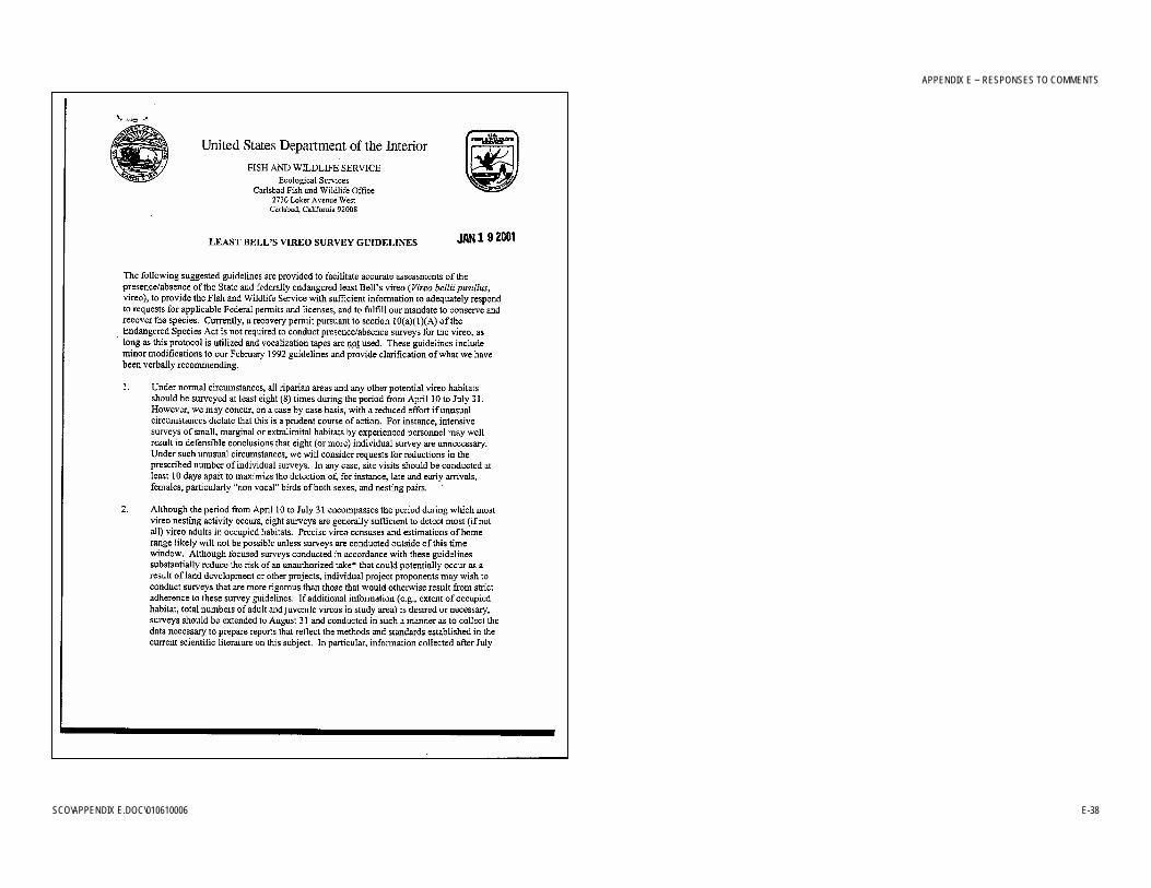
APPENDIX E − RESPONSES TO COMMENTS
SCO\APPENDIX E.DOC\010610006 E-38

APPENDIX E − RESPONSES TO COMMENTS
SCO\APPENDIX E.DOC\010610006 E-39

APPENDIX E − RESPONSES TO COMMENTS
SCO\APPENDIX E.DOC\010610006 E-40

APPENDIX E − RESPONSES TO COMMENTS
SCO\APPENDIX E.DOC\010610006 E-41

APPENDIX E − RESPONSES TO COMMENTS
SCO\APPENDIX E.DOC\010610006 E-42
APPENDIX E − RESPONSES TO COMMENTS
SCO\APPENDIX E.DOC\010610006 E-43