state of orth arolina … b c d revised...the purpose of this letter is to provide additional...
TRANSCRIPT
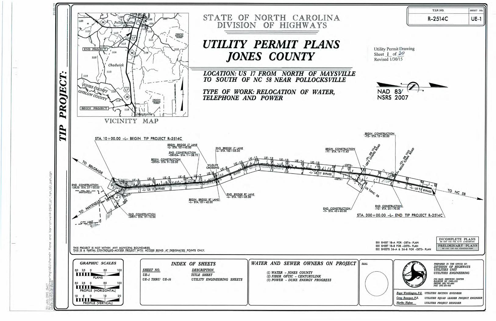
STATE OF NORTH CAROLINA
DEPARTMENT OF TRANSPORTATION PAT L. MCCRORY ANTHONY J. TATA
GOVERNOR SECRETARY
February 10, 2015 US Army Corps of Engineers NC Division of Coastal Management Regulatory Field Office 400 Commerce Avenue 2407 West 5th Street Morehead City, NC 28557 Washington, NC 27889 Attention: Mr. Tom Steffens Mr. Stephen Lane NCDOT Coordinator NCDOT Coordinator Dear Sirs: Subject: Application Modification Request for USACE Individual Permit, Section 401
Water Quality Certification, Neuse Riparian Buffer Authorization and CAMA Major Development Permit for the proposed improvement of US 17 from south of Belgrade at SR 1330/SR 1439 to the New Bern Bypass, in Onslow, Jones and Craven Counties. TIP No. R-2514 B, C & D.
References: NCDOT permit application dated November 14, 2014 NCDWR On Hold letter dated January 27, 2015 As you are aware, the North Carolina Department of Transportation (NCDOT), Division of Highways, proposes to improve US 17 from SR 1330/SR 1439 south of Belgrade to the New Bern Bypass. Permit applications for this project were submitted to the regulatory agencies on November 14, 2014. The purpose of this letter is to provide additional information requested by the agencies and provide updated application materials where changes in project plans have occurred. Unless provided with this revised application, all other information included in our original application has not changed. 1.0 Agency Comments on the Permit Application
1.1 N.C. Division of Water Resources In an e-mail dated January 5, 2015, David Wainwright of the N.C. Division of Water Resources (DWR) requested a listing of which impacted stream resources are perennial and which are intermittent.
MAILING ADDRESS: NC DEPARTMENT OF TRANSPORTATION PROJECT DEVELOPMENT AND ENVIRONMENTAL ANALYSIS 1598 MAIL SERVICE CENTER RALEIGH NC 27699-1598
TELEPHONE: 919-707-6100 FAX: 919-212-5785
WEBSITE: WWW.NCDOT.ORG
LOCATION: CENTURY CENTER, BUILDING B
1020 BIRCH RIDGE DRIVE RALEIGH NC 27610
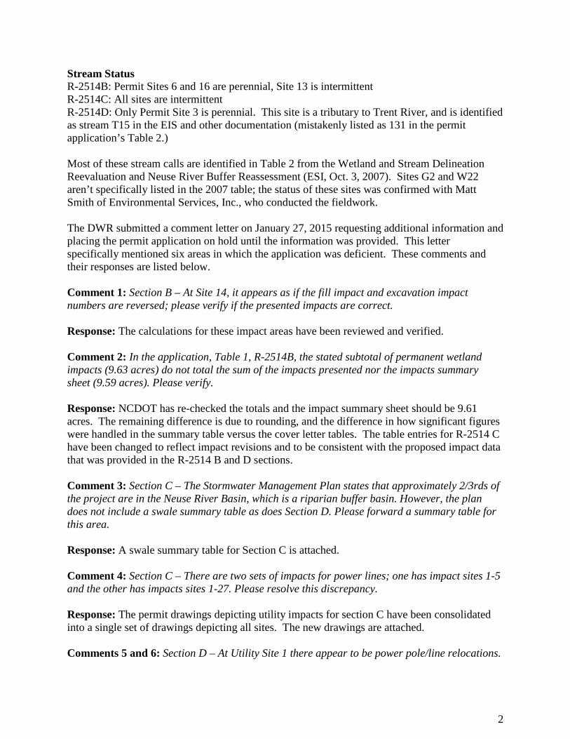
Stream Status R-2514B: Permit Sites 6 and 16 are perennial, Site 13 is intermittent R-2514C: All sites are intermittent R-2514D: Only Permit Site 3 is perennial. This site is a tributary to Trent River, and is identified as stream T15 in the EIS and other documentation (mistakenly listed as 131 in the permit application’s Table 2.) Most of these stream calls are identified in Table 2 from the Wetland and Stream Delineation Reevaluation and Neuse River Buffer Reassessment (ESI, Oct. 3, 2007). Sites G2 and W22 aren’t specifically listed in the 2007 table; the status of these sites was confirmed with Matt Smith of Environmental Services, Inc., who conducted the fieldwork. The DWR submitted a comment letter on January 27, 2015 requesting additional information and placing the permit application on hold until the information was provided. This letter specifically mentioned six areas in which the application was deficient. These comments and their responses are listed below. Comment 1: Section B – At Site 14, it appears as if the fill impact and excavation impact numbers are reversed; please verify if the presented impacts are correct. Response: The calculations for these impact areas have been reviewed and verified. Comment 2: In the application, Table 1, R-2514B, the stated subtotal of permanent wetland impacts (9.63 acres) do not total the sum of the impacts presented nor the impacts summary sheet (9.59 acres). Please verify. Response: NCDOT has re-checked the totals and the impact summary sheet should be 9.61 acres. The remaining difference is due to rounding, and the difference in how significant figures were handled in the summary table versus the cover letter tables. The table entries for R-2514 C have been changed to reflect impact revisions and to be consistent with the proposed impact data that was provided in the R-2514 B and D sections. Comment 3: Section C – The Stormwater Management Plan states that approximately 2/3rds of the project are in the Neuse River Basin, which is a riparian buffer basin. However, the plan does not include a swale summary table as does Section D. Please forward a summary table for this area. Response: A swale summary table for Section C is attached. Comment 4: Section C – There are two sets of impacts for power lines; one has impact sites 1-5 and the other has impacts sites 1-27. Please resolve this discrepancy. Response: The permit drawings depicting utility impacts for section C have been consolidated into a single set of drawings depicting all sites. The new drawings are attached. Comments 5 and 6: Section D – At Utility Site 1 there appear to be power pole/line relocations.
2

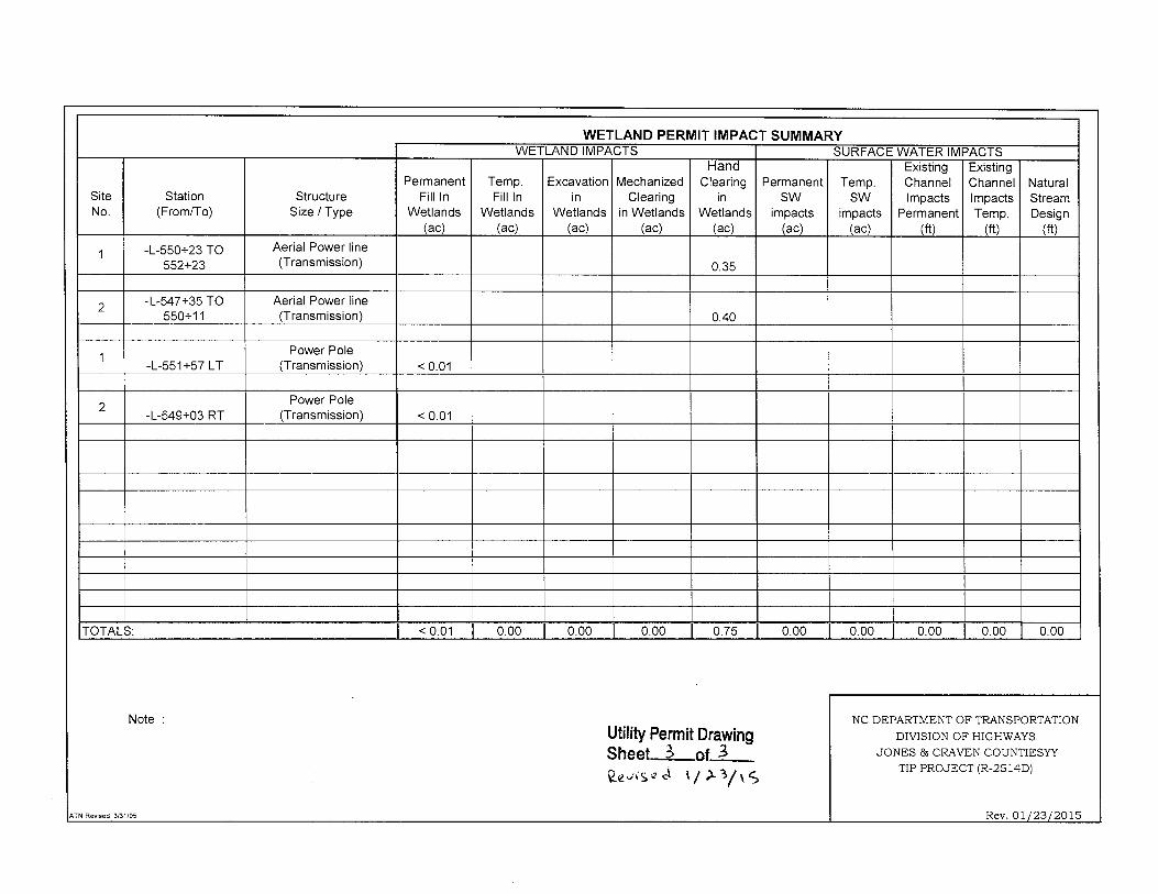
The amount of hand clearing requested seems to be excessive for the proposed activity. Please explain why this amount of clearing is necessary. At Utility Site 2 the amount of hand clearing requested seems excessive for the proposed utility relocation. Please explain why this amount of clearing is necessary. Responses to Comments 5 & 6: Further coordination with the utility companies has reduced the clearing impacts in this area of the project. However, this review revealed an error in the permit application at these impact sites. Specifically, the summary sheet incorrectly lists the impacts at Site 1 and 2 as 0.01 and 0.60 acres respectively, and showed the total impacts as 0.61 acres in the permit application. Utility Permit Drawings Sheet 2 correctly showed that Site 1 impacted 1.259533 acres and Site 2 0.5993 acre, a total of 1.86 acres. The Utility Permit Drawing data was incorrectly transferred to the summary sheet. The revised drawings included in this submittal show a much reduced footprint; with Sites 1 and 2 impacting 0.35 and 0.40 acre due to hand clearing. This reduced the impacts from 1.86 acres to 0.75 acre.
1.2 Corps of Engineers Comments In an email dated January 22, 2015 from Tom Steffens with the US Army Corps of Engineers (USACE) to Gordon Cashin with NCDOT, the USACE expressed concerns about a road paving “detour” project recently proposed near R-2514. This paving project will not be associated with R-2514. Furthermore, other than the onsite temporary detour described below, the NCDOT is not aware of any other elements in the works for R-2514, and believes the current permit drawings reflect the extent of the project’s impacts. The revised drawings now include a temporary onsite detour associated with Section C of the project. The additional impacts for this detour are depicted in an attached set of drawings. The Site 1D shown in these drawings is an extension of Site 1 on Sheet 58 of 62 of the permit drawings. The Site 2D in the detour drawings is an extension of Site 2 shown on Sheet 7 of 62 of the permit drawings. During phase I of construction, the proposed north bound lanes will be constructed while traffic is maintained on the existing alignment. During phase II, the temporary onsite detour will be utilized to carry traffic from the existing alignment to the newly constructed north bound lanes so the proposed southbound lanes, which follow the existing alignment, can be constructed. The additional temporary impacts are provided later in the revised impact tables. 2.0 Updates to the Permit Application
3.0 Summary of Impacts Permanent Impacts: Proposed permanent impacts for R-2514 B, C & D include fill, excavation, and mechanized clearing in 46.86 acres of wetlands, including 6.77 acres of riparian wetlands, and 40.09 acres of non-riparian wetlands. Proposed permanent impacts to jurisdictional streams
3

are 4,281 linear feet, including 279 feet of bank stabilization. Impacts due to utility work involve minimal fill in wetlands. Temporary Impacts: Proposed temporary impacts for R-2514 B, C & D include temporary fill, temporary excavation, in 0.59 acre of wetlands, including 0.13 acre of riparian wetlands, and 0.46 acre of non-riparian wetlands. There will be 397 linear feet of temporary impacts to jurisdictional streams including 112 feet of temporary impacts due to bank stabilization. There will also be 0.01 acre of temporary fill in wetlands in the hand clearing areas for erosion control measures Hand-Clearing: There will be 6.55 acres of hand-clearing in jurisdictional wetlands due to project construction and 2.59 acres of hand-clearing for utility relocations.
4.0 Summary of Mitigation The proposed construction of R-2514 B, C &D will impact 6.77 acres of riparian wetlands and 40.15 acres of non-riparian wetlands that will require mitigation (includes 0.06 acre of wetlands counted as a total take which will be mitigated at a 1:1 ratio). The project will impact 4,002 linear feet of jurisdictional stream that will require mitigation. In addition, the project will have unavoidable mitigable impacts to 148,206 square feet of riparian buffers, including 86,156 sq. ft. in Zone 1 and 62,050 sq. ft. in Zone 2 in the Neuse River Basin.
7.4 Impacts to Jurisdictional Resources Impacts to jurisdictional wetlands, surface waters and riparian buffers for R-2514 B, C & D were summarized in Tables 1, 2 and 3 respectively in the permit application. Tables 1 and 2 have been revised below to reflect the impact revisions resulting from: minor changes in design, presenting proposed impact data for all three sections consistent, and duplicate entries. The table entries that have changed are highlighted in gray. Totals may not match the sum of individual impacts provided on the attached impact summary sheets due to rounding.
4

Table 1. R-2514 B, C & D Wetland Impacts Permit
Drawing Site
Number
Map Label in FEIS (2011)
Type Permanent Impacts (ac.)
Temporary Impacts (ac.)
Mitigation Required***
(2:1)
R-2514B 1 241 Non-riparian 0.4 Yes 2 242 Non-riparian 0.19 Yes 3 32 Non-riparian <0.01 Yes 4 31 Non-riparian 0.01 Yes 5 27 Non-riparian 2.31 Yes 6 26 Riparian 1.2 Yes 7 24 Non-riparian 0.14 Yes 8 22 Non-riparian 0.07 Yes 9 245 Agricultural ditch 0.03 No
10 44, 45, W9 Riparian 3.70 0.06 Yes 11 42 Riparian 0.19 Yes 12 W8, 46 Riparian 0.01 0.01 Yes 14 48 Non-riparian 0.06 Yes 15 49 Non-riparian 1.22 Yes 16 W22, 250 Riparian 0.06 Yes
R-2514B Riparian: 5.16 0.07 R-2514B Non-riparian: 4.43 0.0
R-2514B Subtotal: 9.59 0.07
R-2514C 1 49 & 65 Non-riparian 4.07 0.22 Yes 2 49 & 65 Non-riparian 0.13 Yes
2D 65 Non-riparian 0.08 No 3 49 Non-riparian 0.06 0.01 Yes
4 67 (west
side), 65, 68 &75 (east)
Non-riparian 8.25 <0.01 Yes
5 69 & 70 Non-riparian 0.25 Yes 6 71 &72 Non-riparian 0.03 <0.01 Yes
7* 74 Non-riparian 0.35 0.01 Yes* 8 75 Non-riparian 0.73 Yes
9 77 west, 76 east Non-riparian 1.06 0.01 Yes
10 79 & 80 Non-riparian 1.10 Yes 11 78 Non-riparian 0.03 Yes 12 82 & 83 Non-riparian 0.50 Yes
13 west 85 & 86, east 84 Non-riparian 0.45 0.02 Yes
14 88 Non-riparian 1.93 Yes 15 89, 90, 91 Non-riparian 0.29 0.02 Yes
16 west 92, east 93 Non-riparian 0.73 0.09 Yes
17 94, G1 Riparian 0.01 Yes
5

Permit Drawing
Site Number
Map Label in FEIS (2011)
Type Permanent Impacts (ac.)
Temporary Impacts (ac.)
Mitigation Required***
(2:1)
20 100 Non-riparian 1.78 Yes 21 98 Non-riparian 0.25 Yes 23 65 & 63 Non-riparian 0.03 Yes
R-2514C Riparian: 0.01 0.0 R-2514C Non-riparian: 22.02 0.46
R-2514C Subtotal: 22.03 0.46
R-2514D 2 114 Non-riparian 2.54 Yes 3 131 Riparian 0.18 <0.01 Yes 4 132 & 135 Riparian 0.74 0.06 Yes 4 141 Non-riparian 0.20 Yes 5 166 Non-riparian 0.91 Yes 6 167 Non-riparian 1.73 Yes 7 175 Non-riparian 0.02 Yes 8 177 Non-riparian 0.25 Yes 9 181 Riparian 0.60 Yes
10 182 Non-riparian 0.40 Yes 11 184 Non-riparian 1.05 Yes 12 186 Non-riparian 0.37 Yes 13 246 Riparian 0.02 Yes 14 196 Non-riparian 0.34 Yes 15 229 Non-riparian 0.05 Yes 17 201 Non-riparian 1.55 Yes 18 202 Non-riparian 0.68 Yes 19 226 Non-riparian 1.55 Yes 20 225 Non-riparian 0.36 Yes 21 211 Non-riparian 1.62 Yes 22 See note** Non-riparian 0.02 Yes 23 D1, 217 Riparian 0.06 Yes
R-2415D Riparian: 1.6 0.06 R-2514D Non-riparian: 13.64
R-2514D Subtotal: 15.24 0.06
R-2514 B, C & D Total Riparian: 6.77 0.13 Non-riparian: 40.09 0.46 Grand Total: 46.86 0.59
* R-2514C Site 7 includes an additional 0.06 acre of un-impacted wetlands counted as a total take, not included inthe table above. This will be mitigated at a 1:1 ratio. ** Site 22 is a non-riparian wetland site identified during construction of R-2301A (New Bern Bypass) that had not been accounted for during the permit for that project. It was decided to include this site on the permit application for R-2514B, C & D to obtain after-the-fact authorization and provide mitigation. ***For permanent impacts
6
Table 1 continued. R-2514 B, C & D Wetland Impacts

Table 2. R-2514 Surface Water Impacts Permit
Drawing Site Number
Waterbody Labeled in
FEIS
Permanent (ft)
Permanent (ac.)
Temporary (ft)
Temporary (ac.)
USACE Mitigation
Required (2:1) R-2514B
6 W5 130 0.02 6 <0.01 Yes 6 W5 356 0.07 14 <0.01 Yes
6* W5 25 <0.01 10 <0.01 No 6* W5 25 <0.01 10 <0.01 No 13 W21 1151 0.60 60 0.04 Yes 13* W21 27 0.01 7 <0.01 No 13* W21 29 0.01 7 <0.01 No 13* W21 87 0.05 No 16 W22 120 0.04 25 0.01 Yes
R-2514B Total: 1,950 0.80 139 0.05 R-2514C
17 G1 109 0.01 Yes 18 G1 132 0.02 Yes
18* G1 20 <0.01 No 19 G2 106 0.01 Yes
19* G2 58 <0.01 No 22 W21 32 0.02 Yes 22 W21 10 0.01 No
R-2514C Total: 379 0.06 88 0.01
R-2514D 1 B5 218 0.01 31 <0.01 Yes
1* B5 16 No 3 131 5 <0.01 50 0.01 Yes 6 167 0.03 No 9 S18 196 0.05 20 <0.01 Yes
9* S18 18 No 13 S14 230 0.01 21 <0.01 Yes
13* S14 12 No 15 S9 292 0.06 27 <0.01 Yes
15* S9 26 No 16 S17 282 0.01 21 <0.01 Yes
16* S17 14 No 21 D2 644 0.06 Yes
R-2514 D Total: 1,953 0.23 170 0.01 R-2514B, C & D Total 4,282 1.1 397 0.09
*Denotes bank stabilization; when necessary, mitigation required by the USACE exceeds the amount required by NCDWR. The table includes 279 feet of permanent impacts and 112 feet of temporary impacts due to bank stabilization.
11.2 Compensation Table 5 breaks down the proposed permanent wetland impacts by HUC. The table entries that have changed are highlighted in gray.
7


(Version 1.2; Released July 2012)R-2514C County(ies): JONES Page 2 of 2
Sheet No.
Station(From / To)
Stream Crossing Station
Base Width(ft)
Front Slope(H:V)
Back Slope(H:V)
Drainage Area(ac)
Recommended Treatment Length
(ft)
Actual Length
(ft)
Longitudinal Slope
(%)Q2
(cfs)V2
(fps)Q10(cfs)
V10(fps)
Rock Checks Used
164+50 to172+54 RT -L-
195+45 to200+00 RT -L-
0
0
0
No1.73.40 340
0
1.50.30% 6.5
0
3.0 3.1
7.1
1.70
9.3
North Carolina Department of Transportation
Swales
173+08 -L- 0.0 3:1 3:1
1.6195+05 -L- 3.1
820
170
16
Project/TIP No.:
1.6
Highway Stormwater Program
17 No456
0.31%
0
0
0
0
0
0
0
0
0
0
0
0
0
8.4
Additional Comments
Have minimum design criteria, as presented in the NCDOT Best Management Practices Toolbox, Version 1 (March 2008), been met and verified? If No, provide further explanantion of why design criteria was not met.
STORMWATER MANAGEMENT PLAN FOR LINEAR ROADWAY PROJECTS
YES NO

RE
VISIO
NS
HYDRAULICSROADWAY DESIGN
ENGINEER ENGINEER
R/W SHEET NO.
SHEET NO.PROJECT REFERENCE NO.
R-2514C
$$$$$$
SY
STIM
E$$$$$
$$$$$$$$$$$$$$$$
DG
N$$$$$$$$$$$$$$$$
$$$$
US
ER
NA
ME$$$$
8/17/99
DO NOT USE FOR CONSTRUCTIONPRELIMINARY PLANS
MA
TC
HLIN
E -D
ET3- STA. 23+
00.0
0 SEE S
HEET 26
B
26A
SEE SHEET 44 FOR -DET3- PROFILE
NAD 83/ NSRS 2007NOTE: USE FOR CONSTRUCTION OF DETOUR ONLY
-DET3- DETOUR SHEET
22’
2’ PS
2’ PS
36" C
MP
30" R
CP
W/LT
W/LT
W/LT
W/LT
1SFD
36"
CO
NC
12’ S
OIL
24" RCP
S
10’ S
OIL/
GR
24" RCP
8’ S
OIL
24" CMP
W/LT
W/LT
W/LT
KE
NN
EL
10’ S
OIL/
GR
10’ S
OIL/
GR
18" RCP
18" RCP
S
1SBLKD
US 17 MAIN ST 28’ BST
DECK
DECK
T
T
T
T CC
CANISTER
TELEPHONE
1SFD1SFD
1SFD
S
TR
US
T
CO.
AN
D
TR
AD
ER
S
MA
NU
FA
CT
UR
ER
S
HA
RRIE
TT
BA
RB
ER
HEIR
S
EIP
EIP
EIP
132.0
0’
EXISTING R/W
EXISTING R/W
51
18" C
MP
15" H
DPE
15" RCP
ABAND
1SFDABAND
2SFD
15" RCP
15" CMP
15" RCP
13’
GR
10’ S
OIL
24" C
MP
R.S. P
RID
GE
N
ES
TA
TE
MA
YS
VIL
LE
DE
VE
LO
PM
EN
T
CO
RP
ER
ATIO
N
T
C
CTT
REPEATER
FOR THIS PEDNO RECORDS FOUND
DO
NELLE
MA
URIC
E
MYERS
GR. PARKING
S
BUS TR
EL
EV. 3
9.8
4’
SE
E S
HE
ET 1-
EB
M
#33
12.3
7’
+40.6
0
R.S. P
RID
GE
N
ES
TA
TE
MA
YS
VIL
LE
DE
VE
LO
PM
EN
T
CO
RP
ER
ATIO
N
US 17 MAIN ST 28’ BST
MA
YS
VIL
LE
DE
VE
LO
PM
EN
T
CO
RP
ER
ATIO
N
FR
AN
K JE
NKIN
S
HEIR
S
MA
RY
EL
LE
N
EA
DY, e
t ux
UNIT
ED
ST
AT
ES
DEP
AR
TM
EN
T
OF
AG
RIC
UL
TU
RE
UNIT
ED ST
ATES
DEP
ART
ME
NT
OF
AG
RIC
ULT
URE
et ux
VA
NES
SA
L. M
AR
TIN,
FR
AN
K J
EN
KIN
S
HEIR
S
2
14
4
146
147
1
147
146
143
144
145
147
143
A
10+00
PI Sta 16+66.85
D
L = 133.22’
T = 66.85’
R = 650.00’
DS = 45 mph
-D
ET3-
PT
Sta. 20+40.6
6
-D
ET3-
PC Sta. 21+
24.4
1
PI Sta 18+87.48
D
L = 307.44’
T = 154.26’
R = 1,500.00’
DS = 45 mph
e = .04
RO = 92’
-DET3-
-DET3- POT Sta. 10+00.00
-D
ET3-
PR
C Sta. 17
+33.2
2
-DET3- PC Sta. 16+00.00=
BEGIN CONSTRUCTION
-LBUS- POT Sta. 19+00.00 0.00 RT.
15
20
-DET3- POC Sta. 17+26.93
BEGIN DETOUR
PI Sta 23+24.44
D
L = 399.39’
T = 200.03’
R = 2,825.00’
DS = 45 mph
e = .03
RO = 69’
GRADE to DRAIN
WHEN DETOUR REMOVED)TEMP. 15" (REMOVE
26A01
26A02
DETOUR REMOVED)
(REMOVE WHEN
EST 7 SY GEOTEXTILE
EST 2 TONS
CL B RIP RAP
SITE 1D
SITE 1D
CLEARINGHAND
CLEARINGHAND
GRAPHIC SCALE
0’ 100’100’
ENGLISH
WETLAND AND SURFACE WATER IMPACTS PERMIT
SHEET 1 OF 6DETOUR PERMIT DRAWING SEE PROPOSED FINAL PROJECT PERMIT DRAWINGS FOR OTHER IMPACTS.
NOTE: ONLY ADDITIONAL IMPACTS DUE TO TEMPORARY DETOUR ARE SHOWN.
HC HCCLEARING
DENOTES HAND
F
F
F
F
ADDED 2/3/15

31.5
31.5
31.5
31.5
32.0
32.0
32.0
32.0
32.0
32.0
32.0
32.5
32.5
32.5
32.5
32.5
32.5
33.0
33.0
33.0
33.0
33.0
33.0
33.0
33.033.0
33.0
33.0
33.5
33.5
33.5
33.5
33.5
33.5
33.5 33.5
33.533.5
33.5
34.0
34.0
34.0
34.0
34.0
34.0
34.0
34.0
34.0
34.034.0
34.034.0 34.0
34.0 34.0
34.0
34.0
34.0
34.0
34.0
34.0
34.5
34.5
34.5
34.5
34.5
34.5
34.5
34.5
34.5
34.5
34.5
34.5
34.5
34.5
34.534.5
34.5
34.5
34.5
35.0
35.0
35.0
35.0
35.0
35.0
35.0
35.0
35.0
35.0
35.0
35.0
35.0
35.0
35.0
35.0
35.035.0
35.0
35.0
35.0
35.0
35.0
35.0
35.0
35.0
35.0 35.035.0
35.0 35.0
35.035.035.035.0
35.0
35.0
35.0
35.0
35.0
35.0
35.0
35.0
35.5
35.5
35.5
35.5
35.5
35.5
35.5
35.5
35.5
35.5
35.5
35.5
35.5
35.5
35.5
35.535.5
35.5 35.5
35.5
35.5
35.5
35.5
35.5
35.5
35.5
35.5
36.0
36.036.036.0
36.0
36.036.0 36.0
36.036.0
36.0
36.0
36.0
36.0
36.0
36.0
36.0
36.0
36.0 36.0
36.0
36.0
36.0
36.0
36.0
36.0 36.0
36.036.036.0
36.0
36.0
36.0
36.0
36.0
36.0
36.0
36.0
36.0
36.0
36.0
36.0
36.0
36.0
36.0
36.0
36.0
36.0
36.0
36.0
36.0
36.0
36.0
36.0
36.0
36.0
36.0
36.0
36.0
36.0
36.5
36.5
36.5
36.5
36.5
36.5
36.536.5
36.5
36.5
36.5
36.5
36.5
36.5
36.5
36.5
36.5
36.5
36.5
36.5
36.5
36.5
36.5
36.5
36.5
36.5
36.5
36.5
36.5
36.5
36.5
36.5
36.5
36.5
36.5
36.5
36.5
36.5
37.0
37.0
37.0
37.0
37.0
37.0
37.0
37.0
37.0
37.037.0
37.0
37.0
37.0
37.0
37.0
37.0
37.0
37.0
37.0
37.0
37.0
37.0
37.0
37.0
37.037.037.037.0
37.0
37.0
37.0
37.0
37.037.0
37.0
37.0
37.0
37.0
37.0
37.0
37.0
37.0
37.0
37.0
37.0
37.0
37.0
37.0
37.0
37.0
37.0
37.0
37.0
37.0
37.0
37.0
37.0
37.0
37.0
37.0
37.0
37.0
37.0 37.0
37.037.037.0
37.0
37.0
37.0
37.0
37.0
37.0
37.0
37.0
37.0
37.0
37.0
37.0
37.0
37.0
37.0
37.0
37.0
37.5
37.5
37.5
37.5
37.5
37.5
37.5
37.5
37.5
37.5
37.5
37.5
37.5
37.5
37.5
37.5
37.5
37.537.5
37.5
37.5
37.5
37.5
37.5
37.5
37.5
37.5
37.5
37.5
37.5
37.5
37.5
37.5
37.5
37.5
37.5
37.5
37.5
37.5
37.5
37.5
37.5
37.5
37.5 37.5
37.5
37.5
37.5
37.5
37.5
37.5
38.0
38.0
38.0
38.0
38.0
38.0
38.0
38.0
38.0
38.0
38.0
38.0
38.0
38.0
38.0
38.0
38.0
38.0
38.0
38.038.038.038.0
38.0
38.0
38.0
38.0
38.038.0
38.0
38.038.0
38.0
38.0
38.0
38.0
38.0
38.0
38.0
38.0
38.0
38.0
38.0
38.0
38.0
38.0
38.0
38.0
38.0
38.0
38.0
38.0
38.0
38.0
38.0
38.0
38.0
38.0
38.0
38.0
38.0
38.0
38.0
38.0
38.0
38.0
38.0
38.0
38.0
38.0
38.0
38.0
38.0
38.0
38.5
38.5
38.5
38.5
38.5
38.5
38.5
38.5
38.538.5
38.5
38.538.5
38.5
38.5
38.5
38.5
38.5
38.5
38.5
38.5
38.5
38.5
38.5
38.5
38.5
38.5
38.5
38.5
38.5
38.5
39.0
39.0
39.0 39.0
39.0
39.0
39.0
39.0
39.0
39.0
39.039.0
39.039.039.0
39.039.039.039.039.0
39.0
39.0
39.0
39.0
39.0
39.0
39.0
39.0
39.0
39.0
39.0
39.0
39.0
39.0
39.0
39.0
39.0
39.0
39.0
39.0
39.0
39.0
39.0
39.0
39.039.0
39.0
39.0
39.0
39.0
39.0
39.0
39.0
39.0
39.0
39.0
39.5
39.5
39.539.5 39.5
39.5
39.5
39.539.5
39.539.5
39.5
39.5
39.5
39.5
39.5
39.5
39.5
39.5
39.5
39.5
39.5
39.5
39.5
39.5
39.5
40.0
40.0 40.0 40.0
40.0 40.0
40.0 40.0 40.0
40.040.0
40.0
40.040.040.040.0
40.040.040.0
40.0
40.0
40.0
40.0
40.0
40.0
40.0
40.0
40.0
40.0
40.0
40.0
40.0
40.540.5
40.5
40.5 40.540.5
40.540.5
40.540.540.540.5
40.5
40.5
40.5
41.041.0 41.0
41.041.0 41.0 41.0 41.0 41.0 41.0
41.041.0
41.041.041.041.0
41.041.041.041.0
41.041.0
41.0
41.0
41.0
41.5
41.5
41.5
41.5
41.5
41.5
41.5
41.5
41.5
42.0
RE
VISIO
NS
HYDRAULICSROADWAY DESIGN
ENGINEER ENGINEER
R/W SHEET NO.
SHEET NO.PROJECT REFERENCE NO.
R-2514C
$$$$$$
SY
STIM
E$$$$$
$$$$$$$$$$$$$$$$
DG
N$$$$$$$$$$$$$$$$
$$$$
US
ER
NA
ME$$$$
8/17/99
DO NOT USE FOR CONSTRUCTIONPRELIMINARY PLANS
MA
TC
HLIN
E -D
ET3- STA. 23+
00.0
0 SEE S
HEET 26
B
26A
SEE SHEET 44 FOR -DET3- PROFILE
NAD 83/ NSRS 2007NOTE: USE FOR CONSTRUCTION OF DETOUR ONLY
-DET3- DETOUR SHEET
22’
2’ PS
2’ PS
36" C
MP
30" R
CP
W/LT
W/LT
W/LT
W/LT
1SFD
36"
CO
NC
12’ S
OIL
24" RCP
S
10’ S
OIL/
GR
24" RCP
8’ S
OIL
24" CMP
W/LT
W/LT
W/LT
KE
NN
EL
10’ S
OIL/
GR
10’ S
OIL/
GR
18" RCP
18" RCP
S
1SBLKD
US 17 MAIN ST 28’ BST
DECK
DECK
T
T
T
T CC
CANISTER
TELEPHONE
1SFD1SFD
1SFD
S
TR
US
T
CO.
AN
D
TR
AD
ER
S
MA
NU
FA
CT
UR
ER
S
HA
RRIE
TT
BA
RB
ER
HEIR
S
EIP
EIP
EIP
132.0
0’
EXISTING R/W
EXISTING R/W
51
18" C
MP
15" H
DPE
15" RCP
ABAND
1SFDABAND
2SFD
15" RCP
15" CMP
15" RCP
13’
GR
10’ S
OIL
24" C
MP
R.S. P
RID
GE
N
ES
TA
TE
MA
YS
VIL
LE
DE
VE
LO
PM
EN
T
CO
RP
ER
ATIO
N
T
C
CTT
REPEATER
FOR THIS PEDNO RECORDS FOUND
DO
NELLE
MA
URIC
E
MYERS
GR. PARKING
S
BUS TR
EL
EV. 3
9.8
4’
SE
E S
HE
ET 1-
EB
M
#33
12.3
7’
+40.6
0
R.S. P
RID
GE
N
ES
TA
TE
MA
YS
VIL
LE
DE
VE
LO
PM
EN
T
CO
RP
ER
ATIO
N
US 17 MAIN ST 28’ BST
MA
YS
VIL
LE
DE
VE
LO
PM
EN
T
CO
RP
ER
ATIO
N
FR
AN
K JE
NKIN
S
HEIR
S
MA
RY
EL
LE
N
EA
DY, e
t ux
UNIT
ED
ST
AT
ES
DEP
AR
TM
EN
T
OF
AG
RIC
UL
TU
RE
UNIT
ED ST
ATES
DEP
ART
ME
NT
OF
AG
RIC
ULT
URE
et ux
VA
NES
SA
L. M
AR
TIN,
FR
AN
K J
EN
KIN
S
HEIR
S
2
14
4
146
147
1
147
146
143
144
145
147
143
A
10+00
PI Sta 16+66.85
D
L = 133.22’
T = 66.85’
R = 650.00’
DS = 45 mph
-D
ET3-
PT
Sta. 20+40.6
6
-D
ET3-
PC Sta. 21+
24.4
1
PI Sta 18+87.48
D
L = 307.44’
T = 154.26’
R = 1,500.00’
DS = 45 mph
e = .04
RO = 92’
-DET3-
-DET3- POT Sta. 10+00.00
-D
ET3-
PR
C Sta. 17
+33.2
2
-DET3- PC Sta. 16+00.00=
BEGIN CONSTRUCTION
-LBUS- POT Sta. 19+00.00 0.00 RT.
15
20
-DET3- POC Sta. 17+26.93
BEGIN DETOUR
PI Sta 23+24.44
D
L = 399.39’
T = 200.03’
R = 2,825.00’
DS = 45 mph
e = .03
RO = 69’
GRADE to DRAIN
WHEN DETOUR REMOVED)TEMP. 15" (REMOVE
26A01
26A02
DETOUR REMOVED)
(REMOVE WHEN
EST 7 SY GEOTEXTILE
EST 2 TONS
CL B RIP RAP
SITE 1D
SITE 1D
CLEARINGHAND
CLEARINGHAND
GRAPHIC SCALE
0’ 100’100’
ENGLISH
WETLAND AND SURFACE WATER IMPACTS PERMIT
SHEET 2 OF 6DETOUR PERMIT DRAWING SEE PROPOSED FINAL PROJECT PERMIT DRAWINGS FOR OTHER IMPACTS.
NOTE: ONLY ADDITIONAL IMPACTS DUE TO TEMPORARY DETOUR ARE SHOWN.
HC HCCLEARING
DENOTES HAND
F
F
F
F
ADDED 2/3/15

LIMITSCLEARING
WLB
WETLAND AND SURFACE WATER IMPACTS PERMIT
SHEET 3 OF 6DETOUR PERMIT DRAWING
00
00
1010
1010
2020
2020
3030
3030
4040
4040
5050
5050
6060
6060
7070
7070
8080
8080
9090
9090
100100
100100
110110
110110
120120
120120
130130
130130
140140
140140
150150
150150
$$$$$$
SY
STIM
E$$$$$
$$$$$$$$$$$$$$$$
DG
N$$$$$$$$$$$$$$$$
$$$$
US
ER
NA
ME$$$$
8/23/99
PROJ. REFERENCE NO. SHEET NO.0
40 40
50 50
30 3019+50.00
40 40
50 50
30 30
20+00.00
40 40
50 50
30 3020+50.00
40 40
50 50
30 3021+00.00
40 40
50 50
30 3021+50.00
40 40
50 50
30 3022+00.00
X-137R-2514C
-DET3-
5 10
36.87
2.50:12.50:1
0.0400.040
37.81
2.50:12.50:1
0.0400.040
38.31
2.50:12.50:1
0.0270.027
38.03
2.50:12.50:1
0.0050.005
38.01
2.50:12.50:1
0.0170.017
37.88
2.50:12.5
0:10.0300.030
ADDED 2/3/15

RE
VISIO
NS
HYDRAULICSROADWAY DESIGN
ENGINEER ENGINEER
R/W SHEET NO.
SHEET NO.PROJECT REFERENCE NO.
R-2514C
$$$$$$
SY
STIM
E$$$$$
$$$$$$$$$$$$$$$$
DG
N$$$$$$$$$$$$$$$$
$$$$
US
ER
NA
ME$$$$
8/17/99
DO NOT USE FOR CONSTRUCTIONPRELIMINARY PLANS
MA
TC
HLIN
E -D
ET3- STA. 23+
00.0
0 SEE S
HEET 26
A
26B
SEE SHEET 44 FOR -DET3- PROFILE
NAD 83/ NSRS 2007
NOTE: USE FOR CONSTRUCTION OF DETOUR ONLY
-DET3- DETOUR SHEET
22’
2’ PS
2’ PS
24" R
CP
INV
=35.2
0’
INV
=34.9
9’
T
60
83
24" RCP
12’ B
ST
FA
MIL
Y CIR
CLE
LN 10’ S
OIL/
GR
1SBLK
1SFD
72" C
HL
GEN
FU
EL
W/LT
35
BW
18" RCP
CAN
MTL
1SFD
10’ S
OIL/
GR
48" PLASTIC
G
CAN
18" HDPERIP RAP
1SFD
12’ S
OIL/
GR
18" RCP
RUIN
W/LT
W/LT
W/LT
HT
R
AB
AN
D
MTL
CAN
HTR
S
1SFD
10’ S
OIL/
GR
9’ SOIL
RIP RAP RIP RAP
24" RCP
1SFD
S
S
W/LT
RUINS
RUIN
S
25’
GR
AS
S
18" RCP
24" CONC
DE
CK
T
T
T
T
TC
C C
C
C
C
C
C
C
C
METERELECTRIC
T HH
HH
UNABLE TO COLLECT DUE TO FENCE
PLACED AS PER UTILITY RECORD
RECORDS FOUNDNO ASSOCIATED
18" RCP
S
MTLG
24" CMP
10’ S
OIL/
GR
MARION G. HILL, et ux
DAVID WARD, ET UXLEAMON GODLEY HEIRS
ET UX
TIMMONS,
HORACEWARD
VERA LEE
EIP
EIP
EIP
EIP
EIP
EIPEIP
EIP
IRON
ANGLE
IRON
ANGLE
RAP
RIP 15’ S
OIL/
GR
AM
BROSE R
OBER
TS, JR.
SEPTIC SYSTEM
72" C
HL 3S
BW
SYSTEMSEPTIC
72" CHL 3SBW
SYSTEM
SEPTIC
US 17 MAIN ST 28’
BST
EDITH MATTOCKS, et ux
ROSALEE SMITH HEIRS
MIC
HE
AL F
RO
ST
LO
UIS
E
DU
DL
EY
HEIR
S
RO
LA
ND
BA
RB
ER
HEIR
S
UNIT
ED STATES DEP
ART
MEN
T OF A
GRIC
ULT
URE
CENTURYLINK
UNITED STATES DEPARTMENT OF AGRICULTURE
FRANK JEN
KINS HEIR
S
CHORD
3
4
5
6
7 89
1112
13
CHORD
+25.00 -L-151.00’ (LT.)
+95.00 -L-
140.00’ (LT.)
+22.21 -L-
+23.79 -L-145.00’ (LT.)
+38.00 -L-
136.00’ (LT.)
118.00’ (LT.)
145.00’ (LT.)
+07.00 -L-
.025.025
.03.0
3
PI Sta 23+24.44
D
L = 399.39’
T = 200.03’
R = 2,825.00’
PI Sta 28+77.74
D
L = 702.37’
T = 353.94’
R = 2,300.00’
DS = 45 mph
e = .03
RO = 69’
DS = 45 mph
e = .03
RO = 69’
-DET3-
INC.
11.5’
25
30
35GRADE to
DRAIN
GRADE to DRAIN
GRADE to DRAIN
WHEN DETOUR REMOVED)
TEMP. 24" (REMOVE
26B03
26B04
(REMOVE WHEN DETOUR REMOVED)
EST 14 SY GEOTEXTILE
EST 5 TONS
CL B RIP RAP
TEMP. FILL IN WETLANDS
SITE 2D
CLEARINGHAND
ENGLISH
T TFILL IN WETLAND
DENOTES TEMPORARY
WETLAND AND SURFACE WATER IMPACTS PERMIT
SHEET 4 OF 6DETOUR PERMIT DRAWING
GRAPHIC SCALE
0’ 100’100’
HC HCCLEARING
DENOTES HAND
F
F
F
F
ADDED 2/3/15

RE
VISIO
NS
HYDRAULICSROADWAY DESIGN
ENGINEER ENGINEER
R/W SHEET NO.
SHEET NO.PROJECT REFERENCE NO.
R-2514C
$$$$$$
SY
STIM
E$$$$$
$$$$$$$$$$$$$$$$
DG
N$$$$$$$$$$$$$$$$
$$$$
US
ER
NA
ME$$$$
8/17/99
DO NOT USE FOR CONSTRUCTIONPRELIMINARY PLANS
MA
TC
HLIN
E -D
ET3- STA. 23+
00.0
0 SEE S
HEET 26
A
26B
SEE SHEET 44 FOR -DET3- PROFILE
NAD 83/ NSRS 2007
NOTE: USE FOR CONSTRUCTION OF DETOUR ONLY
-DET3- DETOUR SHEET
22’
2’ PS
2’ PS
24" R
CP
INV
=35.2
0’
INV
=34.9
9’
T
60
83
24" RCP
12’ B
ST
FA
MIL
Y CIR
CLE
LN 10’ S
OIL/
GR
1SBLK
1SFD
72" C
HL
GEN
FU
EL
W/LT
35
BW
18" RCP
CAN
MTL
1SFD
10’ S
OIL/
GR
48" PLASTIC
G
CAN
18" HDPERIP RAP
1SFD
12’ S
OIL/
GR
18" RCP
RUIN
W/LT
W/LT
W/LT
HT
R
AB
AN
D
MTL
CAN
HTR
S
1SFD
10’ S
OIL/
GR
9’ SOIL
RIP RAP RIP RAP
24" RCP
1SFD
S
S
W/LT
RUINS
RUIN
S
25’
GR
AS
S
18" RCP
24" CONC
DE
CK
T
T
T
T
TC
C C
C
C
C
C
C
C
C
METERELECTRIC
T HH
HH
UNABLE TO COLLECT DUE TO FENCE
PLACED AS PER UTILITY RECORD
RECORDS FOUNDNO ASSOCIATED
18" RCP
S
MTLG
24" CMP
10’ S
OIL/
GR
MARION G. HILL, et ux
DAVID WARD, ET UXLEAMON GODLEY HEIRS
ET UX
TIMMONS,
HORACEWARD
VERA LEE
EIP
EIP
EIP
EIP
EIP
EIPEIP
EIP
IRON
ANGLE
IRON
ANGLE
RAP
RIP 15’ S
OIL/
GR
AM
BROSE R
OBER
TS, JR.
SEPTIC SYSTEM
72" C
HL 3S
BW
SYSTEMSEPTIC
72" CHL 3SBW
SYSTEM
SEPTIC
US 17 MAIN ST 28’
BST
EDITH MATTOCKS, et ux
ROSALEE SMITH HEIRS
MIC
HE
AL F
RO
ST
LO
UIS
E
DU
DL
EY
HEIR
S
RO
LA
ND
BA
RB
ER
HEIR
S
UNIT
ED STATES DEP
ART
MEN
T OF A
GRIC
ULT
URE
CENTURYLINK
UNITED STATES DEPARTMENT OF AGRICULTURE
FRANK JEN
KINS HEIR
S
CHORD
3
4
5
6
7 89
1112
13
CHORD
+25.00 -L-151.00’ (LT.)
+95.00 -L-
140.00’ (LT.)
+22.21 -L-
+23.79 -L-145.00’ (LT.)
+38.00 -L-
136.00’ (LT.)
118.00’ (LT.)
145.00’ (LT.)
+07.00 -L-
.025.025
.03.0
3
PI Sta 23+24.44
D
L = 399.39’
T = 200.03’
R = 2,825.00’
PI Sta 28+77.74
D
L = 702.37’
T = 353.94’
R = 2,300.00’
DS = 45 mph
e = .03
RO = 69’
DS = 45 mph
e = .03
RO = 69’
-DET3-
INC.
11.5’
25
30
35GRADE to
DRAIN
GRADE to DRAIN
GRADE to DRAIN
WHEN DETOUR REMOVED)
TEMP. 24" (REMOVE
26B03
26B04
(REMOVE WHEN DETOUR REMOVED)
EST 14 SY GEOTEXTILE
EST 5 TONS
CL B RIP RAP
34.0
34.0
34.0
34.0
34.0
34.5
34.5
34.5
34.5
34.5 34.5
34.5
35.0
35.0
35.0
35.0
35.0
35.0
35.0
35.0
35.0
35.0
35.0
35.0
35.0
35.0
35.0
35.0 35.0
35.035.0
35.0
35.0
35.0
35.0
35.0
35.0
35.0
35.0
35.0
35.5
35.5
35.5
35.5
35.5
35.5
35.5
35.5
35.535.5
35.5
35.5
35.5
35.5
35.5
35.5
35.5
35.5
35.5
35.5
35.5
35.5
35.5
35.5
35.5
35.5
35.5
35.5
35.5
35.5
35.5
36.0
36.0
36.0
36.0
36.0
36.0
36.0
36.0
36.0 36.036.0
36.0
36.0
36.0
36.0
36.0
36.0
36.036.036.0
36.0
36.0
36.0
36.0
36.0
36.0
36.0
36.0
36.0
36.0
36.0
36.0
36.0
36.0
36.0
36.0
36.0
36.0
36.0
36.0
36.0 36.0
36.0
36.0
36.0
36.0
36.0
36.0
36.0
36.0
36.0
36.0
36.0
36.0
36.0
36.0
36.0
36.0
36.0
36.0
36.0
36.0
36.0
36.0
36.0
36.0
36.0
36.5
36.5
36.5
36.5
36.5
36.5
36.5
36.5
36.5
36.5
36.5
36.5
36.536.5
36.5
36.5
36.5
36.5
36.5
36.5
36.5
36.5
36.5
36.5
36.5
36.5
36.5
36.5
36.5
36.5
36.536.5
36.5
36.5
36.5
36.5
36.5
36.5
36.5
36.5
36.5
36.5
36.5
36.5
36.5
36.5
36.5
36.5
36.5
36.5
36.5
37.0
37.0
37.0
37.0
37.0
37.0
37.0
37.0
37.0
37.0
37.0
37.0
37.0
37.0
37.0
37.0
37.0
37.0
37.0
37.0
37.0
37.0
37.0
37.0
37.0
37.0
37.037.0
37.0 37.0
37.0
37.0
37.0
37.0
37.0
37.0
37.0
37.0
37.037.0
37.0
37.0
37.0
37.0
37.0
37.0
37.0
37.0
37.0
37.0
37.0
37.0
37.0
37.0
37.0
37.0
37.0
37.0
37.0
37.0
37.0 37.0
37.0 37.0
37.0
37.0
37.0
37.0
37.0
37.0
37.0
37.0
37.037.0
37.0
37.0
37.0
37.0
37.0
37.0
37.0
37.0
37.0
37.0
37.0
37.0
37.0
37.0
37.0
37.0
37.0
37.0
37.0
37.0
37.0
37.0
37.0
37.0
37.0
37.0
37.0
37.0
37.0
37.0
37.0
37.5
37.5
37.5
37.5
37.5
37.5
37.5
37.5
37.5
37.5
37.5
37.5
37.5
37.5
37.5
37.5
37.5
37.5
37.5
37.5
37.5
37.5
37.5
37.5
37.5
37.5
37.5
37.5
37.5
37.5
37.5
37.5
37.5
37.5
37.5
37.5
37.5
37.5
37.5
37.5
37.5
37.5
37.5
37.5
37.5
37.5
37.5
37.5
37.5
37.5
37.5
37.5
37.5
37.5
37.5
37.5
38.0
38.0
38.0
38.0
38.0
38.0
38.0
38.0
38.0
38.0
38.0
38.0
38.0
38.0
38.0
38.0
38.0
38.0
38.0
38.0
38.0
38.0
38.0
38.0
38.0
38.0
38.0
38.0
38.0
38.0
38.0
38.0
38.0
38.0
38.0
38.0
38.0
38.0
38.0
38.0
38.0
38.0
38.0
38.0
38.0
38.0
38.0
38.038.0
38.0
38.0
38.0
38.0
38.0
38.0
38.0
38.0
38.038.0
38.0
38.0
38.0
38.0
38.0
38.0
38.0
38.0
38.0
38.0
38.0
38.0
38.0
38.0
38.0
38.0
38.0
38.0
38.0
38.0
38.0
38.0
38.0
38.0
38.0
38.0
38.0
38.0
38.5
38.5
38.5
38.5
38.5
38.5
38.5
38.5
38.5
38.5
38.5
38.5
38.5
38.5
38.5
38.5
38.5
38.5
38.5
38.5
38.5
38.538.5
38.5
38.5
38.5
38.5
38.5
38.5
38.5
38.5
38.5
38.5
38.5
38.5
38.5
38.5
38.5
38.5
38.5
38.5
38.5
38.5
38.5
38.5
38.5
38.5
38.5
38.5
38.5
38.5
38.5
38.5
38.5
38.5
38.5
38.5
38.5
39.0
39.0
39.0
39.0
39.0
39.0
39.0
39.0
39.0
39.0
39.0
39.0
39.0
39.0
39.0
39.0
39.0
39.0
39.0
39.0
39.0
39.0
39.0
39.0
39.0
39.0
39.0
39.0
39.0
39.0
39.0
39.0
39.0
39.0
39.0
39.039.0
39.0
39.0
39.0
39.0
39.0
39.0
39.0
39.0
39.0
39.0
39.0
39.0
39.0
39.0
39.0
39.039.0 39.0
39.039.
0
39.0
39.0
39.0
39.0
39.0
39.0
39.0
39.0
39.0
39.0
39.0
39.0
39.0
39.0
39.0
39.0
39.0
39.0
39.0
39.0
39.5
39.5
39.5
39.5
39.5
39.5
39.5
39.5
39.5
39.5
39.5
39.5
39.5
39.5
39.5
39.5
39.5
39.5
39.5
39.5
39.5
39.5
39.540.0
40.0
40.0
40.0
40.0
40.0
40.0
40.0
40.0
40.0
40.0
40.0
40.0
40.0
40.0
40.0
40.0
40.0
40.040.040.0
40.0
40.0
40.0
40.0
40.0
40.0
40.0
40.0
40.5
40.5
40.5
40.5
40.5
40.5
40.5
40.5
40.5
40.5
40.5
40.5
40.5
40.5
41.0
41.0
41.0
41.0
41.0
41.041.0
41.0
41.0
41.0
41.0
41.0
41.0
41.0
41.0
41.0
41.0
41.041.041.0
41.0
41.0
41.0
41.0
41.5
41.5 41.5
41.5
41.5
41.5
41.5
41.5
41.5
41.5
41.5
41.5
41.5
TEMP. FILL IN WETLANDS
SITE 2D
CLEARINGHAND
ENGLISH
T TFILL IN WETLAND
DENOTES TEMPORARY
WETLAND AND SURFACE WATER IMPACTS PERMIT
SHEET 5 OF 6DETOUR PERMIT DRAWING
GRAPHIC SCALE
0’ 100’100’
HC HCCLEARING
DENOTES HAND
F
F
F
F
ADDED 2/3/15

WLB
LIMITSCLEARING
SHEET 6 OF 6DETOUR PERMIT DRAWING
WETLAND AND SURFACE WATER IMPACTS PERMIT
00
00
1010
1010
2020
2020
3030
3030
4040
4040
5050
5050
6060
6060
7070
7070
8080
8080
9090
9090
100100
100100
110110
110110
120120
120120
130130
130130
140140
140140
150150
150150
$$$$$$
SY
STIM
E$$$$$
$$$$$$$$$$$$$$$$
DG
N$$$$$$$$$$$$$$$$
$$$$
US
ER
NA
ME$$$$
8/23/99
PROJ. REFERENCE NO. SHEET NO.0
40 40
50 50
30 3026+00.00
40 40
50 50
30 3026+50.00
40 40
50 50
30 30
27+00.00
40 40
50 50
30 3027+50.00
40 40
50 50
30 3028+00.00
40 40
50 50
30 30
28+50.00
40 40
50 50
30 30
29+00.00
40 40
50 50
30 30
29+50.00
X-139R-2514C
-DET3-
5 10
39.3139.31
2.50:12.50:1
0.0300.030
38.8038.80
2.50:12.5
0:10.0300.030
37.5537.55
2.50:12.5
0:10.0300.030
36.2236.22
2.50:12.5
0:10.0300.030
35.6235.62
2.50:12.5
0:10.0300.030
37.2737.27
2.50:12.5
0:1 0.0300.030
38.2738.27
2.50:12.50:1
0.0300.030
39.0439.04
2.50:12.5
0:10.0300.030
ADDED 2/3/15

.. .. .. .. .. .. .. .. .. .. .. .. .. .. .. .. z ..g .... ... .... .... w., :::;;., >=a "'" >-.. "' . .... .... .... ....
•oo· o·
~···· GRAPHIC SCALE
100'
I
• • • • • • • • • • •
DETAILL STANi5liii""mi! DITCH
(Nalias...l.)
FILL I~ WETLA~~f. * ~f.
't< ---- 't< ~f.
DENOTES MECHANIZED CLEARING
DENOTES HAND CLEARING
PIOJECT IU!~EIU!NCE NO.
R-2514C WON SHEET NO_
10/>DNI>.Y DESIGN ENGINEEI
SHIE NO.
4
HYDRAUUCS ENGINEER
··~------------------------------------------------------------------------------------------------------------------------------------------------------------------------------------------------~ .... -,
REVISED 2/3/15

.. .. .. .. .. .. .. .. .. .. .. .. .. .. .. .. z ..g .... ... .... .... w., :::;;., >=a "'" >-.. "' . .... .... .... .... ....
.....__ .....__
I I
I \._
\
r w
~
PIOJECT IU!~EIU!NCE NO. SHIE" NO.
R-2514C 4 WON SHEET NO.
10/>DNI>.Y DESIGN HYDRAUUCS ENGINEER ENGINEER
.... ~----------------------------------------------------------------------------------------------------------------------------------------------------------------------------------~
REVISED 2/3/15

co 1-w w J: Cl)
w w
!!1 Cl) 0 u;
0 1: ~ 0 ... ... . .,; 0 0 ..<: 0
~ + ~I ...q-
j " ~ ul ; iii Cl) ~
J _.... ., 1: ICI I l w ... 1: z ":i I! :::::i c ~ J: ~ .. u E
~ 1: I! ·~ w I!! I
i w ... _....
<=J! ... ~~ o•! :;:1! ~d;ii
.. .. .. .. .. .. .. .. .. .. .. .. .. .. .. .. z ..g .... ... .... .... w., :::;; .. ._ .. "'" >-.. "' . .... .... .... .... .... ....
MECHANIZED CLEARING
10
10
10
If
10 10
FILL IN 10
It
10
SITE 7
10
10
LIMY E. ElBA*
,-? il"' lOll ;-' I I --~ I _ .... _ \
~.... \
10
MECHANIZED CLEARING
10 10
DETAIL I SI'EC~~~ITCH
........
...~
:: .
\
-DIIV2A- STA. 10+25 TO STA. 11+20 Ill" Mln..D• 1.0 Ft.
II• 5.0 f1.
-1.- STA. 66 +00 lo STA. 71+30 LT DDE-~39 r:Y -1.- STA. 81+50 TO STA. 83+50 LT DDE~~7 Ci
10 10
10
lilTED STATES DEPARTIEIIT OF
It 10
010
-L- STA. 83+50 TO STA. 86+50 LT DDE-219 Ci
FILL IN EXCAVATION
IN WETLAND FILL IN WETLAND
Min. D• 0.5 Ft.
1:1- 5.0 ft •
10
-1.- STA. 86+50 lo STA. 19+00 LT DDE~ 30 Ci
10
SURFACE WATER IMPACTS PERMIT
100' 0'
~···· GRAPHIC SCALE
10
10
100'
I['IEJIHAELJSEII CIIIIPAIIY
10
10
• • • • • • • • • • •
PIOJECT IU!~EIU!NCE NO. SHIE" NO.
R-2514C 9 WON SHEET NO.
lf»DNI<Y DESIGN ENGINEEI
HYDRAUUCS ENGINEER
PERMIT DRAWING SHEET 20 OF 62
DENOTES FILL IN WETLAND
10
DENOTES EXCAVATION IN WETLAND
DENOTES MECHANIZED CLEARING
0 -1-w w J: Cl)
w w Cl)
0 0 . 0 0 + co co
~ Cl)
J I
w z :::::i J: u
~
REVISED 2/3/15

.. .. .. .. .. .. .. .. .. .. .. .. .. .. .. .. z ..g .... ... .... .... w., :::;;., >=a "'" >-.. "' . .... .... .... .... ....
co 1-w w J: Cl)
w w Cl)
0 0 . 0 0 + ~
~ Cl)
J I
w z :::::i J: u
~
I
\f I \ I .$- I r..:::::. • <t; I I .,...<ti-' ..1
<t; --~ t_} ...... --0"0~--,...-----==-'--- ..... -....,
-,.,\ I\\
I \ I I \
I \ \
\ ~
\ ' .,-.,
/\ I \
\
- \ \
(
• • • • • • • • • • •
PIOJECT IU!~EIU!NCE NO.
R-2514C WON SHEET NO •
10/oDNio.Y DESIGN ENGINEEI
SHIE' NO.
9
HYDRAUUCS ENGINEER
PERMIT DRAWING ~ ) 1 Sl:iEEJ8~1 OF 62
(
f~~/
,_.)
.... ~-----------------------------------------------------------------------------------------------------------------------------------------------------------------------------------------..
REVISED 2/3/15

~EXC:AVATIO~ IN WETLAND
US 17 MNN ST 28' BST
MECHANIZED CLEARING
EXCAVATION
.. .. NAD 8311'/sRS 2007
SITE 7 ENLARGEMENT NCDOT
~ rrzn
• • • • • • • • • • •
DENOTES EXCAVATION IN WETLAND
DENOTES FILL IN WETLAND
DENOTES MECHANIZED CLEARING
50' 0'
~···· 50'
I
DIVISION OF HIGHWAYS JONES COUNTY
PROJECT: 1-f.fdiA CR -251-40
US 17 FROM NORTH OF MAYSVILLE TO SOUTH OF
NC S8 NEAR POLLOCKSVILLE
22 OF 62
Revised

CAMA 404 Hand Existing Existing Permanent Permanent Temp. Excavation Mechanized Clearing Permanent Temp. Channel Channel Natural
Site Station Structure Fill In Fill In Fill In in Clearing in SW SW Impacts Impacts StreamNo. (From/To) Size / Type Wetlands Wetlands Wetlands Wetlands in Wetlands Wetlands impacts impacts Permanent Temp. Design
(ac) (ac) (ac) (ac) (ac) (ac) (ac) (ac) (ft) (ft) (ft)
1 -L- STA 10+00 TO ROADWAY 3.65 0.42 <0.01 -L- STA 19+49
2 -L- STA 21+50 RT ROADWAY 0.09 0.04
3 -L- STA 24+00 LT 18" RCP <0.01 0.04 0.02
4 -L- STA 22+95 RT TO ROADWAY 6.82 1.43 -L- STA 84+82 RT
4 -L- STA 30+11 LT ROADWAY <0.01
5 -L- STA 24+30 LT ROADWAY 0.03 0.11 0.11
6 -L- STA 62+27 LT TO ROADWAY <0.01 0.03 <0.01 -L- STA 84+82 LT
*7 -L- STA 76+79 LT TO ROADWAY 0.26 0.01 0.08 -L- STA 82+96 RT
8 -L- STA 87+00 RT ROADWAY 0.64 0.09
9 -L- STA 90+56 TO ROADWAY 0.89 0.17 -L- STA 97+96
10 -L- STA 99+50 RT TO BRIDGE 0.95 0.15 -L- STA 105+79 RT
11 -L- STA 106+50 LT ROADWAY <0.01 0.03
12 -L- STA 118+16 RT TO ROADWAY 0.45 0.05 -L- STA 124+70 RT
**SUBTOTALS THIS SHEET: 0.00 13.78 0.00 0.17 2.60 <0.01 0.00 0.00 0 0 0
NOTES: *Site 7 has an additional 0.06ac of unimpacted wetlands that are considered part of a total take but are not included in the impact summary table quantities above.** Totals may not match sum of individual impacts due to rounding.
SHEET 61 OF 62 (REV 1/30/2015)
JONES COUNTY
WETLAND PERMIT IMPACT SUMMARYWETLAND IMPACTS SURFACE WATER IMPACTS
N.C.D.O.T.DIVISION OF HIGHWAYS
PROJECT: 34442.1.4 (R-2514C)
US 17 FROM NORTH OF MAYSVILLE TO
SOUTH OF NC 58 NEAR POLLOCKSVILLE

CAMA 404 Hand Existing Existing Permanent Permanent Temp. Excavation Mechanized Clearing Permanent Temp. Channel Channel Natural
Site Station Structure Fill In Fill In Fill In in Clearing in SW SW Impacts Impacts StreamNo. (From/To) Size / Type Wetlands Wetlands Wetlands Wetlands in Wetlands Wetlands impacts impacts Permanent Temp. Design
(ac) (ac) (ac) (ac) (ac) (ac) (ac) (ac) (ft) (ft) (ft)
13 -L- STA 127+87 TO ROADWAY 0.34 <0.01 0.11 -L- STA 131+32
14 -L- STA 133+26 RT TO ROADWAY 1.52 0.41 -L- STA 151+44 RT
15 -L- STA 143+74 LT TO ROADWAY 0.05 0.15 0.09 -L- STA 151+54 LT
16 -L- STA 159+00 TO ROADWAY 0.51 0.06 0.16 -L- STA 164+07
17 -L- STA 172+50 54" RCP 0.01 <0.01 <0.01 0.01 109
18 -L- STA 180+50 LT ROADWAY 0.02 <0.01 132 20
19 -L- STA 194+89 BANK STABILIZATION** <0.01** 58** -L- STA 195+00 42" RCP 0.01 106
20 -L- STA 256+16 TO ROADWAY & 1.58 0.20 -L- STA 262+25 2-30" RCP
21 -L- STA 269+40 ROADWAY 0.23 0.02
22 -LBUS- STA 19+40 RT 48" RCP 0.02 0.01 32 10
23 -DRV1- STA 18+60 LT ROADWAY 0.01 0.02
***1D -DET3- STA 18+54 TO DETOUR 3 0.03 -DET3- STA 22+60
***2D -DET3- STA 25+93 TO DETOUR 3 0.08 0.05 -DET3- STA 28+54
*SUBTOTALS THIS SHEET: 0 4.24 0.08 0.23 1.00 0.08 0.06 0.01 379 88 0
*SUBTOTALS SHEET 1: 0 13.78 0.00 0.17 2.60 <0.01 0.00 0.00 0 0 0
*TOTALS: 0 18.02 0.08**** 0.40 3.60 0.08**** 0.06 0.01 379 88 0
NOTES: * Totals may not match sum of individual impacts due to rounding.** Bank Stabilization at Site 19 is due to placement of rip rap on sides of channel where existing retaining wall is removed and more natural geometry restored to channel.*** Detour impacts shown on separate DETOUR PERMIT DRAWINGS (6 sheets)****0.01 acre of Temporary Fill in Wetlands in the Hand Clearing areas for erosion control measures
SHEET 62 OF 62 (REV 1/30/2015)
WETLAND PERMIT IMPACT SUMMARYWETLAND IMPACTS SURFACE WATER IMPACTS
JONES COUNTY
PROJECT: 34442.1.4 (R-2514C)
US 17 FROM NORTH OF MAYSVILLE TO
N.C.D.O.T.DIVISION OF HIGHWAYS
SOUTH OF NC 58 NEAR POLLOCKSVILLE

~
I ~
~ ~ 0 :t; ;;; Cll
~ ~ c :::3
"' ~ ., :2 .<: .... a. ~ 'S .., a.;
~ ... !i
J ~ u ~ "" ;;; ~ ~
~ bl "(
l i • E s c I! ·~ "' ' ;!! ~ ~ ... ~
! ~
.. .. .. .. .. .. .. .. .. .. .. .. .. .. .. .. z ..g .... .... .... .... w., :::;; .. ._ .. "'" >-.. "'" .... .... .... .... .... ....
Lt) I"'""
1-w w J: V)
w w V)
0 0 . 0 0 + 00 -.o I"'""
~ V)
...!. I
w z ..... J: u
~
'' '' ''
-1.- n;., 151 +50 .., n;., 181+00 LT DDE-6255 CY
TI'JIO oiUnor• 0.. I lip IGp
\
\ \
-1.- STio.. 179+92 TO STA 1n+OB U
SITE 1
\
DETAILO SPECIAL CUT DITCH
(frWtllll lalolej
Min.D VM.
..... . ... .... -L- n;., 17H5o ro n;., 17S+5o (kT)
-L- nA.lll+OO 1o n;., 115+50 LT DDE-744 CY
BUFFER IMPACTS PERMIT
~AD s31i'!SRS 2007
~· . ~ I~GLI I ~-~·~·~·~·~ ........ ~ =n~·~~·~~·~~•~-•L---------~' GRAPHIC SCALE
@
ALLOWABLE IMPACTS ZONE 1
ALLOWABLE IMPACTS ZONE 2
MITIGABLE IMPACTS ZONE 1
ZONE 1 MITIGABLE
HISTORIC PROPERTY ELIGIBLE FOR NRHP
DETAILQ nlo.NDAAD l!lo.SE DITCH , ............
~ ¥aa.d• 1.0 Ft.
I• 2.0 A .
DETAILN IATEIIo.L 'V' DITCH
(I<Wtto s-11)
l'lOJECT IU!~EIU!NCE NO.
R-2514C WON SHEET NO.
10/oDNio.Y DESIGN ENGINEEI
SHIE NO.
16
HYDRAUUCS ENGINEER
BUFFER DRAWING SHEET 2 OF -4
REVISED 2/3/15