statement of reasons for decision - independent planning ......statement of reasons for decision 1...
TRANSCRIPT
Statement of reasons for decision
1
11 November 2019
Gazcorp Industrial Estate
State Significant Development Application (SSD 5248)
1. INTRODUCTION
1. On 2nd September 2019, the NSW Independent Planning Commission (Commission) received from the NSW Department of Planning, Industry and Environment (Department) a State Significant Development (SSD) Application (Application) lodged by Gazcorp Pty Ltd
(the Applicant) for the staged development of the Gazcorp Industrial Estate (Proposal) at 813-913 Wallgrove Road, Horsley Park NSW 2175 (Site). The Application seeks consent for a Concept Proposal (Concept Proposal) for the entire site and consent for Stage 1 of the Concept Proposal being the construction of a 45,225 m² warehouse and associated
infrastructure.
2. The Commission is the consent authority in respect of the Application under section 4.5(a) of the Environmental Planning and Assessment Act 1979 (EP&A Act) and clause 8A of the State Environmental Planning Policy (State and Regional Development) 2011 (SEPP SRD). This is because:
• the Application constitutes State Significant Development under section 4.36 of the EP&A Act as the Application involves the construction and operation of a warehouse and distribution facility and meets the criteria in Clause 12 of Schedule 1 under SEPP SRD; and
• the Department received more than 25 submissions from the public objecting to the application and the Applicant disclosed a reportable political donation. It is noted Fairfield City Council (Council) made an objection to the public exhibition of the Application, however, withdrew its objection following review of the Applicant’s Response to Submissions (RtS) report.
3. Professor Mary O’Kane, Chair of the Commission, nominated Chris Wilson (Chair), Wendy
Lewin, and Professor Chris Fell AM to constitute the Commission determining the Application.
1.1 Site and locality
4. The Department’s Assessment Report (the Department’s AR) noted that the Site is legally
described as Lot 5 in Deposited Plan (DP) 24094 at 813-913 Wallgrove Road, Horsley Park NSW 2175. The Site is approximately 52 hectares (ha) in area consisting of both industrial and environmental conservation zoned land.
5. The Department’s AR states the Site is characterised by “undulating topography including a hill located in the central part of the site, which slopes east to Wallgrove Road and west to
Reedy Creek. Reedy Creek flows from south to north where bushland along the western boundary contributes to the Reedy Creek riparian corridor. The site contains remnant
patches of natural vegetation, comprising mainly Cumberland Plain Woodland endangered
ecological community (EEC)”.

2
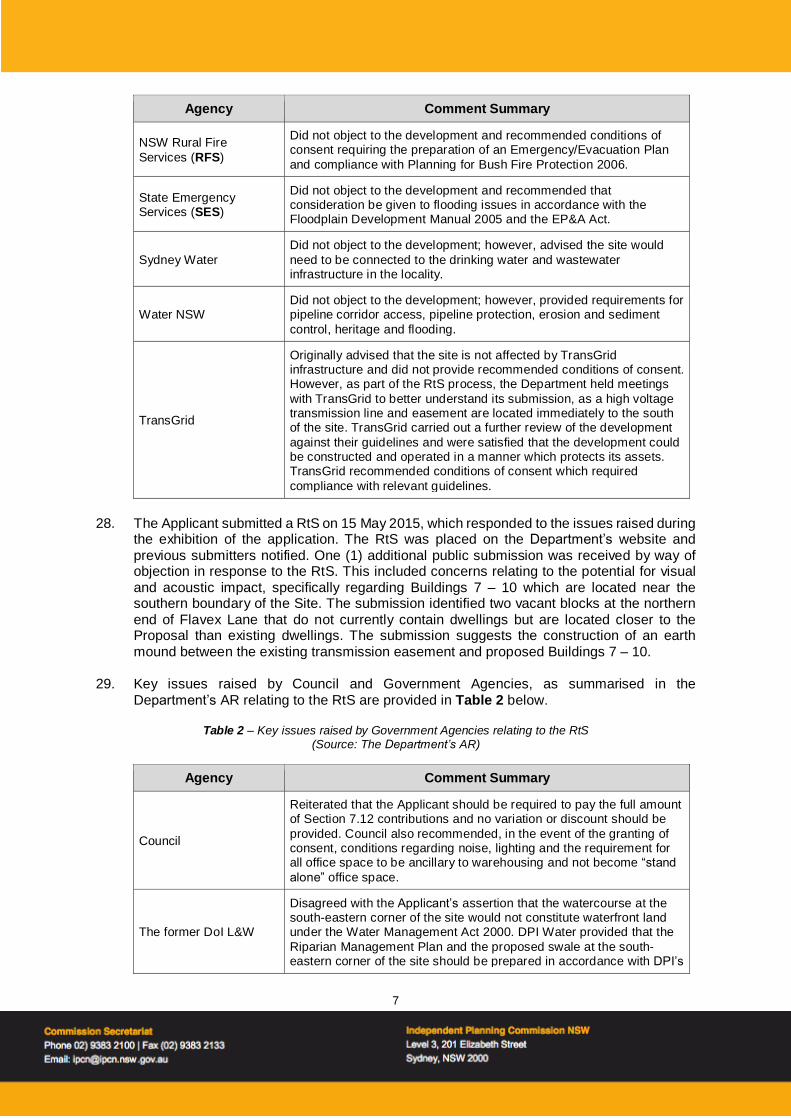
6. The Department’s AR states the Site is “bound by the Water NSW Warragamba to Prospect pipeline to the north, Wallgrove Road to the east, a TransGrid transmission line easement
to the south and Reedy Creek to the west”.
7. The Department’s AR notes that the Site is located within Precinct 8 of the Western Sydney
Employment Area (WSEA) which supports a mix of industrial and primary production land. Figure 1 identifies the location of the Site.
Figure 1 - Regional context map (Source: Department’s Assessment Report)
8. The Department’s AR notes the WSEA SEPP was gazetted in August 2009 with the aims to “promote economic development and employment, provide for the orderly and coordinated development of land, rezone land for employment or conservation purposes, ensure
development occurs in a logical, cost-effective and environmentally sensitive manner and
conserve and rehabilitate areas with high biodiversity, heritage or cultural value within the
WSEA”.
9. The Department’s AR notes that the WSEA SEPP has since been expanded and now incorporates more than 10,000 ha of predominantly industrial zoned land across 10 precincts in the Blacktown, Cumberland, Fairfield, Liverpool and Penrith Local Government Areas (LGA). The broader WSEA is expected to deliver more than 57,000 new operational jobs by 2044 and 155,000 operational jobs at full development.
10. The Department’s AR also notes the WSEA SEPP identifies the conceptual regional road alignment for the Southern Link Road (SLR), which will help accommodate travel demand generated by the WSEA precincts located south of the Water NSW pipeline. Figure 2 identifies the present alignment of the SLR in relation to the Site.

3
Figure 2 - Present alignment of the Southern Link Road (Source: Department’s Assessment Report)
1.2 Summary of Development Application
11. The Department’s AR states that “The Applicant is seeking development consent to
construct and operate an industrial and warehouse and distribution estate known as the
Gazcorp Industrial Estate at 813 – 913 Wallgrove Road, Horsley Park”.
12. The Department’s AR states that “The development includes an overarching Concept Proposal to guide the staged development of the site. The development also includes a
concurrent Stage 1 DA which includes site establishment works, road works and the
construction and operation of a warehouse and distribution building at proposed Lot 10.”
13. The Department’s AR identifies the Concept Proposal, as amended by the RtS, as involving the development of the Gazcorp Industrial Estate across 16 warehouse building envelopes including site levels, landscaping infrastructure services and development controls. These include:
• a maximum gross floor area (GFA) of 211,550m2, comprising 198,300m2 of warehouse floor space and 13,250m2 of office space;
• access to the estate via a signalised intersection in Wallgrove Road connecting to the internal road within the future Southern Link Road (SLR) alignment;
• individual on-site detention for each development lot, designed to contain up to the 100-year Average Recurrence Interval (ARI); and
• removal of 14.55 ha of native vegetation in accordance with a biodiversity offset strategy.
14. The Department’s AR notes the proposed development also includes a concurrent Stage 1 DA, as amended by the RtS (Stage 1 DA) for the construction and operation of a 45,225m2 warehouse and distribution facility with ancillary office space on proposed Lot 10, estate-wide bulk earthworks, site establishment works, construction of an internal road network and the extension of utilities and services to and within the site.
15. The Department’s AR notes that the Concept Proposal and Stage 1 DA is accompanied by a Planning Agreement for the provision of regional road infrastructure as there is no Special Infrastructure Contribution (SIC) that applies to the land.

4
16. The Department’s AR notes that the development as amended in the RtS, includes changes
to site access from Wallgrove Road to the SLR as preferred by Transport for NSW (TfNSW).
17. The Department’s AR notes that the Applicant had proposed as part of the Planning Agreement to construct the intersection of the SLR and Wallgrove Road and two lanes of
the SLR for 350m as works-in-kind (WIK) to offset contributions for regional transport. However, a WIK agreement for the construction of two lanes of the SLR is not possible at this stage given a decision has not been made on who will be the appropriate roads authority for the SLR. Consequently, the Planning Agreement has been drafted with sufficient flexibility to allow the 350m access road to be constructed as a private access until such
time as a designated roads authority is determined and the SLR is constructed.
18. The Department’s AR notes that the Concept Proposal and Stage 1 DA as amended through the RtS, also includes a revised biodiversity offset strategy, as requested by Office of
Environment and Heritage (OE&H) (now Heritage NSW, Community Engagement, Department of Premier and Cabinet).
19. The Concept and Stage 1 development proposals are identified in Figures 3 and 4.
Figure 3 - Concept proposal layout (Source: Department’s Assessment Report)

5
Figure 4 - Proposed Stage 1 development (Source: Department’s Assessment Report)
1.3 Stated need for proposal
20. The Department’s AR states that “the Applicant suggests the development of a large
strategic site in close proximity to the M4 and M7 Motorways and adjacent to the future SLR will generate direct new employment opportunities and promote future economic and
business development in the WSEA…the development would stimulate jobs and business
investment and deliver social and economic benefits to the area and Greater Sydney”.
2. THE DEPARTMENT’S CONSIDERATION OF THE APPLICATION
2.1 Key steps in the Department’s consideration of the Development Application
21. The Applicant submitted a Request for Director General’s Environmental Assessment
Requirements (DGR’s) (now Secretary’s Environmental Assessment Requirements) for State Significant Development on 21 March 2012.
22. The Department issued the Applicant DGR’s for the development on 14 May 2012.
23. The Applicant submitted the Application in March 2014.
24. The Department publicly exhibited the Application & EIS (SSD 5248) between 9 April 2014 and 23 May 2014.
25. The Department received a total of 42 submissions during the exhibition period including 9 from public authorities, one from Council, one from a special interest group and 31 from the general public, including one petition containing 17 signatures. Of the 42 submissions received, 32 objected to the development.
26. Key issues raised in submissions received during the exhibition period included visual impact, traffic, access and parking and noise and vibration. These are addressed in Sections 5.4 and 5.5 of the Department’s report.

6
27. Key issues raised by Council and Government Agencies, as summarised in the
Department’s AR, are provided in Table 1 below.
Table 1 – Key issues raised by Government Agencies (Source: The Department’s AR)
Agency Comment Summary
Council
Objected to the proposal, specifically on the grounds of acoustic and visual amenity impacts on adjoining residential properties and the
Applicant’s contention that Section 94A should not be paid. In addition, Council requested a community meeting be arranged and NSW Office of Environment and Heritage be advised of the reduction
of Critically Endangered Cumberland Plain Woodland.
Department of Primary Industries – Agriculture
(DPI Agriculture)
Did not object to the development and provided recommended conditions of consent including the requirement for sediment and erosion control measures, a Riparian Management Plan, consideration
of downstream impacts and a procedure to manage potential groundwater impacts.
The former Department
of Industry – Lands and Water (DoI L&W) (now Water Group and Crown
Lands of the Department)
Did not object to the development; however, requested updated plans showing all watercourses on site, clarification regarding the proposed
location of the south-eastern detention basin and clarification regarding the asset protection zone. Former DoI L&W also provided recommendations for dam decommissioning, the preparation of a
Riparian Management Plan and sediment and erosion control measures.
The former Department of Trade and Investment
– Resources & Energy (DTI R&E) (now Division of Resources and
Geosciences of the Department)
Did not object to the development; however, noted the site falls within
a transition area associated with the Austral Bricks sites as identified in its Mineral Resource Audit. In its submission, former DT&I stated that it contacted Austral Bricks as part of its review and Austral Bricks
raised no objection to the development.
Local Land Services
(LLS) – Greater Sydney Region
Did not object to the development and stated that the Native Vegetation Act 2003 does not apply to land within the Fairfield LGA
therefore LLS has no approval role for the clearing of native vegetation.
The former Office of Environment and
Heritage (OEH) (now Heritage Division of the Department of Premier
and Cabinet)
Did not object to the development however, raised the following concerns:
• the biodiversity impacts should be fully offset
• the defendable space within E2 Reedy Creek riparian zone is
inconsistent with the land use zone and is therefore considered unacceptable
• the watercourse at the south-eastern boundary of the site appears
to be removed. This should be retained and protected and enable the retention of the Alluvial Woodland EEC
• the methodology used in the Aboriginal Cultural Heritage
Assessment Report (ACHAR) should be revised to ensure it is clear that where test pit results indicate further archaeological investigation is warranted, expansion of those pits should occur
within the areas of impact under a salvage methodology.
Transport for NSW (TfNSW) and the former Roads and Maritime
Services (RMS) (now part of TfNSW)
Did not object to the development; however, stated that the preferred site access would be from the point where the future SLR meets Wallgrove Road and requested the Applicant re-design the
development accordingly.
7
Agency Comment Summary
NSW Rural Fire
Services (RFS)
Did not object to the development and recommended conditions of consent requiring the preparation of an Emergency/Evacuation Plan
and compliance with Planning for Bush Fire Protection 2006.
State Emergency Services (SES)
Did not object to the development and recommended that consideration be given to flooding issues in accordance with the Floodplain Development Manual 2005 and the EP&A Act.
Sydney Water
Did not object to the development; however, advised the site would
need to be connected to the drinking water and wastewater infrastructure in the locality.
Water NSW Did not object to the development; however, provided requirements for pipeline corridor access, pipeline protection, erosion and sediment
control, heritage and flooding.
TransGrid
Originally advised that the site is not affected by TransGrid infrastructure and did not provide recommended conditions of consent. However, as part of the RtS process, the Department held meetings
with TransGrid to better understand its submission, as a high voltage transmission line and easement are located immediately to the south of the site. TransGrid carried out a further review of the development
against their guidelines and were satisfied that the development could be constructed and operated in a manner which protects its assets. TransGrid recommended conditions of consent which required
compliance with relevant guidelines.
28. The Applicant submitted a RtS on 15 May 2015, which responded to the issues raised during
the exhibition of the application. The RtS was placed on the Department’s website and
previous submitters notified. One (1) additional public submission was received by way of objection in response to the RtS. This included concerns relating to the potential for visual and acoustic impact, specifically regarding Buildings 7 – 10 which are located near the southern boundary of the Site. The submission identified two vacant blocks at the northern
end of Flavex Lane that do not currently contain dwellings but are located closer to the Proposal than existing dwellings. The submission suggests the construction of an earth mound between the existing transmission easement and proposed Buildings 7 – 10.
29. Key issues raised by Council and Government Agencies, as summarised in the
Department’s AR relating to the RtS are provided in Table 2 below.
Table 2 – Key issues raised by Government Agencies relating to the RtS (Source: The Department’s AR)
Agency Comment Summary
Council
Reiterated that the Applicant should be required to pay the full amount of Section 7.12 contributions and no variation or discount should be
provided. Council also recommended, in the event of the granting of consent, conditions regarding noise, lighting and the requirement for all office space to be ancillary to warehousing and not become “stand
alone” office space.
The former DoI L&W
Disagreed with the Applicant’s assertion that the watercourse at the south-eastern corner of the site would not constitute waterfront land under the Water Management Act 2000. DPI Water provided that the
Riparian Management Plan and the proposed swale at the south-eastern corner of the site should be prepared in accordance with DPI’s

8
Agency Comment Summary
requirements. In its submission on the RtS, DPI Water requested the opportunity to provide comment on future development applications for
the site and require the Applicant to contact them should groundwater be intercepted at any time during works.
The former OEH
Did not support the Applicant’s proposed investigation of “alternative means” to purchase and retire the required ecosystem credits and
recommended the offsets be provided in accordance with the Framework for Biodiversity Assessment (FBA) and recommended conditions of consent to ensure this occurred.
TfNSW
Indicated support for the location of the site access via the point which
the future SLR alignment meets Wallgrove Road. Although TfNSW had concerns with the conceptual design of the intersection provided by the Applicant, it ultimately suggested the detailed design of a
suitable intersection configuration could occur as part of the Works Authorisation Deed (WAD) process post determination.
RFS
Supported the proposed bushfire mitigation measures and recommended conditions requiring compliance with Planning for
Bushfire Protection 2006 and Guidelines for the Preparation of an Emergency/Evacuation Plan.
Sydney Water
Stated it was generally satisfied with the proposed wastewater servicing strategy however stated its preference is for potable water to
be supplied from the Cecil Hills system rather than the proposed Minchinbury Reservoir System.
TransGrid
Noted the proposed swale in the south eastern corner of the site would be within 20 m of TransGrid easement which had the potential
to cause flood inundation, impede easement access and significantly change the ground level of the easement.
Water NSW Provided no further comment however, reiterated the requirement for the Applicant to consult with Water NSW at the detailed design stage.
The Environment
Protection Authority (EPA)
Did not object to the development and provided minimum
environmental performance criteria that should be met including water management, air quality, noise and vibration, waste management and contaminated land management.
2.2 The Department’s Assessment Report
30. The Department’s AR notes that the delay in finalising its assessment of the DA was
attributable to ongoing negotiations relating to the Planning Agreement, specifically the access road in relation to the SLR and its construction. Given it is still to be determined who will be the roads authority under the Roads Act 1993 for the SLR, a WIK for the proposed construction of that portion of the SLR required by the Applicant is not possible given there
is no authority to approve design, cost, construction and validation of the road.
31. The Department’s AR notes that the Department mediated between the Applicant, TfNSW and Council to enable the execution of a Planning Agreement that would facilitate a Satisfactory Arrangements Certificate (SAC) as required by Clause 29(3) of the WSEA
SEPP. A Planning Agreement was executed on 25 July 2019 and a SAC was issued on 29 July 2019. Detailed design work for SLR is presently underway by TfNSW on behalf of the Department.

9
32. The Department’s AR identified visual impacts, traffic, access and parking and noise and
vibration as the key impacts associated with the proposal.
33. The Department’s AR also identified a number of other impacts associated with the Application including stormwater management, flooding, contamination, biodiversity, air
quality, Aboriginal cultural heritage and bushfire management.
34. The Department’s AR states it has “taken into consideration the issues raised in all submissions, the Applicant’s EIS and RtS. The Department’s assessment has fully
considered all relevant matters under Section 4.15 of the EP&A Act, the object of the EP&A
Act and the principles of ecological sustainable development and is satisfied the impacts have been satisfactorily addressed by the development and through the Department’s
recommended conditions of consent”.
35. The Department’s AR notes the Proposal would “provide additional warehouse and industrial
space to support the continued growth and development of the WSEA as an identified
employment precinct and strategic centre in Western Sydney… the development will also support the productivity, growth and employment objectives of the A Metropolis for Three
Cities, the Greater Sydney Region Plan and the Western Parkland City”.
36. In relation to visual impacts, the Department’s AR notes that the Proposal would “result in
an altered visual landscape” but further states that the “area is part of the broader WSEA
transitioning from rural land uses to employment and industrial uses, commensurate with the land use zoning. The site has been zoned for industrial use as part of the WSEA since
2009”.
37. The Department’s AR states that it “has considered the development in the context of Clause 23 of the WSEA SEPP and is satisfied the development can be designed and constructed
to provide a suitable visual appearance at the boundary with residential areas”. It further states that the “visual impacts of the development are to be mitigated through several
measures including retaining vegetation and extensive planting of new screening vegetation
along the southern site boundary”.
38. In relation to built form, the Department’s AR includes a recommendation for “a condition
requiring future DAs include an urban design assessment to establish appropriate setbacks, layouts and building treatments noting the proposed development controls are the minimum
boundary setbacks”.
39. In relation to traffic impacts, the Department’s AR states the Department is “satisfied that the existing and future regional road network including Wallgrove Road, M7 Motorway and the
SLR can cater for the full build out of the Concept Proposal”. In addition, the Department’s AR recommends a condition requiring a CTMP be prepared and implemented to manage any impacts associated with the Stage 1 development.
40. In relation to noise impacts, the Department’s AR states that noise “during construction and operation, will be minimised and managed through the implementation of a comprehensive
CNMP and the construction of the acoustic barrier near sensitive receivers”.
41. The Department has drafted an instrument of consent which includes recommended conditions relating to the Concept Proposal, future DAs, the Stage 1 DA, and general environmental management, reporting and auditing. It includes specific conditions for Stage 1 to further minimise and manage residual impacts relating to acoustic, visual, traffic and parking, ecological and stormwater impacts. It also includes requirements for the preparation of a range of construction and operational management plans that must be prepared to the satisfaction of the Planning Secretary.
10
3. THE COMMISSION’S MEETINGS AND SITE INSPECTION 42. The Commission determined that a public meeting was not warranted in this instance given:
• The concerns raised in all submissions including those by way of objection were well documented; and
• Following the Department’s consultation will all previous objectors on the RtS including Council there was only 1 further submission by way of objection and the concerns raised within that submission are well documented.
43. However, as part of the Commission’s process in determining the Application, the Commission met with the Department and the Applicant as set out below. All meeting and site inspection notes were made available on the Commission’s website. The Commission invited the Council to meet but it advised that it had no further comment to make.
3.1 Meeting with the Department
44. On 19 September 2019, the Commission met with the Department to discuss the Proposal,
the Department’s AR, and the key issues identified by the Department as part of its assessment. A copy of the transcript and material provided by the Department was made available on the Commission’s website on 24 September 2019.
3.2 Meeting with the Applicant
45. On 19th September 2019, the Commission met with the Applicant to discuss the proposal.
A copy of the transcript was made available on the Commission’s website on 24 September 2019.
3.3 Site Inspection
46. On 24 September 2019, the Commission conducted an inspection of the Site (Site
Inspection). The Applicant identified the location of key aspects of the Proposal and key physical features of the landscape. The Commission’s Site Inspection notes were made available on the Commission’s website on 27 September 2019.
4. THE COMMISSION’S CONSIDERATION
4.1 Material considered by the Commission
47. In this determination, the Commission has carefully considered the following material
(Material):
• the DGR’s (now SEARs) dated 21 March 2012;
• the Environmental Impact Statement (EIS) dated 6 February 2014 and prepared by JBA (now Ethos Urban), and its accompanying appendices;
• the RtS dated 8 May 2015 and prepared by JBA (now Ethos Urban), and its
accompanying appendices;
• all submissions made to the Department during the public exhibition of the DA and EIS and up to the publication of the Department’s AR;
• the Department’s AR and recommended Development Consent, dated August 2019;
• information provided to the Commission at its meeting with the Department on 19 September 2019;
• the Applicant’s response to the Commission, dated 23 September 2019;
• the Applicant’s comments to the Commission, dated 24 September 2019;
11
• the Department’s response to the Commission, dated 3 October 2019; and
• the Department’s response to the Commission on the workability of conditions, dated 6 November 2019.
4.2 Mandatory considerations
48. In determining this application, the Commission has taken into consideration the following
relevant mandatory considerations insofar as they are relevant to the Proposal, as provided in s 4.15 of the EP&A Act (mandatory considerations):
• the provisions of all: o relevant environmental planning instruments; o proposed instruments that are or have been the subject of public consultation
under the EP&A Act and that have been notified to the Commission (unless the Secretary has notified the Commission that the making of the proposed
instrument has been deferred indefinitely or has not been approved); o relevant development control plans; o planning agreements that have been entered into under s 7.4 of the EP&A
Act, and draft planning agreements that the developer has offered to enter
into under s 7.4; o the Environmental Planning and Assessment Regulation 2000
(Regulations) to the extent that they prescribe matters for the purposes of s 4.15(1) of the EP&A Act;
that apply to the land to which the Application relates;
• the likely impacts of the Proposal, including environmental impacts on both the natural and built environments, and social and economic impacts in the locality;
• the suitability of the Site for the Proposal;
• submissions made in accordance with the EP&A Act and the Regulations; and
• the public interest.
4.3 Relevant Environmental Planning Instruments
49. The Commission considered the following EPIs in determining the Application:
• State Environmental Planning Policy (State and Regional Development) 2011;
• State Environmental Planning Policy (Western Sydney Employment Area) 2009
(WSEA SEPP);
• State Environmental Planning Policy (Infrastructure) 2007 (ISEPP);
• State Environmental Planning Policy 33 – Hazardous and Offensive Development (SEPP 33)
• State Environmental Planning Policy 55 – Remediation of Land (SEPP 55);
• Sydney Regional Environmental Plan No 20 – Hawkesbury-Nepean River (SREP 20);
• Fairfield Local Environmental Plan (FLEP) 2013; and
• Fairfield Citywide Development Control Plan (FDCP) 2013.
4.3.1 State Environmental Planning Policy (State and Regional Development) 2011
50. The Concept and Stage 1 DA being the development of warehouse and distribution centres
with a CIV of $174.5 million meets the criteria in Clause 12 of Schedule 1 of the SRD SEPP and is classified as SSD.
4.3.2 State Environmental Planning Policy (Western Sydney Employment Area) 2009 (WSEA)
51. The Department’s AR provides a detailed assessment of the principal development standards in Part 5 in WSEA SEPP. The Department has incorporated relevant conditions
12
of consent to address potential noise, traffic and visual impacts of the development.
4.3.3 State Environmental Planning Policy (Infrastructure) 2007 (ISEPP)
52. The development constitutes traffic generating development as it seeks approval for a
warehouse or distribution centre with more than 8,000m2 of GFA in accordance with Schedule 3 of the ISEPP.
53. The Application was referred to TfNSW to provide comment on the accessibility and traffic impacts of the proposal. TfNSW expressed initial concerns with the concept layout of the Wallgrove Road/SLR intersection, which did not align with the indicative SLR alignment. This position was revised after further discussions with the Department, the Applicant and the commencement of a detailed design review of the SLR.
54. The Department’s AR notes TfNSW is satisfied that a detailed design review can be facilitated through the Work Authorisation Deed (WAD) process post determination of the Stage 1 DA. TfNSW also recommended the Applicant prepare a CTMP prior to the commencement of construction.
55. The Department’s AR states it has “incorporated TfNSW requirements into the recommended conditions. The development is considered therefore consistent with the
ISEPP”.
4.3.4 State Environmental Planning Policy – Hazardous and Offensive Development (SEPP 33)
56. The Department’s AR states “the Applicant has reviewed the development in accordance
with SEPP 33 and advised that the proposed development is not potentially hazardous or
offensive”.
4.3.5 State Environmental Planning Policy – Remediation of Land (SEPP 55)
57. The Department’s AR notes the Applicant’s EIS included a contamination assessment for the site, which confirmed that a Remedial Action Plan (RAP) is not required. The Department’s AR states it has “included specific conditions for managing any unexpected
finds”.
4.3.6 Sydney Environmental Plan No 20 – Hawkesbury-Nepean River
58. The Department’s AR states “the proposed does not compromise the aims and objectives
of SREP 20”.
4.3.7 Fairfield Local Environmental Plan (FLEP) 2013
59. The Department’s AR notes it has consulted with Council throughout the assessment process and has considered all relevant provisions of FLEP and those matters raised by
Council in its assessment of the development.
4.4 Relevant Proposed Instruments
60. The Commission notes the Department’s AR did not address the Draft Remediation of Land SEPP, which was on exhibition until April 2018. The Commission notes the Draft Remediation of Land SEPP will replace SEPP 55 and will continue to require works on environmentally sensitive land or carried out in association with development are undertaken with development consent.

13
61. The Commission however notes that the assessment of the Application commenced prior to exhibition of the draft SEPP. The Commission has reviewed the EIS and is satisfied the development is consistent with the draft SEPP.
62. The Commission notes the Department has provided an assessment of the application
against the relevant EPI’s at Appendix C of its AR. The Commission is satisfied with the assessment and conclusions in the Department’s AR for the reasons set out in Appendix C.
4.5 Relevant Development Control Plans
4.5.1 Fairfield Citywide Development Control Plan (FDCP) 2013
63. DCP’s do not apply to SSD under Clause 11 of SREP SEPP. However, the Department has considered the relevant provisions of the FDCP in its assessment and where applicable included Council’s recommended draft conditions in the recommended instrument of consent.
4.6 Relevant Planning Agreements
64. The Applicant has entered into a Planning Agreement with the Minister for Planning to secure Development Contributions for regional infrastructure. This has enabled the Secretary to issue the certification required by Clause 29 of WSEA SEPP for all stages of the development.
4.7 Applicable Regulations
65. The Department’s AR states it “has undertaken its assessment of the development in
accordance with all relevant matters as prescribed by the regulations”.
66. The Commission has reviewed the Application and is satisfied it has adequately addressed the applicable regulations.
4.8 Likely impacts of the development on both natural and built environments
67. Key issues considered by the Commission in determining the Application relate to visual impacts, traffic, access and parking and noise and vibration.
4.9 Additional Considerations
68. In determining this Application, the Commission also considered the:
• NSW Industrial Noise Policy 2000 (INP);
• Noise Policy for Industry 2017 (NPI); and
• NSW Road Noise Policy 2011 (RNP)
69. The Commission accepts the key assessment issues raised in the Department’s AR being visual, traffic access and parking, noise and vibration impacts. However, due to the Proposal’s proximity to Reedy Creek, the Commission also considers stormwater impacts associated with the Proposal as a key issue as discussed further in this report. The following discussion therefore addresses the likely impacts of the Proposal, including environmental impacts on both the natural and built environments, and social and economic impacts in the
locality, and whether the Site is suitable for the Proposal.

14
4.10 Visual Impacts and Landscaping
Public Submissions
70. Submissions received during the exhibition of the EIS raised concern in relation to visual
impacts and landscaping.
71. The Commission acknowledges the visual impact concerns expressed in submissions which included:
• the Proposal not meeting requirements of Clauses 21 and 23 of the WSEA SEPP in relation to site topography and building height; and
• the proposed landscape buffer between the Site and nearby residential properties as being insufficient to offset the visual impact of the development described in the Stage
1 DA, as viewed from nearby residential properties.
Applicant’s Consideration
72. The Applicant’s EIS dated 6 February 2014 noted the predominant views from the nearby
dwellings are oriented to the east, west and south, and that views to the north are “compromised by existing mains power lines that run along the common boundary with the
subject site”:
73. The Applicant’s EIS states that visual impacts will be addressed as follows:
• “residential buildings are located some 300m from the site, which helps to minimise
the size and extent of the building mass when viewed in the context of the wider views available to the north;
• landscaping provided along the site’s boundary will help to soften and provide
additional screening to the proposed built form, thus ensuring that views from the residential dwellings are not dominated by built form; and
• the topography of the site ensures that many views to the development are screened by the natural lay of the land and existing vegetation, this is demonstrated in the
accompanying Sectional Drawings included at Appendix A”.
74. The Applicant’s EIS concluded that “the proposed development will not result in any
unacceptable adverse visual amenity impacts on the nearby residential properties”.
75. Following exhibition of the EIS, the Applicant’s RtS dated 8 May 2015 provided additional comments on the visual amenity impacts associated with the Proposal.
76. The Applicant’s RtS stated that:
• “there are no significant existing vistas towards the site from the nearest residences, and the views towards the site from the south is also impacted by an existing 330kV electricity transmission line (including pylon);
• the boundary treatment along the southern boundary of the site has been revised to include additional landscaping in front of the acoustic wall; and
• the Stage 1 warehouse building is predominantly located west of the existing transmission pylon…and is therefore partially screened from residents by the existing
riparian corridor of Reedy Creek”.
77. The Applicant’s RtS proposes additional measures to mitigate the visual impacts associated

15
with the Proposal as follows:
• “details of the Stage 1 building colour scheme, external cladding and finishes will be provided for the approval of the Director-General prior to the commencement of construction; and
• Future applications will be lodged providing detail on signage and lighting for the Stage
1 building”.
Department’s Assessment
78. The Department acknowledges in the AR that the Proposal will result in substantial changes
to views from rural residences to the south but also notes that:
• “the development is an appropriate and permissible use of the site due to its industrial zoning and strategic location in the WSEA; and
• the Department also notes the proposed mitigation measures and design controls will
go some way to screening the development and reducing its visual impact”.
79. The Department’s AR notes the landscape character on the southern interface should have “careful regard and provide an optimal urban design outcome for the adjacent sensitive
uses”.
80. The Department’s AR states the proposed landscape buffer is “acceptable on balance of needs for mitigating visual impacts, fulfilling TransGrid requirements and protecting people
and property”. The Department also acknowledges the WSFL corridor is proposed to run between Flavex Lane and the Site.
81. The Department’s AR states that the Proposal would “result in an altered visual landscape”.
However, it also recognises the Proposal is part of the broader WSEA, which is undergoing transition from rural land uses to employment and industrial land uses. The Department states that “the design and layout of the development is consistent with the scale and
character of existing industrial developments in the WSEA”.
82. The Department’s AR concludes that the Department “has considered the development in
the context of Clause 23 of the WSEA SEPP and is satisfied the development can be designed and constructed to provide a suitable visual appearance at the boundary with
residential areas”.
83. The Department’s AR outlines a series of recommended conditions that should be implemented to address visual impacts.
Commission’s Findings
84. The Commission accepts and adopts the findings of the Department outlined in paragraphs
78, 79, 80, 81, 82 and 83 above regarding the visual impacts of the Proposal.
85. The Commission acknowledges that TransGrid requirements limit the ability to undertake significant additional landscaping measures beyond those recommended in the Department’s AR.
86. The Commission accepts and adopts the Department’s conclusion in paragraph 81 that while there will be a visual change to the existing environment, the Proposal is consistent with the envisaged character and scale of industrial developments in the WSEA.
87. The Commission agrees with the Department’s statement that the southern interface

16
requires careful consideration with respect to adjoining residential uses. It also agrees that the revised landscape treatments submitted with the Applicant’s RtS will improve screening at this location. However, given the limited ability to provide additional landscaping in the Transgrid corridor that would screen Stage 1 when viewed from the east, the Commission considers that landscaping at a number of identified receptors should be provided at the
owners request to further mitigate view impacts to the north for Stage 1.
88. The Commission therefore proposes the inclusion of the following condition set out below. In making this recommendation the Commission has considered the Department’s response to the Commission dated 6 November 2019 in relation to the future Western Sydney Freight
Line Corridor. The Commission is satisfied that in the absence of any formal zoning reservation or corridor protection that the following condition is justified:
Offsite Visual Impact Mitigation
C98. For a period of 12 months from the commencement of operation, the owner of any
nearby residential receivers (Lot 2406 DP 1090132, Lot 2405 DP 1090132, Lot 2404 DP 1090132 and Lot 2403 DP 1090132) may ask the Applicant in writing to establish
landscape screening on the receivers land to minimise the visual impacts of the Stage 1 development on their residence (including its curtilage).
Upon receiving such a written request from the owner of these residences, the
Applicant must implement reasonable landscape screening in consultation with the
owner making the request.
The landscape screening must be implemented within 12 months of receiving the
written request, unless the Secretary agrees otherwise.
If the Applicant and the owner cannot agree on the measures to be implemented, or there is a dispute about the implementation of these measures, then either party may
refer the matter to the Secretary for resolution.
89. Based on the Material, the Commission finds that visual impacts are acceptable for the
reasons set out in paragraphs 84 to 87.
90. In relation to landscaping across the Site and access roads in general, the Commission notes that one of the objectives of the Greater Sydney Commission’s ‘A Metropolis of Three Cities’ (Objective 30) is to increase the urban tree canopy to: reduce ambient temperature; mitigate the heat island effect; and to provide (biodiversity) habitat. Having reviewed the Applicant’s landscaping plans, the Commission considers where practicable and feasible, additional landscaping should be provided within car parking areas and along access roads which supports tree species that with appropriate spacing will maximise areas of tree canopy when mature. The Commission therefore proposes that the following additional requirements be included in the Landscape Management Plan required by Condition C94:
(f) where practicable and feasible, provide for landscaping within car parking areas and along access roads that supports tree species which, with appropriate spacing and
when mature, will maximise areas of tree canopy; and
4.11 Traffic, Access and Parking Impacts
Public Submissions
91. A number of submissions received during the exhibition of the EIS raised concern in relation
to traffic, access and parking impacts. These concerns included:
• the preferred site access should be from the point where the future SLR meets Wallgrove Road;

17
• a review of the intersection designs and the impact on the LoS of the intersections;
• the exacerbation of existing local traffic impacts; and
• the proposed access directly off Wallgrove Road will cause additional traffic congestion on Wallgrove Road.
Applicant’s Consideration 92. The Applicant’s EIS considered the traffic, access and parking impacts of the Proposal and
is accompanied by a Traffic Impact Assessment (TIA) prepared by GHD. The applicant’s EIS states:
• “the preferred access solution was to create a single signalised access point to
Wallgrove Road. Under this preferred design solution the signalised intersection would be provided with a 100m right turn bay on the northern leg, with the provision for
pedestrian crossings on all legs. Based on the analysis undertaken by GHD the proposed access solution will provide for efficient and effective vehicular movements
in and out of the site with minimal disruption to traffic flows along Wallgrove Road and the future Southern Link Road;
• it is expected that the proposed Stage 1 warehouse will result in 157 trips per hour two way during peak times, with the overall site ultimately resulting in 600 trips per hour two way during peak times;
• SIDRA analysis confirms that the proposed new intersection would operate satisfactorily under the 2031 traffic flows in both the AM and PM peaks and 95th
percentile queues can be comfortably accommodated within the proposed bay lengths; and
• a total of circa 2,089 spaces (not including truck loading bays and docks) are proposed to be provided for the overall site which will be sufficient to cater for the development
and exceed the minimum parking requirements set out in the relevant guides and
standards.”
93. The Applicant’s EIS states the following in relation to construction traffic management:
• “construction is likely to result in increases of up to 27 vehicles per hour during peak
periods, which is well within the daily variation of traffic on the road network around the development; and
• it is anticipated that under a worst case scenario no more than 5 trucks per day would be required for the delivery of construction materials to site, except during the period
of concrete pouring, where the daily delivery may peak at 30 trucks per day. These deliveries are likely to occur outside of the peak traffic periods and will have negligible
impact on traffic on Wallgrove Road or the M7 Motorway which currently both have
high proportions of heavy vehicles.”
94. The Applicant’s RtS provided further assessment of the traffic, access and parking impacts
associated with the development, including an amended access arrangement to the Site off Wallgrove Road. The Applicant’s RtS was accompanied by an addendum TIA prepared by GHD.
95. The Applicant’s RtS states:
• “the proposed development has now been modified so that the internal road intersects with the future SLR approximately 350m of Wallgrove Road;
• SIDRA intersection modelling has been undertaken for the revised vehicle movement

18
split and site access location using the proposed 2031 traffic generation and background traffic assumptions. The analysis confirms that the intersection
arrangement is expected to operate at an acceptable level during both AM and PM peak periods; and
• “the proposed master plan has been modified to comprise of 1,500 parking spaces,
which is reduced from the 2,231 initially proposed in the EIS. This reduction in the number of parking spaces on site addresses a concern raised by TfNSW that the
original number of car parking spaces were excessive”.
96. As part of the amended access to the site, the Applicant has committed to construct a section of the proposed SLR extending 350m from Wallgrove Road to the Site as provided for in the executed Planning Agreement dated 25 June 2019.
Department’s Assessment 97. The Department’s AR states that the Applicant “has shown that under both an interim and
ultimate intersection design scenario the LoS would be satisfactory and the efficiency of
Wallgrove Road would not be overly impacted by the full development of the Concept
Proposal”.
98. The Department’s AR states that TfNSW is “now satisfied that the detailed design of the
intersection can be facilitated through a Works Authorisation Deed (WAD) process post determination as part of the Stage 1 development”. TfNSW has provided the Department
with conditions of consent to ensure a WAD is executed and the detailed design of the intersection approved by it prior to its construction.
99. The Department’s AR notes that during the operation of Stage 1, the TIA estimates that 157
vehicle movements during a peak hour would be generated, which is around 25% of the Proposal peak hour vehicle movements. As such, “the Stage 1 would not have significant
impacts on the efficiency and safety of Wallgrove Road”.
100. The Department also notes that the reduced parking provision submitted in the RtS is adequate and consistent with RMS Guidelines and rates approved at other developments in the WSEA.
101. The Department’s AR notes the estimated volume of construction traffic is “relatively low and would have minimal impacts on the efficiency and safety of local and regional roads. The
construction traffic impacts can be addressed in a Construction Traffic Management Plan
(CTMP) as part of the Construction Environmental Management Plan (CEMP)”.
102. The Department’s AR concludes that “traffic from the full development of the Concept
Proposal and Stage 1 development would be adequately accommodated on the existing and future (planned) local and regional road network. The development includes an appropriate
site access which will be delivered by the Applicant as part of the Stage 1 development”.
103. The Department’s AR outlines a series of recommended conditions to address residual impacts associated with traffic, access and parking.
Commission’s Findings
104. The Commission accepts and adopts the conclusions of the Department outlined in
paragraphs 97, 98, 99, 100, 101, 102 and 103 regarding the traffic, access and parking impacts of the Proposal.

19
105. The Commission notes the Applicant’s submission in paragraph 95, which amends the vehicular access arrangements to the site to align with the future SLR. The Commission further notes the Applicant has committed to construct a section of the proposal SLR extending from 350mm from Wallgrove Road in accord with the executed Planning Agreement.
106. The Commission accepts and adopts the Department’s assessment (refer paragraph 97) that the LoS would be satisfactory and the efficiency of Wallgrove Road would not be overly impacted by the full development of the Proposal.
107. The Commission supports the Department’s findings in paragraph 100 that the reduced parking provision submitted in the RtS is adequate and is consistent with the RMS Guide and rates approved at other developments in WSEA.
108. The Commission acknowledges and agrees with the Department’s findings in paragraph 102 that development from the Stage 1 and Concept Proposal can be adequately accommodated within the existing and future road network.
109. Based on the material, the Commission finds that traffic, access and parking impacts are
acceptable for the reasons set out in paragraphs 104 to 108.
4.12 Noise and Vibration Impacts
Public Submissions
110. A number of submissions received during the exhibition of the EIS raised concern in relation
to noise and vibration impacts. The concerns included:
• noise from the Proposal would exacerbate existing late-night noise from heavy vehicle movements on Wallgrove Road;
• the proposed 3m high acoustic fence is insufficient to mitigate potential noise impacts; and
• early morning and late-night noise from the development would disturb cattle and other livestock.
Applicant’s Consideration
111. The Applicant’s EIS addressed noise and vibration impacts of the Proposal. The EIS was
accompanied by a Cumulative Noise Study (CNS) for the Proposal, a Noise Emission Assessment (NEA) for the Stage 1 building and a Construction Noise and Vibration
Management Plan (CNVMP) prepared by Acoustic Logic.
112. According to the Applicant’s EIS, the NEA and CNS were prepared in accordance with the INP and RNP.
113. Based on the findings of the NEA and CNS, the Applicant’s EIS states “noise emissions
associated with vehicle movements and other operational aspects of the proposed
development comply with the relevant project specific noise criteria established for the
project”.
114. In relation to construction noise, the CNVMP states:
• “noise levels produced by the excavation equipment may exceed the noise goals at
adjacent residential premises when works are undertaken near the boundary of the site, even when quieter excavation methods such as a ripping are used; and

20
• main noise producing activities will be that attributed to the forming and pouring of the concrete floor slabs, and crane operation. These would be managed by placing the
plant as far as practicable from the sensitive receivers. It is expected that the adopted noise guidelines will generally be achieved during this phase except during louder
activities such as stripping out of formwork which will occur from time to time”.
115. The CNS and NEA set out the following recommendations:
• “for the warehouses along the southern boundary: The external southern façade wall to be constructed from Colorbond with 50mm glasswool insulation internally;
• the roof to be constructed from minimum 0.42mm sheet metal with 50mm glasswool insulation underneath;
• truck delivery drivers should limit the use of exhaust brakes on internal roads and Wallgrove Road; and
• where practical, trucks are to be switched off whilst in the loading dock and not to be left idling. This would apply to airbrake compressors to limit discharge within the
loading dock area”.
116. The CNS provided the following specific recommendation for the Stage 1 building:
• “an imperforated screen along the boundary near the residential receivers are recommended: the minimum height for the screen should be 3m (above the elevation
of the land), the barrier can be constructed with Colourbond, CFC sheet, perspex or
equal”.
117. Following a meeting with the Commission on 19 September 2019, the Commission requested additional information from the Applicant in relation to noise modelling
assumptions for trucks accessing the perimeter road in the location of the noise wall and southern interface for the Stage 1 building.
118. In response to paragraph 117, the Applicant submitted a letter to the Commission dated 23 September 2019 which stated that:
“the Noise Emission Assessment for Stage 1 is provided at Appendix Q2 of the EIS, and includes a SoundPLAN Model at its Appendix 2. The SoundPLAN Model identified the noise
sources that were used for the noise assessment, and shows a ‘line source’ around the internal road surrounding the building for both ‘day and evening period’ and ‘night period’
scenarios. This is consistent with the intended use of the site – that is, that heavy vehicles will load/unload around the loading dock areas, but may use the perimeter road for efficient
egress on arriving or exiting the site. Note that the SoundPLAN Model also shows ‘line sources; for the truck turning movements around the loading docks on the eastern side of
the building.”
Department’s Assessment 119. The Department’s AR notes the INP has been superseded by the NPI however, the
transitional arrangements provide that the INP was applicable when the SEARs were issued, and not modified, prior to the release of the NPI. As such, the Department’s AR stated “as
the EIS was lodged within two years of the issue of DGR’s for the development, the
Department is satisfied the INP remains applicable”.
120. The Department’s AR states in relation to construction noise “the most intrusive noise levels
would occur only at the boundaries of the site during excavation. The Department considers these works would be short lived and a mitigation strategy in accordance with the ICNG
could be prepared to lower construction noise at site boundaries at levels which do not

21
negatively impact the amenity of the sensitive receivers or provide respite periods”.
121. The Department’s AR states the erection of the 3m high acoustic barrier along the southern boundary of Lot 10 “should be as early as practicable during the construction phase to assist
in reducing construction noise impacts”.
122. The Department’s AR states in relation to traffic noise the “road traffic noise modelling was
based on a worst case scenario which included heavy and light vehicle movements in the evening period. Notwithstanding, the CNS concluded the development would comply with
all the relevant criteria”.
123. The Department’s AR states in relation to operational noise the “development would change the ambient sound experience of the locality however, the CNS and NEA demonstrate the
development would comply with the relevant noise criteria in accordance with the INP”. As such, “the Department is satisfied the operational noise impacts could be sufficiently
managed and it is the Department’s view that increasing the height of the proposed acoustic
barrier, increasing setbacks and/or altering the proposed hours of operation should not be
required”.
124. The Department’s AR concludes that “the Applicant can sufficiently manage construction and operational noise impacts through the implementation of mitigation and management
measures and the preparation and implementation of an updated and comprehensive
CNMP”.
125. The Department’s AR outlines a series of recommended conditions that should be implemented to address noise and vibration impacts.
Commission’s Findings
126. The Commission accepts and adopts the conclusions of the Department outlined in
paragraphs 119, 120, 121, 122, 123, 124 and 125 regarding the noise and vibration impacts of the Proposal.
127. The Commission acknowledges that the Applicant proposes to construct a 3m high acoustic barrier along the southern boundary of Lot 10 to mitigate operational noise but which may also assist in minimising construction noise impacts.
128. The Commission accepts the Department’s findings in paragraph 123 that operational noise impacts can be sufficiently managed to comply with the relevant noise criteria as outlined in the INP.
129. To ensure the 3m high acoustic wall enables the Proposal to meet the established operational noise goals at sensitive receivers, and where practical helps mitigate construction noise, the Commission considers that an additional Condition should be imposed requiring the consideration of noise absorbing material in the design of the wall, and that the design be signed off by a suitably qualified and experienced acoustic consultant
to validate its effectiveness.
130. Based on the material, the Commission finds that noise and vibration impacts are acceptable for the reasons set out in paragraphs 126 to 129 and on the basis that an additional condition
be imposed to provide specific and qualified validation for the construction of the noise wall, as set out in paragraph 129.
131. The Commission proposes the inclusion of the following condition:
22
NOISE WALL
C63 The Applicant must:
(a) complete the noise wall along the southern boundary of the site shown in Figure
6 in Appendix 5 within six (6) months of commencing any construction including
bulk earthworks;
(b) consider the use of absorptive material in the construction of the noise wall; and
(c) ensure that the design of the noise wall is endorsed by a suitably qualified and
experienced noise expert.
4.13 Stormwater Impacts
Public Submissions
132. A number of submissions received during the exhibition of the EIS raised concern in relation
to stormwater impacts.
Applicant’s Consideration
133. The Applicant’s EIS has considered the stormwater impacts of the Proposal and is
accompanied by a Stormwater Concept Plan prepared by Brown Consulting Engineers. The EIS states:
• “the proposal includes a detailed whole of site stormwater and drainage plan, as well
as temporary state on-site water detention (OSD) solution until the entire Site has been fully developed. As part of the initial stage of works it is proposed that interim OSD basins will be provided near the north-west and south east corners of the site;
• a stormwater management strategy has been prepared for the Site by Brown
Consulting…each of the proposed development sites within the Masterplan will ultimately be responsible for managing its own stormwater. This will be through the installation of individual underground on-site detention (OSD) systems; and
• stormwater from each development site will be conveyed through a below ground stormwater network contained within the internal access road reserve to one of three
outlets. Two outlets convey water into stormwater infrastructure on Wallgrove Road, and the third would discharge into Reedy Creek”.
134. Following exhibition of the EIS, the Applicant’s RtS provided further consideration of the Stormwater Concept Plan associated with the Proposal. The Applicant’s RtS was accompanied by an amended stormwater concept plan provided at Appendix G3 of the Applicant’s RtS.
135. The Applicant’s RtS stated:
• “a revision Stormwater Concept Plan has been prepared for the revised development
(see Appendix G). The intent of the proposed stormwater management system has not changed. However, the revised site layout has altered the location and size of the
stormwater basins under both the interim and ultimate (i.e. full site development) stormwater management strategy for the site”.
136. Following a meeting with the Commission on 19 September 2019, the Commission requested additional information from the Applicant in relation to what systems would be in place to protect Reedy Creek from a fuel leak or spill.
137. In response to paragraph 136, the Applicant submitted a letter to the Commission dated 23 September 2019 which stated that:

23
“the Stormwater Concept Plan was amended as part of the Response to Submissions Report and is provided at Appendix G3 of the Response to Submissions Report. Hydrocarbons were
not identified as a key pollutant concern in the stormwater assessment because hydrocarbons are normally only a key issue for developments that involve the storage or
handling of hydrocarbons (e.g. petrol stations). In this case, no storage or handling of hydrocarbons is proposed. Further, MUSIC Modelling, which is used to analyse the
effectiveness of the proposed stormwater management system in relation to the quality of stormwater being discharged, cannot model the removal of hydrocarbons. Rather, for a
project of this nature, ‘gross pollutants’ (i.e. rubbish) are able to be assessed, and a 90% reduction of ‘gross pollutants’ is required to be achieved through treatment. Gross Pollutant
Traps (GPTs) will be incorporated into the treatment train for Stage 1 as specified in the Stormwater Concept Plan to achieve this target…
…In this context, we note that, subsequent to the Stormwater Concept Plan being prepared (in 2015), Council issued a Stormwater Management Policy (2017), which specifies that
industrial develops (sic) of the scale proposed by Gazcorp must provide a device that specifically targets the removal of hydrocarbons from the treatment train. In light of Council’s
new policy, Gazcorp expects that a GPT capable of removing hydrocarbons would be stipulated by any suitably qualified person and mandated by Council through the detailed
design consultation process. Gazcorp would be satisfied with this outcome, and, to avoid any doubt, is willing to commit to ensuring a suitable device capable of removing
hydrocarbons is selected.”
Department’s Assessment
138. In accepting the Applicant’s Stormwater Concept Plan, the Department has proposed
Condition C46 of the development consent that will require the Applicant to “…design, install
and operate a stormwater management system…designed by a suitably qualified and experienced person whose appointment has been endorsed by the Planning Secretary…
and is prepared in consultation with Council.”
Commission’s Findings
139. The Commission accepts and adopts the proposed condition from the Department outlined
in paragraph 117 regarding the design, installation and operation of the stormwater management system.
140. The Commission accepts the response provided by the Applicant in paragraph 137 that a GPT is capable of removing hydrocarbons from the treatment train.
141. Given this undertaking, the Commission is satisfied that the risk of hydrocarbon spills on the site reaching Reedy Creek in the stormwater system is appropriately managed.
4.14 Social and Economic Impacts in the Locality
Applicant’s Consideration
142. With regards to the social and economic impacts of the Application, the Applicant stated in
the EIS that “once complete, the proposed development will result in capital expenditure of
$120 million and the creation of over 700 additional jobs in a variety of sectors including but
not limited to warehousing, distribution, freight transport and other industrial sectors”.
Department’s Assessment
143. The Department’s AR concludes that “the development would:

24
• provide a range of benefits for the region and the State, through a capital investment of $174.5 million in the Fairfield LGA
• provide a total of 1,500 operational jobs in western Sydney
• be consistent with the strategic objectives of WSEA SEPP and the Western City
District Plan to deliver employment generating development in western Sydney, close to key transport links
• not have a significant impact on the local environment.”
Commission’s Findings
144. The Commission accepts and adopts the conclusions of the Department outlined in
paragraph 143 above.
145. Based on the material, the Commission finds that the Proposal will deliver social and economic benefits as it will:
• create new opportunities for additional employment, as set out in paragraph 143;
• provide additional warehouse and industrial space to support the continued growth and expansion of the WSEA; and
• support the strategic objectives of the WSEA.
4.15 Section 7.12 Development Contributions
146. In the absence of a requirement to levy contributions in the recommended conditions of
consent, the Commission sought additional information from the Department. On the 2 October 2019 the Department provided the following response:
“The Department has recommended a condition (B1, Part B, Schedule 2 of the development
consent) that requires all future development applications to identify whether any Development Contributions Plan made by Council (under Section 7.12 of the EP&A Act)
applies. The Department recommends a specific condition be included in the recommended instrument requiring the Stage 1 development provide Section 7.12 development contributions. The condition could include:
Before the issue of a construction certificate for any part of the Stage 1 development, a
payment of a levy of 1% of the proposed cost of carrying out the development must be paid to Fairfield City Council under section 7.12 of the EP&A Act.”
147. The Commission accepts and adopts the Department’s recommendation in paragraph 146
and has therefore determined to impose the following condition:
DEVELOPER CONTRIBUTIONS
C30 Before the issue of a construction certificate for any part of the Stage 1 development,
a payment equal to 1% of the proposed cost of carrying out the development must be paid to Fairfield City Council under section 7.12 of the EP&A Act.
4.16 Other Relevant Issues
148. The Commission has considered other relevant issues made in relation to the Application
including:
• flooding;
• biodiversity;
25
• contamination;
• air quality;
• aboriginal cultural heritage; and
• bushfire management.
149. The Commission has reviewed the Applicant’s EIS, the Department’s AR and subsequent material and is satisfied the issues relating to the matters as outlined in paragraph 148 have been adequately considered and can be mitigated through recommended conditions of consent.
4.17 The Public Interest
Applicant’s Consideration
150. The Applicant has outlined its consideration against the objects of the EP&A Act in Section
5.7 and 9.3 of the EIS.
151. In relation to the precautionary principle, the Applicant’s EIS stated “the EIS has not identified
any serious threat of irreversible damage to the environment and therefore the precautionary
principle is not relevant to the proposal”.
152. In relation to intergenerational equity, the Applicant’s EIS stated “the proposal has integrated
short and long-term social, financial and environment considerations so that any foreseeable
impacts are not left to be addressed by future generations”.
153. In relation to conservation of biological diversity and ecological integrity, the Applicant’s EIS stated “the proposal will not have any significant effect on the biological diversity and
ecological integrity of the study area”.
154. In relation to improved valuation, pricing and incentive mechanisms, the Applicant’s EIS stated “mitigation measures for avoiding, reusing, recycling and managing waste during construction and operation would be implemented to ensure resources are used responsibly
in the first instance”.
155. The Applicant’s EIS acknowledges the Proposal has had regard to social, economic biophysical and ESD impacts of the proposal outlined in Section 9.1, Section 9.2 and Section 9.3 of the Applicant’s EIS.
Department’s Assessment
156. The Department’s AR has stated “the development is not anticipated to have any adverse
impacts on native flora or fauna, including threatened species, populations and ecological communities, and their habitats. The development requires the removal of native vegetation
which would be offset in accordance with relevant legislation. As such, the Department considers the development would not adversely impact on the environment and is consistent
with the objectives of the EP&A Act and the principles of ESD”.
157. The Department’s AR stated “the environmental impacts of the development would be appropriately managed via the recommended conditions. On balance, the Department
considers the development to be in the public interest”.
Commission’s Findings
158. The Commission has considered the objects of the EP&A Act, as set out in section 1.3 that
include:

26
(a) to promote the social and economic welfare of the community and a better environment by the proper management, development and conservation of the State’s natural and other resources,
(b) to facilitate ecologically sustainable development by integrating relevant economic, environmental and social considerations in decision-making about environmental planning and assessment,
(c) to promote the orderly and economic use and development of land,
(d) to promote the delivery and maintenance of affordable housing,
(e) to protect the environment, including the conservation of threatened and other species of native animals and plants, ecological communities and their habitats,
(f) to promote the sustainable management of built and cultural heritage (including Aboriginal cultural heritage),
(g) to promote good design and amenity of the built environment,
(h) to promote the proper construction and maintenance of buildings, including the protection of the health and safety of their occupants,
(i) to promote the sharing of the responsibility for environmental planning and assessment between the different levels of government in the State,
(j) to provide increased opportunity for community participation in environmental planning
and assessment.
159. The Commission accepts and adopts the Department’s assessment in paragraph 156 that the Proposal is generally consistent with the ESD principles because it achieves a balance between the relevant economic, environmental and social considerations that form part of
the decision-making process.
160. The Commission accepts and adopts the Department’s assessment in paragraph 157 that the Proposal is in the public interest because it demonstrates consistency with the objects of the EP&A Act set out in paragraph 156.
5. HOW THE COMMISSION TOOK COMMUNITY VIEWS INTO ACCOUNT IN MAKING DECISION
161. The views of the community were expressed through public submissions and comments
received (as part of exhibition and as part of the Commission’s determination process) as outlined in paragraphs 71, 91 and 110.
162. The Commission carefully considered all of these views as part of making its decision. The way in which these concerns were taken into account by the Commission is set out in section 4 above.
6. CONCLUSION: THE COMMISSION’S FINDINGS AND DETERMINATION 163. The Commission has carefully considered the Material before it.
164. The Commission finds that:
• the Proposal will have a positive impact associated with the provision of additional jobs in the WSEA (see paragraph 145);
• the proposed visual amenity, traffic, access and parking and noise and vibration impacts are acceptable and can be adequately managed through recommended

27
conditions of consent for the Proposal (see paragraphs 89, 109 and 130);
• the impacts associated with additional issues raised in the Department’s AR are acceptable and can be adequately managed through recommended Conditions of Consent for the Proposal (see paragraph 149);
• the Application supports the objectives of the WSEA SEPP (see paragraph 143); and
• the Application is generally consistent with ESD principles, the objects of the Act and is in the public interest (see paragraphs 159 and 160); and
• for the reasons set out above, the Site is suitable for the Proposal.
165. For the reasons set out in paragraph 164 above, the Commission has determined that consent should be granted to the Proposal subject to conditions which have been designed to:
• prevent, minimise and/or offset adverse environmental impacts;
• set standards and performance measures for acceptable environmental performance;
• require regular monitoring and reporting; and
• provide for the on-going environmental management of the development.
166. The reasons for the Decision are given in this Statement of Reasons Decision dated 11
November 2019.
Chris Wilson (Chair) Wendy Lewin Prof Chris Fell AM
Member of the Commission Member of the Commission Member of the Commission