statement of significance - nps.gov homepage (u.s
TRANSCRIPT

United States Coast Guard Fort Point Station Historic District Golden Gate National Recreation Area
Cultural Landscape Inventory Page 19
Statement of Significance General Statement In 1962 the Presidio of San Francisco became a National Historic Landmark (NHL). In 1993, the NHL documentation was updated to include a list of contributing buildings, structures, and objects. This update formally recognized the Fort Point Coast Guard Station as a component of the Presidio of San Francisco and identified its principal surviving structures as contributing features. This Cultural Landscape Inventory is intended to supplement the 1993 NHL nomination by inventorying the landscape features and characteristics that contribute directly to this component district of the Presidio of San Francisco or constitute to its setting. This CLI is also intended to elaborate upon the unique history of the Fort Point Coast Guard Station and clarify how it is distinct from the larger historical context of the Presidio in which the station is geographically situated. The period of significance for the Presidio of San Francisco was identified by the NHL nomination as 1776 to 1945. This is extended to 1964 for the Coast Guard Station. This inventory also introduces several new contextual themes which were not included in the NHL nomination. These additional themes are justified by the unique history and mission of the Coast Guard at its Fort Point Station, which was significantly different from that of the Army at the Presidio of San Francisco. Parent Landscape: The Presidio of San Francisco National Historic Landmark The National Historic Landmark documentation from 1993 noted that the "Presidio of San Francisco is the oldest Army installation operating in the American West and one of the longest-garrisoned posts in the country." [8-1]. The size and duration of this installation has resulted in a complex landscape in which many layers of history overlap in a relatively small geographical area. The NHL documentation goes on to explain, "The Presidio district is like a great landscape palimpsest, characterized by a rich and often dense overlay of resources from individual periods." [Sec. 8, pg. 3]. The complexity and diversity of the landscape is itself an important characteristic contributing to its unique historic value. Few places offer the opportunity to witness, in such close proximity, the military histories of the Spanish colonial, Mexican, and American national periods. As one of the U.S. Army's largest and most important garrisons, the Presidio of San Francisco has played a key role in nearly all of the country's military campaigns since the Mexican-American war of 1846-1848, when the garrison was acquired by the United States through conquest. These campaigns include the Civil War, most of the Indian wars in the West, the Spanish-American War, the Philippine Insurrection, the Mexican-Punitive Expedition, World War I, World War II, the Korean and Vietnam Wars, and the first Gulf War in Kuwait. Another factor contributing to the Presidio's unique historic value is its close relationship to San Francisco, and, in turn, San Francisco's regional importance in the American Far West.
The Presidio has been a primary and focal element of San Francisco's long ascendancy in the Far West; as the importance of the City has increased, so has the importance of the Presidio that has protected it and the Bay area beyond...The Presidio and the City of San Francisco are intertwined, most fundamentally through their sharing of a peninsula and through the Post's long-running function of guarding the entrance to the Bay. The reservation, now engulfed within the City, holds the most strategic position on the San Francisco Peninsula, commanding access and egress through the Golden Gate strait into San Francisco Bay. [Sec. 8, pg. 5]
San Francisco's position as a vibrant economic and cultural center has contributed to and augmented the importance of the Presidio by reason of association. But at the same time, the Presidio has contributed to San Francisco's own importance by protecting its vital resources and making it possible for the city to grow and flourish. This protection has not been limited to military defense but includes a range of other

United States Coast Guard Fort Point Station Historic District Golden Gate National Recreation Area
Cultural Landscape Inventory Page 20
services rendered by the Army and its various lessees at the Presidio. These include Army assistance during natural disasters, like the earthquake and fire of 1906; forest-fire air patrols conducted by Army pilots flying out of Crissy Field; medical care provided by the United States Public Health Service based at the Marine Hospital; and protection of commercial shipping provided by the aids to navigation and life- saving services of the U.S. Coast Guard. The 1993 NHL update recognized the national significance of the Presidio of San Francisco under combined National Historic Landmark Criteria 1, 4, 5, and 6, explaining that,
The property is composed of a wealth of historic, architectural and archeological resources that collectively comprise a distinctive entity of exceptional historical significance (Criteria 4, 5, and 6), and whose archeological study can amplify our understanding of those periods and peoples underrepresented in the existing historical record. As a vast district entity, the Presidio possesses exceptional value in illustrating the history of the United States through its association with important historical events and its outstanding representation of patterns of national development through multiple periods (Criterion 1). [Sec. 8, pg. 7]
It also recognized the Presidio's national significance under combined National Register Criteria A, C, and D, which closely parallel the National Historic Landmark Criteria. Criterion A recognizes the district's association with events that have made a significant contribution to the broad pattern of American history. Criterion C recognizes the district's embodiment of distinctive characteristics of several historic periods and methods of construction. And Criterion D recognizes the district's potential to yield valuable information through its historic archeological resources. The period of significance was listed as 1776 to 1945 (and 1951). The NHL update identified several contextual themes and sub-themes in which the Presidio of San Francisco expresses its significance. The language and organization of these themes were drawn from NHL guidelines that preceded the 1993 revision of the National Park Service's thematic framework. The nomination's list was comprised of the following items:
II. European Colonial Exploration and Settlement A. Spanish Exploration and Settlement V. Political and Military Affairs, 1783-1860 I. Mexican War, 1846-1848 K. The Army and the Navy VI. Civil War C. War in the West VII. Political and Military Affairs, 1865-1939 D. The United States Becomes a World Power, 1865-1914 E. World War I F. Military Affairs not related to World War I or World War II, 1914-1941 H. The Great Depression and the New Deal, 1929-1941 VIII. World War II B. War in the Pacific, 1941-1945 X. Westward Expansion of the British Colonies and the United States, 1763-1898 C. Military-Aboriginal American Contact and Conflict XVIII. Technology (Engineering and Invention) E. Military (Fortifications, Weapons, and War Vehicles)

United States Coast Guard Fort Point Station Historic District Golden Gate National Recreation Area
Cultural Landscape Inventory Page 21
These themes all relate principally to Army military operations associated with the Presidio. The NHL acknowledged that several other themes might also be cited to describe activities and facilities associated with the Presidio that were not directly related to military operations. However, it declined to elaborate on these themes, writing that, "with regard to several other National Historic Landmark themes/sub-themes, there is not sufficient contextual information at this time to establish significance at the national level." [Sec 8, pg. 9]. Among these excluded themes are those which describe the life-saving activities of the U.S.C.G. Fort Point Station. In the language of the pre-1993 revision, these themes are comprised of the following:
XIV. Transportation B. Ships, Boats, Lighthouses, and Other Structures
In the language of the post-1993 revision, they are:
II. Creating Social Institutions and Movements B. Social and Humanitarian Movements: Emergency Aid and Health Care V. Developing the American Economy T. Shipping and Transportation by Water: Ships, Boats, Lighthouses, and Other Structures
This Cultural Landscape Inventory proposes that the U.S.C.G. Fort Point Station Historic District is eligible for listing on the National Register of Historic Places under these different themes and sub-themes than those previously offered by the NHL. Additional contextual information is provided to sufficiently determine the significance of the U.S.C.G. Fort Point Station in light of these themes and sub-themes. Period of Significance (1915-1964) This CLI also proposes using a separate period of significance for the Fort Point U.S.C.G.S. Historic District in order to more accurately reflect the historic reality of the Station as distinct from the Presidio. This proposed period of significance is 1915 to 1964. This period reflects a relatively continuous state of operations during which the physical character of the Fort Point Coast Guard Station and its landscape changed very little. Moreover, the existing structures and landscape retain sufficient integrity to convey the significance of this period. The argument might be made for pushing back the period of significance all the way to 1890, when the Fort Point station first opened under the Coast Guard's predecessor organization, the U.S. Life-Saving Service. Two of the buildings at the existing site date back to that time and have experienced only minor structural alterations since. But in 1915 the entire facility was moved approximately 700 feet, and in the process its constituent structures lost their original relationship to one another and to their immediate setting. This action seriously compromised the integrity of the early station, and existing conditions no longer convey the significance of that period. Also in 1915, the U.S. U.S. Life Saving Service experienced a profound change of identity when it was absorbed in the newly-created U.S. Coast Guard. The consequences of this reorganization were not immediately apparent but would eventually result in revision of the U.S.C.G. Fort Point Station's mission and the duties associated with it. The Coast Guard's close association with the Navy would require its small craft stations, like Fort Point, to devote increasingly more time and resources to harbor patrol and coastal defense work. Taken together, these factors argue persuasively for 1915 as the beginning of a distinct historical period for the U.S.C.G. Fort Point Station. The proposed terminal date for the Fort Point Coast Guard Station's period of significance is 1964. At that time the Coast Guard's new 44-foot motor lifeboat was introduced at Fort Point, causing operational

United States Coast Guard Fort Point Station Historic District Golden Gate National Recreation Area
Cultural Landscape Inventory Page 22
changes which would result in significant modifications to the facility and eventually require its abandonment altogether. The new lifeboat was too large to fit on the marine railway and had to remain moored in the water. As a result the railway ceased to be used from this date and was allowed to deteriorate. With the abandonment of the marine railway, the boathouse also ceased to be used according to its original design. These changes constitute a significant turning point for the U.S.C.G. Fort Point Station and represent a break in its historic continuity which had extended since 1915. The terminal date for the Presidio's period of significance, as proposed by the 1993 NHL update, is 1945. This makes sense for Army operations and facilities at the Presidio, which experienced significant changes associated with the end of World War II. But the Fort Point Coast Guard Station experienced only minor changes in operation and virtually no change in physical structure at that time. Its period of significance should therefore extend beyond that of the Army Presidio and terminate only when events justify a break in its history—1964. Criterion A The Fort Point Coast Guard Station is historically significant at the state level under Criterion A for its association with events that have contributed to the broad patterns of American history. In this respect it may be understood within contextual theme II. Creating Social Institutions and Movements, sub-theme B. Social and Humanitarian Movements: Emergency Aid and Health Care. It may also be understood within contextual theme V. Developing the American Economy, sub-theme T. Shipping and Transportation by Water: Ships, Boats, Lighthouses, and Other Structures. These contextual themes are closely related in this instance, because the Coast Guard's life-saving mission helped (and continues to help) develop and maintain the American economy by ensuring relative safety and security in maritime transportation. The Fort Point Station's importance in this regard is directly related to the economic and commercial importance of San Francisco. This commerce was significantly threatened by the dangers of the difficult maritime approach to this port city, a situation which the Fort Point Station, in conjunction with other Coast Guard facilities, was designed to mitigate. Like the Presidio, then, much of the Fort Point Coast Guard Station's unique historic value derives from its close relationship to San Francisco. Life saving stations were a response to maritime conditions unique to nineteenth century America. An increase in shipping during the first half of this century brought rising numbers of shipwrecks, especially in Massachusetts and along the coasts of New Jersey and Long Island, where two of the nation's most important maritime centers were located, Boston and New York. The relative lack of navigational aids—like accurate charts, signal buoys and lighthouses—compelled early mariners to sail close to shore so that they could use physical landmarks to orient themselves. Along much of the Atlantic seaboard, the land sloped at a very gradual angle into the water, so that sandy shoals were often present a long ways from the shore itself. Ships sailing close to the coast frequently grounded on these shoals, and their crews had to be rescued. For much of the nineteenth century this responsibility was left up to local volunteers, but as the problem only worsened with time, many legislators came to recognize the need for a more comprehensive and better-organized solution. In 1871 they finally succeeded in getting the federal government involved, and the Treasury Department created a life-saving branch within its Revenue Cutter Service. By 1878 the enormous value of this new institution was recognized, and it became its own bureau within the Treasury Department, the U.S. Life-Saving Service. The Life-Saving Service established permanently-manned stations at regular intervals along the coasts where shipping was present. Eventually, nearly 300 of these stations were built throughout the country. There were different types of stations, but nearly all were equipped with boats for reaching victims in the water and a "beach apparatus" for reaching victims from the shore. Crews were trained in a variety of life-saving techniques and first aid procedures and were required to stay in a high state of readiness at all times.

United States Coast Guard Fort Point Station Historic District Golden Gate National Recreation Area
Cultural Landscape Inventory Page 23
The topography of the Pacific Coast differed from the Atlantic in that much of it was composed of hard rocky shelves and fell steeply away into deep water. Ships were more likely to run aground only on points which extended far out into the ocean shipping lanes—like Point Arena or Point Reyes—or when they neared the shore as they approached or departed from a port. The Life-Saving Service responded to these differences by concentrating its stations on points and near harbor entrances. It also built more lifeboat, rather than life-saving, stations. A lifeboat station was designed specifically to accommodate the larger, heavier lifeboat, which the service used for providing assistance in deep water and in heavier seas. These stations had to be located in relatively protected, deep-water bays, and were frequently situated within a harbor itself. In 1890 the Fort Point Lifeboat Station was built just inside the mouth of San Francisco Bay in order to provide assistance to vessels traveling through the treacherous waters of this narrow inlet. It cooperated closely with the Point Bonita Lifeboat Station, which was built in 1899 on the north side of the bay entrance, and also with the Golden Gate Park Life-Saving Station, which had been built in 1877 to patrol the southerly approach to San Francisco from outside the bay's entrance. The crew of the Fort Point Lifeboat Station distinguished itself almost immediately by their heroism and earned the gratitude and respect of the citizens of San Francisco. Only a year after the Station opened, the San Francisco Examiner wrote the following praise for its tragic attempt to save the crew and passengers of the sailing ship Elizabeth:
It is gratifying to note that the Life-Saving Station on this side of the channel showed no lack of promptness or courage on this occasion. The life-saving crew at Bakers Beach [Fort Point] put off for the scene of the wreck, but it was too distant to be reached by a lifeboat in the heavy sea that was running. The death of the captain of the station is much to be regretted, but it has done much to raise the Service in the esteem of the people.
The Fort Point Lifeboat Station would continue to distinguish itself over the years in numerous actions, both large and small, around the San Francisco Bay. It continued to perform the same duties for which it had originally been intended following its transfer to the Coast Guard in 1915 (after which the facility became officially known as the U.S.C.G. Fort Point Station). During times of war, the station assumed the additional responsibility of providing harbor patrol for coastal defense. With the consolidation of Coast Guard life-saving resources in the area—the Point Bonita station closed in 1946 and Golden Gate Park closed in 1951—the Fort Point Coast Guard Station assumed even greater importance as the sole lifeboat facility guarding the entrance to San Francisco Bay. Changing technology eventually rendered the station obsolete, and the Fort Point Coast Guard Station was deactivated in 1990. However, the services it always rendered were still needed. They are now provided by larger, faster lifeboats operating out of a new Coast Guard facility at East Fort Baker and by helicopters operating from Coast Guard airfields. Criterion C: The Fort Point Coast Guard Station is also significant at the state level under Criterion C for embodying the distinctive characteristics of a landscape and architectural type associated with a particular period in American maritime history. A characteristic architectural and landscape style grew up around the stations of the U.S. Life-Saving Service and was carried on by the U.S. Coast Guard after 1915. That style was derived from a conscious emulation of existing domestic architectural styles, usually those popular on the East Coast, but was made distinctive by its adaptation to the specific utilitarian purposes of these life-saving institutions. Because the unique value of this architectural and landscape adaptation lies in its connection to the Coast Guard as an expression of that institution and its life-saving mission, this subject should be understood within contextual theme V. Developing the American Economy, sub-theme T.

United States Coast Guard Fort Point Station Historic District Golden Gate National Recreation Area
Cultural Landscape Inventory Page 24
Shipping and Transportation by Water: Ships, Boats, Lighthouses, and Other Structures. An argument might also be made for treating this subject as architectural and landscape sub-themes of contextual theme III. Expressing Cultural Values, but this further classification is not necessary and misses the more essential point of the purpose for which these landscapes were intended. The earliest life-saving stations—for example, those built by the Massachusetts Humane Society—were utilitarian, wood-frame structures with no architectural styling or adornment. With the creation of the U.S. Life-Saving Service in 1871, the buildings became more substantial and elaborate. This was partially in response to the need to accommodate a larger, more permanent staff, but professional pride also played a role in determining the character of these structures. Nearly all of the facilities built after the 1870s borrowed their architectural motifs from contemporary domestic models. Many of the early stations were built according to the Stick or Eastlake style, which was popular during the first two decades of the Life-Saving Service. Colonial Revival, including the Dutch Colonial or Gambrel, became popular slightly later. The basic residential model was modified according to the specific needs of a life-saving or lifeboat station. Boat houses, for example, all needed a large bay on the ground floor to store and service the station's small craft. These bays had to be accessed through barn-like doors, which pierced most of the ground-floor wall on one or more sides. Usually there was a ramp of some sort attached on which the boats were conveyed to the water. With the later lifeboat houses, this launchway ramp was one of the most visually arresting features of the whole structure. Most boathouses had a living room or lounge adjacent to the boatroom on the ground floor and sleeping quarters on the upper floor. Another peculiarity of boathouses was the need for an observation deck or a watchtower. Many had either an open widow's walk or a cupola built into the roof peak. The Keeper's Quarters were closer to the typical residential house in design, but they too often had some distinctive features which betrayed their unique use. Many, for example, had cupolas like the boathouses. These architectural elements were laid out in a simple but carefully designed and meaningful landscape. The boathouse was always, by necessity, oriented toward the water with which it communicated by means of a launchway. Launchways could range in complexity from a simple wooden ramp placed over the sand to the elaborate marine railways of the later lifeboat houses. All stations included a large open area for use as a practice area and drill ground. In many places this was the section of beach lying directly in front of the station, but some stations utilized an adjacent field for this purpose. A wreck pole always stood at one end of the drill ground. There was always a sharp contrast between the utilitarian purpose of a life-saving or lifeboat station and its domestic appearance. This was suggested in the architecture, as already described, but was emphasized even more strongly in a station's landscaping. Nearly every station took exceptional pride in laying out a residential-style garden and maintaining it meticulously. The quality of the garden and the care taken to maintain it were usually noted by the Office of Inspector, implying that this was an official, if largely unregulated, standard throughout the service. Proximity to saltwater and heavy winds usually restricted how elaborate a station's garden might be and limited its choice of plants to the more hardy variety of shrub, like cypress and juniper. A crew might also adorn its garden with non-vegetative features. The Fort Point Station, for example, included a variety of elaborate sculptures and fountains. When the Coast Guard inherited the facilities of the U.S. Life-Saving Service, it generally preserved the architectural and landscape traditions of its predecessor. The new boathouse (bldg. PE 1903) designed by Andre Fourchy at the Fort Point Coast Guard Station in 1914, for instance, differed from the other buildings in specific style rather than general intent. Like the earlier structures, this building was designed to emulate currently-popular architectural styles, particularly those from the East Coast. The Fourchy addition did not retain the specifically Dutch Colonial elements of the original buildings, but it nonetheless remained decidedly Colonial Revival. The reconfiguration of the Fort Point Station
United States Coast Guard Fort Point Station Historic District Golden Gate National Recreation Area
Cultural Landscape Inventory Page 25
following its move in 1915 introduced an emphatically designed character to the landscaping surrounding it. With the Officer-in-Charge Quarters (bldg. figure 1902) now reoriented to face the boathouse, an open plaza was created between the buildings. The centrality of this plaza was emphasized by the flagpole which temporarily stood in the middle of it. Secondary plazas mirrored each other on either side of the grounds, at least in the original Fourchy plan. This symmetry was largely effaced when the old boathouse (PE 1902) was placed in the middle of the westerly driveway, blocking the projected plaza on that side, but a hint of the neoclassical pattern of Fourchy's original plan always remained and is still evident. The rectilinear layout of paths and driveways, for instance, is rigidly neoclassical in concept. Plantings would always be sparse at the Fort Point Station, largely because of environmental constraints, but the addition of palm trees (Phoenix canariensis) in the early 1920s was a creative response to this limitation and gave the station one of its most distinctive landscape characteristics. Integrity The present-day Fort Point Coast Guard Station possesses integrity of location, setting, design, materials, workmanship, feeling, and association and conveys its significance from the period 1915 to 1964. The essential design and configuration of the station was established when the facility was moved to its present location in 1915. All of the major buildings associated with this date remain intact and relatively unchanged. The main boathouse (PE 1903) suffered a major renovation in 1979, when its boat doors and beach apparatus door were removed in order to convert the ground floor boat bay to residential quarters and offices. These renovations, however, were done thoughtfully, and the original feeling of the building was retained. The new ground floor walls were clad in shingles that matched the rest of the building's wall cladding, and the new fenestration was in keeping with that from the original structure. Moreover, these changes may be reversible, as the Coast Guard was instructed by the National Park Service in 1978 to preserve and store the original boat doors. Whether it did so or not, however, is presently unknown. The basic configuration of the vegetation as it was proposed in 1914 is similar to the original plan, though many individual plants have been replaced. The plan, however, is still preserved in existing drives and pathways. Two changes have occurred since the end of the period of significance which compromised the integrity of the Fort Point Coast Guard Station. The first of these was the removal of the marine railway in 1979. The second was the breaching of the seawall in 2000 and the reconfiguration of vehicular circulation patterns associated with this action. Despite these changes, the U.S.C.G. Fort Point Station retains overall integrity.

United States Coast Guard Fort Point Station Historic District Golden Gate National Recreation Area
Cultural Landscape Inventory Page 26
Physical History Introduction The original Fort Point Lifeboat Station originated in 1890 as a lifeboat station of the U.S. Life-Saving Service, prior to the creation of the U.S. Coast Guard. It was one of several similar stations built along the approach to San Francisco Bay during the late nineteenth century for the purpose of assisting mariners in these treacherous waters. The Life-Saving Service built nearly 300 stations throughout the country. Lifeboat stations were distinguished from the much more common life-saving stations by the fact that they specialized in the heavy lifeboat. Most were situated in relatively protected waters near the entrance to major harbors. Life-saving stations tended to be situated on remote coastlines and usually employed a lighter surfboat. This distinction became blurred after the widespread introduction of motor lifeboats during the first two decades of the twentieth century. Fort Point was always a lifeboat station and possessed the classic characteristics of that sort of facility. In 1915 the newly-created U.S. Coast Guard absorbed the Life-Saving Service. Most of the old lifeboat and life-saving stations continued operations under the administration of the new agency with little change for the first generation of the Coast Guard. Throughout much of the twentieth century these stations continued to provide assistance to mariners in distress. With time, however, new technologies and changing mission priorities greatly altered the nature of these stations and the type of equipment they used, until modern conditions eventually made most of them obsolete. The Coast Guard continues to provide life-saving services in and around San Francisco Bay, but it now uses helicopters and powerful motor lifeboats to fulfill its duties. It closed the Fort Point station in 1990 and transferred all motor lifeboat operations to a new facility on the north side of the bay at East Fort Baker. Ownership of the Fort Point facility passed to the National Park Service in 1995 when the Army deactivated its Presidio reservation on which the Coast Guard station was located. The Park Service currently leases most of the old Coast Guard buildings out for office and classroom space. Historical Background Origins of the Life-Saving Service (1807-1877) Life-saving stations were a response to maritime conditions unique to nineteenth century America. An increase in shipping during the first half of that century brought rising numbers of shipwrecks, especially in Massachusetts and along the coasts of New Jersey and Long Island, where two of the nation's most important maritime centers, Boston and New York, were located. The relative lack of navigational aids—like accurate charts, signal buoys and lighthouses—compelled early mariners to sail close to the shore so that they could use physical landmarks to orient themselves. Along much of the Atlantic seaboard, the land slopes at a very gradual angle into the water, so that sandy shoals are often present a long ways from the shore itself. Ships sailing along the coast frequently grounded on these shoals and their crews had to be rescued. Ironically, the tendency to sail close to the shore was often greater during bad weather, because navigators could not use the stars to establish their position and had to rely almost exclusively on terrestrial landmarks. Prior to the advent of steam power at the end of the nineteenth century, ships were also more vulnerable to the vicissitudes of wind and current and could more easily be swept off course and into land. If a wooden ship grounded on an exposed shoal or beach during a storm, it could be battered to pieces in a matter of hours, and the crew would have little chance of getting ashore alive without help. Volunteer Life Savers The response to this problem was incremental, growing only slowly in proportion to the gradual increase in the number and severity of wrecks. A few individual tragedies brought attention to the need for some system of assistance. Not surprisingly, the earliest measures were taken on the Massachusetts coast near

United States Coast Guard Fort Point Station Historic District Golden Gate National Recreation Area
Cultural Landscape Inventory Page 27
Boston, since Boston was one of the nation's earliest major ports. The Massachusetts Humane Society, established in 1785, began building simple huts on the more remote stretches of coastline in the 1790s. These unmanned shelters were supplied with caches of food, warm clothes, and firewood for use by survivors of shipwrecks. But so few people ever managed to get to shore once their ship had wrecked in these northern waters that the need for a more active form of assistance eventually became obvious. The first true life-saving station was established in 1807 by the Massachusetts Humane Society near the town of Cohasset on the Atlantic coast south of Boston. The Cohasset facility was supplied with a surfboat and equipment for rescuing mariners in distress. The station was not manned by a resident staff but by volunteers from the nearby town. By 1845 the Society had established eighteen more of these volunteer stations along the Massachusetts coast. As welcome as these stations were, they fell far short of providing the level of assistance most critics felt was needed. Many people, including several legislators, believed that only the federal government had the necessary resources to provide adequate measures and should therefore intervene. By the 1830s Washington grudgingly began to respond to this pressure. The federal government had actually been involved in maritime assistance since as early as 1789, when the U.S. Lighthouse Service was created. In addition to providing a vital aid to navigation, lighthouse keepers frequently helped mariners who were shipwrecked in the vicinity of their stations. The federal government eventually made supplies and equipment available to lighthouse keepers to support this work, but it was never acknowledged to be one of the official responsibilities of the lighthouse service. In 1837 the government became more actively involved in life-saving when Congress authorized federal revenue cutters to patrol the coastlines during the winter storm season. [1] The Revenue Marine Bureau had been established in 1790 within the Treasury Department. [2] In 1848, in response to the appeals of New Jersey congressman William A. Newell, Congress appropriated a sum of money—about $10,000—to provide surf boats and associated apparatus for equipping coastal life-saving stations. These stations were built and supplied by the Revenue Marine but subsequently turned over to a local community to be manned and maintained by untrained volunteers. [3] The system was no different from that which the Massachusetts Humane Society had established. Nobody was officially responsible for ensuring the upkeep of the stations or for training their volunteer staff, and the quality and effectiveness of each life-saving station varied dramatically. Most were less than satisfactory. The inadequacy of these measures became apparent in 1854, when a severe storm swept the East Coast. In response to the loss of life and property which resulted, Congress appropriated money for more stations and equipment. More importantly, it allocated funds to employ full-time keepers at each station and two superintendents to oversee the entire system (which was still limited to the coastlines of New Jersey and Long Island). This was a decided improvement over the status quo ante, but the crews who manned the boats were still volunteers, and the station keepers had to raise these men from nearby communities whenever a disaster occurred. Usually it was too late by the time a crew was assembled. The U.S. Life-Saving Service (1878-1915) For awhile it seemed like the prospects for a better life-saving system were improving with federal involvement, but the Civil War distracted the government, and the life-saving program fell into neglect from the late fifties through the end of the sixties. But in 1870 a devastating winter storm season drew attention to the problem once more. In 1871 Congress officially established a life-saving branch within the Revenue Cutter Service and voted that “...the Secretary of the Treasury may establish [life-saving stations] on the coasts of Long Island and New Jersey for affording aid to shipwrecked vessels thereon, and furnish such apparatus and supplies as may in his judgment be best adapted to the preservation of life and property from such shipwrecked vessels.” [4] This legislation merely formalized activities which had been going on in an ad hoc manner for nearly thirty years, and little might have changed except for the efforts of the newly-appointed chief of the Revenue Cutter Service, Sumner I. Kimball. Kimball made

United States Coast Guard Fort Point Station Historic District Golden Gate National Recreation Area
Cultural Landscape Inventory Page 28
the life-saving activities of the Revenue Cutter Service his principal task and personal obsession. He immediately organized a survey of existing facilities and prepared a highly-critical report on the less-than-satisfactory findings. At Kimball’s instigation, steps were taken to replace the volunteer crews of the coastal life-saving stations with professional, full-time staffs. He established rigorous standards of professional conduct for these men to follow, introduced a manual of training and drill, and set up a centralized administration to provide oversight and accountability for the new organization. By 1878 Kimball had persuaded Congress to reorganize the entire life-saving branch of the Revenue Cutter Service as a separate entity within the Treasury Department. It was known from then on as the U.S. Life-Saving Service. Kimball became its first—and only—general superintendent, holding that position for the duration of the Service’s active existence. A Board on Life-Saving Appliances was also established in 1882 to assist with the development and procurement of appropriate technology for the new Service. The U.S. Life-Saving Service expanded rapidly during its relatively short existence. By its peak in 1915, a total of 280 stations existed on coastlines throughout the continental United States. These stations were divided into three categories: life-saving stations, lifeboat stations, and houses of refuge. The first of these categories, the life-saving station, was the original model established on the northeastern coast. These facilities were usually located on remote stretches of beach and staffed by a resident keeper and crew of between six and eight men. The crew manned small, lightweight boats that were launched directly into the surf. Life-saving stations were originally manned only during the storm season for about four months every year. The duration of this "active season" might vary from place to place. Over time, it was gradually increased, and some life-saving stations eventually began keeping their staff on hand all year long. On the West Coast, where heavy fogs made summer nearly as dangerous as winter, the Life-Saving Service was allocated enough funds to maintain a year-round staff in 1883. Keepers had always resided full-time at the life-saving stations, and most facilities provided a house specifically for the keeper and his family. The second category, the lifeboat station, was an adaptation to conditions more common on the West Coast and the Great Lakes. In these places the shoreline tended to be more rugged with fewer beaches than the eastern seaboard, making the lightweight surfboat unnecessary or inappropriate. Instead, the much heavier lifeboat was used. These vessels were more stable in heavy seas and could operate further from shore, but they had to be launched by mechanical means directly into deep, sheltered water. Many lifeboat stations were actually built directly over the water on pilings. They were equipped with davits or a marine railway for launching the boat. Unlike the generally remote life-saving stations, lifeboat stations tended to be placed near major ports, often within the harbor itself or in a protected cove adjacent to the harbor entrance. Most lifeboat stations also possessed at least one surfboat. The final category, the house of refuge, was only built in Florida and on the Gulf Coast, where milder conditions made the need for active rescues less common. In concept the house of refuge was much like the original shelters established by the Massachusetts Humane Society, but these were occupied year round by a keeper and his family and were generally more substantial. They provided food and shelter for survivors of shipwrecks. Life-saving Technique and Equipment The mission of the Life-Saving Service was not only to rescue mariners but to help prevent shipwrecks in the first place. Stations maintained a twenty-four hour watch over their designated service area. One man always stood watch at the station itself, positioned in a tower or in a cupola on top of the boathouse. During stormy or foggy weather, a patrolman would also walk along the coastline for a distance of one and a half to five miles in either direction. These men carried a type of flare, called a Coston signal, which they would use to warn ships in danger of approaching too near the coast. In effect, the patrolman

United States Coast Guard Fort Point Station Historic District Golden Gate National Recreation Area
Cultural Landscape Inventory Page 29
was like a moving lighthouse. The Coston signal was also used to alert the station lookout in case of emergency. A signalman of the U.S. Army Storm Signal Service was assigned to the life-saving stations to provide weather information to passing ships. Signals were transmitted by means of flags. In the event of a shipwreck, surfmen had basically two means of providing assistance. They could either bring the victims ashore using equipment collectively known as the beach apparatus. Or they could try to reach the victims by boat and carry them back to shore. The first of these methods was employed only when the wreck was near the shore. It was done by firing a weighted shotline over to the wreck from a small cannon called a Lyle gun (named after its inventor, Lt. David A. Lyle of the U.S. Army). The shotline was carefully aimed so that it would fall across the mast or superstructure of the stricken vessel, where the vessel's crew could retrieve it. This shotline was used to haul out a much heavier rope, or hawser, which was tied securely to the mast of the ship. The life-saving crew secured the other end to a beach anchor, which was buried in the sand. The hawser was elevated as high as possible on a wooden crotch to get it off the sea, and a device for carrying people was sent out on a pulley. The most common carrying device was the breeches buoy, a simple harness that held one individual at a time, but occasionally a lifecar was used. The lifecar resembled a small boat with a domed, sheet-metal roof. It was entered through a water-tight hatch in the top and could hold as many as eleven people. As the name implies, the beach apparatus could only be used when a ship was grounded relatively near the shore on a beach or sandy shoal where a rescue by breeches buoy or lifecar could be executed. The apparatus could not be used if the ship were wrecked more than six hundred feet out—the maximum range of the Lyle gun—or if it was wrecked off a shoreline that was too rugged or steep for the lifesavers to access with their heavy apparatus. In these instances, the life-saving crews had to rely on boats to execute a rescue. The Life-Saving Service used two categories of small boats. The first, the surfboat, was a relatively lightweight craft that could be hauled down the beach by its crew and launched directly into the surf. The design of this vessel had evolved from a variety of similar types used commercially on the northeastern seaboard, including the beach skiffs of fishermen on the New Jersey coast and the whale boats developed at Nantucket and Martha's Vineyard. The typical surfboat used by the LSS was open and shallow-drafted, ranged from twenty-three to twenty-seven feet in length and weighed just under half a ton. Surfboats were often equipped with airtight compartments, making them insubmersible, but were usually not designed to be self-righting or self-bailing. The surfboat was kept in a boat house which stood directly on the beach above the highwater line. Garage-like doors swung out toward the ocean, and the crew would haul the boat down to the surf on a wheeled carriage. In a few places horses were used to pull the carriage. The other type of boat commonly used by the Life-Saving Service was the lifeboat. This craft was as much as eight times heavier than the surfboat, but was considerably more seaworthy and could operate much further from the shore. The lifeboats used by the Life-Saving Service were taken from an English design, first invented in 1785 by a London carriage-maker and developed to its mature form by about 1852. [5] The English lifeboat was a relatively large, double-ended, deep-drafted craft. It was pulled by oars but could also be sailed. Most importantly, it was insubmersible and possessed the capacity to self-right and to self-bail. Self-righting was achieved through the addition of a heavily-weighted false keel and air-tight compartments. The compartments kept the vessel buoyant at all times, while the false keel concentrated the bulk of the vessel’s weight beneath the hull, so that it would always return to an upright position. Self-bailing was achieved through a system of one-way valves placed within scuppers in the bottom of the hull. Another characteristic of these boats was their extraordinary strength, which was needed in order to survive the strain of heavy seas. In 1873 the United State Life-Saving Service—still part of the Revenue Cutter Service at this date—acquired its first lifeboat from an English manufacturer. By 1876 a slightly modified version of the English boat was being built for U.S. service in New York.

United States Coast Guard Fort Point Station Historic District Golden Gate National Recreation Area
Cultural Landscape Inventory Page 30
This basic design remained standard for the duration of the Life-Saving Service with only a few modifications. In 1891 the overall length was increased to thirty-four feet, and in 1907 a motorized version was introduced using a gasoline-powered engine. The motorized lifeboat was increased to 36 feet to accommodate the new equipment. Slightly later versions added a small compartment amidships for the helm. Unlike the surfboat, a lifeboat could not be hauled to the water by hand. Those in use by the 1890s weighed about four tons. Instead, they had to be launched by mechanical means. In some instances, lifeboat houses were built directly over the water on piers, and the boats were lowered through a trap door. Much more common, however, was the marine railway, which was in widespread use by the end of the 1880s. [6] This system appears to have evolved naturally from the method of launching surfboats down a beach. The first modification was the addition of an inclined wooden launchway from the boathouse to the water. This facilitated the passage of the much heavier lifeboat carriage as it traversed the sand. Eventually steel rails were added to help accommodate the increased weight even better. Boats were moved up and down these launchways with a cable attached to their carriage and driven by a hand-powered cargo winch. Sometime around 1904 the hand-powered winch began to be replaced with a gasoline-driven version. The inherent difficulty of conducting a maritime rescue as well as the complexity of the equipment involved, meant that the life-saving crews had to practice regularly in order to be able to perform their duties quickly and automatically under the most trying circumstances. The two most important drills, which were conducted regularly at every life-saving station, were the beach apparatus drill and the boat drill. Every Monday and Thursday the life-saving crews turned out their beach apparatus and practiced going through the entire procedure, from firing a shotline with the Lyle gun to bringing a crewmember back in on a breeches buoy. The drill was usually conducted along the beach in front of the station, where a "wreck pole" was permanently emplaced. The wreck pole was a simulated mast which was used as the target for the practice rescue. Crews were timed and had to be able to finish the entire drill in five minutes or less. On Tuesdays the life-saving crews practiced handling their boats. This included launching the surfboats and lifeboats and pulling at the oars for at least half an hour. Crews also practiced capsizing and righting their boats. These drills were held in all weather and could be as dangerous as an actual emergency. In 1890, for example, the Point Reyes Life-Saving-Station lost two surfmen during a Tuesday drill when their boat was capsized in heavy seas. On Wednesdays the life-saving crews practiced signals. They had to be proficient in wig-wag and in flag-hoists. Wig-wag was a type of code done with two hand-held flags, similar to morse code. Flag-hoists were a way of communicating using differently-marked pennants raised on a flagstaff or a spar. Each flag represented a different number or letter of the alphabet, and specific combinations of pennants had universally-accepted meanings. On Fridays the crew practiced first-aid; on Saturdays they cleaned and conducted routine maintenance around the station; and Sundays they had off. This routine was repeated every week without fail during the active season, unless it was interrupted by an actual incident. Architecture The earliest life-saving stations—for example, those built by the Massachusetts Humane Society—were utilitarian, wood-frame structures with no architectural styling or adornment. With the creation of the U.S. Life-Saving Service in 1871, the buildings became more substantial and elaborate. This was partially in response to the need to accommodate a larger, more permanent staff, but professional pride also played a role in determining the character of these structures. [7] Nearly all of the facilities built after the 1870s borrowed their architectural motifs from contemporary domestic models. Many of the early stations were built according to the Stick or Eastlake style, which was popular during the first two decades of the Life-Saving Service. Colonial Revival, including the Dutch Colonial or Gambrel, became
United States Coast Guard Fort Point Station Historic District Golden Gate National Recreation Area
Cultural Landscape Inventory Page 31
popular slightly later. The basic residential model was modified according to the specific needs of a life-saving or lifeboat station. Boathouses, for example, all needed a large bay on the ground floor to store and service the station's small craft. These bays had to be accessed through barn-like doors, which pierced most of the ground-floor wall on one or more sides. Usually there was an attached ramp used to transport the boats to the water. Most boathouses had a living room or lounge adjacent to the boatroom on the ground floor and sleeping quarters on the upper floor. Another peculiarity of boathouses was the need for an observation deck or a watchtower. Many had either an open widow's walk or a cupola built into the roof peak. The Keeper's Quarters were closer to the typical residential house in design, but they too often had some distinctive features which conveyed their unique use. Many, for example, had cupolas like the boathouses. The U.S. Coast Guard (1915 to present) In 1911 President William Taft's economic adviser, Frederick Cleveland, convened a commission designed to investigate and recommend ways to increase cost efficiency in government. One of the key conclusions of the Cleveland Commission was that agencies with a single, well-defined responsibility or function were far more efficient than those with multiple, diverse responsibilities. The Commission therefore recommended consolidating related responsibilities and functions within single agencies as much as possible. Among the opportunities it saw for such consolidation were the so-called "protection" responsibilities distributed among the Life-Saving Service, the Lighthouse Service, and the Revenue Cutter Service within the Treasury Department. The first two services were exclusively responsible for life-saving. The latter had a variety of duties, of which life-saving and protection were only one. The Commission proposed that the exclusively life-saving and protection responsibilities of the Revenue Cutter Service be combined with the Life-Saving Service and the Lighthouse Service in a single, uni-functional agency, while the remainder of the Revenue Cutter Service's responsibilities be assumed by other, existing agencies, for example, by the Navy Department. These recommendations aroused jealousies in the Treasury Department, which did not want to lose its Revenue Cutter fleet, as well as resistance in the Navy, which did not want to assume responsibility for the Revenue Service's civilian personnel. A compromise was reached in which the Revenue Cutter Service and the Life-Saving Service were combined in a new military service which would operate under the authority of the Treasury Department except during times of war, when it would revert to the authority of the War Department (now the Department of Defense) and work with the Navy. The new agency was created by an act of Congress on January 20, 1915 and was called the U.S. Coast Guard. Captain Ellsworth Price Bertholf of the old Revenue Cutter Service was its first Commandant. The Lighthouse Service was later added in 1939. The creation of the Coast Guard had one very immediate effect on the life-saving stations. Their crews now formally became military personnel. As far as the men of these stations were concerned, the most important consequence of this change was their eligibility for military benefits, including retirement. This was something the old Life-Saving Service had fought for in vain since its creation. Other consequences included the introduction of a formal military hierarchy and the relative duties and authority associated with each grade. Surfmen now received enlisted ranking. The number one (senior) surfman became a petty officer. Keepers became warrant officers. District superintendents and above became commissioned officers. A few minor changes in nomenclature also occurred. Most notably, the keeper became known as the Officer-in-Charge (and the Keeper's Quarters became the Officer-in-Charge Quarters, or simply the Officer-in-Charge Quarters). The implications of these changes did not become apparent for the life-saving stations for another few years. Personnel remained essentially the same. Duties remained primarily coastal life-saving. But in

United States Coast Guard Fort Point Station Historic District Golden Gate National Recreation Area
Cultural Landscape Inventory Page 32
1917 the United States entered World War I, and the Coast Guard, consistent with the terms of its enabling legislation, was transferred to the Navy. As the service's revenue cutters crossed the Atlantic to assume escort duties in the Mediterranean and around the British Isles, the life-saving stations assumed the new duty of coastal-watchers, patrolling for potential enemy infiltrators and saboteurs. World War I began a process of militarization that continued even after the Coast Guard returned to civilian status in 1919. The role of coastal-watcher had to be maintained by the life-saving stations throughout the following decade when the Volstead Act introduced Prohibition and made it necessary to patrol for rum-runners and clandestine drop points up and down the coast. By the time Prohibition was repealed in 1933, the seemingly imminent approach of new political hostilities ensured that patrol work would remain a permanent part of the life-saving stations' duties. By this time, the original purpose of the old Life-Saving Service was becoming increasingly anachronistic in other ways. Commercial disasters close to shore were now less frequent as a result of improved navigational aids. More importantly, the substitution of steam for sails at the end of the nineteenth century had made ships less susceptible to the vagaries of ocean currents and the wind. Shipwrecks still occurred, but they were less likely to happen in the near-shore zone that the original Life-Saving Service had been designed to protect. By the middle of the twentieth century, the majority of incidents to which Coast Guard life savers responded involved small pleasure craft rather than commercial ships. This, combined with coastal defense, occupied most of the life-saving stations' time by the end of the 1930s. Since these activities tended to be concentrated in or around major ports, rather than off remote stretches of beach, the Coast Guard began to consolidate its resources over the next few decades in those stations that already existed within or near harbors. The introduction of faster motor lifeboats and especially aircraft, which allowed life savers to respond effectively over greater and greater distances, was an additional impetus toward such consolidation. World War II only reinforced tendencies which had been taking place since 1917. In 1942 the Coast Guard was again transferred to the authority of the Navy and resumed much the same duties it had undertaken during the First World War. The Coast Guard's cutters performed convoy escort while its life-saving stations performed coastal defense and harbor patrol. This need to balance multiple duties associated with the Coast Guard's combined military, law enforcement, and civilian life-saving responsibilities has remained characteristic of the service up to the present day. Only those stations which were able to combine and integrate all these aspects of the modern Coast Guard's diverse mission have survived into the twenty-first century. The majority have been consolidated in new, multi-functional facilities. Origins of the Fort Point Lifeboat Station (1886-1915) In June of 1886, the First Session of the 49th Congress authorized the Fort Point Life-Saving Station, and a permit for its construction on military lands of the Presidio of San Francisco was issued in January of 1888. A station was sorely needed as close as possible to the treacherous mouth of San Francisco Bay. The only other life-saving station in the area at that time was the Golden Gate Park Station, built in 1877 and located on Ocean Beach at the foot of Golden Gate Park. But this station was too far away to be of much help for any ship that came to grief on the shoals or rocky shoreline that bordered the narrow channel entering San Francisco Bay. Fort Point Station was the first to be built in useful proximity to this busy shipping lane. Later a second lifeboat station would be built on the north side of the Golden Gate just inside Point Bonita. [8] The contract for the construction of Fort Point Station was awarded to a local San Francisco builder in February of 1889 and stipulated that the work be completed by September of that year. The builder, however, encountered various problems ranging from bad weather, delays in

United States Coast Guard Fort Point Station Historic District Golden Gate National Recreation Area
Cultural Landscape Inventory Page 33
the supply of specified materials, and broken contracts with subcontractors, so that the facility was not actually completed until February 14, 1890. The contract for a wooden fence to surround the property was bid out separately and completed in March of that year. It was extended into the surf with barbed wire seventy feet on either side. The fence had proven necessary in order to keep wandering livestock out of the facility. [9] A few months after the completion of the station, the Life-Saving Service requested permission from the Army to erect a lookout tower on Fort Point. This was necessary in order to provide comprehensive visual coverage of the mouth of San Francisco Bay, the outer part of which was obscured from the station by Fort Point itself. The Golden Gate Park Life-Saving Station on Ocean Beach already maintained a lookout on the bluffs above Point Lobos, as did the Mercantile Exchange. These facilities provided good visual coverage of the Gulf of the Farallones, but were not able to observe vessels inside the Golden Gate itself. The Army granted permission to the Life-Saving Service, even agreeing to provide a telephone line between the lookout and the Fort Point Lifeboat Station.
History figure 1. This photograph was taken shortly after the station was completed in 1890. The photographer is looking northwest toward the Golden Gate. [10]
The original Station, as it appeared in 1890, contained only two buildings, a boathouse and the keeper's quarters. Its boundary was an irregularly shaped polygon 501-feet wide by 156-feet deep on the west end and 241-feet deep on the east. It was protected from the surf by a sheet piling bulkhead with a short wing at each end. This bulkhead elevated the station grounds from three- to five-and-a-half- feet above the

United States Coast Guard Fort Point Station Historic District Golden Gate National Recreation Area
Cultural Landscape Inventory Page 34
beach. Both of the original buildings are still extant, though they have been modified. Their architectural style is Dutch Colonial, which was then popular especially on the East Coast. The keeper's quarters originally had four rooms downstairs and three upstairs. But several additions were made over subsequent years, so that, by 1914, it had "... 7 rooms besides 2 pantries, porches and a bathroom on the first floor. The size of the original building, exclusive of porches was 41 ft. by 28'8"." [11] The building had a gambrel roof with three gabled dormers on either side. A pair of corniced brick chimneys flanked a false widow's walk with a balustrade on the peak of the roof. In the front, an open porch with simple round columns faced the bay to the north. This porch had a balustrade across the top and could be used as a balcony. It was accessed through a door in the center dormer. An enclosed porch, also with a balustrade, was built to the rear, and beside it a large kitchen extended perpendicular from the main building about twice the depth of the porch. This extension was flat-roofed, with a balustrade across the top, and may have been accessible from a door in the southwest dormer so that it, too, could be used as a second-floor balcony. The original keeper's quarters functioned as the main dormitory and headquarters for the entire lifeboat station. During the active season it had to house a complement of at least seven surfmen in addition to the keeper himself. This explains the need for a separate addition to accommodate the kitchen, which would have had to be large enough to provide for the culinary requirements of the entire crew. The rest of the building was needed for living space. The extended kitchen would no longer be required when the building ceased being used as a dormitory after 1915, following the completion of a new boathouse and dormitory. The extension was eventually removed and the building transformed into a single-family residence for the keeper alone.
History figure 2. Photograph of the Keeper's Quarters (bldg. PE 1902) from about 1900. Note the established vegetation and garden ornaments. A hose bib is also visible, indicating the existence of an underground water main. [12]
The original boathouse stood west of the keeper's quarters approximately 200-feet. It measured 24 by 40 feet. Like the keeper's quarters, it was clad in rough shingle and painted a neutral red. Its steep, hipped roof with decorative cupola remains largely unchanged, but the original building had large, barn-like

United States Coast Guard Fort Point Station Historic District Golden Gate National Recreation Area
Cultural Landscape Inventory Page 35
doors opening both south and north. The south door was designed to provide access for the beach apparatus wagon. It extended only half the width of the building and was approached by a short, wooden ramp. A small winch room, measuring 9 feet 6 inches by 10 feet was later built beside it. A wooden sign with the painted inscription "U.S. Life Boat Station" hung over the top of this door. The north doors of the boathouse opened onto an inclined launchway which led down into the bay. The launchway was 200-feet long and built of wood planking suspended between pilings of "creosoted yellow fir." [13] The contractor originally made the launchway 30-feet too short due to an error in reading his plans. He later returned and added the missing length. This launchway was eventually fitted with a single three-rail track with switch and turn-out. The turn-out was a two-rail track designed to accommodate the surfboat. Both tracks were constructed of light-weight (60 lb.) flat galvanized iron rail. A hand-driven cargo winch was used to move the boats up and down the rails. [14] A technical drawing of a boat carriage dated 1895 proves that the railway system was being used at Fort Point by this date, if not earlier. [15] By 1914 the launchway had become unusable due to siltation which had buried the majority of its length under as much as five feet of sand. The 36-foot motor lifeboat, which was introduced in 1907, was being kept anchored in front of the station at that time. In its present state, the old boathouse has a pair of large, side-hinged doors opening south while the seaward side is walled off. This configuration dates from about 1915, when the building was moved to its present location and began to be used as a garage for the officer-in-charge. It is possible that the present southward-facing doors are the original boat doors and that the entire building was turned around in 1915 to face away from the bay. The original beach apparatus door would have been removed and the space filled in. Nothing remains of the original launchway, which was demolished in late 1914 or early 1915.

United States Coast Guard Fort Point Station Historic District Golden Gate National Recreation Area
Cultural Landscape Inventory Page 36
History figure 3. Photograph of the boathouse (bldg. PE 1902) from about 1900, looking north. Note the beach apparatus wagon just inside the open door. The winch room is just to the left of it. [16]
Two wreck poles were also installed at the original facility, though they do not appear until after 1890. The larger of the two stood on the beach just seaward of the keeper's quarters. It was at least 30-feet high and replicated a fully-rigged ship's mast, including three yards, a gaff boom, crosstree and stays. The complexity of this pole exceeded LSS regulations. It was probably used as a flagpole and signal staff as well (no other flagpole appears during this period). The other wreck pole was much simpler. It stood no more than 20 feet in height and included a single yard with stays and a small platform. It was located just south of the boathouse at one end of the grassy field separating the two buildings. The Fort Point facility also included a storeroom, 16 by 24 feet in dimension, and a lamp room, 16 by 16 feet in dimension. Both of these outbuildings stood east of the main building (keeper's quarters). On the west side of the boathouse was a wooden water tank which was elevated on a short tower. By the end of the 1890s, the Fort Point Lifeboat Station was extensively landscaped with lawn and a border of cypress which was kept vigorously pruned in order to function as a border. This vegetation set the facility off in dramatic contrast to the surrounding dunes with their sparse native vegetation. The irrigation demands of these plants may explain why the lifeboat station needed to augment its water supply in 1895. In that year it requested permission from the Army to lay a water main across Presidio grounds from near the end of Tonquin Street. A photograph from about 1900 shows that the station

United States Coast Guard Fort Point Station Historic District Golden Gate National Recreation Area
Cultural Landscape Inventory Page 37
landscaping was already lush (see history figure 2). It also reveals at least one fountain and several hose bibs, which demonstrate that permanent, subterranean plumbing had been installed by this date. Shipwrecks and Assistance I The Fort Point Lifeboat Station had scarcely been in service for a year when its crew was called out on an especially trying incident. On February 21, 1891 the three-masted sailing ship Elizabeth was inbound from New York with a cargo of general merchandise, when she tried to enter San Francisco Bay in high seas with a strong southeasterly wind. Captain Colcord declined the assistance of a steam tug in order to save himself the cost. But his miserliness ended up costing him his ship and the lives of more than half his crew. For the Elizabeth encountered a powerful ebb tide as it entered the Golden Gate which, combined with the southeasterly wind, drove the ship northward past Point Bonita and onto the nearby shoals at Four Fathom Bank. Two steam tugs were nearly swamped trying to reach the Elizabeth in that exposed location. When the crews of both Fort Point and Golden Gate life-saving stations also tried to reach the Elizabeth in their heavy lifeboats, they too were overwhelmed. The Fort Point boat was nearly swamped and its keeper, Charles Stuart, was washed overboard and drowned. The two boats barely made it back to shore. Despite their exhaustion, however, and the loss of Keeper Stuart, both life-saving crews remained intent on somehow reaching the survivors of the Elizabeth, if there were any. By this time the Elizabeth had drifted north up the Marin coast, so the life-saving crews arranged to have themselves and their beach apparatus ferried across the bay to Sausalito by steam tug in order to reach the Elizabeth from the shore. After an arduous journey lasting nearly all night as the life savers pulled their apparatus over the steep hills of the Marin Headlands, they finally arrived on the coast only to discover that the Elizabeth was dashed completely to pieces. Eighteen of her twenty-six man crew, including the miserly captain, were dead. Although the entire incident seemed like a tragic failure for the Fort Point life crew, their heroism and determination made a deep impression on the public and did much to establish the reputation of the Life-Saving Service in the local area. On February 23, 1891, the San Francisco Examiner wrote:
"It is gratifying to note that the Life-Saving Station on this side of the channel showed no lack of promptness or courage on this occasion. The life-saving crew at Bakers Beach [Fort Point] put off for the scene of the wreck, but it was too distant to be reached by a lifeboat in the heavy sea that was running. The death of the captain of the station is much to be regretted, but it has done much to raise the Service in the esteem of the people." [17]
Not every incident was as frustrating and tragic for the life-saving crews as this. Two years after the Elizabeth came to grief, the iron-hulled propeller steamship City of New York struck the rocks just below Point Bonita lighthouse. The City of New York had been built in 1875 in Chester, Pennsylvania for the Pacific Mail Steamship Company. At the time, she was one of the most advanced ships in America's passenger fleet and among the first to replace the wooden-hulled sidewheel steamers that were still in use after the Civil War. On October 26, 1893, when she met her end at San Francisco, she was just embarking on a trans-Pacific cruise to Australia, China and Panama with a mixed cargo of general freight and 300 passengers. The tides that day were the highest of the month and the fog was worse than anyone could remember. The foghorn at Point Bonita was rendered practically useless, since its sound was deflected seaward and gave a false impression as to its source. The light was completely obscured by the heavy fog. The crew of the City of New York had no idea they were off course until the ship wedged itself firmly on the rocks at the north side of the bay. A contemporary account described the situation:
"City of New York met with disaster by a hair. So close was she from the cliff on which the light house stands it was possible to look down on the steamer's decks ... lights of the vessel were reflected in [the] stretch of water between the vessel and point of land. It did not look to be more than 500 feet out to the place where she was lying

United States Coast Guard Fort Point Station Historic District Golden Gate National Recreation Area
Cultural Landscape Inventory Page 38
and it could hardly be more than that distance from the rocks, as those which fringe the North Heads do not reach out more than 300 yards and beyond that is deep water. Indeed the light-house keeper said that if the steamer had passed 50 feet farther out from shore she would have cleared the rocks entirely."
The City of New York was mortally damaged by the impact, but the seas were relatively calm and the ship was in no immediate danger of sinking or breaking up. The Fort Point Station was able to evacuate all of her passengers and crew on their lifeboat without mishap. But the ship itself could not be pulled from the rocks and had to be abandoned. It was gradually picked to pieces by opportunistic salvors. Two years later, during the worst storm of the season, one such group was still working on the City of New York. Captain Hamson had anchored his barge Samson alongside the sunken hulk and had been recovering bits of salvageable iron from it all year. The Samson had been built in 1890 specifically for the wrecking trade and possessed no motive power. It had to be towed into position by tugs and anchored in place. When the storm came up, the Samson dragged her anchors and began drifting toward the same rocks that had claimed the City of New York. The crew hoisted distress flags and blew the whistle on their deck engine but could attract no attention until the following morning. By the time the Samson was finally spotted by the Fort Point Station many hours later, her situation was dire. The station's crew arranged to have their lifeboat towed by the steam tug Reliance out to the site of the incident. By the time they arrived, all but four of the Samson's crew had abandoned the barge in small boats. One of these boats, containing two men, was lost. The other, containing eight men, was picked up by the Fort Point crew and transferred to safety. Three of the remaining four men managed to make it to shore and were rescued by the crew of the Point Bonita lighthouse. The fourth man drowned in the surf. The Samson was blown ashore in Bonita Cove and consumed almost entirely by a fire that probably resulted from her steam-powered deck engine being upended. One fact which the Samson's tragedy makes clear about early life-saving efforts was the limitation of hand-pulled boats. Although the Life-Saving Service's lifeboats were famously seaworthy, they depended on steam-powered tugs to get them where they were needed, especially in heavy seas. This situation would change dramatically with the introduction of gasoline power after the turn-of-the-century. [18] Changing Technology Sometime around 1907 the crew of the Fort Point Lifeboat Station received its first motor lifeboat. This was one of the first motor lifeboats in the service. The introduction of gasoline power had a profound effect on the Life-Saving Service. Not only was its range of operation increased, but its ability to respond in all types of weather was also markedly improved. The result was a dramatic increase in the number of persons saved. The Annual Report for 1911 noted that one year prior to widespread introduction of motor lifeboats, the average number of persons rescued was 2,158. [19] Over the subsequent four years, that number averaged 2,852. The first motor lifeboats were standard 34-foot self-bailing, self-righting lifeboats which had been refitted with a gasoline engine and single screw. This is probably the sort of vessel which the Fort Point crew received in 1907. Within a few years the original "E" series 36-foot motor lifeboat was introduced. This vessel was designed specifically for power. Though it went through various modifications, it remained standard for the next fifty years. The 1911 Annual Report goes on to note that only sixteen of the 36-foot motor lifeboats had been introduced as of that year, ten of these in 1911 alone. Forty-three of the refitted 34-foot lifeboats were also in service. The remaining motorized craft in service that year, numbering sixty-three, were all surfboats which had been refitted with small, eight-horsepower gasoline engines. Shipwrecks and Assistance II
United States Coast Guard Fort Point Station Historic District Golden Gate National Recreation Area
Cultural Landscape Inventory Page 39
A few years later, in 1912, a minor incident of the sort which would become increasingly common for the Life-Saving Service illustrates some of the changes brought about by the introduction of gasoline power. On June 16 of that year,
While the crew of the Fort Point (Cal.) station were lying off Black Point, San Francisco Bay, in their power lifeboat on the afternoon of this date, keeping watch over numerous small craft that were taking part in a carnival, their attention was attracted to signals being made aboard a launch half a mile offshore and in mid-channel of the harbor entrance. The lifeboat crew immediately responded, passed a line to the launch, and towed it into Black Point Cove. [20]
With gasoline power, the lifeboats were able to act like tugs and actually tow stricken vessels into safety. This applied not only to small craft like the launch mentioned in this report, but also to much larger vessels. Another consequence of the introduction of gasoline power is suggested by the presence of the launch itself. Motorized pleasure craft like this one were becoming increasingly popular and common. Within a few decades they would account for the majority of incidents to which the life savers responded. In 1914 the Fort Point crew participated in a response to what would prove to be the worst maritime disaster in the San Francisco Bay Area since the wreck of the City of Rio de Janeiro in 1901. [21] On November 22 the steamer Hanalei, bound from Eureka to San Francisco with a cargo of railroad ties and passengers, struck Duxbury Reef off Bolinas Point in a heavy fog. Since the Titanic disaster of 1912, all ships were required to carry ship-to-shore radios, and the Hanalei was no exception. The stricken vessel immediately radioed for help with its apparatus, and the life-saving stations at Fort Point and Point Bonita both responded. [22] The Revenue Cutter McCulloch also responded. The fact that Duxbury Reef was over thirty miles north of the Golden Gate, where both lifeboat stations were situated, testifies to the advantage provided by the new gasoline-powered motor lifeboats. Prior to their introduction it would have been impossible for any lifeboat station to respond to a call so far from its base of operations. As it happens, the motor lifeboats from Fort Point and Point Bonita were not able to render assistance to the imperiled survivors on board the Hanalei before the ship disintegrated the following night, because of the severity of the surf breaking over the reef. Fort Point's boat was capsized and its engines disabled, while Point Bonita's boat was forced to retire at nightfall after numerous failed attempts to reach the Hanalei. But another form of gasoline power did provide valuable assistance to the victims of the wreck at this point. The Golden Gate life-saving station, which did not possess a motor lifeboat, was able to respond to the incident when a motor truck was volunteered for its disposal and used to transport crew and beach apparatus to Bolinas mesa, from where 29 persons were brought safely to shore on lines shot from the station's Lyle cannon. Another 13 persons were rescued from the oily waters the following morning by the crew of Point Bonita's lifeboat. One person made it to shore alive, and was recovered by the crew of the Marconi wireless station, making a total of 43 survivors from a complement of 66. Twenty-three lives were lost in the disaster, and nothing remained of the Hanalei itself. Rebuilding on a New Location (1915-1919) The Panama-Pacific International Exposition The year 1915 brought profound changes to the Fort Point Lifeboat Station. As already mentioned, the U.S. Life-Saving Service was absorbed by the Coast Guard in January of that year. During the same month this happened, the Fort Point Station was moved from its original location and shifted about 700-feet further west in order to make room for an auto racetrack. The racetrack was one of the features of the Panama-Pacific International Exposition (PPIE), which would open in February. The exposition was conceived as a celebration of the Panama Canal, which was scheduled to open in 1915, and was intended to be an enthusiastic tribute to technological progress and the promise of the dawning twentieth century.
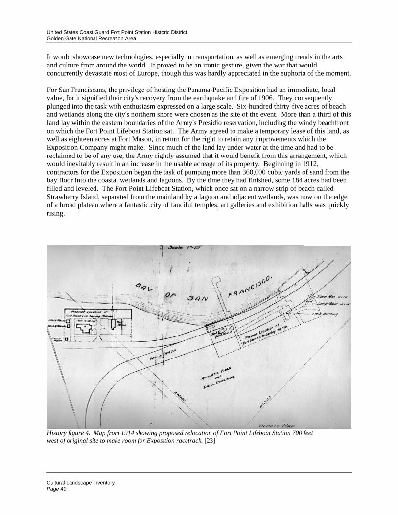
United States Coast Guard Fort Point Station Historic District Golden Gate National Recreation Area
Cultural Landscape Inventory Page 40
It would showcase new technologies, especially in transportation, as well as emerging trends in the arts and culture from around the world. It proved to be an ironic gesture, given the war that would concurrently devastate most of Europe, though this was hardly appreciated in the euphoria of the moment. For San Franciscans, the privilege of hosting the Panama-Pacific Exposition had an immediate, local value, for it signified their city's recovery from the earthquake and fire of 1906. They consequently plunged into the task with enthusiasm expressed on a large scale. Six-hundred thirty-five acres of beach and wetlands along the city's northern shore were chosen as the site of the event. More than a third of this land lay within the eastern boundaries of the Army's Presidio reservation, including the windy beachfront on which the Fort Point Lifeboat Station sat. The Army agreed to make a temporary lease of this land, as well as eighteen acres at Fort Mason, in return for the right to retain any improvements which the Exposition Company might make. Since much of the land lay under water at the time and had to be reclaimed to be of any use, the Army rightly assumed that it would benefit from this arrangement, which would inevitably result in an increase in the usable acreage of its property. Beginning in 1912, contractors for the Exposition began the task of pumping more than 360,000 cubic yards of sand from the bay floor into the coastal wetlands and lagoons. By the time they had finished, some 184 acres had been filled and leveled. The Fort Point Lifeboat Station, which once sat on a narrow strip of beach called Strawberry Island, separated from the mainland by a lagoon and adjacent wetlands, was now on the edge of a broad plateau where a fantastic city of fanciful temples, art galleries and exhibition halls was quickly rising.
History figure 4. Map from 1914 showing proposed relocation of Fort Point Lifeboat Station 700 feet west of original site to make room for Exposition racetrack. [23]

United States Coast Guard Fort Point Station Historic District Golden Gate National Recreation Area
Cultural Landscape Inventory Page 41
The relocated station became officially known as U.S.C.G. Fort Point Station No. 323. (The number would change to 310 sometime after 1920). The new location was the site of the current facility, and the present configuration of structures and landscaping was more or less established at that time. The chain of events which culminated in the station's move began in 1912, when contractors for the PPIE first began draining the lagoon behind Strawberry Island in order to make room for the exposition ground. In connection with this operation, it became necessary to install a sewer to drain the water displaced from the infilling back into the bay, and the most practical location for this drain passed through the lifeboat station. A series of correspondence documents the exposition committee's application to the Life-Saving Service for permission to construct this sewer. In addition, permission was sought to install a pump and associated piping to draw saltwater back up from the bay to sprinkle on the exposition grounds to keep down the dust. This apparatus would also be situated within the boundaries of the lifeboat station. The Life-Saving Service seemed amenable to these requests, which were relatively trivial, but by the end of that year, it appears that the exposition committee's desires had evolved into a much more serious demand. A letter from the assistant superintendent of the U.S. Revenue Cutter Service, dated January 8, 1913, summarized a request made to him by the Director of Buildings and Grounds of the Panama-Pacific International Exposition, a Mr. H.D. Connick, in which the latter expressed his desire to have the lifeboat station moved "...to a site several hundred feet westward of its present location." The Assistant Superintendent explained Mr. Connick’s concerns that,
...the present grounds interfere seriously with the race track, drill grounds and esplanade, as they butt directly against the eastern fence. [Mr. Connick] objects also to the appearance of the present station as being unsightly and not at all in harmony with the plans of the Exposition. By placing the station around the bend [of the race track] several hundred feet to the westward, it will clear the race track and esplanade, the latter running then directly in rear of the new station grounds. [24]
Despite the implied insult over the "unsightly" condition of its facility, the Life-Saving Service seemed willing to cooperate with the Exposition committee. The service realized that it might benefit from the move. This was due to the fact that the Fort Point Lifeboat Station really was in poor condition by that date and was sorely in need of upgrading. As noted already, the launchway had silted up and become unusable some years prior. Digging it out would provide only a temporary solution. A much longer structure was needed. The service also suspected that the present location of its facility contributed to the problem and that a more westerly location would be less inclined to silt up. But changing practices and the introduction of new technologies contributed more than anything else to the original lifeboat station’s obsolescence. The larger motor lifeboats which had been introduced several years earlier required a more robust launchway in order to support their increased weight. They also took up considerably more space and required a larger boathouse for storage and maintenance. The Life-Saving Service had also increased the complement of its lifeboat stations and now required year-round staffing. The original Keeper's Quarters had been designed to accommodate only seven part-time staff in addition to the keeper and his family. It was no longer large enough. The Exposition committee's request to move the Fort Point station provided a convenient excuse to initiate the necessary upgrading. More importantly, it offered the opportunity to have at least part of the upgrading paid for. By July of 1914, Sumner Kimball, General Superintendent of the Life-Saving Service, had expressed his assent to the proposed move, provided the government would incur none of the expense and that the new facility met LSS standards. In order to ensure the latter, the district superintendent of construction, Andre Fourchy, was asked to draw up plans and specifications for the proposed new facility. These were prepared in stages during the latter half of 1914. Preliminary specifications were ready by the middle of May, while complete engineering plans and elevations were not finished until November (Supplemental Information: Fourchy Plan). These documents, and associated correspondence, provide a detailed
United States Coast Guard Fort Point Station Historic District Golden Gate National Recreation Area
Cultural Landscape Inventory Page 42
baseline description of the Fort Point Lifeboat Station as it was initially constructed at the beginning of the period of significance. [25] Fourchy's completed drawings show how he intended the new facility to appear. His plans included a new, two-story boathouse, measuring 55 by 55 feet. This would include dormitory-style accommodations for 12 crew members plus a private room for the No. 1 Surfman (or Chief Petty Officer, as he became known under the Coast Guard system). The Keeper (or Officer-in-Charge, as he became known) would have the entire Officer-in-Charge Quarters for himself and his family. This change in use was reflected in Fourchy's plans by the elimination of the large kitchen extension, which would not be needed in a single-family residence. This extension and the enclosed rear porch were both replaced by a simple shed addition which would extend about three-quarters the length of the building and end with a door and steps on its south side. The older wooden launchway was replaced by a more robust structure with marine railway supported on steel piers, or bents. It was nearly twice the length of the original launchway. A survey made in 1975 (just prior to its demolition) described it as follows: "Marine railway and westerly catwalk: rails on fifty-one 13” wide cast iron pile bents spaced 7-1/2' O.C. [on center] = 382' long, 3' wide wood catwalk on wood piling spaced 12' o.c..." [26] Fourchy also proposed building two maintenance sheds just east of the top of the marine railway. One of these would accommodate a spur line for moving boats in need of repair off the main launchway track. The remaining auxiliary buildings were clustered on the west side of the facility, just beyond the O-in-C Quarters. They included a fuel house, garage, the water tower, and a hen house. These smaller structures were arranged to either side of a broad lane leading in from Marina Drive, and formed a small plaza between them in front of the hen house. A drill ground would be created on the seaward side of the O-in-C Quarters by building a wooden bulkhead, or seawall, about 150 feet beyond the mean high water line, then backfilling the protected space with sand topped with a 6-inch layer of macadam. This wooden bulkhead was understood to be a temporary measure, and the Life-Saving Service intended to replace it later with a more permanent concrete structure. (This was not done until sometime around 1935). The drill ground would extend lengthwise from the marine railway on the east to just beyond the cluster of auxiliary buildings on the west, a distance of about 250 feet. The wreck pole would be installed on the western end. The old boathouse does not appear at all in this plan, and presumably Fourchy was going to have it demolished. Fourchy's plans were followed closely—but not exactly, and parts of his design had to be realized in stages. The most significant deviation from plan was caused by the Exposition's refusal to commit itself to building any new structures except the marine railway. Thus, Fourchy's most important proposed structure, the new boathouse/crew's dormitory, was not completed until the end of 1915, after construction was undertaken by the Coast Guard itself. The Exposition agreed to assume responsibility for the following actions only:
1. Erection of a wooden bulkhead around the seaward side of the new facility. 2. Laying of 2-inch water mains from city water supply. 3. Backfilling and grading of surface behind bulkhead. 4. Transportation of original buildings to new site. 5. Construction of new steel launchway with marine railway. 6. Grading of walks. 7. Landscaping.
This list also suggests the order in which each action was taken. Instead of building a new boathouse, the Exposition engineers laid out the footprint of the proposed structure but placed the original boathouse in its place, with the new launchway attached. The rest of the old buildings were also preserved and laid out more or less in keeping with Fourchy's 1914 plan. The O-in-C Quarters stood about 90 feet west of the

United States Coast Guard Fort Point Station Historic District Golden Gate National Recreation Area
Cultural Landscape Inventory Page 43
boathouse and were oriented so that the front porch now faced east toward the boathouse, rather than north toward the bay. A small plaza was created between the buildings and the flagstaff was placed in the middle of it. Interior remodeling of the O-in-C Quarters was not undertaken as Fourchy proposed, since the building still had to serve as dormitory and headquarters for the entire crew. Auxiliary buildings were placed west of the O-in-C Quarters along with the water tower. The proposed maintenance sheds were not built until after the new boathouse was completed (and then only one, not two, was constructed). Landscape plantings were probably introduced at this time but no evidence exists to establish this for certain. The present configuration of driveways and footpaths was established more or less as it exists today. The Exposition planners may have had something to do with the orientation of the buildings in Fourchy's design, since the facility was to host open-house demonstrations and exhibits throughout the year. As a result, the Exposition planners wanted the boathouse to be readily accessible to the public while preserving privacy for the residential quarters. This may explain why the orientation of the two buildings was reversed. By February of 1915 all of these actions were complete, and the new facility was operational. A photograph (history figure 5) of the opening of the 1915 Grand Prix auto race, the event for which the Exposition's wooden racetrack was built, shows the Fort Point Coast Guard Station in the background. [26] The race was held on February 27, one week after the Exposition opened, so work on the relocated Coast Guard Station must have only just been completed. The old boathouse can clearly be seen occupying the space intended for Fourchy's larger boathouse. The Exposition's large garbage incinerator is visible in the background to the west of the station. Like most of the Exposition structures, this building would have been demolished or removed shortly after the event closed, probably sometime in 1916. Its presence helps confirm the date of another photograph taken sometime later in which the new boathouse appears. This demonstrates that the new boathouse was completed within a year of the station's relocation. This same photograph shows that a few other deviations from Fourchy's 1914 plan also occurred. Rather than build a new structure for a proposed garage at the west side of the facility, the original boathouse was moved to the center of the western driveway and reoriented so that its main boat doors opened to the south onto Marina Drive. It now became the garage for the O-in-C Quarters. This configuration eliminated the small plaza which had been proposed in Fourchy's plan. The water tower was placed directly behind the old boathouse, and just beyond it was a fuel shed. This was probably the old 16 by 24-foot storage shed which had been moved from the original site by the Exposition. The hen house proposed in Fourchy's plan can be seen just west of the water tower. The smaller lamp room was either never relocated or had been demolished by this date. Despite the completion of the new boathouse and dormitory, the O-in-C Quarters were not immediately remodeled. The large kitchen extension appears in photographs as late as 1926 and probably remained until about 1932. Photographs from the early 1920s show other minor deviations from the Fourchy plan. Just east of the marine railway, for instance, a single, large maintenance shed was built instead of the two smaller ones proposed. This building was a simple gable-roofed structure oriented with its major axis perpendicular to the shoreline. [28] The proposed spur from the launchway to this shed was never built. Another minor deviation was the location of the wreck pole. The smaller of the two original poles was retained in 1915 as Fourchy intended, but it was installed on the beach outside the western boundary of the seawall rather than within it. This may have been done to increase the amount of space available for drilling with the beach apparatus. Inadequate practice space would always be a problem for the Fort Point crew after they were confined to their new location.

United States Coast Guard Fort Point Station Historic District Golden Gate National Recreation Area
Cultural Landscape Inventory Page 44
History figure 5. Photograph of start of Grand Prix on February 27, 1915. Fort Point Coast Guard Station in its new location is visible in background. The new boathouse has not yet been built. The exposition incinerator is just visible in the upper left corner. [29]
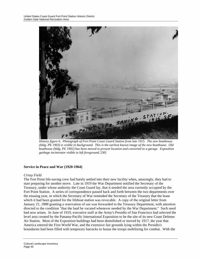
United States Coast Guard Fort Point Station Historic District Golden Gate National Recreation Area
Cultural Landscape Inventory Page 45
History figure 6. Photograph of Fort Point Coast Guard Station from late 1915. The new boathouse (bldg. PE 1903) is visible in background. This is the earliest known image of the new boathouse. Old boathouse (bldg. PE 1902) has been moved to present location and converted to a garage. Exposition garbage incinerator visible in left foreground. [30]
Service in Peace and War (1920-1964) Crissy Field The Fort Point life-saving crew had barely settled into their new facility when, amazingly, they had to start preparing for another move. Late in 1919 the War Department notified the Secretary of the Treasury, under whose authority the Coast Guard lay, that it needed the area currently occupied by the Fort Point Station. A series of correspondence passed back and forth between the two departments over the ensuing year, in which the Secretary of War reminded the Secretary of the Treasury that the lease which it had been granted for the lifeboat station was revocable. A copy of the original letter from January 21, 1888 granting a reservation of use was forwarded to the Treasury Department, with attention directed to the condition "that the land be vacated whenever needed by the War Department." Such need had now arisen. In June of 1919, executive staff at the Army's Presidio of San Francisco had selected the level area created by the Panama-Pacific International Exposition to be the site of its new Coast Defense Air Station. Most of the Exposition buildings had been demolished or moved by 1917, the year that America entered the First World War, and the extensive fair grounds lying within the Presidio's boundaries had been filled with temporary barracks to house the troops mobilizing for combat. With the

United States Coast Guard Fort Point Station Historic District Golden Gate National Recreation Area
Cultural Landscape Inventory Page 46
war's end, the Army now wanted to demolish these structures and create an airfield in their place. The Army included the Coast Guard Station in its demolition plans. It was feared that, were the buildings to remain in their existing location, aviators would be placed at risk trying to maneuver around them during take-off and landing. The Secretary of the Treasury agreed to the War Department's request. In return, it asked for permission to occupy a new site about a mile further east near Presidio Wharf. The Army agreed to the request and offered to lease lands at Presidio Wharf under essentially the same terms as before. But the move never occurred. The Coast Guard was unable to pay for the move's expense, and the War Department was unwilling to do so. On June 24, 1921, the completed Air Coast Defense Station was opened. The airstrip was named Crissy Field, in honor of an Army aviator who had been killed in a test flight. And the Fort Point Coast Guard Station remained where it was—beside the dirt runway. Between the Wars A routine-inspection report of the Fort Point Coast Guard Station in 1934 offers a detailed view into life at the facility. The inspector's report revealed that many of the routines established during the old Life-Saving Service remained the same under the Coast Guard. [31] The surfmen were drilled in boat handling, use of the beach apparatus, signals, and first aid. In addition, however, the surfmen were also drilled in fire fighting and infantry practice, including the use of firearms, which were now regularly kept at the station. The latter was a decided departure from the old Life-Saving Service but was consistent with the Coast Guard's role as a reserve military force. The Coast Guard's charter stipulated that it would "operate as a part of the Navy, subject to the orders of the Secretary of the Navy, in time of war or when the President shall so direct." [32] This provision had already been invoked once during the First World War. Even though the Coast Guard reverted to its pre-existing status under the Treasury Department at the end of hostilities, its close collaboration with the Navy during those two years had transformed the character of the Coast Guard and permanently introduced a variety of military practices and duties. Lifeboat facilities like the Fort Point Station which were situated in or around major harbors were responsible for patrolling these harbors in the event of hostile activity. Fort Point Coast Guard Station in effect became part of San Francisco's coastal defense. The station's crew now had to balance the dual responsibilities of life saver and coastal picketman. This compounding of duties is illustrated by the types of boat which were kept at the station. In addition to a motor lifeboat and self-bailing surfboat, the inspector's report from 1934 also mentions a cabin picket boat. As the name implies, this type of vessel was used for patrol work and would not have been part of the usual complement of a Coast Guard station prior to World War I. [33]

United States Coast Guard Fort Point Station Historic District Golden Gate National Recreation Area
Cultural Landscape Inventory Page 47
History figure 7. Aerial photograph from about 1938. This view corresponds closely with the site plan drawn up that year. Note that old boathouse (PE 1902) has not yet been aligned with buildings PE 1901 and PE 1903. Maintenance shop (PE 1907) at head of marine railway shows original north-south orientation of roof. [34]
The interbellum was a relatively stable period for the Fort Point Coast Guard Station. Following its reconstruction in 1915 at the present location, only minor changes were made to the facility until after World War II. Sometime between 1924 and 1926 the hen house and water tower were removed. By 1926 a basic landscaping scheme was also introduced, the rudiments of which still survive. This included a grass lawn surrounding the Boathouse and the O-in-C Quarters, a cypress hedge along Marina Drive, and a row of palm trees just inside this hedge (the palm trees can be seen in photographs from as early as 1922). The most significant structural changes occurred sometime between 1932 and 1935, when the front porch of the Boathouse was enclosed. The O-in-C Quarters were probably modified at this time as well. A detailed site plan made in 1938 indicates that the old kitchen has finally been removed and the building remodeled according to the plan proposed by Andre Fourchy in 1914. [35] The center rear dormer was also extended so that it is flush with the outer wall of the shed below it. The 1938 plan shows a number of other modifications which occurred sometime between 1926 and 1938. During this period the wooden seawall was replaced with the present concrete wall. The flagpole was moved to the middle of the driveway in front of the O-in-C Quarters again (this is where it stood in 1915). And two small garages were added just west of the old boathouse. World War II Operations In 1942, when the United States entered World War II, the Coast Guard was transferred to the Navy Department as it had been during the First World War. Fort Point Coast Guard Station assumed responsibility for harbor security in San Francisco Bay, in addition to its usual life-saving duties. At least three 38 foot cabin picket boats were kept at the station to patrol the local waters. One such picket boat had been part of the station's complement since at least 1934.

United States Coast Guard Fort Point Station Historic District Golden Gate National Recreation Area
Cultural Landscape Inventory Page 48
A number of modifications were made to the Coast Guard Station during the war. These can be seen in photographs from the period. The flagpole was moved once more from the plaza in front of the O-in-C Quarters to the seawall, and the widening of the driveway indicated in the 1938 plan has been removed so that the curbing is now straight again. A sign made of steel poles was erected over the entrance to this driveway. The flagpole was apparently moved in order to allow autos to pass along the driveway from Marina Drive to the interior of the facility, where as many as fifty vehicles were now stored on the old drill field just seaward of the O-in-C Quarters. Obviously the wreck pole which still stood on the west side of the drill field was not being used at this time. Perhaps a change in duty responsibilities made practice with the beach apparatus no longer necessary or possible. Additional parking was also available in a small lot on the east side of the boathouse just beyond the seawall. A Quonset hut was erected on the east side of this lot, and just beyond that were tennis courts surrounded by tall cyclone fencing. Towards the end of the war—perhaps in 1945 or 1946—the porch on the east side of the boathouse was enclosed. Post-War Consolidations In 1952 the Coast Guard requested permission from the Army to extend its Fort Point facility by 150 feet on its eastern side. [36] It wanted this additional space for a proposed "equipment and shop building." In a letter from January of that year the Coast Guard's 12th district commander explained that the recent closures of Point Bonita and Golden Gate Park Lifeboat Stations placed a greater burden on the remaining Fort Point Station and therefore required an expansion of its facilities. (The Point Bonita Station had closed in 1946; the Golden Gate Park Station in 1951). This request (which was granted) demonstrates how dramatically the Coast Guard was consolidating its resources in the years immediately following the war. The Fort Point station was by this time the only life-saving station in the San Francisco Bay Area south of Point Reyes. [37] A photograph from a few years later shows that a small, gable-roofed shed had been built just east of the older maintenance shop. The remainder of the area was being used for parking. Another, larger shed had been built on the World War II-era tennis courts, and the cyclone fence around these courts had been removed. These modifications are further illustrated in a Site Plan prepared in 1957. [38] On this plan the smaller shed is labeled "Paint Locker" and the larger structure "Storage Building." The old drill field on the seaward side of the O-in-C Quarters was apparently still being used for parking. The wreck pole has been truncated and moved southeast several feet closer to the garage. It was now being used to support a gooseneck outdoor lamp. The steel pole sign that stood over the entry drive during the 1940s has been replaced with a wooden post and lintel version.

United States Coast Guard Fort Point Station Historic District Golden Gate National Recreation Area
Cultural Landscape Inventory Page 49
History figure 8. Aerial view from north ca. 1958. [39]
Decline of the Fort Point Lifeboat Station (1964-present) New Technologies and a Changing Mission In 1963 the Coast Guard introduced a new 44-foot, steel-hulled motor lifeboat. Its first operational model, number CG-44300, entered service in October of that year at the Yaquina Bay Station in Oregon. The new vessel was more than just ten feet longer. It represented a dramatic modernization of lifeboat design and technology. It also represented profound consequences for the Fort Point station. [40] To begin with, the new boat would not fit on the marine railway and so had to be kept in the water more or less permanently. It was secured on mooring lines between the end of the boat dock and pilings—called "dolphins"—which stood just east of the dock. The marine railway ceased to be used from this date forward and was left to deteriorate. It was gradually disassembled over the ensuing years, the last of it being removed sometime shortly after 1978. Another consequence of the new boat was longer in coming but would eventually result in the Coast Guard abandoning its Fort Point station altogether. Since the boats had to be left in the water, they were vulnerable to the weather and to the strong tidal surge which ran through the bay near Fort Point. Boarding the boats was also complicated and frequently dangerous. Crew members had to climb down to the deck on the mooring line, supporting themselves precariously on ropes. Mishaps were common, and a great deal of equipment had to be recovered from the floor of the bay (providing the life savers with plenty of diving experience). [41] How the boats were raised from the water when they needed to be serviced is not clear now that the marine railway was out of service. The boats may have been taken to a different facility. The smaller surfboat was now lowered from davits attached to the edge of the boat dock just west of the buoy shack.

United States Coast Guard Fort Point Station Historic District Golden Gate National Recreation Area
Cultural Landscape Inventory Page 50
As the inconvenience of this situation became increasingly apparent, the Coast Guard began to search for a new location for its lifeboat facility. In August of 1970 the Fort Point Station was briefly deactivated and its operations transferred to the San Francisco Coast Guard Station on Yerba Buena Island in the middle of San Francisco Bay. The new location was better protected and more convenient for the life-saving crews, but added forty-five minutes to any response near the entrance of the bay, which is where most incidents occurred. The Fort Point crews left Yerba Buena Island less than two weeks later and reactivated the old station. But the final demise of the Fort Point Station was only a matter of time. Early the following year the Coast Guard began experimenting with a new type of boat technology. In January of 1971 two Air Cushion Vehicles (ACVs) were introduced to the Fort Point Station for a trial service. A metal hangar with a concrete launch apron was built just east of the boathouse. The ACVs traveled slightly above the surface of the water on a cushion of compressed air generated by downward-facing rotors. They were very fast—capable of 75 miles per hour—but they were also very expensive. When the pilot program's financing expired in June of 1973, it was not renewed. The Coast Guard preferred to invest its money in helicopters, which cost about the same as an ACV but had fewer operational limitations. At this time the Fort Point Station had a full complement of nearly thirty personnel. An Installation Report from 1972 lists twenty-seven enlisted personnel, one officer-in-charge, one civilian temporary hire and three dependents (at least one of whom must have been the officer-in-charge's wife). This was twice the number of personnel who staffed the facility in 1934. Much of this increase probably occurred shortly after the war, when the Fort Point Station assumed responsibilities that had once been shared between four other stations. [42] The old facility was simply not able to house the increased number of personnel. By the seventies, it was noted that most of the staff had homes elsewhere and commuted to the station. This relieved the burden on the living accommodations but created a greater need for parking. In 1972 a new parking lot was constructed on vacant land just west of the station boundary to provide sixteen additional spaces for Coast Guard personnel. Construction included asphalt paving over about one foot of red rock fill with a cyclone perimeter fence surrounding the entire lot. No retaining wall was built on the beach side of the project, and apparently the fill simply sloped down to the natural contour of the beach. This parking lot was immediately protested by the San Francisco Bay Conservation and Development Commission. The commission was concerned about a number of issues in addition to the fact that it had not been consulted. These included the environmental effects of construction on the beach shoreline, the aesthetic and environmental effects of debris left in the parking lot, and restriction of public access to the beach. Apparently, these 250 yards of polluted shoreline represented one of the only public access beaches on San Francisco Bay in 1972 and had become popular among local residents. The Coast Guard commanding officer mollified public sentiment by having his personnel clean up the garbage from the area and by continuing to allow public access to the beach. The parking lot, however, remained. [43] In 1974 the Coast Guard began making plans to remove the remainder of the now badly-deteriorated marine railway. It notified the State Historic Preservation Officer (SHPO) of its intent. The SHPO responded with a letter approving of the Coast Guard's proposed action, offering its opinion that the action would have no adverse effect on the site, but it instructed the Coast Guard to prepare a formal "determination of no adverse effect" and forward this to the Advisory Council on Historic Preservation (ACHP) in Washington, D.C. This was promptly done, and the ACHP concurred with the Coast Guard's determination in September of that year. While this decision may seem surprising in light of how integral the marine railway was to the historic function and character of the Fort Point Coast Guard Station, it is important to note how deteriorated the railway was by 1974. Its condition was noted in a survey made the following year:

United States Coast Guard Fort Point Station Historic District Golden Gate National Recreation Area
Cultural Landscape Inventory Page 51
The marine railway has not been used for over 15 years. It is in an advanced state of deterioration. All that is left of the railway itself are the pile bents. Only the easterly catwalk, which is in fair condition, is still required as access to the search and rescue boat dock. [44]
History figure 9. Photograph of deteriorated marine railway in 1978 shortly before its complete demolition. Photograph taken by Gordon Chappell—PWR Historian. [45]
By 1978, the Coast Guard had still done nothing with the marine railway. In an apparent excess of caution, it once more requested advice from the State Historic Preservation Officer. This second request may have seemed necessary, because the Coast Guard was now proposing further modifications in addition to just the removal of the railway. These would include:
1. Removal of remaining marine railway structure and adjacent catwalk. 2. Remodeling of boathouse in order to provide living space for as many as thirty personnel. The most significant feature of this proposed remodel was the conversion of the first-floor boat room into eight double-occupancy bedrooms. This required removing all three boat doors on the north side as well as the supply door on the west and filling in these spaces with solid walls. New partitions were to be built on the interior. 3. Removal of ACV hangar and construction of additional parking in its place. 4. Removal of World War II-era shop. 5. Rehabilitation of buoy shack at end of boat pier.
This time, the Coast Guard also consulted the National Park Service, and an historian from that agency visited the site that year. [46] The Park Service endorsed all of the Coast Guard's proposed treatments but recommended that the boathouse modifications be done in such a way as to be reversible. This would require preserving and storing the large boat doors once they were removed and building new walls

United States Coast Guard Fort Point Station Historic District Golden Gate National Recreation Area
Cultural Landscape Inventory Page 52
between existing load-bearing piers. Whether these recommendations were followed is not known. All proposed actions except number 4—removal of the World War II-era shop—were eventually carried out. [47]
History figure 10. Photograph of main boat doors with detail, taken in 1978 shortly before their removal. Photograph taken by Gordon Chappell—PWR Historian. [48]
History figure 11. Photograph of beach apparatus door with detail, taken in 1978 shortly before its removal. Photograph taken by Gordon Chappell—PWR Historian. [49]
Shipwrecks and Assistance III In 1980 the wreck of the two ocean-going barges Kona and Agattu illustrates some of the dramatic changes which had been introduced into Coast Guard practice by this date. Kona and Agattu were massive, welded-steel barges that were designed to be towed by tugboat between San Francisco and Hawaii. Just minutes before midnight on New Year's Eve, 1979, as the ocean-going tug Sentinel was pulling Kona and Agattu out of the Golden Gate enroute for the Hawaiian islands, the towline on the Kona parted, and the hapless barge drifted out of control toward the rocks just north of Point Bonita, where it finally wrecked. Since the Kona was carrying primarily lumber and paper products, there was little danger—either to humans or the environment—from the detritus of its misfortune. Less than an hour after the Kona's demise, however, the Agattu's towline snagged in Sentinel's screw and was severed. Like the Kona, the Agattu now drifted to shore and wrecked on Cronkhite Beach. But unlike the Kona, the Agattu was carrying potentially dangerous cargo. It had thirty-five cylinders of chlorine gas, which, if ruptured, could produce a lethal cloud large enough to envelop much of the Bay Area. The Coast Guard

United States Coast Guard Fort Point Station Historic District Golden Gate National Recreation Area
Cultural Landscape Inventory Page 53
responded to the threat with helicopters, which successfully transported all of the chlorine gas cylinders to shore. The success of this operation demonstrates the profound changes wrought on Coast Guard operations with the introduction of aircraft, especially helicopters. Lifeboats continued to be used, but their operations would now be coordinated with those of helicopters and fixed-wing aircraft. Although the number of commercial shipping disasters declined precipitously during the twentieth century as improved ship-board technology and aids to navigation made it much easier to avoid potential hazards, the possibility of disaster remains. This was dramatically illustrated in 1984 when the 34,000 ton supertanker Puerto Rican exploded just outside the Golden Gate. The cause of the explosion remains unknown. The tanker was loaded to capacity when the disaster occurred, and it burned for twenty-four hours before Coast Guard crews could finally subdue the flames. By this time the ship had split in two. The rear section sank, leaking its cargo of oil into the Gulf of the Farallones for years afterward. The forward section was stabilized and brought back to port, where its vitreous cargo could be removed. The magnitude of this wreck, as well as concern over the environmental consequences of its spilled cargo, indicate some of the changing priorities faced by the Coast Guard in more recent times. When the Hanalei wrecked on Duxbury Reef in 1914, the Life-Saving Service attributed its success in recovering at least some of the victims to the oil slick which calmed the roiling waters. It even suggested applying oil at future wrecks to facilitate rescue efforts. When the Puerto Rican went down, the chief concern was for containing the oil leaked by the vessel and mitigating its environmental consequences. The Denouement In 1983 the Coast Guard undertook renovations of the O-in-C Quarters and grounds. Although an Army memo from August 2, 1984 notes that the "Coast Guard has made rather substantial expenditures to renovate the Station and the Officer's-In-Charge Quarters," the full extent of this work seems to have been relatively minor. It included upgrading of the electrical system in the quarters and the addition of a picket fence and new entry way on the south side at Marina Drive. These renovations were documented in a site plan made just prior to their introduction. [50] The following year the Coast Guard proposed building a new breakwater and boat pier, which were expected to be completed about 1987. These projects were never undertaken. Instead, the Coast Guard deactivated its Fort Point Station in 1990 and moved all operations to a new facility located on Horseshoe Cove at East Fort Baker on the north side of the bay. This facility remains active at the present date (2006). In 1962 the Presidio of San Francisco was established as a National Historic Landmark and in 1993, in anticipation of the Presidio’s military deactivation, the NPS conducted a large-scale effort to update the NHL. This update provided detailed lists of contributing and non-contributing features. Most of the historic structures within the Fort Point Coast Guard Station were determined to contribute to this landmark, but the station’s unique history and landscape characteristics were not fully documented or made clear at that time. In 1995, the Fort Point station reverted to the National Park Service after the Army transferred the Presidio. Currently most of the grounds and structures are used for offices and classrooms by the NOAA under an Interagency Agreement and Use Permit, renewable at five-year intervals. As of this writing—2006—NOAA is undergoing master planning efforts for the facility. _______________________ Physical History Endnotes 1 In fact, Congress authorized "any suitable number of public vessels, adapted to the purpose," to patrol during the winter storm season. But since only the Revenue Marine's cutters were "adapted to the purpose" only they

United States Coast Guard Fort Point Station Historic District Golden Gate National Recreation Area
Cultural Landscape Inventory Page 54
conducted these patrols. See Robert Johnson, Guardians of the Sea: The United States Coast Guard, 1915 to the Present. (Annapolis, MD: Naval Institute Press, 1987), 4. 2 In 1863 the Revenue Marine became the Revenue Cutter Service. 3 To call the volunteers "untrained" might by unduly harsh, since most of these men were fishermen by trade and usually very competent with a small boat in local waters. The two greatest problems with the volunteer system were ensuring regular maintenance of the facilities and gathering a volunteer crew quickly enough during an emergency. 4 Quoted in William Wallace Johnson, “The United States Life-Saving Service,” The New England Magazine 8.2 (Apr., 1890): 135. 5 Martha J. Lamb. "The American Life-Saving Service." Harper's New Monthly Magazine 64.381 (February, 1882): 361; and Dennis Noble. That Others Might Live: The U.S. Life-Saving Service, 1878-1915. (Annapolis, MD: Naval Institute Press, 1994), 81-90. 6 Gebhard, David Gebhard and David Bricker. The Former U.S. Coast Guard Lifeboat Rescue Station and Lookout Tower, Point Arguello, California (1936-1941). (Heritage Conservation and Recreation Service, Interagency Archeological Services, 1980), 8. 7 A comprehensive study of this subject was made by Eugene York in 1983. See his "The Architecture of the United States Life-Saving Stations." Master of Arts thesis, Boston University 1983. 8 The Point Bonita Life-Saving Station, built in 1899 and deactivated in 1946. 9 The low-lying region adjacent to the eastern border of the Presidio is still known as Cow Hollow. It derived its name from the number of small dairy ranches that operated in the vicinity. 10 GOGA park files, National Park Service, Pacific West Regional Office, Oakland, California. 11 From a description given by Sumner Kimball in official correspondence to Andre Fourchy, Superintendent of Construction, 13th Life-Saving District, San Francisco, CA, dated May 7, 1914. National Park Service, Golden Gate NRA, Park Archives and Records Center (PARC), GOGA-3088, F1/2. 12 Reproduced from Erwin N. Thompson, Defender of the Gate: The Presidio of San Francisco, A History from 1846 to 1995 (San Francisco, CA: National Park Service, 1997), 820. Original owned by San Francisco Public Library. Print available at Golden Gate NRA, Park Archives and Records Center (PARC). Permission of SFPL required if published. 13 The yellow fir mentioned by the contractor was probably Douglas fir (Pseudotsuga menziesii). 14 This winch was part of the original equipment requisitions made in 1890. Its presence, however, does not prove the existence of a marine railway at that date, since it could have been used to move boats on the earlier-style wheeled carriages, which did not utilize rails. 15 National Park Service, Golden Gate NRA, Park Archives and Records Center (PARC), GOGA-2265, Folder 2 (OS). 16 Reproduced from Thompson, Defender of the Gate, 821. Original owned by San Francisco Public Library. Print available at Golden Gate NRA, Park Archives and Records Center (PARC). Permission of SFPL required if published. 17 Quoted in Report of the United States Life-Saving Service, for the Fiscal Year Ended June 30, 1891. (Washington, D.C.: Government Printing Office, 1892), 76. 18 This account is not a complete record of incidents to which the Fort Point crews responded. Only a few of the station's more illustrative and noteworthy activities are here described. 19 Annual Report of the United States Life-Saving Service, for the Fiscal Year Ended June 30, 1911. (Washington, D.C.: Government Printing Office, 1912), 21. 20 Annual Report of the United States Life-Saving Service, for the Fiscal Year Ended June 30, 1912. (Washington, D.C.: Government Printing Office, 1913), 88. 21 The City of Rio de Janeiro, a passenger steamer of the Pacific Mail Steamship Co. (like the City of New York), struck rocks off Point Lobos in a heavy fog early on the morning of February 22, 1901. Since the vessel sank in less than ten minutes, there was no chance of a rescue attempt, and so the incident is not mentioned in relation to the Fort Point Lifeboat Station. The first who learned of the accident were the fishermen who were just then sailing out of the bay at the start of their day's labor. These boats were responsible for picking up the only survivors of the stricken passenger liner. 128 of a total 210 passengers and crew were lost on the City of Rio de Janeiro. Most of them never made it to the deck before the ship went down. 22 It is unfortunate for the Hanalei that the Bolinas Bay Lifeboat Station was no longer in service. It had been deactivated in 1885 after the facility burned down. (Keeper George Gibson was suspected of arson). Had the

United States Coast Guard Fort Point Station Historic District Golden Gate National Recreation Area
Cultural Landscape Inventory Page 55
Bolinas station still been active, a more rapid response might have resulted in the rescue of all the passengers and crew on board the Hanalei. 23 National Park Service, Golden Gate NRA, Park Archives and Records Center (PARC), GOGA-3088, folder 1/2. 24 Official Correspondence, Assistant Inspector, U.S. Revenue Cutter Service to General Superintendent, U.S. Life-Saving Service, January 8, 1913. National Park Service, Golden Gate NRA, Park Archives and Records Center (PARC), GOGA-3088, folder 1/2. 25 Full-scale plans available at Golden Gate NRA, Park Archives and Records Center, GOGA-2265, folder 2. 26 Proceedings of a Board of Survey, June 24, 1975; Survey No. 12-277-75; USCG Records, Real Property Branch, 12th CG District, Alameda, CA. 27 Since the Life-Saving Service had now become the U.S. Coast Guard, the station will be referred to by its new name from here on. 28 The structure presently on this site is oriented with its major axis parallel to the shore. 29 Reproduced from Stephen A. Haller, The Last Word in Airfields: San Francisco's Crissy Field (San Francisco: Golden Gate National Parks Association, 2001), 12. Original available at Golden Gate NRA, Park Archives and Records Center (PARC), GOGA-1766 (OS). 30 National Park Service, Golden Gate NRA, Park Archives and Records Center (PARC), GOGA-2042. 31 Official Correspondence. Chief Boatswain Alfred Rimer to Inspector, Western Area, August 21, 1934. National Park Service, GOGA Park Files, Pacific West Regional Office, Oakland, California. 32 "An Act to Create the Coast Guard," quoted in Robert Erwin Johnson, Guardians of the Sea: History of the United States Coast Guard, 1915 to the Present. (Annapolis, MD: Naval Institute Press, 1987), 44. 33 The boats mentioned were type "T" 36-foot motor lifeboat No. 3676, 36-foot cabin picket boat CG-2357, and 26-foot self-bailing surfboat No. 4515. Another self-bailing surfboat (No. 1345) was in poor condition and used only for practice. The station also possessed a pulling dory (No. 4401) and a 9-foot pulling dinghy (No. 2733). The inspector may have been in error in recording the length of the cabin picket boat as 36 feet. The standard picket boat used by the Coast Guard during the thirties and forties was a 38-foot model which had been introduced in 1931. It is also possible that the boat described by the inspector was an earlier version. 34 National Park Service, Golden Gate NRA, Park Archives and Records Center (PARC). 35 Ground Layout of the Fort Point Coast Guard Station. August 24, 1938. National Park Service, Golden Gate NRA, Park Archives and Records Center (PARC). Detailed plans of the entire facility were drawn up in 1932. These include floorplans of the O-in-C Quarters showing the described renovations. These plans may have been done in association with the actual work. See PARC, GOGA-3088, Folder 2 (OS). 36 Official Correspondence, Commander, 12th CG District, to Commanding General, Sixth Army, Presidio of San Francisco, Calif., January 2, 1952. USCG Records, Real Property Branch, 12th CG District, Alameda, CA. 37 The Point Reyes Coast Guard Station, located in Drakes Bay, would close in 1968. 38 Site Plan & Vicinity Map, May 16, 1957. National Park Service, Golden Gate NRA, Park Archives and Records Center (PARC). 39 National Park Service, Golden Gate NRA, Park Archives and Records Center (PARC). 40 The exact date of introduction at the Fort Point Station is not known. Photographs from February of 1964 show the old 36-foot series TRS lifeboats still in service. The first of the 44s probably arrived later that year but were certainly in service at Fort Point no later than 1965. 41 Dale Champion, "Army, Park Service Squabble Over Fort Point." San Francisco Chronicle, June 2, 1986. 42 Southside, which reverted back to the War Department in 1945; Point Bonita, which closed in 1946; Golden Gate Park, which closed in 1951; and Point Reyes, which closed in 1968. 43 For summary of dispute from a public point-of-view, see Alan Cline, "Auto Rules on Scenic Beach," in The San Francisco Sunday Examiner and Chronicle, January 21, 1973. 44 Proceedings of a Board of Survey, June 24, 1975; Survey No. 12-277-75; USCG Records, Real Property Branch, 12th CG District, Alameda, CA. 45 Photograph by Gordon Chappell, 1978. National Park Service, Golden Gate NRA Park Files, Pacific West Regional Office, Oakland, California. 46 The historian was Gordon Chappell. See "Memorandum to Regional Director, Western Region" on "Meeting with U.S. Coast Guard representatives at Fort Point Station and Point Bonita Lighthouse...," April 19, 1978. National Park Service, Golden Gate NRA Park Files, Pacific West Regional Office, Oakland, California. 47 Memorandum to Regional Director, Western Region, from Acting Chief, Division of Cultural Resource Management, Western Region, April 19, 1978. National Park Service, Golden Gate NRA Park Files, Pacific West

United States Coast Guard Fort Point Station Historic District Golden Gate National Recreation Area
Cultural Landscape Inventory Page 56
Regional Office, Oakland, California. The ACV hangar was not removed until after 1998 by the National Park Service. 48 Photographs by Gordon Chappell, 1978. National Park Service, Golden Gate NRA Park Files, Pacific West Regional Office, Oakland, California. 49 Ibid. 50 Rehabilitation of O-in-C Qtrs., Fort Point Station, May 6, 1983. U.S. Coast Guard, 12th District, Alameda, CA, Civil Engineering. Full-scale copies of engineer's drawings of all renovations are available at Golden Gate NRA, Park Archives and Records Center (PARC).