status of airborne oblique imaging eurosdr …
TRANSCRIPT

STATUS OF AIRBORNE OBLIQUE IMAGING EUROSDR COMMISSION I PROJECT “OBLIQUE IMAGERY” Markus Gerke May 15, 2014

THE FIRST AIRBORNE PHOTOS …WERE OBLIQUE
First recorded aerial photograph in the US (Boston),
by James Wallace Black, 1860, source Wikipedia

Intuitively the operator shot from a slanted angle
Recognition of buildings In the 1930’s: USGS and
military systematically captured oblique images
THE FIRST AIRBORNE PHOTOS …WERE OBLIQUE
First recorded aerial photograph in the US (Boston),
by James Wallace Black, 1860, source Wikipedia
Fairchild T3-A camera, source
Petrie (2009)

1. Brief overview
2. EuroSDR questionnaire on the current status of oblique airborne imagery
3. Conclusions and Outlook
CONTENT

1. Brief overview
2. EuroSDR questionnaire on the current status of oblique airborne imagery
3. Conclusions and Outlook
CONTENT

Vertical/nadir images: good observation of ground features and roof structures, assume constant scale Oblique images: observation of vertical structures, but occlusion more dominant, varying scale
PROPERTIES SCENE OBSERVATION

PROPERTIES SCALE
According to Shufelt (1999): Vertical images: t < 5° Low oblique: 5°< t <30° High oblique: t > 30° If (t+α) > 90°: horizon visible For mapping purpose: concentration on high oblique images which do not include the horizon
(symbols from Höhle (2008))

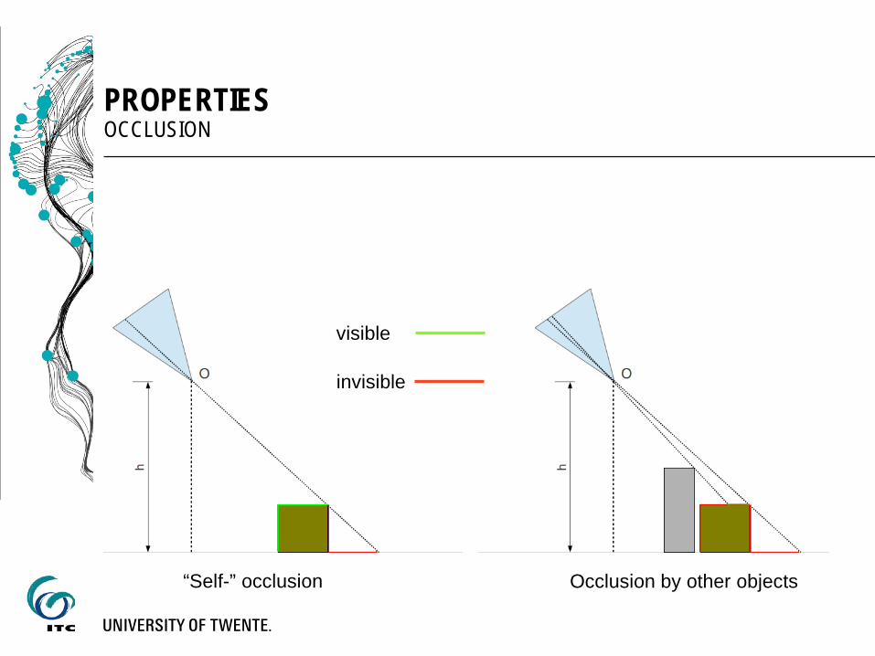
PROPERTIES OCCLUSION
“Self-” occlusion
visible
invisible
PROPERTIES OCCLUSION
“Self-” occlusion Occlusion by other objects
visible
invisible

Mitigation through multiple view and overlap
PROPERTIES OCCLUSION
visible
invisible
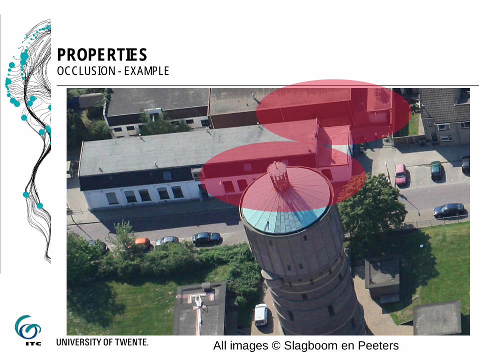
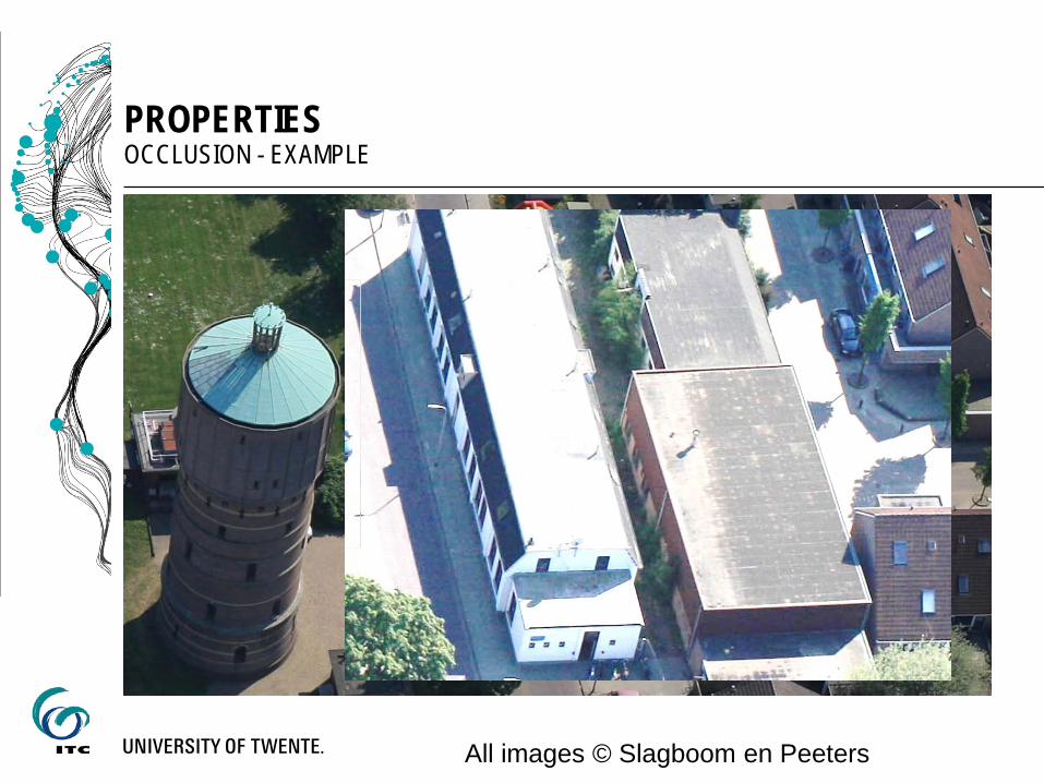
PROPERTIES OCCLUSION - EXAMPLE
All images © Slagboom en Peeters
All images © Slagboom en Peeters

All images © Slagboom en Peeters
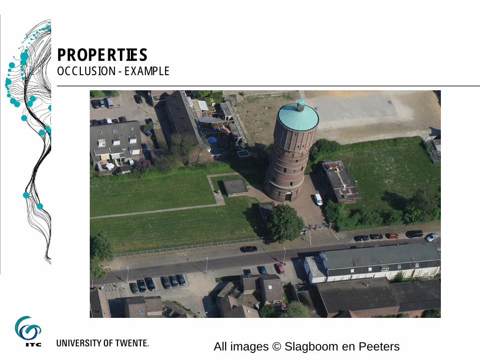
PROPERTIES OCCLUSION - EXAMPLE
All images © Slagboom en Peeters
PROPERTIES OCCLUSION - EXAMPLE
All images © Slagboom en Peeters
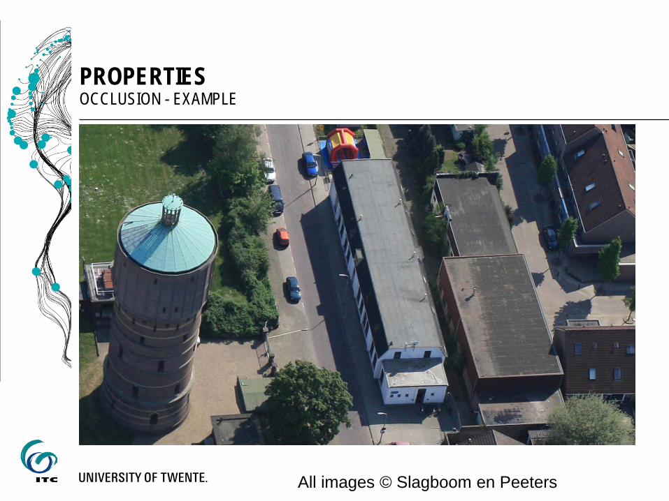
PROPERTIES OCCLUSION - EXAMPLE
All images © Slagboom en Peeters
PROPERTIES OCCLUSION - EXAMPLE
All images © Slagboom en Peeters

PROPERTIES MALTESE CROSS CONFIGURATION
Source: Petrie, 2009
IGI Penta DigiCAM, Source: Homepage IGI
Maltese Cross configuration: one vertically pointing camera and 4 highly obliques pointing to the four cardinal directions. Used mainly for visualisation and (urban) data interpretation.

PROPERTIES MALTESE CROSS CONFIGURATION
Leica Oblique 5-camera head, source homepage Leica
Maltese Cross configuration: one vertically pointing camera and 4 highly obliques pointing to the four cardinal directions. Used mainly for visualisation and (urban) data interpretation. Companies offering such systems, eg: Track‘Air MIDAS Modular mid format systems IGI Penta DigiCam (RGB or CIR) Hexagon/Leica 5 camera head, mid format camera RCD30. RGB (plus
optional NIR in all cameras) Microsoft Osprey 5 camera head, NIR only in nadir See also January to May 2014 issues of the GIM international magazine for an overview

1. Brief overview
2. EuroSDR questionnaire on the current status of oblique airborne imagery
3. Conclusions and Outlook
CONTENT

CURRENT STATUS OF OBLIQUE AIRBORNE IMAGERY EUROSDR QUSTIONNAIRE
Motivation of users/producers/sellers etc to buy or produce oblique airborne images not fully analyzed yet
1st step of the EuroSDR project on obliques: create an online survey Put online end March 2014 Today: presentation of (preliminary) analysis, selection

CURRENT STATUS OF OBLIQUE AIRBORNE IMAGERY EUROSDR QUSTIONNAIRE
Motivation of users/producers/sellers etc to buy or produce oblique airborne images not fully analyzed yet
1st step of the EuroSDR project on obliques: create an online survey Put online end March 2014 Today: presentation of (preliminary) analysis, selection Key figures of the survey: Separation user of images /software or hardware vendor About 10questions As of 9 May 2014: 127 participants

CURRENT STATUS OF OBLIQUE AIRBORNE IMAGERY EUROSDR QUSTIONNAIRE, AS OF 9 MAY 2014
127 participants, 59 from academia, 24 NMA, 15 companies
0%
5%
10%
15%
20%
25%
30%
35%
40%
45%
50%

CURRENT STATUS OF OBLIQUE AIRBORNE IMAGERY EUROSDR QUSTIONNAIRE, AS OF 9 MAY 2014
Usage of oblique airborne images
0%
10%
20%
30%
40%
50%
60%
70%
80%
USERSVENDORS

CURRENT STATUS OF OBLIQUE AIRBORNE IMAGERY EUROSDR QUSTIONNAIRE, AS OF 9 MAY 2014
Usage of oblique airborne images (end users, vs. producer)
0%10%20%30%40%50%60%70%80%

0%
10%
20%
30%
40%
50%
60%
70%
80%
USERSVENDORS
CURRENT STATUS OF OBLIQUE AIRBORNE IMAGERY EUROSDR QUSTIONNAIRE, AS OF 9 MAY 2014
Usage of oblique airborne images (end users, vs. producer)
• Good agreement • Users see texturing less important than vendors • identification / mapping tasks in focus of users • other usages listed by participants
• Geological hazard assessment (rockfall, landslide...) • wetland mapping, habitat mapping, forest mapping

CURRENT STATUS OF OBLIQUE AIRBORNE IMAGERY EUROSDR QUSTIONNAIRE, AS OF 9 MAY 2014
What can obliques do better? (only asked to users)
0%
10%
20%
30%
40%
50%
60%
70%
80%
easier identificationof objects
increase degree ofautomation
increase reliability do what is notpossible today

CURRENT STATUS OF OBLIQUE AIRBORNE IMAGERY EUROSDR QUSTIONNAIRE, AS OF 9 MAY 2014
What can obliques do better? (only asked to users)
0%
10%
20%
30%
40%
50%
60%
70%
80%
easier identificationof objects
increase degree ofautomation
increase reliability do what is notpossible today
Interesting comments (apart from what we know already) • Identifying the heights of the features like trees, buildings
and etc. while editing automatically generated DSM for producing DTM.
• Collect multiview datasets, eg for BDRF measurements • Complement SAR for urban imaging • Rock surface analysis • Model/measure roof overhang

CURRENT STATUS OF OBLIQUE AIRBORNE IMAGERY EUROSDR QUSTIONNAIRE, AS OF 9 MAY 2014
Vendors we asked: In which sense would the tasks mentioned benefit if oblique images were used?
Answers (selection): • different view on the subject which is valuable for interpretation. • exact measurements as for mapping updates do not gain from
obliques, ad-hoc measurements however do. • proper textures for city modelling • Geomarketing, 3D-modeling, urban-planning • better geometrical 3D modelling of all imaged objects • intuitive visualization, 3D effect without 3D real geometry • information about the number of floors

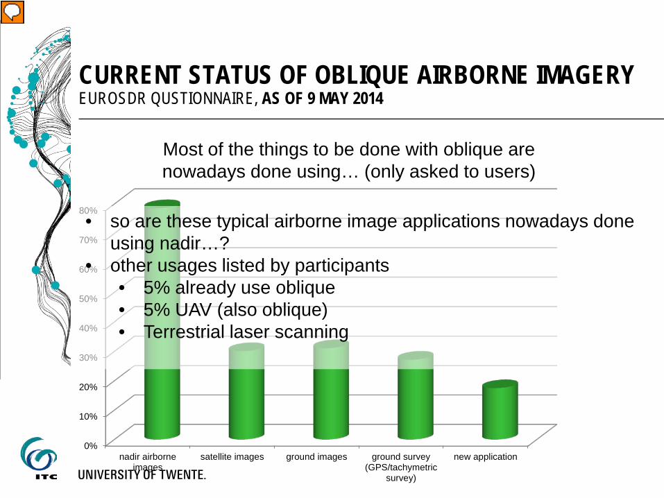
CURRENT STATUS OF OBLIQUE AIRBORNE IMAGERY EUROSDR QUSTIONNAIRE, AS OF 9 MAY 2014
Most of the things to be done with oblique are nowadays done using… (only asked to users)
0%
10%
20%
30%
40%
50%
60%
70%
80%
nadir airborneimages
satellite images ground images ground survey(GPS/tachymetric
survey)
new application
0%
10%
20%
30%
40%
50%
60%
70%
80%
nadir airborneimages
satellite images ground images ground survey(GPS/tachymetric
survey)
new application
CURRENT STATUS OF OBLIQUE AIRBORNE IMAGERY EUROSDR QUSTIONNAIRE, AS OF 9 MAY 2014
Most of the things to be done with oblique are nowadays done using… (only asked to users)
• so are these typical airborne image applications nowadays done using nadir…?
• other usages listed by participants • 5% already use oblique • 5% UAV (also oblique) • Terrestrial laser scanning
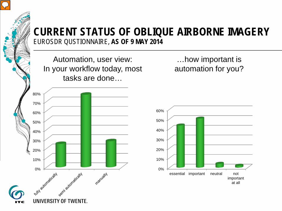
CURRENT STATUS OF OBLIQUE AIRBORNE IMAGERY EUROSDR QUSTIONNAIRE, AS OF 9 MAY 2014
Automation, user view: In your workflow today, most
tasks are done…
0%
10%
20%
30%
40%
50%
60%
70%
80%
…how important is automation for you?
0%
10%
20%
30%
40%
50%
60%
essential important neutral notimportant
at all

CURRENT STATUS OF OBLIQUE AIRBORNE IMAGERY EUROSDR QUSTIONNAIRE, AS OF 9 MAY 2014
Automation, user view: In your workflow today, most
tasks are done…
0%
10%
20%
30%
40%
50%
60%
70%
80%
…how important is automation for you?
0%
10%
20%
30%
40%
50%
60%
essential important neutral notimportant
at all
From comments we see: • initial data processing (orientation, dense matching)
seems to work fully automatically (depending on software, size of block, some say it does not work)
• interpretation still the bottleneck. Differentiation between • “simple” (identification of buildings etc) (realistic to do
automatically) • much more complex, detailed modeling of complex
buildings (should still be done manually, unrealistic do let this be done automatically)

CURRENT STATUS OF OBLIQUE AIRBORNE IMAGERY EUROSDR QUSTIONNAIRE, AS OF 9 MAY 2014
Importance of compatibility to in-house software?
0%
5%
10%
15%
20%
25%
30%
35%
40%
essential important neutral notimportant
at all
Experience with oblique processing software: how do
you rate it?
0%
5%
10%
15%
20%
25%
30%
35%
40%
Still some homework to do by vendors

CURRENT STATUS OF OBLIQUE AIRBORNE IMAGERY EUROSDR QUSTIONNAIRE, AS OF 9 MAY 2014
GSD and stereo overlap
0
20
40
60
80
100
120
1 7 13 19 25 31 37 43 49 55 61 67 73 79 85 91 97 103
109
115
121
127
maximum allowed GSD at image centre (cm)
Mean 19cm, but majority in the 10cm range or less
0%5%
10%15%20%25%30%35%40%45%50%
at least 60%overlap (i.e.
stereo)
at least 70% at least 80%
But not answered by 45 participants (35%) so do they not need stereo?

CURRENT STATUS OF OBLIQUE AIRBORNE IMAGERY EUROSDR QUSTIONNAIRE, AS OF 9 MAY 2014
Near Infrared: would you need NIR for your application?
0%
10%
20%
30%
40%
50%
60%
Yes, in all viewingdirections
Yes, but in nadir view issufficient
No, not at all
CURRENT STATUS OF OBLIQUE AIRBORNE IMAGERY EUROSDR QUSTIONNAIRE, AS OF 9 MAY 2014
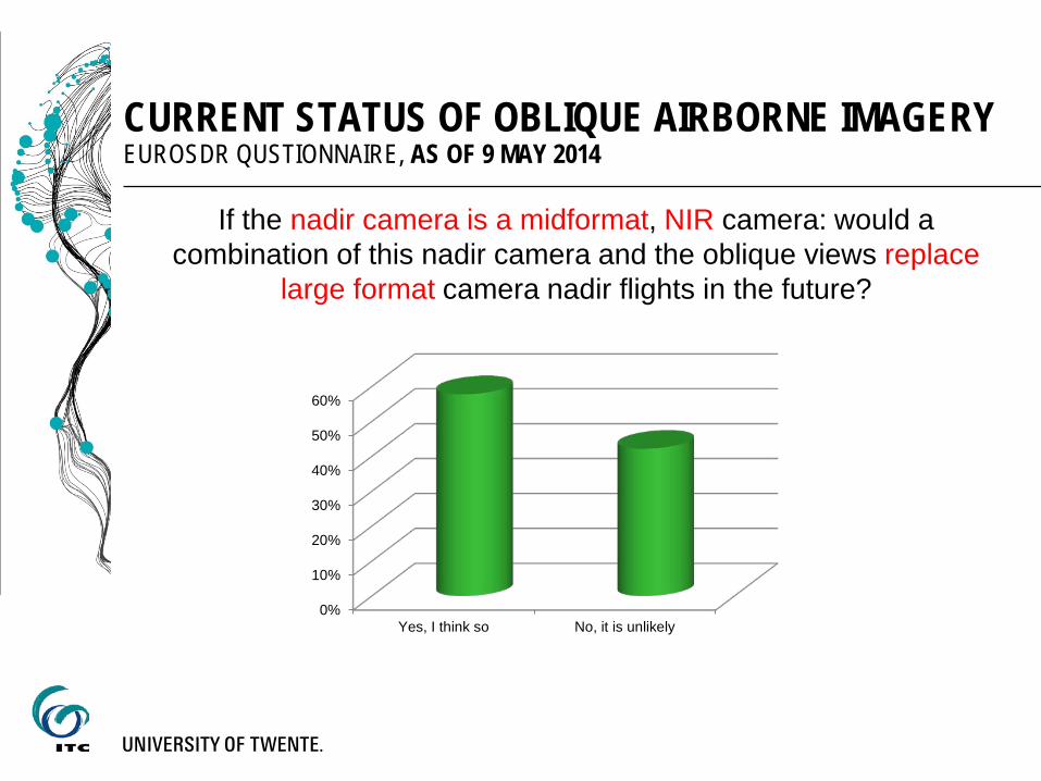
If the nadir camera is a midformat, NIR camera: would a combination of this nadir camera and the oblique views replace
large format camera nadir flights in the future?
0%
10%
20%
30%
40%
50%
60%
Yes, I think so No, it is unlikely

CURRENT STATUS OF OBLIQUE AIRBORNE IMAGERY EUROSDR QUSTIONNAIRE, AS OF 9 MAY 2014
If the nadir camera is a midformat, NIR camera: would a combination of this nadir camera and the oblique views replace
large format camera nadir flights in the future?
0%
10%
20%
30%
40%
50%
60%
Yes, I think so No, it is unlikely
Some comments • Yes, first of all in urban areas (3D photo realistic instead of 2.5D
mapping) it is possible, in non-urban still only nadir preferred • Yes, because obliques will increase reliability and accuracy of
products • No, because too much data for normal projects • No, because oblique will not replace high-res orthoimages
• It depends on the products requested on the market (comment
from company…)

CURRENT STATUS OF OBLIQUE AIRBORNE IMAGERY EUROSDR QUSTIONNAIRE, AS OF 9 MAY 2014
One last issue…
UAV pops up again and again… link oblique and nadir on small areas, very high resolution
CURRENT STATUS OF OBLIQUE AIRBORNE IMAGERY EUROSDR QUSTIONNAIRE, AS OF 9 MAY 2014
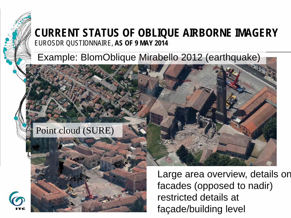
Example: BlomOblique Mirabello 2012 (earthquake)
Large area overview, details on facades (opposed to nadir) restricted details at façade/building level
Point cloud (SURE)

CURRENT STATUS OF OBLIQUE AIRBORNE IMAGERY EUROSDR QUSTIONNAIRE, AS OF 9 MAY 2014
Example: UAV Mirabello 2012 (earthquake)
Small area only, but details at façade/building level, access unsafe areas
Point cloud (PMVS2)
1. Brief overview
2. EuroSDR questionnaire on the current status of oblique airborne imagery
3. Conclusions and Outlook
CONTENT

CONCLUSIONS
Systematically captured airborne oblique images have reached the market
Big players jump on and offer systems Some findings from the questionnaire (so far?)
Views from users and vendors coincide quite nicely, users have more ideas of what to do with the images
At least in urban areas a replacement of large format images by advanced 5-camera systems, including NIR seems possible
Users see relation manned/unmanned oblique image acquisition Homework for software vendors (researchers!): Orientation of big blocks Automation of interpretation

OUTLOOK
Next step within the EuroSDR commission I – project Cooperation within the ISPRS Scientific Initiative A new benchmark dataset for multi-platform very high resolution photogrammetry (Nex, Gerke, Remondino) Objectives/Challenges for researcher/vendors/everyone interested To be benchmarked: (joint) orientation of multi-platform imagery dense image matching of (fused) datasets Other things you can do Building detection/update, City modeling, eg CityGML, texturing,
interpretation, vegetation,…., BRDF (restricted)

OUTLOOK
Next step within the EuroSDR commission I – project Cooperation within the ISPRS Scientific Initiative A new benchmark dataset for multi-platform very high resolution photogrammetry (Nex, Gerke, Remondino) (To be) captured in Dortmund: IGI PentaCam-flight by AeroWest (80/80%), GSD 10cm UAV flights in selected areas (oblique/nadir) Terrestrial images in selected areas Reference data: static GNSS, TLS, Totalstation City centre: 1300, open museum 900 airborne images

OUTLOOK
Next step within the EuroSDR commission I – project Cooperation within the ISPRS Scientific Initiative A new benchmark dataset for multi-platform very high resolution photogrammetry (Nex, Gerke, Remondino) (To be) captured in Dortmund: IGI PentaCam-flight (80/80%), GSD 10cm UAV flights in selected areas (oblique/nadir) Terrestrial images in selected areas Reference data: static GNSS, TLS, Totalstation City centre: 1300, open museum 900 airborne images

OUTLOOK
Next step within the EuroSDR commission I – project EuroSDR-specific questions could easily be linked to that ISPRS project. We appreciate any ideas and suggestions!

Thank you for your attention. Questions?