steens mountain wilderness · steens mountain wilderness monitoring indicators. indicator 1:...
TRANSCRIPT

STEENS MOUNTAIN WILDERNESS
MONITORING PLAN
Bureau of Land ManagementOregon
Burns DistrictSteens Mountain Cooperative Management and Protection Area

STEENS MOUNTAIN WILDERNESS MONITORING PLAN
Table of Contents:
SECTION I: VISITOR USE MONITORING
1. Monitoring plan summary.2. Monitoring plan indicators.3. Campsite monitoring form.4. Campsite monitoring form instructions.5. Trail monitoring form.6. Trail monitoring form instructions.7. Occupied campsite form.8. Encounters form.9. Trails register form.10. Winter Recreation monitoring form.11. Motor vehicle monitoring form.
SECTION II: ECOSYSTEM MONITORING

STEENS MOUNTAIN WILDERNESSMONITORING PLAN SUMMARY
GOALS:
1. To establish and maintain a wilderness recreational impacts monitoring system, gatheringbaseline data that will assist with future planning by monitoring seven indicators: campsitecondition, campsite density, perception of solitude, trail condition, length of visitor stay,recreational stock use, and motor vehicle intrusions.
2. To evaluate the current condition of the resource in relation to management objectives in orderto identify any problems.
3. To recognize trends and to evaluate the effectiveness of management programs in relation towilderness use.
OBJECTIVES:
1. To locate, inventory, and document wilderness campsites.2. To document the condition of wilderness campsites.3. To evaluate campsite density per management area.4. To evaluate wilderness solitude by the closeness of wilderness campsites to each other and by
monitoring the number of inter-party wilderness encounters.5. To determine the average length of visitor stay in the wilderness.6. To establish the impact, or lack thereof, of recreational stock use on each backcountry campsite.7. To evaluate change in width and trail depth and to analyze and document multiple trailing on
established wilderness trails and campsite social trails.8. To monitor the effects of winter recreation within the Wilderness.9. To monitor for motor vehicle intrusions into the Wilderness.
PROCEDURES:
1. Campsites in Big Indian Gorge, Little Blitzen Gorge, Wildhorse and Little Wildhorse Gorges,Little Indian Gorge, Pike Creek Canyon, Cold Springs Canyon, Mud and Ankle Creeks and theDonner und Blitzen River will be monitored. Each site will be assigned a rating of minimum,moderate, high or extreme impact according to an modified Cole monitoring form. Camps willbe plotted on maps. The wilderness will continue to be surveyed for additional campsites. Theexception is at Wildhorse Lake where camping is only allowed at two established anddesignated campsites. Any sign of other campsites within Wildhorse Lake basin should bereported, dismantled and naturalized immediately. Also, any sign of campsites at LittleWildhorse Lake will be eliminated.
2. Recreational stock use and impacts on campsites will be recorded on a campsite inventoryform.
3. Parties discovered camped within sight or sound of each other will be documented on anoccupied campsite form to evaluate degree of wilderness crowding and opportunities forsolitude. Any comments made by visitors from the trailhead registration pages should be usedin conjunction with the compiled ranger data.
4. Inter-party wilderness encounters, on and off trail will be documented and monitored using awilderness encounter form to evaluate degree of wilderness crowding and opportunities forsolitude. Comments made by visitors from the trailhead registration pages should be used inconjunction with the compiled ranger data.
5. Trail counter data (to be installed 2004) will be used in conjunction with completed visitorregistration forms and ranger field observations to determine wilderness recreation usenumbers.
6. Average length of visitor stay will be monitored by tallying information on trailheadregistrations at Big Indian, Little Blitzen, Wildhorse Lake, Pike Creek and the Donner undBlitzen River.

7. Trail width, depth and multiple trailing will be monitored on established wilderness trails andwill be recorded on a trail monitoring form. Established trails include Big Indian, Little Blitzen,Wildhorse Lake, Pike Creek, Mud/Ankle Creek, and the Donner und Blitzen River trail. Arandom number table was used to determine the points where the trail monitoring should bedone. The numbers 1, 2, 4 and 7 were chosen from the random number table to reflect theapproximate mile points where the trail monitoring would occur. At these points, a GPS readingwill be taken and the monitoring conducted at these points. The exceptions are the Donner undBlitzen River trail where the trail is not seven miles long so only miles one, two and four willbe used. Pike Creek trail is less than four miles long, so miles one and two will be used. On theWildhorse Lake trail, the monitoring will be done along the steep upper slope and on the lower,flat meadow area.
8. A winter use recreation monitoring form will be completed by BLM personnel after eachmonitoring trip into the winter recreation use area. The monitoring will include user activityand will also document any intrusions into the wilderness which will be noted as violations.The winter use recreation area is defined as “from the snowline on the North Loop Road to theKiger Gorge overlook”.
9. A winter recreation use registration box will be installed along the North Loop Road uponclosure of the road for the winter season to estimate use of ‘walk up’ visitors and those who donot wish to acquire a winter use permit. This data will also be used in conjunction with rangerfield observations to evaluate degree of wilderness crowding and opportunities for solitude.This box should be retrieved at the end of the winter recreation season.
10. A wilderness motor vehicle intrusion monitoring form will be completed by BLM personnelafter any observation of motor vehicle use and intrusion into the Wilderness from any road.Such monitoring will be year-long, including winter months. The monitoring will include useractivity and will also document any intrusions into the wilderness which will be noted asviolations. The category of ‘motor vehicle’ will include, but not be limited to, off-highwayvehicles (OHV) and snowmobiles.
FREQUENCY:
1. Campsite inventories will be completed twice during the season, using the campsite inventoryform.
2. Big Indian, Little Blitzen, Pike Creek, Donner und Blitzen River, Wildhorse Canyons, ColdSprings, Little Indian, Little Wildhorse, and Kiger Canyons and Mud and Ankle Creeks will bemonitored twice – once in early summer and once in early fall. Other locations may be added ifdeemed necessary.
3. Recreational stock use and impacts will be monitored twice a year with the regular campsiteinventory.
4. The occupied campsite form will be filled out whenever anyone camping in the wilderness isencountered, including the monitoring personnel.
5. The wilderness encounter form will be filled out every day spent in the wilderness, regardless ifsomeone is encountered or not.
6. Visitor trailhead registration sheets will be collected when a page becomes full, or nearly full.This is to ensure that pages are not stolen or defaced. This includes the winter use registrationbox.
7. Calibration of trail counters and the observation by rangers of visitor trailhead registrationboxes should be done to achieve better wilderness use numbers. Trail counter calibration shouldbe done once a month by either physically observing the number of people crossing over thecounter or by BLM personnel walking over the counter a number of times and verifying thenumber of crosses with the counter. Registration boxes should be observed for a minimum of 4hours a day twice a month to help determine visitor registration rates. In both cases, calibrationshould be done with the ranger out of view of the visitors.
8. The established GPS points on the trails will be monitored at the beginning and end of everysummer season.
9. Winter recreation use will be monitored on the North Loop Road to the Kiger overlook, assnow conditions and personnel allow and preferably twice a month. The Nye Cabin Road andDingle Creek Road will be monitored if use by snowmobiles has been observed.

10. Monitoring of motorized vehicle use intrusions into the wilderness will occur whenever suchintrusions are observed. Also, a strategy will be developed for patrolling for intrusions if suchlevels increase.
FILES:
Completed forms, photographs and maps will be kept in a file in the wilderness office. In addition, awilderness database will be created for ease of organization and retrieval of monitoring information.Data collected will be summarized annually, and compiled into a yearly monitoring report.

STEENS MOUNTAIN WILDERNESSMONITORING INDICATORS
Indicator 1: Campsite Condition
C Monitor using the campsite inventory form.C Monitored twice a year; once in early summer and again in early fall.C Take photos of each campsite at the beginning of the summer season to measure off-season
recovery rate and again in early fall to measure summer usage.C Campsite condition is defined as a human or recreational stock caused change in the land and is
measured by comparison with an adjacent plat of land.C Maintain a permanent file for each campsite in the wilderness office containing an updated
inventory form, photos and a detailed map of the campsite.C Attention should be paid to any changes in rating.C Document ratings and map campsites on a large campsite inventory map. Symbols should go
next to campsite number. Place a symbol next to the corresponding campsite number each yearto easily indicate a change in status. Symbols are as follows:
Red circle: minimum impactBlue triangle: moderate impactGreen square: heavy impactYellow star: extreme impactBlack rectangle: site has been naturalized and is being monitored
Indicator 2: Campsite Density
C Monitor density using the campsite inventory form as a guideline.C Measured per each management area, the Gorge and the Uplands.C A campsite is defined as an area of human flattened vegetation where it can be inferred that at
least one person camped or spent a considerable amount of time. C A campsite could have a fire ring, structures, etc…, but doesn’t have to in order to be labeled a
campsite.C All campsites found within the wilderness boundary should be inventoried, inspected,
documented, labeled and mapped on 7 ½ minute topographic maps. C When a campsite has been rehabilitated by natural or human means and has been monitored for
a period of three summer seasons without further use, it can be taken out of the system.C If an area was rehabilitated, then camped in again, the site will be put back in the system.C As new campsites are found, these should be inventoried, documented, and added to the
campsite map.C Once a year, preferably at the end of the summer season, the number of campsites per
management area will be counted and analyzed by monitoring personnel. Special attentionshould be given to the number of new campsites created and any change in campsite rating.
Indicator 3: Perception of Solitude
1. Number of other parties camped within sight or continuous sound per canyon or destination area (notincluding car camping on or near wilderness boundaries.)
C Monitor using the occupied campsite form and trailhead registration pages.C Campsites within sight or sound of each other are defined as two or more campsites situated
100 yards or less from each other.C Monitored whenever an occupied campsite is seen, including that of monitoring personnel,
within the wilderness boundary. This does not include car camping on wilderness boundaries oroff cherry stem roads.
C Document also if no campsites are seen within sight or sound of a particular camp.C If the same group previously monitored is seen on a different day, document them again as a
new entry.C Record a given camp only once a day.

C Visitor comments (i.e. “I camped next to a party of 8 on Tuesday”) can be used as reliablemonitoring information if their whole trip can be documented. This includes dates, camplocations, and the number of occupied campsites within sight or sound every night of their trip.
C Rangers should not go out of their way to camp near someone.C Completed forms will be filed and an analysis completed at the end of each summer season.
2. Number of wilderness encounters per day on or off trail, per canyon or area.
C Monitor using the wilderness encounter form.C An encounter is defined as a situation within the wilderness boundary when two or more
separate parties pass each other, talk to each other, or are close enough to hear each other. Thisincludes all areas except campgrounds.
C Count people viewed from a distance as an encounter.C Monitor number of encounters every day spent in the wilderness, along with specific location
and party size. If no one is encountered on a given day, this too should be documented.C Visitor comments (i.e. “There were 6 people at the headwall of the gorge yesterday”) can be
used as reliable monitoring information if their whole trip can be documented. This includesdates, camp locations and the number of encounters during their trip.
C Completed forms be filed and analysis completed at the end of each summer season.
Indicator 4: Trail Conditions
C Monitor trail width, trail depth, and multiple trailing of established wilderness and campsitesocial trails using a standard trail monitoring form.
C Established wilderness trails include Little Blitzen, Big Indian, Donner und Blitzen River, PikeCreek, and Wildhorse Lake. The Mud/Ankle Creek trail will be monitored in the future if andwhen ‘single track’ trail conditions exist.
C Monitor campsite social trails and map them on the campsite inventory form. C For established wilderness trails, use the established GPS points along each trail to be
monitored and continue to use these same points every year.C Monitor condition of established trails twice a year, once at the beginning of the summer season
and once at the end.C Monitor any newly discovered or created established trails similarly.
Indicator 5: Length of Stay
C Assess length of stay primarily by retrieval of visitor registration self sign in books attrailheads, as well as information gathered from wilderness ranger visitor contacts.
C Place visitor registration books at the following trailheads: Big Indian, Little Blitzen, Donnerund Blitzen River, Pike Creek, the South Steens equestrian campground, Mud/Ankle Creek andWildhorse Lake.
C Post a sign at each trailhead that explains why it is important to sign in.C Analyze information annually.
Indicator 6: Recreational Stock Use
C Monitor recreational stock use on a section of the campsite monitoring form.C Recreational stock impacts that will be assessed include root exposure of trees due to stock, tree
girdling and evidence of stock by the presence of feed and manure.C Analyze the relationship between frequent stock use and campsite impact ratings annually.C Evidence of cows, specifically manure, is not to be used as evidence of stock within the
campsite.
Indicator 7: Motor Vehicle Intrusions
C Monitor motorized vehicle intrusions into the wilderness on the motor vehicle intrusionsmonitoring form.

C Intrusions into the wilderness by any type of motor vehicle including, but not limited to, OHVsand snowmobiles will be assessed.
C Monitoring will occur year-round, including winter months, whenever intrusions are observed.C Analyze the need to restrict or discontinue motorized vehicle use in certain areas based on the
number of motor vehicle intrusions into the wilderness over the established time period.
BLM Burns District, OR020-8560-01(March 2004)
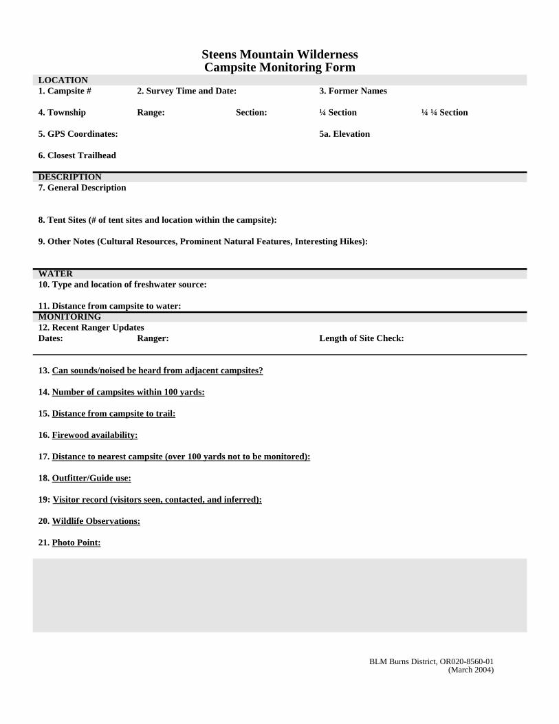
Steens Mountain WildernessCampsite Monitoring Form
LOCATION1. Campsite # 2. Survey Time and Date: 3. Former Names
4. Township Range: Section: ¼ Section ¼ ¼ Section
5. GPS Coordinates: 5a. Elevation
6. Closest Trailhead
DESCRIPTION7. General Description
8. Tent Sites (# of tent sites and location within the campsite):
9. Other Notes (Cultural Resources, Prominent Natural Features, Interesting Hikes):
WATER10. Type and location of freshwater source:
11. Distance from campsite to water:MONITORING12. Recent Ranger UpdatesDates: Ranger: Length of Site Check:
13. Can sounds/noised be heard from adjacent campsites?
14. Number of campsites within 100 yards:
15. Distance from campsite to trail:
16. Firewood availability:
17. Distance to nearest campsite (over 100 yards not to be monitored):
18. Outfitter/Guide use:
19: Visitor record (visitors seen, contacted, and inferred):
20. Wildlife Observations:
21. Photo Point:

BLM Burns District, OR020-8560-01(March 2004)
Steens Mountain WildernessCampsite Monitoring Form
22. MAP OF CAMPSITE (Draw a detailed map that includes measurements, compass directions, social trails, geologic andnatural features, tent site locations, and mineral soil exposure.

BLM Burns District, OR020-8560-01(March 2004)
Steens Mountain WildernessCampsite Monitoring Form (continued)
Inside Campsite Outside Campsite23. Vegetation Cover 0-5% 6-25% 26-50% 51-75%
76-100%0-5% 6-25% 26-50% 51-75% 76-100%
24. Mineral Soil Exposure 0-5% 6-25% 26-50% 51-75% 76-100%
0-5% 6-25% 26-50% 51-75% 76-100%
Human-causedratings
1 2 3 Impact Index
25. Vegetation Loss No difference incover
Difference of onecoverage class
Difference of two ormore coverage classes
x 2 =
26. Mineral Soil Increase
No difference incover
Difference of onecoverage class
Difference of two ormore coverage classes
x 3 =
27. Human Caused Tree Damage# of trees scarred =# of trees felled =
0-25% of alltrees in sitescarred or felledor have brokenlower branches
26-50% of all treesin site scarred orfelled or havebroken lowerbranches
More than 50% of alltrees in site scarred orfelled or have brokenlower branches
x 3 =
28. Development None 1-2 rock or logstructures
More than 2 structures x 1 =
29. Cleanliness
# of fire rings =
Litter?
No more thanevidence of fire.No fire ring orlitter.
One fire ring,some litter, oneburnt log or up to50% of rocks insite scarred
More than one firering, or a large amountof litter, or any sign ofhuman waste, orgreater than 50% ofrocks in site scarred, ormore than one burntlog
x 1 =
30. Social Trails # of trails =
No more thanone discernabletrail
Up to 3discernable trails
More than 3discernable trails
x 2 =
31.Camp Area = sq ft
0-500 sq. feet 501-1500 sq. feet More than 1500 sq.feet
x 3 =
Recreational StockRatings
1 2 3 Impact Index
32. Root Exposure 0-25% 26-50% More than 50% x 3 =33. Tree Girdling 0-1 tree girdled 2 to 3 trees girdled More than 3 trees
girdled x 3 =
34. Evidence of Recreational Stock
None Manure or feedonly
Manure, feed and/ortree damage present.
x 3 =
35. Minimum Impact 20 - 29 Moderate Impact 30 - 39 Heavy Impact 40 - 49 Extreme Impact 50+Total Impact Index Total =( include stock totals )
36. Minimum Impact 9 - 12 Moderate Impact 13 - 15 Heavy Impact 16 - 19 Extreme Impact 20+Total Impact Stock Total =

Steens Mountain WildernessCampsite Monitoring Form Instructions
A permanent file located in the wilderness office will be maintained that will contain campsite inventory forms, photos,and a map of the campsite. In addition, there should be a separate file for each area (see below #1) including a 7 ½ minutemap with all area campsites marked by GPS points. Campsites should be monitored twice a year, once at the beginningand once at the end of the summer season.
1) Campsite #: Record current campsite number. This is a three or four digit identifier unique to each campsite.The first two digits refer to a particular area or drainage and are as follows:
Wildhorse Lake: WHCold Springs Canyon: CSMud Creek: MCAnkle Creek: ACBig Indian: BILittle Blitzen: LBDonner und Blitzen River East: BREDonner und Blitzen River West: BRWPike Creek: PC
The third and forth numbers will be numbers that reflect the order in which the site was discovered. Other areaswill be added as needed.
2) Survey date: Enter the exact time and date the campsite was monitored. Record as DAY-MONTH-YEAR-TIME. Both are crucial in organizing field photos with a digital camera.
3) Former names: For comparison with past inventories, record any nicknames or former names. For newlydiscovered campsites, a name may be assigned if desired.
4) Township, range, section and quarter section: Fill in the correct grid information.
5) GPS coordinates: Enter coordinates. Take reading in the same place as the campsite photo.
6) Closest trailhead: Record the closest trailhead. Established trailheads include Big Indian, Wildhorse Lake, LittleBlitzen, Donner und Blitzen River, Mud/Ankle Creek, Pike Creek.
7) General description: Give a description of the campsite including size, impact, vegetation type and anything elseyou can think of.
8) Tent Sites: Enter the number of tent sites, condition of sites and general location of each site.
9) Other notes: Include information on cultural resources, natural features, nearby hikes, etc.
10) Freshwater sources: Record name of river, creek or drainage. Document up to two sources.
11) Distance from campsite to water: This is the distance in feet the campsite is from a perennial or annual river,spring, creek or lake. Measure the distance from the middle of the campsite.
12) Recent ranger updates: Include the date, your first and last name, and the length of time you spent monitoringthe campsite.
13) Sounds from adjacent campsites: Include any human or stock noises heard from any other nearby campsite.Record on the occupied campsite form.
14) Number of campsites within 100 yards: Record number and name of any campsite, regardless if the other site isoccupied by a camping party or not. Record on the occupied campsite form.
15) Distance from campsite to an established trail system: Measure the distance in feet from the nearest trail to thecampsite. If the nearest trail is miles away, round to the nearest tenth of a mile. Differentiate between anestablished trail and a social trail and measure from the middle of the campsite. Current established trail systemsinclude Donner und Blitzen River, Wildhorse Lake, Big Indian, Mud/Ankle Creek, Little Blitzen and Pike

Creek.
16) Firewood availability: Walk around the campsite and note the different types of possible firewood on theground. Record the nearest distance in feet from the center of the campsite to the closest available wood. Thisshould be enough to make a small fire for one night, approximately 2 cubic feet of varying sizes of wood,including kindling. Do not count already collected firewood. Also make note of the type of firewood availablein the area.
17) Distance to nearest campsite: This is meant to be a check for future seasons. Only monitor the distance up to 100yards. Anything over, just leave the section blank.
18) Outfitter/Guide use: Record encounters with guides as well as groups that are known to use the site.
19) Visitor record: Document number of visitors seen, contacted, and/or inferred at the campsite. Be sure to alsodocument on the occupied campsite and wilderness encounter forms.
20) Wildlife observations: Includes any wildlife sightings, big or small, furry or feathered observed at the campsite.Also include any intriguing tracks.
21) Photo point: Take photos at the same location where the GPS reading was taken, preferably the center of thesite. Take four photos at each site which point towards the four cardinal directions; north, east, south and west.
22) Campsite Map: Draw a detailed map of the campsite. Include measurements, compass directions, social trails,geologic features, locations of tent sites and any mineral soil exposure. Keep a permanent map of each campsitein each campsite file. Make a copy of the map and mark in pencil any changes to the campsite. The mapdrawing may be done only once per season.
23) Vegetative cover (Inside campsite): Study the ground on the inside of the campsite thoroughly. Speculate, onaverage, what percentage of the ground is covered by vegetation. Do not count trails going through camp. Docount satellite areas outside the site into the equation such as stock areas, tent pads, kitchen areas, etc. Circle 0-5%, 6-25%, 26-50%, 51-75%, or 76-100%.
Vegetative cover (Outside campsite): Study the ground at least 20 feet outside of the campsite thoroughly.Speculate, on average, what percentage of the ground is covered by vegetation. Circle 0-5%, 6-25%, 26-50%,51-75%, or 76-100%.
24) Mineral soil exposure (Inside campsite): Study the ground on the inside of the campsite thoroughly. Speculate,on average, what percentage of the ground has mineral soil exposed. Mineral soil is defined as bare soil with novegetation growing anywhere. If there are sprouts of any kind growing, then it does not count as mineral soil.Do not count trails going through camp. Do count satellite areas outside the site into the equation such as stockareas, tent pads, kitchen areas, etc. Circle the correct percent of mineral soil that is exposed; 0-5%, 6-25%, 26-50%, 51-75%, or 76-100%.
Mineral soil exposure (Outside campsite): Thoroughly study the ground at least 20 feet outside of the campsite.Speculate, on average, what percentage of the ground has mineral soil exposed. Circle the correct percent ofmineral soil exposed. Circle 0-5%, 6-25%, 26-50%, 51-75%, or 76-100%.
25) Root Exposure: Calculate the percentage of trees with roots exposed from human use. Do not count trees thathave naturally exposed roots. Count trees with damages roots before scarred trees. Do not count a tree for bothroot exposure and scarring. Find impact index.
26) Tree Girdling: Defined tree damage encircling the tree. Count tree girdling before scarring and root exposure.Do not count any girdled tree for root exposure and scarring. Find impact index.
27) Evidence of stock: Be sure that the evidence points to horse, mule, llama or other pack animal dung, not a wildanimal or cattle. Find impact index.
28) Vegetation loss: Take note of the difference in coverage classes from number 23, vegetation cover. Circle theappropriate box. Under the Impact index, multiply the rating number above the box you circled by the numberalready in the Impact index box. For example, if you recorded campsite vegetative cover was 50% inside the siteand 75% outside the site, this would be a difference of one coverage class with a rating of 2. You would thenmultiply the 2 by 2, for a total of 4.

29) Mineral soil increase: Take note of the difference in coverage classes from number 24, mineral soil exposure.Circle the appropriate box. Under the impact index, multiply the rating number above the box you circled by thenumber already in the impact index box. For example, if you recorded the average percentage of mineralexposed was 25% inside the site and 5% outside the campsite, this would be a difference of one coverage classwith a rating of 2. You would then multiply the 2 by 3, for a total of 6.
30) Tree damage: Record the number of trees scarred inside as well as immediately outside the campsite. Scarredtrees include anything nailed or inserted in a tree, or anything carved into a tree. One nail found in a tree countsas scarring. Girdling does not count, as there is a separate section for recreational stock use. Record number offelled trees within and immediately outside of the campsite. Calculate the percentage of scarred and/or felledtrees and circle the appropriate percentage. Multiply the rating by 3 to get the impact index.
31) Development: This counts as any human made structure and includes, but is not limited to rock chairs, alters,backrests, log benches, meat hangers, seats or tables. Circle the category and calculate the impact index.
32) Cleanliness: Count the number of fire rings and document whether or not litter is present. Count all fire ringsand sites of repeated fires, with or without rock rings. Faint scars or sites of one time use should not be counted.If there is more that one fire ring, a large amount of litter, more than one burnt log or any evidence of humanwaste, rating 3 should be circled and the impact index would be a 3.
33) Social Trails: Any trail, besides the main trail that leads from the site. These are side trails which provide accessto water, other sites, viewpoints, firewood, bathroom places, etc. Find impact index. Draw all social trails on themap drawn of each campsite.
34) Camp area: This is the total camp area in square feet measured by using a tape measure. Measure satellite areas(stock areas, tent pads, etc.) outside the site and add them to the total site size. Calculate the impact index.
35) Add up all of the impact indexes to find the total index. Designate impact by circling either minimum, moderate,heavy or extreme impact.
36) Add up the three stock indexes to find the total stock impact index. Designate impact by circling eitherminimum, moderate, heavy or extreme stock impact.

BLM Burns District, OR020-8560-02(March 2004)
Steens Mountain Wilderness Trail Monitoring Form
Date and Time________________
Name_______________________
Trail Name GPS Point Photo # Width Rating Depth Rating Multiple TrailsRating

Steens Mountain WildernessTrail Monitoring Form Instructions
A. Trail width:
1 = Slight. Trail widening is occurring > 24”, but is occurring in dry and sandy or upland soils with little impact tovegetation and little soil compaction. Trail is likely to become wider.
2 = Moderate. Trail widening is occurring 24” to 36”, and is occurring in an area of sensitive riparian vegetation,causing moderate damage to riparian vegetation and sod, some moderate soil erosion is occurring along dry areaswhere soil productivity is affected. Potential for increased damage likely.
3 = Severe. Trail widening > 36” within a wet riparian/meadow area or adjacent stream crossing causing significantdamage to sod and active erosion is occurring. Condition is in an active state and has a potential to become worse.
B. Trail depth:
1 = Slight. Slightly depressed trail is evident. Slight root exposure is noticeable.2 = Moderate. Tread depth shows active erosion and the trail is incising. Tread is less than 12 inches below ground
surface. Evidence of scour and sediment is leaving the trail and a moderate amount may be entering streamchannels where trail is adjacent to streams. Beginning stages of gullying is starting to form.
3 = Severe. Trail is actively eroding, gullies are present. Tread is greater than 12 inches below ground surface.Evidence of sediment transport into stream channels at crossings is apparent. Trail is in an eroded state anddifficult to tread.
C. Multiple trailing:
0 = None1 = Slight. Multiple trailing is occurring, though not in an advanced condition.2 = Moderate. Two to three trails have formed, some moderate damage has occurred to sod and riparian vegetation,
some erosion within the trial troughs. Condition is worsening.3 = Severe. Two to three trails have formed, have deeply incised troughs, loss of sod and damage to riparian
vegetation is occurring.

Burns BLM District, OR020-8560-03(March 2004)
Steens Mountain WildernessOCCUPIED CAMPSITE FORM
Perception of Solitude Indicator
Number of other parties camped within sight or continuous sound per canyon or destination area
Instructions: Record date, location of camp and number of other campsites within sight and/or sound for every occupied camp discovered in the wilderness,including your own. If no other camps are within sight or sound, this too must be documented.
DATE LOCATIONCAMPSITENUMBER
# OF CAMPS WITHIN SIGHTAND/OR SOUND COMMENTS

BLM Burns District, OR020-8560-04(March 2004)
Steens Mountain WildernessEncounters Form
Perception of Solitude Indicator
Document each encounter in the wilderness, on trail and off. If no one is encountered on a certain day, record the date and location, and leave therest of the line blank.
DATE LOCATION #PEOPLE
# DOGS
# AND TYPE OFSTOCK
ACTIVITY (Day Hike,Backpack, Fish, Hunt, etc.) COMMENTS

BLM Burns District, OR020-8560-05(March 2004)
Steens Mountain Wilderness – Trail Register
WELCOME TO: STEENS MOUNTAIN WILDERNESS Please register only once per group. The information you provide is very important in helping to manage the wilderness.
NAME ENTRYDATE
#PEOPLE
# DAYS
#STOCK
ACTIVITY(Hike, Hunt, Fish, etc) DESTINATION EXIT DATE/
COMMENTS

BLM Burns District, OR020-8560-06(March 2004)
Steens Mountain WildernessWinter Recreation Monitoring Form
Name(s): ______________________________________ Date: _________________ Time:________________
Area(s) Visited: ______________________________________________________________________________What Road, Mile Mark, Elevation or Landmark
Road Conditions: ____________________________________________________________________________
Snow Conditions/Elevations: ___________________________________________________________________
____________________________________________________________________________________________
Your Activity: _______________________________________________________________________________Snowmobiling, Skiing, Snowshoeing, Driving
Number & Type of Vehicles Encountered: _______________________________________________________
User Activity & Numbers - Snowmobiling: ____________ Skiing: ____________Snowshoeing:____________
Describe User Activity: ________________________________________________________________________# people encountered, track type(s), location, etc.
____________________________________________________________________________________________
____________________________________________________________________________________________
____________________________________________________________________________________________
Wildlife Observed: ___________________________________________________________________________Type(s), Numbers, Tracks, Location
____________________________________________________________________________________________
Wilderness/WSA Violations: ___________________________________________________________________
____________________________________________________________________________________________
Other Comments: ____________________________________________________________________________
____________________________________________________________________________________________
Landmark Notes: 1st Cattle Guard .2 mi 2nd Cattle Guard: 1.6 mi 3rd Cattle Guard (Lake Creek Turnoff): 6.7 mi 4th Cattle Guard: 9.5 mi 5th Cattle Guard: 12.3 mi 6th Cattle Guard (Fish Lake): 13.7 mi
Elevations: Page Springs Gate: 4200’ Juniper Line: 5400’ Fish Lake: 7400’ Kiger Gorge Overlook Turnoff: 8800’
**Attach photos, if any to this form

BLM Burns District, OR-020-07(March 2004)
Steens Mountain WildernessMotor Vehicle Intrusion
Monitoring Form
Name(s) of Observer(s): _______________________________________ Date:___________ Time:__________
Area(s) Location(s): __________________________________________________________________________
____________________________________________________________________________________________
Road Name(s): ______________________________________________________________________________
GPS or Map Legal Description(s): ______________________________________________________________
Number of Vehicles /Tracks Encountered: _______________________________________________________
Vehicle Description(s)/License Number(s): _______________________________________________________
____________________________________________________________________________________________
Describe User Activity: _______________________________________________________________________
____________________________________________________________________________________________
_____________________________________________________________________________________
_____________________________________________________________________________________
____________________________________________________________________________________________
Wilderness Violation(s): ______________________________________________________________________
____________________________________________________________________________________________
Other Comments: ____________________________________________________________________________
____________________________________________________________________________________________
***Attach photos to this form