stewart salmon glacier travel guide - district of...
TRANSCRIPT
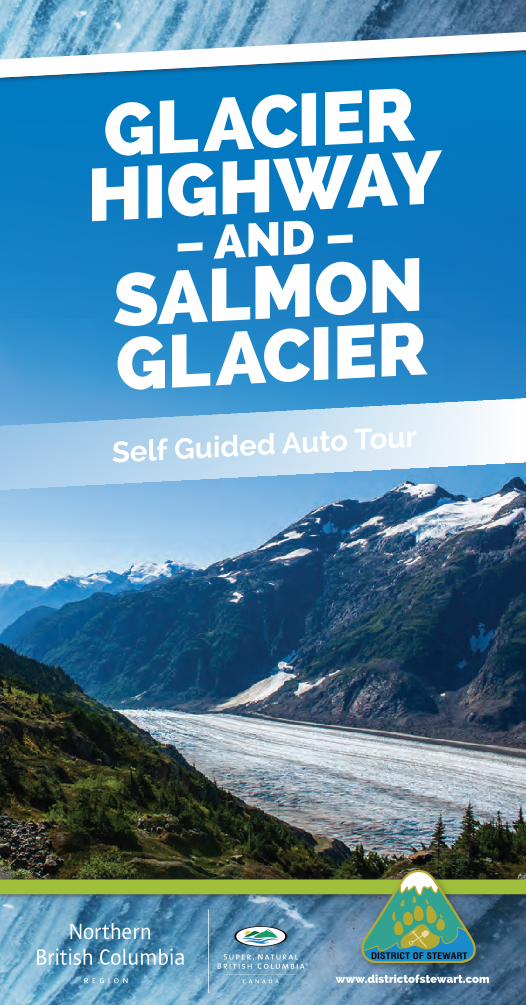
GlacierHiGHway
– aND –
SalmoNGlacierSelf Guided Auto Tour
www.districtofstewart.com
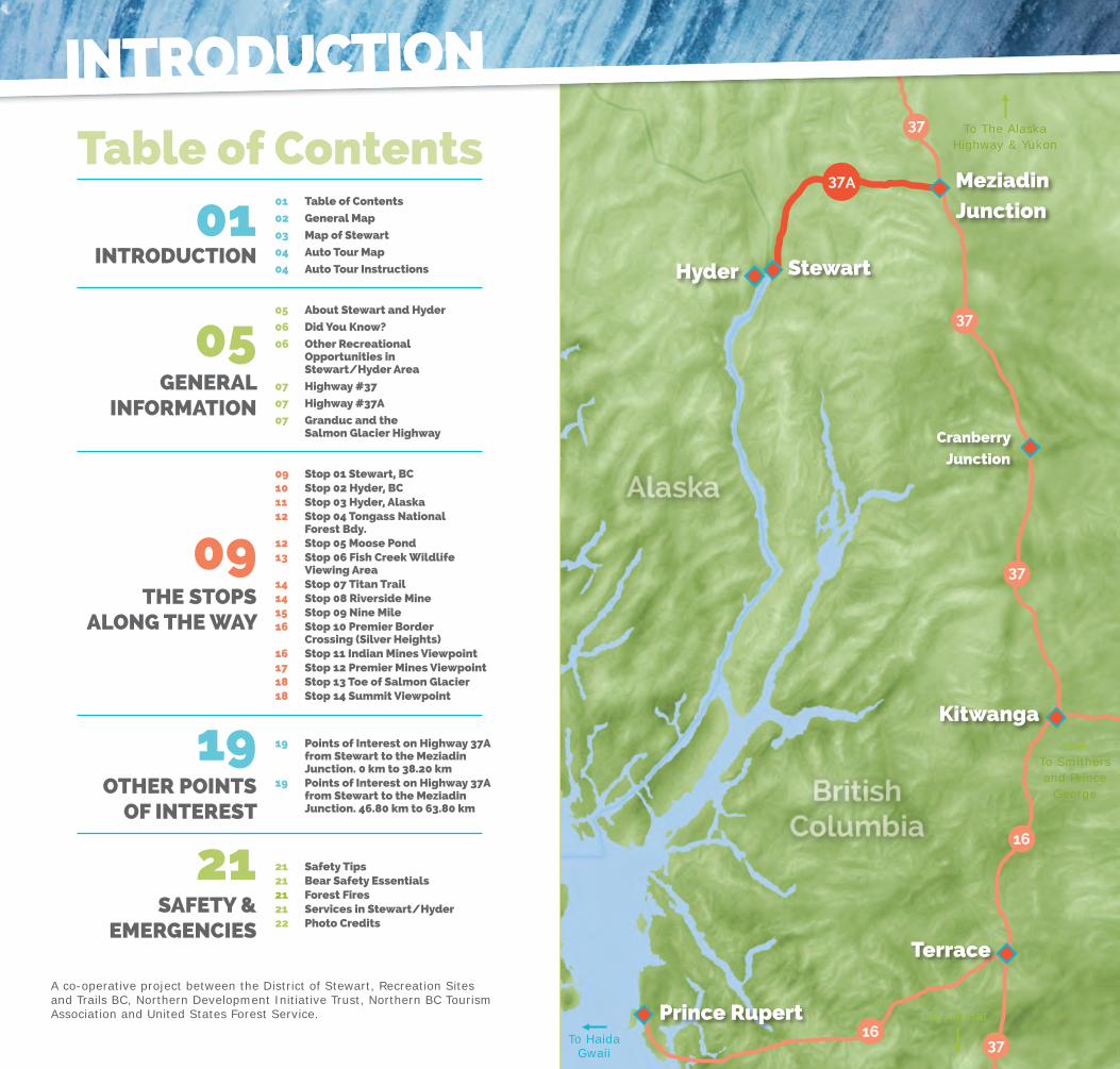
Prince Rupert
Terrace
Hyder
To The Alaska Highway & Yukon
To Kitimat
To HaidaGwaii
Kitwanga
CranberryJunction
Stewart
Meziadin Junction
16
37
3716
37A
37
37
IntroductIon
Table of Contents01 Table of Contents
02 General Map
03 Map of Stewart
04 Auto Tour Map
04 Auto Tour InstructionsInTRoduCTIon
05 About Stewart and Hyder
06 did You Know?
06 other Recreational opportunities in Stewart/Hyder Area
07 Highway #37
07 Highway #37A
07 Granduc and the Salmon Glacier Highway
GeneRAl InfoRMATIon
19 Points of Interest on Highway 37A from Stewart to the Meziadin Junction. 0 km to 38.20 km19 Points of Interest on Highway 37A from Stewart to the Meziadin Junction. 46.80 km to 63.80 km
oTHeR PoInTSof InTeReST
SAfeTY & eMeRGenCIeS
21 Safety Tips21 Bear Safety essentials21 forest fires21 Services in Stewart/Hyder22 Photo Credits
09 Stop 01 Stewart, BC10 Stop 02 Hyder, BC11 Stop 03 Hyder, Alaska12 Stop 04 Tongass national forest Bdy. 12 Stop 05 Moose Pond13 Stop 06 fish Creek Wildlife Viewing Area14 Stop 07 Titan Trail14 Stop 08 Riverside Mine15 Stop 09 nine Mile16 Stop 10 Premier Border Crossing (Silver Heights)16 Stop 11 Indian Mines Viewpoint17 Stop 12 Premier Mines Viewpoint18 Stop 13 Toe of Salmon Glacier18 Stop 14 Summit Viewpoint
THe SToPSAlonG THe WAY
IntroductIon
A co-operative project between the District of Stewart, Recreation Sites and Trails BC, Northern Development Initiative Trust, Northern BC Tourism Association and United States Forest Service.
To Smithersand Prince
George

Yu
ko
n D
r.
Rail
way
St.
Co
nw
ay
St.
Glacier
Drive
19th Ave
Davi
s S
t.
Dyke Road.
Dyke
Road.
Air
port
Eagl
e D
rive
Marm
ot
Dr.
Co
pp
er
Cre
sc
Rave
n S
t.
Main
St.
K
ing
St.
2nd Ave
3rd Ave
4th Ave
5th Ave
7th Ave
6th Ave
8th Ave
9th Ave
10th Ave
11th Ave
13th Ave
15th Ave
12th Ave
Van
cou
ver
St.
Vic
tori
a S
t.
Co
lum
bia
St.
Bri
gh
twell
St.
Glacier Highway (3
7A) Sluice Box
Bear River
Bridge
PortlandCanal
BearRiver
<--
To H
yder
Stewart BC.Government Services 1- MunicipalOffice/FireHall 2- ProvincialGovernmentBuilding/Courthouse 3 - Royal Canadian Mounted Police 4- EnvironmentCanadaWeatherOffice 5- StewartGeneralHospital/AmbulanceService 6- MunicipalLandfill
education 7 - Bear Valley School
Churches 8 - Saint Mark’s Church 9 - Charity Baptist Church 10 - St. Felix Church
Recreation 11 - Border Town Recycling 12 - Ball Field 13 - Ball Field 14 - “Soucie’s” Ball Field 15 - Tennis Court 16 - Ian McLeod Memorial Playground 17 - Memorial Park
Tourism Services 18 - Visitor Information Centre 19 - Rainey Creek Campground 20 - Sani-Dump
As you drive the Salmon Glacier (Granduc) Road, you will see numbered markers with the Salmon Glacier Self Guided Auto Tour logo along the route. Match the number on the sign post with the numbered paragraphs inthebrochuretodiscoverthehistoryandnatureoftheStewart/Hyderarea. Approximate distances of each point of interest are provided, starting from the Tourist Information Center in Stewart.
CAuTIon: The road beyond the Summit Viewpoint (Stop 14) is not maintained and may be closed due to active mining. uSe AT YouR oWn RISK!
Auto Tour Instructions
P o r t l a n dC a n a l
STEWART
HYDER
C a m b r iaI c e f i e l d
I c e f i e l d
I c e f i e l d
I c e f i e l d
I c e f i e l d
Texas G lacier
Boundary Glacier
E
S a l m o n
Gl a
cie
r
I c e f i e l d
E
MTBAYARD
ECANTU
MTN
G
!.PremierMine
Bridge Out
Ninemile(Ruins)
RiversideMine
!.MountainView
ALA
SKA
BR
ITIS
H C
OLU
MB
IA
EMTWELKER
!1(
!2(!3(
!4(!5(
!6(!7(
!8(
!9(
!01(
!11(!21(
!31(
!41(
GranducMine
EMT
DILWORTH
SummitLake
DivideLake
MonitorLake
LongLake
ClementsLake
!.
E
EMT SHORTYSTEVENSON
MTBUNTING
TONGASSNATIONAL FOREST
MTRAINEY
MTMAGEE
E
Sa
lm
on
Ri
ve
r
Be
ar
Ri
ve
r
T e x a s
Cr
ee
k EORE MTN
Am
er
ic
an
Cr
ee
k
Bi
tt
e r C r e e k
Berendon Glac ier 0 5 102.5
Kilometers
B a r n
e y Gu
l ch
G l a c i e rC
r e ek
¥¥A73
1
2
3
4
5
6
78
9
1011
13
12
14
1516
1718
1920
- 04 -

The communities of Stewart, British Columbia and Hyder, Alaska are located at the head of the 90 mile long Portland Canal. They are surrounded by the majestic coastal range of mountains and the Cambria IceFields.Theseicefields,withtheirvarious glaciers, provide some of North America’s most breathtaking scenery.
The Native term for the head of the Portland Canal is “Skam-A-Kounst”, variously interpreted as “Safe House” or “Strong House”; possibly it may have formed a place of retreat for theNisga’aasthefierceHaidaraidedtheir villages when inter-tribal wars broke out.
Before European settlers arrived in the area, First Nations from the nearby Nass Valley would travel to the area to hunt. However, the First Nations population remained nomadic and did not permanently settle in Stewart.
By 1910, Stewart boasted a large sawmill,telegraphoffice,electricalplant, telephone exchange, churches, hotels, regular shipping services and all the modern conveniences of the larger southern towns. Stewart and Hyder (then known as Portland City) were joined by a two mile long “road” onpilingsacrossthetideflats.Thearea now boasted close to 10,000 people. Much of the population still resided in tents but many buildings were being constructed along the waterfront. These buildings, like the road, all stood on pilings above the water. Remains of these structures, the pilings, are still visible on both the StewartandHydertideflats.
Mineral exploration and development which has taken place in the surrounding mountains and valleys since the early years of the 20th century, has been the mainstay of both communities. At one time there were more than 150 properties being worked in both Alaska and BC. The
About Stewart and Hyder
General InformatIon
discovery of high-grade ore at Premier in 1918 led to the development of one of the richest mineral deposits in B.C. Although not all mining properties developed over the years have been as successful as the Silbak Premier, collectively the various mines have madetheStewart/Hyderareaoneofthe major gold-silver districts in this part of North America.
Nowadays, Stewart has a population of approximately 500, with all the amenities of a larger town, including
restaurants, motels, gas stations, bakeries, and museums. The town’s colourful history is now chronicled in the Stewart Historical Museum, as well as a number of restored heritage buildings that are marked by historic signage.
TheStewart/Hyderareaoffersanexcellent range of outdoor recreational opportunitiesfromfishing,hiking,wildlife viewing and sightseeing from land and water.
Stewart is “Canada’s most northerly, ice-free port”
Mt. Rainey is the highest mountain in Canada, rising from the sea to 5,700 feet
The Portland Canal is the fourth longest fjord in the world
Salmon Glacier is the world’s largest road accessible glacier
Stewart and Hyder had a population of 10,000 in the 1920’s
There are 72 snow avalanche paths between Meziadin Junction and Stewart
Kermode bears are often seen in the area
Stewart has six major motion pictures to its credit including;
• BearIsland,starringDonaldSutherland,LloydBridges and Vanessa Redgrave (1979) • TheThing,starringKurtRussell(1982) • Iceman,starringTimothyHuttonandJohnLone(1984) • LeavingNormal,starringMegTilley,ChristineLahtiandBarbaraRussell(1992) • Insomnia,starringRobinWilliams,AlPacinoandHilarySwank(2002) • EightBelow,starringPaulWalker(2005) • PleasevisittheMuseumformoreinformationregardingthesefilms
did You Know?
other recreational opportunities Inthe Stewart/Hyder area
Trails
Titan Trail (USFS)
Sluice Box (RSTBC)
Ore Mountain (RSTBC)
United Empire Trail (RSTBC)
American Creek (RSTBC)
Rainey Creek (Dist. of Stewart)
The RSTBC maintains a small campground at Clements Lake, 13 km North of Stewart, on Highway 37A. There are also a number of privately operated campgrounds in both communities. Check locally for details and for the new Recreational Opportunites in Stewart, BC / Hyder, Alaska map.
General InformatIon
- 06 -

The Granduc (Salmon Glacier) Road was completed in 1965, from the Premier area, to the Granduc Mine site located 40 km (25 miles) north-northwest of Stewart. The road winds its way through some of the most spectacular and rugged scenery in the world as it passes along the eastern edge of the Salmon Glacier and Summit Lake to the site of the Granduc camp.
Itwas1931whenthefirstnotedcopper showing was discovered. No real interest in the area was shown until 1948, when Einar Kuala staked claims in the Leduc Area. In 1953, Granby Mines took an option on the property andflewindrillsandequipment.In1954, Newmont Mining Co., negotiated for half interest of Granduc Mines.
In 1964, Newmont began it’s development and it was decided a 17 km (11 mile) tunnel had to be driven under the mountain ridges and glaciers to get the ore from the Leduc camp to the concentrator site at Granduc camp. The tunnel was completed in 1968. Granduc operated until 1978, when production costs and copper prices saw the closure of the mine. In 1979, Canada Wide Mines Ltd., began rehabilitation of the property and operated it until 1983.· Work stopped and a total shutdown of the property occurred. In 2010 Castle ResourcesInc.acquireda100%interestin the Granduc property. In 2012 and 2013 there has been some mining and tunnel rehabilitation on site.
Granduc and the Salmon Glacier Road
CAuTIon! Dusty conditions and narrow sections are common, so be extremely careful when slowing, stopping or meeting oncoming traffic.
Slow down when road is wet, snowy, muddy, or if visibility is reduced.
If driving conditions are poor, wait awhile for them to improve - or plananotheractivityintheStewar/Hyder area.
Use of seatbelts is mandatory in both Alaska and British Columbia
Large motor homes and trailers are not recommended on the road past the Fish Creek Viewing Platform.
The road beyond the Summit Viewpoint (Stop 14), to the Granduc property, is not maintained and may be closed due to active mining.
uSe AT YouR oWn RISK!
Canada Border Services
The Salmon Glacier Self Guided Auto Tour takes you across the Canada - United States boundary. Upon return to Canada, all individuals must stop and report at the Canada Border ServicesOffice,locatedbetweenStewart and Hyder. Photo ID and Birth Certificateand/orPassportsrequiredupon entry to Canada.
Weather Warning
Be prepared for fast, changeable weather conditions, especially in alpine areas (it can snow in summer at higher elevations).
Mining Properties
Many of the mining remains are on private property and may be dangerous. Stay out of old shafts and do not vandalize any of the areas. Enjoy what you see, take only pictures and leave any artifacts for others to ‘discover’. Obey posted signs on mining properties.
CAReful dRIVInG IS eSSenTIAl onTHe SAlMon GlACIeR RoAd
Highway #37Highway 37, also know as the Stewart Cassiar Highway, is one of the main routes to and from the Yukon and Alaska. The turnoff to Highway 37A or the Glacier Highway is located at Meziadin Junction, 156km (97 miles) from the southern junction of Highway 37 and Highway 16 in Kitwanga, BC. For more information visit www.stewartcassiarhighway.com.
Highway #37AThe Glacier Highway is a 65km (40 mile) paved drive, running southwest to Stewart and the head of the Portland Canal. This route takes you past over 20 glacier formations overlooking the highway including Bear Glacier, a must see for every visitor. Wildlife is abundant in the region with bears, moose, fox, porcupineandmountaingoatsallfrequentingthearea.
Use of seatbelts is mandatory in British Columbia. Pass with caution. Be aware that large trucks travel the route 24 hours a day. Stop only when safe to do so, makesureyou’reoutoftheflowoftraffic.do noT SToP In AVAlAnCHe ZoneSuse headlights 24 hours a day.
driving Tips & Courtesy
- 08 -- 07 -
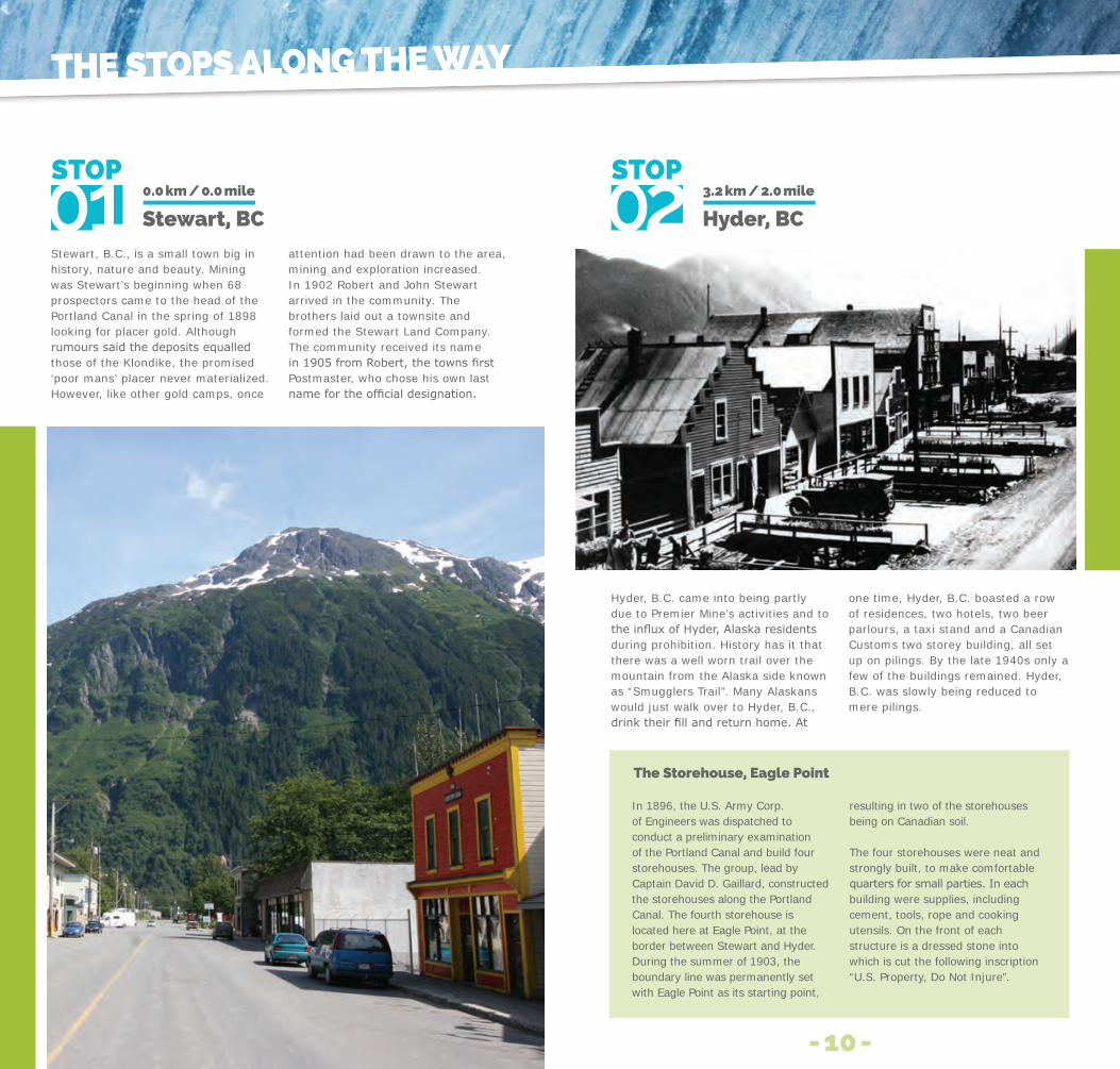
Stewart, B.C., is a small town big in history, nature and beauty. Mining was Stewart’s beginning when 68 prospectors came to the head of the Portland Canal in the spring of 1898 looking for placer gold. Although rumourssaidthedepositsequalledthose of the Klondike, the promised ‘poor mans’ placer never materialized. However, like other gold camps, once
attention had been drawn to the area, mining and exploration increased.In 1902 Robert and John Stewart arrived in the community. The brothers laid out a townsite and formed the Stewart Land Company. The community received its name in1905fromRobert,thetownsfirstPostmaster, who chose his own last namefortheofficialdesignation.
Stewart, BC0.0 km / 0.0 mile
The Storehouse, eagle Point
In 1896, the U.S. Army Corp. of Engineers was dispatched to conduct a preliminary examination of the Portland Canal and build four storehouses. The group, lead by Captain David D. Gaillard, constructed the storehouses along the Portland Canal. The fourth storehouse is located here at Eagle Point, at the border between Stewart and Hyder. During the summer of 1903, the boundary line was permanently set with Eagle Point as its starting point,
resulting in two of the storehouses being on Canadian soil.
The four storehouses were neat and strongly built, to make comfortable quartersforsmallparties.Ineachbuilding were supplies, including cement, tools, rope and cooking utensils. On the front of each structure is a dressed stone into which is cut the following inscription “U.S. Property, Do Not Injure”.
Hyder, B.C. came into being partly due to Premier Mine’s activities and to theinfluxofHyder,Alaskaresidentsduring prohibition. History has it that there was a well worn trail over the mountain from the Alaska side known as “Smugglers Trail”. Many Alaskans would just walk over to Hyder, B.C., drinktheirfillandreturnhome.At
one time, Hyder, B.C. boasted a row of residences, two hotels, two beer parlours, a taxi stand and a Canadian Customs two storey building, all set up on pilings. By the late 1940s only a few of the buildings remained. Hyder, B.C. was slowly being reduced to mere pilings.
Hyder, BC3.2 km / 2.0 mile
The STopS Along The WAyThe STopS Along The WAy
- 10 -
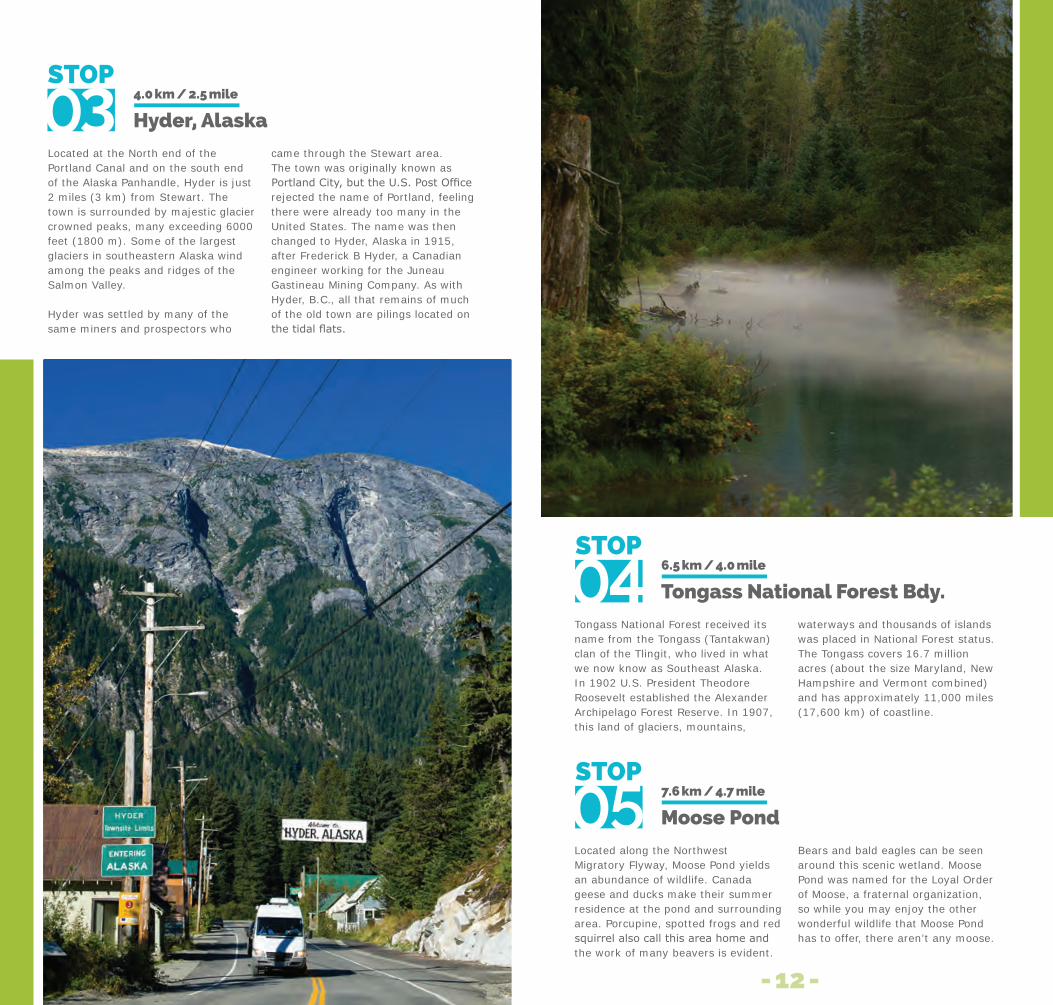
Located at the North end of the Portland Canal and on the south end of the Alaska Panhandle, Hyder is just 2 miles (3 km) from Stewart. The town is surrounded by majestic glacier crowned peaks, many exceeding 6000 feet (1800 m). Some of the largest glaciers in southeastern Alaska wind among the peaks and ridges of the Salmon Valley.
Hyder was settled by many of the same miners and prospectors who
came through the Stewart area. The town was originally known as PortlandCity,buttheU.S.PostOfficerejected the name of Portland, feeling there were already too many in the United States. The name was then changed to Hyder, Alaska in 1915, after Frederick B Hyder, a Canadian engineer working for the Juneau Gastineau Mining Company. As with Hyder, B.C., all that remains of much of the old town are pilings located on thetidalflats.
Hyder, Alaska4.0 km / 2.5 mile
Tongass National Forest received its name from the Tongass (Tantakwan) clan of the Tlingit, who lived in what we now know as Southeast Alaska. In 1902 U.S. President Theodore Roosevelt established the Alexander Archipelago Forest Reserve. In 1907, this land of glaciers, mountains,
waterways and thousands of islands was placed in National Forest status. The Tongass covers 16.7 million acres (about the size Maryland, New Hampshire and Vermont combined) and has approximately 11,000 miles(17,600 km) of coastline.
Tongass national forest Bdy.6.5 km / 4.0 mile
Located along the Northwest Migratory Flyway, Moose Pond yields an abundance of wildlife. Canada geese and ducks make their summer residence at the pond and surrounding area. Porcupine, spotted frogs and red squirrelalsocallthisareahomeandthe work of many beavers is evident.
Bears and bald eagles can be seen around this scenic wetland. Moose Pond was named for the Loyal Order of Moose, a fraternal organization, so while you may enjoy the other wonderful wildlife that Moose Pond has to offer, there aren’t any moose.
Moose Pond7.6 km / 4.7 mile
- 12 -

FishCreekoffersauniqueopportunityto view and photograph Alaskan Brown (Grizzlies) and Black bears. The bears come here to feed on the coho, chum and pink salmon which spawn in the creek. From July to September, the salmon run provides an extensive food supply for bears, sea gulls, bald eagles, wolves and others.
The U.S. Forest Service and the Alaska Department of Fish and Game are committed to providing a safe
environment tor bears and people. As bears are wild and unpredictable, please keep your distance.
Caution:Bearsfrequentlycrossthe road, coming down from steep slopestofishforsalmon.Toreducedisturbances to the bears, do not park or leave your car unattended on the side of the road throughout the entire area. Parking is permitted next to the wildlife observation platform.
fish Creek WildlifeViewing Area
9.6 km /6.0 mile
fish Creek Road House
The Fish Creek Road House was originally constructed to house workers building an aerial tram line from Premier Mine to the road head at saltwater. After the construction of the tram was completed, the cabin was used as a roadhouse for packers supplying the mines in the area.
Stories have it, that workers who were headed for town would stop at the roadhouse only to be distracted by an evening of drinking and other unsavoury activities. Many never did make it to town. The structure burned down in January 1962 and all that remains is the original chimney.
Titan Trail was constructed in 1922 by workers from the Titan Mine. The original trail was approximately 5 miles (8 km) long and provided access for horse and mule trains to carry supplies to the mine site and other claims in the area. The trail is now maintained by the U.S. Forest Service to the old mine site.
Titan Trail10.0 km / 6.2 mile
Discovered by the Lindsborg Brothers in 1915, the claims were sold and later became Riverside Mine. Development began in 1922 and some 4000 feet (1200 m) of tunnel was constructed over the next two years. In 1925, construction of a 60 ton mill began. The mine changed hands several times and was operated intermittently until 1961. In some years, the Riverside Mine was the most productive property in Alaska for silver and copper.
At one time, facilities at the mine includedthemineheadmill,quartersfor 60 workers, a cook shack and dining hall. By 1987 most of the original structures had burned down andriverfloodshadwashedouttheoriginal road. The present road now covers part of the original mine area. Today, only the remains of the burned structures identify the most important mining property in the Hyder area.
Riverside Mine14.1 km / 8.7 mile
- 13 -

At Nine Mile, Texas Creek joins the Salmon River as it widens out across thevalley,flowingsouthtothePortland Canal. Here the remains of the Nine Mile Bridge can be seen along the river bed. The bridge gave access to mineral properties in the Texas Creek drainage until 1967 when a dumping event from Summit Lake washed out the structure.
Summit Lake is a self dumping lake, located above the Salmon Glacier, and normally drains northward into upper BowserRiver.Thefirstrecordedflood(an event known as a Jokulhlaups, pronounced Yuck-a-lups) occurred
in December 1961. The lake drained under the glacier, raising the level of theriverandfillingitwithicebergs.Thisresultedincatastrophicfloodingalong the Salmon River valley.
Thelakethenbeganacycleoffillinganddraining,floodingtheSalmonRiver, causing damage to the road and bridges along the river. The event now occurs almost every year, raising the watertofloodlevelanddepositingicechunks along the river, but without much damage to the road.
nine Mile
16.6 km / 10.3 mile
The Texas Creek Bridge
Located 3 miles (5 km) up the Texas Creek drainage, it was at one time Alaska’s only covered bridge. It provided access to a number of mineral claims in the upper Texas Creek area from the time it was built in 1932 until 1965 when it was damaged under a heavy snow load. In 1978 the structurefinallycollapsed.
TheinternationalboundarybetweenAlaskaandB.C.wasofficiallydesignatedin 1903 by a commission established to resolve the Alaska - Canada boundary dispute. The Commission was made up of members from Canada, the United States and Great Britain.
The boundary area just below Premier, B.C., was referred to as Silver Heights. From the 1920s to the early 1950s miners going to work and residents of Premier Mine Camp had to stop here at a Canadian Customs building. The boundary line is 500 m back down the road and is marked by a small silver coloured cairn on the east side. Every ten years the entire length of the boundary, from Hyder north, is cleared.
Premier Border Crossing(Silver Heights)
21.0 km / 13.0 mile
Development of the Indian property began in 1910 when surface trenching was undertaken. The property was reorganized in 1923 under Indian Mines Corporation Ltd. They performed most of the underground development until 1925whenoperationsstopped.In1946,IndianMinesLtd.,acquiredtheholdingsand rehabilitated the camp in 1947.
Looking towards the hill directly to the west, the cut line for the old tramway which ran from the Indian Mine and Premier is still visible. Silbak Premier constructed the 3 km (2 mile) aerial tramline from the property in 1951. The ore, most of which was produced in 1952, was then transported across the valley on the tram and concentrated at Premier’s mill. There has been no active work on the claim since 1963.
Indian Mines Viewpoint23.1 km / 14.3 mile
- 15 -

Located on the eastern slope of the Salmon River Valley, Premier Mine was started in 1910. By 1918, Premier had developed into one of the richest mineral deposits in B.C. An 11 mile (17 km) aerial tramline was constructed to carry ore from Premier to tidewater and was one of the longest on the continent at that time. In 1921 the property shipped 6,000 tons of ore with the gold valued at $1,500,000 at that time.
Alargefiredevastatedthecampin1928, resulting in the destruction of most of the buildings. Through heroic efforts, the mill machine shop, compressor plant and tramheads were saved. These were vital to the operation of the mine as loss of them
could have resulted in the closure of the property. The camp was rebuilt and Premier Mine Camp once again became a thriving community.
Many years of success and continuous operation were experienced until low base metal prices forced closure in 1953. Development resumed in 1955 and continued sporadically until 1967. The property sat idle from 1967-1988, other than some exploration in the early 80s. In 1988, Westmin Mines began construction on the property and undertook open pit mining from 1989-1992. In 1993, Westmin began underground operations continuing until 1996.
Premier Mines Viewpoint
24.2 km / 15.0 mile
Looking down upon the Toe of Salmon Glacier and along the valley below you can see how the glacier is continually transforming the landscape and itself.
At the toe of the glacier you can see a series of small ridgelike accumulations. These ridges are made up of till that have been deposited across the valley, and are known as Terminal or End Moraines. These Terminal Moraines mark standstill positions of a present or past glacier front.
Notice the small ponds located below the toe. These depressions, known as Kettles, are formed by the melting of
buried ice blocks, which are stranded on the outwash plain after the glacier recedes. The colour is caused by the finematerialssuspendedinthewater.
Glaciers move by three methods, gravity, internal deformation and by basal slip, when the ice mass slidesoveritsbedonafilmofwater.Sections of the glacier can move at differentrates.Inconfinedvalleyglaciers the fastest ice currents are at the centre of the ice surface. A shearing effect results on the surface due to this difference in speed, splitting open the ice to for crevasses.
Toe of Salmon Glacier
27.7 km / 17.2 mile
The landscape around you is the result of several periods of glaciation. The most recent, known as the Fraser Glaciation period, reached its peak around 14,000 years ago. This is when the ice sheet reached its maximum size, covering much of what we now know as British Columbia and Alaska, with the exception of the Queen Charlotte Ranges and parts of the Rocky Mountains. In these high
mountains, summits and ridges stood above the ice surface and classic alpine landforms were created.
As climatic conditions improved the ice sheet began its slow retreat and the land began to rise, leaving the landscape much as you see it today. TheSalmonGlacier,thefifthlargestin Canada, is a remnant of that last great age of glaciers.
Summit Viewpoint
37.0 km / 22.9 mile
- 18 -

Other POints Of interest
0.0 kmStewart Information Centre.
3.00 kmBear River Bridge and the entrance to Stewart townsite. Beginning of United Empire Hiking Trail which will pass the United Empire Mine ruins (1925 - 1936).
7.40 kmDunwell log yard, named after Dunwell Mine (1926 - 1941). Glacier Creek waterfall.
10.20 kmWards Pass Cemetery. Named after Ward Brightwell, an early settler. Brightwell was the original owner of the Mountain Boy Mine.
14.10 kmBitter Creek Bridge.
14.40 km Clements Lake, a Recreation Sites and Trails BC Campsite & Ore Mountain hiking trail (Locally known as Bear Lake).
15.10 kmPullout with litter barrels & avalanche gates. Look for mountain goats high up on the surrounding mountains.
16.30 kmOn the west you can view the waterfalls known as the Wall of Tears.
21.90 kmBeaver dams & eagles in this area.
22.70 kmThis is where the Bear River crosses the valley from east to west. This is also the begining of the American Creek Trail.
23.00 kmPullout with litter barrels.
26.90kmEntering the narrow steep walled Bear River Canyon; watch for rocks on the road.
32.00kmThis area has a stretch of dead trees killed as a result of an avalanche.
33.20kmThe George Copper property, comprised of four claims, covering over 1000 hectares. No stopping allowed, as this is an active avalanche area.
37.60kmPullout with view of Bear Glacier. In 1975 the glacier reached this side of the valley. Morning light is best for photographing this spectacular glacier. Look for the old highway seen above the road.
38.20kmStrohn Lake - from 1958 to 1962 the lakeoverflowedtheBearGlacierfivetimes, taking out all bridges except the main Stewart Bridge. Stewart itself is protected from the river by the roadbed of the Old Portland Canal Shortline Railway. On July 23, 1967 the toe of the Bear Glacier melted through, marking the end of Strohn Lake as a localfloodthreat.StrohnLakeistheheadwaters of the Bear River.
Points of Interest on Highway 37A from Stewart to the Meziadian Junction
46.80kmWindy Point Summit and pullout.
50.00kmStart of Porcupine Hill.
50.80kmSurprise Creek pullout.
51.3kmSurprise Creek Bridge.
59.60kmHighway Maintenance camp& avalanche gate.
63.80kmJunction Highway 37 and Glacier Highway information and pullout.
Other POints Of interest
- 19 -

Respect all bears - they all can be dangerous.
Never approach a bear.
Never attempt to feed a bear.
Be defensive - never surprise a bear.
Learn about bears. Anticipate and avoid encounters.
Bear Safety essentials
Before leaving on a hike, let a responsible individual know where you are going and when you will be returning. Always contact that individual when you return. Never hike alone.
Always take a map, compass, food and emergency gear.
In case of an emergency contact the Royal Canadian Mounted Police.
Safety Tips
forest firesShouldyouspotaforestfireinBritishColumbiacall1-800-663-5555or call *5555 toll free on most cellular networks.
Thisisafree,provincewide,forestfireemergencyphonenumber.
Services in Stewart/HyderFood and Lodging: A number of food and lodging establishments are located in the communities of Stewart and Hyder. Grocery stores are located in Stewart.
Public Library and Internet Services available.
Police:The Royal Canadian Mounted Police detachment is located at 707 Conway Street, Stewart.ph: 911
Hospital: The Stewart Health Centre is located at 904 Brightwell Street, ph: 250-636-2221
B.C. Ambulance Service: ph: 911 (Emergency Calls)
Visitor Centres:
Stewart: 222 5th Avenue, ph: 250-636-9224,toll free: 1-888-366-5999,
Hyder: Community AssociationBuilding, ph: 250-636-9148
PostOffices:
Canada Post: 5th and Brightwell, Stewart.
U.S. Postal Service: Hyder.
CanadianandU.S.fishinglicensesavailable.(Enquirelocally.)
Safety and emergencieS
District of Stewart United States Forest Service Hyder Community Association Stewart Museum Society British Columbia Forest Service Steve Kirkbride Vancouver Island Helicopters Jim Hyslop Les Deacon Rogers
Trina Calder Regional District of Kitimat Stikine Channel Collective Simon Ratcliffe Tim Swanky J.F. Bergeron Stewart Hyder International
Chamber of Commerce Stewart Historical Society
Photo Credits:
Safety and emergencieS
- 21 -

GlacierHiGHway
– aND –
SalmoNGlacier
A co-operative project between the District of Stewart, Recreation Sites and Trails BC, Northern Development Initiative Trust,
Northern BC Tourism Association and United States Forest Service.
www.districtofstewart.com