sth 57 reconstruction project brown, kewaunee and door...
TRANSCRIPT
�
STH 57 Reconstruction Project Brown, Kewaunee and Door Counties, Wisconsin
WisDOT Project ID: 1480-04-00
AGENDA
�
PROPOSED INTERPRETIvE PANElSWequiock Falls County Park Kiosk, Brown County
Project Introduction Panel (*Duplicate panel is also located at the CTH C Park & Ride kiosk)Project Timeline Panel (*Duplicate panel is also located at the CTH C Park & Ride kiosk)Cultural Traditions Panel (*Duplicate panel is also located at the CTH C Park & Ride kiosk)Delfosse-Allard Site PanelHoldorf & Christoff Sites PanelHeyrman I Site PanelFabry Creek (Boss Tavern) Site PanelBeaudhuin Village Site Panel
CTH C Park & Ride Kiosk, Door CountyProject Introduction Panel (*Duplicate panel is also located at the Wequiock Falls Park kiosk)Project Timeline Panel (*Duplicate panel is also located at the Wequiock Falls Park kiosk)Cultural Traditions Panel (*Duplicate panel is also located at the Wequiock Falls Park kiosk)Historic Settlement of the Door PeninsulaBelgian Community following the Peshtigo FireVandermissen Brickworks SiteA List of those Who Perished at Williamsonville during the Peshtigo Fire
•
•
•
•••••
•
•
•
••••
�
Wequiock Falls Park kiosk BroWn county, Wisconsin
Proposed Panels for Public Interpretation Kiosk
�
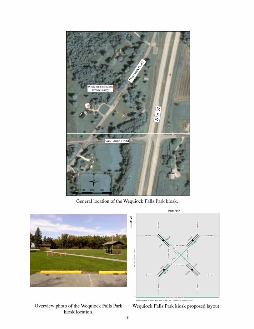
Wequiock Falls KioskBrown County
Ü0 100 200 300 40050 Feet
STH
57
Weq
uiock
Road
Van Lanen Road
General location of the Wequiock Falls Park kiosk.
Panel #
1
Panel #
2
Panel #
5
Panel #
6
Panel #
3
Panel #
4
Panel #
7
Panel #
8
3fe
et4
inche
s
3 feet 4 inches
3 feet 4 inches
5 feet3
feet
4inc
hes
5 feet
11 feet 4 inches
11fee
t 4 inches
Panels measure 38 inches wide (side to side) and 26 inches tall (top to bottom)
48inc
hes
48 inches
48 inches 48 inches
48 inches
48inc
hes
48inc
hes
48inc
hes
198
inche
s(1
6fe
et6
inche
s)
198 inches (16 feet 6 inches)
Park Path
N
Overview photo of the Wequiock Falls Park kiosk location.
Wequiock Falls Park kiosk proposed layout
�
Project Introduction Panel - Wequiock Falls County Park Kiosk, Brown County *Duplicate panel is also located at the CTH C Park & Ride kiosk
�
Project Timeline Panel - Wequiock Falls County Park Kiosk, Brown County *Duplicate panel is also located at the CTH C Park & Ride kiosk
�
Project Culture Panel - Wequiock Falls County Park Kiosk, Brown County *Duplicate panel is also located at the CTH C Park & Ride kiosk
�
Delfosse-Allard Site Panel - Wequiock Falls County Park Kiosk, Brown County
�
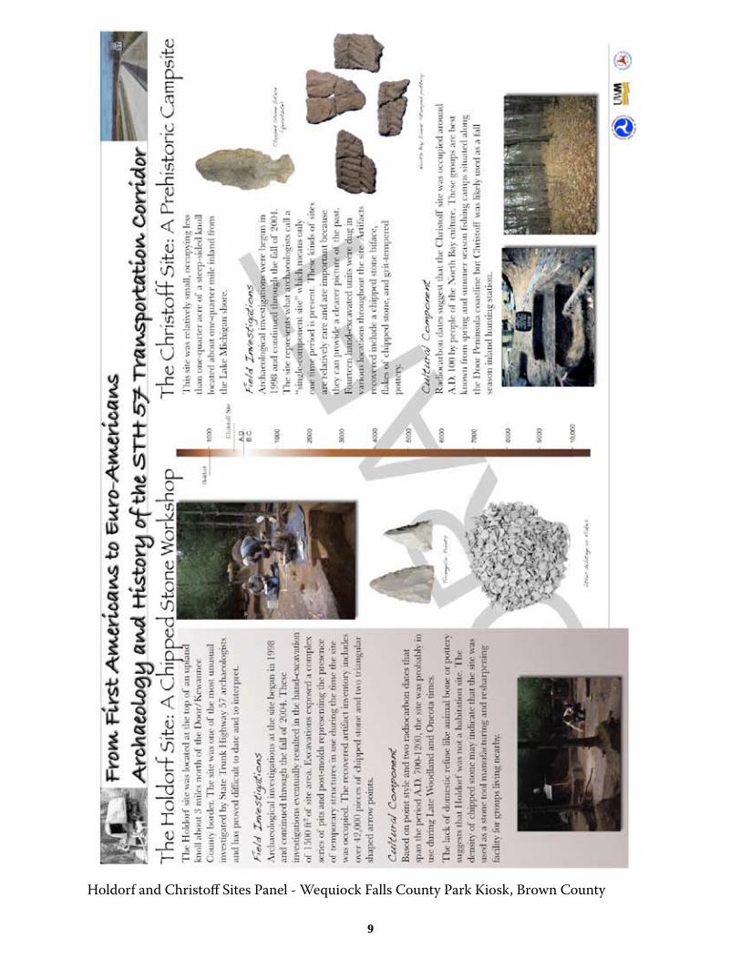
Holdorf and Christoff Sites Panel - Wequiock Falls County Park Kiosk, Brown County
�0
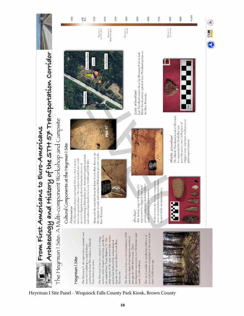
Heyrman I Site Panel - Wequiock Falls County Park Kiosk, Brown County
��
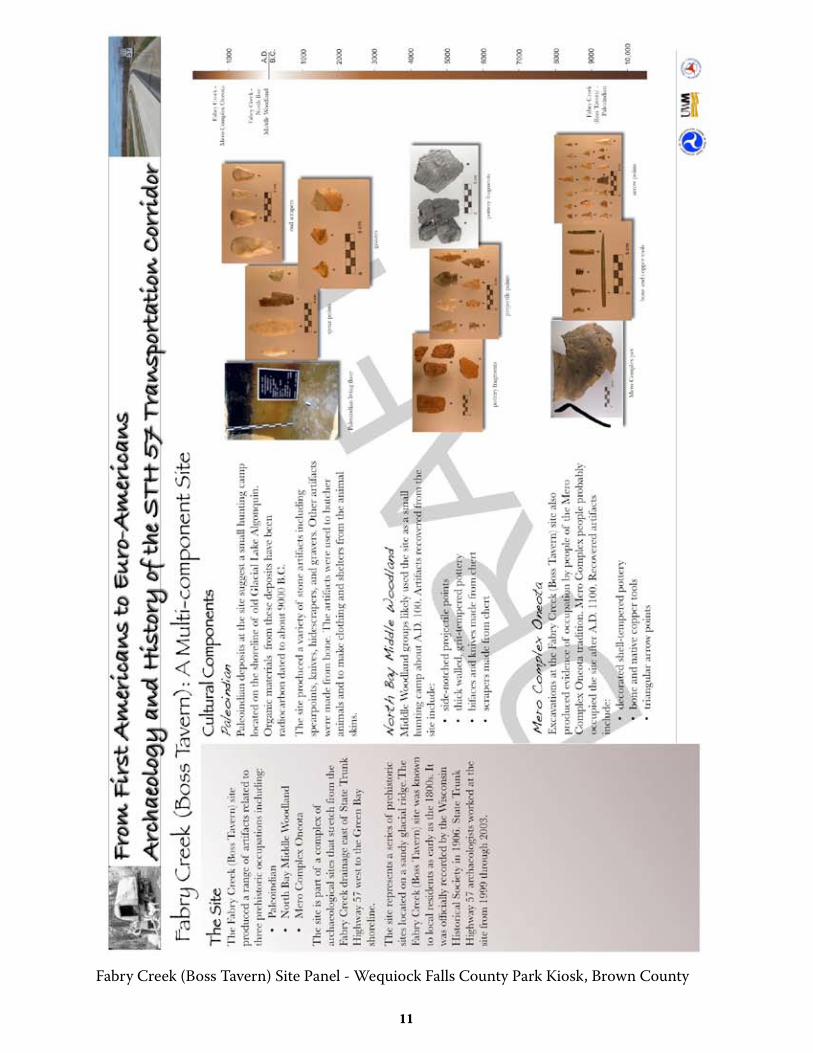
Fabry Creek (Boss Tavern) Site Panel - Wequiock Falls County Park Kiosk, Brown County
��
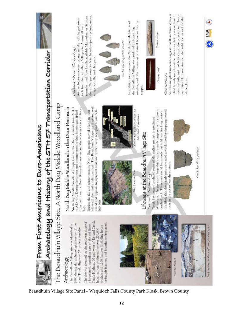
Beaudhuin Village Site Panel - Wequiock Falls County Park Kiosk, Brown County
��
ctH c Park and ride kiosk door county, Wisconsin
Proposed Panels for Public Interpretation Kiosk
��
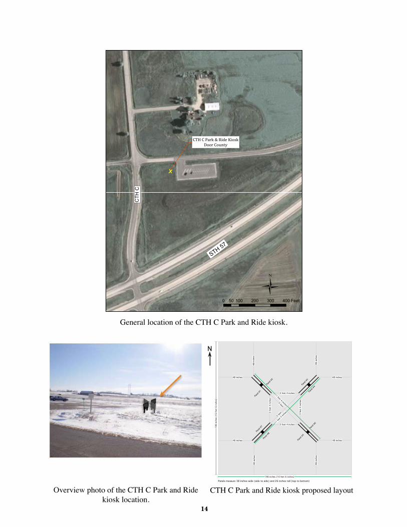
CTH C Park & Ride KioskDoor County
Ü0 100 200 300 40050 Feet
CTH
C
STH 57
General location of the CTH C Park and Ride kiosk.
Panel #
1
Panel #
2
Panel #
5
Panel #
6
Panel #
3
Panel #
4
Panel #
7
Panel #
8
3fe
et4
inche
s
3 feet 4 inches
3 feet 4 inches
5 feet3
feet
4inc
hes
5 feet
11 feet 4 inches
11fee
t 4 inches
Panels measure 38 inches wide (side to side) and 26 inches tall (top to bottom)
48inc
hes
48 inches
48 inches 48 inches
48 inches
48inc
hes
48inc
hes
48inc
hes
198
inche
s(1
6fe
et6
inche
s)
198 inches (16 feet 6 inches)
Park Path
N
Overview photo of the CTH C Park and Ride kiosk location.
CTH C Park and Ride kiosk proposed layout
��
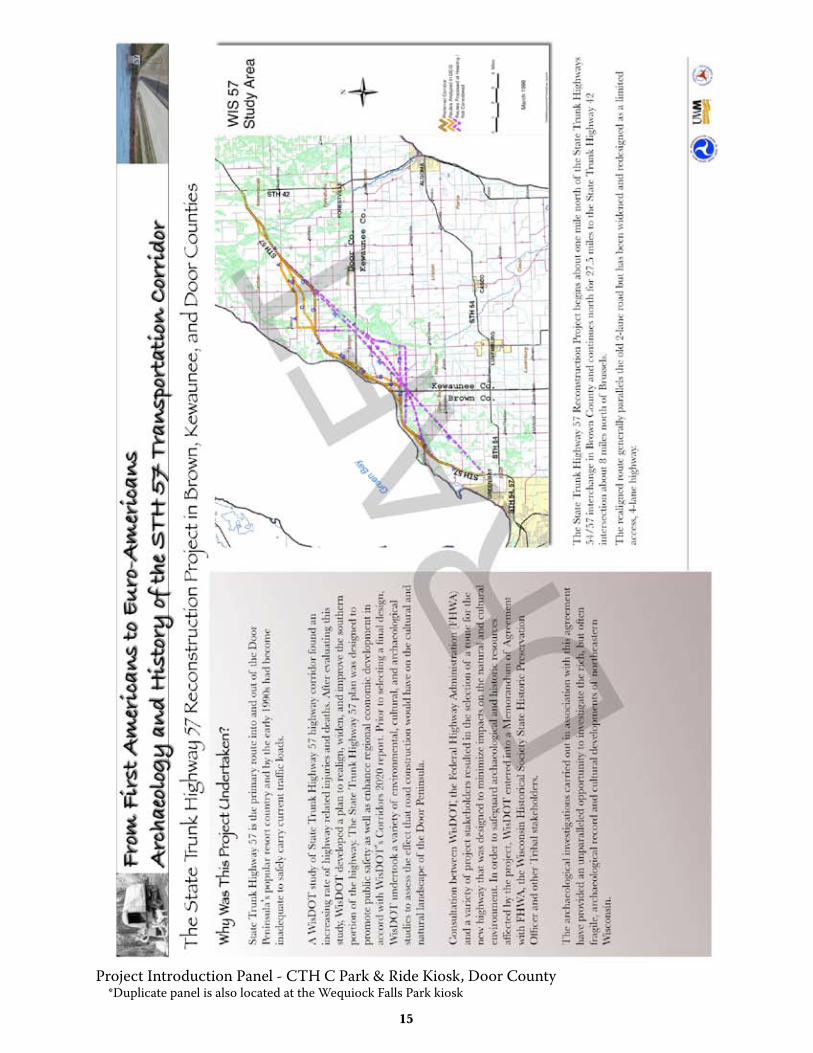
Project Introduction Panel - CTH C Park & Ride Kiosk, Door County *Duplicate panel is also located at the Wequiock Falls Park kiosk

��
Project Timeline Panel - CTH C Park & Ride Kiosk, Door County *Duplicate panel is also located at the Wequiock Falls Park kiosk

��
Project Culture Panel - CTH C Park & Ride Kiosk, Door County *Duplicate panel is also located at the Wequiock Falls Park kiosk
��
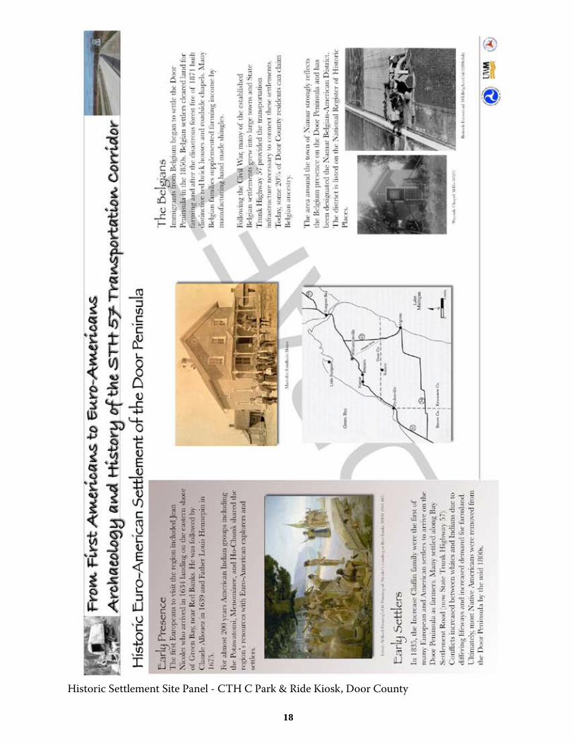
Historic Settlement Site Panel - CTH C Park & Ride Kiosk, Door County
��
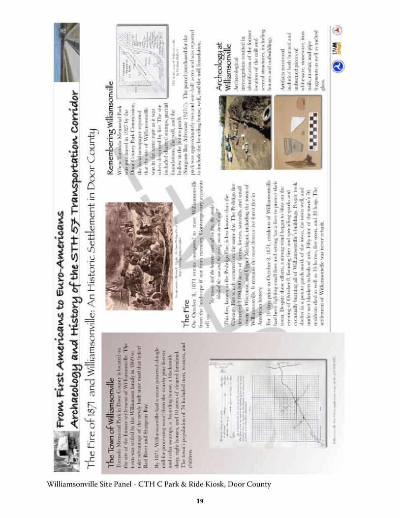
Williamsonville Site Panel - CTH C Park & Ride Kiosk, Door County
�0
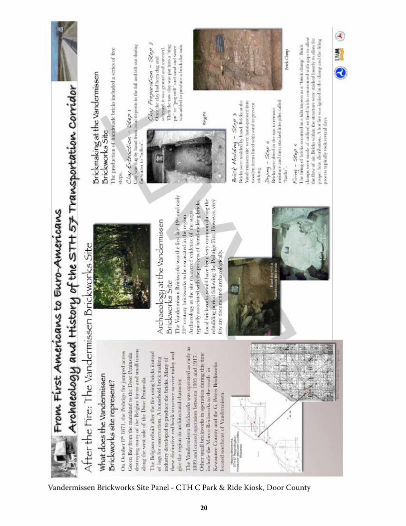
Vandermissen Brickworks Site Panel - CTH C Park & Ride Kiosk, Door County
��
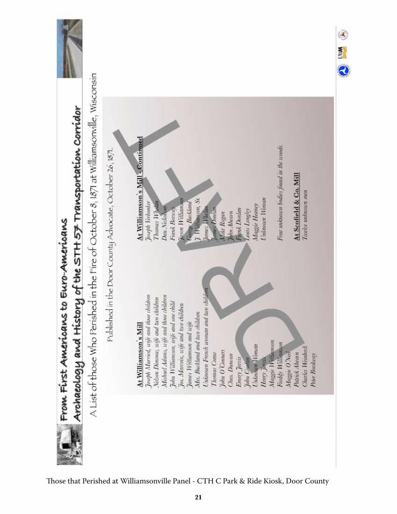
Those that Perished at Williamsonville Panel - CTH C Park & Ride Kiosk, Door County
��
PROPOSED STH 57 FlyER
Dra
ftSTH 57 ProjecT Background
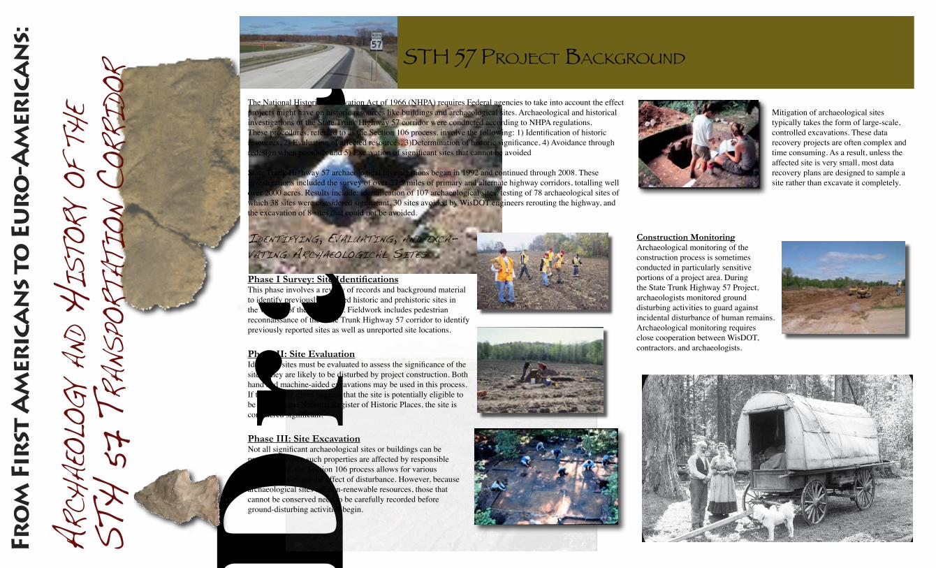
Mitigation of archaeological sites typically takes the form of large-scale, controlled excavations. These data recovery projects are often complex and time consuming. As a result, unless the affected site is very small, most data recovery plans are designed to sample a site rather than excavate it completely.
arcH
aeol
ogy a
nd H
isto
ry oF
tHe
stH
57 t
rans
Port
atio
n cor
rido
r
Fro
m F
irst
Am
eric
an
s to
Eu
ro
-Am
eric
an
s:
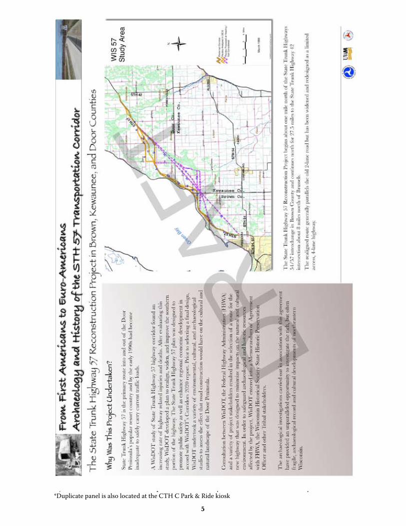
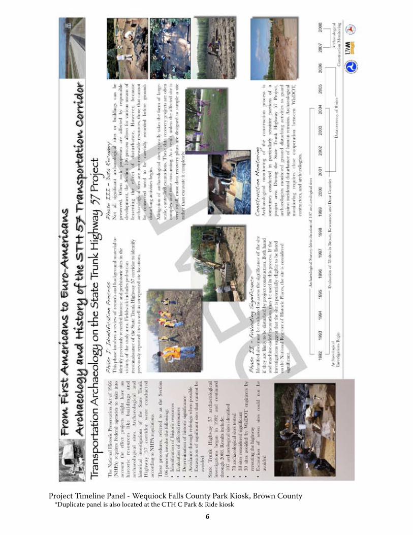
The National Historic Preservation Act of 1966 (NHPA) requires Federal agencies to take into account the effect projects might have on historic resources like buildings and archaeological sites. Archaeological and historical investigations of the State Trunk Highway 57 corridor were conducted according to NHPA regulations.These procedures, referred to as the Section 106 process, involve the following: 1) Identification of historic resources, 2) Evaluation of affected resources, 3)Determination of historic significance, 4) Avoidance through redesign when possible, and 5) Excavation of significant sites that cannot be avoided
State Trunk Highway 57 archaeological investigations began in 1992 and continued through 2008. These investigations included the survey of over 27.5 miles of primary and alternate highway corridors, totalling well over 2000 acres. Results include: identification of 107 archaeological sites, testing of 78 archaeological sites of which 38 sites were considered significant, 30 sites avoided by WisDOT engineers rerouting the highway, and the excavation of 8 sites that could not be avoided.
identiFying, evaluating, and exca-vating arcHaeological sites
Phase I Survey: Site IdentificationsThis phase involves a review of records and background material to identify previously recorded historic and prehistoric sites in the vicinity of the study area. Fieldwork includes pedestrian reconnaissance of the State Trunk Highway 57 corridor to identify previously reported sites as well as unreported site locations.
Phase II: Site EvaluationIdentified sites must be evaluated to assess the significance of the site if they are likely to be disturbed by project construction. Both hand and machine-aided excavations may be used in this process. If the investigations suggest that the site is potentially eligible to be listed on the National Register of Historic Places, the site is considered significant.
Phase III: Site ExcavationNot all significant archaeological sites or buildings can be preserved. When such properties are affected by responsible development, the Section 106 process allows for various means of lessening the effect of disturbance. However, because archaeological sites are non-renewable resources, those that cannot be conserved need to be carefully recorded before ground-disturbing activities begin.
Construction MonitoringArchaeological monitoring of the construction process is sometimes conducted in particularly sensitive portions of a project area. During the State Trunk Highway 57 Project, archaeologists monitored ground disturbing activities to guard against incidental disturbance of human remains. Archaeological monitoring requires close cooperation between WisDOT, contractors, and archaeologists.
Dra
ft
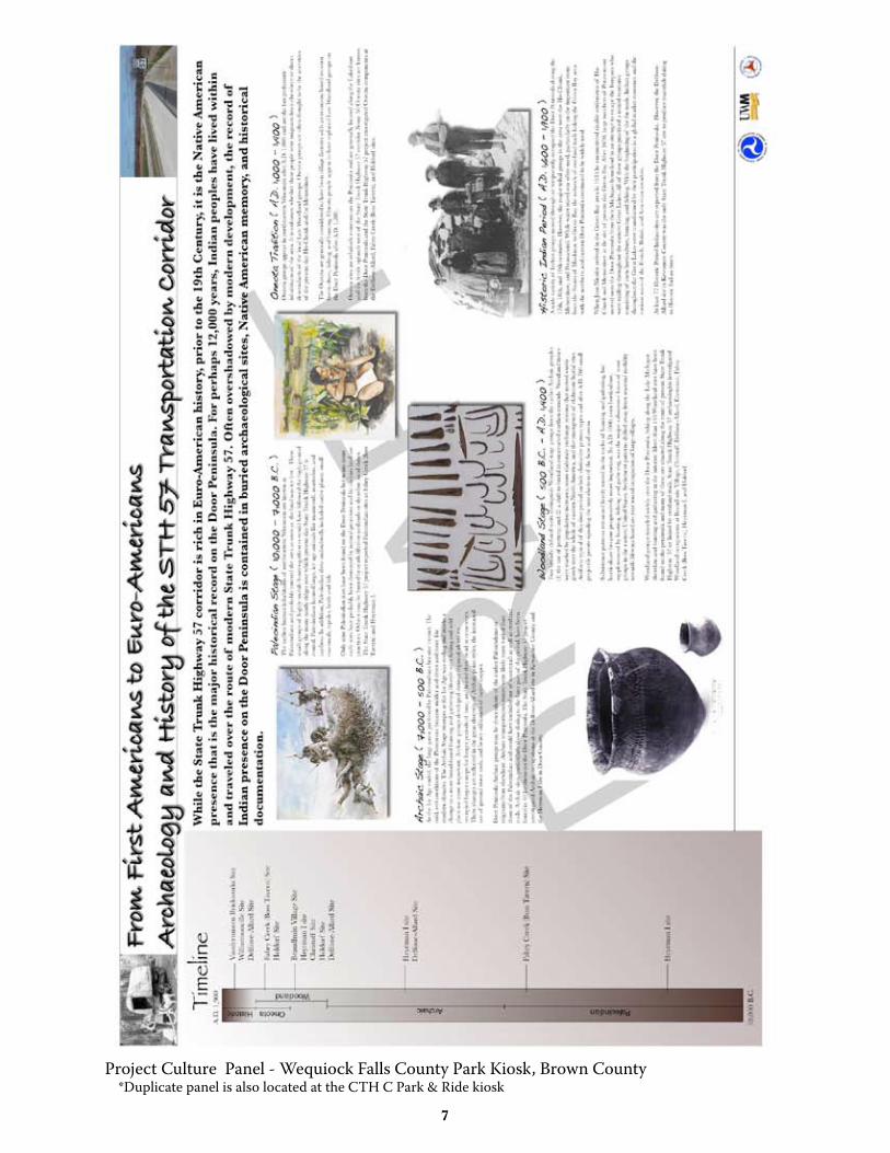
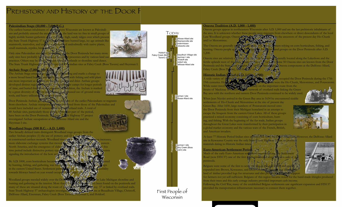
Paleoindian Stage (10,000 - 7,000 B.C.)The earliest human inhabitants of northeastern Wisconsin are known as Paleoindi-ans and probably entered the area as soon as the land was ice free in small groups of highly mobile hunter-gatherers along the many high, sandy ridges over which present day State Trunk Highway 57 is routed. Paleoindians hunted large, ice age animals like mammoth, mastodon, and caribou supplemented undoubtedly with native plants, small mammals, reptiles, birds and fish.
Only nine Paleoindian sites have been found on the Door Peninsula but many more early sites have probably been destroyed by natural processes and by various land use practices. Others may be buried beneath filled-in wetlands or shoreline sand dunes. The State Trunk Highway 57 project reported Paleoindian sites at Fabry Creek (Boss Tavern) and Heyrman I.
Archaic Stage (7,000 - 500 B.C.)The Archaic Stage emerges as the Ice Age was ending and marks a change to a more broad-based hunting and gathering lifestyle with fishing and wild plant use more important as the climate became warmer and drier. Archaic groups developed distinct regional identities, occupied larger camps for longer periods of time, and buried their dead in cemeteries. In addition, the Archaic is marked by a great diversity of Archaic point styles, the increased use of ground stone tools, and heavy utilization of native copper.
Door Peninsula Archaic groups may be descendants of the earlier Paleoindians or migrants from elsewhere. Archaic transportation routes differed from those of the Paleoindian and would have included use of watercraft as well as overland trails. A total of 40 Archaic sites, particularly those dating to the later part of the period, have been on the Door Peninsula. The State Trunk Highway 57 project investigated Archaic occupations at the Delfosse-Allard site and the Heyrman I site.
Woodland Stage (500 B.C. - A.D. 1,400)Two broadly defined traits distinguish Woodland stage groups from the earlier Archaic peoples: (1) the use of pottery; and (2) a shift to burial in constructed earthen mounds. Woodland times were marked by population increases, more elaborate exchange systems that moved exotic goods over the whole of eastern North America, and the emergence of elaborate burial rites. Artifacts typical of this time period include distinctive pottery types and after A.D. 700 small projectile points signaling the introduction of the bow and arrow.
By A.D. 1000, corn horticulture became progressively more important, supplemented by hunting, fishing, and gathering, was the major subsistence focus of most groups in the eastern United States. Settlement patterns shifted away from seasonal mobility towards lifeways based on year round occupation of large villages.
Woodland groups traveled widely over the Door Peninsula, fishing along the Lake Michigan shoreline and hunting and gathering in the interior. More than 140 Woodland sites have been found on the peninsula and many of these are situated along the route of present State Trunk Highway 57 or linked by overland trails. State Trunk Highway 57 archaeologists investigated Woodland occupations at Beaudhuin Village, Christoff, Delfosse-Allard, Eisenman, Fabry Creek (Boss Tavern), Heyrman I, and Holdorf.
PreHiSTory and HiSTory of THe door PeninSula
Oneota Tradition (A.D. 1,000 - 1,400)Oneota groups appear in northeastern Wisconsin after A.D. 1,000 and are the last prehistoric inhabitants of the area. It is unknown whether these people were migrants from elsewhere or direct descendants of the local Late Woodland groups. Oneota groups are often thought to be the ancestors of the present day Ho-Chunk and/or Menominee.
The Oneota are generally considered to have been village farmers relying on corn horticulture, fishing, and hunting. Oneota people appear to have replaced Late Woodland groups on the Door Peninsula after A.D. 1,200.
Oneota sites are relatively common on the Peninsula and are generally located along the Lakeshore and the fertile uplands west of the State Trunk Highway 57 corridor. Some 50 Oneota sites are known from the Door Peninsula and the State Trunk Highway 57 project investigated Oneota components at the Delfosse-Allard, Fabry Creek (Boss Tavern), and Holdorf sites.
Historic Indian Period (A.D. 1,600 - 1,900)A wide variety of Indian groups moved through or temporarily occupied the Door Peninsula during the 17th-19th centuries. However, the major tribal groups in the area were the Ho-Chunk, Menominee, and Potawatomi. While water travel was often used, particularly on the important route from the Straits of Mackinac to Green Bay, the network of overland trails linking the Green Bay area with the northern and eastern Door Peninsula continued to be widely used.
When Jean Nicolet arrived in the Green Bay area in 1634 he encountered sizable settlements of Ho-Chunk and Menominee at the site of present day Green Bay. After 1650, large numbers of Potawatomi moved onto the Door Peninsula from their Michigan homeland in an attempt to escape the Iroquois from the eastern Great Lakes. All of these groups practiced a mixed economy consisting of corn horticulture, hunt-ing, and fishing. With the beginning of the fur trade, Indian groups throughout the Great Lakes were transformed by their participation in a global market economy and the various wars of the French, British, and American invaders.
At least 77 Historic Period Indian sites are reported from the Door Peninsula. However, the Delfosse-Allard site in Kewaunee County was the only State Trunk Highway 57 site to produce materials dating to Historic Indian times.
Euro-American Settlement PeriodMuch of the early Euro-American settlement occurred along Bay Settlement Road (now STH 57) one of the first roads established along the west side of the peninsula.
Belgians were some of the first to settle the area in the mid 1850s and quickly expanded into Brown, Kewaunee, and Door Counties. They set out clearing the land of timber provided logs for structures and also provided a means of support for farmers not yet self-sufficient. Belgians of this region became noted for the hand-made shingles produced from their trees and this early cottage industry provided important cash income. Following the Civil War, many of the established Belgian settlements saw significant expansion and STH 57 provided the transportation infrastructure necessary to connect them together.
Today
First People of Wisconsin
Arch
aic
Woo
dlan
dO
neot
aH
isto
ricPa
leoi
ndia
n
Heyrman I siteFabry Creek (Boss Tavern) site
Heyrman I siteDelfosse-Allard site
Beaudhuin Village siteHeyrman I siteChristoff siteHoldorf siteDelfosse-Allard site
Holdorf siteFabry Creek (Boss
Tavern) site
Delfosse-Allard siteWilliamsonville siteVandermissen Brickworks site
��
STH 57 PROjECT WEBSITE
��
3/7/11 9:06 AM - Mar 7, 2011STH 57 Project: 1992-2008
Page 1 of 1http://archaeolab.anthro.uwm.edu/STH_57_Project/index.html
Project Navigation
Home
Project Overview
Environment
Cultural History
Reports
Links
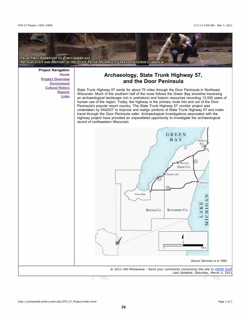
Archaeology, State Trunk Highway 57,and the Door Peninsula
State Trunk Highway 57 winds for about 75 miles through the Door Peninsula in NortheastWisconsin. Much of the southern half of the route follows the Green Bay shoreline traversingan archaeological landscape rich in prehistoric and historic resources recording 12,000 years ofhuman use of the region. Today, the highway is the primary route into and out of the DoorPeninsula's popular resort country. The State Trunk Highway 57 corridor project wasundertaken by WisDOT to improve and realign portions of State Trunk Highway 57 and maketravel through the Door Peninsula safer. Archaeological investigations associated with thehighway project have provided an unparalleled opportunity to investigate the archaeologicalrecord of northeastern Wisconsin.
(Source: Benchely et al 1996)
© 2011 UW-Milwaukee - Send your comments concerning the site to HRMS StaffLast Updated: Saturday, March 5, 2011
��
3/7/11 9:14 AM - Mar 7, 2011STH 57 Project: 1992-2008 - Overview
Page 1 of 1http://archaeolab.anthro.uwm.edu/STH_57_Project/projover.html
Project Navigation
Home
Project Overview
Environment
Cultural History
Reports
Links
Archaeology, State Trunk Highway 57,and the Door Peninsula
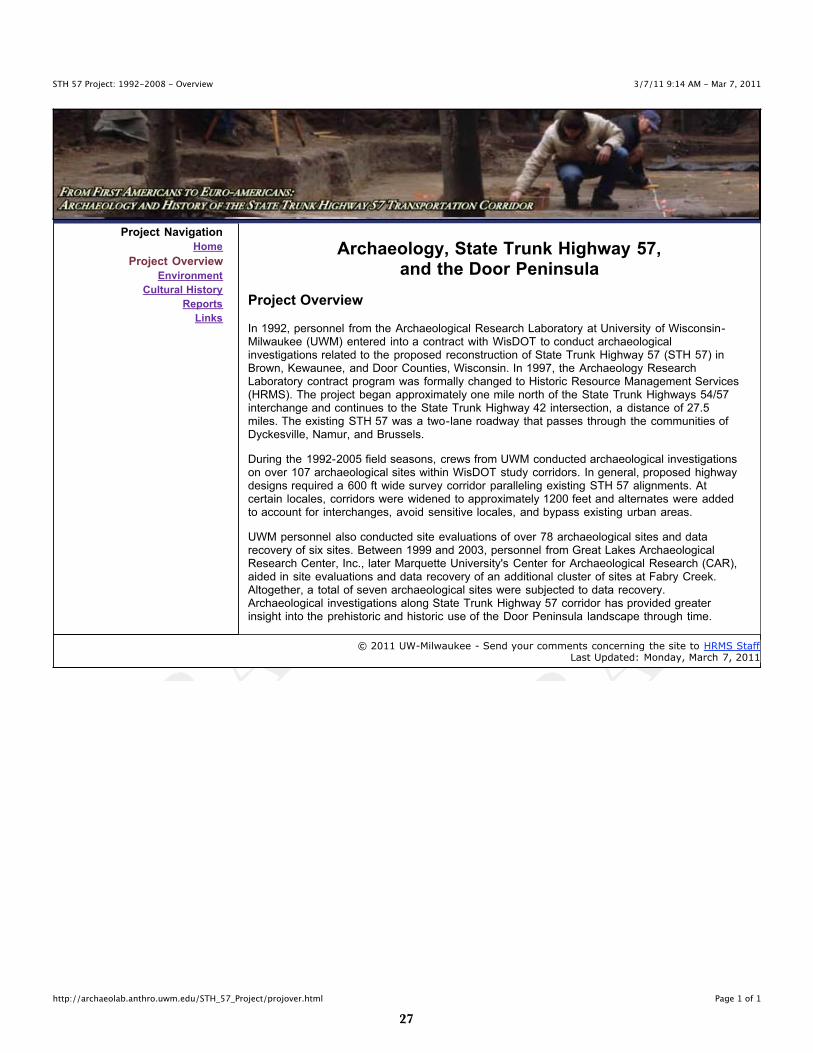
Project Overview
In 1992, personnel from the Archaeological Research Laboratory at University of Wisconsin-Milwaukee (UWM) entered into a contract with WisDOT to conduct archaeologicalinvestigations related to the proposed reconstruction of State Trunk Highway 57 (STH 57) inBrown, Kewaunee, and Door Counties, Wisconsin. In 1997, the Archaeology ResearchLaboratory contract program was formally changed to Historic Resource Management Services(HRMS). The project began approximately one mile north of the State Trunk Highways 54/57interchange and continues to the State Trunk Highway 42 intersection, a distance of 27.5miles. The existing STH 57 was a two-lane roadway that passes through the communities ofDyckesville, Namur, and Brussels.
During the 1992-2005 field seasons, crews from UWM conducted archaeological investigationson over 107 archaeological sites within WisDOT study corridors. In general, proposed highwaydesigns required a 600 ft wide survey corridor paralleling existing STH 57 alignments. Atcertain locales, corridors were widened to approximately 1200 feet and alternates were addedto account for interchanges, avoid sensitive locales, and bypass existing urban areas.
UWM personnel also conducted site evaluations of over 78 archaeological sites and datarecovery of six sites. Between 1999 and 2003, personnel from Great Lakes ArchaeologicalResearch Center, Inc., later Marquette University's Center for Archaeological Research (CAR),aided in site evaluations and data recovery of an additional cluster of sites at Fabry Creek.Altogether, a total of seven archaeological sites were subjected to data recovery.Archaeological investigations along State Trunk Highway 57 corridor has provided greaterinsight into the prehistoric and historic use of the Door Peninsula landscape through time.
© 2011 UW-Milwaukee - Send your comments concerning the site to HRMS StaffLast Updated: Monday, March 7, 2011
��
3/7/11 1:54 PM - Mar 7, 2011STH 57 Project: 1992-2008 - Environment
Page 1 of 1http://archaeolab.anthro.uwm.edu/STH_57_Project/environ.html
Project Navigation
Home
Project Overview
Environment
Cultural History
Reports
Links
Archaeology, State Trunk Highway 57,and the Door Peninsula
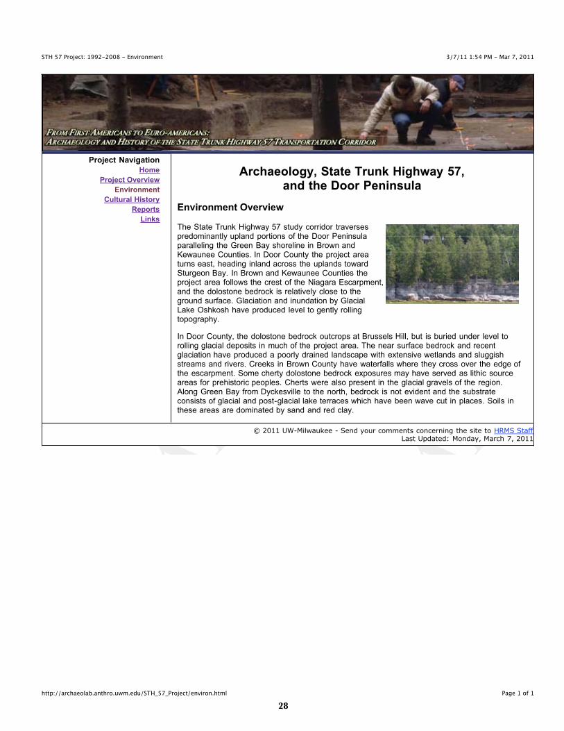
Environment Overview
The State Trunk Highway 57 study corridor traversespredominantly upland portions of the Door Peninsulaparalleling the Green Bay shoreline in Brown andKewaunee Counties. In Door County the project areaturns east, heading inland across the uplands towardSturgeon Bay. In Brown and Kewaunee Counties theproject area follows the crest of the Niagara Escarpment,and the dolostone bedrock is relatively close to theground surface. Glaciation and inundation by GlacialLake Oshkosh have produced level to gently rollingtopography.
In Door County, the dolostone bedrock outcrops at Brussels Hill, but is buried under level torolling glacial deposits in much of the project area. The near surface bedrock and recentglaciation have produced a poorly drained landscape with extensive wetlands and sluggishstreams and rivers. Creeks in Brown County have waterfalls where they cross over the edge ofthe escarpment. Some cherty dolostone bedrock exposures may have served as lithic sourceareas for prehistoric peoples. Cherts were also present in the glacial gravels of the region.Along Green Bay from Dyckesville to the north, bedrock is not evident and the substrateconsists of glacial and post-glacial lake terraces which have been wave cut in places. Soils inthese areas are dominated by sand and red clay.
© 2011 UW-Milwaukee - Send your comments concerning the site to HRMS StaffLast Updated: Monday, March 7, 2011
��
3/7/11 9:14 AM - Mar 7, 2011STH 57 Project: 1992-2008 - Culture History
Page 1 of 3http://archaeolab.anthro.uwm.edu/STH_57_Project/culturehist.html
Project Navigation
Home
Project Overview
Environment
Cultural History
Reports
Links
Archaeology, State Trunk Highway 57,and the Door Peninsula
Culture History
The following section provides a brief overview of the archaeological sites andassociated cultural components identified along the State Trunk Highway 57reconstruction corridor project.
Prehistoric
back to top
Paleoindian (11,500 - 8,000 B.C.)
Paleoindian sites are generally small and widely scatterd. Sites are typicallylocated in upland settings, along the margins of river valleys, and along theshores of ancient lakes and marshes. Some sites that are located in the vicinityof modern wetlands may be possible ancient game overlooks. The Paleoindianperiod is traditionally divided into the Early Paleoindian period and the LatePaleoindian period.
Both the Fabry Creek (Boss Tavern) and Heyrman I sites produced Paleoindiancomponents.
back to top
Archaic (8,000 - 1,000 B.C.)
The Archaic period in Wisconsin overlaps somewhat with the latter portions ofthe Late Paleoindian and the beginning of the Early Woodland periods. Threedefining cultural shifts occurred during the Archaic period. First, subsistencepractices moved to a broader procurement strategy by humans exploiting agreater diversity of small games and gathering a wider variety of wild plantresources. Second, Archaic traditions lack pottery. Lastly, the deceased weresometimes interred in natural features on the landscape such as gravel knollsor ridges.
The Archaic period may be further subdivided into three temporal stages EarlyArchaic (8,000 - 6,000 B.C.), Middle Archaic (6,000 - 3,000 B.C.), and LateArchaic (3,000 - 1,000 B.C.). The Early Archaic is distinguished from LatePaleoindian groups by the development of side notched projectile points. Duringthe Middle Archaic, people began to manufacture ground stone tools such asadzes and axes. The Late Archaic witnessed the establishment of extraregional trade. These trade networks provided a means to exchange exoticmaterials such as marine conch shell and native copper.
Many Late Archaic habitation sites are located near navigable waterways. Notonly did the wetlands, lakes, and rivers provide a diverse wealth of subsistenceresources, but they also facilitated the transport of exotic material via waterroutes. In the Late Archaic, subsistence strategies included a greater emphasison whitetail deer (Odocoileus virginianus). Deer meat was supplemented bysmaller mammals, some fish, and avian species, and the gathering of wild plantfoods such as nuts. The Late Archaic also marks the emergence of moundbuilding practices, the use of red ocher in funerary rites, and the deposition of
Overview
Culture History
Prehistoric
Paleoindian
Archaic
Woodland
Early
Middle
Late
Oneota
Historic
Euro-American
Archaeological Sites
Beaudhuin Village
Fabry Creek (BossTavern)
Christoff
Delfosse-Allard
Heyrman I
Holdorf
VandermissenBrickworks
Williamsonville
�0
3/7/11 9:14 AM - Mar 7, 2011STH 57 Project: 1992-2008 - Culture History
Page 2 of 3http://archaeolab.anthro.uwm.edu/STH_57_Project/culturehist.html
grave goods in burials.
The Heyrman I site also contains an Archaic component.
back to top
Woodland (1,000 B.C. - A.D. 1,000)
As with the Archaic period, the Woodland period may be further subdivided intothree chronological subunits: Early Woodland (1,000 B.C. - 300 B.C.), MiddleWoodland (300 B.C. - A.D. 400), and Late Woodland (A.D. 400 - A.D. 1,000).Overall, the Woodland period was a time of increasing sedentism, and it isduring the Woodland period that pottery and the bow and arrow make their firstappearance. The Woodland period was also a time of increasing reliance onplant foods and intensive mound construction. Preferred locations for Woodlandsites include interior bends of rivers near stream confluences within the vicinityof wetland resources.
back to top
Early Woodland (1,000 B.C. - 300 B.C.)
The emergence of the Early Woodland period is generally considered to becoincident with the introduction of thick-walled, grit-tempered pottery, such asMarion Thick. Early Woodland pottery sometimes exhibits cord impressionsdecorations on both outer and inner surfaces and is sometimes decorated withincised lines. Projectile points of the Early Woodland begin to displayincreasingly noticeable stylistic variations.
back to top
Middle Woodland (300 B.C. - A.D. 400)
Changes in styles of projectile points, pottery, and the intensity of moundbuilding mark the transition from Early to Middle Woodland. Middle Woodlandsettlement sites are large and suggest seasonal occupation over a number ofyears. Plant foods became increasingly important at this time, especially theharvesting of seed plants such as wild rice (Zizania palustris) in floodplainenvironments. Animal foods included various land animals, aquatic animals, andbirds.
The North Bay phase is thought to represent the archaeological remains ofNative Americans living in northeast Wisconsin during Middle Woodland times.The North Bay phase is primarily defined by its plain surfaced, grit-temperedpottery decorated with dentate, linear, corded, and cord-wrapped stick stampingin banded patterns.
The Beaudhuin Village site is a North Bay fall and winter camp site that alsoincludes a transitional Middle to Late Woodland component.
back to top
Late Woodland (A.D. 400 - A.D. 1,200)
The bow and arrow first appear in the archaeological record of northeasternWisconsin during the Late Woodland period.
Late Woodland sites are known in a variety of ecological settings suggesting apattern of subsistence that relied upon seasonal movement to specific anddependable resources. Some examples of such seasonal resources includetrapping waterfowl in wetlands during their spring migration or gathering wildrice in the autumn. Wild rice, chenopodium, blackberry, plum, cherry, and nativehoneysuckle are among preferred Late Woodland plant resources. Lake troutand whitefish have been identified in archaeological remains as well suggestingthe development of an inland fishery to compliment hunting of game animals.
Archaeologists have identified three main Door Peninsula types of LateWoodland sites: small campsites, villages, and mound groups. Late Woodland
��
3/7/11 9:14 AM - Mar 7, 2011STH 57 Project: 1992-2008 - Culture History
Page 3 of 3http://archaeolab.anthro.uwm.edu/STH_57_Project/culturehist.html
habitation sites were often located along small bays, near river mouths, and insandy terrace and dune areas on both sides of the peninsula. In the past, manyconical mounds were reported on the Door Peninsula, especially along theshore of Green Bay from Sturgeon Bay south. Unfortunately, most moundswere destroyed before professional archaeological investigations took place.
The Heyrman I, Christoff, Delfosse-Allard, and Holdorf sites all contained LateWoodland components, while the Beaudhuin Village Site presented evidence ofa transitional Middle to Late Woodland occupation.
back to top
Oneota (A.D. 900 - A.D. 1,400)
The Oneota practiced a mixed economy of corn horticulture, fishing, gathering,and hunting of whitetail deer. Plain surfaced, shell tempered pottery that is oftendecorated with incised design motifs is diagnostic of an Oneota presence.Oneota groups replaced Late Woodland people on the Door Peninsula afterA.D. 1,200. Present day Ho-Chunk and/or Menominee tribes may bedescendent of these peoples.
The Holdorf site contained an Oneota component and the Fabry Creek (BossTavern) site has a potential Oneota component.
back to top
Historic Euro-American
Archaeological research conducted along the State Trunk Highway 57 projectcorridor identified several historic Euro-American sites including VandermissenBrickworks and the town of Williamsonville. The Vandermissen Brickworks siterepresents a cottage industry brick making facility. The Williamsonville site isthe location of the town of Williamsonville that was destroyed during thePeshtigo Fire in 1871.
back to top
© 2011 UW-Milwaukee - Send your comments concerning the site to HRMS StaffLast Updated: Wednesday, March 2, 2011
��
3/7/11 1:04 PM - Mar 7, 2011STH 57 Project: 1992-2008 - Beaudhuin Village Site
Page 1 of 2http://archaeolab.anthro.uwm.edu/STH_57_Project/bvs.html
Project Navigation
Home
Project Overview
Environment
Cultural History
Reports
Links
Archaeology, State Trunk Highway 57,and the Door Peninsula
Beaudhuin Village Site
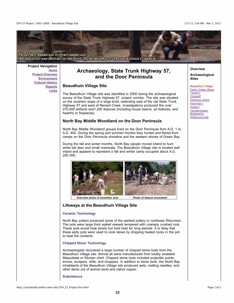
The Beaudhuin Village site was identified in 2000 during the archaeologicalsurvey of the State Trunk Highway 57 project corridor. The site was situatedon the southern slope of a large knoll, extending east of the old State TrunkHighway 57 and west of Renard Creek. Investigations produced the over270,000 artifacts and1,200 features (including house basins, pit features, andhearths or fireplaces).
North Bay Middle Woodland on the Door Peninsula
North Bay Middle Woodland groups lived on the Door Peninsula from A.D. 1 toA.D. 400. During the spring and summer months they hunted and fished fromcamps on the Door Peninsula shoreline and the western shores of Green Bay.
During the fall and winter months, North Bay people moved inland to huntwhite-tail deer and small mammals. The Beaudhuin Village site is located wellinland and appears to represent a fall and winter camp occupied about A.D.200-300.
Overview photo of excavtion area Photo of feature excavation
Lifeways at the Beaudhuin Village Site
Ceramic Technology
North Bay potters produced some of the earliest pottery in northeast Wisconsin.The pots were large thick walled vessels tempered with coarsely crushed rock.These pots would heat slowly but hold heat for long periods. It is likely thatthese early pots were used to cook stews by dropping heated rocks in the potto heat the contents.
Chipped Stone Technology
Archaeologists recovered a large number of chipped stone tools from theBeaudhuin Village site. Almost all were manufactured from locally availableMaquoketa or Silurian chert. Chipped stone tools included projectile points,knives, scrapers, drills, and choppers. In addition to stone tools, the North Bayinhabitants of the Beaudhuin Village site produced awls, matting needles, andother items out of animal bone and native copper.
Subsistence
Overview
ArchaeologicalSites
Beaudhuin Village
Fabry Creek (BossTavern)
Christoff
Delfosse-Allard
Heyrman I
Holdorf
VandermissenBrickworks
Williamsonville
��
3/7/11 9:16 AM - Mar 7, 2011STH 57 Project: 1992-2008 - Beaudhuin Village Site
Page 2 of 2http://archaeolab.anthro.uwm.edu/STH_57_Project/bvs.html
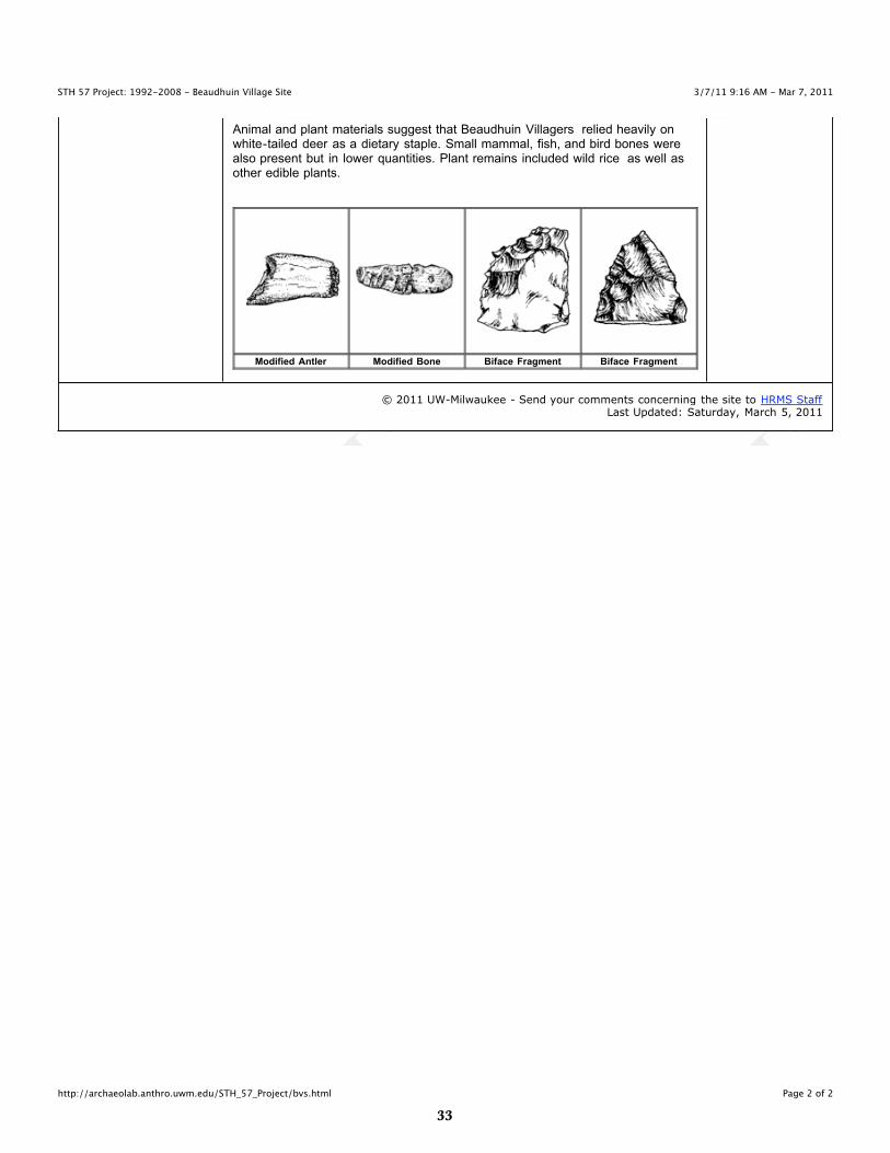
Animal and plant materials suggest that Beaudhuin Villagers relied heavily onwhite-tailed deer as a dietary staple. Small mammal, fish, and bird bones werealso present but in lower quantities. Plant remains included wild rice as well asother edible plants.
Modified Antler Modified Bone Biface Fragment Biface Fragment
© 2011 UW-Milwaukee - Send your comments concerning the site to HRMS StaffLast Updated: Saturday, March 5, 2011
��
3/7/11 9:16 AM - Mar 7, 2011STH 57 Project: 1992-2008 - Fabry Creek (Boss Tavern) Site
Page 1 of 2http://archaeolab.anthro.uwm.edu/STH_57_Project/boss.html
Project Navigation
Home
Project Overview
Environment
Cultural History
Reports
Links
Archaeology, State Trunk Highway 57,and the Door Peninsula
Fabry Creek (Boss Tavern) Site
The Fabry Creek (Boss Tavern) site produced a range of artifacts related tothree prehistoric occupations including:
• Paleoindian• North Bay Middle Woodland• Mero Comples Oneota
The site is part of a complex of archaeological sites that stretch from the FabryCreek drainage east of State Trunk Highway 57 west to the Green Bayshoreline.
The site represents a series of prehistoric sites located on a sandy glacial ridge.The Fabry Creek (Boss Tavern) site was known to local residents as early asthe 1800s. It was officially recorded by the Wisconsin Historical Society in1906. State Trunk Highway 57 archaeologists worked at the site from 1999through 2003.
Cultural Components
Paleoindian
Paleoindian deposits at the site suggest a small hunting camp located on theshoreline of old Glacial Lake Algonquin. Organic materials from these depositshave been radiocarbon dated to about 9000 B.C.
The site produced a variety of stone artifacts including spearpoints, knives,hidescrapers, and gravers. Other artifacts were made from bone. The artifactswere used to butcher animals and to make clothing and shelters from theanimal skins.
North Bay Middle Woodland
Middle Woodland groups likely used the site as a small hunting camp aboutA.D. 100. Artifacts recovered from the site include:
• side-notched projectile points• thick walled, grit-tempered pottery• bifaces and knives made from chert• scrapers made from chert
Mero Complex Oneota
Excavations at the Fabry Creek (Boss Tavern) site also produced evidence ofoccupation by people of the Mero Complex Oneota tradition. Mero Complexpeople probably occupied the site after A.D. 1100. Recovered artifacts include:
• decorated shell-tempered pottery• bone and native copper tools• triangular arrow points
Overview
ArchaeologicalSites
Beaudhuin Village
Fabry Creek (BossTavern)
Christoff
Delfosse-Allard
Heyrman I
Holdorf
VandermissenBrickworks
Williamsonville
��
3/7/11 9:16 AM - Mar 7, 2011STH 57 Project: 1992-2008 - Fabry Creek (Boss Tavern) Site
Page 2 of 2http://archaeolab.anthro.uwm.edu/STH_57_Project/boss.html
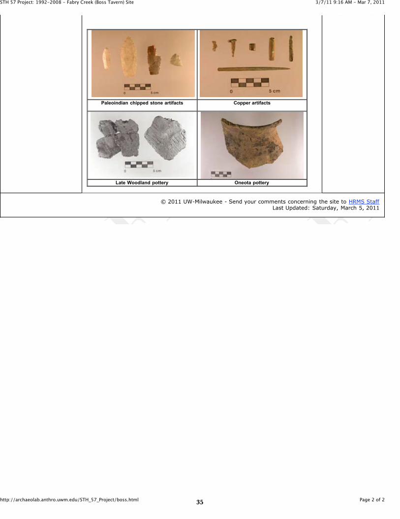
Paleoindian chipped stone artifacts Copper artifacts
Late Woodland pottery Oneota pottery
© 2011 UW-Milwaukee - Send your comments concerning the site to HRMS StaffLast Updated: Saturday, March 5, 2011
��
3/7/11 9:17 AM - Mar 7, 2011STH 57 Project: 1992-2008 - Christoff Site
Page 1 of 1http://archaeolab.anthro.uwm.edu/STH_57_Project/christoff.html
Project Navigation
Home
Project Overview
Environment
Cultural History
Reports
Links
Archaeology, State Trunk Highway 57,and the Door Peninsula
Christoff Site
This site was relatively small, occupying less than one-quarter acre of a steep-sided knoll located about one-quarter mile inland from the Lake Michigan shore.
Field Investigations
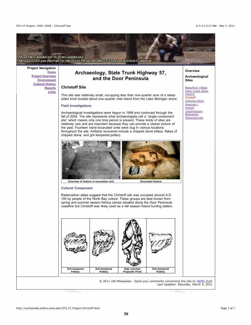
Archaeological investigations were begun in 1998 and continued through thefall of 2004. The site represents what archaeologists call a “single-componentsite” which means only one time period is present. These kinds of sites arerelatively rare and are important because they can provide a clearer picture ofthe past. Fourteen hand-excavated units were dug in various locationsthroughout the site. Artifacts recovered include a chipped stone biface, flakes ofchipped stone, and grit-tempered pottery.
Overview of feature in excavation unit. Excavated feature
Cultural Component
Radiocarbon dates suggest that the Christoff site was occupied around A.D.100 by people of the North Bay culture. These groups are best known fromspring and summer season fishing camps situated along the Door Peninsulacoastline but Christoff was likely used as a fall season inland hunting station.
Grit-temperedPottery
Grit-temperedPottery
Side-notchedProjectile Point
Grit-temperedPottery
Overview
ArchaeologicalSites
Beaudhuin Village
Fabry Creek (BossTavern)
Christoff
Delfosse-Allard
Heyrman I
Holdorf
VandermissenBrickworks
Williamsonville
© 2011 UW-Milwaukee - Send your comments concerning the site to HRMS StaffLast Updated: Saturday, March 5, 2011

��
3/7/11 9:17 AM - Mar 7, 2011STH 57 Project: 1992-2008 - Delfosse-Allard Site
Page 1 of 2http://archaeolab.anthro.uwm.edu/STH_57_Project/delfosse.html
Project Navigation
Home
Project Overview
Environment
Cultural History
Reports
Links
Archaeology, State Trunk Highway 57,and the Door Peninsula
Delfosse-Allard Site
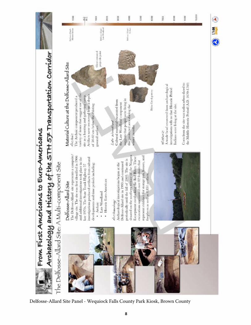
The Delfosse-Allard site represents a campsite/village site. The site was firstidentified in 1906 and additional investigations took place in the late 1970s. TheState Trunk Highway 57 investigations produced artifacts from culturaldevelopments and time periods including:
• Archaic• Late Woodland• Historic Euro-American
Archaeology
Archaeological investigations began at the Delfosse-Allard site in 1993 andcontinued periodically until the fall of 2003. The site is situated on the southernterrace of the Niagara Escarpment overlooking the Red River. Theseexcavations uncovered over 82 features that represent evidence for storagepits, houses, and fireplaces as well as 8,851 artifacts.
Overview photo of excavtion of test unit Partially excavated feature
Material Culture at the Delfosse-Allard Site
Archaic
The Archaic component produced a variety of items that suggest use of the siteas a hunting and gathering camp. Artifacts were recovered from a depth of 50-60 cm below the existing ground surface.
Late Woodland
Cultural material excavated from the Late Woodland component suggests thatpeople were living in this protected area during the winter months.
Historic
A trade bead recovered from archaeological investigations tells us that HistoricPeriod Indians were living at the site. Corn from the site was radiocarbon datedto the Middle Historic Period (A.D. 1670-1760)
Overview
ArchaeologicalSites
Beaudhuin Village
Fabry Creek (BossTavern)
Christoff
Delfosse-Allard
Heyrman I
Holdorf
VandermissenBrickworks
Williamsonville
��
3/7/11 9:17 AM - Mar 7, 2011STH 57 Project: 1992-2008 - Delfosse-Allard Site
Page 2 of 2http://archaeolab.anthro.uwm.edu/STH_57_Project/delfosse.html
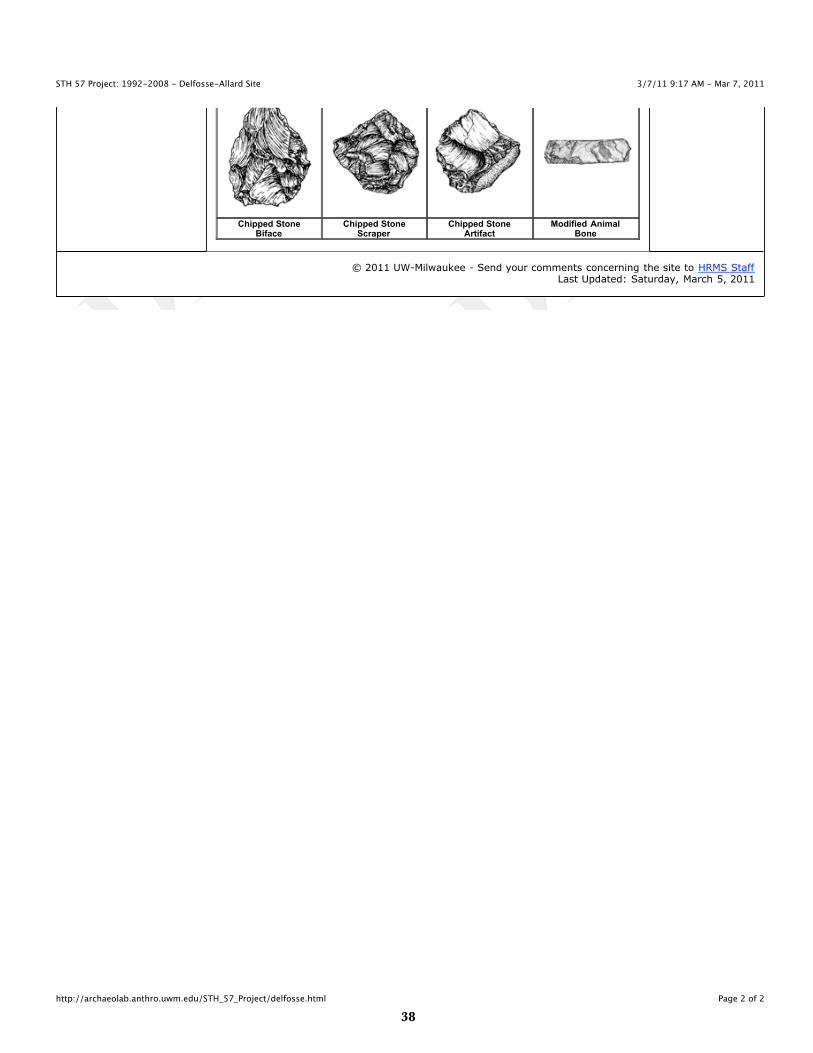
Chipped StoneBiface
Chipped StoneScraper
Chipped StoneArtifact
Modified AnimalBone
© 2011 UW-Milwaukee - Send your comments concerning the site to HRMS StaffLast Updated: Saturday, March 5, 2011
��
3/7/11 9:17 AM - Mar 7, 2011STH 57 Project: 1992-2008 - Heyrman I Site
Page 1 of 2http://archaeolab.anthro.uwm.edu/STH_57_Project/heyrman1.html
Project Navigation
Home
Project Overview
Environment
Cultural History
Reports
Links
Overview
ArchaeologicalSites
Beaudhuin Village
Fabry Creek (BossTavern)
Christoff
Delfosse-Allard
Heyrman I
Holdorf
VandermissenBrickworks
Williamsonville
Archaeology, State Trunk Highway 57,and the Door Peninsula
Heyrman I Site
The Heyrman I site represents a campsite and stone tool workshop occupiedalmost continuously from Paleoindian to Historic Euro-American times.
The Heyrman I site was situated on a long, narrow saddle-shaped sand ridge,parallel to the original State Trunk Highway 57. The ridge is part of the sameancient lake terrace system that harbored the archaeological deposits at thenearby Fabry Creek (Boss Tavern) site.
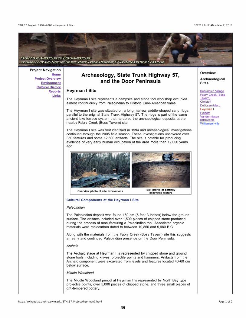
The Heyrman I site was first identified in 1994 and archaeological investigationscontinued through the 2005 field season. These investigations uncovered over350 features and some 12,500 artifacts. The site is notable for producingevidence of very early human occupation of the area more than 12,000 yearsago.
Overview photo of site excavationsSoil profile of partially
excavated feature
Cultural Components at the Heyrman I Site
Paleoindian
The Paleoindian deposit was found 160 cm (5 feet 3 inches) below the groundsurface. The artifacts included over 1,500 pieces of chipped stone producedduring the process of manufacturing a Paleoindian tool. Associated organicmaterials were radiocarbon dated to between 10,860 and 9,980 B.C.
Along with the materials from the Fabry Creek (Boss Tavern) site this suggestsan early and continued Paleoindian presence on the Door Peninsula.
Archaic
The Archaic stage at Heyrman I is represented by chipped stone and groundstone tools including knives, projectile points and hammers. Artifacts from theArchaic component were excavated from levels and features located 40-60 cmbelow surface.
Middle Woodland
The Middle Woodland period at Heyrman I is represented by North Bay typeprojectile points, over 5,000 pieces of chipped stone, and three small pieces ofgrit-tempered pottery.
�0
3/7/11 9:17 AM - Mar 7, 2011STH 57 Project: 1992-2008 - Heyrman I Site
Page 2 of 2http://archaeolab.anthro.uwm.edu/STH_57_Project/heyrman1.html
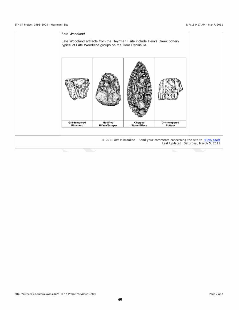
Late Woodland
Late Woodland artifacts from the Heyrman I site include Hein’s Creek potterytypical of Late Woodland groups on the Door Peninsula.
Grit-temperedRimsherd
ModifiedBiface/Scraper
ChippedStone Biface
Grit-temperedPottery
© 2011 UW-Milwaukee - Send your comments concerning the site to HRMS StaffLast Updated: Saturday, March 5, 2011
��
3/7/11 9:17 AM - Mar 7, 2011STH 57 Project: 1992-2008 - Holdorf Site
Page 1 of 2http://archaeolab.anthro.uwm.edu/STH_57_Project/holdorf.html
Project Navigation
Home
Project Overview
Environment
Cultural History
Reports
Links
Archaeology, State Trunk Highway 57,and the Door Peninsula
Holdorf Site
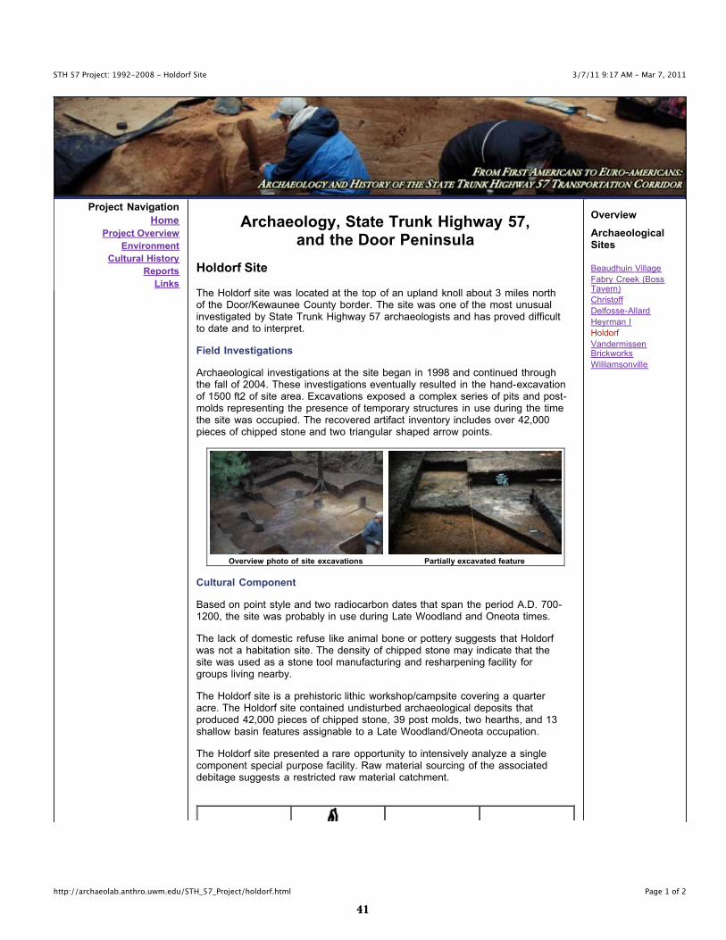
The Holdorf site was located at the top of an upland knoll about 3 miles northof the Door/Kewaunee County border. The site was one of the most unusualinvestigated by State Trunk Highway 57 archaeologists and has proved difficultto date and to interpret.
Field Investigations
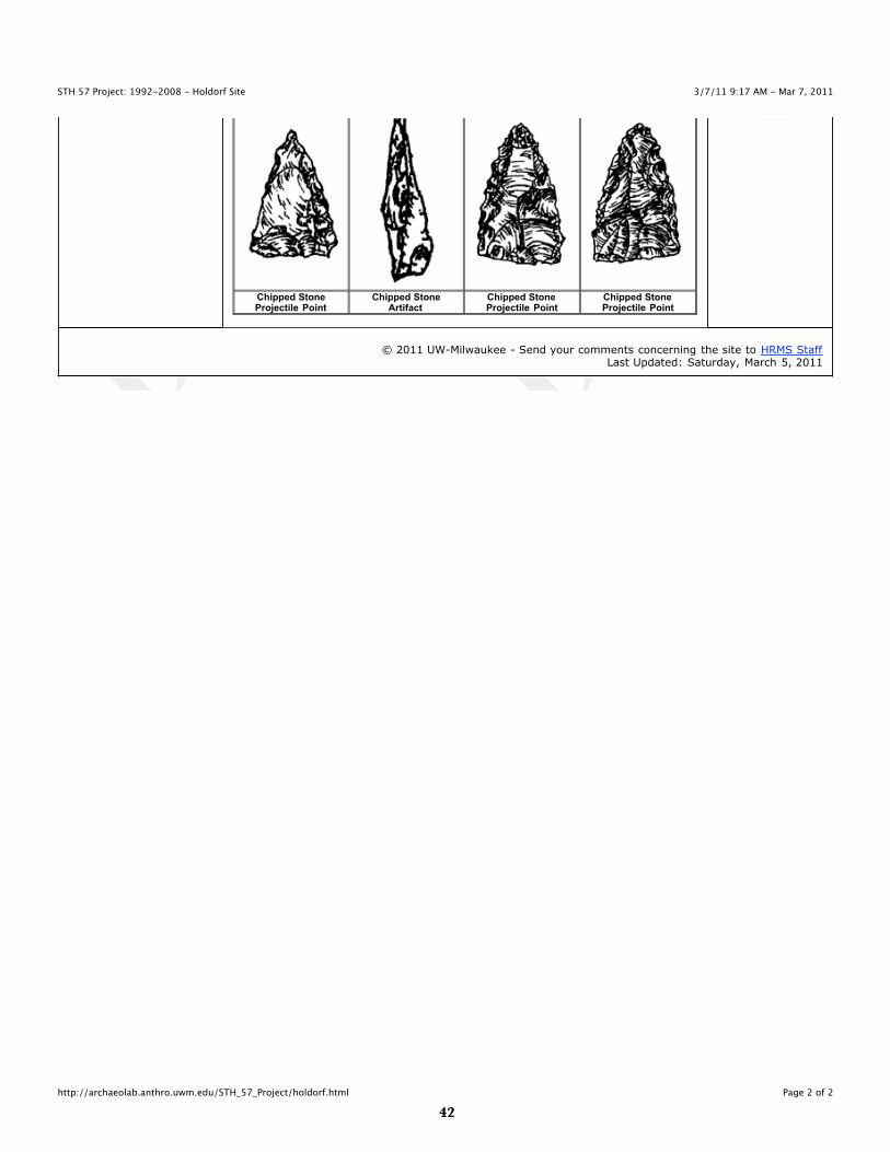
Archaeological investigations at the site began in 1998 and continued throughthe fall of 2004. These investigations eventually resulted in the hand-excavationof 1500 ft2 of site area. Excavations exposed a complex series of pits and post-molds representing the presence of temporary structures in use during the timethe site was occupied. The recovered artifact inventory includes over 42,000pieces of chipped stone and two triangular shaped arrow points.
Overview photo of site excavations Partially excavated feature
Cultural Component
Based on point style and two radiocarbon dates that span the period A.D. 700-1200, the site was probably in use during Late Woodland and Oneota times.
The lack of domestic refuse like animal bone or pottery suggests that Holdorfwas not a habitation site. The density of chipped stone may indicate that thesite was used as a stone tool manufacturing and resharpening facility forgroups living nearby.
The Holdorf site is a prehistoric lithic workshop/campsite covering a quarteracre. The Holdorf site contained undisturbed archaeological deposits thatproduced 42,000 pieces of chipped stone, 39 post molds, two hearths, and 13shallow basin features assignable to a Late Woodland/Oneota occupation.
The Holdorf site presented a rare opportunity to intensively analyze a singlecomponent special purpose facility. Raw material sourcing of the associateddebitage suggests a restricted raw material catchment.
Overview
ArchaeologicalSites
Beaudhuin Village
Fabry Creek (BossTavern)
Christoff
Delfosse-Allard
Heyrman I
Holdorf
VandermissenBrickworks
Williamsonville
��
3/7/11 9:17 AM - Mar 7, 2011STH 57 Project: 1992-2008 - Holdorf Site
Page 2 of 2http://archaeolab.anthro.uwm.edu/STH_57_Project/holdorf.html
Chipped StoneProjectile Point
Chipped StoneArtifact
Chipped StoneProjectile Point
Chipped StoneProjectile Point
© 2011 UW-Milwaukee - Send your comments concerning the site to HRMS StaffLast Updated: Saturday, March 5, 2011
��
3/7/11 9:18 AM - Mar 7, 2011STH 57 Project: 1992-2008 - Vandermissen Brickworks
Page 1 of 2http://archaeolab.anthro.uwm.edu/STH_57_Project/vandermissen.html
Project Navigation
Home
Project Overview
Environment
Cultural History
Reports
Links
Archaeology, State Trunk Highway 57,and the Door Peninsula
Vandermissen Brickworks Site
What does the Vandermissen Brickworks site represent?
On October 8th 1871, the Peshtigo fire jumped across Green Bay from themainland to the Door Peninsula destroying many of the Belgian farms and smalltowns along the west side of the Door Peninsula.
The Belgians rebuilt after the fire using bricks instead of logs for construction. Ahousehold brick making industry developed to produce the bricks. Many of thesedistinctive red brick structure survive today and give the region its architecturalcharacter.
The Vandermissen Brickworks was operated as early as 1899 and ceasedoperation between 1905 and 1917. Other small brickworks in operation duringthis time include the Macco Brickworks to the south in Kewaunee County andthe G. Peters Brickworks located northeast of Vandermissen.
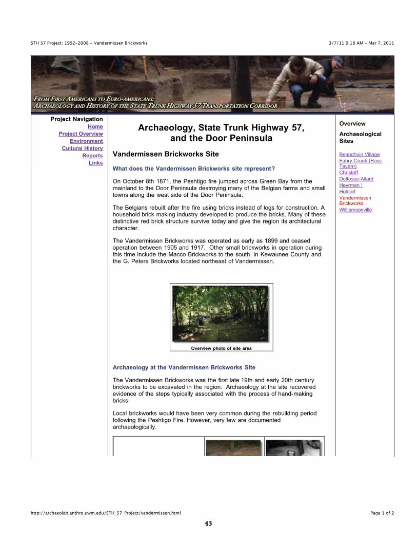
Overview photo of site area
Archaeology at the Vandermissen Brickworks Site
The Vandermissen Brickworks was the first late 19th and early 20th centurybrickworks to be excavated in the region. Archaeology at the site recoveredevidence of the steps typically associated with the process of hand-makingbricks.
Local brickworks would have been very common during the rebuilding periodfollowing the Peshtigo Fire. However, very few are documentedarchaeologically.
Overview
ArchaeologicalSites
Beaudhuin Village
Fabry Creek (BossTavern)
Christoff
Delfosse-Allard
Heyrman I
Holdorf
VandermissenBrickworks
Williamsonville

��
3/7/11 9:18 AM - Mar 7, 2011STH 57 Project: 1992-2008 - Vandermissen Brickworks
Page 2 of 2http://archaeolab.anthro.uwm.edu/STH_57_Project/vandermissen.html
Historic Well Historic Brick Clamp Historic Pug Mill
© 2011 UW-Milwaukee - Send your comments concerning the site to HRMS StaffLast Updated: Saturday, March 5, 2011
��
3/7/11 9:18 AM - Mar 7, 2011STH 57 Project: 1992-2008 - Williamsonville Site
Page 1 of 2http://archaeolab.anthro.uwm.edu/STH_57_Project/williamsonville.html
Project Navigation
Home
Project Overview
Environment
Cultural History
Reports
Links
Archaeology, State Trunk Highway 57,and the Door Peninsula
The Town of Williamsonville and the Williamsonville Site
Tornado Memorial Park in Door County is located on the site of the formersettlement of Williamsonville. The town was settled by the Williamson family in1869 to take advantage of the newly built state road that linked Red River andSturgeon Bay.
By 1871, Williamsonville had a steam powered shingle mill for processing woodfrom the nearby pine forests and cedar swamps, a boarding house, ablacksmith shop, eight houses, and 10 acres of cleared farmland. The town’spopulation of 76 included men, women, and children.
The Fire
On October 8, 1871 events conspired to erase Williamsonville from thelandscape if not from memory. Contemporary accounts tell us
“the woods and the heavens were all on fire, thesmoke blocked the sun and the rising moon turned
red.”
This fire, known as the Peshtigo Fire, is less known than the Chicago Firewhich occurred on the same day. The Peshtigo fire destroyed 1,000,000 acresof farms, forests, sawmills, and small towns in Wisconsin and Upper Michigan,including the town of Williamsonville. It remains the most destructive forest firein American history.
For 10 days prior to October 8, 1871, residents of Williamsonville had beenfighting small fires and setting back-fires to protect their town. Despite theseefforts, a strong wind began to blow on the evening of October 8, fanning firesand spreading sparks and eventually burning all of Williamsonville’s buildings.People took shelter in a potato patch north of the town, the town well, andunder wet blankets in beds of ash. Fifty nine of the town’s 76 residents died aswell as 16 horses, five oxen, and 38 hogs. The settlement of Williamsonvillewas never rebuilt.
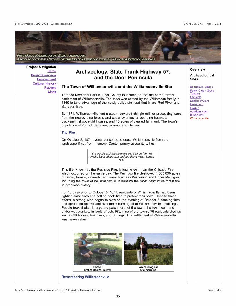
Phase Iarchaeological survey
Archaeologicalsite mapping
Remembering Williamsonville
Overview
ArchaeologicalSites
Beaudhuin Village
Fabry Creek (BossTavern)
Christoff
Delfosse/Allard
Heyrman I
Holdorf
VandermissenBrickworks
Williamsonville
��
3/7/11 9:18 AM - Mar 7, 2011STH 57 Project: 1992-2008 - Williamsonville Site
Page 2 of 2http://archaeolab.anthro.uwm.edu/STH_57_Project/williamsonville.html
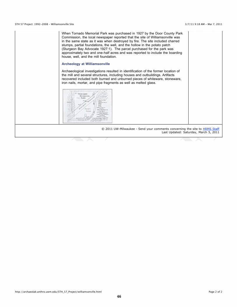
When Tornado Memorial Park was purchased in 1927 by the Door County ParkCommission, the local newspaper reported that the site of Williamsonville wasin the same state as it was when destroyed by fire. The site included charredstumps, partial foundations, the well, and the hollow in the potato patch(Sturgeon Bay Advocate 1927:1). The parcel purchased for the park wasapproximately two and one-half acres and was reported to include the boardinghouse, well, and the mill foundation.
Archeology at Williamsonville
Archaeological investigations resulted in identification of the former location ofthe mill and several structures, including houses and outbuildings. Artifactsrecovered included both burned and unburned pieces of whiteware, stoneware,iron nails, mortar, and pipe fragments as well as melted glass.
© 2011 UW-Milwaukee - Send your comments concerning the site to HRMS StaffLast Updated: Saturday, March 5, 2011
��
3/7/11 9:16 AM - Mar 7, 2011STH 57 Project: 1992-2008 - Reports
Page 1 of 1http://archaeolab.anthro.uwm.edu/STH_57_Project/reports.html
Project Navigation
Home
Project Overview
Environment
Cultural History
Reports
Links
Reports
Links to Culture Resource Management Reports
The following is a list of reports documenting the archaeological investigations conducted alongthe State Trunk Highway 57 project corridor. These include the following:
Weston, G.M., E.D. Benchley, B. Nansel, and R. Brubaker1994 Interim Report of Investigations of the State Highway 57 Improvement Project,Brown and Kewaunee Counties, Wisconsin. University of Wisconsin-MilwaukeeArchaeological Research Laboratory Reports of Investigations No. 120. Report preparedfor Wisconsin Department of Transportation. (PDF 4.2MB)
Weston, G.M., E.D. Benchley, and C.A. Koster1996 Final Report of Archaeological Investigations at the State Highway 57/59Interchange Improvement Project, Brown County, Wisconsin. University of Wisconsin-Milwaukee Archaeological Research Laboratory Reports of Investigations No. 127. Reportprepared for Wisconsin Department of Transportation. (PDF 10.1MB)
Richards, P. B. and J. D. Richards2005 Transportation Archaeology on the Door Peninsula: Progress and Prospects 1992 -2004. Archaeological Research Lab Report of Investigations 157. (PDF 22.9MB)
Nicholls, B.D. and J. D. Richards2007 Archaeological Monitoring along the STH 57 Project Corridor, Door County,Wisconsin. Archaeological Research Lab Report of Investigations 162. (PDF 8.3MB)
Nicholls, B.D. and J. D. RichardsArchaeological Monitoring along the STH 57 Project Corridor, Door County, Wisconsin:Summary Review. Archaeological Research Lab Report of Investigations 163. (PDF32.3MB)
Nicholls, B.D. and J. D. RichardsArchaeological Monitoring along the STH 57 Project Corridor, Door County, Wisconsin:2007 - 2008 Summary Review. Archaeological Research Lab Report of Investigations166. (PDF 8.4MB)
© 2011 UW-Milwaukee - Send your comments concerning the site to HRMS StaffLast Updated: Monday, March 7, 2011
��
3/7/11 9:16 AM - Mar 7, 2011STH 57 Project: 1992-2008
Page 1 of 1http://archaeolab.anthro.uwm.edu/STH_57_Project/projlinks.html
Project Navigation
Home
Project Overview
Environment
Cultural History
Reports
Links
Archaeology, State Trunk Highway 57,and the Door Peninsula
Project Links
WisDOT Forms
Section 106 Review, Archaeological/Historical Information - Form DT1635 (Word)Archaeological Survey Field Report (ASFR) - Form DT1978 (Word)Arcaheological Literature and Records Review - Form DT1459 (Word)
Wisconsin Historical Society Forms and Documents
Guide to Wisconsin's Archaeological Forms - (PDF)
Wisconsin Determination of Eligibility Form - (Word)Wisconsin Public Lands Field Archaeology Permit - (PDF) (Word)Bibliography of Archaeological Report - BAR Form - (PDF) (Word)Wisconsin Archaeological Site Inventory (ASI) Form - (PDF) (Word)Wisconsin Archaeological Site Inventory (ASI) Short Form - (PDF) (Word)Wisconsin Archaeological Site Inventory (ASI) Update Form - (PDF) (Word)
Burial Sites Report Form - (PDF)
Wisconsin NRHP Registration Form (NPS FORM 10-900) - (Word)
Other Important Documents
WAS Guidelines for Public Archaeology in Wisconsin (1997) - (PDF 1300 k)National Park Service NRHP Registration Form (NPS Form 10-900) (PDF)
© 2011 UW-Milwaukee - Send your comments concerning the site to HRMS StaffLast Updated: Monday, February 28, 2011
��
STH 57 PuBlIC INTERPRETATION WEquIOCK FAllS COuNTy PARK KIOSK PANEl WEBSITE
- DRAFT -

�0
3/7/11 10:59 AM - Mar 7, 2011Public Interpretation for the STH 57 Project
Page 1 of 1http://archaeolab.anthro.uwm.edu/STH_57_Project/STH57_Public_Interpretation/Index.html
Project NavigationState Trunk Highway 57 Website
Project Documents
Panels in Each
Introduction
Timeline
Cultural History Panel
Wequiock Falls Kiosk Panels
Delfosse-Allard
Holdorf and Christoff
Heyrman I
Fabry Creek (Boss Tavern)
Beaudhuin Village
CTH C Park & Ride KioskPanels
Historic Settlement
The Fire of 1871 and
Williamsonville
After the Fire: The Vandermissen
Brickworks
Those Who Perished at
Williamsonville during the Peshtigo
Fire
State Trunk Highway 57 Project: Public Interpretation
The following pages provide information pertaining to the public interpretation of thearchaeological findings along the State Trunk Highway 57 (STH 57) project within Brown,Kewaunee and Door Counties.
The table below represents 8.5" x 11" files of the panels proposed to be displayed at theWequiock Falls Park kiosk in Brown County and CTH C Park & Ride kiosk in Door County.Each of the files are in jpeg format.
Two options for viewing the panels are available.
Option 1 - 8.5" x 11" Panel Image, will open the panel image up to a full 8." x 11" image.Option 2 - will direct you to the individual panel websites.
Wequiock Falls Park Kiosk - Brown County
Panel 8.5" x 11" Panel Image SizePanelPage
STH 57 Project Introduction - *Present at both kiosks Project Intro 1.0 MB Web Page
STH 57 Project Timeline - *Present at both kiosks Project Timeline 1.3 MB Web Page
Cultural Traditions Identified along the STH 57 ProjectCorridor - *Present at both kiosks
Cultural Traditions 1.2 MB Web Page
Delfosse-Allard Site Delfiosse-Allard 0.9 MB Web Page
Holdorf and Christoff Sites Holdorf & Christoff 1.2 MB Web Page
Heyrman I Site Heyrman I 1.1 MB Web Page
Fabry Creek (Boss Tavern) Site Fabry Creek (Boss Tavern) 0.8 MB Web Page
Beaudhuin Village Site Beaudhuin Village 1.2 MB Web Page
CTH C Park & Ride Kiosk - Door County
Panel 8.5" x 11" Panel Image Size Web Page
STH 57 Project Introduction - *Present at both kiosks Project Intro 1.0 MB Web Page
STH 57 Project Timeline - *Present at both kiosks Project Timeline 1.3 MB Web Page
Cultural Traditions Identified along the STH 57 ProjectCorridor - *Present at both kiosks
Cultural Traditions1.2 MB Web Page
Historic Settlement of the Door Peninsula Historic Settlement 1.1 MB Web Page
Belgian Community following the Peshtigo Fire Belgian Community 1.3 MB Web Page
Vandermissen Brickworks Site Vandermissen Brickworks 1.2 MB Web Page
A List of those Who Perished at Williamsonville during thePeshtigo Fire
The Perished atWilliamsonville
0.6 MB Web Page
© 2011 UW-Milwaukee - Send your comments concerning the site to HRMS StaffLast Updated: Monday, March 7, 2011

��
3/6/11 10:06 PM - Mar 6, 2011STH Project Introduction
Page 1 of 1http://archaeolab.anthro.uwm.edu/STH_57_Project/STH57_Public_Interpretation/Project_Introduction.html
Project NavigationState Trunk Highway 57 Website
Project Documents
Panels in Each
Introduction
Timeline
Cultural History Panel
Wequiock Falls Kiosk Panels
Delfosse-Allard
Holdorf and Christoff
Heyrman I
Fabry Creek (Boss Tavern)
Beaudhuin Village
CTH C Park & Ride KioskPanels
Historic Settlement
The Fire of 1871 and
Williamsonville
After the Fire: The Vandermissen
Brickworks
Those Who Perished at
Williamsonville during the Peshtigo
Fire
Introduction
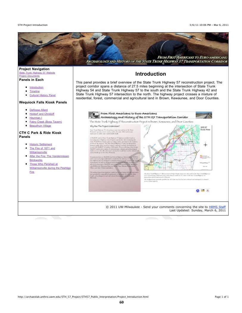
This panel provides a brief overview of the State Trunk Highway 57 reconstruction project. Theproject corridor spans a distance of 27.5 miles beginning at the intersection of State TrunkHighway 54 and State Trunk Highway 57 to the south and the State Trunk Highway 42 andState Trunk Highway 57 intersection to the north. The highway project crosses a mixture ofresidential, forest, commercial and agricultural land in Brown, Kewaunee, and Door Counties.
© 2011 UW-Milwaukee - Send your comments concerning the site to HRMS StaffLast Updated: Sunday, March 6, 2011
��
3/6/11 10:06 PM - Mar 6, 2011STH 57 Project Timeline
Page 1 of 1http://archaeolab.anthro.uwm.edu/STH_57_Project/STH57_Public_Interpretation/Project_Timeline.html
Project NavigationState Trunk Highway 57 Website
Project Documents
Panels in Each
Introduction
Timeline
Cultural History Panel
Wequiock Falls Kiosk Panels
Delfosse-Allard
Holdorf and Christoff
Heyrman I
Fabry Creek (Boss Tavern)
Beaudhuin Village
CTH C Park & Ride KioskPanels
Historic Settlement
The Fire of 1871 and
Williamsonville
After the Fire: The Vandermissen
Brickworks
Those Who Perished at
Williamsonville during the Peshtigo
Fire
Timeline
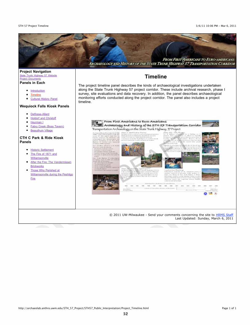
The project timeline panel describes the kinds of archaeological investigations undertakenalong the State Trunk Highway 57 project corridor. These include archival research, phase Isurvey, site evaluations and data recovery. In addition, the panel describes archaeologicalmonitoring efforts conducted along the project corridor. The panel also includes a projecttimeline.
© 2011 UW-Milwaukee - Send your comments concerning the site to HRMS StaffLast Updated: Sunday, March 6, 2011

��
3/6/11 10:06 PM - Mar 6, 2011Culture History along STH 57
Page 1 of 1http://archaeolab.anthro.uwm.edu/STH_57_Project/STH57_Public_Interpretation/Cultural_History.html
Project NavigationState Trunk Highway 57 Website
Project Documents
Panels in Each
Introduction
Timeline
Cultural History Panel
Wequiock Falls Kiosk Panels
Delfosse-Allard
Holdorf and Christoff
Heyrman I
Fabry Creek (Boss Tavern)
Beaudhuin Village
CTH C Park & Ride KioskPanels
Historic Settlement
The Fire of 1871 and
Williamsonville
After the Fire: The Vandermissen
Brickworks
Those Who Perished at
Williamsonville during the Peshtigo
Fire
Cultural History
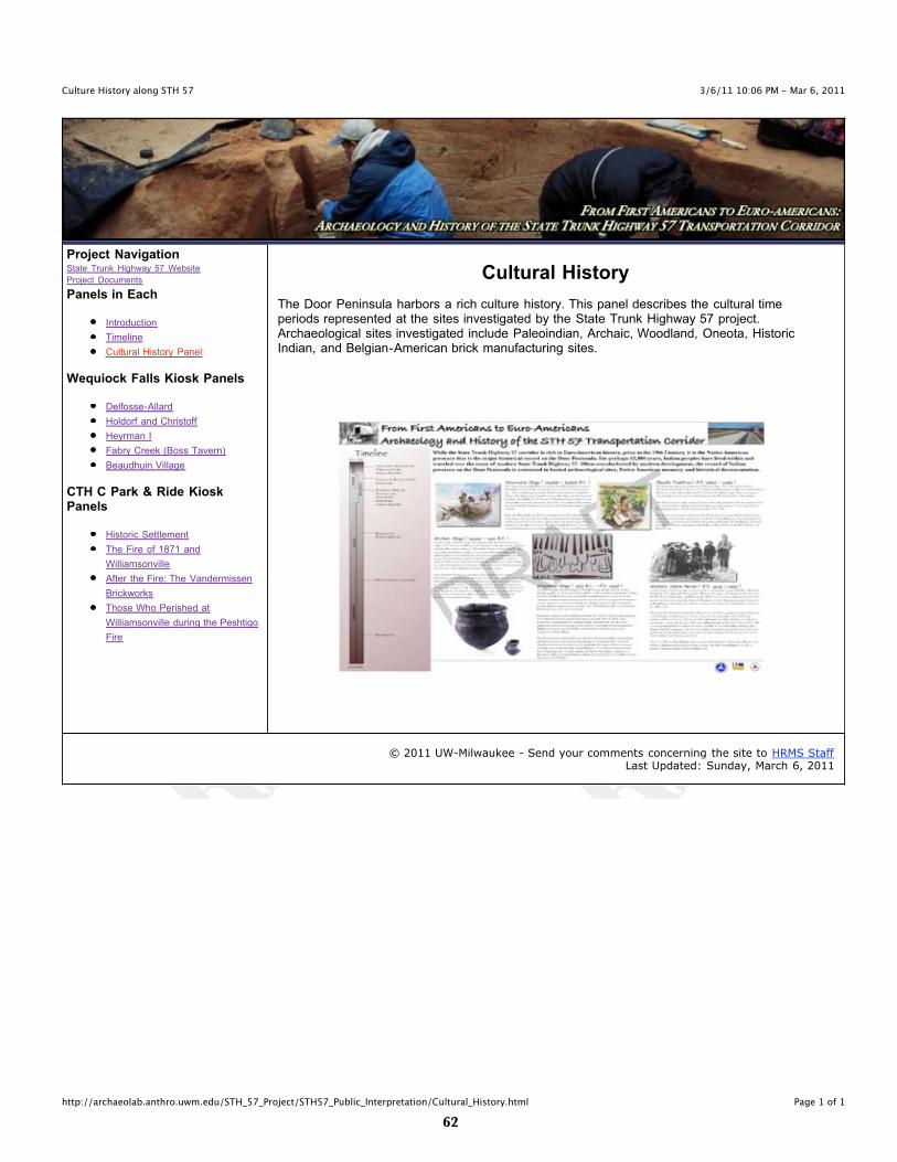
The Door Peninsula harbors a rich culture history. This panel describes the cultural timeperiods represented at the sites investigated by the State Trunk Highway 57 project.Archaeological sites investigated include Paleoindian, Archaic, Woodland, Oneota, HistoricIndian, and Belgian-American brick manufacturing sites.
© 2011 UW-Milwaukee - Send your comments concerning the site to HRMS StaffLast Updated: Sunday, March 6, 2011
��
3/6/11 10:07 PM - Mar 6, 2011The Delfosse/Allard Site
Page 1 of 1http://archaeolab.anthro.uwm.edu/STH_57_Project/STH57_Public_Interpretation/DelfosseAllard.html
Project NavigationState Trunk Highway 57 Website
Project Documents
Panels in Each
Introduction
Timeline
Cultural History Panel
Wequiock Falls Kiosk Panels
Delfosse-Allard
Holdorf and Christoff
Heyrman I
Fabry Creek (Boss Tavern)
Beaudhuin Village
CTH C Park & Ride KioskPanels
Historic Settlement
The Fire of 1871 and
Williamsonville
After the Fire: The Vandermissen
Brickworks
Those Who Perished at
Williamsonville during the Peshtigo
Fire
The Delfosse-Allard Site
A Multi-Component Site
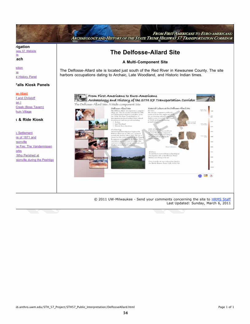
The Delfosse-Allard site is located just south of the Red River in Kewaunee County. The siteharbors occupations dating to Archaic, Late Woodland, and Historic Indian times.
© 2011 UW-Milwaukee - Send your comments concerning the site to HRMS StaffLast Updated: Sunday, March 6, 2011
��
3/6/11 10:07 PM - Mar 6, 2011Holdorf and Christoff Sites
Page 1 of 1http://archaeolab.anthro.uwm.edu/STH_57_Project/STH57_Public_Interpretation/HoldorfChristoff.html
Project NavigationState Trunk Highway 57 Website
Project Documents
Panels in Each
Introduction
Timeline
Cultural History Panel
Wequiock Falls Kiosk Panels
Delfosse-Allard
Holdorf and Christoff
Heyrman I
Fabry Creek (Boss Tavern)
Beaudhuin Village
CTH C Park & Ride KioskPanels
Historic Settlement
The Fire of 1871 and
Williamsonville
After the Fire: The Vandermissen
Brickworks
Those Who Perished at
Williamsonville during the Peshtigo
Fire
The Holdorf and Christoff Sites
A Chipped Stone Workshop and a Prehistoric Campsite
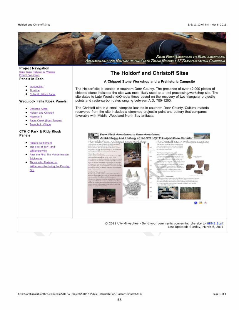
The Holdorf site is located in southern Door County. The presence of over 42,000 pieces ofchipped stone indicates the site was most likely used as a tool processing/workshop site. Thesite dates to Late Woodland/Oneota times based on the recovery of two triangular projectilepoints and radio-carbon dates ranging between A.D. 700-1200.
The Christoff site is a small campsite located in southern Door County. Cultural materialrecovered from the site includes a stemmed projectile point and pottery that comparesfavorably with Middle Woodland North Bay artifacts.
© 2011 UW-Milwaukee - Send your comments concerning the site to HRMS StaffLast Updated: Sunday, March 6, 2011
��
3/6/11 10:07 PM - Mar 6, 2011The Heyrman I Site
Page 1 of 1http://archaeolab.anthro.uwm.edu/STH_57_Project/STH57_Public_Interpretation/Heyrman.html
Project NavigationState Trunk Highway 57 Website
Project Documents
Panels in Each
Introduction
Timeline
Cultural History Panel
Wequiock Falls Kiosk Panels
Delfosse-Allard
Holdorf and Christoff
Heyrman I
Fabry Creek (Boss Tavern)
Beaudhuin Village
CTH C Park & Ride KioskPanels
Historic Settlement
The Fire of 1871 and
Williamsonville
After the Fire: The Vandermissen
Brickworks
Those Who Perished at
Williamsonville during the Peshtigo
Fire
The Heyrman I Site
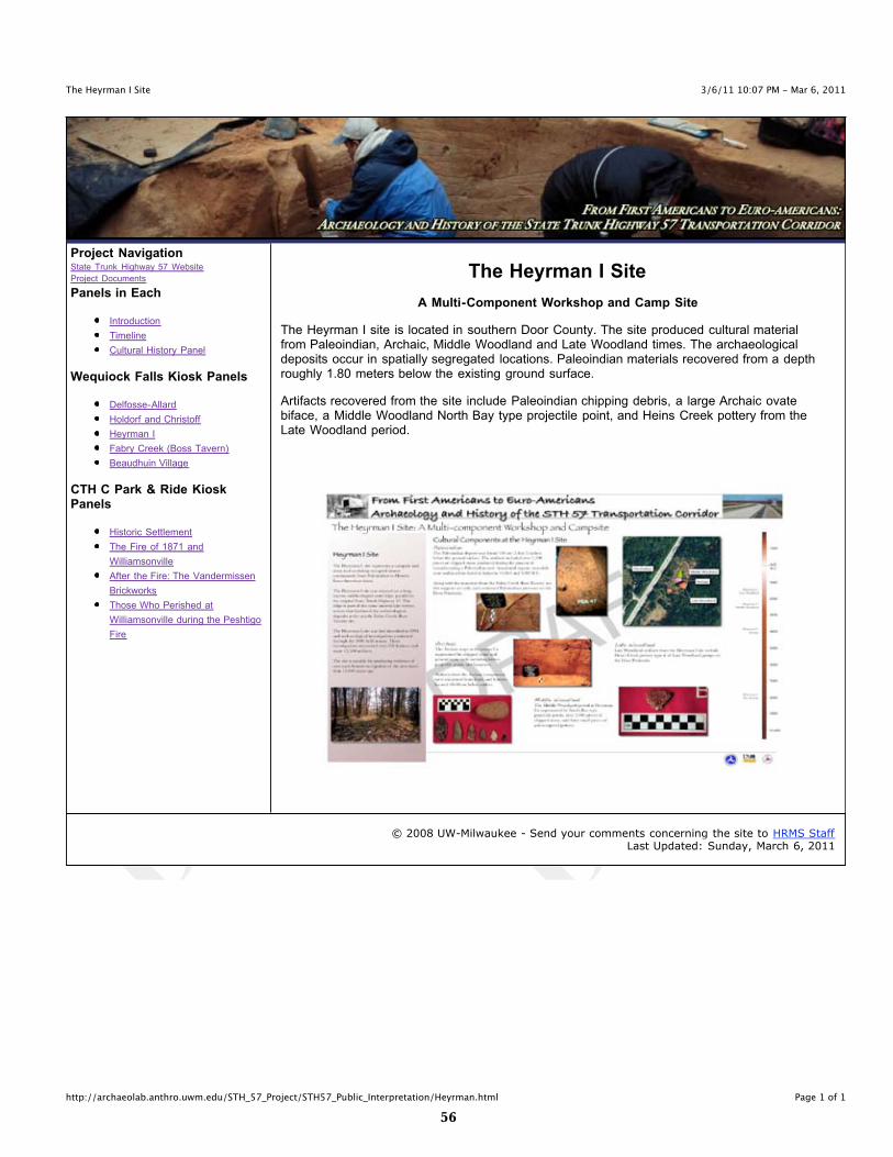
A Multi-Component Workshop and Camp Site
The Heyrman I site is located in southern Door County. The site produced cultural materialfrom Paleoindian, Archaic, Middle Woodland and Late Woodland times. The archaeologicaldeposits occur in spatially segregated locations. Paleoindian materials recovered from a depthroughly 1.80 meters below the existing ground surface.
Artifacts recovered from the site include Paleoindian chipping debris, a large Archaic ovatebiface, a Middle Woodland North Bay type projectile point, and Heins Creek pottery from theLate Woodland period.
© 2008 UW-Milwaukee - Send your comments concerning the site to HRMS StaffLast Updated: Sunday, March 6, 2011
��
3/6/11 10:07 PM - Mar 6, 2011The Fabry Creek (Boss Tavern) Site
Page 1 of 1http://archaeolab.anthro.uwm.edu/STH_57_Project/STH57_Public_Interpretation/FabryCreekBossTavern.html
Project NavigationState Trunk Highway 57 Website
Project Documents
Panels in Each
Introduction
Timeline
Cultural History Panel
Wequiock Falls Kiosk Panels
Delfosse-Allard
Holdorf and Christoff
Heyrman I
Fabry Creek (Boss Tavern)
Beaudhuin Village
CTH C Park & Ride KioskPanels
Historic Settlement
The Fire of 1871 and
Williamsonville
After the Fire: The Vandermissen
Brickworks
Those Who Perished at
Williamsonville during the Peshtigo
Fire
Fabry Creek (Boss Tavern) Site
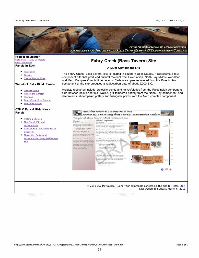
A Multi-Component Site
The Fabry Creek (Boss Tavern) site is located in southern Door County. It represents a multi-component site that produced cultural material from Paleoindian, North Bay Middle Woodlandand Mero Complex Oneota time periods. Carbon samples recovered from the Paleoindiancomponent at the site produced a radiocarbon date of about 9,000 B.C.
Artifacts recovered include projectile points and knives/blades from the Paleoindian component,side-notched points and thick walled, grit-tempered pottery from the North Bay component, anddecorated shell-tempered pottery and triangular points from the Mero complex component.
© 2011 UW-Milwaukee - Send your comments concerning the site to HRMS StaffLast Updated: Sunday, March 6, 2011
��
3/6/11 10:07 PM - Mar 6, 2011The Beaudhuin Village Site
Page 1 of 1http://archaeolab.anthro.uwm.edu/STH_57_Project/STH57_Public_Interpretation/BeaudhuinVillage.html
Project NavigationState Trunk Highway 57 Website
Project Documents
Panels in Each
Introduction
Timeline
Cultural History Panel
Wequiock Falls Kiosk Panels
Delfosse-Allard
Holdorf and Christoff
Heyrman I
Fabry Creek (Boss Tavern)
Beaudhuin Village
CTH C Park & Ride KioskPanels
Historic Settlement
The Fire of 1871 and
Williamsonville
After the Fire: The Vandermissen
Brickworks
Those Who Perished at
Williamsonville during the Peshtigo
Fire
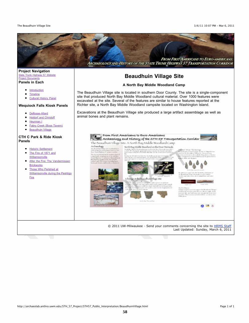
Beaudhuin Village Site
A North Bay Middle Woodland Camp
The Beaudhuin Village site is located in southern Door County. The site is a single-componentsite that produced North Bay Middle Woodland cultural material. Over 1000 features wereexcavated at the site. Several of the features are similar to house features reported at theRichter site, a North Bay Middle Woodland campsite located on Washington Island.
Excavations at the Beaudhuin Village site produced a large artifact assemblage as well asanimal bones and plant remains.
© 2011 UW-Milwaukee - Send your comments concerning the site to HRMS StaffLast Updated: Sunday, March 6, 2011
��
STH 57 PuBlIC INTERPRETATION CTH C PARK & RIDE KIOSK PANEl WEBPAGES
- DRAFT -
�0
3/6/11 10:06 PM - Mar 6, 2011STH Project Introduction
Page 1 of 1http://archaeolab.anthro.uwm.edu/STH_57_Project/STH57_Public_Interpretation/Project_Introduction.html
Project NavigationState Trunk Highway 57 Website
Project Documents
Panels in Each
Introduction
Timeline
Cultural History Panel
Wequiock Falls Kiosk Panels
Delfosse-Allard
Holdorf and Christoff
Heyrman I
Fabry Creek (Boss Tavern)
Beaudhuin Village
CTH C Park & Ride KioskPanels
Historic Settlement
The Fire of 1871 and
Williamsonville
After the Fire: The Vandermissen
Brickworks
Those Who Perished at
Williamsonville during the Peshtigo
Fire
Introduction
This panel provides a brief overview of the State Trunk Highway 57 reconstruction project. Theproject corridor spans a distance of 27.5 miles beginning at the intersection of State TrunkHighway 54 and State Trunk Highway 57 to the south and the State Trunk Highway 42 andState Trunk Highway 57 intersection to the north. The highway project crosses a mixture ofresidential, forest, commercial and agricultural land in Brown, Kewaunee, and Door Counties.
© 2011 UW-Milwaukee - Send your comments concerning the site to HRMS StaffLast Updated: Sunday, March 6, 2011

��
3/6/11 10:06 PM - Mar 6, 2011STH 57 Project Timeline
Page 1 of 1http://archaeolab.anthro.uwm.edu/STH_57_Project/STH57_Public_Interpretation/Project_Timeline.html
Project NavigationState Trunk Highway 57 Website
Project Documents
Panels in Each
Introduction
Timeline
Cultural History Panel
Wequiock Falls Kiosk Panels
Delfosse-Allard
Holdorf and Christoff
Heyrman I
Fabry Creek (Boss Tavern)
Beaudhuin Village
CTH C Park & Ride KioskPanels
Historic Settlement
The Fire of 1871 and
Williamsonville
After the Fire: The Vandermissen
Brickworks
Those Who Perished at
Williamsonville during the Peshtigo
Fire
Timeline
The project timeline panel describes the kinds of archaeological investigations undertakenalong the State Trunk Highway 57 project corridor. These include archival research, phase Isurvey, site evaluations and data recovery. In addition, the panel describes archaeologicalmonitoring efforts conducted along the project corridor. The panel also includes a projecttimeline.
© 2011 UW-Milwaukee - Send your comments concerning the site to HRMS StaffLast Updated: Sunday, March 6, 2011
��
3/6/11 10:06 PM - Mar 6, 2011Culture History along STH 57
Page 1 of 1http://archaeolab.anthro.uwm.edu/STH_57_Project/STH57_Public_Interpretation/Cultural_History.html
Project NavigationState Trunk Highway 57 Website
Project Documents
Panels in Each
Introduction
Timeline
Cultural History Panel
Wequiock Falls Kiosk Panels
Delfosse-Allard
Holdorf and Christoff
Heyrman I
Fabry Creek (Boss Tavern)
Beaudhuin Village
CTH C Park & Ride KioskPanels
Historic Settlement
The Fire of 1871 and
Williamsonville
After the Fire: The Vandermissen
Brickworks
Those Who Perished at
Williamsonville during the Peshtigo
Fire
Cultural History
The Door Peninsula harbors a rich culture history. This panel describes the cultural timeperiods represented at the sites investigated by the State Trunk Highway 57 project.Archaeological sites investigated include Paleoindian, Archaic, Woodland, Oneota, HistoricIndian, and Belgian-American brick manufacturing sites.
© 2011 UW-Milwaukee - Send your comments concerning the site to HRMS StaffLast Updated: Sunday, March 6, 2011

��
3/7/11 1:18 PM - Mar 7, 2011Historic Settlement
Page 1 of 1http://archaeolab.anthro.uwm.edu/STH_57_Project/STH57_Public_Interpretation/Historic_Settlement.html
Project NavigationState Trunk Highway 57 Website
Project Documents
Panels in Each
Introduction
Timeline
Cultural History Panel
Wequiock Falls Kiosk Panels
Delfosse-Allard
Holdorf and Christoff
Heyrman I
Fabry Creek (Boss Tavern)
Beaudhuin Village
CTH C Park & Ride KioskPanels
Historic Settlement
The Fire of 1871 and
Williamsonville
After the Fire: The Vandermissen
Brickworks
Those Who Perished at
Williamsonville during the Peshtigo
Fire
Historic Euro-American Settlement of the Door Peninsula
The historic Euro-American and Belgian settlement panel provides a brief overview of Historicperiod Euro-American settlement on the Door Peninsula. The panel highlights the Belgiansettlement of eastern Door County.
© 2011 UW-Milwaukee - Send your comments concerning the site to HRMS StaffLast Updated: Monday, March 7, 2011
��
3/7/11 1:23 PM - Mar 7, 2011The Williamsonville Site
Page 1 of 1http://archaeolab.anthro.uwm.edu/STH_57_Project/STH57_Public_Interpretation/Williamsonville.html
Project NavigationState Trunk Highway 57 Website
Project Documents
Panels in Each
Introduction
Timeline
Cultural History Panel
Wequiock Falls Kiosk Panels
Delfosse-Allard
Holdorf and Christoff
Heyrman I
Fabry Creek (Boss Tavern)
Beaudhuin Village
CTH C Park & Ride KioskPanels
Historic Settlement
The Fire of 1871 and
Williamsonville
After the Fire: The Vandermissen
Brickworks
Those Who Perished at
Williamsonville during the Peshtigo
Fire
Williamsonville
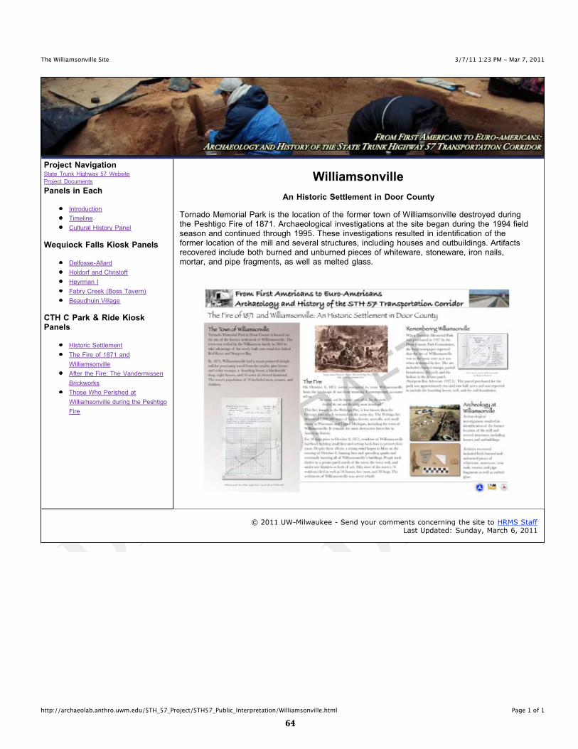
An Historic Settlement in Door County
Tornado Memorial Park is the location of the former town of Williamsonville destroyed duringthe Peshtigo Fire of 1871. Archaeological investigations at the site began during the 1994 fieldseason and continued through 1995. These investigations resulted in identification of theformer location of the mill and several structures, including houses and outbuildings. Artifactsrecovered include both burned and unburned pieces of whiteware, stoneware, iron nails,mortar, and pipe fragments, as well as melted glass.
© 2011 UW-Milwaukee - Send your comments concerning the site to HRMS StaffLast Updated: Sunday, March 6, 2011
��
3/7/11 1:32 PM - Mar 7, 2011The Vandermissen Brickworks Site
Page 1 of 1http://archaeolab.anthro.uwm.edu/STH_57_Project/STH57_Public_Interpretation/VandermissenBW.html
Project NavigationState Trunk Highway 57 Website
Project Documents
Panels in Each
Introduction
Timeline
Cultural History Panel
Wequiock Falls Kiosk Panels
Delfosse-Allard
Holdorf and Christoff
Heyrman I
Fabry Creek (Boss Tavern)
Beaudhuin Village
CTH C Park & Ride KioskPanels
Historic Settlement
The Fire of 1871 and
Williamsonville
After the Fire: The Vandermissen
Brickworks
Those Who Perished at
Williamsonville during the Peshtigo
Fire
After the Fire: The Vandermissen Brickworks
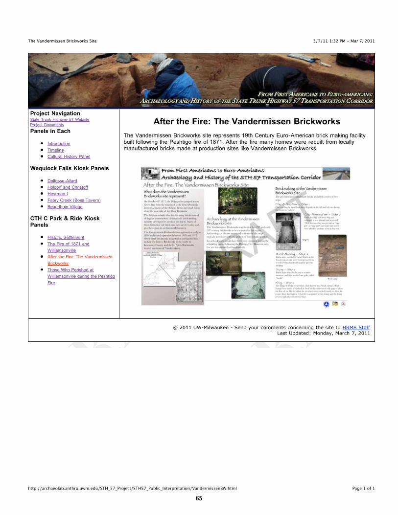
The Vandermissen Brickworks site represents 19th Century Euro-American brick making facilitybuilt following the Peshtigo fire of 1871. After the fire many homes were rebuilt from locallymanufactured bricks made at production sites like Vandermissen Brickworks.
© 2011 UW-Milwaukee - Send your comments concerning the site to HRMS StaffLast Updated: Monday, March 7, 2011
��
3/6/11 10:22 PM - Mar 6, 2011Williamsonville
Page 1 of 1http://archaeolab.anthro.uwm.edu/STH_57_Project/STH57_Public_Interpretation/WilliamsonvillePerished.html
Project NavigationState Trunk Highway 57 Website
Project Documents
Panels in Each
Introduction
Timeline
Cultural History Panel
Wequiock Falls Kiosk Panels
Delfosse-Allard
Holdorf and Christoff
Heyrman I
Fabry Creek (Boss Tavern)
Beaudhuin Village
CTH C Park & Ride KioskPanels
Historic Settlement
The Fire of 1871 and
Williamsonville
After the Fire: The Vandermissen
Brickworks
Those Who Perished at
Williamsonville during the Peshtigo
Fire
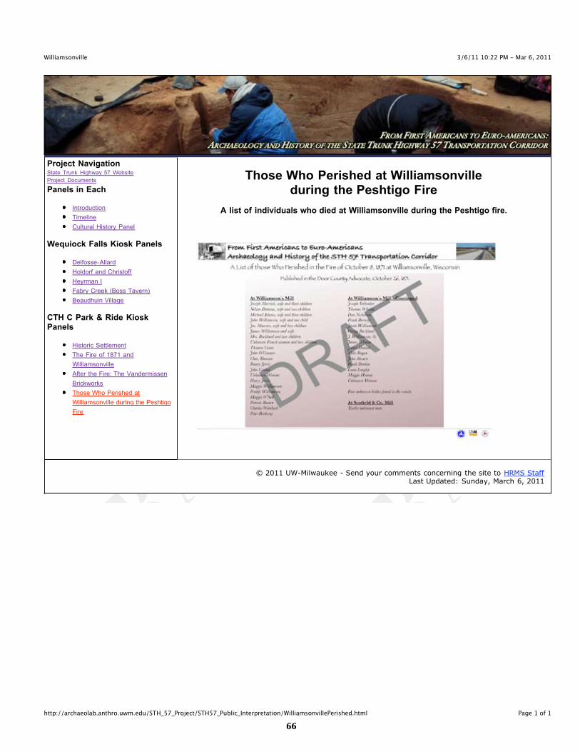
Those Who Perished at Williamsonvilleduring the Peshtigo Fire
A list of individuals who died at Williamsonville during the Peshtigo fire.
© 2011 UW-Milwaukee - Send your comments concerning the site to HRMS StaffLast Updated: Sunday, March 6, 2011