stor/:~:: --- --- -- .. .- -. national seashore
TRANSCRIPT

- ---._----.--., -------~-- ~.- - -'-,-.--- _._.' _.-' ~
I~'!
STOR/:~::
\';1 LtJ E IiN!5S
D -/j, A
JAI. T MAR.SH
Interpretive
ProspectusOM MICROfILM
DAY USE:CAMPr;Rou~JD /' '" \ \
fORT / .- /' '\ '\/ 110AIlOWALi< "'.- '" / " "'\
-- ~ .._--- .-" ... - ----------_._-- ---_.----- -.
SCANNEDr!)-()/02-
GULF ISLANDS
NATIONAL SEASHORE

II•IJ..
IIItII'II•IIIII1I•
INTERPRETIVE PROSPECTUS
GULF ISLANDS NATIONAL SEASHORE
FEBRUARY 1979
L. Clifford SoubierHarpers Ferry Center
(Approved by Acting Regional Director, Charles E. Watson, bymemorandum of February 16, 1979)

II•IJ
.'
~I
IIII1·1I.IJIII1I•
LEGISLATIVE COMPLIANCE
All action proposed in this plan must comply with the provisions of
Section 106 of the 1966 Historic Preservation Act and Executive
Order 11593 as codified in the Procedures of the Advisory Council
on Historic Presel~vation (36 CFR Part 800) .. Prior to a decision to
impl ement any provi s ions of thi s plan, these procedures reaui re tha t
all cultural resources in or near the project areas must be identified
and evaluated in terms of the National Register Criteria of Eligibility.
The evaluation must be done by the Regional Director in consultation
with the State HIstoric Preservation Officer. Additionally, the
Criteria for Adverse Effect (36 CFR Part 800.8 and 800.9) must be
applied by the Regional Director in consultation \·,ith the State
Historic Preservation Officer and the Advisory Council Procedures
completed as appropriate.

1I•IJIIIII
,1I•IIIIIII•
Summary of Proposals
Introduct; on
The Resource
Theme
Visitors
The Plan
Naval Live Oaks
Santa Rosa Area
Pensaco1a Forts
Perdi do Key
Fort Pickens
Davis Bayou
West Ship Island
Planning Team
TABLE OF CONTENTS
PAGE
2
2
4
4
4
6
6
7
8
12
13
16
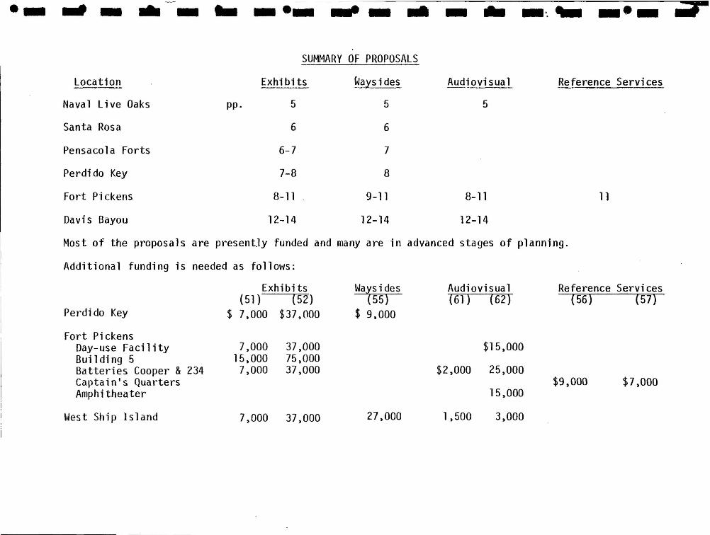
·- .. - .. - .. _.- ... - .. - .. -'..... _.- .,.SUMMARY OF PROPOSALS
Location Exhi bits Waysides
Naval Live Oaks pp. 5 5
Santa Rosa 6 6
Pensacola Forts 6-7 7
Perdi do Key 7-8 8
Fort Pi ckens 8-11 9-11
Davis Bayou 12-14 12-14
Audiovisual
5
8-11
12-14
Reference Services
11
Most of the proposals are presently funded and many are in advanced stages of planning.
Additional funding is needed as follows:
Perdido Key
Exhibits(51) (52)
$ 7,000 $37,000
watsides55)
$ 9,000
Audiovisual(6]) (62)
Reference Services( 56) (57)
7,000 37,000
$15,000
$2,000 25,000
15,000
Fort Pi ckensDay-use FacilityBuil di ng 5Batteries Cooper &234Captainls QuartersAmphitheater
West Ship Island
7,00015,0007,000
37,00075,00037,000
27,000 1,500 3,000
$9,000
I•I
JIIIII1IIIIII1I•
Introduction
A preliminary Interpretive Prospectus for Gulf Islands was prepared
in 1973 by the Firm of Reynolds, Smith, and Hills, but was not
approved. Since that time, planning of numerous facilities has
proceeded and interpretive planning has been provided on an ad hoc
basis. This writer attended meetings November 1977 with personnel
of the National Seashore, Regional Office, Denver Service Center,
and the aforementioned architectural firm, largely for the purpose
of assigning interpretive functions to the Davis Bayou and Naval Live
Oaks Visitor Centers. A similar meeting occurred in March 1978, to
reach an agreement on concepts for the Santa Rosa and Pensacola Forts
Areas. This plan, therefore, is partly for the purpose of filling in
after the fact and documenting consensus on portions of the national
seashore already in advanced stages of planning. In addition, the
remainder of the national seashore will be considered in sufficient
detail that, it is hoped, this document will resemble a full park
Interpretive Prospectus.
A decision following the November meeting which has implications for
the entire national seashore concerns audiovisual produ~tions.
There will be a movie, primarily for use at the Davis Bayou Area, on
the subject of the Gulf Coast ecosystem. A slide program on Gulf
Islands in general will be of use in all units for basic familiarization
and for off-site. A movie will be produced which focuses on the
evolution of seacoast fortifications. All three will be usable
throughout the national seashore, and off-site, in varying degrees.

I•IJ
."
IIIIIIIIIIItI1I•
The Resource
The string of barrier islands which comprise Gulf Islands provides
a combined total of over 100 miles of shoreline offering wide,
gently-sloping beaches of fine white sand and clear, blue-green
water combined with a mild climate.
The predominant resources for public use and enjoyment are
recreational. The national seashore also includes natural and
cultural resources, including a wilderness area, worthy of preserva
tion and interpretation. The island/mainland relationship provides
habitats for ecosystems of esthetic and economic value to man, and
the strategic importance of harbors embraced by the islands has
engendered a rich historical resource embodying the full story of
seacoast defense.
Theme
The offshore islands of the Gulf Coast shelter lagoons and marshes
which are important habitats for a rich variety of marine life.
From the earliest settlement by Europeans, these islands were likewise
perceived as protection for the major ports and great river systems
which empty into the gulf. Forts at a few strategic points easily
controlled entry. The barrier islands thus are aptly named; they
form a barrier to natural forces and to human endeavors.
In both spheres a balance is maintained by such barriers. In terms
of the natural scene, the balance creates a safe harbor for sea life
at a delicate stage of development. But nature is not static in form;
2

I•I
JIIItI1IIIIII1I•
only the forces are constant, a fact particularly noticeable on
the Gulf Coast where islands shift constantly. It is the relative
rapidity of change and movement which provokes notice. To say that
all things change is to state what is obvious -- and therefore un
perceived. Confronted daily with the uncertainties of human affairs,
we are inclined to view the natural world, including the cycle of
seasons, as comfortably steady. (Doubtless this is one of the great
attractions of parks). It is something of a shock to view a
phenomenon like Ship Island, where build-up of the shore has left
Fort Massachusetts (the human reference point) a considerable distance
from its strategic location. Such movement is part of the natural
pattern of the coast; a change in the islandls shape does not change
its fundamental character.
In the human sphere, however, things have moved more rapidly. Prior
to the 20th Century, harbor defense was severely restricted by
geography and the technology of the times, just as dependence on
natural materials for shipbuilding made the live oaks important.
Masonry fortifications had lost their utility long before Ship Island
shifted and before Fort McRee sank into the bay off Perdido Key.
Metal ships, airplanes, and finally missiles have largely eliminated
the limitations which determined the area's military significance.
ManIs ability to eliminate natural barriers, often beyond nature's
capacity to adjust to such changes, has had enormous impact on the
coastal environment, even threatening to destroy resources which
3

,I•IJII
I II
itII111
II.IItI1I•
attracted settlement .
It1s our turn to protect the barriers.
Visitors
Visitors to Gulf Islands are predominantly seeking recreational
opportunities, with a large proportion of local, repeat use. There
is, however, a percentage of visitors with more specific interests,
such as the forts. As has already been observed at Fort Pickens,
many come for the beach and become interested in other resources
and activities. This tendency, coupled with the fact that the park
is so widely dispersed even local visitors may be unaware of oppor
tunities in other units, leads to the conclusion that three levels of
public contact are indicated. (1) Through cooperation with State
authorities, orientation publications should be obtainable on
Interstate 10. (2) At major entry or assembly points of the park,
a very brief orientation to the park as a whole is needed, along with
information to opportunities at hand. (3) Deeper interpretation of
resource in a given unit, usually provided at a point removed from
function #2.
Recommendations for facilities and programs follow, by location.
Naval Live Oaks
The Naval Live Oaks Reservation is a site of the first order of
significance in the history of the conservation of national resources
in the United States. Until the development of iron warships, live
oak timber was regarded as a resource absolutely vital to national
defense.
4

1I.'IJ
.'
III
I~~I
'1I1IIJItI
11I•
In 1828, the United States purchased the 1,337.87 acres comprising
the present Naval Live Oaks Reservation, the first of numerous
tracts set aside to assure a continued supply of naval timber.
The same year, President John Quincy Adams authorized the establish
ment on the Reservation of the first, and only, federal tree farm or
plantation.
Maps at the information desk and in introductory exhibits will orient
visitors to the inmediate vicinity and relate the Naval Live Oak,S Area to
Gulf Islands National Seashore as a whole.
Exhibits will deal with the historic use of the oaks, both as raw
material and finished product. Historic diagrams showing how
portions of the trees lent themselves to 19th Century shipbuilding
along with specimen of the material would be fehtured.
The building will be adjacent to a significant shell midden. Early
occupancy'will be interpreted within the center as well as with,
wayside exhibits on the trail.
The auditorium will be provided with both movie and sound/slide
equipment to take advantage of any of the programs presently
conceived for the park as a whole, and for special programs.
Major on-site interpretation of the live oaks will be via wayside
exhibits about 1,000 feet west of the Visitor Center. Exact choice
of location will hopefully take advantage of trees which can help
illustrate the live-oak plantation operation, i.e., choice of trees
5
1I•II~JI II
!~
:1,I1I•IJItI1I•
with potential for certain parts of a ship. The General Development
Plan also calls for four other shelter/overlooks on the self-guided
trail system.
Santa Rosa Area
The recently completed day-use facility includes a room for public
contact which will mainly serve as an adjunct to recreational
activities and to dispense information about other units of the park.
Existing information and exhibit facilities will be supplemented with
colorful banners, mood photos, and changing exhibits featuring local
artists. A wayside exhibit on the overpass to the beach will briefly
acquaint visitors with the rationale for the type of development here,
. i.e., clustered development to minimize impact on the dunes. A small
exhibit adjacent to the visitor contact station, looking toward the
ranger residence, will explain the solar water heating equipment
therein. A wayside exhibit on the boardwalk will interpret the
dunes which the walk passes over, and the purpose of the boardwalks.
The newly acquired Okaloosa Area.requires something to identify it as
part of the National Seashore. The wayside exhibit planner will
examine the area for inclusion of an exhibit relating the unit to
the seashore.
Pensacola Forts
Contact stations will be constructed at Fort Barrancas and at Advanced
Redoubt. Access to the interior of Fort Barrancas and the Water
Battery will be by guided tour only. In addition to providing
restrooms, the contact stations will be an assembly point for guided
6~~--- ---
~,
I•I
JI~
ItI1IIJItI1I•
tours as well as the starting point for self-guided access at Redoubt.
In addition to relating basic reasons why the forts were built, visitors
need to be apprised of two main points at the outset: (1) the relation
ship between Fort Barrancas and Redoubt, and (2) the relationship between
the Pensacola fortifications and the other two points of harbor defense
which constituted the triangular system: Fort Pickens on Santa Rosa
Island and Fort McRee on Perdido Key. Protection from land attack was
included in the system.
Fort Barrancas requires an exhibit on the third system of fortifications
and a brief photo-essay on soldier life, and a small display of artifacts.
Wayside exhibits at a few key points around the forts convey some basic
information about functions of various architectural features, for the
benefit of self-guided visitors, and reinforce the overall harbor defense
theme. A publication will be needed to provide more detail.
To aid the guided tours, large "flash cards", hand or easel held, will
be provided. These can be stored at various points along the route
inside the fort and pulled out to illustrate the narrative.
Perdi do Key
A day-use facility will be constructed, with contact station, along the
lines of the Santa Rosa facility. Some orientation to the national
seashore as a whole would be useful for visitors using this portion of
it. Visitation is predominately local, but highly transitory,
necessitating frequent re-education.
Orientation to immediate resources will include reference to Fort McRee.
7
:,,I•I
JI~
I,I1JIJItI1I•
The biggest resource management problem at Perdido Key is use of 4-wheel
drive vehicles. Here is an opportunity for interpretation to aid
significantly in Resource Management. Interpretation will emphasize
the recreationist's vital role in assuring the continued vitality of
dunes and related resources, perhaps through photos of dune destruction
and its consequences. The theme should be presented in a positive
manner, addressing the visitor as one who would surely not engage in
such activities against his own interests.
The platform at the marsh area merits a wayside exhibit interpreting
the importance of marshlands, along the lines of the theme at Davis
Bayou.
Access to the histpric zone is limited; however, a wayside exhibit
is warranted for the benefit of those who reach this point.
Fort Pickens
A beach day-use facility, similar to that in the Santa Rosa Area will
be constructed in the Fort Pickens Area. The contact station within
will require only such interpretation as will tell visitors about
activities in the vicinity and the unit's place in Gulf Islands
National Seashore.
Building Five, a T-shaped structure ca. 1900, presently serves for
administrative headquarters and interpretation. With some alteration
of Building Five, it could serve quite well for expanded interpretive
use. An audiovisual room will be required for the film dealing with
coast fortifications, as well as other programs as needed.
8
,I•I
:J~
I~
I1I1IIJItI1I•
Generally, history interpretation, other than the moyie t will be
handled on-site at various fort structures. Exhibits in Building
Five will deal with natural history, although one exhibit about the
fort itself would be useful to provoke interest in the fort tour,
and to connect the fort thematically with the natural story as
formulated in the theme statement. Subjects for Natural History
exhibits are:
Hurricanes change the shape and size of barrier islands
by moving huge amounts of sand.
Plants and animals adapt to drought, sandy and salty
conditions on barrier islands by camouflage, by
avoiding the hot sun, and by moving in special ways.
Fort Pi ckens: Coasta1 Defense. II It woul d be appropri ate to note
that even the first Spanish settlers recognized that control of the
island and the bluffs across the channel was essential for control
of the harbor, one of the best natural ports of the Gulf Coast.
Even though the structures and their precise locations changed over
time, the defense theory did not. When the United States began
fortification of the harbor in 1829, the Army built Pickens on the
9
,I
I.
I III
:~'.
I II
~
I1II1I•IJIII1I•
island, Barrancas on the bluffs, and McRee on Perdido Key, thus
creating virtually impregnable triangulation of cross-fire."
(Quoted from Preliminary Interpretive Prospectus, by Reynolds,
Smith, and Hills, 1973).
Wayside exhibits (about four, initially) will expand interpretation
of Fort Pickens to encompass the Spanish period through World War II.
Battery Cullum/Sevier encompasses more than one period of fortification,
consequently some of the evolution of coastal forts can be interpreted
here. This battery contains two useable ammunition lifts, which
might be put into operation.
The disappearing gun and shield guns at Batteries Cooper and 234 are
among the few remaining of such pieces and warrant considerable
attention. This complex of fortification and armament (including the
observation tower) are an extraordinary historic scene, and great care
must be exercised to protect its integrity. This should be born in
mind if any additional development takes place here, such as extending
parking. Two rooms in Battery Cooper are adaptable for exhibit and
audiovisual use to interpret the function of both the disappearing
gun and the shield guns, with a short audiovisual program utilizing
actual footage of the guns in operation. Exhibits would deal with
the range of the guns and photos of the wartime scene at this or
similar installations. An interesting footnote would be an exhibit
on World War II scrap drives, which sealed the fate of most of the
great guns. Humidity control will be required for both exhibit and AV
and furnished areas, and will need to be manned for protection .
10
1I•I
J..
III1I1I•IJItI1I•
A wayside exhibit plan will be required to coordinate interpretation
of the military structures on the tour. Approximately six wayside
exhibits will be required in addition to those mentioned above for
Fort Pickens proper. These will include natural history interpreta
tion, with subjects appropriate to the central theme, such as the
shifting of the island and changes in ecosystems engendered by man's
work.
Battery Langdon presents a problem or opportunity, depending on the
point of view. Being the first military structure encountered in
approaching Fort Pickens, it can be a bit of a puzzle to the un
initiated. The wayside exhibit which describes its function, although
adequate in itself, does not convey much to anyone totally unfamiliar
with such bunkers and coast fortifications. A wayside exhibit cannot
encompass the whole story, although it might be treated as a "tickler ll,
hinting at the general story which can be learned. If it is determined
that a visitor center is needed in the future, the battery would make
an intriguing one, with the large front opening glassed in.
Captains Quarters - For the purpose of interpreting post life, the
Captains Quarters should be furnished ca. 1930 as a background for
living history, providing interpretation of one of the "between wars"
periods. Most of the history of such installations consisted of
maintaining a token of military preparedness, which really amounted
to unpreparedness. A furnishings plan will be needed.
Amphitheater - A more adequate screen and projection booth will be
provided for the campground amphitheater .
11
1I•I
J.'
I~~
I1I1IIJItI1I•
Davis Bayou
The visitor center for the Mississippi District will be located near
a representative remnant of marsh environment which once characterized
the now highly developed Biloxi-Gulfport area, and which is a morsel
of the nursery for the gulf fisheries. Interpretation will revolve
around this highly important resource, which owes its existence to
the barrier islands, and extend to the island/mainland protective
rel ati onshi p.
A movie will carry much of the burden of interpreting the inter
dependence, productivity, vulnerability, and relationships among the
inhabitants of bayou, sound, and barrier island. The main exhibit
will consist of a diagrammatic mural showing the aquatic env.ironment
augmented with mounted specimens, models, photos, etc. The exhibit
will introduce the visitor to the complex interrelationships of bayou
and offshore island ecology.
The secondary function of the visitor center will be to orient visitors
to the national seashore as a whole, as well as to the immediate
resources. This will be accomplished through personal services, maps,
and publications.
A self-guiding trail beginning at the visitor center will expose the
visitor first-hand to the marsh environment. Wayside exhibits will
relate the off-shore islands to the mainland environment as well as
deal with the resources at hand.
12
1I•IJIIIII1I•IJIII1I•
West Ship Island
Most visitors to West Ship Island will be heading for the beach,
where a day-use facility will be constructed. As in the case of
the Santa Rosa facility, the public contact room will serve as an
adjunct to recreational activities and to dispense information about
other units of the seashore. A boardwalk from the dock will fork at
an observation tower, one path leading to Fort Massachusetts (and
then to the shore, with dune crossing), the other to the day-use
facility. A wayside exhibit at the junction will give a brief
account of the fort and schedul e of fort tours. A boatload at
once is too many for a tour, but if visitors are aware of tour
times, it ;s no imposition to return to the fort in the course of
a day at the beach. If heavy use warrants, it might be advisable
to have some sort of sign-up system, limited to a reasonable tour
number, at this point.
Wayside exhibits on the boardwalk, especially at the dune crossings,
will interpret the island1s natural history and accomplish a
preservation goal by pointing out to visitors why foot traffic is
regulated in this manner.
Fort Massachusetts. The French were the first to grasp the strategic
importance of Ship Island. An expedition launched for the purpose
of establishing a colony near the mouth of the Mississippi River
located a base camp in 1699 on the east end of Ship Island to take
advantage of the natural deep water harbor. The island also dominated
the channel giving access to the Gulf Coast and New Orleans, con-
13

,I•I
J..
IIIII1I•IIIII,I•
sequently its military significance continued to be recognized, and
construction of the present fort was begun in 1859. Although the
exterior walls were finished in 1870, the Civil War had proved the
obsolescence of masonry forts, and the fort was never completed .
The fort will be interpreted largely on a self-guided basis augmented
with personal services. However, some introductory visual aids would
help to establish some points which are difficult to convey on the
tour. One of the casemates would serve as an assembly area with such
things as engineer's drawings, a map showing the area from New Orleans
to Pensacola to set the fort in its functional relation to the land,
and an illustration of the difference between smooth-bore and rifled
cannon. The usefulness of the fort was directly related to the
effective range of the guns. Research is under wayan the fort's
use as a Confederate Prisoner of War camp. Proper placement of the
United Daughters of the Confederacy plaques will be determined by
the results of this research.
An observation tower is to be constructed from which visitors will
be able to see the other islands, as well as getting a better grasp
of the shifting shoreline. An audio message, augmented by identifying
pointers, will interpret features visible from the tower.
Some of the non-military history of the island warrants interpretation.
Until the Gulfport harbor was constructed in 1901, Ship Island remained
an important port, primarily as an anchoring point for exportation of
Yellow Pine from the central Gulfport region. At one point, a yellow
14

,I•I
JI'I~!
IItI1I•IIIII1I•
fever quarantine station functioned here. Interpretation of these
matters could be handled by wayside exhibits if historic photographs
could be located.
15

,I•IJ..
IIIII
II,,I.IIII~1
I•
Planning Team
Gulf Islands National SeashoreFranklin O. Pridemore, SuperintendentNoel J. Pachta, Assistant SuperintendentMary Dodd, Chief of Interpretation
Southeast Regional OfficeNorman Bishop, Chief Naturalist
Harpers Ferry CenterKip Stowell, Division of ExhibitsJames Mulcahy, Division of ExhibitsBrian Jones, Division of Audiovisual ArtsTom Kleiman, Division of Audiovisual ArtsRay Price, Division of Wayside ExhibitsBill Brown, Division of Reference ServicesL. Clifford Soubier, Division of Interpretive Planning
16