storm drainage report - pickering€¦ · storm drainage report 1.0 introduction in support of the...
TRANSCRIPT

Appendix F Storm Drainage and Stormwater Management Evaluation Report
Storm Drainage Report
STORM DRAINAGE AND STORMWATER MANAGEMENT EVALUATION
SCHEDULE ‘C’ MUNICIPAL CLASS ENVIRONMENTAL ASSESSMENT
HIGHWAY 401 CROSSING NOTION ROAD/SQUIRES BEACH ROAD
CITY OF PICKERING
Prepared By: Sabourin Kimble & Associates Ltd.
Prepared For: Pickering Developments Inc. and City of Pickering
Project Number: 13:302
Date: October 10, 2019
Storm Drainage Report
TABLE OF CONTENTS
1.0 INTRODUCTION ............................................................................................................................. 1
2.0 STUDY AREA .................................................................................................................................. 1
3.0 PREFERRED DESIGN CONCEPT ...................................................................................................... 1
4.0 STORM DRAINAGE ........................................................................................................................ 3
4.1 Existing Storm Drainage Characteristics ....................................................................................... 3
4.1.1 Squires Beach Road ................................................................................................................... 3
4.1.2 Notion Road .............................................................................................................................. 3
4.2 Proposed Storm Drainage Works .................................................................................................. 6
4.2.1 Squires Beach Road ................................................................................................................... 6
4.2.2 Notion Road .............................................................................................................................. 6
5.0 STORMWATER MANAGEMENT CRITERIA .......................................................................................... 9
5.1 Water Quality Control ................................................................................................................... 9
5.2 Erosion Control ............................................................................................................................. 9
5.3 Water Quantity Control ................................................................................................................ 9
5.4 Water Balance ............................................................................................................................... 9
6.0 POSSIBLE STORMWATER MANAGEMENT WORKS ....................................................................... 9
6.1 Squires Beach Road ........................................................................................................................... 10
6.2 Notion Road ...................................................................................................................................... 12
7.0 FLOODPLAIN CONSIDERATIONS .................................................................................................. 13
8.0 CONCLUSIONS ............................................................................................................................. 17
Storm Drainage Report
TABLE OF FIGURES
Figure 1: Study Area .................................................................................................................. 2
Figure 2: Preferred Design Concept Plan and Profile ................................................ Back Pocket
Figure 3: Existing Drainage – Squires Beach Road .................................................................... 4
Figure 4: Existing Drainage – Notion Road ................................................................................ 5
Figure 5: Proposed Drainage – Squires Beach Road ................................................................. 7
Figure 6: Proposed Drainage – Notion Road .............................................................................. 8
Figure 7: Typical LID Geometry - Notion Road/Squires Beach Road…………………………… 11
Figure 8: Preferred Road Alternative – Relative Increase in Flood Levels Regional Storm – Steady Condtions..........................................................................15
Figure 9: Preferred Road Alternative – Relative Increase in Flood Levels Regional Storm – Unsteady Conditions .....................................................................16
1
Storm Drainage Report
1.0 INTRODUCTION
In support of the Schedule ‘C’ Municipal Class Environmental Assessment for the new Highway 401 crossing from Notion Road to Squires Beach Road, this report has been prepared in conjunction with the Environmental Study Report and addresses storm drainage, stormwater management and floodplain impacts. The report summarizes the existing drainage characteristics for each road right-of-way, required revisions to the existing storm drainage works to support the preferred design concept, existing storm drainage outlets and their impact on the storm drainage and/or stormwater management works for the preferred design concept, possible stormwater management works and impacts on existing storm drainage regulations that apply to the study area. This information has been provided in support of the overall Class Environmental Assessment for the road crossing.
2.0 STUDY AREA
As shown in Figure 1, the study area extends from Kingston Road at the north limit, over the Highway 401 and Canadian National Railway/Metrolinx (Lakeshore east) rights-of-way to just south of Bayly Street at the south limit. The study area extends for approximately 500 metres east and west of the Notion Road and Squires Beach Road rights-of-way.
3.0 PREFERRED DESIGN CONCEPT
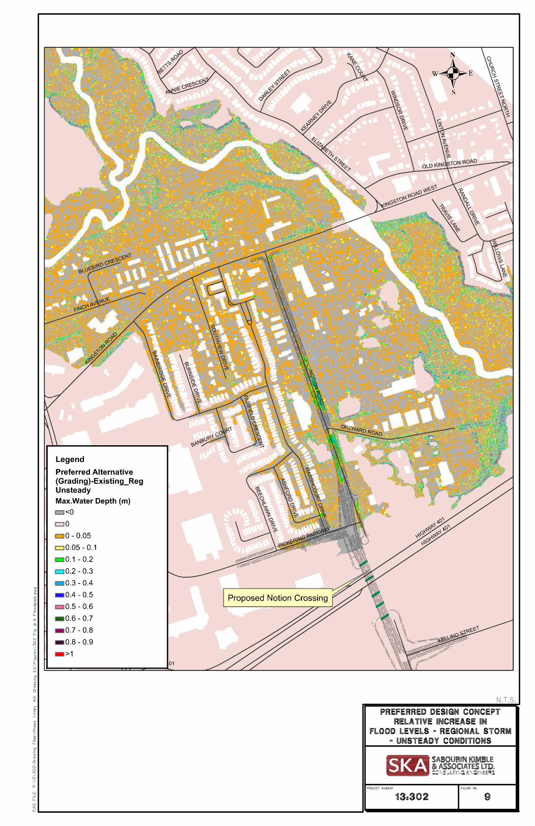
The preferred design concept for the project was developed through the Schedule ‘C’ Municipal Class Environmental Assessment process by co-proponents Pickering Developments Inc. and the City of Pickering. After consultation with potentially affected landowners, the Town of Ajax, Ministry of Transportation and the Toronto and Region Conservation Authority, and consideration of various alternatives, the preferred design concept shown in Figure 2 (back pocket) was selected.
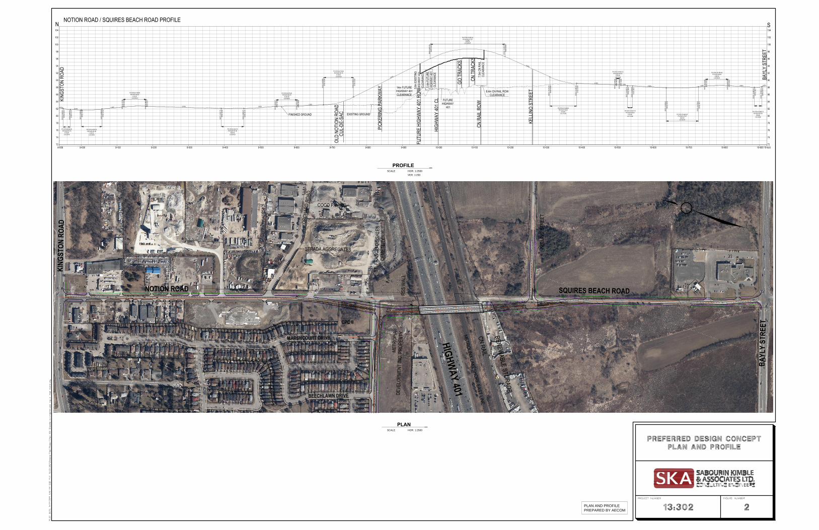
The preferred design concept maintains the ultimate alignment over the current Notion Road right-of-way from Kingston Road in the north to south of Orchard Road where the alignment shifts west to avoid conflict with the existing St. Francis Des Sales cemetery, existing utilities and existing businesses to the east of Notion Road. The proposed road maintains this alignment as it passes over the Highway 401 right-of-way and rail corridor and shifts back to meet the alignment of Squires Beach Road just south of Kellino Street. The existing alignment of Squires Beach Road is maintained until the intersection with Bayly Street at the south limit.
The road profile has been developed in cooperation with the City of Pickering to minimize the elevated portion of the road while still addressing the bridge clearance requirements over Highway 401 and the rail corridor. It is contemplated that the right of way will be 24.0 metres wide with a single northbound and southbound lane plus a centre left turn lane over the Notion Road corridor from Kingston Road to Pickering Parkway. The same road geometry is proposed for the Squires Beach Road corridor from Kellino Street to Bayly Street. The section between Pickering Parkway and Kellino Street will consist of two northbound and southbound lanes separated by a centre median. The section of right-of-way outside of the bridge structure will be 27.0 metres wide with the bridge structure at 25.0 metres wide. Each section of roadway will include a 2.0 metre sidewalk along the western limit and a 4.0 metre wide multi use path along the eastern limit.

HIGHWAY 401
KINGSTON ROAD
CN RAIL
METROLINX LAKESHORE EAST LINEBEECHLAW
N DRIVE
MARSHCOURT DRIVE
PICKERING PARKWAYNOTION ROAD
SQUIRES BEACH ROAD
ORCHARD ROAD
BAYLY STREET
STUDY AREA
3
Storm Drainage Report
4.0 STORM DRAINAGE
4.1 Existing Storm Drainage Characteristics
4.1.1 Squires Beach Road
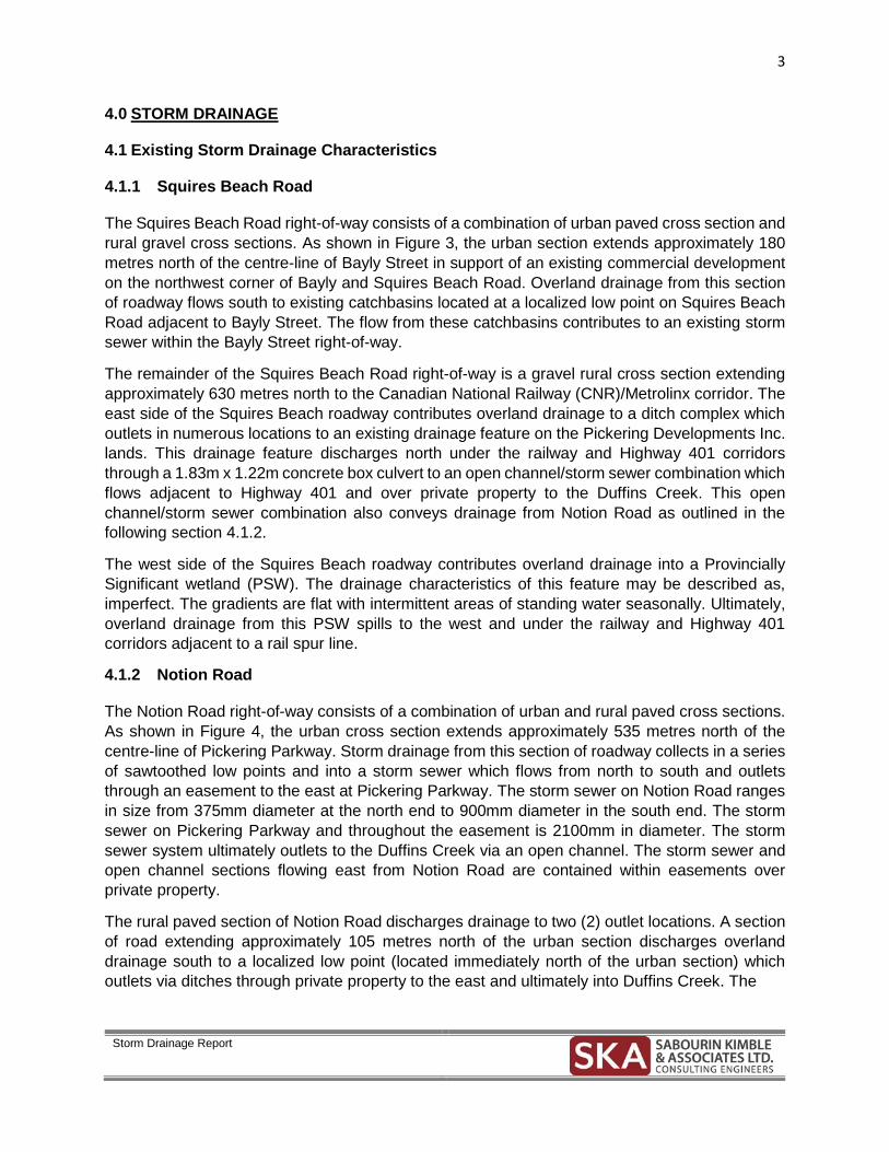
The Squires Beach Road right-of-way consists of a combination of urban paved cross section and rural gravel cross sections. As shown in Figure 3, the urban section extends approximately 180 metres north of the centre-line of Bayly Street in support of an existing commercial development on the northwest corner of Bayly and Squires Beach Road. Overland drainage from this section of roadway flows south to existing catchbasins located at a localized low point on Squires Beach Road adjacent to Bayly Street. The flow from these catchbasins contributes to an existing storm sewer within the Bayly Street right-of-way.
The remainder of the Squires Beach Road right-of-way is a gravel rural cross section extending approximately 630 metres north to the Canadian National Railway (CNR)/Metrolinx corridor. The east side of the Squires Beach roadway contributes overland drainage to a ditch complex which outlets in numerous locations to an existing drainage feature on the Pickering Developments Inc. lands. This drainage feature discharges north under the railway and Highway 401 corridors through a 1.83m x 1.22m concrete box culvert to an open channel/storm sewer combination which flows adjacent to Highway 401 and over private property to the Duffins Creek. This open channel/storm sewer combination also conveys drainage from Notion Road as outlined in the following section 4.1.2.
The west side of the Squires Beach roadway contributes overland drainage into a Provincially Significant wetland (PSW). The drainage characteristics of this feature may be described as, imperfect. The gradients are flat with intermittent areas of standing water seasonally. Ultimately, overland drainage from this PSW spills to the west and under the railway and Highway 401 corridors adjacent to a rail spur line.
4.1.2 Notion Road
The Notion Road right-of-way consists of a combination of urban and rural paved cross sections. As shown in Figure 4, the urban cross section extends approximately 535 metres north of the centre-line of Pickering Parkway. Storm drainage from this section of roadway collects in a series of sawtoothed low points and into a storm sewer which flows from north to south and outlets through an easement to the east at Pickering Parkway. The storm sewer on Notion Road ranges in size from 375mm diameter at the north end to 900mm diameter in the south end. The storm sewer on Pickering Parkway and throughout the easement is 2100mm in diameter. The storm sewer system ultimately outlets to the Duffins Creek via an open channel. The storm sewer and open channel sections flowing east from Notion Road are contained within easements over private property.
The rural paved section of Notion Road discharges drainage to two (2) outlet locations. A section of road extending approximately 105 metres north of the urban section discharges overland drainage south to a localized low point (located immediately north of the urban section) which outlets via ditches through private property to the east and ultimately into Duffins Creek. The

URBAN CROSS SECTIONRURAL GRAVEL
CROSS SECTION
EXISTING PROVINCIALLYSIGNIFICANT WETLAND
ST. FRANCIS
METR
OPIA
DEV
ELOP
MENT
INC.
PRO
PERT
Y
RENEWABLE STORAGE
CN RAIL
METROLINX LAKESHORE EAST LINE
HIGHWAY 401 SQUIRES BEACH ROAD
BAYL
Y ST
REET
LEGEND:
EXISTING STORM SEWERS
EXISTING OVERLANDFLOW DIRECTION
OPEN CHANNEL TODUFFINS CREEK
EXISTINGHEADWALL
EXISTINGCONCRETE STORM
EXISTING CONCRETE STORM
URBAN CROSS SECTIONRURAL PAVEDCROSS SECTION
ST. FRANCISDE SALES
CEMETERY
CPC II
COCO PAVING
CN RAIL
METROLINX LAKESHORE EAST LINE
MARSHCOURT DRIVE
PICK
ERIN
G PA
RKW
AY
STRADA AGGREGATES
ORCH
ARD
ROAD
NOTION ROAD
KING
STON
ROA
D
HIGHWAY 401
DUFFINS CREEK
+ HP + LP
EX 2100Ø STM
EX 375Ø STM
EX 750Ø STM EX 825Ø STM
EX 825Ø STM
EX 900Ø STM
EX 2100Ø STM
LEGEND:
EXISTING STORM SEWERS
EXISTING OVERLANDFLOW DIRECTION
6
Storm Drainage Report
remaining section of Notion Road is approximately 230 metres extending north to Kingston Road. Storm drainage is collected by roadside ditches and captured into the Kingston Road storm sewer.
4.2 Proposed Storm Drainage Works
4.2.1 Squires Beach Road
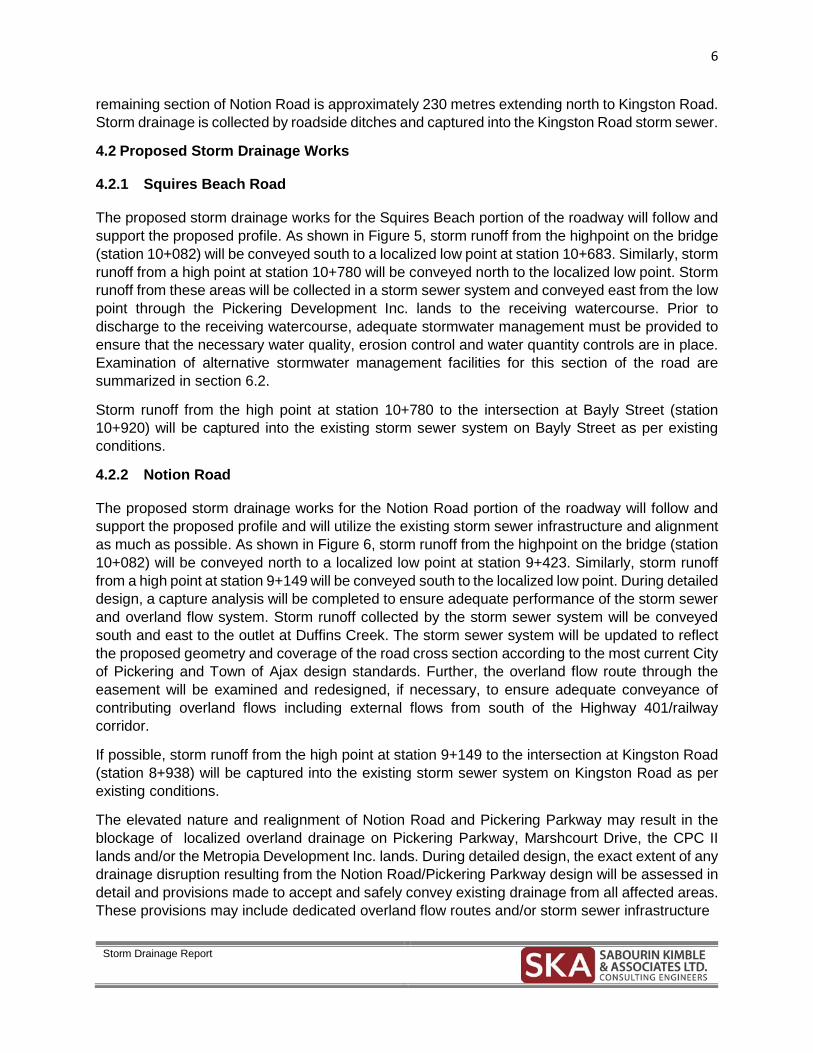
The proposed storm drainage works for the Squires Beach portion of the roadway will follow and support the proposed profile. As shown in Figure 5, storm runoff from the highpoint on the bridge (station 10+082) will be conveyed south to a localized low point at station 10+683. Similarly, storm runoff from a high point at station 10+780 will be conveyed north to the localized low point. Storm runoff from these areas will be collected in a storm sewer system and conveyed east from the low point through the Pickering Development Inc. lands to the receiving watercourse. Prior to discharge to the receiving watercourse, adequate stormwater management must be provided to ensure that the necessary water quality, erosion control and water quantity controls are in place. Examination of alternative stormwater management facilities for this section of the road are summarized in section 6.2.
Storm runoff from the high point at station 10+780 to the intersection at Bayly Street (station 10+920) will be captured into the existing storm sewer system on Bayly Street as per existing conditions.
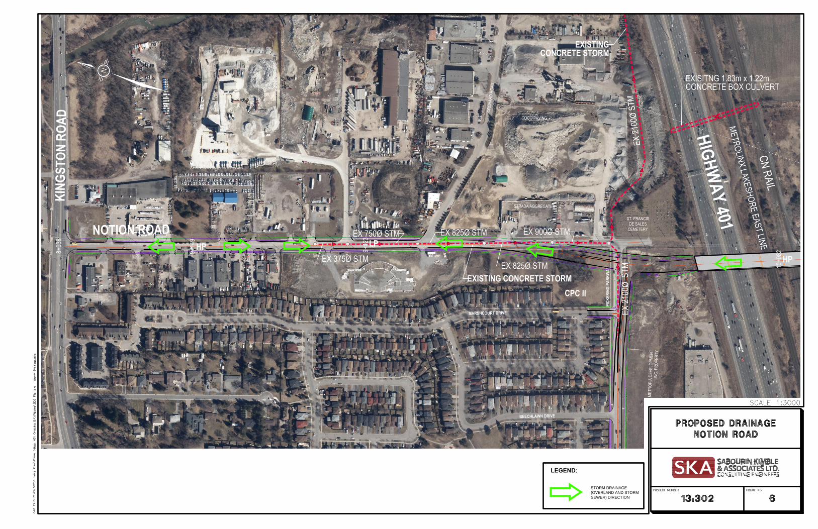
4.2.2 Notion Road
The proposed storm drainage works for the Notion Road portion of the roadway will follow and support the proposed profile and will utilize the existing storm sewer infrastructure and alignment as much as possible. As shown in Figure 6, storm runoff from the highpoint on the bridge (station 10+082) will be conveyed north to a localized low point at station 9+423. Similarly, storm runoff from a high point at station 9+149 will be conveyed south to the localized low point. During detailed design, a capture analysis will be completed to ensure adequate performance of the storm sewer and overland flow system. Storm runoff collected by the storm sewer system will be conveyed south and east to the outlet at Duffins Creek. The storm sewer system will be updated to reflect the proposed geometry and coverage of the road cross section according to the most current City of Pickering and Town of Ajax design standards. Further, the overland flow route through the easement will be examined and redesigned, if necessary, to ensure adequate conveyance of contributing overland flows including external flows from south of the Highway 401/railway corridor.
If possible, storm runoff from the high point at station 9+149 to the intersection at Kingston Road (station 8+938) will be captured into the existing storm sewer system on Kingston Road as per existing conditions.
The elevated nature and realignment of Notion Road and Pickering Parkway may result in the blockage of localized overland drainage on Pickering Parkway, Marshcourt Drive, the CPC II lands and/or the Metropia Development Inc. lands. During detailed design, the exact extent of any drainage disruption resulting from the Notion Road/Pickering Parkway design will be assessed in detail and provisions made to accept and safely convey existing drainage from all affected areas. These provisions may include dedicated overland flow routes and/or storm sewer infrastructure
EXISTING PROVINCIALLYSIGNIFICANT WETLAND
METR
OPIA
DEV
ELOP
MENT
INC.
PRO
PERT
Y
RENEWABLE STORAGE
CN RAIL
METROLINX LAKESHORE EAST LINE
HIGHWAY 401 SQUIRES BEACH ROAD
BAYL
Y ST
REET
HP
10+6
83 LP HP
PROPOSED OUTLET
PICKERINGDEVELOPMENT INC.
10+7
80
10+0
82
10+9
20
POSSIBLE CENTRALIZEDSTORMWATER MANAGEMENT
FACILITY LOCATION
LEGEND:
STORM DRAINAGE(OVERLAND AND STORMSEWER) DIRECTION
EXISTINGCONCRETE STORM
EXISTING CONCRETE STORM
ST. FRANCISDE SALES
CEMETERY
METR
OPIA
DEV
ELOP
MENT
INC.
PRO
PERT
Y
CPC II
COCO PAVING
CN RAIL
METROLINX LAKESHORE EAST LINE
BEECHLAWN DRIVE
MARSHCOURT DRIVE
PICK
ERIN
G PA
RKW
AY
STRADA AGGREGATES
ORCH
ARD
ROAD
NOTION ROAD
KING
STON
ROA
D
HIGHWAY 401
HP
10+0
82
LP
9+42
3
HP9+14
9
EX 2100Ø STM
8+93
8
EX 375Ø STM
EX 750Ø STM EX 825Ø STM
EX 825Ø STM
EX 900Ø STM
EX 2100Ø STM
LEGEND:
STORM DRAINAGE(OVERLAND AND STORMSEWER) DIRECTION
9
Storm Drainage Report
to capture and convey the drainage to an acceptable outlet without causing any flooding on the affected lands.
Options for the required stormwater management works to service this section of the proposed roadway are summarized in section 6.3.
5.0 STORMWATER MANAGEMENT CRITERIA
The entire study area is tributary to the Duffins Creek watershed and is subject to the requirements of the Toronto and Region Conservation Authority (TRCA), City of Pickering, Town of Ajax, Ministry of Transportation and GO/Metrolinx. The following sections provide a brief outline of the applicable stormwater management criteria.
5.1 Water Quality Control
The TRCA requires that all stormwater runoff from new developments must have adequate water quality controls. The treatment system must be designed to satisfy the most current enhanced fisheries protection criteria established in the MOE Stormwater Management Practices Planning and Design Manual (March 2003).Enhanced fisheries protection (Level 1) requires that 80% of total suspended solids (TSS) are to be removed from stormwater effluent.
5.2 Erosion Control
In order to offset downstream erosion potential, the TRCA Stormwater Management Criteria (August 2012) requires that, the runoff from a 25mm storm must be detained and discharged over a period of 48 hours (minimum).
5.3 Water Quantity Control
The development site is within the lower reaches of the Duffins Creek watershed and based on the current TRCA requirements (TRCA Stormwater Management Criteria, August 2012) for this area, no quantity control is required, provided that direct discharge to the receiving watercourse is available. For discharge to the Ministry of Transportation and GO/Metrolinx corridor, peak flows must be maintained at existing levels to ensure existing conveyance characteristics of the transportation corridor drainage works.
5.4 Water Balance
The TRCA and City of Pickering stormwater management criteria require that the first 5mm of runoff from the impervious areas of any proposed development be retained on site. Methods such as infiltration and evapotranspiration can be used to address this water balance target through the provision of Low Impact Development (LID) works. All LID works must be designed in accordance with current MOE Design Manual (March 2003) and TRCA LID design guidelines (2012).
6.0 POSSIBLE STORMWATER MANAGEMENT WORKS
The provision of adequate stormwater management controls for linear developments such as road improvements is often difficult. However, it may be possible to provide the necessary water
10
Storm Drainage Report
balance, water quality control and extended detention in roadside, Low Impact Development (LID) works. These types of facilities may be located within the road right-of-way to provide distributed and at source controls and provide additional amenities to the right-of-way.
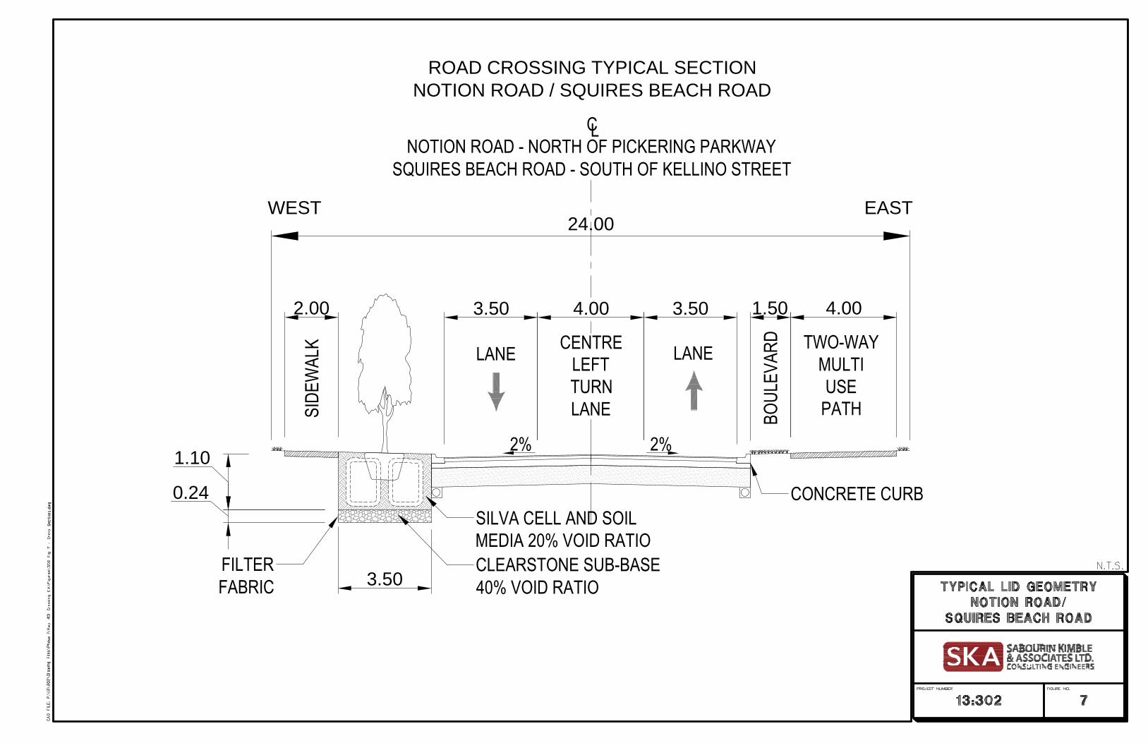
One such system would be a series of subsurface soil cells located within the boulevard which would infiltrate a specified amount of runoff as well as provide bio-retention and extended detention benefits through soil media. The soil media would also house street trees located at a specified separation distance. The street trees would provide addition stormwater management benefits in the form of interception and evapotranspiration. As shown in Figure 7, there is sufficient space between the back of curb and the sidewalk in the west boulevard to install this type of LID system. For reference purposes, design details of the Silva Cell system have been utilized in this evaluation. Silva Cells are modular structural containment units that provide specific volumes for both bio-retention and infiltration purposes.
In this preliminary evaluation, the soil media portion of the silva cells was assumed to provide the bio-retention and extended detention benefits with dimensions of 1.1 metres deep by 3.5 metres wide. Typically, this soil media has a void ratio of 20% resulting in an available unit storage volume of 0.76 m3 of available storage per metre of silva cell.
The silva cells would be placed over a layer of clear stone at a depth of 0.24 metres. This layer would provide for the infiltration component of the installation with a void ratio of 40%. The resultant available unit infiltration storage volume would be 0.34 m3 of available storage per metre of silva cell.
During detailed design, alternative systems may be considered. Based on the Preferred Design Concept, installation of this type of LID would be restricted to the area north of Pickering Parkway on Notion Road and the area south of Kellino Street on Squires Beach Road.
As an alternative to linear LID facilities, and if sufficient land area is available, centralized, end of pipe facilities may also be provided to address all of the stormwater management requirements.
Based on existing conditions, the consideration of any stormwater management works for the roadway north and south of Highway 401 will have to be separate and unique. The following sections provide a brief outline of possible stormwater management works that may be considered in detail as part of the design of each section of roadway.
6.1 Squires Beach Road
The Squires Beach section of roadway does not discharge directly to Duffins Creek. As shown in Figure 5, the drainage from this section of roadway will discharge through the Pickering Development Inc. lands, north under the Ministry of Transportation and GO/Metrolinx corridor to the storm sewer and overland flow route servicing the Notion Road sewer. As such, in addition to the water quality, erosion control and water balance controls, water quantity control must also be provided to control post development flows to pre-development levels at the southern limit of the transportation corridor. For water quality, erosion control and water balance purposes, subsurface
24.00
CNOTION ROAD - NORTH OF PICKERING PARKWAY
SQUIRES BEACH ROAD - SOUTH OF KELLINO STREET
L
ROAD CROSSING TYPICAL SECTIONNOTION ROAD / SQUIRES BEACH ROAD
3.50 3.50
LANE
2%
1.50
2%
BOUL
EVAR
D
4.00
TWO-WAYMULTIUSE
PATH
EASTWEST
LANE
3.50
4.00
CONCRETE CURB
2.00
CENTRELEFTTURNLANESI
DEW
ALK
SILVA CELL AND SOILMEDIA 20% VOID RATIOCLEARSTONE SUB-BASE40% VOID RATIO
FILTERFABRIC
1.10
0.24

12
Storm Drainage Report
soil cells utilized to feed street trees (Silva Cells as shown in Figure 7), were considered in combination with an oil/grit separator. From the high point on the bridge to Bayly Street, the surface area of the right of way is approximately 2.1 hectares with approximately 1.7 hectares of impervious area. The resulting 5 mm infiltration and 25 mm extended detention volumes are 85 m3 and 425 m3, respectively.
From Kellino Street to Bayly Street there is approximately 620 metres of roadway in which the silva cells could be utilized to distribute the storage volumes along the length of the west boulevard. Based on the unit storage volumes available (as identified above) approximately 210 m3 and 470 m3 of infiltration and extended volume is available. Therefore, sufficient road length is available to provide the required storage volumes.
The exact limits, sizing and location of the Silva cells should be evaluated in detail as part of the detailed design exercise for the roadway. The evaluation should include determination of existing ground water elevations, infiltration potential of the receiving soils, detailed grading, specification of the bio-retention media and tree spacing.
The infiltration and bio-retention capabilities of the Silva cells should address the erosion control and water balance requirements for this section of road. Silva cells also provide a high level of total suspended solid (TSS) removal. In order to achieve the enhanced fisheries protection requirements, the Silva cells should be considered in conjunction with an oil/grit separator(s) in a treatment train approach.
In order to control post development flows to pre-development levels, approximately 800 m3 of water quantity storage is required. This storage may be provided within the storm sewer system utilizing oversized pipes, prior to discharge into the receiving watercourse on the Pickering Development Inc. lands.
As an alternative to the stormwater management works outlined above, it may be desirable to combine flows from the Squires Beach right-of-way and a portion of the Pickering Development Inc. lands in a facility located as shown in Figure 5. This facility may provide a portion of, or all of, the stormwater management works required to address the construction of the proposed Squires Beach Road.
During detailed design of the roadway, a detailed evaluation of each stormwater management alternative should be completed to develop an optimized stormwater management scheme which addresses all of the criteria and constraints.
6.2 Notion Road
It is anticipated that the Notion Road section will discharge directly to Duffins Creek and as such, water quantity controls will not be required. Further, land area for any form of centralized facility is not available at this time, therefore, linear treatment train options should be examined.
For evaluation purposes, subsurface soil cells utilized to feed street trees (Silva Cells as shown in Figure 7) were considered in combination with an oil/grit separator. From the high point on the bridge to Kingston Road, the surface area of the right of way is approximately 2.9 hectares with
13
Storm Drainage Report
approximately 2.3 hectares of impervious area. The resulting 5 mm infiltration and 25 mm extended detention volumes are 115 m3 and 575 m3, respectively.
From Pickering Parkway to Kingston Road there is approximately 850 metres of roadway in which the silva cells could be utilized to distribute the storage volumes along the length of the west boulevard. Based on the unit storage volumes available (as identified above) approximately 365 m3 and 645 m3 of infiltration and extended volume is available. Therefore, sufficient road length is available to provide the required storage volumes.
The exact limits, sizing and location of the Silva cells should be evaluated in detail as part of the detailed design exercise for the roadway. The evaluation should include determination of existing ground water elevations, infiltration potential of the receiving soils, detailed grading, specification of the bio-retention media and tree spacing.
The infiltration and bio-retention capabilities of the Silva cells should address the erosion control and water balance requirements for this section of road. Silva cells also provide a high level of total suspended solid (TSS) removal. In order to achieve the enhanced fisheries protection requirements, the Silva cells should be considered in conjunction with an oil/grit separator(s) in a treatment train approach.
7.0 FLOODPLAIN CONSIDERATIONS
The entire study area north of Highway 401 (Notion Road) is flood prone under Regional Storm conditions for Duffins Creek. The flood zone is wide spread and extends beyond the limits of the study area. The flooding potential is created by the flat grades within the area and poor hydraulic characteristics of a downstream railway crossing structure on the Duffins Creek. This situation has been subject to numerous studies and is covered by the provisions of a Special Policy Area (SPA) designation as defined in Section 16.32 of the City of Pickering Official Plan and Section 2.5.5 of the Town of Ajax Official Plan. The potential reconstruction of Notion Road will have to take into consideration the requirements of the Special Policy Area designation and the potential for increased flood risk.
Through discussion and consultation with the Toronto and Region Conservation Authority (TRCA), it was determined that the impact of the construction of the preferred road alternative on the SPA flood levels would have to be assessed utilizing the most recent approved MIKE 11 hydrodynamic model for the Duffins Creek watershed. The MIKE 11 model simulates the watershed response to a specific rainfall event and considers the conveyance and flood storage capacity of the river valley under those rainfall conditions. The TRCA required that the proposed road geometry be assessed under Regional Storm conditions to determine if any detrimental flood increases result from the construction of the road.
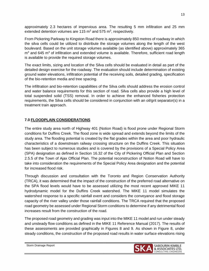
The proposed road geometry and grading was input into the MIKE 11 model and run under steady and unsteady flow conditions as defined in the MIKE 11 Reference Manual (2017). The results of these assessments are provided graphically in Figures 8 and 9. As shown in Figure 8, under steady conditions, the construction of the proposed road results in water surface elevations rising

14
Storm Drainage Report
less than 5 centimetres throughout the SPA area. Increases of between 10 and 20 centimetres may be anticipated in the immediate area of the roadway, however, these increases are restricted to the immediate road area and do not affect any of the existing residences.
Under unsteady conditions (Figure 9), the anticipated results are similar with water surface elevation increases of less than 5 centimetres throughout the SPA area. Similarly, increases of 10 to 20 centimetres are anticipated in the immediate area of the road with no direct impact on any of the existing residences.
Upon review and discussion with the TRCA, these minor increases were deemed acceptable and within the tolerance of the model.


17
Storm Drainage Report
8.0 CONCLUSIONS
Based on the storm drainage and stormwater management assessment completed in support of the Schedule ‘C’ Municipal Class Environmental Assessment for the Highway 401 crossing at Notion Road and Squires Beach Road in the City of Pickering, the following conclusions were reached:
• The existing storm drainage works on Squires Beach Road consist of imperfect rural ditches,
• The existing storm drainage works on Notion Road consist of a combination of urban storm sewers and rural ditches,
• Both roadways discharge runoff to the same outlet at Duffins Creek, • The urbanization of both roadways will require the installation of updated storm sewer
systems, • The urbanization of each roadway will require the consideration of adequate stormwater
management works, • Adequate road length is available to consider the provision of boulevard LID works as part
of the detailed design, • Based on a lack of available land for a centralized stormwater management facility,
stormwater controls for the roadway north of Highway 401 (Notion Road) should be considered within the right-of-way,
• Stormwater management controls for the roadway south of Highway 401 (Squires Beach Road) should be considered within the right-of-way or combined with a centralized facility within the Pickering Development Inc. lands,
• The stormwater management controls for the roadway south of Highway 401 will require the provision of adequate water quantity controls to ensure that post development flows at the GO/Metrolinx corridor are not increased beyond existing levels,
• The exact extent of stormwater management controls should be determined and designed as part of the detailed design of the preferred design concept,
• The road right-of-way north of Highway 401 is contained completely within the Regional Storm floodplain for Duffins Creek and as such is subject to the provisions of a Special Policy Area designation under the Planning Act
• The impact on the Regional Storm flood levels, of proposed grading for the preferred design concept was evaluated with the most current TRCA hydrologic model (MIKE 11),
• The resulting flood level increases were found to be between 10 and 20 centimetres within the immediate area of the roadway with no direct impact on any of the existing residences and 5 centimetres or less within the greater Special Policy Area,
• These minor increases were considered to be acceptable and within the tolerance of the model by TRCA.
PVI STA:8+959.56PVI ELEV:81.81
K:12.00LVC:20.40
BVCS
: 8+9
49.36
BVCE
: 82.0
2
EVCS
: 8+9
69.76
EVCE
: 81.7
8
PVI STA:9+029.20PVI ELEV:81.60
K:45.00LVC:58.50
BVCS
: 8+9
99.95
BVCE
: 81.6
9
EVCS
: 9+0
58.45
EVCE
: 81.9
0
PVI STA:9+423.76PVI ELEV:81.99
K:80.00LVC:64.02
BVCS
: 9+3
91.75
BVCE
: 82.0
8
EVCS
: 9+4
55.77
EVCE
: 82.1
5
PVI STA:9+720.86PVI ELEV:83.18
K:18.00LVC:84.59
BVCS
: 9+6
78.56
BVCE
: 83.0
6
EVCS
: 9+7
63.15
EVCE
: 85.3
0
PVI STA:10+349.99PVI ELEV:89.20
K:18.00LVC:75.58
BVCS
: 10+
312.2
0BV
CE: 9
0.90
EVCS
: 10+
387.7
8EV
CE: 8
9.09
PVI STA:10+537.19PVI ELEV:88.40
K:30.00LVC:14.98
BVCS
: 10+
529.7
0BV
CE: 8
8.48
EVCS
: 10+
544.6
8EV
CE: 8
8.37
PVI STA:10+683.47PVI ELEV:87.67
K:60.00LVC:90.05
BVCS
: 10+
638.4
5BV
CE: 8
7.90
EVCS
: 10+
728.5
0EV
CE: 8
8.12
PVI STA:10+895.73PVI ELEV:87.95
K:8.00LVC:20.80
BVCS
: 10+
885.3
3BV
CE: 8
8.01
EVCS
: 10+
906.1
3EV
CE: 8
8.16
PICK
ERIN
G PA
RKW
AY
HIGH
WAY
401 C
LKING
STON
ROA
D
FUTU
RE H
IGHW
AY 40
1 ROW
CN R
AIL R
OW
KELL
INO
STRE
ET
CN T
RACK
S
GO T
RACK
S
NOTION ROAD / SQUIRES BEACH ROAD PROFILE
EXISTING GROUNDFINISHED GROUND
SN
14m FUTUREHIGHWAY 401CLEARANCE
FUTUREHIGHWAY
401
8.4m CN RAIL ROWCLEARANCE
7.5m
CN R
AIL
CLEA
RANC
E
5.4m
FUTU
REHI
GHW
AY 40
1CL
EARA
NCE
5.8m
EXIS
TING
HIGH
WAY
401
CLEA
RANC
E
OLD
NOTI
ON R
OAD
CUL-
DE-S
AC
BAYL
Y ST
REET
72
74
76
78
80
82
84
86
88
90
92
94
96
98
100
102
104
72
74
76
78
80
82
84
86
88
90
92
94
96
98
100
102
104
+8 938 +9 000 +9 100 +9 200 +9 300 +9 400 +9 500 +9 600 +9 700 +9 800 +9 900 +10 000 +10 100 +10 200 +10 300 +10 400 +10 500 +10 600 +10 700 +10 800 +10 900 +10 920
-0.30%
1.00% -0.60% 2.00%
0.50%0.30%
5.00%
-4.50%
-2.00%
-0.30% -1.00%-0.50%
-0.30%1.00%
PVI STA:10+780.58PVI ELEV:88.64
K:40.00LVC:64.00
BVCS
: 10+
748.5
8BV
CE: 8
8.32
EVCS
: 10+
812.5
8EV
CE: 8
8.45
PVI STA:9+575.80PVI ELEV:82.75
K:300.00LVC:60.05
BVCS
: 9+5
45.77
BVCE
: 82.6
0
EVCS
: 9+6
05.82
EVCE
: 82.8
4
PVI STA:10+082.22PVI ELEV:101.25
K:22.00LVC:208.97
BVCS
: 9+9
77.73
BVCE
: 96.0
3
EVCS
: 10+
186.7
0EV
CE: 9
6.55
PVI STA:9+149.88PVI ELEV:82.81
K:50.00LVC:65.00
BVCS
: 9+1
17.38
BVCE
: 82.4
9
EVCS
: 9+1
82.38
EVCE
: 82.7
1
PVI STA:10+503.12PVI ELEV:88.74
K:18.00LVC:12.60
BVCS
: 10+
496.8
2BV
CE: 8
8.76
EVCS
: 10+
509.4
2EV
CE: 8
8.68
ST. F
RANC
IS D
E SA
LES
CEME
TERY
METR
OPIA
DEVE
LOPM
ENT
INC.
PRO
PERT
Y
CPC II
COCO PAVING
RSS
WAL
L
CN RAIL
METROLINX LAKESHORE EAST LINE
BEECHLAWN DRIVE
MARSHCOURT DRIVE
PICK
ERIN
G PA
RKW
AY
STRADA AGGREGATES
ORCH
ARD
ROAD
8+938
9+000
9+100
9+200
9+300
9+400
9+500
9+600 9+700
9+800 9+900
10+000
10+100
10+200
10+300
10+400
10+500
10+600
10+700
10+800
10+900
10+920
PI: 9+012.72
PI: 9+174.41
PI: 9+341.14
BC: 9+551.38
EC: 9+729.09
TS: 9+794.13
SC: 9+825.38
CS: 9+902.28
ST: 9+933.53
BC: 10+153.35
EC: 10+232.42
BC: 10+353.42
EC: 10+537.67
PI: 10+620.05
PI: 10+729.79
PI: 10+759.77
PI: 10+788.09
PI: 10+805.76
PI: 10+865.25
10+200
10+300
10+400
10+428
BC: 10+189.13
EC: 10+343.85
10+000
10+100
10+200
10+300
10+315
9+988
10+000
10+100
10+143
BC: 10+001.82
EC: 10+025.95
BC: 10+054.83
EC: 10+081.18
PI: 10+106.39
PI: 10+138.17
0+000
0+082
PI: 0+060.00
NOTION ROAD
KING
STON
ROA
D
HIGHWAY 401
SQUIRES BEACH ROAD
BAYL
Y ST
REET
PROFILE _SCALE HOR. 1:2500
VER. 1:250
PLAN _SCALE HOR. 1:2500
PLAN AND PROFILEPREPARED BY AECOM