stormwater management master plan - city of guelph · guelph stormwater management master plan city...
TRANSCRIPT

STORMWATER MANAGEMENT MASTER PLAN
AMEC Environment & Infrastructure in association with:
BLACKPORT AND ASSOCIATES C. PORTT AND ASSOCIATES DOUGAN AND ASSOCIATES
PARISH GEOMORPHIC
February 13, 2012
STORMWATER MANAGEMENT MASTER PLAN
CITY OF GUELPH
Final
Submitted to: City of Guelph Guelph, Ontario
Submitted by: AMEC Environment & Infrastructure
3215 North Service Road, Box 220 Burlington, ON L7N 3G2
Tel: 905-335-2353 Fax: 905-335-1414
February 13, 2012
Guelph Stormwater Management Master Plan City of Guelph February 13, 2012 – Final
TABLE OF CONTENTS
Project Number: 108181 i
Executive Summary .................................................................................................... ES-1 1. INTRODUCTION ............................................................................................................... 1
1.1 Study Purpose Objectives ..................................................................................... 2 1.2 Master Plan Process ............................................................................................. 2 1.3 Public/Agency Consultation ................................................................................... 4 1.4 Schedule ............................................................................................................... 5 1.5 Project Organization .............................................................................................. 6 1.6 Reporting Overview ............................................................................................... 7 1.7 Stakeholder and Agency Consultation .................................................................. 8
1.7.1 Phase 1 Consultation................................................................................. 8 1.7.2 Phase 2 Consultation............................................................................... 10 1.7.3 Public Review of Stormwater Management Master Plan ......................... 11
2. BACKGROUND INFORMATION AND STUDY AREA PROFILE ................................... 13
2.1 Land Use and City’s Strategic Growth Plan ........................................................ 14 2.2 Aquatic Habitat .................................................................................................... 14 2.3 Terrestrial Habitat ................................................................................................ 14 2.4 Hydrogeology ...................................................................................................... 18 2.5 Surface Water Quality ......................................................................................... 20 2.6 Groundwater Quality ........................................................................................... 22 2.7 Streamflow/Creek Systems ................................................................................. 22 2.8 Climate Data ........................................................................................................ 25 2.9 Infrastructure ....................................................................................................... 26
3. AREAS OF CONCERN ................................................................................................... 28
3.1 Sediment Quality ................................................................................................. 28 3.2 River/Creek Bank Erosion ................................................................................... 28 3.3 Flooding ............................................................................................................... 30 3.4 Groundwater Levels/Well Head Protection Areas ............................................... 31
4. FIELD INVESTIGATIONS ............................................................................................... 33
4.1 Stormwater Management Infrastructure .............................................................. 33 4.2 Natural Environment ............................................................................................ 34
4.2.1 Stream Reaches ...................................................................................... 34 4.2.2 Terrestrial Habitat .................................................................................... 40
4.3 Field Monitoring of Rainfall and Runoff ............................................................... 44 5. DRAINAGE SYSTEM PERFORMANCE ASSESSMENT ............................................... 47
5.1 Standards ............................................................................................................ 47 5.1.1 Historical Application of Stormwater Management Techniques .............. 47 5.1.2 Rainfall and Climate Trend Analysis ........................................................ 47 5.1.3 Infrastructure............................................................................................ 50
5.2 Major/Minor System Modelling ............................................................................ 51 5.2.1 Model ....................................................................................................... 51 5.2.2 Data ......................................................................................................... 52 5.2.3 Analysis Approach ................................................................................... 54 5.2.4 Model Calibration ..................................................................................... 57 5.2.5 Minor System Assessment ...................................................................... 60 5.2.6 Major System Assessment ...................................................................... 62 5.2.7 Assessment of Alternatives ..................................................................... 64

Guelph Stormwater Management Master Plan City of Guelph February 13, 2012 – Final
TABLE OF CONTENTS
Project Number: 108181 ii
5.2.8 Continuous Modelling Verification ........................................................... 74 5.2.9 Climate Change Sensitivity Analysis ....................................................... 78
5.3 Prioritization of Proposed Drainage System Upgrades ....................................... 80 5.3.1 Prioritization Evaluation Criteria ............................................................... 80 5.3.2 Drainage Network Prioritization (Risk) ..................................................... 81 5.3.3 Drainage System Upgrade Projects Prioritization .................................... 82
5.4 Infill and Intensification Flood Storage Assessment ............................................ 86 5.5 Low Impact Development .................................................................................... 90
6. STORMWATER QUALITY MANAGEMENT ASSESSMENT .......................................... 94
6.1 Process ............................................................................................................... 94 6.2 Growth Management Strategy............................................................................. 94 6.3 Stormwater Quality Management Approaches .................................................... 95 6.4 Nutrient Offset Program Feasibility .................................................................... 102 6.5 Total Mass Loading Monitoring Program ........................................................... 104
7. IMPLEMENTATION ...................................................................................................... 107
7.1 Summary of Recommendations ........................................................................ 107 7.1.1 Minor System ......................................................................................... 107 7.1.2 Major System ......................................................................................... 108 7.1.3 Stormwater Quantity Management ........................................................ 108 7.1.4 Stormwater Quality Management .......................................................... 110
7.2 Process ............................................................................................................. 110 7.2.1 Class Environmental Assessments ....................................................... 110 7.2.2 Development Led Projects ..................................................................... 111
7.3 Operations and Maintenance ............................................................................ 111 7.4 City Stormwater Monitoring Protocols ............................................................... 112 7.5 Funding Sources for Stormwater Management Projects ................................... 115 7.6 Stormwater Management Design Standards and Policy Review ...................... 117 7.7 City Staff Use of PCSWMM Hydrologic/ Hydraulic Modelling ........................... 119
APPENDICES
Appendix ‘A’ Public Record Appendix ‘B’ Bibliography Appendix ‘C’ Field Reconnaissance Appendix ‘D’ GRCA 2008-2009 Surface Water Quality Monitoring Program Appendix ‘E’ Climate Data and Trend Analysis Appendix ‘F’ City of Guelph Stormwater Management Facility Inventory Appendix ‘G’ Hydrogeology Appendix ‘H’ Significant Plant List Appendix ‘I’ Monitoring and Calibration Data Appendix ‘J’ Subcatchment Boundary Plans and PCSWMM Modeling Files Appendix ‘K’ Drainage Network Deficiencies and Recommended Plans Appendix ‘L’ Preliminary Designs for Stormwater Quality Retrofit and Prioritized
Quantity Control Facilities Appendix ‘M’ Drainage System Upgrades Costing Estimates Appendix ‘N’ Water Quality Simulation Modelling Options Appendix ‘O’ Drainage Network Summary Sheets Appendix ‘P’ Low Impact Development (LID) Best Management Practices (BMPs)

Guelph Stormwater Management Master Plan City of Guelph February 13, 2012 – Final
TABLE OF CONTENTS
Project Number: 108181 iii
DRAWINGS
Drawing 1 Study Area Drawing 2 Aerial Photography (2006) Drawing 3 Subwatershed Boundaries Drawing 4 Existing Land Use Drawing 5 2001 Official Plan Land Use Drawing 6 Stormwater Management Infrastructure and Drainage Area Plan Drawing 7 Areas of Concern Drawing 8 Storm Sewers on Private Property Drawing 9 Flood Control Areas and SWM Facility Location Plan Drawing 10 Water Quality Treatment Areas & SWM Facility Location Plan Drawing 11 Drainage Network Boundary Plan Drawing 12 Minor Systems Deficiencies Plan (5 year Storm) Drawing 13 Major Systems Deficiencies Plan (100 year Storm) Drawing 14 Recommended Drainage System Upgrades Plan Drawing 15 High Priority Neighbourhood Scale LID Application Areas Drawing 16 Network based Drainage System Upgrade Prioritization Plan Drawing 17 SWM Quality Management Retrofit Areas Location Plan
APPENDIX ‘I’ DRAWINGS
Drawing I1 Monitoring Program Site Locations
APPENDIX ‘J’ DRAWINGS
Drawing J1 Subcatchment boundary plan for Networks CC01, CC02, HD05, and HD06 Drawing J2 Subcatchment boundary plan for Networks HD03 and HD04 Drawing J3 Subcatchment boundary plan for Network HD02 Drawing J4 Subcatchment boundary plan for Network US06 Drawing J5 Subcatchment boundary plan for Network US01 Drawing J6 Subcatchment boundary plan for Network ER01 Drawing J7 Subcatchment boundary plan for Network US02 Drawing J8 Subcatchment boundary plan for Network US04 Drawing J9 Subcatchment boundary plan for Networks US03 and HD01 Drawing J10 Subcatchment boundary plan for Network US09 Drawing J11 Subcatchment boundary plan for Network US05 Drawing J12 Subcatchment boundary plan for Network US07 Drawing J13 Subcatchment boundary plan for Network US10 Drawing J14 Subcatchment boundary plan for Network US11 Drawing J15 Subcatchment boundary plan for Network US08 Drawing J16 Subcatchment boundary plan for Network LS02 Drawing J17 Subcatchment boundary plan for Network LS03 Drawing J18 Subcatchment boundary plan for Networks LS14 and LS15 Drawing J19 Subcatchment boundary plan for Network LS04 Drawing J20 Subcatchment boundary plan for Networks NW01, NW02, and NW04 Drawing J21 Subcatchment boundary plan for Network WW06 Drawing J22 Subcatchment boundary plan for Network WW05 Drawing J23 Subcatchment boundary plan for Networks WW01 and WW04 Drawing J24 Subcatchment boundary plan for Networks WW02 and WW03

Guelph Stormwater Management Master Plan City of Guelph February 13, 2012 – Final
TABLE OF CONTENTS
Project Number: 108181 iv
Drawing J25 Subcatchment boundary plan for Network LS06 Drawing J26 Subcatchment boundary plan for Networks NW03, WW07, and WW08 Drawing J27 Subcatchment boundary plan for Networks LS01, LS07, and LS16 Drawing J28 Subcatchment boundary plan for Networks LS08, LS09, LS10, and LS17 Drawing J29 Subcatchment boundary plan for Networks LS05 and LS11 Drawing J30 Subcatchment boundary plan for Networks HC08, HC09, HC10,
LS12, and LS13 Drawing J31 Subcatchment boundary plan for Networks HC01, HC02, and HC03 Drawing J32 Subcatchment boundary plan for Networks HC04, HC05, HC06, and HC07
APPENDIX ‘K’ DRAWINGS
Drawing K1 Ward 1 Area – Minor System under 5 Year Design Storm Drawing K2 Ward 2 Area – Minor System under 5 Year Design Storm Drawing K3 Ward 3 Area – Minor System under 5 Year Design Storm Drawing K4 Ward 4 Area – Minor System under 5 Year Design Storm Drawing K5 Ward 5 & 6 Area – Minor System under 5 Year Design Storm Drawing K6 Ward 1 Area – Major System under 100 Year Design Storm Drawing K7 Ward 2 Area – Major System under 100 Year Design Storm Drawing K8 Ward 3 Area – Major System under 100 Year Design Storm Drawing K9 Ward 4 Area – Major System under 100 Year Design Storm Drawing K10 Ward 5 & 6 Area – Major System under 100 Year Design Storm Drawing K11 Ward 1 Area – Recommended Upgrades to meet 5 Year Capacity Drawing K12 Ward 2 Area – Recommended Upgrades to meet 5 Year Capacity Drawing K13 Ward 3 Area – Recommended Upgrades to meet 5 Year Capacity Drawing K14 Ward 4 Area – Recommended Upgrades to meet 5 Year Capacity Drawing K15 Ward 5 & 6 Area – Recommended Upgrades to meet 5 Year Capacity
APPENDIX ‘L’ DRAWINGS
Drawing L1 Preliminary Concept Design of Retrofit Pond 1 Drawing L2 Preliminary Concept Design of Retrofit Pond 2 Drawing L3 Preliminary Concept Design of Retrofit Pond 3 Drawing L4 Preliminary Concept Design of Retrofit Pond 4 Drawing L5 Preliminary Concept Design of Retrofit Pond 4a Drawing L6 Preliminary Concept Design of Retrofit Pond 5 Drawing L7 Preliminary Concept Design of Retrofit Pond 6 Drawing L8 Preliminary Concept Design of Retrofit Pond 7 Drawing L9 Preliminary Concept Design of Retrofit Pond 8 Drawing L10 Preliminary Concept Design of Retrofit Pond 9 Drawing L11 Preliminary Concept Design of Retrofit Pond 10 Drawing L12 Preliminary Concept Design of Green Meadows Facility Drawing L13 Preliminary Concept Design of Waverly Drive Facility

Guelph Stormwater Management Master Plan City of Guelph February 13, 2012 – Final
TABLE OF CONTENTS
Project Number: 108181 v
FIGURES
Figure 1.1 Municipal Class EA Process Figure 2.1 Locations of existing data found through the background review, with
the names of the associated watersheds Figure 2.2 Streams identified as sensitive based on the background review Figure 2.3 Reaches delineated within the study area Figure 3.1 Location of reaches that migrated over the study period Figure 3.2 Stream power estimates for the study area Figure 4.1 Locations of reaches identified for conducting field work
APPENDIX ‘I’ FIGURES
Figure I1 Rating Curve for Willow West Monitoring Site (WW06) Figure I2 Rating Curve for Stone Road Monitoring Site (LS05) Figure I3 Rating Curve for Railway (D/S) Monitoring Site (LS02) Figure I4 Rating Curve for Waverly Monitoring Site (US03) Figure I5 Rating Curve for Northwest Channel Monitoring Site (NW04) Figure I6 Rating Curve for Schroder Monitoring Site (HD02) Figure I7 Rating Curve for Woodlawn Monitoring Site (US10) Figure I8 Willow West Site (Network WW06) Monitoring Data Figure I9 Stone Road Site (Network LS05) Monitoring Data Figure I10 Railway (U/S Side) Site (Network LS02) Monitoring Data Figure I11 Railway (D/S Side) Site (Network LS02) Monitoring Data Figure I12 Waverly Drive Site (Network US03) Monitoring Data Figure I13 North-West Channel Site (Network NW04) Monitoring Data Figure II14 Schroder Site (Network HD02) Monitoring Data Figure I15 Woodlawn Site (Network US10) Monitoring Data Figure I16 Ward 1 Site (Network HD02) Monitoring Data Figure I17 Calibration Scatter Plot: Residential Land Use Sewershed Models
(HD02, LS02, LS05, US03) Figure I18 Calibration Scatter Plot: Industrial Land Use Sewershed Models
(NW04, US10, WW06) Figure I19 Calibration Scatter Plot: All gauged Sewershed Models (HD02, LS02,
LS05, NW04, US03, US10, WW06)
Guelph Stormwater Management Master Plan City of Guelph February 13, 2012 – Final
TABLE OF CONTENTS
Project Number: 108181 vi
TABLES
Table 3.1 Average Migration Rates within the Study Area Table 4.1 Reach Descriptions and Rapid Assessment Scores Table 4.2 Significant Observed Rainfall Events between June 25 and
December 3, 2010 Table 5.1 Summary of Current Intensity-Duration Frequency Parameters for the
City of Guelph Table 5.2 Summary of Current Rainfall Frequency Depths for the City of Guelph Table 5.3 Comparison of Currently Applied Frequency Depths (1954-1970) to
Updated Frequency Depths (1954-2010) for the City of Guelph Table 5.4 Comparison of Frequency Depths for Different Historic Periods for the
City of Guelph Table 5.5 Summary of Modifications to Assumed Imperviousness for Different
Land Use Segments based on Calibration Table 5.6 Summary of Simulated Minor System Performance for all Drainage
Networks (City-Wide) Table 5.7 Summary of Simulated Major System Performance for all Drainage
Networks (City-Wide) Table 5.8 Summary of Preliminary Recommended Upgrades to meet 5 year
Capacity for all Drainage Networks (City-Wide) Table 5.9 Summary of Preliminary Recommended Upgrades to meet 5 year
Capacity for City Areas and City-Wide Table 5.10 Summary of Continuous Simulation Modelling Verification (2001-
2010) of Recommended Drainage System Upgrades Table 5.11 Rainfall Characteristics of Major Storm Events for Continuous
Simulation Verification Table 5.12 Comparison of Frequency Flows between Continuous Simulation and
Design Storm Methodologies Table 5.13 Results of Climate Change Sensitivity Analysis on Drainage Network
Upgrades for Selected Networks Table 5.14 Estimated Additional Cost to Upgrade Drainage Network to Climate
Change Estimated 5 year Capacity (Current 10 year Storm Event) Table 5.15 Network Prioritization Criteria for Drainage System Upgrades Table 5.16 Network Prioritization Scoring for Drainage System Upgrades Table 5.17 Sewershed Network Prioritization for Upgrades (City-Wide) Table 5.18 Top 25 Prioritized Drainage System Upgrades (Quantity Control) Table 5.19 Infill and Intensification Flood Storage Requirements by Sewershed Table 5.20 Infill and Intensification Unitary Storage Requirements by Sewershed Table 5.21 LID Source and Conveyance Controls Table 5.22 High Priority LID/BMP Neighbourhoods Table 6.1 Preliminary Stormwater Quality Retrofit Opportunities Table 7.1 Proposed Stormwater Quantity Control Facility Summary
Guelph Stormwater Management Master Plan City of Guelph February 13, 2012 – Final
TABLE OF CONTENTS
Project Number: 108181 vii
APPENDIX ‘J’ TABLES
Table J1 Hydrologic Modelling Parameters Table J2 Percentage Imperviousness Calculations
APPENDIX ‘K’ TABLES Table K1 Drainage System Upgrade Summary Notes
APPENDIX ‘L’ TABLES Table L1 Preliminary Cost Estimate – Retrofit Pond No. 1 Table L2 Preliminary Cost Estimate – Retrofit Pond No. 2 Table L3 Preliminary Cost Estimate – Retrofit Pond No. 3 Table L4 Preliminary Cost Estimate – Retrofit Pond No. 4 Table L5 Preliminary Cost Estimate – Retrofit Pond No. 5 Table L6 Preliminary Cost Estimate – Retrofit Pond No. 6 Table L7 Preliminary Cost Estimate – Retrofit Pond No. 7 Table L8 Preliminary Cost Estimate – Retrofit Pond No. 8 Table L9 Preliminary Cost Estimate – Retrofit Pond No. 9 Table L10 Preliminary Cost Estimate – Retrofit Pond No. 10 Table L11 Preliminary Cost Estimate – Green Meadows Park SWM Facility Table L12 Preliminary Cost Estimate – Waverly Drive SWM Facility
APPENDIX ‘M’ TABLES Table M1 Detailed Cost Estimates for Recommended Storm Sewer Upgrades to
meet 5 year Capacity Table M2 Estimated Costs for Downspout Disconnection for Identified
Sewershed Networks Table M3 Detailed Cost Estimates for Recommended Storm Sewer Upgrades to
meet a 10 year Capacity (Climate Change Sensitivity Analysis) Table M4 Detailed Cost Estimates for “Top 25” Priority Projects

Guelph Stormwater Management Master Plan City of Guelph February 13, 2012 – Final
Project Number: 108181 ES-1
EXECUTIVE SUMMARY Introduction The City of Guelph and the surrounding Wellington County is anticipated to grow by 125,000 people based on Provincial population targets to 2031. The City has a current population of 115,000 (as of 2006), and has been experiencing considerable growth during the last decade. Major new residential and employment areas have been, and continue to be, developed in suburban areas of the City. The City Council has endorsed a plan to support a 2031 population of 169,000 and an additional 31,000 jobs over a 25 year planning horizon (ref. 2008 City of Guelph Growth Management Strategy). While the primary future growth will continue to be within Greenfield areas (i.e. outside the existing built-up area of the City), it is projected that by 2015 the overall share of infill and intensification residential growth will gradually increase to 40 percent of new residential development, generally in-line with provincial targets (ref. 2008 City of Guelph Growth Management Strategy). The infill and intensification projects within the City’s existing urban built boundary will add additional strain to the City’s infrastructure, in particular, the storm drainage systems. Goal The main goal of the Stormwater Management (SWM) Master Plan is to develop a long-term plan for the safe and effective management of stormwater runoff from urban areas while improving the ecosystem health and ecological sustainability of the Eramosa and Speed Rivers and their tributaries. The SWM Master Plan integrates aspects of flood control, groundwater and surface water quality, natural environment and system drainage issues into a cohesive City-wide strategy. Objectives The objectives of the SWM Master Plan include the following: Water Quality
– Improve sediment, surface water and groundwater quality. – Minimize pollutant loadings to groundwater and surface water. – Improved aesthetics of creeks and rivers through the elimination of garbage/litter,
algae growth, turbidity, and odours.
Water Quantity – Preserve and re-establish the natural hydrologic process to protect, restore and
replenish surface water and groundwater resources. – Reduce the impacts of erosion on aquatic and terrestrial habitats and property. – Minimize the threats to life and property from flooding.
Natural Environment – Protect, enhance and restore natural features and functions such as wetlands,
riparian and ecological corridors. – Improve warmwater and coldwater fisheries if appropriate.

Guelph Stormwater Management Master Plan City of Guelph February 13, 2012 – Final
Project Number: 108181 ES-2
Project Process The City of Guelph Stormwater Management Master Plan has been prepared in accordance with the Municipal Engineers Association (MEA) Class Environmental Assessment (Class EA) procedures. The Master Plan has adopted Approaches #1 and #2 from the 2007 MEA Class EA Document. Approach # 1 involves the creation of a Master Plan document which fulfills Phases 1 and 2 of the Municipal Class EA process. All Schedule ‘B’ projects within this approach which are implemented in accordance with the recommendations provided in this Master Plan require filing of a Project File for public review before the detailed design and implementation stages of a Schedule ‘B’ or ‘C' project can be fulfilled. Under Approach # 2, the Master Plan fulfills the Municipal Class EA requirements for all Schedule ‘B’ projects expected to be implemented in the 0 to 5 year timeframe. For all such Schedule ‘B’ projects, the final public notice for the Master Plan becomes the Notice of Completion for the recommended stormwater management facility projects. The SWM Master Plan has been managed by a City Project Manager and a Committee comprised of several Municipal Departments. This Committee provided guidance on Project priorities, local issues/needs, and general overall direction with respect to the project deliverables. In addition, the Project has received insight from a Technical Advisory Committee comprised of representatives from the Grand River Conservation Authority, University of Guelph, as well as practitioners in the field including engineering consultants and developers The Project Team was led by AMEC Earth & Environmental with specialty support from Dougan and Associates (Natural Heritage), C. Portt and Associates (Fisheries), Blackport and Associates (Groundwater), and Parish Geomorphic (Stream Morphology). The project followed a task-based work plan with the following primary tasks: Task 1: Study Area Profile Task 2: Define Goals and Objectives Task 3: Storm Sewer System and Water Quality Models Task 4: Alternatives Evaluation Task 5: Preferred Stormwater Management Strategy Task 6: Public Consultation Task 7: Implementation Plan Task 8: Stormwater Management Master Plan Report Study Area Profile and Areas of Concern The Project Team conducted an assessment of the Study Area in an effort to better understand the environmental features potentially influencing the selection and implementation of various management solutions, as well as the problems and areas of concern which underpin the purpose of the Master Plan. The following provides a brief overview of Study Area Profile and Areas of Concern:
Guelph Stormwater Management Master Plan City of Guelph February 13, 2012 – Final
Project Number: 108181 ES-3
Profile Aquatic Habitat All of the major watercourses within the City have been classified by the MNR/GRCA with respect to fish communities (warmwater, coldwater or coolwater), however a local number of the smaller watercourses that have not been the subject of a subwatershed study have not. Hanlon and Clythe Creek are considered coldwater streams. Hadati Creek is considered a coolwater stream and the remainder of the watercourses are either warmwater streams or are unclassified. It is expected that most of the unclassified watercourses will provide warmwater habitat, however reconnaissance level fish sampling (electrofishing) would be required to be certain of their status. Vegetation Communities Within the City of Guelph, the percentage natural cover (defined as all natural and cultural cover, excluding lands being used for agriculture and other managed open spaces) is currently calculated to be just under 25%, of which less than half are considered to be fragments of original natural areas. A large portion of these remnants are wetland areas (i.e. swamps and marshes, as well as open water). Currently, the City’s forested cover (including cultural woodlands, plantations and swamps, which are forested wetlands) encompasses about 1100 ha (12%). When adjacent forested cover is combined, some of these forested areas are quite large (>60ha). These forested complexes provide interior forest habitat (100+ m away from any forest edge) that is rarely found in within the urban boundaries of most southern Ontario municipalities. Wildlife The City of Guelph NHS has a Significant Wildlife List which includes 286 species of conservation concern. None of the wildlife species observed during the field work for the NHS are considered nationally or provincially rare, but a limited number of rare species have been noted as part of previous studies in the City. Natural Heritage as related to Stormwater Management Facilities There is a range of issues and potential conflicts that the planning, construction, operation and maintenance of SWM facilities may pose to the nearby natural environments. These issues include directs effects of construction, and indirect effects on local hydrology, water quality and hydroperiods which may affect existing habitats in the receiving system. Other indirect effects relate to the quality of habitats that are either intentionally created in facilities, or which evolve through natural succession irrespective of the original design intentions. As facilities become integrated as habitat, their intended periodic management may become problematic, if (for example) Species at Risk begin to utilize them, or habitats with other significant qualities and functions become established.

Guelph Stormwater Management Master Plan City of Guelph February 13, 2012 – Final
Project Number: 108181 ES-4
Hydrogeology (Groundwater) Water from precipitation percolates or infiltrates into the ground until it reaches the water table. Areas where water moves downward from the water table are known as recharge areas. These areas are generally in areas of topographically high relief. Areas where groundwater moves upward to the water table are known as discharge areas. These generally occur in areas of topographically low relief, such as stream valleys. Groundwater that discharges to streams is the water that maintains the baseflow of the stream. Wetlands may be fed by groundwater discharge. Throughout the City significant recharge will occur in areas where there are more permeable sediments and the within the elevated, depressional topography of the Paris Moraine. This water may move through the shallow flow system to more local reaches of water courses or in some cases to local wetlands. This shallow flow is more predominant where the overburden unit overlying the bedrock is a less permeable till. Where the permeable overburden is connected to the shallow bedrock recharge will move into bedrock flow system. The amount of water moving to the deeper bedrock and the municipal well production unit of the middle portion of the Amabel Formation depends, in part, on the thickness and characteristics of the Eramosa Member and the upper portion of the Amabel Formation. A detailed hydrogeological study is currently being conducted by the City of Guelph and is expected to be released during 2012. This Tier 3 Source Protection Study will provide the most up to date characterization. As part of the Tier 3 Source Protection Study, the steering committee will develop a Discussion Paper describing the determined threats to source water. One of these threats will include stormwater management; hence there will be a need to develop a tool kit for addressing potential impacts on water quality from stormwater management. The Discussion Paper would ultimately inform the Source Protection Committee and the public on potential threats and opportunities from stormwater management. The City of Guelph will then follow-up with the best approaches to addressing its issues within its current setting. Surface Water Quality A 'desktop' assessment of available data has been conducted to determine the relative conditions of Guelph's open waterways. Surface water quality data and background characterization information has been reviewed for the Hanlon Creek, Torrance Creek, Eramosa River and Clythe Creek. In general terms, each of the watershed systems (based on water chemistry sampling) has some level of degradation associated with urban and/or rural land use impacts. Sampling efforts continue by GRCA for the Speed River, Eramosa River, and Hanlon Creek. Groundwater Quality Groundwater quality in both the overburden and the bedrock is of the calcium-magnesium-bicarbonate type water and is generally high in total dissolved solids (TDS). Higher total dissolved solids are found in the deeper bedrock systems where the residence time of the

Guelph Stormwater Management Master Plan City of Guelph February 13, 2012 – Final
Project Number: 108181 ES-5
groundwater has been longer. Elevated levels of sodium and chloride are found in a number of wells which may be indicative of road salt. Iron is relatively high within the bedrock due to its composition. Streamflow/Creek Systems The study of streams primarily focused on a desktop analysis of existing geomorphic conditions within the City of Guelph. This work optimized the existing available information already available for each subwatershed within the City, including existing subwatershed, stormwater management and drainage studies, geographic information and aerial photography. Building on the work presented within the numerous background reports, reaches were confirmed, refined or delineated for each of the major watercourses in the study area. The background review revealed several reaches that were classified as being sensitive to disturbances during previous assessments. The majority of the sites previously studied were identified as being sensitive. However, a review of this was deemed necessary, as many of the studies were conducted over a decade ago. Also, new protocols have been developed for use in determining stability from a geomorphic perspective. Areas of Concern Sediment Quality Although an extensive review of background information has been conducted, no information has been sourced for characterization of watercourse sediment quality. Sedimentation of existing stormwater management facilities has been documented within the Stormwater Management Inventory Assessment and Maintenance Needs Plan which has cited the need for sediment removal in the future. River/Creek Bank Erosion As noted, desktop-based methods have been used to identify sites with increased rates of erosion, as a result of active geomorphological processes. These methods were complemented with field reconnaissance. The results of this analysis are presented in the report. The points with the highest stream power have been defined. The results, as expected, depict the areas with the highest stream power to be those further downstream, where there is the most accumulation of flow. This analysis has been useful to predict potentially problematic and unstable sites. Flooding Flooding is one the principal concerns to be addressed by the Stormwater Management Master Plan. The City of Guelph has provided background documents as well as a listing of flooding occurrences reported (phoned in) to the City within the last 5 years +/-. Flooding has been documented by the City as either overland flooding (of both private and public property) and/ or basement flooding.

Guelph Stormwater Management Master Plan City of Guelph February 13, 2012 – Final
Project Number: 108181 ES-6
The City has recorded over 400 flooding cases. The majority of the flooding reports have been noted to be ‘cleared’ or dealt with by City staff, or are noted to be maintenance issues such as clogged catch basins, culverts or sewers. The remaining flooding reports are primarily the result of drainage system flow capacity constraints, resulting from either design and or construction issues. In addition to the City of Guelph’s information, the GRCA has provided Regulatory floodlines along each of the regulated watercourses within the City limits. The older development areas along the lower Speed River and Eramosa River are located within the Regulatory floodplain and as such could be flooded in the future. Groundwater Levels/Wellhead Protection Areas Stormwater management for the City has the challenge to maintain recharge to provide water to the municipal aquifer(s) and to maintain the groundwater flow system’s discharge function to surface water features. Groundwater quantity and quality must be considered for both of these functional linkages. Two factors to consider when assessing the maintenance of groundwater levels are the reduction in recharge due to development and the potential drop in the water table due to municipal pumping. It is expected that the recharge/discharge characterization will be refined to some extent in the Tier 3 study expected to be finalized in 2012. This may provide input into the assessment for the more local utilization of stormwater management. Detailed studies have quantified wellhead protection areas and aquifer vulnerability, the most recent being the Source Water Protection Project Groundwater Study, which depicts the modeled capture zones. The captures zones for the various wells and associated times of travel to the wells indicates that the majority of the City is within the associated capture zones. The potential of degraded infiltrating water impacting the municipal water supply is assessed in part by considering the vulnerability of the aquifers. The vulnerability is generally high for the City. The assessment with respect to stormwater management has focused in part on the potential contaminants and the ability of those contaminants to be attenuated prior to reaching the municipal aquifer. One of the major challenges is the high mobility of sodium and chloride within the groundwater flow system. Drainage System Performance Assessment (Water Quantity) The assessment of the City of Guelph’s drainage system has focused on both flow conveyance via the minor system (storm sewers) and the major system (roadways). In order to undertake this assessment, a computer model (PCSWMM) has been applied. The model conducts both a hydrologic (flows) and hydraulic (capacity) assessment. In order to confirm that the model produces reasonable results, a field monitoring program has been conducted in order to collect storm sewer flow and rainfall data. This data has in turn been used to calibrate the modeling
Guelph Stormwater Management Master Plan City of Guelph February 13, 2012 – Final
Project Number: 108181 ES-7
(adjustment of land use parameters so that simulated flows more accurately match actual conditions). The assessment of the minor system (storm sewers) has been conducted under a 1 in 5 year storm event standard. The results of this assessment have indicated that there are a significant number of storm sewers with capacity issues. This includes both surcharging (water levels above the sewer but below the surface) and flooding (water levels above the surface). These areas appear to be primarily concentrated in older areas of the City. In general, newer areas of the City have little to no sewer capacity issues under a 5-year event, including the majority of the Hanlon Creek drainage areas in the south part of the City, and newer developments within the Clythe Creek and Hadati Creek areas in the eastern portion of the City. The assessment of the major system (roadways) has been conducted under a more significant 1 in 100 year storm event standard. The results of this assessment have indicated that all of the areas analyzed would be susceptible to some surface flooding during the 100 year storm event, which is generally consistent with current practice for drainage system designs. The results further indicate that the majority of the areas analyzed would be anticipated to be susceptible to flooding to depths above typical curb height, and thus extend beyond the road right-of-way for a portion of the network. The most significant flooding depths would generally be anticipated to occur at roadway sag points, where a lack of positive surface drainage means that drainage is limited to the minor system. A long list of potential alternatives has been considered in this study in order to address the previously noted capacity issues within the minor system under a 1 in 5 year storm event. A number of different solutions have been advanced for consideration, including storm sewer upgrades and diversions, quantity control facilities (flood storage areas), and the implementation of low impact development best management practices, in particular, roof downspout disconnections for residential areas where a high number of rooftops are directly connected into the storm sewer system. The majority of the resulting recommended drainage system upgrades have focused on storm sewer upgrades and diversions (given the general lack of available space for storage), however five (5) quantity control facilities (not previously proposed) have also been recommended, along with a downspout disconnection program for key areas of the City. It should be noted that storm sewer upgrades are complicated in many cases by the relatively high number of storm sewers located on private property. Where possible, diversions have been considered to bring these sections of sewers under public control. Cost estimates for the recommended drainage system upgrades have been developed based on the associated analyses. The results are presented in Table ES1. Note that the City Areas presented correspond approximately to the City’s Ward boundaries, however since drainage areas do not precisely align with the boundaries, these areas are approximate only. City Area 5 includes both the approximate Ward 5 and Ward 6 areas.

Guelph Stormwater Management Master Plan City of Guelph February 13, 2012 – Final
Project Number: 108181 ES-8
Table ES1: Preliminary Cost Estimates for Recommended Drainage System Upgrades
To a 5-Year Capacity for City Areas and City-Wide
City Area
Number of Sewers
Upgraded or Added
Length of Sewer
Upgraded or Added (m)
Estimated Cost (Sewers Only)
Estimated Cost (SWM Facilities)
Estimated Cost (Downspout
Disconnection)
Estimated Total Cost
1 189 10,877 $12,045,000 $1,566,000 $116,000 $13,727,000 2 154 10,594 $14,416,000 $680,000 $179,000 $15,275,000 3 216 14,338 $16,181,000 $621,000 NA $16,802,000 4 86 5,275 $5,893,000 NA $172,000 $6,065,000 5 194 12,083 $10,584,000 $997,000 $160,000 $11,741,000
ENTIRE CITY 839 53,167 $59,119,000 $3,864,000 $627,000 $63,610,000
As evident from Table ES1, a substantial cost of $63,610,000 has been estimated to address all of the identified issues of minor system surcharging and flooding under a 5-year event within the City of Guelph. Given this high cost, there is a clear need to prioritize the recommended drainage system upgrades in order to target those areas of greatest concern. In addition to generating a prioritization scheme on a drainage network basis, a list of the top 25 prioritized upgrades has been generated for early consideration by City staff. The prioritization has been primarily based on instances of historic flooding, however other factors, such as the impact upon other connected sewers, sewer age, and impact on City identified emergency evacuation routes have also been considered. The top 25 upgrades are presented in Drawing ES1 (attached). As evident from Drawing ES1, the majority of the priority drainage system upgrades are located within older parts of the City. As noted previously, the upgrades consist mainly of storm sewer upgrades and diversions, however three (3) proposed stormwater management facilities have also been identified as priorities. Two (2) of these facilities are located within existing public space (parklands). A downspout disconnection program has also been recommended for the priority areas noted on Drawing ES1, however, the program would ideally be extended City-wide. Costs for the top 25 prioritized upgrades have been estimated as $15,760,000. These upgrades will have to be considered in conjunction with the City’s other identified capital works projects (such as road reconstruction and watermain and sanitary sewer replacements). Although it is acknowledged that the minor system drainage upgrades will have some benefit in reducing major system deficiencies, a long list of potential alternatives has also been considered in this study in order to address major system capacity issues under a 1 in 100 year storm event. Short-listed alternatives would include off-line storage areas, grading modifications on both private property and within the public right-of-way, and combinations. The evaluation of each of these alternatives would necessarily require a more detailed and site specific assessment of the constraints within each identified area which has been noted as flood prone during a major event (i.e. grading within and adjacent to right-of-way, utilities, sewer connections, outfall conditions and obstructions, etc.), which is beyond the scope of this Master Plan. It is therefore recommended that the above alternatives and additional alternatives be evaluated wherever and whenever opportunities unfold to address these issues in conjunction with other Capital Projects within the City.

Guelph Stormwater Management Master Plan City of Guelph February 13, 2012 – Final
Project Number: 108181 ES-9
Low Impact Development Low Impact Development is the use of source and conveyance stormwater management controls to promote infiltration and pollutant removal on a local site by site basis. These measures rely on eliminating the direct connection between impervious surfaces such as roofs, roads, parking areas, and the storm drainage system, as well as the promotion of infiltration on each development or redevelopment site. General design guidelines and considerations for source and conveyance controls have been advanced since 1994 as part of the Ministry of the original Environment Best Management Practices Guidelines. The benefits from LID stormwater management practices are generally focused on the more frequent storm events (e.g. 2 year storm) of lower volumes as opposed to the less frequent storm events (e.g. 100 year storm) with higher volumes. It is also recognized that the forms of LID which promote infiltration or filtration through a granular medium also provide thermal mitigation for storm runoff. LID also provides a stormwater quality benefit in that runoff is filtered through either a soil or vegetative medium. The City of Guelph has an interest in implementing LID practices not only within new development, but within existing neighbourhoods. For new development, the City of Guelph will be incorporating LID requirements and guidelines as part of an updated Stormwater Management Policy. For existing neighbourhoods, LID practices would be considered stormwater quantity and quality retrofits and could be implemented within both public and privately owned lands in varying degrees based upon the land use, development form, soil infiltration capacity and the willingness of land owners to modify their property. LID practices would be implemented on priority basis to reduce peak flows within existing drainage networks with capacity constraints. The City of Guelph would conduct neighbourhood scale pilot projects within these high priority drainage networks. High priority drainage networks for implementing LID practices have been identified on Drawing 15 and in the Table ES-2.

Guelph Stormwater Management Master Plan City of Guelph February 13, 2012 – Final
Project Number: 108181 ES-10
Table ES-2: High Priority LID/BMP Neighbourhoods
LID Area
Sewershed Network
Approximate Limits of
Neighbourhood
Includes Priority Downspout
Disconnection? Notes
1 HD02
Between Palmer Street and
Eramosa Road (N-S) and
Metcalfe Street and Stevenson
Street (E-W)
No
Includes a high number of historic flooding sites, high priority sewershed network. Older neighbourhoods, most appear to have sufficient space within road ROW. Some streets have no sidewalks. Includes commercial sites along Eramosa Road. Could be combined with proposed sewer upgrades in this area. LID program could be potentially be expanded to areas east of Stevenson Street (Meyer Drive and William Street), or north of Eramosa Road (Skov Crescent) with flooding concerns.
2 LS09
Between College Avenue and
Dean Avenue (N-S) and Edinburgh Road South and Gordon Street
(E-W)
Yes
Includes a high number of historic flooding sites, high priority sewershed network. Older neighbourhoods, appears to have sufficient space within road ROW. Would be combined with priority downspout disconnection, which could in turn be combined with a rain barrel program. LID program could potentially be expanded to areas north of Dean Avenue.
3 US04
Between Woodlawn Road West and Dakota Drive (N-S) and
Dakota Drive and Uplands Place
(E-W)
Yes
Includes a high number of historic flooding sites, high priority sewershed network. Relatively newer neighbourhood compared to other two areas, however extensive space within road ROW along Montana Road and Woodlawn Road. Would be combined with priority downspout disconnection program, which could in turn be combined with a rain barrel program.
Stormwater Quality Management Assessment A common problem in urban land development relates to the approach to effectively provide stormwater management for small to moderate infill developments and redevelopments. Infill developments and redevelopments generally involve parcels of land less than 5 ha in area, and are usually located in areas with established storm sewer infrastructure. Due to the small areas involved, it is generally difficult or ineffective to implement “traditional” stormwater management techniques (i.e. ponds), whether it be for quantity or quality control. There is also the concern that implementing stormwater management for each new infill development will result in the proliferation of small facilities which will all require excessive maintenance and upkeep, and which may not be economically or environmentally effective. The City of Guelph has undertaken a study, termed the Growth Management Strategy, which identifies strategic locations within the City of Guelph for redevelopment in accordance with the Province’s “Places to Grow Act”. Recognizing that stormwater management for these areas presents a particular issue for the City which would need to be addressed as the redevelopment of these locations proceeded, the Stormwater Management Master Plan has included the development of preferred alternatives for the provision of stormwater quality control for these redevelopment areas.

Guelph Stormwater Management Master Plan City of Guelph February 13, 2012 – Final
Project Number: 108181 ES-11
City of Guelph Planning staff has provided details regarding the recommended sites for intensification as part of the City’s Growth Management Strategy. As part of the Growth Strategy an infill/ intensification analysis was conducted that involved a city-wide property evaluation that identified key sites that would be appropriate to facilitate residential intensification. Approximately 18,500 dwelling units within the 2031 Growth Strategy timeframe were determined within the City of Guelph limits at an average 89 % impervious coverage, which will all require stormwater quality treatment. A long list of stormwater quality management approaches has been developed for the City’s redevelopment and intensification areas, based on the MOE guidelines and current standards of practice. The following general alternatives have been considered for stormwater quality management and each has been evaluated based on effectiveness in providing water quality enhancements for the defined re-development and infill areas. Alternative No. 1 – “Do Nothing” Under the “Do Nothing: Alternative, untreated runoff from re-development or infills would be allowed to discharge uncontrolled to the receiving watercourses. This approach would be contrary to current prevailing Provincial guidelines regarding stormwater quality, as the untreated discharge to the water bodies will result in the loss of habitat and destruction to the natural environment. Due to the issues associated with this practice, this alternative has not been advanced for further consideration. Alternative No. 2 – Provide On-site Stormwater Quality Management for Re-development & Infills Under the traditional on-site stormwater management alternative, each parcel of re-development or infill and/or a group of neighbouring development sites, would provide separate stormwater management systems at the source. The facility could be a wetland, wet pond, oil/grit separator (OGS), enhanced grassed swale or combinations, depending upon impervious area and the total drainage area to the facility. The implementation of on-site facilities would provide quality control to Provincial standards, however it is generally costly in terms of capital costs and operations and maintenance requirements by the Municipality, compared to the other alternatives available. On-site quality controls provide benefits by controlling contaminants at the source; however these benefits may be functionally lost due to subsequent discharge to storm sewers and mixing with untreated/contaminated water before outletting to watercourses sustaining habitat. For these reasons, this alternative has not been advanced as the preferred alternative for providing stormwater quality control for the City’s intensification zones. Alternative No. 3 – Cash in Lieu of On-Site Stormwater Management The Province has recognized that applying financial contributions, or “cash-in-lieu” requirements to infill developments would limit the number of stormwater facilities being constructed. Monies, which would have been used for stormwater management by individual infill developments,

Guelph Stormwater Management Master Plan City of Guelph February 13, 2012 – Final
Project Number: 108181 ES-12
would be directed into larger, more centralized facilities, or for upgrading of existing facilities and/or infrastructure. The two fundamental approaches to establishing off-site retrofits, consist of modifications to Existing (or Planned) SWM Facilities and/or treatment provisions at Existing Storm Outfalls. In determining the feasibility of retrofitting an existing or planned stormwater management facility, a number of factors must be considered: • Ability to physically enlarge/retrofit a facility. Is land available (i.e. public lands, parks
etc.) adjacent to the facility? Is it possible to implement retrofits within the confines of the existing/planned facility?
• Tributary area draining to the facility • Type of upstream land use • Sensitivity of downstream (receiving) watercourses and the need for improved
stormwater quality • Cost-benefit of retrofit. Is maximum benefit being realized from monies spent, or should
monies be directed elsewhere to realize greater water quality benefits? Existing Storm Outfalls Existing storm outfalls provide opportunities to implement online treatment of various upstream land uses within the context of new retrofit facilities typically constructed on existing available public lands. Water quality facilities in the form of wetlands, wet ponds or hybrids would provide both permanent pool and extended detention volumes. Possible sites would be evaluated on factors similar to those listed in the foregoing for retrofit of existing/ planned SWM facilities. Candidate sites for providing stormwater quality control at existing storm outfalls are generally evaluated based upon the following additional criteria:
(i) Land availability, land use flexibility and ownership (ii) Storm outfall location within the available land (iii) Storm outfall tributary drainage area and respective characteristics (iv) Potential outlet location with respect to receiving waters (v) Downstream aquatic resource benefit potential and water quality requirements (vi) Financial resource allotment and potential cost/benefit ratio
Retrofit Opportunities Recognizing the benefits associated with providing stormwater quality control through the construction of retrofit facilities, Alternative 3 has been advanced for further consideration. Various candidate locations have been identified within the City of Guelph for retrofitting existing storm sewer outfalls and stormwater management facilities in order to provide stormwater quality control, based upon the criteria provided previously The stormwater quality retrofit assessment has been conducted to determine potential locations throughout the City for retrofitting storm sewer outlets and existing SWM facilities to allow for water quality treatment. Storm sewer outlets have been assessed to determine if an end-of-pipe stormwater management facility could be constructed or an oil/grit separator could be placed at

Guelph Stormwater Management Master Plan City of Guelph February 13, 2012 – Final
Project Number: 108181 ES-13
the identified outlet. Existing dry SWM facilities have also been assessed for the potential to be converted to either a wet pond or a wetland. The stormwater quality retrofit assessment is considered to be preliminary and City staff in conjunction with GRCA and other agencies would need to identify which retrofit sites should be advanced for further study in Municipal Class Environmental Assessments (Class EAs). As part of the subsequent Class EAs, preliminary stormwater quality retrofits would have to be reviewed and modified based on potential existing servicing conflicts and social considerations such as park lands, trail use and others. Based on input from GRCA during the Master Plan preparation, stormwater quality retrofits could be located within GRCA’s regulatory limits. Table ES2 provides a summary of the preliminary stormwater quality retrofits and the level of water quality protection provided.
Table ES2: Preliminary Stormwater Quality Retrofit Opportunities
Priority #
Retrofit Site
Number Drainage Area (ha) Retrofit Type
Approximate Impervious Coverage
(%)
Permanent Pool
Volume (m3)
Extended Detention Volume
(m3)
Treatment Capacity Area (ha)
Cost $
1 2 180.23 Storm Sewer Outlet Retrofit 30 12,595 5,013 143.94 $1,240,000
2 6 77.15 Existing Dry Pond Retrofit 65 13,739 3,239 78.86 $1,270,000
3 12 221.54 Storm Sewer Outlet Retrofit 40 7,600 N/A 67.6 $0 1.
4 1 30.74 Storm Sewer Outlet Retrofit 30 951 1,280 28.2 $250,000
5 5 27.87 Existing Dry Pond Retrofit 40 2,504 2,471 22.25 $390,000
6 3 17.64 Storm Sewer Outlet Retrofit 40 796 613 17.22 $290,000
7 8 14.8 Existing Dry Pond Retrofit 40 1,988 673 14.8 $300,000
8 7 29.26 Existing Dry Pond Retrofit 40 1,391 2,065 12.37 $280,000
9 4 14.5 Storm Sewer Outlet Retrofit 40 984 573 8.74 $570,000
10 9 7.56 Existing Dry Pond Retrofit 40 344 281 7.01 $170,000
11 13 3.27 New Oil Grit Separator 95 N/A N/A 3.27 $75,000
12 18 2.4 New Oil Grit Separator 40 N/A N/A 2.4 $50,000
13 19 2.4 New Oil Grit Separator 30 N/A N/A 2.4 $50,000
14 11 2.16 New Oil Grit Separator 65 N/A N/A 2.16 $40,000
15 10 3.45 Existing Dry Pond Retrofit 40 72 55 1.37 $140,000
16 14 20.12 Grading and Outlet Reconfiguration 40 NA NA NA $143,000
17 15 6.66 Grading and Outlet Reconfiguration 40 NA NA NA $80,000
18 16 23.06 Grading and Outlet Reconfiguration 40 NA NA NA $143,000
19 17 5.66 Grading and Outlet Reconfiguration 40 NA NA NA $80,000
TOTALS 690.47 412.59 $5,561,000 1. Costs have been included in the stormwater quantity management facility costing
Drawing ES2 (attached) indicates the locations of all 19 sites. Preliminary detailed design drawings for potential retrofit sites 1-10 showing grades have also been prepared as part of this Master Plan.
Guelph Stormwater Management Master Plan City of Guelph February 13, 2012 – Final
Project Number: 108181 ES-14
Low Impact Development (LID) The City will be considering LID will be considered for neighbourhood retrofit pilot projects to reduce runoff to existing drainage systems with significant capacity constraints. Urban runoff water quality can vary depending on land use, age of development and existing stormwater management. Relatively clean runoff should be prevented from mixing with reduced quality runoff, making infiltration impractical. Implementation Process Class Environmental Assessments This Stormwater Management Master Plan has satisfied the Phase 1 and Phase 2 requirements of the Municipal Engineers Association Class Environmental Assessment process (2000, as amended October 2007). The implementation of the recommendations advanced in this study should, where the work constitutes a Schedule B understanding, proceed to a Notice of Completion. All other recommendations would be a Schedule A or A+ understanding and as such are considered to be “pre-approved”. The following summarizes the Class EA process required for the recommendations covered under this Stormwater Management Master Plan.
Project Description
Class EA Process
Annual Maintenance of SWM Facilities
Schedule A
Storm Sewer Upgrade or Replacement
Schedule A or A+
Construction of Retrofits for Stormwater Quality Schedule B Construction of Stormwater Quantity Control Facilities Schedule B Downspout Disconnection Program Bylaw Requirement Neighbourhood LID BMP Retrofitting Schedule B Development Led Projects Development led projects (typically related to the construction of new residential, commercial or industrial lands) will continue to be required to follow the current City of Guelph stormwater policies and criteria and watershed recommendations, as required. All new development projects should be integrated into the PCSWMM modelling and assessed accordingly. Operations and Maintenance Stormwater Management The City of Guelph currently conducts an operations and maintenance program for stormwater management infrastructure. Annual maintenance costs for the 112 + stormwater management facilities have been determined to range from $132,000 to $447,000 with an average annual

Guelph Stormwater Management Master Plan City of Guelph February 13, 2012 – Final
Project Number: 108181 ES-15
cost of $266,000. The City of Guelph 2011 Budget for stormwater management inspection on an average annual basis for years 2011 to 2015 is projected to be $115,000, $151,000 short of the recommended $266,000. The stormwater management facility annual maintenance cost does not include the City-owned oil/grit chambers of which there are approximately 140. Based on an average bi-annual cleanout and inspection, maintenance costs for each oil/grit chamber would be approximately $1,250 to $2,500, resulting in an annual maintenance cost for the 140 oil/grit chambers of $175,000 to $350,000 (+/-). Currently the City has a dedicated budget of $43,000 for oil/grit chamber maintenance, which based on the estimated annual maintenance costs is approximately $132,000 to $307,000 short of budget. Storm Sewer System Based on the City of Guelph’s drainage infrastructure database there are 5,870 individual storm sewer lengths, at a total length of 344,330 m (344.3 km). There are also 6,729 maintenance chambers and 11,641 catchbasins in the database. The City of Guelph’s storm sewer system requires regular maintenance such as inspection, catchbasin cleaning, storm sewer flushing, video and/or Zoom camera inspection and repair/ replacement of storm sewers not meeting condition requirements. In order to allow for these activities, an allowance of $631,000.00 per annum is recommended to be incorporated into the City’s current storm infrastructure budget. The City of Guelph’s 2011 average annual budget for storm sewer maintenance which does not include replacement, is $16,000 based on $80,000 in the Roadside Operations stormwater capital maintenance budget for 2011 to end of 2015. In addition, the City budget has just under $50,000 per year for miscellaneous drainage improvements. The City’s average annual storm sewer replacement budget is $1,004,000 based on $5,020,000 designated for the period of 2011-2015. The recommended storm sewer upgrades, quantity control facilities and roof downspout disconnection program have been estimated to be $63,610,000. Based on implementing the Master Plan recommendations in a 25 year period, the annual budget would be approximately $2,544,000. Maintenance for sections of storm sewer located on private property (Drawing 8), particularly major trunks, should be considered for a more frequent maintenance and inspection schedule. These additional costs have not been directly considered herein. Total Maintenance Costs Based upon the foregoing estimated maintenance activities, the following annual total maintenance costs have been advanced for consideration for the City’s stormwater management infrastructure Stormwater Management Facilities: $266,000. Oil/grit Chambers: $175,000 to $350,000 Storm Sewer System Operation: $631,000 Storm Sewer Replacement: $2,544,000 Total: $3,616,000 to $3,791,000
Guelph Stormwater Management Master Plan City of Guelph February 13, 2012 – Final
Project Number: 108181 ES-16
The combined City budget for stormwater management maintenance and storm sewer replacement is currently $1,237,000 which is $2,379,000 less than determined above. City Stormwater Monitoring Protocols A City-wide monitoring program is to be established to determine the success of stormwater management and the impact of development on water quality and related environmental measures. Monitoring plans are intended to provide a mechanism for gathering field data for the purpose of assessing system performance against a set of targets and objectives to be established through consultation with all stakeholders such as GRCA and then using this information as guidance for adapting environmental control management systems and improving local environmental conditions. Funding Sources for Stormwater Management Projects As evident from the set of recommendations related to this Master Plan, the City of Guelph has a significant number of projects to undertake based on the need to improve the current level of service determined through the storm sewer and overland drainage system assessment. The funding for proposed drainage system upgrades could come from various sources as per the following: General Tax Base The City's tax levy is used in part to support the City's stormwater services on an annual basis. The most common municipal funding practice for maintaining municipal stormwater management infrastructure not related to proposed development is property taxes. Development Charges Development Charges is funding based on percentage levied from all new developments for new services. Development Charges are assigned to new developments, based upon the anticipated costs to implement (and maintain) the requisite infrastructure to support the new development. Stormwater User Pay Rates Stormwater User Pay Rates are charged to users for runoff discharged from their property based on land use classification, property size, estimated impervious area and the intensity of runoff contribution to the City's stormwater management system infrastructure. Recently, Stormwater User Pay Rates (also referred to as Stormwater Utility Fees) have been implemented across the United States and have become an increasingly popular source of dedicated stormwater funding. Similar programs have been initiated in various Municipalities within Ontario such as Waterloo, London, Kitchener, Hamilton, Richmond Hill, St Thomas and Aurora.

Guelph Stormwater Management Master Plan City of Guelph February 13, 2012 – Final
Project Number: 108181 ES-17
Stormwater service fess typically provide more stable revenue than other funding options, offer the opportunity to design a service fee rate methodology that results in an equitable allocation of the cost of services and facilities, and, in some cases, can provide an opportunity to shift a portion of the community’s stormwater management costs away from the General Fund. Service fee rate structures are designed to recover costs based on the demands place on the stormwater systems and programs. Grant Opportunities Funding from upper level governments can sometimes be available to help offset the cost of stormwater management infrastructure improvements. Examples of government grant programs are the Province’s Municipal Infrastructure Investment Initiative (MIII) through Infrastructure Ontario and the recent Federal grants and stimulus on infrastructure (ISF) that has to be completed by October 31, 2011. Funding Combinations The City of Guelph will face significant costs to implement the drainage system upgrades recommended herein. As such, it is recommended that the City of Guelph initiate a study to investigate alternative funding mechanisms including the potential for a Stormwater User Pay Rate or Utility Fee. Stormwater Management Design Standards and Policy Review The City of Guelph Design Principles for Stormwater Management 1996 and the Standards of Design for Subdivision Engineering, Sewers, Roads and Watermains, August 1974 provide the requirements for stormwater management infrastructure within the City of Guelph. Both documents despite their age are considered progressive for the era written and have served the City of Guelph well. The 2001 Official Plan (November 2006 Consolidation) and the 2010 Draft Official Plan Update both provide policy and objectives regarding stormwater management. The 2010 Draft Official Plan Update in particular has extensive policy regarding stormwater management and groundwater protection, the Natural Heritage System and objectives for implementing LID. A review of each document has been conducted as part of this Master Plan to determine what aspects of stormwater management planning and design need to be addressed, for the City of Guelph to remain at the forefront of stormwater management. The Stormwater Management Design Principles and storm sewer design components of the Subdivision Design requirements and the existing and Draft Official Plans should be integrated into a single document providing a consolidated set of policies, objectives and guidelines for Stormwater Management Policy and Design Criteria and Guidelines, thus making it easier for the practitioners and City staff to determine stormwater requirements.
Guelph Stormwater Management Master Plan City of Guelph February 13, 2012 – Final
Project Number: 108181 ES-18
ACKNOWLEDGEMENTS
We wish to acknowledge the efforts of the following members of the Project Team who have contributed towards the success of this endeavour.
City of Guelph: Colin Baker Don Kudo Rajan Philips Kime Toole Dave Belanger Sam Mattina Carter Maguire Suzanne Young Rachel Burrows Jessica McEachren
GRCA: Gus Rungis John Palmer Mark Anderson
Technical Advisory Committee: Dr. Hugh Whitely (University of Guelph) Dr. Andrea Bradford (University of Guelph) Andrew Lambden (Terra View Homes) Gus Rungis (GRCA) John Palmer (GRCA) Jeremy Shute (RSAC) Evelyn Allen (EAC) Chris Sims (Gamsby Mannerow) Tanya Lonsdale (Braun Engineering)
AMEC Environment & Infrastructure: Ron Scheckenberger Steve Chipps Matthew Senior Kevin Chen Katie Lindey Danny Stone
Blackport & Associates: Bill Blackport
C. Portt & Associates: Cam Portt
Dougan & Associates: Jim Dougan Margot Ursic Julia Murnaghan
Parish Geomorphic: John Parish Susi Kostyniuk
D.C. Damman & Associates Dianne Damman
The Project Team also wishes to thank the following for their considerable and important input which has been provided over the course of the study: Guelph Environmental Advisory Committee Guelph River Systems Advisory Committee General Public

Guelph Stormwater Management Master Plan City of Guelph February 13, 2012 – Final
Project Number: 108181 1
1. INTRODUCTION The City of Guelph and the surrounding Wellington County is anticipated to grow by 125,000 people based on Provincial population targets. The City has a current population of 115,000 (as of 2006), and has been experiencing considerable growth during the last decade. Major new residential and employment areas have been, and continue to be, developed in suburban areas of the City. The City Council has endorsed a plan to support a 2031 population of 169,000 and an additional 31,000 jobs over a 25 year planning horizon (ref. 2008 City of Guelph Growth Management Strategy). While the primary future growth will continue to be within Greenfield areas (i.e. outside the existing built-up area of the City), it is projected that by 2015 the overall share of infill and intensification residential growth will gradually increase to 40 percent of new residential development, generally in-line with provincial targets (ref. 2008 City of Guelph Growth Management Strategy). The infill and intensification projects within the City’s existing urban built boundary will add additional strain to the City’s infrastructure, in particular, the storm drainage systems. In 2007, the City of Guelph Strategic Plan was endorsed by City Council and provided focus to the protection of the natural environment in the City through:
• Goal 6 - A leader in conservation and resource protection/enhancement; and • Strategic Objective No. 6.1 – Coordinated management of parks, the natural
environment and the watershed.
The City of Guelph has a keen interest in the protection of the natural environment, in particular groundwater and surface water quality and quantity, as the City relies on groundwater as a source of drinking water. The City of Guelph has been a leader in the progression to the “Water Cycle City”, where stormwater runoff (particularly in newer development areas) is treated as a resource, rather than a liability. One of the primary mechanisms to achieve the City’s goal is to conduct holistic co-ordinated master planning premised on the forecasted future population growth. To this end, the City of Guelph has initiated the Stormwater Management (SWM) Master Plan, focussed on addressing the drainage problems in the existing urban core and surrounding areas. The SWM Master Plan has several key components as follows: • Updated Inventory of Stormwater
Management Systems • Priority-based Flood Management
Program • Stormwater Quality Management Plan • Recommendations for an Updated
Stormwater Management Policy Clearly the process to achieve these outcomes has needed to be fully integrated and consultatively developed, incorporating input from multiple agencies, stakeholder groups, and the Public. In addition the Stormwater Management Master Plan (ref. Drawing No. 1), has needed to assess and consider numerous management alternatives to address the legacy of drainage problems facing the City; some of these problems include:
Guelph Stormwater Management Master Plan City of Guelph February 13, 2012 – Final
Project Number: 108181 2
• undersized conveyance infrastructure • requirement to maintain emergency routes • intensive land uses with respect to coverage • degraded water quality and stream habitat • uncertainty regarding performance and
application of historical stormwater management practices
• influence of Places to Grow Act and future intensification
• lack of centralized stormwater management for flood control
The objective of this study has been to formalize the understanding of the existing problems and systematically and consultatively develop a Master Plan, to address the City’s flood risk and water quality problems. 1.1 Study Purpose Objectives The main goal of the SWM Master Plan is to develop a long-term plan for the safe and effective management of stormwater runoff from urban areas while improving the ecosystem health and ecological sustainability of the Eramosa and Speed Rivers and their tributaries. The SWM Master Plan approach integrates flood control, groundwater and surface water quality, natural environment and system drainage issues. The preliminary objectives of the SWM Master Plan, as stated in the Study’s Terms of Reference include, but are not limited to, the following:
Water Quality
– Improve sediment, surface water and groundwater quality. – Minimize pollutant loadings to groundwater and surface water. – Improved aesthetics of creeks and rivers through the elimination of garbage/litter,
algae growth, turbidity, and odours.
Water Quantity – Preserve and re-establish the natural hydrologic process to protect, restore and
replenish surface water and groundwater resources. – Reduce the impacts of erosion on aquatic and terrestrial habitats and property. – Minimize the threats to life and property from flooding.
Natural Environment – Protect, enhance and restore natural features and functions such as wetlands,
riparian and ecological corridors. – Improve warmwater and coldwater fisheries if appropriate.
1.2 Master Plan Process The Ontario Environmental Assessment Act provides for “…the betterment of the people of the whole or any part of Ontario by providing for the protection, conservation and wise management in Ontario of the environment.” An approved Class Environmental Assessment (Class EA) document describes the process that a proponent must follow for a class or group of undertakings in order to satisfy the requirements of the Environmental Assessment Act, and
Guelph Stormwater Management Master Plan City of Guelph February 13, 2012 – Final
Project Number: 108181 3
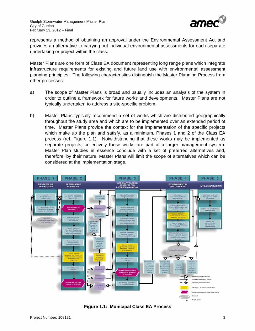
represents a method of obtaining an approval under the Environmental Assessment Act and provides an alternative to carrying out individual environmental assessments for each separate undertaking or project within the class. Master Plans are one form of Class EA document representing long range plans which integrate infrastructure requirements for existing and future land use with environmental assessment planning principles. The following characteristics distinguish the Master Planning Process from other processes: a) The scope of Master Plans is broad and usually includes an analysis of the system in
order to outline a framework for future works and developments. Master Plans are not typically undertaken to address a site-specific problem.
b) Master Plans typically recommend a set of works which are distributed geographically
throughout the study area and which are to be implemented over an extended period of time. Master Plans provide the context for the implementation of the specific projects which make up the plan and satisfy, as a minimum, Phases 1 and 2 of the Class EA process (ref. Figure 1.1). Notwithstanding that these works may be implemented as separate projects, collectively these works are part of a larger management system. Master Plan studies in essence conclude with a set of preferred alternatives and, therefore, by their nature, Master Plans will limit the scope of alternatives which can be considered at the implementation stage.
Figure 1.1: Municipal Class EA Process
Guelph Stormwater Management Master Plan City of Guelph February 13, 2012 – Final
Project Number: 108181 4
The City of Guelph Stormwater Management Master Plan has been prepared in accordance with the Municipal Engineers Association (MEA) Class Environmental (Class EA) procedures. The Master Plan has adopted Approach #1 in the 2007 MEA Documentation for all Schedule B projects. Approach # 1 involves the preparation of a Master Plan document at the conclusion of Phases 1 and 2 of the Municipal Class EA process. Approach # 1 addresses Phases 1 and 2 of the Class EA process (ref. Figure 1.1). Under Approach #1, Schedule B projects which are implemented in accordance with the recommendations provided in this Master Plan would require filing of a Project file for public review before the detailed design and implementation stages. The Stormwater Management Master Plan Study Terms of Reference outlined a detailed task-based work plan with the following primary tasks: Task 1: Study Area Profile Task 2: Define Goals and Objectives Task 3: Storm Sewer System and Water Quality Models Task 4: Alternatives Evaluation Task 5: Preferred Stormwater Management Strategy Task 6: Public Consultation Task 7: Implementation Plan Task 8: Stormwater Management Master Plan Report 1.3 Public/Agency Consultation As noted the Stormwater Management Master Plan is subject to the Class EA process, as such it has been conducted according to the requirements outlined in the Municipal Class EA process. The study approach has been established to meet the following objectives: i. Protection of the environment, including natural, social and economic components of the
environment. ii. Participation of a broad range of stakeholders in the study process to allow for sharing of
ideas, education, testing of creative solutions and developing alternatives. iii. Documentation of the study process in compliance with all phases of the Municipal Class
EA process. The Municipal Class EA requires notification of, and consultation with, relevant stakeholders. The Project Team has ensured that stakeholders were notified early in the planning process, and throughout the study. Figure 1.1 illustrates a simplified version of the Municipal Class EA process for this project.
Guelph Stormwater Management Master Plan City of Guelph February 13, 2012 – Final
Project Number: 108181 5
1.4 Schedule The study was initiated in December 2008. Project milestones have been met as follows: December 2, 2008 - Start-up Meeting. December 5, 2008 - Meeting and presentation to Community Design and Environmental Services (CDES) Committee by City Staff. January 23 & 30, 2009 - Notice of Commencement published in the Guelph Tribune newspaper, and mailed to agencies and stakeholders on the project contact list. January 2009 - Technical Advisory Committee (TAC) formed. March 2009 - Completion of background studies, Profile of study area and identification of need and justification for improvements. March 11, 2009 - Environmental Advisory Committee presentation and meeting (EAC) No.1 to request input to the Master Plan. March 27, 2009 - Consultation with the University of Guelph to obtain feedback on the purpose and objectives of the Guelph Stormwater Master Plan. May 22, 2009 - Technical Advisory Committee presentation and meeting No.1 to request input to the Master Plan. June 4 & 12, 2009 - Public Information Centre No.1 Notice (PIC No.1) was advertised on the City News page in the Guelph Tribune and mailed to agencies and stakeholders on the project contact list. June 15, 2010 - Technical Advisory Committee meeting No.2. June 17, 2009 - Hosting of PIC No.1. July 2010 - Completion of environmental inventories. August 2010 to January 2011 – Modeling of drainage networks January 19, 2011 - Technical Advisory Committee presentation and meeting No.3 to request input to the Master Plan. February 9, 2011 - Environmental Advisory Committee presentation and meeting No.2 to request input to the Master Plan. February 10 and 17, 2011 - Notification of second Public Information Centre (PIC No.2) advertised in the Guelph Tribune newspaper and mailed to agencies.

Guelph Stormwater Management Master Plan City of Guelph February 13, 2012 – Final
Project Number: 108181 6
February 24, 2011 - Hosting of PIC No.2. March 16, 2011 - River Systems Advisory Committee (RSAC) meeting to obtain input to the Master Plan. April 8, 2011 - Meeting with Grand River Conservation Authority staff to obtain input to the Master Plan. Spring 2011 - Documentation of set of recommendations. June 20, 2011 - CDES Committee Meeting, City Hall Council Chambers to present Draft Master Plan. February 2012 - Notice of Completion advertised in the Guelph Tribune newspaper for 30-day review period and mailed to agencies and stakeholders. Stormwater Management Master Plan placed on display for review. 1.5 Project Organization The development of this Master Plan has been directed and reviewed by a Project Team, which has been comprised of representatives from various departments at the City of Guelph and the Grand River Conservation Authority. A total of sixteen meetings have been convened with this Project Team during the course of this three-year study regarding the review and comment of the analyses completed for this study as well as the updates to the stormwater management policies. The Project Team consisted of staff from the following organizations: Proponent: City of Guelph Colin Baker, Project Manager, Environmental Engineer Rajan Philips, Transportation Planning Engineer Don Kudo, Infrastructure Planning, Design and Construction Manager Prime Consultant: AMEC Ron Scheckenberger, Project Manager Steve Chipps, Senior Project Engineer Matthew Senior, Water Resources Engineer Danny Stone, Environmental Planner Sub Consultants: Blackport & Associates- Bill Blackport, Sr. Hydrogeologist C. Portt & Associates- Cam Portt, Aquatic Biologist Dougan & Associates- Jim Dougan, Senior Terrestrial Ecologist Parish Geomorphic- John Parish, Senior Fluvial Geomorphologist D.C. Damman & Associates- Dianne Damman, Public Facilitator

Guelph Stormwater Management Master Plan City of Guelph February 13, 2012 – Final
Project Number: 108181 7
1.6 Reporting Overview This document represents the General Report for the City of Guelph Stormwater Management Master Plan. The report describes the background information, field reconnaissance and inventory of the City-managed stormwater management facilities, outlines the analyses of the City’s drainage system for existing development. Details regarding the analyses completed, including field photographs, hydrologic/hydraulic models, and calculations are provided within the respective appendices. The report outlines prioritized recommendations for drainage system upgrades and improvements, including potential areas for the application of Low Impact Development (LID) Best Management Practices (BMPs). Potential stormwater quality retrofits have been sited to provide quality controls for future infill and intensification. In addition, recommendations for a future more fulsome update to the City’s stormwater management policy have been updated under this process.
AMEC ENVIRONMENT &
INFRASTRUCTURE Ron Scheckenberger
Project Manager
AMEC Earth and
Environmental Steve Chipps Senior Project
Engineer
Dougan & Associates Jim Dougan
Senior Terrestrial Ecologist
C. Portt & Associates Cam Portt
Aquatic Biologist
Matthew SeniorWater
Resources Engineer
Blackport & Associates
Bill Blackport Sr.
Hydrogeologist
Danny StoneEnvironmental
Planner
D. C. Damman & Associate
Dianne Damman
Public Facilitator
City of Guelph Project Manager
Environmental Engineer
Technical Agencies Committee
GRCA, U of G, Engineering Consultants
PARISH Geomorphic John Parish
Senior Fluvial Geomorphologist
Guelph Stormwater Management Master Plan City of Guelph February 13, 2012 – Final
Project Number: 108181 8
1.7 Stakeholder and Agency Consultation 1.7.1 Phase 1 Consultation The City of Guelph Community Development and Environmental Services Committee was requested to endorse the proposed work plan for the Stormwater Management Master Plan on December 5, 2008. The Notice of Study Commencement and Invitation to Participate was circulated to Committee and Council on January 19, 2009. A Notice of Study Commencement, detailing the study area, summarizing the objectives of the study and requesting comments, was submitted to relevant stakeholders, property owners and organizations by mail. In addition, a Notice of Study Commencement was published by the City of Guelph in the Guelph Tribune newspaper January 23 & 30, 2009. A Technical Advisory Committee (TAC) was formed in January 2009. The TAC included representation from the Grand River Conservation Authority, University of Guelph, Local Engineering Firms, and the Guelph-Wellington Development Association. The TAC provided valuable input to the Master Plan during meetings held on three separate occasions on May 22, 2009, June 15, 2010 and January 19, 2011. An Internal Steering Committee consisting of City staff from Operations, Water Services, Wastewater Services, Policy Planning and Urban Design, and Engineering Services was also formed at the study onset to ensure the goals and objectives of the project were being met at all stages of the project and coordination opportunities across City departments were considered. City and Project staff met with the City’s Environmental Advisory Committee (EAC) on March 11, 2009 to review the Master Plan study and solicit input. On June 17, 2009, PIC#1 was held in the atrium of City Hall. The Public Information Centre Notice was advertised on the City News page in the Guelph Tribune on June 4 and 11, 2009 and it was mailed to agencies and stakeholders on the project contact list. The PIC was attended by individuals representing members of the public, academia, the Grand River Conservation Authority, engineering firms and the development industry all signing the register. Responses from the Notice of Commencement and PIC#1 were received from several stakeholders and agencies. Additionally, consultation meetings were held with agency representatives from the Grand River Conservation Authority. Copies of the newspaper advertisement, letters to stakeholders and agencies, copies of all comments received and written responses are contained in Appendix ‘A’.

Guelph Stormwater Management Master Plan City of Guelph February 13, 2012 – Final
Project Number: 108181 9
City of Guelph staff, agency staff and stakeholders who actively participated in consultation includes the following individuals:
Colin Baker Project Manager, Environmental Engineer, City of Guelph Dave Belanger City of Guelph Don Kudo City of Guelph Jessica McEachern City of Guelph Kime Toole City of Guelph Rachel Burrows City of Guelph Rajan Philips City of Guelph Sam Mattina City of Guelph Suzanne Young City of Guelph Carter Maguire City of Guelph Gus Rungis Grand River Conservation Authority Mark Anderson Grand River Conservation Authority John Palmer Grand River Conservation Authority Dr. Andrea Bradford TAC - University of Guelph Dr. Hugh Whitely TAC - University of Guelph- Emeritus Andrew Lambden TAC - Terra View Homes Gus Rungis TAC - Grand River Conservation Authority John Palmer TAC - Grand River Conservation Authority Jeremy Shute TAC - River Systems Advisory Committee Evelyn Allen TAC - Environmental Advisory Committee Chris Simms TAC - Gamsby Mannerow Tanya Lonsdale TAC - Braun Engineering
Website and Social Media Since 2008 the project website (www.guelph.ca/stormwater) has been well used by the public. . The Stormwater Management Master Plan WebPages were visited over 3,200 times throughout the duration of the project. The project website is promoted as the main source for all project information. For the works associated with this Master Plan the WebPages provide:
• Schedule of meetings and events; • Public contact information; • Upcoming meetings; • An online comment link as part of the public feedback; • PIC notices; • PIC presentation materials and display boards; • Reports; • Stormwater ponds in your neighbourhood, and • Stormwater terms and definitions.

Guelph Stormwater Management Master Plan City of Guelph February 13, 2012 – Final
Project Number: 108181 10
All communications with stakeholders and the public have included the website link in order to encourage use of the website. Social media such as Twitter has also been used to quickly update stakeholders and the public throughout the design and construction phases of the project. An online comment link to provide comments was available on the project website. When projects commence the site will serve to provide users with an easy method for submitting their comments, issues and concerns. The City’s Environmental Planner will log all feedback received through the website and respond in a timely manner. 1.7.2 Phase 2 Consultation Consultation with agencies and the public during Phase 2 of the Class EA process included several meetings with stakeholders and agencies, a Notice of Public Information Centre # 2, hosting Public Information Centre #2 and a Notice of Completion. The TAC provided further input to the Master Plan during the meeting held on January 19, 2011. City staff met with the City’s Environmental Advisory Committee (EAC) in February 9, 2011 to review the Master Plan study and solicit input. Agencies and stakeholders were notified of the opportunity for consultation via the Public Information Centre # 2 by letter and in the Guelph Tribune newspaper advertisement February 10 and 17, 2011. Public Information Centre Number 2 was held February 24, 2011 in the City of Guelph Atrium (ref. Appendix ‘A’). The purpose of PIC # 2 was to provide members of the public and interested agencies and stakeholders with the opportunity to review the findings and conclusions of Phase 2 of the study including alternative solutions considered the assessment process and present the preferred set of recommendations. Display boards were prepared to summarize the following: • Study Area; • Municipal Class EA Process; • Study Work Plan; • Study Goals and Objectives; • Previous Studies; • Assessment of Historic Flooding Sites; • Flooding Mechanisms; • Flood Management Alternatives; • Evaluation Criteria; • Planning Solutions Alternatives and Assessment; • Stormwater Quality Management for Urban Infill and Intensification; • Land Use; • Stormwater Management System Funding Alternatives;

Guelph Stormwater Management Master Plan City of Guelph February 13, 2012 – Final
Project Number: 108181 11
• Climate Change Considerations; • Stormwater Management Standards and Policy Review; • Next Steps, and • How to Provide Your Comments. Various drawings were also presented including the following: • Existing Conditions; • Downstream Flood Control ; • 5 and 100 Year Flooding Depths • Recommended Upgrade Alternatives; • Drainage Area Upgrade Priorities; • Stormwater Quality Retrofit Sites, and • Example Retrofit Ponds. AMEC staff gave a presentation on the preferred set of solutions/ recommendations, followed by a question and answer period. PIC #2 was well attended by members of the public. All comments received are attached in Appendix ‘A’. On April 8, 2011, the Project Team also met with Grand River Conservation Authority staff to discuss the proposed end-of-pipe stormwater retrofit sites and the criteria for prioritizing the stormwater management retrofit projects. A Council Meeting in City Hall Council Chambers was held June 20, 2011 to present the Master Plan and provide a presentation outlining the study findings and strategies. 1.7.3 Public Review of Stormwater Management Master Plan While the Master Plan addresses need and justification at a broad level, more detailed studies for each of the recommended projects included in the Master Plan will be required subsequent to the Municipal Class Environmental Assessment Master Plan Process. All parties having expressed an interest in the project have been notified by letter, regarding the completion of the study and filing of the Stormwater Management Master Plan. In addition, a Notice of Study Completion has been placed in the Guelph Tribune newspaper, and mailed to agencies and stakeholders in accordance with the requirements of the Class EA.

Guelph Stormwater Management Master Plan City of Guelph February 13, 2012 – Final
Project Number: 108181 12
Copies of the Master Plan will made available for 30 days for public review at the following locations: Clerk’s Desk, Guelph City Hall City Hall 1 Carden St Guelph, N1H 3A1 Ontario, Canada Phone: 519-837-5603 Monday to Friday- 8:30 a.m. to 4:00 p.m. Saturday and Sunday- Closed.
Guelph Public Library, Main Library 100 Norfolk Street Guelph, N1H 3A1 Ontario, Canada Phone: 519-824-6220 Monday to Friday- 9:00 a.m. - 8:00 p.m. Saturday- 9:00 a.m. - 5:00 p.m. Sunday- Closed.
Guelph Stormwater Management Master Plan City of Guelph February 13, 2012 – Final
Project Number: 108181 13
2. BACKGROUND INFORMATION AND STUDY AREA PROFILE Background information has been collected from the City of Guelph, Grand River Conservation Authority and others. A summary of the information collected to-date has been provided below. City of Guelph: Reports and Background Literature Documentation: • Watershed and Subwatershed Studies (Clythe Creek, Torrance Creek, Hanlon Creek,
Eramosa- Blue Springs) • Stormwater Management Reports, Drainage Studies, Environmental Impact
Assessments, Storm Sewer Design Reports (Approximately 200 documents, ref. Appendix ‘B’).
• Stormwater Management Facility Inventory, Assessment and Maintenance Needs Plan, Final Report, Totten Sims Hubicki, October 2008.
• Hydrogeological Studies Mapping and Inventory Data: • Digital topographic mapping (April 2006) • Aerial photography (April 2006), (ref. Drawing No. 2) • Existing and Official Plan land use • Stormwater management facilities and catchment areas • Municipal sewer inventory data • Drainage network mapping • Road system mapping • Property fabric • City of Guelph storm hyetographs GRCA: Mapping and Inventory Data: • Digital hydraulic models (Eramosa and Speed Rivers) • Regulatory flood line mapping • Drainage network mapping • Natural Heritage System information mapping • Regulatory wetland mapping • Soil and surficial geology mapping • Areas of Natural and Scientific Interest • Crest of Slope/ defined top of valley (Generic Regs.) Additional information on the City of Guelph’s Natural Heritage System has been provided by Dougan and Associates (ref. Appendices ‘H’ Natural Heritage Strategy).
Guelph Stormwater Management Master Plan City of Guelph February 13, 2012 – Final
Project Number: 108181 14
2.1 Land Use and City’s Strategic Growth Plan The Stormwater Management Master Plan has needed to consider both the existing (2008) land use (ref. Drawing No. 4) and the land use as prescribed in the current City of Guelph’s Official Plan. The current Official Plan was completed in 2001 (2006 Consolidation) with land use established by Schedule 1 Land Use Plan (ref. Drawing No. 5). The Official Plan (Schedule’s 2 through 9) also provides direction to City’s land use such as Schedule 8 Special Policy Area/ Flood Plain Land Use Plan along the lower Speed River from Gordon Street to the Hanlon Expressway. The City of Guelph is in the process of updating its current Official Plan, with the Phase 1 of the 2 Phase Official Plan in draft form as of 2010. The updated Official Plan has been scheduled to be completed in December 2011, therefore the Stormwater Management Master Plan has received input from the process to finalize the Official Plan such as the proposed City’s infill and land use intensification. In response to the provincial legislation Places to Grow Act 2005, the City of Guelph has developed the 2008 Growth Management Strategy. As part of the Strategy, the City has undertaken a residential intensification analysis to determine the City’s additional potential residential capacity within the existing city. The result of this Residential Intensity Analysis has determined that there is a potential for approximately 18,500 residential units or 46,250 additional residents within the City’s draft urban boundary and based on the 2031 timeframe. As most of this development will be infill and/ or intensification with minimal space for traditional stormwater quality management, the Master Plan has assessed opportunities to provide off-site stormwater quality management in the form of stormwater quality retrofits. 2.2 Aquatic Habitat All of the major watercourses (ref. Drawing No. 3) within the City have been classified by the MNR/GRCA with respect to fish communities (warmwater, coldwater or coolwater), however a local number of the smaller watercourses that have not been the subject of a subwatershed study have not. Hanlon and Clythe Creek are considered coldwater streams. Hadati Creek is considered a coolwater stream and the remainder of the watercourses are either warmwater streams or are unclassified. It is expected that most of the unclassified watercourses will provide warmwater habitat, however reconnaissance level fish sampling (electrofishing) would be required to be certain of their status. 2.3 Terrestrial Habitat A review of available background information has been performed to characterize the existing terrestrial habitat context of existing stormwater management facilities and their interaction with the surrounding Natural Heritage System of the City of Guelph.

Guelph Stormwater Management Master Plan City of Guelph February 13, 2012 – Final
Project Number: 108181 15
The following key documents have been reviewed as part of this background review: • Dougan & Associates, 2010, Guelph Natural Heritage Strategy • TSH, 2008, Stormwater Management Facility Inventory, Assessment and Maintenance
Needs Plan (prepared for City of Guelph) • Ministry of the Environment, 2003, Stormwater Management Planning and Design
Manual • Planning and Engineering Initiatives Ltd., et al., 2004, Hanlon Creek State of the
Watershed Report (prepared for City of Guelph and GRCA) • Beak International Inc. and Aquafor Beech Ltd., 1999, Eramosa-Blue Springs Watershed
Study • TSH et al., 1998, Torrance Creek Subwatershed Study (prepared for City of Guelph and
GRCA) • Weinstein Leeming et al., 1992, River Systems Management Study (prepared for City of
Guelph)
The Guelph Natural Heritage Strategy (2010) as part of the draft 2010 Official Plan Update (OPA # 42), contains a thorough review of local Environmental Impact Studies and other smaller-scale environmental reports published in the last 30 years that will be utilized for key natural heritage background information for this study, supplementing the watershed and subwatershed studies listed above. Overview of Natural Heritage in the City of Guelph Vegetation Communities The City of Guelph is located near the southern limit of the Great Lakes – St. Lawrence Forest Region, which is characterized by mixed forests of White Pine, Red Pine, Eastern Hemlock and Yellow Birch as well as Sugar Maple, Red Maple, Red Oak, Basswood and White Elm (Rowe 1972). Guelph is within the Manitoulin – Lake Simcoe Ecoregion, also know at 6E, and within the eastern end of the Stratford Ecodistrict (6E-1). The overall cover of wetlands and forests in Ecodistrict 6E-1 is currently estimated at 16%, with 33 species and three vegetation communities targeted as priorities for conservation. Within the City of Guelph, the percentage natural cover (defined as all natural and cultural cover, excluding lands being used for agriculture and other managed open spaces) is currently calculated to be just under 25%, of which less than half are considered to be fragments of original natural areas. A large portion of these remnants are wetland areas (i.e. swamps and marshes, as well as open water). In recognition of their importance, the OMNR has classified several of Guelph’s wetlands as provincially significant wetlands (Hanlon Creek Swamp, Speed River Wetland, Hall’s Pond Wetland, Torrance Creek Wetland Complex, Speed-Lutteral-Swan Creek Wetland Complex) (ref. Official Plan Schedule 10A: Natural Heritage Strategy ANSIs and Wetlands,). Those wetlands are part of natural area systems and form part of the City’s Natural Heritage System, which was approved by the Ministry of Municipal Affairs and Housing in February 2011, and are currently under appeal (ref. Official Plan Schedule 10: Natural Heritage Strategy Natural Heritage System,).
Guelph Stormwater Management Master Plan City of Guelph February 13, 2012 – Final
Project Number: 108181 16
Currently, the City’s forested cover (including cultural woodlands, plantations and swamps, which are forested wetlands) encompasses about 1100 ha (12%). When adjacent forested cover is combined, some of these forested areas are quite large (>60ha). These forested complexes provide interior forest habitat (100+ m away from any forest edge) that is rarely found in within the urban boundaries of most southern Ontario municipalities. Three provincially rare vegetation types (ELC) are reported to occur within the City’s wetlands and floodplain areas; these include Buttonbush Mineral Thicket Swamp (SWT2-4) in the NW portion of the Hanlon Creek Watershed, Silky Dogwood Mineral Thicket Swamp (SWT2-8) within the Guelph North-East Wetland complex and White Cedar Treed Carbonate Cliff (CLT1-1) located within the floodplains of the former Guelph Correctional Centre lands. Plant Species One plant Species-at-Risk (SAR) (i.e. designated as Endangered (END), Threatened (THR) or Special Concern (SC) at the provincial or national level) that has been recorded in Guelph since 1988 is the Butternut (Juglans cinerea). Further vegetation assessments must include the requirement to have all Butternut trees assessed for health by an OMNR-certified Butternut Health Assessor, and to protect all healthy trees. The City of Guelph NHS (2009) included a proposed Significant Plant List of 282 species (ref. Appendix ‘H’) of conservation concern whose habitats would require consideration as Significant Wildlife Habitat (OMNR 2000) as defined under the Provincial Policy Statement (2005). This list includes 46 provincially rare species, of which only 6 were observed in recent field work for the NHS and as part of other environmental impact studies within the City. If the Significant Plant List is adopted as policy, any future vegetation assessments, including the review of SWM facilities and natural areas impacted by storm water for this study, will be required to “flag locally significant species observations (in addition to provincially and federally significant species), but that the level and extent of associated habitat protection be determined on a case by case basis with consideration for each species’ needs.” (Guelph NHS, 2009) Wildlife The City of Guelph NHS (2009) also proposed a Significant Wildlife List which includes 286 species of conservation concern. None of the wildlife species observed during recent field work for the NHS are considered nationally or provincially rare, but a limited number of rare species have been noted as part of previous studies in the City. Note that the results of the NHS wildlife surveys should not be interpreted as comprehensive for the City because the surveys were focused on upland habitat (i.e. most designated wetlands in the City were not surveyed) and the limited time period (i.e. single season visits). This situation highlights the need to conduct more detailed wildlife studies in conjunction with any future subwatershed or environmental impact studies. The Significant Wildlife List has been adopted as policy as part of the Guelph NHS. All wildlife assessments are required to “flag locally significant species observations”, however only those species that are considered “rare” in Wellington County would “trigger areas for habitat protection through the criteria application for the Guelph NHS” (Guelph NHS, 2009).

Guelph Stormwater Management Master Plan City of Guelph February 13, 2012 – Final
Project Number: 108181 17
Stormwater Management Facilities and the City’s Natural Landscape Context The type and quality of terrestrial habitats provided by SWM facilities is highly dependent on location, age of facility, and type of structure. Those facilities that were constructed prior to the 1994 MOE guidelines which stressed water quality and quantity, controls, tended to have a utilitarian form with very little planted woody vegetation. More recently constructed facilities, in particular extended detention wet ponds and constructed wetlands, provide greater opportunities for increasing native species cover and diversity within the urban environment. There is some scientific concern that stormwater management ponds pose risks when they are utilized by wildlife as habitat (e.g., Bishop et al, 2000). It should be understood that the primary function of facilities is to serve as settling ponds for a wide range of pollutants (e.g., sand, road salt and oil from vehicles) that must be periodically managed to prevent toxic levels of contaminants from accumulating, and to maintain their intended infrastructural functions. However the placement of SWM facilities in the landscape is largely determined by the need to outlet to a receiving hydrologic system (i.e. watercourses), which are normally affiliated with terrestrial habitats of riparian, upland and wetland character. While there have been attempts in some jurisdictions to exclude wildlife from larger facilities through design or deterrent actions, there is now an extensive body of international literature documenting the use of SWM facilities by wildlife, as well as recent guidelines to assist in the design of facilities to promote safe use by wildlife. Increasingly, stormwater management is becoming more localized at the sources of runoff, and this is resulting in more discussion on the matters of aesthetics, habitat integration and public education within the facility design process. Studies have shown that stormwater facilities naturalized with native plants can provide habitat for both flora and fauna, and can contribute to local ecosystem biodiversity; however, their value as wildlife habitat may be limited and sometimes undesirable, with the possibility of human conflict and wildlife contamination. The high level of utilization of SWM facilities by wildlife is generally indicative of the shortage of natural habitats in urban areas. The role of the SWM facilities within the larger Natural Heritage System can benefit natural functions if planted and/or naturalized vegetation provides a buffer between natural areas and the surrounding urban areas. This role has been recognized in the Guelph NHS (2009); which identified storm water management ponds and infiltration facilities as naturalization / restoration areas, where they are in close proximity to significant natural features. Summary of Natural Heritage Relevance to Stormwater Facilities The background and guiding documents indicate the range of issues and potential conflicts that the planning, construction, operation and maintenance of SWM facilities may pose to the nearby natural environments. These issues include directs effects of construction, and indirect effects on local hydrology, water quality and hydroperiods which may affect existing habitats in the receiving system. Other indirect effects relate to the quality of habitats that are either intentionally created in facilities, or which evolve through natural succession irrespective of the original design intentions. As facilities become integrated as habitat, their intended periodic management may become problematic, if (for example) Species at Risk begin to utilize them, or habitats with other significant qualities and functions become established.

Guelph Stormwater Management Master Plan City of Guelph February 13, 2012 – Final
Project Number: 108181 18
2.4 Hydrogeology The background overview of hydrogeology is based primarily on a review of two recent studies: • Guelph-Puslinch Groundwater Study, (Golder, 2006); • Source Water Protection Project Groundwater Study - City of Guelph, (AquaResource
Inc./ Stantec Consultants, 2007). • City of Guelph Source Protection Project, Groundwater and Surface Water Vulnerability
Report, March 2010, AquaResource Inc. • City of Guelph Source Protection Project, Draft Water Quality Threats Assessment
Report, (AquaResource Inc., Stantec Consultants, 2010) These four studies provide the most recent summaries of the hydrogeological information as it relates to basic hydrogeological characterization. A more detailed hydrogeological study is currently being conducted by the City of Guelph and is expected to be released during 2012. This Tier 3 Source Protection Study will provide the most up to date characterization. As part of the Tier 3 Source Protection Study, the steering committee will develop a Discussion Paper describing the determined threats to source water. One of these threats will include stormwater management; hence there will be a need to develop a tool kit for addressing potential impacts on water quality from stormwater management. The Discussion Paper would ultimately inform the Source Protection Committee and the public on potential threats and opportunities from stormwater management. The City of Guelph will then follow-up with the best approaches to addressing its issues within its current setting. The discussion paper release is scheduled for April/May 2011 with consultation to occur through May to September, with the Source Protection Plan to be released in 2012. In addition, the Hanlon Creek State-of-the-Watershed Study (PEIL, 2004) was reviewed to potential trends in groundwater quality and quantity, which may relate to storm water management. Quaternary Geology The predominant surficial deposits within the city are permeable sand and gravel associated with glacial outwash, kames and eskers. Deposits of the Wentworth Till occur to the north and are associated with the Paris Moraine to the south. The Wentworth Till is a sandy-silt till in the Guelph area and has a potentially significant permeability. The Quaternary Geology can be found in Appendix ‘G’. These sandy silt or clay tills may also be found beneath the sand and gravel deposits. Bedrock out crops along the Speed and Eramosa Rivers. The overburden deposits thicken as one moves away from the rivers. The deposits are on the order of 10-20 metres to the north in the Guelph Drumlin field and increase from 10 to 40 metres as one moves south to the Paris Moraine.
Guelph Stormwater Management Master Plan City of Guelph February 13, 2012 – Final
Project Number: 108181 19
Paleozoic Geology and Municipal Wells The bedrock units underlying the City can be divided into the following: • Guelph Formation - light to medium brown, porous, vuggy dolostone; • Eramosa Member (Gasport Formation) - black, finely laminated bituminous dolostone
with black shale partings: • Gasport Formation – light bluish grey to white dolostone, with massive reefal structures
and fossiliferous beds. The majority of the City’s municipal wells obtain water from middle portion of the Gasport Formation which is highly fractured and contains large reefal cavities. This unit is either confined or semi-confined by the Eramosa Member. The shallow unconfined overburden aquifer is utilized at the Arkell Spring Grounds. Basic Hydrogeologic Setting Water from precipitation percolates or infiltrates into the ground until it reaches the water table. Areas where water moves downward from the water table are known as recharge areas. These areas are generally in areas of topographically high relief. Areas where groundwater moves upward to the water table are known as discharge areas. These generally occur in areas of topographically low relief, such as stream valleys. Groundwater that discharges to streams is the water that maintains the baseflow of the stream. Wetlands may be fed by groundwater discharge. There are different types and rates of recharge and discharge. Water percolating into the ground at a specific location may discharge to a small stream a short distance away. This is local recharge and local discharge. Some water may recharge a certain area and discharge to a larger river basin a long way from the source of recharge. This is known as regional recharge and regional discharge. Permeable geologic materials through which groundwater moves are known as aquifers. Aquifers are "water bearing" formations meaning that water can be easily extracted from these units. The less permeable units are known as aquitards, and although water can move through these units, it moves slowly and it is difficult to extract water from these units. How these aquifers are connected within a hydrogeologic setting is what controls much of the movement of groundwater. A delineation of the flow system(s) in this way will identify where groundwater originates, where it discharges and the most prominent paths it travels between these points (e.g. the aquifer pathways or more permeable hydrostratigraphic units). Having done this, one can assess the relative sensitivity of the linkage from the groundwater system to the aquatic or terrestrial systems. Knowing the level of sensitivity of the receptor one can determine the impacts of particular types and scales of land uses or land use changes on the groundwater flow system and other linked ecosystem components. Best management practices can then be developed to prevent unacceptable impacts from occurring.

Guelph Stormwater Management Master Plan City of Guelph February 13, 2012 – Final
Project Number: 108181 20
Throughout the City significant recharge will occur in areas where there are more permeable sediments and the within the elevated, depressional topography of the Paris Moraine. This water may move through the shallow flow system to more local reaches of water courses or in some cases to local wetlands. This shallow flow is more predominant where the overburden unit overlying the bedrock is a less permeable till. Where the permeable overburden is connected to the shallow bedrock recharge will move into bedrock flow system. The amount of water moving to the deeper bedrock and the municipal well production unit of the middle portion of the Gasport Formation depends, in part, on the thickness and characteristics of the Eramosa Member and the upper portion of the Amabel Formation. A quantification of the shallow groundwater flow within the City was not currently available. It is understood this is due to lack of shallow monitoring well data and it is not known to what extent this will be refined in the Tier 3 study to be released in 2012. That being said, the Arkell Spring Grounds collector system collects shallow groundwater from overburden and conveys the collected water to the F.M Woods Water Treatment Plant. In addition The City recharges the overburden by pumping water from the Eramosa River during April to November, to augment groundwater flow and provide for the increase in water demand during those months. The Carter Wells also obtain water supply from shallow bedrock in the Guelph Formation which is not protected by an aquitard and is more susceptible to potential contamination. Deeper groundwater flow is collected from the Gasport Formation is basically controlled by the pumping of the municipal wells and their associated capture zones. 2.5 Surface Water Quality A 'desktop' assessment of available data has been conducted to determine the relative conditions of Guelph's open waterways. Surface water quality data and background characterization information has been provided by the City of Guelph for the Hanlon Creek, Torrance Creek, Eramosa River and Clythe Creek, specifically as follows: Hanlon Creek The Hanlon Creek, State of the Watershed Study, September 2004, PEIL, provides the results of a long-term water quality monitoring program (1991-2001). Water quality monitoring was conducted based on the terms established within the Hanlon Creek Watershed Plan, (Marshall Macklin Monaghan Limited, January 1991). The water quality monitoring objectives were to: • Assess existing water quality and establish realistic targets compatible with stream use • Identify pollution sources and recommend control measures • Set-up long-term water quality monitoring.
Surface water quality monitoring results established that low concentrations of total suspended solids existed at each of the monitoring locations. Concentrations of phosphates and most metals were also considered to be low based on monitoring results. The Clairflields Subdivision 2002-2004 Monitoring Program determined that the concentration of nitrate exceeded the 1991 target of 3.0 mg/L. It is not known if mitigative measures to improve upon the Nitrate concentrations have been conducted.

Guelph Stormwater Management Master Plan City of Guelph February 13, 2012 – Final
Project Number: 108181 21
Torrance Creek The Torrance Creek Monitoring Program, (Draft), June 2000, Stantec Consulting Ltd. states that a five year monitoring program was to be conducted, including groundwater, surface water, terrestrial and environmental monitoring. It is not know if the monitoring program commenced as no subsequent reports following the year 2000 have been made available. Prior to the 2000 Monitoring Program Report, the Torrance Creek Subwatershed Study Phase 1 Characterization Report, June 1998, Totten Sims Hubicki, noted that the greatest impediment to the surface water quality of Torrance Creek are the on-line ponds. Invertebrate sampling results downstream of the Victoria Park Golf Club (West) pond demonstrated a decline in overall surface water quality. It has been recommended that Ponds ‘A’ and ‘D’ be taken off-line, while riparian cover and/or vegetation should be implemented at Ponds ‘B’ and ‘E’. Clythe Creek The 1997 Clythe Creek Subwatershed Overview, Ecologistics Limited, notes that flashy flows due to urban development have resulted in creek bank erosion and degradation of aquatic habitat. The reports recommend upland vegetation along the creek corridor to improve upon aquatic habitat and stream stability. Eramosa River The Eramosa-Blue Springs Watershed Study, October 1999, Beak International Incorporated, Aquafor Beech Limited, Mark L. Dorfman, Stantec Engineering, indicates that there was little evidence of surface water quality deterioration based on monitoring commencing in the 1970’s. Surface water quality monitoring results established that nutrient and trace contaminant concentrations remained constant or improved slightly. In addition to the foregoing, stream temperatures have remained relatively unchanged. More detailed monitoring results are provided below: • General chemistry parameters indicated excellent water quality: high dissolved oxygen
levels, low chloride levels and low suspended sediments levels. • Bacteria counts were low, well below the Provincial Water Quality Objectives (PWQOs)
with one monitoring result exception, suggesting that sources of untreated animal and/or human waste were not concerns.
• Nutrient concentrations are low, particularly phosphorus which is within the PWQOs, • Trace metals levels are also within PWQOs including copper, lead and cadmium. Zinc
concentrations exceeded the PWQOs near the mouth of the Eramosa River. On-going Surface Water Quality Monitoring The GRCA has conducted low flow surface water quality monitoring during the winter and spring of 2009 on the lower Speed River, Eramosa River and the Hanlon Creek (ref. Appendix ‘D’). The study was conducted in 2008 but was not able to obtain results due to the wet weather conditions.

Guelph Stormwater Management Master Plan City of Guelph February 13, 2012 – Final
Project Number: 108181 22
The winter sampling began on January 19, 2009 at 8 sites and was concluded on March 15, 2009 to represent spring conditions. Sampling was conducted for Chloride, BOD, Total Ammonia, Unionized Ammonia, TKN, Nitrite, Nitrate, Total Phosphorus, Phosphate, and Suspended Solids. GRCA has yet to provide conclusions and recommendations on the winter\spring monitoring program. Recommendations may include further monitoring and mitigative measures. 2.6 Groundwater Quality Groundwater quality in both the overburden and the bedrock is of the calcium-magnesium-bicarbonate type water and are generally high in total dissolved solids (TDS). Higher total dissolved solids are found in the deeper bedrock systems where the residence time of the groundwater has been longer. Elevated levels of sodium and chloride found in a number of wells may be indicative of road salt. Iron is relatively high within the bedrock due to its composition. 2.7 Streamflow/Creek Systems In order to gain a better understanding of the effects that future growth will have on the natural environment, the City of Guelph has undertaken an assessment to identify stream corridors with excessive erosion. The geomorphic components of the study primarily focused on a desktop analysis of existing geomorphic conditions within the City of Guelph. This work optimized the existing available information already available for each subwatershed within the City, including existing subwatershed, stormwater management and drainage studies, geographic information and aerial photography. Building on the work presented within the numerous background reports, reaches were confirmed, refined or delineated for each of the major watercourses in the study area. Building upon the findings of the background review, areas of concern with respect to creek bank erosion was identified. The process essentially entailed a sensitivity analysis undertaken in a GIS environment and involved developing a list of controlling parameters, such as sinuosity, gradient and land use, which was then used to scope any subsequent analyses on reaches which are most sensitive to erosion processes. In addition, these parameters were used to develop an estimate of stream power using GIS techniques to determine reach sensitivity and erosive potential. This analysis was then cross-referenced with aerial photography and background resources in order to confirm and refine the list of erosion sites. Based on the analysis described above, ground truthing of the sensitive reaches was conducted. During this time, any areas of erosion were documented through a combination of documentation, photographs and GPS coordinates. Any issues of structural damage due to erosion were also noted. All of the information was incorporated in the project database (ref. Appendix ‘C’). Prior to the initiation of the geomorphic assessment, a review of background reports was conducted to determine any relevant information that may be applicable to the specific study.
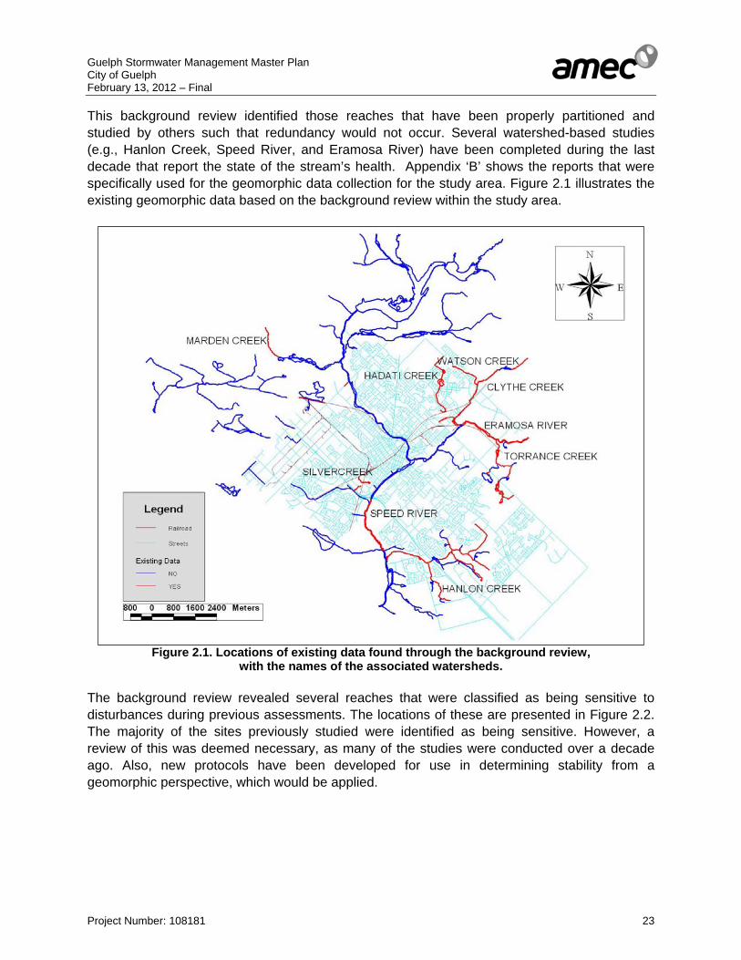
Guelph Stormwater Management Master Plan City of Guelph February 13, 2012 – Final
Project Number: 108181 23
This background review identified those reaches that have been properly partitioned and studied by others such that redundancy would not occur. Several watershed-based studies (e.g., Hanlon Creek, Speed River, and Eramosa River) have been completed during the last decade that report the state of the stream’s health. Appendix ‘B’ shows the reports that were specifically used for the geomorphic data collection for the study area. Figure 2.1 illustrates the existing geomorphic data based on the background review within the study area.
Figure 2.1. Locations of existing data found through the background review, with the names of the associated watersheds.
The background review revealed several reaches that were classified as being sensitive to disturbances during previous assessments. The locations of these are presented in Figure 2.2. The majority of the sites previously studied were identified as being sensitive. However, a review of this was deemed necessary, as many of the studies were conducted over a decade ago. Also, new protocols have been developed for use in determining stability from a geomorphic perspective, which would be applied.

Guelph Stormwater Management Master Plan City of Guelph February 13, 2012 – Final
Project Number: 108181 24
Figure 2.2. Streams identified as sensitive based on the background review. Given the large size of the study area and the numerous creeks that are situated within it, the streams in City of Guelph were divided into reaches in order to identify sensitive areas more precisely. A reach is a length of channel displaying similar physical characteristics, such as sinuosity, gradient or valley form. Reach length will vary with channel scale since the morphology of low-order channels will vary over a smaller distance than higher order watercourses. Reaches are typically several hundred meters long and can extend to as much as two kilometers in length. Utilizing topographic mapping, air photos, geology maps and field observations, reaches were identified for all the study area (ref. Figure 2.3).
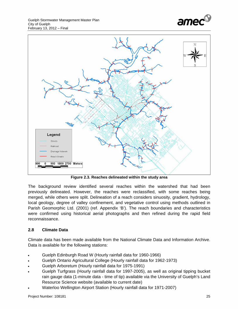
Guelph Stormwater Management Master Plan City of Guelph February 13, 2012 – Final
Project Number: 108181 25
Figure 2.3. Reaches delineated within the study area The background review identified several reaches within the watershed that had been previously delineated. However, the reaches were reclassified, with some reaches being merged, while others were split. Delineation of a reach considers sinuosity, gradient, hydrology, local geology, degree of valley confinement, and vegetative control using methods outlined in Parish Geomorphic Ltd. (2001) (ref. Appendix ‘B’). The reach boundaries and characteristics were confirmed using historical aerial photographs and then refined during the rapid field reconnaissance. 2.8 Climate Data Climate data has been made available from the National Climate Data and Information Archive. Data is available for the following stations: • Guelph Edinburgh Road W (Hourly rainfall data for 1960-1966) • Guelph Ontario Agricultural College (Hourly rainfall data for 1962-1973) • Guelph Arboretum (Hourly rainfall data for 1975-1991) • Guelph Turfgrass (Hourly rainfall data for 1997-2005), as well as original tipping bucket
rain gauge data (1-minute data - time of tip) available via the University of Guelph’s Land Resource Science website (available to current date)
• Waterloo Wellington Airport Station (Hourly rainfall data for 1971-2007)
Guelph Stormwater Management Master Plan City of Guelph February 13, 2012 – Final
Project Number: 108181 26
• Elora Research Station (3 separate datasets: Hourly rainfall data for 1970-1993, 1986-2003, and 2003-2007 respectively)
• Fergus Shand Dam (Hourly rainfall data for 1960-2007) • Preston WPCP (Hourly rainfall data for 1970-1996) • Cambridge Galt MOE ((Hourly rainfall data for 1971-1992) Hourly temperature data and snowfall data are recorded at Toronto International Pearson Airport, among other local stations. In addition to the foregoing, meteorological data from GRCA has been obtained for the Guelph Lake and Speed River Road 32 gauges. The gauges records hourly rainfall, daily rainfall, daily snowfall, daily total precipitation and daily minimum and maximum temperatures. Although not climate data, GRCA has also provided stream flow data as part of this study. Most of the long term gauges in the Guelph area are operated by the Water Survey of Canada and the data is available for download from the WEB. GRCA operates a gauge on the Speed River at Victoria Road, however it is affected by weeds and not corrected for ice. There also is some stream flow data on smaller water courses with short records from short term studies. The City of Guelph has provided its Design Storm hyetographs used in establishing peak flow rates for the 5 and 100 year storm events (ref. Appendix ‘E’). 2.9 Infrastructure The City of Guelph’s stormwater management infrastructure includes, storm sewers, overland drainage systems (swales, ditches, creeks, rivers and crossings etc.) and stormwater management facilities. A general description of the systems and information available is provided below. Storm Sewers: Most of the urbanized area of the City of Guelph is serviced by a storm sewer system (ref. Drawing No. 6) typically designed to convey the 5 year storm flows. The City has a GIS linked database that provides storm sewer and maintenance chamber details. Overland Drainage Systems The rural and employment districts are typically serviced by overland drainage systems such as roadside ditches. The employment district in north Guelph is serviced by ditches which eventually discharge to various storm sewer systems designed to convey the 100 year storm event peak flow. The other main component of the overland drainage system are the various creeks, watercourses, and rivers traversing the City.

Guelph Stormwater Management Master Plan City of Guelph February 13, 2012 – Final
Project Number: 108181 27
Stormwater Management Facilities An extensive amount of reporting has been collected from the City of Guelph, including just fewer than 200 Stormwater Management or related Reports. Drainage area mapping associating each stormwater management facility (where appropriate) to the design drainage area has been completed (ref. Drawing 6). A comprehensive review of all stormwater management reporting provided has been conducted to complement the Stormwater Management Facility Inventory, Assessment and Maintenance Needs Plan, October 2008. The Stormwater Management Facility Inventory, Assessment and Maintenance Needs Plan report provides an inventory of the 100 (+/-) existing stormwater management facilities within the City of Guelph. The stormwater management facilities have been categorized into three groups, dry, wet and greenway facilities. The majority of the existing stormwater management facilities are located within southern Guelph with only a few located north of the Speed and Eramosa Rivers. The report outlines maintenance requirements based on design report data and field reconnaissance. A database was also provided containing such information as facility drainage area, inlet details and impervious coverage, etc. (ref. Appendix. ‘F’).
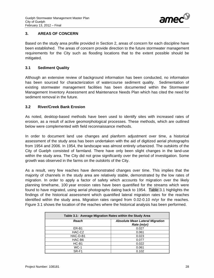
Guelph Stormwater Management Master Plan City of Guelph February 13, 2012 – Final
Project Number: 108181 28
3. AREAS OF CONCERN Based on the study area profile provided in Section 2, areas of concern for each discipline have been established. The areas of concern provide direction to the future stormwater management requirements for the City such as flooding locations that to the extent possible should be mitigated. 3.1 Sediment Quality Although an extensive review of background information has been conducted, no information has been sourced for characterization of watercourse sediment quality. Sedimentation of existing stormwater management facilities has been documented within the Stormwater Management Inventory Assessment and Maintenance Needs Plan which has cited the need for sediment removal in the future. 3.2 River/Creek Bank Erosion As noted, desktop-based methods have been used to identify sites with increased rates of erosion, as a result of active geomorphological processes. These methods, which are outlined below were complemented with field reconnaissance methods. In order to document land use changes and planform adjustment over time, a historical assessment of the study area has been undertaken with the aid of digitized aerial photographs from 1954 and 2006. In 1954, the landscape was almost entirely urbanized. The outskirts of the City of Guelph consisted of farmland. There have only been slight changes in the land-use within the study area. The City did not grow significantly over the period of investigation. Some growth was observed in the farms on the outskirts of the City. As a result, very few reaches have demonstrated changes over time. This implies that the majority of channels in the study area are relatively stable, demonstrated by the low rates of migration. In order to apply a factor of safety which accounts for migration over the likely planning timeframe, 100 year erosion rates have been quantified for the streams which were found to have migrated, using aerial photographs dating back to 1954. Table 3.1 highlights the findings of the historical assessment which quantified lateral migration rates for the reaches identified within the study area. Migration rates ranged from 0.02-0.10 m/yr for the reaches. Figure 3.1 shows the location of the reaches where the historical analysis has been performed.
Table 3.1: Average Migration Rates within the Study Area Reach Absolute Mean Lateral Migration
Rate (m/yr) ER-B1 0.027
HAC-C2 0.061 HAC-D-B1 0.023 HAC-B6 0.077 HC-B1 0.022 WC-1 0.061 SR-F1 0.102

Guelph Stormwater Management Master Plan City of Guelph February 13, 2012 – Final
Project Number: 108181 29
Figure 3.1. Location of reaches that migrated during 1954 to 2006. Ferencevic (2008) outlined a procedure of using stream power as a surrogate for channel stability and integrating it into a Geographic Information System (GIS). This procedure involved the mapping of the reaches, and creating a Digital Elevation Model (DEM) based on the elevation isolines. A flow direction algorithm is applied to the DEM, which assigns a direction code to each cell that signifies the direction in which water would flow. Flow accumulation can be determined from the flow direction image – the number of consecutive cells flowing into one another is added so that areas of convergent flow and streams have increasingly high flow accumulation values in the downstream direction. Discharge can be approximated using a discharge-area relationship and the flow accumulation image. This can then be used to determine the stream power within the system. The results of this analysis are presented in Figure 3.2. The points with the highest stream power have been circled. The results, as expected, depict the areas with the highest stream power to be those further downstream, where there is the most accumulation of flow. This analysis has been useful to predict potentially problematic and unstable sites.
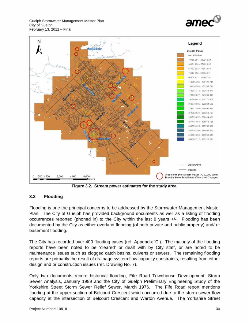
Guelph Stormwater Management Master Plan City of Guelph February 13, 2012 – Final
Project Number: 108181 30
Figure 3.2. Stream power estimates for the study area. 3.3 Flooding Flooding is one the principal concerns to be addressed by the Stormwater Management Master Plan. The City of Guelph has provided background documents as well as a listing of flooding occurrences reported (phoned in) to the City within the last 8 years +/-. Flooding has been documented by the City as either overland flooding (of both private and public property) and/ or basement flooding. The City has recorded over 400 flooding cases (ref. Appendix ‘C’). The majority of the flooding reports have been noted to be ‘cleared’ or dealt with by City staff, or are noted to be maintenance issues such as clogged catch basins, culverts or sewers. The remaining flooding reports are primarily the result of drainage system flow capacity constraints, resulting from either design and or construction issues (ref. Drawing No. 7). Only two documents record historical flooding, Fife Road Townhouse Development, Storm Sewer Analysis, January 1989 and the City of Guelph Preliminary Engineering Study of the Yorkshire Street Storm Sewer Relief Sewer, March 1976. The Fife Road report mentions flooding at the upper section of Belcourt Crescent which occurred due to the storm sewer flow capacity at the intersection of Belcourt Crescent and Warton Avenue. The Yorkshire Street
Guelph Stormwater Management Master Plan City of Guelph February 13, 2012 – Final
Project Number: 108181 31
report indicates that the trunk sewer along Yorkshire Street was under capacity and as a result a relief storm sewer was constructed. In addition to the City of Guelph’s information, the GRCA has provided Regulatory floodlines along each of the regulated watercourses within the City limits (ref. Drawing No. 7). The older development areas along the lower Speed River and Eramosa River are located within the Regulatory floodplain and as such could be flooded in the future. A more detailed assessment of flood levels for the lesser storm events would be required to determine which storm frequency would flooding occur. 3.4 Groundwater Levels/Well Head Protection Areas Stormwater management for the City has the challenge to maintain recharge to provide water to the municipal aquifer(s) and to maintain the groundwater flow system’s discharge function to surface water features. Groundwater quantity and quality must be considered for both of these functional linkages. Groundwater Levels As discussed in Section 2.4, a detailed quantification of the water table within the City is not known. Limited groundwater level monitoring data within the Hanlon Creek watershed commonly indicates water levels within the upper 2 metres of ground surface. Of note in Hanlon Creek State-of-the-Watershed Study is that the limited qualified assessment for the period 1992-2001 indicates: • Groundwater levels had remained stable and • The stormwater management facilities generally appeared to be successfully infiltrating. Two factors to consider when assessing the maintenance of groundwater levels are the reduction in recharge due to development and the potential drop in the water table due to municipal pumping. A potential water table drawdown map due to pumping is presented in Appendix ‘G’. It is expected that the recharge/discharge characterization will be refined to some extent in the Tier 3 study expected to be finalized in 2012. This may provide input into the assessment for the more local utilization of stormwater management. Wellhead Protection Areas Detailed studies have quantified wellhead protection areas and aquifer vulnerability, the most recent being the Source Water Protection Project Groundwater Study. The modeled capture zones can be found in Appendix ‘G’. This figure shows the captures zones for the various wells and associated times of travel to the wells. It can be seen that the majority of the City is within the associated capture zones. The potential of degraded infiltrating water impacting the municipal water supply is assessed in part by considering the vulnerability of the aquifers. A semi-quantitative vulnerability map

Guelph Stormwater Management Master Plan City of Guelph February 13, 2012 – Final
Project Number: 108181 32
associated with the capture zones is presented in Appendix ‘G’. The vulnerability is generally high for the City. The assessment with respect to stormwater management has focused in part on the potential contaminants and the ability of those contaminants to be attenuated prior to reaching the municipal aquifer. One of the major challenges is the high mobility of sodium and chloride within the groundwater flow system. Short circuiting of contaminants to the groundwater flow system, in particular the bedrock, raises the potential for contamination of the municipal aquifer. As part of the Source Water Protection Project Groundwater Study an additional vulnerability map was prepared taking into account preferential pathways including sewer systems intersecting the bedrock. This map can be found in Appendix ‘G’.
Guelph Stormwater Management Master Plan City of Guelph February 13, 2012 – Final
Project Number: 108181 33
4. FIELD INVESTIGATIONS Field investigations have been conducted to not only provide additional data for the study area profile, but to establish conditions that can be incorporated into the stormwater management assessment. Field data on minor/major system conditions provides potential reasons for reported observed flooding. Field observations on stormwater management facilities have been used to confirm findings of The Stormwater Management Facility Inventory, Assessment and Maintenance Needs Plan (Totten Sims Hubicki, 2008) and to evaluate potential stormwater quality retrofit sites. Stream erosion assessment has been conducted to provide general direction on the need for stormwater erosion control for future development, although it is noted that independent studies would have to assess the required receiving system to determine actual erosion control requirements. The monitoring of rainfall and flow levels at storm sewer outlets has provided calibration data for the hydrologic and hydraulic modelling. 4.1 Stormwater Management Infrastructure Minor/ Major Drainage System Field inspection has been conducted for 43 critical flooding locations. Critical flooding locations throughout the City have been defined as overland flooding of either the road system (i.e. urban collector or arterial roads) and/ or multiple private properties resulting from non-maintenance issues (ref. Appendix ‘C’ and Drawing No. 7). The majority of sites that have been field inspected have one or more of the following observations: • grading issues such as low curbs which allow road flooding onto private property • no or insufficient catch basins • clogged catch basins • clogged or undersized culverts • unknown flooding mechanism • reverse slope driveways • roadway sags
Hydrologic and hydraulic modeling in subsequent tasks has been conducted to evaluate flooding at critical flooding locations and evaluate potential flood prevention measures. Storm Management Facilities The Stormwater Management Facility Inventory, Assessment and Maintenance Needs Plan (Totten Sims Hubicki, 2008) has outlined those facilities that have minor and major concerns. Minor concerns have been considered such as glass clipping being dumped, odour concerns and animal borrows. Major concerns have been considered as washout of outlet channel or structure, erosion of facility sides, poor vegetation quality. Based on the facility inventory 74 facilities out of the 100 had some form of deficiency. Facilities with erosion or wash out included Nos. 4 and 94. Facilities with washouts included. 51, 67, 88, 93, 35, 13 and 99. Facilities 2 and 52 were noted as having grates and maintenance chamber covers removed. Field inspection of the critical facilities was undertaken as part of this study with the following findings:

Guelph Stormwater Management Master Plan City of Guelph February 13, 2012 – Final
Project Number: 108181 34
• Conditions at inspected stormwater management facilities have not changed from those documented within the 2008 Stormwater Management Facility Inventory
• Various stormwater management facilities classified as dry facilities in fact based on filed observations actually have permanent standing water.
4.2 Natural Environment 4.2.1 Stream Reaches Various stream reaches have been selected from the study area, on which to conduct fieldwork (ref. Appendix ‘C”). The sites identified as sensitive through the background review has been selected, as well as those that has been found to have high values of stream power, based on the GIS desktop analysis. For example, HAC-7, a reach in Hanlon creek has been classified as sensitive in the background review, but also has showed a high stream power through the GIS analysis. In contrast, SR-I2, a tributary to the Speed River has been selected for the primary purpose of examining the condition of a stream flowing through an urban setting that had not been studied earlier. The initial component of the fieldwork entailed reconnaissance of the identified reaches. During the reconnaissance, any areas of substantial erosion were mapped and rapid assessments were completed (e.g., Rapid Geomorphic Assessment and Rapid Stream Assessment Technique). A Rapid Geomorphic Assessment (MOE, 1999) documents observed indicators of channel instability. Observations are quantified using an index that identifies channel sensitivity to aggradation, degradation, channel widening and planimetric adjustment. The index produces values that indicate whether the channel is in regime/stable (<0.20), stressed/transitional (0.21-0.40) or adjusting (>0.41). The Rapid Stream Assessment Technique provides a broader view of the system by also considering the ecological functioning of the stream (Galli, 1996). Observations include instream habitat, water quality, riparian conditions, and biological indicators. RSAT scores rank the channel as maintaining a low (<20), moderate (20-35) or high (>35) degree of stream health. Additionally, the RSAT approach includes rough measures of bankfull channel dimensions, type of substrate, vegetative cover, and channel disturbance. A photographic appendix is included to provide additional context. RGA and RSAT scores are provided in Table 4.1, along with a reach-by-reach description of the study area.
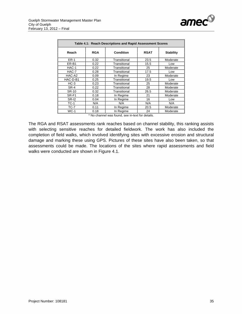
Guelph Stormwater Management Master Plan City of Guelph February 13, 2012 – Final
Project Number: 108181 35
Table 4.1: Reach Descriptions and Rapid Assessment Scores
Reach RGA Condition RSAT Stability
ER-1 0.32 Transitional 23.5 Moderate ER-B1 0.22 Transitional 15.5 Low HAC-1 0.22 Transitional 25 Moderate HAC-7 0.28 Transitional 17.5 Low
HAC-A2 0.09 In Regime 23 Moderate HAC-D-B1 0.25 Transitional 19.5 Low
HC-3 0.23 Transitional 25 Moderate SR-4 0.22 Transitional 28 Moderate
SR-10 0.32 Transitional 26.5 Moderate SR-F1 0.18 In Regime 21 Moderate SR-I2 0.04 In Regime 16 Low TC-1* N/A N/A N/A N/A TC-7 0.11 In Regime 20.5 Moderate WC-1 0.18 In Regime 24 Moderate
* No channel was found, see in-text for details. The RGA and RSAT assessments rank reaches based on channel stability, this ranking assists with selecting sensitive reaches for detailed fieldwork. The work has also included the completion of field walks, which involved identifying sites with excessive erosion and structural damage and marking these using GPS. Pictures of these sites have also been taken, so that assessments could be made. The locations of the sites where rapid assessments and field walks were conducted are shown in Figure 4.1.

Guelph Stormwater Management Master Plan City of Guelph February 13, 2012 – Final
Project Number: 108181 36
Figure 4.1. Locations of reaches identified for conducting fieldwork. Reach ER-1 This reach was located in the Eramosa River, where bankfull dimensions ranged from 8.5-12 m in width and 0.7-1 m in depth. There was no apparent riffling in this reach, and the substrate in the pools in this reach was found to consist of silt and coarse sand. The channel was found to be moderately entrenched, with bank angles ranging from 40-80 degrees. A culvert with circular wing walls was being undermined. Widening was determined to be the dominant process affecting this reach. Supporting evidence includes the presence of fallen trees, occurrence of large organic debris, and basal scour on the inside of meander bends. Reach ER-B1 Reach ER-B1 was part of a tributary flowing into the Eramosa River. The bankfull dimensions ranged from 0.1-3 m in width and 0.3-0.5 m in depth. The riffles in this tributary were undefined as well, and the substrate in the pools consisted of fine, medium, and coarse sand. The channel was found to be slightly entrenched, with bank angles ranging from 15-40 degrees. There are several small culverts and footpath crossings over the channel, with manicured lawns and trails nearby. There were three different geomorphic processes affecting this reach, with aggradation,

Guelph Stormwater Management Master Plan City of Guelph February 13, 2012 – Final
Project Number: 108181 37
widening and planform adjustment occurring here. Evidence for these include siltation in pools and the presence of medial bars for aggradation, fallen and leaning trees and the occurrence of large organic debris for widening, and the formation of chutes and a single thread channel giving way to multiple channels as evidence for planform adjustment. Reach HAC-1 Reach HAC-1 is the downstream part of Hanlon Creek that flows into the Speed River. In this reach, the bankfull width was found to range from 4.5-8.5 m, and the bankfull depth ranged from 0.3-0.6 m. Pool and riffle substrate differed substantially from silt and medium to coarse sand, and coarse sand to pebbly material, respectively. The entrenchment in this channel was found to be low, with bank angles ranging from 10-20 degrees. There is a deer conservation park at the downstream end of the reach. Immediately upstream of this park, the channel splits into multiple channels with islands, and there are trees growing within the channel. There were large amounts of woody debris and fallen trees as well. Aggradation was determined to be the dominant process affecting this reach, as is evident from the lateral bars and mid-channel bars observed, siltation in pools, and the evidence of deposition in and around structures. Reach HAC-7 Reach HAC-7 was located in Hanlon Creek, where the bankfull dimensions ranged from 5-10 m in width and 0.45-0.75 m in depth. The riffle substrate in this reach consisted of silt, but no pools were found. The channel was found to be moderately entrenched, with bank angles of 30-70 degrees observed. The channel banks are lined with leaning trees, and there are large amounts of woody debris on the banks and within the channel. There are uprooted trees in the channel as well. While these characteristics suggest widening is an active process in this channel, the formation of chutes and islands, and a single thread channel forming multiple channels indicates that planform adjustment is the dominant geomorphic process affecting this reach. Reach HAC-A2 This reach forms part of a tributary to Hanlon Creek. The bankfull dimensions for this reach were found to range from 2.5-3 m in width and 0.4-0.5 m in depth. The substrate in both pools and riffles consisted of coarse to very coarse sand, and pebbles. The channel was moderately entrenched, with bank angles ranging from 30-60 degrees. This is a well-vegetated channel, with tall herbs and grasses and scattered shrubs in the channel. Degradation was the dominant geomorphic process affecting this reach, as there is a marked absence of any depositional features. HAC-D-B1 HAC-D-B1 is a tributary that flows into Hanlon Creek, with bankfull dimensions range from 1.5-3.5 m in width to 0.3-0.5 m in depth. This reach did not have defined riffles, but the pool substrate consisted of silt and organic material. Entrenchment in this channel was low, with bank angles of 50-80 degrees. A 1.5 m tall weir has created a wetland, and the channel downstream of this is narrow with plenty of woody debris and fallen trees. The section of the
Guelph Stormwater Management Master Plan City of Guelph February 13, 2012 – Final
Project Number: 108181 38
channel flowing through a meadow is almost dry, and appears to be an overflow channel to fill the wetland. Widening is the dominant process affecting this channel, as there are fallen trees, organic debris in the channel, exposed tree roots, and basal scour. HC-3 This reach is a section of Hadati Creek, which is a tributary to Clythe Creek. The channel is characterized by bankfull dimensions of 2-3.5 m in width and 0.3-0.6 m in depth. The pool and riffle substrate varied substantially from sands ranging from the fine end of the spectrum to very coarse in the pools, and gravel in the riffles. Entrenchment is moderate, with bank angles ranging from 25-40 degrees. The channel is lined with gabion baskets in sections, and large boulders are placed in bends to minimize erosion. There is some undercutting in those sections where there is scour. Widening was found to be the dominant process affecting this channel. Evidence supporting this conclusion included the presence of fallen and leaning trees, the occurrence of large organic debris and exposed tree roots in sections. SR-4 SR-4 is a large reach in the Speed River, and has bankfull dimensions ranging between 26-65 m in width and 0.6-1.2 m in depth. The substrate differs significantly from silt and coarse sand in the pools, to the larger 5-20 cm sized bed material and large boulders found in the riffles. Entrenchment is moderate, with bank angles ranging from 15-60 degrees. There is a very natural section along this channel with good riffles and pools. There is a sewage treatment plant on the right bank and a quarry on the left bank at the upstream end of the reach. Aggradation was determined to be the dominant process affecting this channel. Evidence for this includes the presence of lobate and medial bars. SR-10 This reach is a section of the Speed River, with bankfull dimensions of 7-12 m in width and 0.5-1 m in depth. The substrate in the pools consisted of medium sand and pebbles ranging between 2-5 cm, while coarse sand and pebbles ranging from 15-25 cm were found in the riffles. Entrenchment is moderate in this channel, with bank angles of 50-80 degrees. Planform adjustment was determined to be the dominant process affecting this channel, based on evidence provided by the formation of chutes, a single channel forming multiple channels and the formation of islands in the channel. SR-F1 SR-F1 forms part of a tributary to the Speed River. The bankfull dimensions of this reach range from 6-7 m in width, to 0.8-1 m in depth. The substrate in the pools and riffles differ substantially from silt and medium and coarse sand, to medium and coarse sand and cobbles, respectively. Entrenchment was moderate for this reach, with bank angles ranging from 45-70 degrees. The banks of the channel are lined with large stones, and basal scour is observed along the left bank of the reach in some sections. There were several leaning and fallen trees observed, with cases of exposed tree roots above the channel as well. Large organic debris was also found. All these suggest that widening was the dominant process affecting this reach.

Guelph Stormwater Management Master Plan City of Guelph February 13, 2012 – Final
Project Number: 108181 39
SR-I2 This reach is a part of a tributary that flows into the Speed River. The channel was found to have a bankfull width ranging from 5-6 m and a bankfull depth ranging from 0.6-0.9 m. The riffles in this channel were ill-defined, but the substrate in the pools consisted of silt and fine sand. Entrenchment was moderate, with bank angles of 30-50 degrees. The channel runs through a confined constructed ditch, where a townhouse complex lined by fencing forms the left bank and a manicured park forms the right bank. Algae cover much of the bed material. Aggradation was determined to be the dominant geomorphic process, as there was siltation in pools. TC-1 This reach forms the downstream part of Torrance Creek, a tributary flowing into the Eramosa River. However, no channel was found during the field investigation; there were only a series of ditches and culverts running along the side of the road. It is assumed that the water is diverted through these culverts into the Eramosa River. TC-7 This reach is a part of Torrance Creek, where the bankfull dimensions were determined to be 1-8 m in width and 0.3-0.6 m in depth. Entrenchment in this channel was low, with bank angles ranging from 10-30 degrees. The riffles in this channel were ill-defined, and the pool substrate consisted of silt, coarse and very coarse sand, and pebbles. This channel flows through a golf course, where the banks of the channel are well manicured with several small crossings. The creek flows downstream into a marshy area with fallen trees and algae and dense shrubbery. Widening was determined to be the dominant geomorphic process in this reach, as there were fallen trees and large organic debris present. WC-1 WC-1 is a reach at the downstream end of Watson Creek, a tributary of Clythe Creek. The channel is characterized by bankfull dimensions ranging from 0.6-1.2 m in width, and 0.25-0.3 m in depth. The substrate in the pools and riffles differ from combination of fine sand, medium sand and silt in the former to a combination of fine sand, medium sand and 2-5 cm pebbles in the latter. Entrenchment was moderate, with bank angles ranging from 30-70 degrees. The channel runs along a low lying scrub and forested area. It is densely vegetated at the upstream end, with a well-defined pool and riffle morphology. There is evidence of planform adjustment in this channel, based on the formation of chutes, the evolution of the pool-riffle form to a low bed relief form, and the formation of islands. Summary The rapid assessment results indicated that the identified reaches in the study area were generally in a state of transition. This is likely because the channels have completed adjusting in response to earlier changes in land use and flow regimes, and are gradually stabilizing. There were some reaches within the study area that were quite stable, supporting this hypothesis.

Guelph Stormwater Management Master Plan City of Guelph February 13, 2012 – Final
Project Number: 108181 40
However, while these findings do provide meaningful results, a more qualitative approach would involve the detailed examination of some of the reaches identified as being sensitive through the rapid assessments. 4.2.2 Terrestrial Habitat Upon examination of the location of the stormwater management facilities that are adjacent to or connected with the Natural Heritage System, it has been determined that most of the existing stormwater management facilities within the City meet that criteria, with only 10 +/- (ten) not meeting the criteria. As such there are 88 +/- (eighty-eight) stormwater management facilities adjacent to or connected to the Natural Heritage System. Based on the foregoing field investigation of each of the 88 + /- facilities has not been feasible under the terms and scope of this study. As such, a sample of 15 storm water ponds representing all the pond types were surveyed to assess how ponds were interacting with existing natural areas within the city of Guelph. All but one of the surveyed ponds were selected from those originally included by TSH (2008). The extra site that was included in the survey was adjacent to Pond # 50. Of the 15 storm water facilities surveyed, four were dry ponds, five were wet ponds, and six were greenways/channels. A rapid assessment of the habitat quality of each of the sample SWF was carried out, which included a survey of vegetation, fauna, and signs that the associated flora and fauna were interacting with, or have the potential to interact with neighboring natural areas. Vegetation Structure The upland section of almost all ponds had greater than 50% cover and in most cases cover was 90-100%. The primary source of non-vegetated area was gravel trails running adjacent to or surrounding the ponds. The dominant type of vegetation in the non-aquatic sections of ponds was ground cover from herbaceous species, grasses, and shrubs. Trees typically formed less than 10% of the upland cover at any given pond. Open water was primarily associated with the wet ponds and the channel, however, two ponds that were designated as dry had substantial amount of open water. In the wet ponds, open water was predominantly shallow, with some ponds having up to 25% deep open water. Open water in the channel was entirely shallow water. Unfortunately, the Team’s ability to determine the amount of shallow versus deep open water in the dry ponds was limited by access or pond size. Emergent (e.g. Typha spp.), submergent (e.g. Potomogeton spp.), and floating-leaved (e.g. Lemna spp.) were present at all wet ponds. The channel had only submerged or emergent vegetation. The dry ponds had predominantly emergent vegetation. Vegetation Communities The vegetation community at each SWF was broadly grouped into either (i) planted/seeded, (ii) naturally occurring and non-native or early successional, or (iii) naturally occurring and native.

Guelph Stormwater Management Master Plan City of Guelph February 13, 2012 – Final
Project Number: 108181 41
Overall, evidence that vegetation had been planted or seeded was more likely to be observed in ponds and greenways/channels that had been constructed more recently. In dry ponds, the vegetation community tended to be naturally occurring and non-native or early successional. Communities tended to be dominated by native and exotic cultural meadow forbs and grasses. In one case, the dominance of Typha spp. resulted in the pond being listed as having vegetation naturally occurring and native. Woody vegetation associated with dry ponds tended to be native and exotic Salix spp. and Rhamnus spp. Vegetation in wet ponds was a mix of naturally occurring and non-native or early successional plants, or had been planted/seeded. The aquatic vegetation community tended to include Typha spp., Lemna spp., and a few other emergents (e.g. Sagittaria sp. and Alissma sp.). Although non-indigenous species such as Lythrum salicaria, Phramites australis, and Butomus umbellatus were present at these ponds, at the time of surveying, they were not very abundant. Upland communities tended to be dominated by native and exotic cultural and wet meadow forbs and grasses. Woody vegetation tended to include native and exotic Salix spp., Fraxinus americana, and Cornus sericea. In some cases woody vegetation was likely planted, and not naturally occurring. Greenway and channel vegetation was a mix of naturally occurring and non-native or early successional plants, or had been planted/seeded. The aquatic vegetation community, when it was present, consisted of native grasses and sedges that were likely planted. In some sites, non-indigenous species such as Lythrum salicaria and Phragmites australis were present, but not at high abundance. Upland communities tended to be dominated by non-indigenous cultural meadow grasses and forbs, however native species such as Solidago canadensis and Erigeron spp. were present at most sites. Woody vegetation tended to included native and exotic Salix spp., Cornus sericea, Rhus typhina, and Acer saccharinum. Although most other trees were native, they tended to be planted. Ground-level vegetation in the channel was primarily a mix of native and non-native cultural and wet meadow grasses and forbs. The non-native Lythrum salicaria was abundant in patches along the edge of the channel. Woody vegetation was a mix of native (e.g. Cornus sericea) and non-native (Rhamnus spp.) shrubs, and native trees. Overall, the recent development of these SWF made it more likely to observe vegetation that had been planted or seed, when compared to wet and dry ponds. Human Disturbance Human disturbance across all ponds was low to moderate. Disturbances tended to be low in dry ponds, moderate in wet pond, low in greenways, and moderate in the channel. Low-level disturbances tended to include gravel trails adjacent to ponds that facilitated pedestrian traffic, municipal maintenance, and encroachment (e.g. dumping of yard waste and mowing by homeowners adjacent to, or slightly within designated pond areas). Moderate disturbances included off-leash dogs, adjacent roadways (traffic and noise), and dumped trash. Interactions/Connectivity of SWM Ponds & Natural Areas The degree to which ponds and natural areas influence one another will likely be affected by their proximity to one another, physical barriers, ecological barriers, vegetation connectivity,

Guelph Stormwater Management Master Plan City of Guelph February 13, 2012 – Final
Project Number: 108181 42
open water connectivity, and ground water connectivity. In general, natural areas were more likely to influence storm ponds than vice-versa. There were however, aspects of storm pond drainage that likely resulted in some storm ponds influencing adjacent natural areas. For example in one pond, open water drained directly into an adjacent provincially significant wetland (PSW). The majority of ponds in the survey sample were adjacent to natural areas (9 of 15), one was within 50 m, three were 50-100m, and two were over 100m. In all cases where ponds were adjacent to natural areas, they were also connected by vegetation. In three cases there was no connectivity of pond and natural areas by vegetation. This occurred when ponds were either 50-100m or greater than 100m from the closest natural area. In most cases (12 of 15) ponds were separated from natural areas by some form of physical barrier. The majority of these barriers were rather minor, and included silt fencing, berms, or gravel paths. In some cases, barriers were more substantial and included galvanized fencing and roadways. Impacts of these barriers, however, are expected to depend on the mobility of wildlife attempting to utilize the pond areas. For example the movement of amphibians and reptiles between ponds and natural areas is unlikely to be impacted by galvanized fencing, but would likely be greatly impacted by roadways. On the contrary, movement by birds is unlikely to be limited by any of the observed physical barriers between natural areas and the storm ponds, provided suitable habitat is present. The Team evaluated the potential for ecological barriers to exist between stormwater management ponds and natural areas based on the similarity/dissimilarity of general habitat type. Habitat type was only similar in 5 of 15 ponds. Where habitats were dissimilar, the main reasons were that ponds had open water and natural areas were upland, or ponds were open and natural areas were forested. Despite these ecological differences in habitat type, the heterogeneity created by storm ponds may be an important factor for some wildlife. For example, leopard frogs utilizing wetland natural areas for breeding will subsequently migrate to dry upland areas later in the season to forage. Where flora and fauna occupying natural areas rely of very specific habitat type, ponds that differ will be less attractive to local wildlife; whereas wildlife that depend on habitat heterogeneity will likely do well in ponds that differ in vegetation from natural areas. Storm water ponds were only connected to natural areas by open water in four of the 15 cases. Two were associated with dry ponds, and the other two with greenways. The first instance of open water connectivity with a dry pond resulted from a small stream running from the associated natural area, through the dry pond, and into an adjacent greenway. The second resulted from a linear floodway that runs adjacent to the associated natural area, and connected with the outlet of the dry pond. Open water connectivity observed within the greenways occurred at same greenway location. Open water from the greenway flowed through a constructed pond before draining (via a culvert) into the adjacent natural area which is listed as a PSW and a cold water fishery. It was difficult to evaluate if ponds were connected to natural areas by ground water. Further work needs to be done using hydrology maps to determine if ponds, particularly those that are designed to infiltrate, do actually feed ground water associated with natural areas.
Guelph Stormwater Management Master Plan City of Guelph February 13, 2012 – Final
Project Number: 108181 43
Acting as a Buffer Where storm ponds are constructed between developed and natural areas, they have the potential to buffer natural areas from human disturbance. The majority (9 of 15) of storm water ponds did offer some kind of buffer between developed and natural areas. This tended to be the case for dry and wet ponds, and less so for greenways, where spatial design constraints leave little opportunity for buffers. Where ponds did act as buffers they provided a semi-natural transition between urban versus natural habitat, and they diverted pedestrian traffic away from natural areas. Where ponds were not acting as buffers, they tended to be small relative to the natural area, or were situated such that they were not constructed directly between a developed and natural area. This was the primary reason greenways and channels did not function as buffers; their spatial design as linear corridors within developed areas is less likely to result in a stormwater management pond that would act as effective buffers between developed and natural areas. Fauna & Functionality The functionality of storm water ponds as natural habitat should depend on factors that deter versus entice, or are detrimental versus beneficial for local wildlife. The occurrence of some form of wildlife at all of the ponds that were surveyed indicates that storm ponds are acting as natural habitat. The quality of habitat, however, varied quite substantially among ponds. A variety of birds, amphibians, reptiles, and invertebrates were observed using ponds. Dry ponds tended to have bird species typically associated with old-field and open habitats including Song Sparrow and American Goldfinch. Wet ponds had similar bird species to dry ponds, but included Red-Winged Black Bird, Canada Goose, and Mallard. At one of the wet ponds, a Belted Kingfisher was observed foraging and feeding on minnows. In another wet pond, two species of sandpiper were observed foraging on mudflat shoreline areas. Dry and wet ponds with open water also attracted aerial insectivores such as Barn Swallows. Greenways and the channel also had similar bird species as dry ponds. A sandpiper species was also observed at the channel location, presumably foraging on the exposed mud shoreline. All wet ponds and two of the greenways had at least one frog species present. One wet pond had a turtle species present. Although not identified to species, all ponds had a variety of invertebrate fauna that included bees, wasps, dragonflies, damselflies, crickets, katydids, butterflies, and moths. Animal trails, tracks, and burrows indicated that most ponds were also being utilized by mammals. Factors deterring wildlife tended to include ponds being surrounded or adjacent to developed areas, small area, pedestrian traffic, fencing, and the presence of non-native vegetation. Factors enticing wildlife tended to include the heterogeneity of habitat that was created by ponds and open water. Detriments to species using pond areas tended to include adjacent roadways, dumped trash, and the presence of domestic animals. Some ponds with open water also seemed to be slightly eutrophic. Benefits to species using pond areas tended to include sufficient habitat for safety (e.g. shrub cover), breeding habitat for birds and amphibians, and availability of open water. Section 6.1.5.9.2 of OPA #42 identifies criteria for designating restoration areas, including existing and new storm water management areas abutting the Natural Heritage System. The

Guelph Stormwater Management Master Plan City of Guelph February 13, 2012 – Final
Project Number: 108181 44
following objectives and policies have been established for restoration areas as part of the Natural Heritage System: Objectives 1. To identify opportunities for restoration throughout the City, including opportunities to
increase and/or maintain open meadow landscapes for pollinators, birds and other wildlife to ensure diversity within the Natural Heritage System.
2. To identify areas where replacement trees and shrubs will be focused in conjunction with Tree Compensation Plans.
3. To provide opportunities to increase the City’s tree canopy cover. Policies 1. Development and site alteration shall not be permitted within Restoration Areas except
for the uses permitted by the General Permitted Uses of Section 6.1. 2. In addition to the uses permitted by the General Permitted Uses of Section 6, storm
water management facilities and their normal maintenance, and renewable energy systems may be permitted.
3. The primary use of the lands within the Restoration Areas will be restoration and existing or approved storm water management facilities and their normal maintenance.
4. Opportunities for restoration on public and private lands abutting the Natural Heritage System beyond those identified in Schedule 10 will be encouraged.
5. Outside active stormwater management facilities, Restoration Areas may be maintained, restored or managed to provide habitat for birds, butterflies, and other insects that play an important role in pollination.
6. New Restoration Areas may be added without an amendment to this Plan where new stormwater management facilities are approved in accordance with the provisions of this Plan and are located adjacent to the Natural Heritage System.
7. The City will undertake a study to prioritize and develop a management plan for Restoration Areas in the City.
4.3 Field Monitoring of Rainfall and Runoff Continuous flow and rainfall data for the purpose of calibrating and verifying the hydrologic drainage network modelling has been initiated on June 25, 2010 and ended on December 3, 2010. The locations of the various flow monitoring locations are summarized below, and shown on Drawing I1 (Appendix ‘I’). Two rounds of water level/flow monitoring have been conducted, with four sites per round. Round One Flow Monitoring (June 25 to September 21, 2010) • Willow West (WW06) • Stone Road (LS05) • Railway (LS02) – 2 loggers • Waverly (US03)

Guelph Stormwater Management Master Plan City of Guelph February 13, 2012 – Final
Project Number: 108181 45
Round Two Flow Monitoring (September 21, 2010 to December 3, 2010) • North West Channel (NW04) • Ward 1 (HD02) • Schroder (HD02) • Woodlawn (US10) Data Loggers at these locations (Solinst Leveloggers) recorded observed water levels at 5 minute increments, with barometric correction data applied from another of AMEC’s monitoring program sites. A geodetic survey was conducted to obtain a cross-section and channel profile at all locations. Periodic in-stream velocity measurements were also taken throughout the monitoring program to enable the calculation of observed flow – surface water level elevations. These elevations were then used to fit a rating curve, based on the previously noted surveyed cross-sections and the hydraulic modeling program HEC-RAS v.4.0. Detailed data and results have been provided in Appendix ‘I’. In addition to the flow monitoring, a project rainfall gauge was installed on the roof of the new City Hall (ref. Drawing I1) for the entire duration of the monitoring program. The total depth of rainfall recorded between June 25, 2010 and December 3, 2010 was 428.2 mm. During that monitoring period twenty (20) storm events with a total depth greater than 5 mm were observed, with twelve (12) of those storm events having a total depth greater than 10 mm. The details of these particular storm events are presented in Table 4.2.
Table 4.2: Significant Observed Rainfall Events between June 25 and December 3, 2010
Date Depth (mm)
Duration (hrs)
Average Intensity (mm/hr)
Maximum Intensity (mm/hr)
June 27, 2010 38.0 3.33 11.9 72.0 July 9, 2010 15.0 3.83 4.3 14.4
July 11, 2010 17.2 0.42 41.3 76.8 July 23, 2010 17.6 3.00 5.9 43.2
September 3, 2010 28.0 1.33 21.1 79.2 September 16, 2010 25.2 6.58 3.8 19.2 September 28, 2010 24.4 8.92 2.7 9.6
October 5, 2010 11.4 5.17 2.2 7.2 October 14, 2010 17.6 5.08 3.5 12.0 October 26, 2010 11.4 3.25 3.5 43.2
November 16, 2010 19.0 5.58 3.4 9.6 December 1, 2010 14.8 8.08 1.8 4.8
As evident from the storm data in Table 4.2, several significant storm events were recorded, in particular the June 27, July 11, September 3, and September 28 2010 storm events. The September 3, 2010 storm event specifically was noted to have caused significant flooding across the City of Guelph, mostly in areas with historical flooding problems. Based on the data provided in Table 4.2, it is evident that there are numerous suitable storm events for model calibration and verification. Full monitoring program results, including graphs of observed water level and developed rating curves, have been included in Appendix ‘I’. The data is also discussed in greater detail as part of the calibration effort, as detailed in Section 5.2.4.
Guelph Stormwater Management Master Plan City of Guelph February 13, 2012 – Final
Project Number: 108181 46
It should be noted that data from the Willow West monitoring site is only available to August 13, 2010. Sometime between August 13 and September 10, 2010, the monitoring data logger was either vandalized or dislodged by high flows. Notwithstanding, a sufficient number of major storms were captured during this period to allow for a suitable calibration. A second data logger was installed at the railway site (Network LS02) on July 8, 2010 due to concerns noted by the City of Guelph that under significant storm events, the existing twin culverts within the CNR lands could be overtopped, resulting in a loss of flow from the downstream channel. As such, data from both the original location (downstream of the culverts) and the additional location (upstream of the culverts) was collected. Based on the collected data, it was determined that no events sufficient to overtop the culverts occurred during the monitoring period. The data from the second data logger was therefore used as a verification on the primary data logger’s data. It should be noted that flow data from the Ward 1 site was not used as part of the model calibration effort. Due to an undersized outlet, extensive backwater effects were evident in this location. An approximate storage-based rating curve was attempted from the data, however it was considered that this approach did not sufficiently account for the channel spill at the upstream end towards the adjacent property, hence it was not pursued.
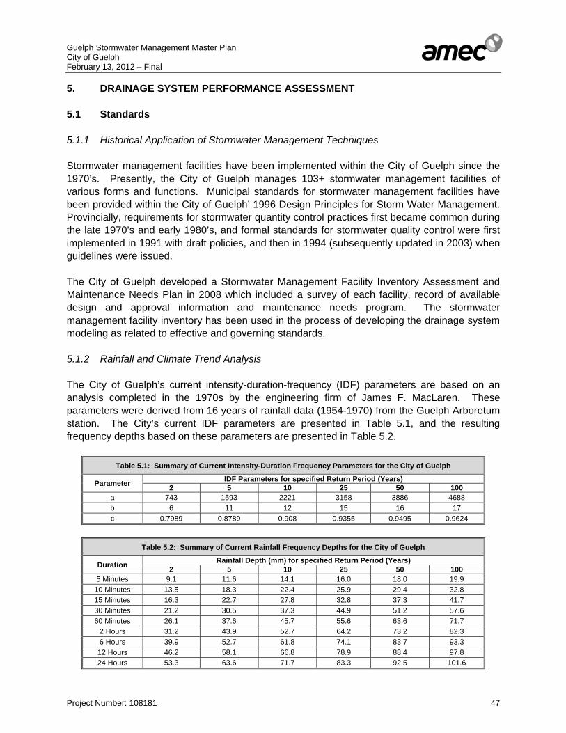
Guelph Stormwater Management Master Plan City of Guelph February 13, 2012 – Final
Project Number: 108181 47
5. DRAINAGE SYSTEM PERFORMANCE ASSESSMENT 5.1 Standards 5.1.1 Historical Application of Stormwater Management Techniques Stormwater management facilities have been implemented within the City of Guelph since the 1970’s. Presently, the City of Guelph manages 103+ stormwater management facilities of various forms and functions. Municipal standards for stormwater management facilities have been provided within the City of Guelph’ 1996 Design Principles for Storm Water Management. Provincially, requirements for stormwater quantity control practices first became common during the late 1970’s and early 1980’s, and formal standards for stormwater quality control were first implemented in 1991 with draft policies, and then in 1994 (subsequently updated in 2003) when guidelines were issued. The City of Guelph developed a Stormwater Management Facility Inventory Assessment and Maintenance Needs Plan in 2008 which included a survey of each facility, record of available design and approval information and maintenance needs program. The stormwater management facility inventory has been used in the process of developing the drainage system modeling as related to effective and governing standards. 5.1.2 Rainfall and Climate Trend Analysis The City of Guelph’s current intensity-duration-frequency (IDF) parameters are based on an analysis completed in the 1970s by the engineering firm of James F. MacLaren. These parameters were derived from 16 years of rainfall data (1954-1970) from the Guelph Arboretum station. The City’s current IDF parameters are presented in Table 5.1, and the resulting frequency depths based on these parameters are presented in Table 5.2.
Table 5.1: Summary of Current Intensity-Duration Frequency Parameters for the City of Guelph
Parameter IDF Parameters for specified Return Period (Years) 2 5 10 25 50 100
a 743 1593 2221 3158 3886 4688 b 6 11 12 15 16 17 c 0.7989 0.8789 0.908 0.9355 0.9495 0.9624
Table 5.2: Summary of Current Rainfall Frequency Depths for the City of Guelph
Duration Rainfall Depth (mm) for specified Return Period (Years) 2 5 10 25 50 100
5 Minutes 9.1 11.6 14.1 16.0 18.0 19.9 10 Minutes 13.5 18.3 22.4 25.9 29.4 32.8 15 Minutes 16.3 22.7 27.8 32.8 37.3 41.7 30 Minutes 21.2 30.5 37.3 44.9 51.2 57.6 60 Minutes 26.1 37.6 45.7 55.6 63.6 71.7
2 Hours 31.2 43.9 52.7 64.2 73.2 82.3 6 Hours 39.9 52.7 61.8 74.1 83.7 93.3
12 Hours 46.2 58.1 66.8 78.9 88.4 97.8 24 Hours 53.3 63.6 71.7 83.3 92.5 101.6

Guelph Stormwater Management Master Plan City of Guelph February 13, 2012 – Final
Project Number: 108181 48
An IDF update analysis was completed in May 2007 by EarthTech (City of Guelph – Ward One, Frequency Analysis of Maximum Rainfall and IDF Curve Update). That report updated the period of record to 1954-2003, including filling several data gaps with data from the nearby Waterloo Wellington Airport station, when data from Guelph was not available (either the Arboretum or Turfgrass Institute stations). A comparison of these updated frequency depths to the City’s current values (based on the original 1954-1970 analysis) found that the updated values were generally lower, on the order of 10 to 15% (with the difference varying with return period). This is likely due to the inclusion of major storm events in 1954 (Hurricane Hazel) and 1968 in the original time series, over a relatively short period of record. Based on this analysis, City of Guelph staff has indicated that they intended to retain the current IDF parameters, based on the 1954-1970 analysis, in order to be consistent with previous design, and to add a factor of safety. The 2007 report (City of Guelph – Ward One, Frequency Analysis of Maximum Rainfall and IDF Curve Update) cited literature which indicated support for a 15% increase in Rainfall depth in Canada under future climate change conditions. The report therefore concluded that retaining the City of Guelph’s current IDF parameters would account for this impact. The report also recommended that the City continue to update their IDF curves on a 5 year basis. As part of the Stormwater Master Plan process, a review of current rainfall data has been conducted, with the intent of performing a climate trend analysis. The City of Guelph has indicated that it does not require another complete IDF update, based on the findings of the 2007 report. However, in order to perform an accurate climate trend analysis, rainfall maxima have been updated to include more current data (2004-2010). Several different data sources have been employed: • Environment Canada’s updated daily rainfall maxima (for 5, 10, 15, 30 minutes, and
1, 2, 6, and 12 hours) for the Guelph Turfgrass and Waterloo Wellington A stations (currently updated to 2005 and 2007 respectively)
• Original tipping bucket rain gauge data (1-minute data - time of tip) for the Guelph Turfgrass station, available via the University of Guelph’s Land Resource Science website (available to current date)
• Grand River Conservation Authority’s hourly rainfall data for the Guelph Lake station (2001 – 2010)
• AMEC/City of Guelph 5-minute rainfall data for the City Hall gauge, installed during the 2010 monitoring program (as described in Section 4.3 and Appendix ‘I’)
Due to data gaps, and rainfall gauges which missed several significant storm events in the City of Guelph (such as the July 22, 2008 and September 3, 2010 events), it has been necessary to rely on data from a number of different sources as indicated above. For years where the GRCA’s Guelph Lake gauge was employed, no values have been included for the 5, 10, 15, and 30 minute periods, as the gauge records only hourly data. A summary of the resulting annual maximum series of rainfall (1954-2010) is included in Appendix ‘E’. The common conclusion of climate change studies is that rainfall amounts and intensities are generally increasing, as a warmer, moister atmosphere allows for stronger storm systems. Although the City of Guelph does not require a complete IDF update (as noted previously), it
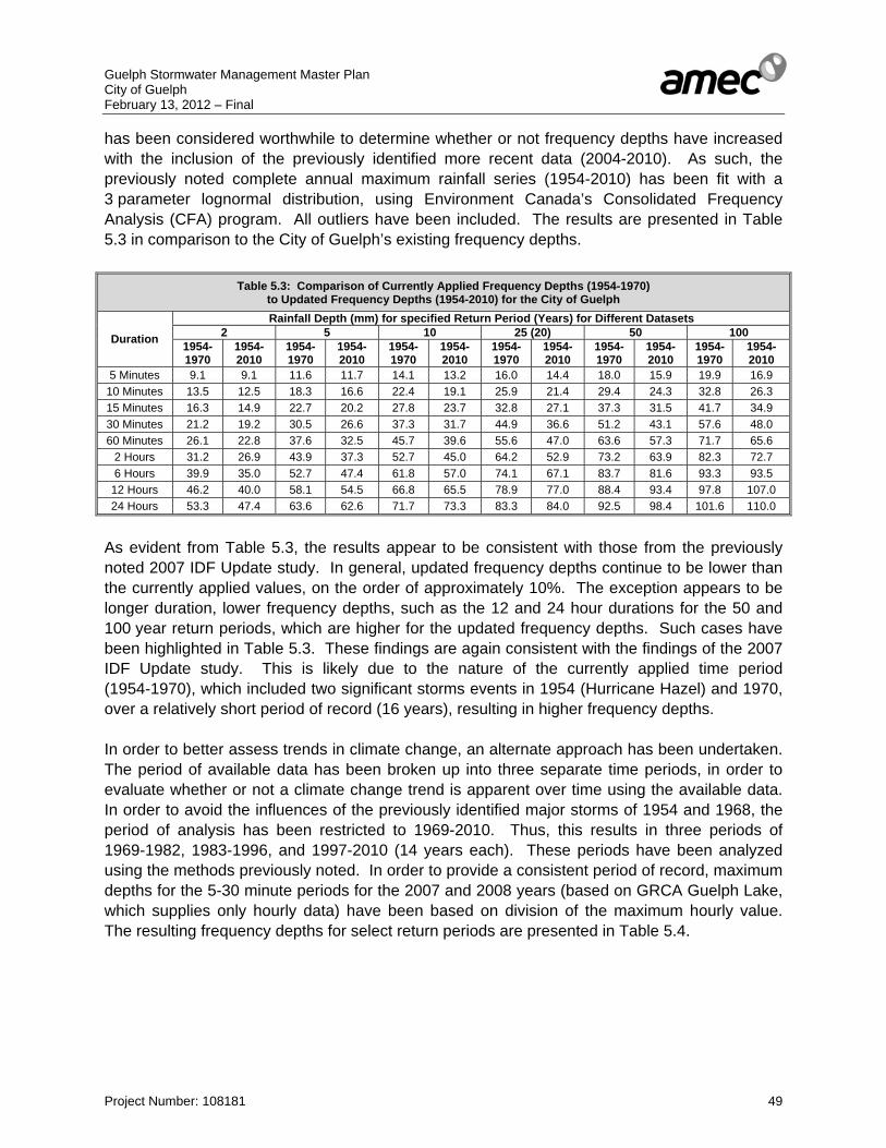
Guelph Stormwater Management Master Plan City of Guelph February 13, 2012 – Final
Project Number: 108181 49
has been considered worthwhile to determine whether or not frequency depths have increased with the inclusion of the previously identified more recent data (2004-2010). As such, the previously noted complete annual maximum rainfall series (1954-2010) has been fit with a 3 parameter lognormal distribution, using Environment Canada’s Consolidated Frequency Analysis (CFA) program. All outliers have been included. The results are presented in Table 5.3 in comparison to the City of Guelph’s existing frequency depths.
Table 5.3: Comparison of Currently Applied Frequency Depths (1954-1970) to Updated Frequency Depths (1954-2010) for the City of Guelph
Duration
Rainfall Depth (mm) for specified Return Period (Years) for Different Datasets 2 5 10 25 (20) 50 100
1954-1970
1954-2010
1954-1970
1954-2010
1954-1970
1954-2010
1954-1970
1954-2010
1954-1970
1954-2010
1954-1970
1954-2010
5 Minutes 9.1 9.1 11.6 11.7 14.1 13.2 16.0 14.4 18.0 15.9 19.9 16.9 10 Minutes 13.5 12.5 18.3 16.6 22.4 19.1 25.9 21.4 29.4 24.3 32.8 26.3 15 Minutes 16.3 14.9 22.7 20.2 27.8 23.7 32.8 27.1 37.3 31.5 41.7 34.9 30 Minutes 21.2 19.2 30.5 26.6 37.3 31.7 44.9 36.6 51.2 43.1 57.6 48.0 60 Minutes 26.1 22.8 37.6 32.5 45.7 39.6 55.6 47.0 63.6 57.3 71.7 65.6
2 Hours 31.2 26.9 43.9 37.3 52.7 45.0 64.2 52.9 73.2 63.9 82.3 72.7 6 Hours 39.9 35.0 52.7 47.4 61.8 57.0 74.1 67.1 83.7 81.6 93.3 93.5
12 Hours 46.2 40.0 58.1 54.5 66.8 65.5 78.9 77.0 88.4 93.4 97.8 107.0 24 Hours 53.3 47.4 63.6 62.6 71.7 73.3 83.3 84.0 92.5 98.4 101.6 110.0
As evident from Table 5.3, the results appear to be consistent with those from the previously noted 2007 IDF Update study. In general, updated frequency depths continue to be lower than the currently applied values, on the order of approximately 10%. The exception appears to be longer duration, lower frequency depths, such as the 12 and 24 hour durations for the 50 and 100 year return periods, which are higher for the updated frequency depths. Such cases have been highlighted in Table 5.3. These findings are again consistent with the findings of the 2007 IDF Update study. This is likely due to the nature of the currently applied time period (1954-1970), which included two significant storms events in 1954 (Hurricane Hazel) and 1970, over a relatively short period of record (16 years), resulting in higher frequency depths. In order to better assess trends in climate change, an alternate approach has been undertaken. The period of available data has been broken up into three separate time periods, in order to evaluate whether or not a climate change trend is apparent over time using the available data. In order to avoid the influences of the previously identified major storms of 1954 and 1968, the period of analysis has been restricted to 1969-2010. Thus, this results in three periods of 1969-1982, 1983-1996, and 1997-2010 (14 years each). These periods have been analyzed using the methods previously noted. In order to provide a consistent period of record, maximum depths for the 5-30 minute periods for the 2007 and 2008 years (based on GRCA Guelph Lake, which supplies only hourly data) have been based on division of the maximum hourly value. The resulting frequency depths for select return periods are presented in Table 5.4.
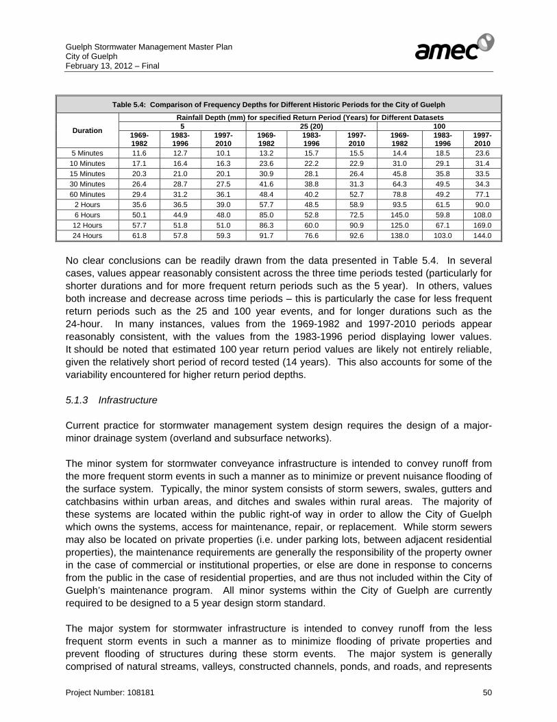
Guelph Stormwater Management Master Plan City of Guelph February 13, 2012 – Final
Project Number: 108181 50
Table 5.4: Comparison of Frequency Depths for Different Historic Periods for the City of Guelph
Duration
Rainfall Depth (mm) for specified Return Period (Years) for Different Datasets 5 25 (20) 100
1969-1982
1983-1996
1997- 2010
1969-1982
1983- 1996
1997- 2010
1969- 1982
1983- 1996
1997- 2010
5 Minutes 11.6 12.7 10.1 13.2 15.7 15.5 14.4 18.5 23.6 10 Minutes 17.1 16.4 16.3 23.6 22.2 22.9 31.0 29.1 31.4 15 Minutes 20.3 21.0 20.1 30.9 28.1 26.4 45.8 35.8 33.5 30 Minutes 26.4 28.7 27.5 41.6 38.8 31.3 64.3 49.5 34.3 60 Minutes 29.4 31.2 36.1 48.4 40.2 52.7 78.8 49.2 77.1
2 Hours 35.6 36.5 39.0 57.7 48.5 58.9 93.5 61.5 90.0 6 Hours 50.1 44.9 48.0 85.0 52.8 72.5 145.0 59.8 108.0
12 Hours 57.7 51.8 51.0 86.3 60.0 90.9 125.0 67.1 169.0 24 Hours 61.8 57.8 59.3 91.7 76.6 92.6 138.0 103.0 144.0
No clear conclusions can be readily drawn from the data presented in Table 5.4. In several cases, values appear reasonably consistent across the three time periods tested (particularly for shorter durations and for more frequent return periods such as the 5 year). In others, values both increase and decrease across time periods – this is particularly the case for less frequent return periods such as the 25 and 100 year events, and for longer durations such as the 24-hour. In many instances, values from the 1969-1982 and 1997-2010 periods appear reasonably consistent, with the values from the 1983-1996 period displaying lower values. It should be noted that estimated 100 year return period values are likely not entirely reliable, given the relatively short period of record tested (14 years). This also accounts for some of the variability encountered for higher return period depths. 5.1.3 Infrastructure Current practice for stormwater management system design requires the design of a major-minor drainage system (overland and subsurface networks). The minor system for stormwater conveyance infrastructure is intended to convey runoff from the more frequent storm events in such a manner as to minimize or prevent nuisance flooding of the surface system. Typically, the minor system consists of storm sewers, swales, gutters and catchbasins within urban areas, and ditches and swales within rural areas. The majority of these systems are located within the public right-of way in order to allow the City of Guelph which owns the systems, access for maintenance, repair, or replacement. While storm sewers may also be located on private properties (i.e. under parking lots, between adjacent residential properties), the maintenance requirements are generally the responsibility of the property owner in the case of commercial or institutional properties, or else are done in response to concerns from the public in the case of residential properties, and are thus not included within the City of Guelph’s maintenance program. All minor systems within the City of Guelph are currently required to be designed to a 5 year design storm standard. The major system for stormwater infrastructure is intended to convey runoff from the less frequent storm events in such a manner as to minimize flooding of private properties and prevent flooding of structures during these storm events. The major system is generally comprised of natural streams, valleys, constructed channels, ponds, and roads, and represents

Guelph Stormwater Management Master Plan City of Guelph February 13, 2012 – Final
Project Number: 108181 51
the routes of the storm runoff during events which exceed the capacity of the minor system (i.e. events above the 5 year standard). The major system is required to be designed in order to convey runoff from the Regulatory Storm event, which for Guelph is the greater of the 100 year or the Regional Storm (Hurricane Hazel); for urban drainage systems which serve relatively smaller drainage areas (i.e. roads which would convey flows for areas less than 50 ha) the 100 year standard is typically applied and for natural or constructed channels and valleys which convey runoff from relatively large drainage areas (i.e. greater than 100 ha), the Regional Storm standard is generally applied. Current practice for the design of the major system generally requires verification of the Regulatory Storm event which is to be applied. Much of the infrastructure within the City of Guelph, particularly within the City centre pre-dates the application of a major-minor drainage system, especially the need for positive overland flow routes. In some areas, the original infrastructure dates back over a century, and has been replaced or maintained as per the original size and geometry; in these instances, the criteria applied for the original design is unknown. In either instance, the stormwater infrastructure within the City of Guelph, while compliant with the prevailing standards and criteria of the day, would be considered sub-standard compared to the current standards which are applied for new designs. 5.2 Major/Minor System Modelling 5.2.1 Model Hydrologic and hydraulic analyses of the City’s major and minor system have been completed using PCSWMM software. The following objectives for the selection of the modelling platform have been used: 1. The platform should be a singular tool for assessing hydrology, minor and major system
hydraulics and stormwater quantity and quality facility functions. 2. The platform should have the flexibility to be used under event based and continuous
hydrologic modeling approaches. 3. The hydrologic continuous simulation should provide output to assess annual water
balance. 4. The platform should allow for the modeling of at source, conveyance and end-of-pipe
best stormwater management BMPs for both water quantity and quality assessment. The BMPs included or could be incorporated through platform customization should include those techniques considered to be part of Low Impact Development (LID).
5. The hydraulic model should allow for the assessment of variable hydraulic systems, such as creeks, storm systems and stormwater management infrastructure.
6. The platform should allow for easy import and export of stormwater management infrastructure data from and to typical database utilities and be compatible with GIS and AutoCADTM.
7. The platform should be easily upgradable and customizable to serve future City of Guelph stormwater management infrastructure design and assessment.
The PCSWMM software combines hydrologic modelling to generate storm runoff response (i.e. hydrographs) from land areas, with hydraulic modelling to evaluate water surface elevations

Guelph Stormwater Management Master Plan City of Guelph February 13, 2012 – Final
Project Number: 108181 52
and velocities within the conveyance system (i.e. sewers, road surfaces, open watercourses, culverts). The integration of hydrologic and hydraulic analyses allows PCSWMM to account for detention in ponding areas, backflow in pipes, surcharging of manholes, tailwater conditions (which may affect upstream storage and flow capacity within pipes), capacity at inlets to the sewer network (which would reduce the amount of runoff entering the sewer network and increase the amount of runoff conveyed overland during storm events), and depth of flooding of overland conveyance systems; these capabilities of the PCSWMM software make it particularly well-suited for analyzing urban drainage systems. The model applies both the Event Methodology for single storm events and continuous simulation of a long-term period or record of multiple storm events. For the Event Methodology synthetic design storms are typically used in order to evaluate flood frequency or risk. For continuous simulation rainfall records are required The model is capable of accounting for various conditions at outlets (i.e. open/unobstructed/free-flowing, partially/completely submerged to a constant depth, time-varying depth conditions, gated conditions). The hydraulic routing component within PCSWMM can be completed for unsteady state (i.e. time-varying flow) conditions using Kinematic Wave or Dynamic Wave routing techniques. The numerical stability of the PCSWMM platform allows for complex networks and systems to be readily modelled in the unsteady state condition, with little to no requirement for network simplification. PCSWMM employs the EPA-SWMM engine as its base, thus modeling files created in PCSWMM can be opened and executed within the EPA-SWMM program as well as PCSWMM. This also provides an additional degree of reliability and quality assurance to the modeling program. 5.2.2 Data The PCSWMM software requires the following input data for completing a coupled hydrologic and hydraulic analysis: • Areas and directly connected impervious coverages for the land segments contributing
to the conveyance system of interest. • Soils information (infiltration parameters) for the soils underlying the land segments,
including initial abstraction. • Surface slopes for the contributing drainage areas. • Land use characteristics for both the pervious and impervious components of the land
segments in order to establish the “roughness” of the surface. • Length, size, and inverts of the sewer network. • Material of the sewer network. • Manhole rim elevations • Typical cross-section and elevations of the surface drainage system (i.e. roads). • Locations of sewer inlets (catchbasins, ditch inlets) • Elevation and surface area relationships for surface storage zones (i.e. channels or
designated off-line storage areas).
Guelph Stormwater Management Master Plan City of Guelph February 13, 2012 – Final
Project Number: 108181 53
The previous data input for the City’s storm sewer network has been obtained based upon the following information provided by the City for the development of the models for the major-minor system: • GIS database of the City’s storm sewers and manholes (provided by the City of Guelph) • As-built drawings of stormwater infrastructure (provided by the City of Guelph) • Site servicing plans for key properties (provided by the City of Guelph) • Rooftop downspout connection mapping (provided by the City of Guelph) • Catchbasin mapping (provided by the City of Guelph) • Standard roadway cross-sections for different road classifications (provided by the City
of Guelph) • Various stormwater management reports (provided by the City of Guelph for City-
managed and privately owned and managed stormwater management facilities). • Land use plan for the City of Guelph (provided by the City of Guelph) • Property boundary and building envelope mapping (provided by the City of Guelph) • Soils mapping from the Ministry of Agriculture • Sites of historic flooding within the City of Guelph (provided by the City of Guelph) • Locations of publicly-owned properties within the City of Guelph (provided by the City of
Guelph) • 1 m contour data (provided by the City of Guelph) • Watercourse mapping (provided by the GRCA) • HEC-2 and HEC-RAS hydraulic models (provided by the GRCA) • Mapping of the roads within the City of Guelph (provided by the City of Guelph) A considerable effort has been spent to gather, assess, and gap fill missing data in order to ensure that the integrated model data is reasonable and correct. This has primarily consisted of obtaining correct storm sewer and manhole data. As an example, when the original City-wide manhole database provided by the City of Guelph was imported into PCSWMM, it was found that of the 6,700 manholes within the database, 1,900 (or approximately 30%) were missing rim elevation data, which is a key parameter to correctly model dual drainage pathways, as well as being required to differentiate between surcharging and flooding in the minor system analysis. Likewise, a large degree of incorrect or missing storm sewer data was encountered, primarily related to sewer inverts. In both cases, as-built drawings have been used extensively to verify and update erroneous information. Approximately 500 as-built drawings were obtained and reviewed for this purpose, primarily for gap filling and verification, as well as to update recent sewer works from the past several years that were not included in the original database supplied by the City of Guelph. The sewer database has been reviewed in order to identify and map the entire City’s trunk sewers to be modelled (i.e. generally sewers greater than 600 mm). Catchment boundaries for the City’s sewer network have been developed based upon the sewer locations and the contour, property boundary, and road data provided by the City. In certain instances, specific site servicing and grading plans have been requested in order to confirm drainage connections for key properties within the City. The majority of the developed Network boundaries have been provided to City staff for review, comment, and approval. Based on this process, a total of 59 sewershed networks have been identified for modeling (as shown in Drawing 11). Given the

Guelph Stormwater Management Master Plan City of Guelph February 13, 2012 – Final
Project Number: 108181 54
lack of smaller watercourses within older sections of the City (primarily areas north of the Speed River), many of the identified sewershed networks are substantial, with total contributing drainage areas of 200 ha and greater (the largest with a contributing drainage area of 418 ha). In order to facilitate drainage network identification, a standard naming convention has been applied. The first two letters of the drainage network refer to the watercourse to which it drains, with networks within each area then numbered sequentially. The identified drainage areas are as follows: • CC - Clythe Creek • ER - Eramosa River • HC - Hanlon Creek • HD - Hadati Creek • LS - Lower Speed River (below the confluence with the Eramosa River) • NW - Northwest Channel • US - Upper Speed River (upstream of the confluence with the Eramosa River) • WW - Willow West Channel Based on discussions with City of Guelph staff, certain areas of the City have not been considered for modeling purposes. Given the age of development within the south of the City of Guelph (generally less than 20 years, and in many cases, less than 10 years), it has not been considered worthwhile to re-assess these areas, as it has been assumed that these areas have been designed in accordance with current standards and are performing as intended. This approach appears to be confirmed by the relatively low number of observed instances of reported flooding in these areas (ref. Drawing 7). Likewise, given the difficulty in modeling and assessing areas with surface conveyance systems only (ditches, swales), both the Hanlon Business Park and Watson Parkway Industrial areas have not been modeled. 5.2.3 Analysis Approach A discussion of the various modeling parameters and techniques utilized for the previously identified sewershed network areas has been provided within this section of the report. General Approach • An event-based methodology has been applied, with the City of Guelph’s standard 5 and
100 year design storms (Chicago storms with variable durations of approximately 3 hours – a copy has been included in Appendix ‘E’) applied.
• A minor system only model has been applied for use in assessing minor system performance under the 5 year event, while a dual drainage model has been applied in order to assess the 100 year event.
Hydrologic Parameters • Subcatchment discretization has been based on the same methodology as outlined in
Section 5.2.2 for Network discretization. A highly resolute modeling approach has been
Guelph Stormwater Management Master Plan City of Guelph February 13, 2012 – Final
Project Number: 108181 55
applied, in order to be able to generate meaningful and accurate modeling results. In addition to modeling the identified trunk sewer (generally 600 mm or greater), the first section of each lateral sewer connecting in to the trunk has also been modeled. In addition to improving minor system modeling accuracy, this also allows for a greater degree of accuracy in dual drainage modeling, as discussed within this section. Subcatchment boundary plans have been included in Appendix ‘J’.
• Total and directly connected imperviousness (the value required by PCWMM) were calculated based on standard assumed values for different land uses. These starting values were then later adjusted as part of the calibration process, as detailed in Section 5.2.4.
• Imperviousness for residential land use segments was further adjusted from default values to account for the percentage of connected rooftop downspouts, as identified by mapping provided by the City of Guelph (a copy has been included in Appendix ‘C’). Detailed calculations have been included in Appendix ‘J’.
• Slopes and overland flow lengths have been calculated using available contour mapping, property boundaries, and aerial photography
• Manning’s roughness coefficients of 0.013 and 0.2 have been applied for impervious and pervious overland flow components respectively
• Depression storage depths of 1 and 5 mm have been applied for impervious and pervious catchment portions respectively
• The recommended default value of 25% has been applied for the zero depression storage imperviousness ratio (the portion of the impervious area with no depression storage)
• In order to facilitate usage of the modeling for continuous simulation, the Green-Ampt infiltration methodology has been applied. A literature review has been conducted to determine appropriate values for initial deficit, suction head, and hydraulic conductivity based on the soils found in the City of Guelph. This information has been provided in Appendix ‘J’.
• Hydraulic conductivity has been further adjusted to account for non-directly connected impervious land use segments (the difference between total and directly connected imperviousness).
Hydraulic Parameters • Hydraulic elements (storm sewers and manholes) have been imported directly into
PCSWMM from the City of Guelph’s database. As noted previously, the resulting data has then been screened for errors or missing data, with as-built drawings used principally to fill data gaps.
• A roughness value of 0.013 has been applied for concrete and PVC sewers, and a value of 0.024 has been applied for CSP sewers.
• Conduit exit losses have been applied to account for the hydraulic losses associated with sharp bends. Head loss coefficients from FHWA HEC-22 have been applied for this purpose.

Guelph Stormwater Management Master Plan City of Guelph February 13, 2012 – Final
Project Number: 108181 56
Stormwater Management Facilities • In general, end of pipe stormwater management facilities were not considered as part of
the modeling effort • Facilities that are located within a sewershed network (i.e. discharges back into the
storm sewer system) have necessarily been included in order to properly account for their impact
• Stage-surface area and stage-discharge relations for these facilities have been generated based on a review of available SWM Reports, surveyed data from the 2008 SWM Facility Inventory Report, and as-built drawings
Dual Drainage Model Creation • A generic 2-lane and 4-lane road section have been applied for major system modeling,
based on an assumed 4 m lane width, 2% cross-fall, 0.15 m curb height, and 2% right of way slope. These values appear to be generally consistent with roadway values found within the City of Guelph.
• Inlet capacity functions have been used to represent the connection between surface and sub-surface drainage (catchbasins). Based on the MTO’s Design Charts for Inlet Capacity (MTO Drainage Management Manual, 1997), a constant inlet capacity of 0.06 m3/s per catchbasin has been assumed. Accordingly, the total number of catchbasins per subcatchment have been calculated using the City’s database information (the resulting data has been included in Appendix ‘J’), which has then been multiplied by the assumed capacity to determine the maximum inlet capacity per subcatchment. A resulting simplified inlet capacity curve has then been applied to the model in order to connect the minor and major drainage systems at flow nodes.
Model Boundary Conditions - Open Drainage System Tailwater Analysis Storm sewers generally outlet either to a stormwater management facility, or else directly to a watercourse (creek or river). In the case where the storm sewer outlets to a watercourse, the resulting water level within the watercourse may have an impact on storm sewer performance (due to backwater effects). As such, consideration should be given to the resulting boundary conditions used for storm sewer outfalls within the generated PCSWMM models. In order to determine the boundary condition along a given stretch of watercourse, hydraulic models are required. HEC-2 models of the Speed River (Upper and Lower Reaches), Eramosa River, and Hadati Creek have been obtained from the GRCA. There are however a number of watercourses for which no hydraulic modeling is available, including the Hanlon Creek, Clythe Creek, and the Willow West Channel. In addition, there are a number of sewershed networks which outlet to small channels sufficiently upstream of watercourses, or others which outlet to stormwater management facilities. After accounting for these cases, only 23 of the total 59 modeled sewershed networks have available and applicable hydraulic modeling for each respective storm sewer outfall (less than 40%). A typically applied methodology is to use a free boundary condition under the 5 year storm event model. Due to the relative size of modeled sewershed networks as compared to

Guelph Stormwater Management Master Plan City of Guelph February 13, 2012 – Final
Project Number: 108181 57
upstream contributing areas for watercourses (particularly the Speed and Eramosa Rivers), the time to peak for the watercourse is considerably longer than for a sewershed network, which has a relatively quick hydrologic response. Accordingly, it is unlikely that there would be any substantial tailwater for a 5 year event. For a major storm (the 100 year event), there would however likely be some tailwater. As such, the 5 year level for the watercourse is typically applied as the boundary condition. However for a major event, such as the 100 year storm, overland flow dominates drainage patterns, and as such, the impact on overall water levels is likely minimal. Therefore, for the reasons noted, and in order to provide a consistent methodology, a free outfall boundary condition has been applied throughout for both the 5 year (Minor System) and 100 year (Major System) assessments. However, in order to confirm this approach, a sensitivity analysis has been conducted in order to confirm the significance of a fixed boundary condition on results. The sensitivity analysis has been based on assessing the impact of tailwater conditions on major system performance (100 year Storm Event, with 5 year tailwater level). A total of three separate sewershed networks with available hydraulic models, and outlets which are either partially or totally submerged under a 5 year water level, have been randomly selected: Network ER-01, LS-10, and US-03. Based on a comparison of maximum surface flooding depths at major system nodes, the results confirm the approach used of applying a free boundary condition for the 100 year simulation. Results have been found to be essentially identical for all three examined networks, with a maximum node elevation difference of 0.01 m. The vast majority of nodes showed no change between the two scenarios. These results confirm the applied approach of a free boundary condition for the remaining sewershed networks. 5.2.4 Model Calibration Hydrologic Model Calibration has been conducted using the continuous flow data and recorded rainfall data from the monitoring program, as detailed in Section 4.3 (and Appendix ‘J’). The calibration process was conducted for the previously identified seven networks for which monitoring data was collected (HD02, LS02, LS05, NW04, US03, US10, and WW06). The process was initiated with a sensitivity analysis to identify the most critical land use parameters, followed by the model calibration. The calibration was based around matching peak flows, as this result is the most critical in the assessment of drainage system performance. It is noted however that the correct estimation of runoff volumes is also important, particularly in sizing stormwater management facilities. Details of estimated runoff volumes have also been provided. A summary of the sensitivity analysis and calibration process and results are provided below. Detailed summaries have been attached in Appendix ‘J’, including a summary table, scatter plots, and sample hydrograph comparisons.
Guelph Stormwater Management Master Plan City of Guelph February 13, 2012 – Final
Project Number: 108181 58
• Sensitivity analysis showed directly connected imperviousness to be by far the most sensitive parameter. Most parameters were either completely insensitive or only slightly sensitive. Soil parameters (particularly hydraulic conductivity) were found to be reasonably sensitive only for larger storm events, which is logical given the relatively permeable soils found in the Guelph area. It was therefore determined that the calibration would be based around adjustment of directly connected imperviousness.
• For the calibration process, the original intention was to supplement the collected rainfall data with rainfall data from the GRCA to account for spatially variable storm events. However, the data from the GRCA was found to be of limited value – data was hourly only, and data from the Guelph Lake station was full of data flags stating that the data was questionable (manual daily total very different than summed hourly data from tipping bucket). It was therefore decided to use the GRCA data as a check only, to assess the spatial variability of the various storm events, and not to use it as part of the calibration runs. Radar rainfall data could likely be incorporated in the future to further enhance the calibration process.
• Similarly, several of the larger storm events could not be used for calibration for this reason (spatial variability). Very large difference in peak flows (simulated vs. observed) indicated that City Hall rain gauge was not an accurate source of rainfall data for these storms for several sewersheds. This means that soil parameters could not be accurately calibrated, furthering the calibration basis on directly connected imperviousness only. However, soil parameters have been based on a thorough literature review, and are considered to be sufficiently accurate for this assessment. Again, the incorporation of radar rainfall data in the future would likely assist in being able to apply these storm events.
• As noted, calibration has been conducted by adjusting directly connected imperviousness only (for residential land uses, directly connected imperviousness is a function of total imperviousness and the percentage of directly connected downspouts, based on the mapping supplied by the City of Guelph – ref Appendix ‘C’). In order to be able to apply the results of the calibration process to all sewersheds, the calibration has been done on an overall basis for the seven networks with available monitoring data. The adjustments have been made to the initially assumed impervious values for different land uses. The resulting overall changes are summarized in Table 5.5
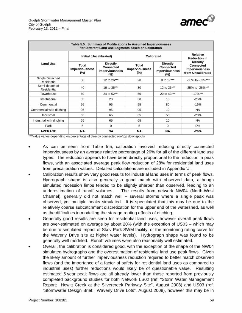
Guelph Stormwater Management Master Plan City of Guelph February 13, 2012 – Final
Project Number: 108181 59
Table 5.5: Summary of Modifications to Assumed Imperviousness
for Different Land Use Segments based on Calibration
Land Use
Initial (Uncalibrated) Calibrated Relative Reduction in
Directly Connected
Imperviousness from Uncalibrated
Total Imperviousness
(%)
Directly Connected
Imperviousness (%)
Total Imperviousness
(%)
Directly Connected
Imperviousness (%)
Single Detached Residential 30 12 to 26*** 20 8 to 17*** -33% to -53%***
Semi-detached Residential 40 16 to 35*** 30 12 to 26*** -25% to -26%***
Townhouse 60 24 to 52*** 50 20 to 43*** -17%***
Institutional 35 20 30 15 -25%
Commercial 95 95 95 80 -16%
Commercial with ditching 95 95 95 10 NA
Industrial 65 65 65 50 -23%
Industrial with ditching 65 65 65 10 NA
Park 5 0 5 0 0%
AVERAGE NA NA NA NA -26% ***Value varies depending on percentage of directly connected rooftop downspouts • As can be seen from Table 5.5, calibration involved reducing directly connected
imperviousness by an average relative percentage of 26% for all of the different land use types. The reduction appears to have been directly proportional to the reduction in peak flows, with an associated average peak flow reduction of 28% for residential land uses from precalibration values. Detailed calculations are included in Appendix ‘J’.
• Calibration results show very good results for industrial land uses in terms of peak flows. Hydrograph shape is also generally a good match with observed data, although simulated recession limbs tended to be slightly sharper than observed, leading to an underestimation of runoff volumes. The results from network NW04 (North-West Channel), generally did not match well – several storms where a single peak was observed, yet multiple peaks simulated. It is speculated that this may be due to the relatively coarse subcatchment discretization for the upper end of the watershed, as well as the difficulties in modelling the storage routing effects of ditching.
• Generally good results are seen for residential land uses, however overall peak flows are over-estimated on average by about 20% (with the exception of US03 – which may be due to simulated impact of Skov Park SWM facility, or the monitoring rating curve for the Waverly Drive site at higher water levels). Hydrograph shape was found to be generally well modeled. Runoff volumes were also reasonably well estimated.
• Overall, the calibration is considered good, with the exception of the shape of the NW04 simulated hydrographs and the overestimation of residential land use peak flows. Given the likely amount of further imperviousness reduction required to better match observed flows (and the importance of a factor of safety for residential land uses as compared to industrial uses) further reductions would likely be of questionable value. Resulting estimated 5 year peak flows are all already lower than those reported from previously completed background studies for both Network LS02 (ref. “Storm Water Management Report: Howitt Creek at the Silvercreek Parkway Site”, August 2008) and US03 (ref. “Stormwater Design Brief: Waverly Drive Lots”, August 2008), however this may be in
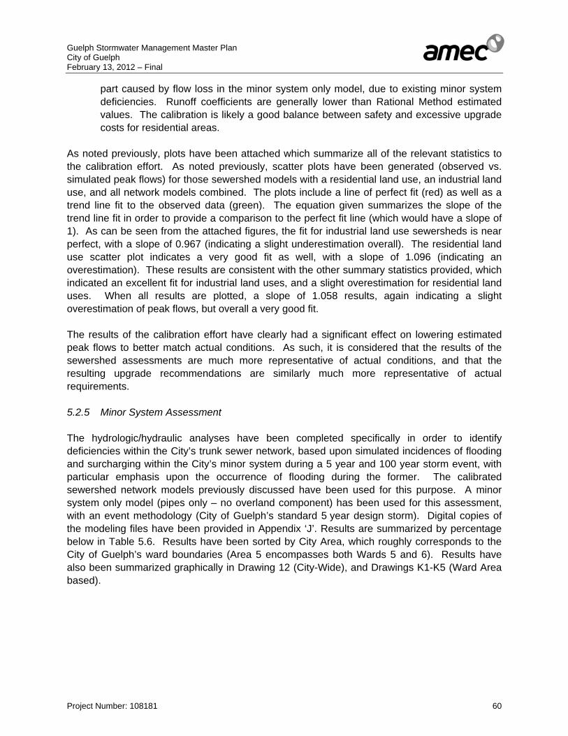
Guelph Stormwater Management Master Plan City of Guelph February 13, 2012 – Final
Project Number: 108181 60
part caused by flow loss in the minor system only model, due to existing minor system deficiencies. Runoff coefficients are generally lower than Rational Method estimated values. The calibration is likely a good balance between safety and excessive upgrade costs for residential areas.
As noted previously, plots have been attached which summarize all of the relevant statistics to the calibration effort. As noted previously, scatter plots have been generated (observed vs. simulated peak flows) for those sewershed models with a residential land use, an industrial land use, and all network models combined. The plots include a line of perfect fit (red) as well as a trend line fit to the observed data (green). The equation given summarizes the slope of the trend line fit in order to provide a comparison to the perfect fit line (which would have a slope of 1). As can be seen from the attached figures, the fit for industrial land use sewersheds is near perfect, with a slope of 0.967 (indicating a slight underestimation overall). The residential land use scatter plot indicates a very good fit as well, with a slope of 1.096 (indicating an overestimation). These results are consistent with the other summary statistics provided, which indicated an excellent fit for industrial land uses, and a slight overestimation for residential land uses. When all results are plotted, a slope of 1.058 results, again indicating a slight overestimation of peak flows, but overall a very good fit. The results of the calibration effort have clearly had a significant effect on lowering estimated peak flows to better match actual conditions. As such, it is considered that the results of the sewershed assessments are much more representative of actual conditions, and that the resulting upgrade recommendations are similarly much more representative of actual requirements. 5.2.5 Minor System Assessment The hydrologic/hydraulic analyses have been completed specifically in order to identify deficiencies within the City’s trunk sewer network, based upon simulated incidences of flooding and surcharging within the City’s minor system during a 5 year and 100 year storm event, with particular emphasis upon the occurrence of flooding during the former. The calibrated sewershed network models previously discussed have been used for this purpose. A minor system only model (pipes only – no overland component) has been used for this assessment, with an event methodology (City of Guelph’s standard 5 year design storm). Digital copies of the modeling files have been provided in Appendix ‘J’. Results are summarized by percentage below in Table 5.6. Results have been sorted by City Area, which roughly corresponds to the City of Guelph’s ward boundaries (Area 5 encompasses both Wards 5 and 6). Results have also been summarized graphically in Drawing 12 (City-Wide), and Drawings K1-K5 (Ward Area based).
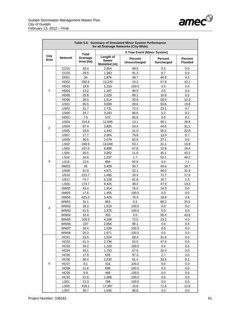
Guelph Stormwater Management Master Plan City of Guelph February 13, 2012 – Final
Project Number: 108181 61
Table 5.6: Summary of Simulated Minor System Performance
for all Drainage Networks (City-Wide)
City Area Network
Total Drainage Area (ha)
5 Year Event (Minor System) Length of
Sewer Modelled (m)
Percent Unsurcharged
Percent Surcharged
Percent Flooded
1
CC01 53.4 2,854 99.5 0.5 0.0 CC02 28.5 1,383 91.3 8.7 0.0 ER01 34 1,876 48.7 46.9 4.5 HD02 282.6 13,220 10.2 57.8 32.1 HD03 19.9 1,233 100.0 0.0 0.0 HD04 13.2 1,187 96.5 3.5 0.0 HD05 25.8 2,029 89.1 10.9 0.0 HD06 36.5 1,514 30.8 58.9 10.3 US01 65.5 3,699 29.6 50.6 19.8 US02 31.7 2.731 72.2 23.1 4.7 US06 34.7 3,243 86.6 5.2 8.2
2
HD01 7.5 572 85.8 5.9 8.2 US03 214.8 12,695 13.1 58.1 28.8 US04 67.4 3,820 24.4 44.5 31.1 US05 23.9 1,442 21.0 56.2 22.8 US07 17.7 2,004 79.8 13.4 6.7 US09 30.5 2,079 62.9 37.1 0.0
3
LS02 240.9 13,049 53.1 31.1 15.8 LS03 157.6 8,898 67.8 12.8 19.4 LS04 35.5 3,002 11.6 45.1 43.2 LS14 16.6 1,237 1.7 52.1 46.2 LS15 13.5 884 92.9 0.0 7.1 NW01 45 3,409 30.7 49.6 19.7 US08 61.6 4,471 22.1 46.0 31.9 US10 213.7 1,495 10.4 71.7 17.9 US11 74.7 5,128 81.8 16.7 1.5
4
LS06 173.7 9,425 39.2 47.5 13.3 NW02 43.4 1,914 76.0 24.0 0.0 NW03 17.6 1,455 100.0 0.0 0.0 NW04 623.2 3,426 75.3 19.8 4.9 WW01 31.1 963 6.2 68.2 25.5 WW02 18.3 1,519 100.0 0.0 0.0 WW03 41.5 2,375 100.0 0.0 0.0 WW04 10.4 303 0.0 56.4 43.6 WW05 109.5 4,108 72.5 23.2 4.3 WW06 237 2,856 99.1 0.0 0.9 WW07 16.4 1,539 100.0 0.0 0.0 WW08 20.3 1,671 100.0 0.0 0.0
5
HC01 23.5 1,024 68.4 31.6 0.0 HC02 51.3 2,736 52.5 47.5 0.0 HC03 34.2 1,103 100.0 0.0 0.0 HC04 45.1 1,753 67.6 32.4 0.0 HC05 17.9 635 97.3 2.7 0.0 HC06 36.4 2,030 61.4 33.5 5.1 HC07 8.1 416 100.0 0.0 0.0 HC08 11.6 699 100.0 0.0 0.0 HC09 9.8 466 100.0 0.0 0.0 HC10 21.6 1,368 100.0 0.0 0.0 LS01 12.3 798 100.0 0.0 0.0 LS05 418.1 17,997 15.8 71.6 12.6 LS07 30.7 1,545 96.8 3.2 0.0
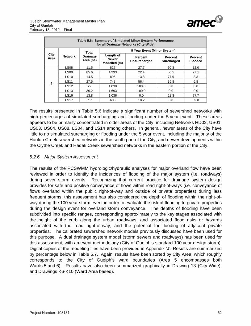
Guelph Stormwater Management Master Plan City of Guelph February 13, 2012 – Final
Project Number: 108181 62
Table 5.6: Summary of Simulated Minor System Performance for all Drainage Networks (City-Wide)
City Area Network
Total Drainage Area (ha)
5 Year Event (Minor System) Length of
Sewer Modelled (m)
Percent Unsurcharged
Percent Surcharged
Percent Flooded
5
LS08 11.5 827 27.7 60.3 12.0 LS09 85.6 4,993 22.4 50.5 27.1 LS10 14.5 896 13.8 77.9 8.3 LS11 27.5 748 56.4 36.8 6.8 LS12 22 1,038 100.0 0.0 0.0 LS13 30.2 1,693 100.0 0.0 0.0 LS16 13.8 1,036 0.0 22.3 77.7 LS17 7.7 608 10.2 0.0 89.8
The results presented in Table 5.6 indicate a significant number of sewershed networks with high percentages of simulated surcharging and flooding under the 5 year event. These areas appears to be primarily concentrated in older areas of the City, including Networks HD02, US01, US03, US04, US08, LS04, and LS14 among others. In general, newer areas of the City have little to no simulated surcharging or flooding under the 5 year event, including the majority of the Hanlon Creek sewershed networks in the south part of the City, and newer developments within the Clythe Creek and Hadati Creek sewershed networks in the eastern portion of the City. 5.2.6 Major System Assessment The results of the PCSWMM hydrologic/hydraulic analyses for major overland flow have been reviewed in order to identify the incidences of flooding of the major system (i.e. roadways) during sever storm events. Recognizing that current practice for drainage system design provides for safe and positive conveyance of flows within road right-of-ways (i.e. conveyance of flows overland within the public right-of-way and outside of private properties) during less frequent storms, this assessment has also considered the depth of flooding within the right-of-way during the 100 year storm event in order to evaluate the risk of flooding to private properties during the design event for overland storm conveyance. The depths of flooding have been subdivided into specific ranges, corresponding approximately to the key stages associated with the height of the curb along the urban roadways, and associated flood risks or hazards associated with the road right-of-way, and the potential for flooding of adjacent private properties. The calibrated sewershed network models previously discussed have been used for this purpose. A dual drainage system model (storm sewers and roadways) has been used for this assessment, with an event methodology (City of Guelph’s standard 100 year design storm). Digital copies of the modeling files have been provided in Appendix ‘J’. Results are summarized by percentage below in Table 5.7. Again, results have been sorted by City Area, which roughly corresponds to the City of Guelph’s ward boundaries (Area 5 encompasses both Wards 5 and 6). Results have also been summarized graphically in Drawing 13 (City-Wide), and Drawings K6-K10 (Ward Area based).

Guelph Stormwater Management Master Plan City of Guelph February 13, 2012 – Final
Project Number: 108181 63
Table 5.7: Summary of Simulated Major System Performance
for all Drainage Networks (City-Wide)
City Area Network
Total Drainage Area (ha)
100 Year Event (Major System) Length of
Roadway Modelled (m)
Percent < 0.15 m
Percent 0.15 – 0.25 m
Percent > 0.25 m
1
CC01 53.4 2,749 56.2 43.8 0.0 CC02 28.5 1,405 84.3 0.0 15.7 ER01 34 2,334 44.5 27.4 28.1 HD02 282.6 11,171 46.3 44.1 9.6 HD03 19.9 865 86.0 3.4 10.6 HD04 13.2 1,081 88.6 2.2 9.2 HD05 25.8 2,282 86.8 2.9 10.3 HD06 36.5 1,607 63.6 16.1 20.3 US01 65.5 3,175 55.7 27.7 16.6 US02 31.7 2,437 68.0 7.4 24.6 US06 34.7 2,998 86.6 0.0 13.4
2
HD01 7.5 503 82.7 17.3 0.0 US03 214.8 12,134 45.0 48.7 6.3 US04 67.4 3,263 29.4 39.9 30.7 US05 23.9 1,513 68.1 4.6 27.4 US07 17.7 1,913 100.0 0.0 0.0 US09 30.5 948 77.7 12.9 9.4
3
LS02 240.9 10,525 55.4 33.7 10.9 LS03 157.6 8,017 63.3 29.9 6.8 LS04 35.5 2,889 66.0 24.6 9.4 LS14 16.6 1,220 44.8 28.9 26.3 LS15 13.5 1,109 100.0 0.0 0.0 NW01 45 3,152 84.0 15.0 1.0 US08 61.6 3,246 67.6 10.5 21.9 US10 213.7 1,471 84.6 7.3 8.1 US11 74.7 3,757 45.0 14.3 40.7
4
LS06 173.7 9,720 49.5 37.1 13.4 NW02 43.4 2,010 57.3 8.9 33.9 NW03 17.6 1,288 88.2 2.4 9.4 NW04 623.2 1,567 80.7 19.3 0.0 WW01 31.1 919 11.4 68.0 20.6 WW02 18.3 1,658 83.8 16.2 0.0 WW03 41.5 2,436 73.4 9.0 17.6 WW04 10.4 255 0.0 16.9 83.1 WW05 109.5 3,671 33.0 37.4 29.6 WW06 237 916 5.5 59.9 34.6 WW07 16.4 1,644 100.0 0.0 0.0 WW08 20.3 1,624 94.9 0.0 5.1
5
HC01 23.5 846 62.6 8.9 28.5 HC02 51.3 2,686 67.1 3.0 29.9 HC03 34.2 645 50.7 35.8 13.5 HC04 45.1 1,561 50.7 28.9 20.4 HC05 17.9 830 28.9 52.5 18.6 HC06 36.4 2,046 53.3 37.5 9.1 HC07 8.1 334 100.0 0.0 0.0 HC08 11.6 567 97.0 3.0 0.0 HC09 9.8 466 65.0 0.0 35.0 HC10 21.6 1,304 48.7 46.2 5.1 LS01 12.3 770 91.8 0.0 8.2 LS05 418.1 16,232 58.3 36.8 4.9 LS07 30.7 240 100.0 0.0 0.0
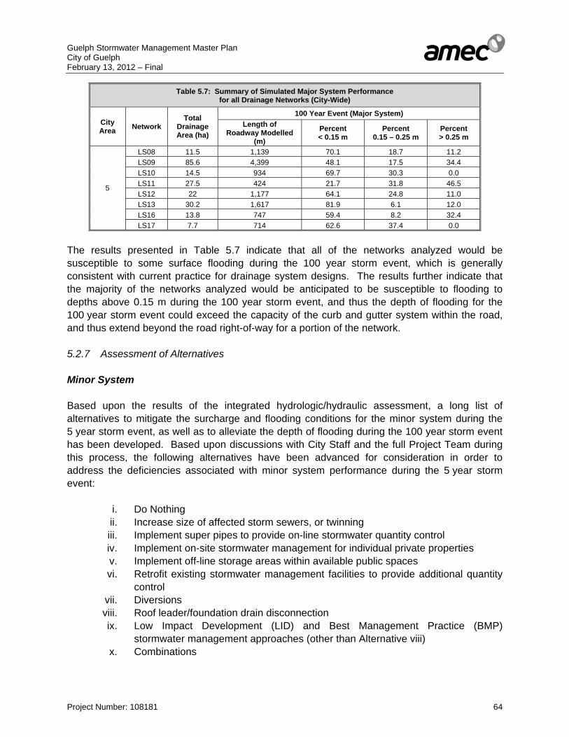
Guelph Stormwater Management Master Plan City of Guelph February 13, 2012 – Final
Project Number: 108181 64
Table 5.7: Summary of Simulated Major System Performance for all Drainage Networks (City-Wide)
City Area Network
Total Drainage Area (ha)
100 Year Event (Major System) Length of
Roadway Modelled (m)
Percent < 0.15 m
Percent 0.15 – 0.25 m
Percent > 0.25 m
5
LS08 11.5 1,139 70.1 18.7 11.2 LS09 85.6 4,399 48.1 17.5 34.4 LS10 14.5 934 69.7 30.3 0.0 LS11 27.5 424 21.7 31.8 46.5 LS12 22 1,177 64.1 24.8 11.0 LS13 30.2 1,617 81.9 6.1 12.0 LS16 13.8 747 59.4 8.2 32.4 LS17 7.7 714 62.6 37.4 0.0
The results presented in Table 5.7 indicate that all of the networks analyzed would be susceptible to some surface flooding during the 100 year storm event, which is generally consistent with current practice for drainage system designs. The results further indicate that the majority of the networks analyzed would be anticipated to be susceptible to flooding to depths above 0.15 m during the 100 year storm event, and thus the depth of flooding for the 100 year storm event could exceed the capacity of the curb and gutter system within the road, and thus extend beyond the road right-of-way for a portion of the network. 5.2.7 Assessment of Alternatives Minor System Based upon the results of the integrated hydrologic/hydraulic assessment, a long list of alternatives to mitigate the surcharge and flooding conditions for the minor system during the 5 year storm event, as well as to alleviate the depth of flooding during the 100 year storm event has been developed. Based upon discussions with City Staff and the full Project Team during this process, the following alternatives have been advanced for consideration in order to address the deficiencies associated with minor system performance during the 5 year storm event:
i. Do Nothing ii. Increase size of affected storm sewers, or twinning iii. Implement super pipes to provide on-line stormwater quantity control iv. Implement on-site stormwater management for individual private properties v. Implement off-line storage areas within available public spaces vi. Retrofit existing stormwater management facilities to provide additional quantity
control vii. Diversions viii. Roof leader/foundation drain disconnection ix. Low Impact Development (LID) and Best Management Practice (BMP)
stormwater management approaches (other than Alternative viii) x. Combinations

Guelph Stormwater Management Master Plan City of Guelph February 13, 2012 – Final
Project Number: 108181 65
The following alternatives have been initially screened out for further consideration: Alternative i. (Do Nothing) does not address the issues associated with deficient
infrastructure capacity and flooding and has therefore been screened from further consideration.
Alternative iii. (Super-Pipes) are generally not a cost-effective option, and provide a minimal flood control benefit. They are also dependant on having a sufficient grade difference (to avoid backwater effects) and sufficient space within City-owned land. Given these difficulties, this option has been screened from further consideration.
Alternative iv. (On-site SWM) would necessitate participation from private landowners (which may not be obtained) and would not give the City control over the system. This option has therefore been screened from further consideration.
Alternative vi. (Retrofit existing SWM facilities) is generally not considered to be a viable option, as the majority of existing SWM facilities have likely already been maximized. This option has therefore been screened from future consideration.
Accordingly, the short-listed possibilities for alleviating minor system flooding are: • Alternative ii. (Increase size of affected storm sewers, or twinning) is typically the most
effective alternative – possible issues with cost and existing utility locations, ground cover should be considered however.
• Alternative v. (Implement off-line storage areas within available public spaces) is possible, however limited space available, and a possible reduction in public use area (unless underground storage used which is significantly more expensive). This alternative can be an effective option in appropriate locations however.
• Alternative vii. (Diversions) is possible, and can be an effective option in reducing the number of storm sewers on private property in certain locations (as shown in Drawing 8). However, this alternative assumes that there is a system which sufficient extra capacity to accept the additional flow, and that a diversion is possible given existing grades.
• Alternative viii. (Roof leader/foundation drain disconnection). There is no readily available data on foundation drains, but roof leader disconnection mapping has been provided by the City of Guelph – possible solution in areas where majority of residences are directly connected into the storm sewer system.
• Alternative ix. (LID and BMP measures) can be an effective approach in retrofit and reconstruction areas. However, their applicability can be constrained by site-specific limitations such as available space, grading constraints, utilities, etc.).
• Alternative x. (Combinations) is likely an appropriate solution where no single alternative is sufficient to address issues.
Based on the foregoing short-list of alternatives, a drainage system upgrade analysis has been conducted in order to determine the requirements to mitigate surcharge and flooding under the 5 year event. The majority of applied upgrades have consisted of storm sewer upgrades (Alternative ii) as it is generally considered to be the simplest and in many cases most effective solution. Upgrades have also been considered in conjunction with local storm sewer diversions (Alternative vii) where appropriate. Off-line storage areas (Alternative v) have also been recommended in areas where available public land exists, and where it would be a more cost-effective solution. Roof leader downspout disconnection (Alternative viii) has also been
Guelph Stormwater Management Master Plan City of Guelph February 13, 2012 – Final
Project Number: 108181 66
considered for areas with significant surcharging and flooding issues where available mapping has indicated that a high percentage of residences are directly connected. Although not evaluated directly as part of this upgrade analysis (for the reasons noted previously), LID and related BMPs (Alternative ix) should be encouraged and promoted wherever possible, particularly in areas noted in the City with identified capacity issues, such as those where downspout disconnection has been recommended. LID and related BMPs would have to be assessed on an individual site basis for each of these areas to determine their appropriateness. The BMP/LID toolkit within EPA-SWMM (and thus PCSWMM) provides an excellent method to quantify BMP/LID feasibility and performance when potential sites are identified. A more detailed discussion of LID application and potential priority neighbourhood areas for implementation has been provided in Section 5.5. Costing Costs for storm sewer upgrades have been estimated using the same approach as has been applied in previous studies and other budget estimates conducted for the City of Guelph. Namely, costs have been estimated as three (3) times the required pipe supply cost (based on a 2010 pricelist for 65-D concrete pipe) in order to account for installation, replacement appurtenances (i.e. catchbasins and manholes), and resurfacing of the roads. It should be noted that the costs listed apply only to the sewers modeled – any upgrade project would likely involve the upgrade of smaller connected storm sewers as well. Detailed calculations are provided in Table M1 (Appendix ‘M’). Costs for surface SWM facilities have been estimated based on $60 per cubic metre of storage required for the 5 year storm event (based on typically applied costing methods). More detailed cost estimates have been generated for prioritized (short-term implementation) SWM facilities. For the one recommended underground storage facility, costs have been estimated based on $360 per cubic metre of underground storage required for the 5 year event (based on previous experience with construction of underground storage tanks). For the downspout disconnection program, a cost of $100 per home has been assumed. This assumes that the homeowner does the work, and that the $100 is offered as a subsidy by the City once the work is complete. This is consistent with estimates from the City of Toronto for homeowner based work. The City of Toronto data suggests that costs are substantially higher if City forces do the work, approximately $1,000 per home. Number of affected houses has been calculated by identifying those subcatchments for which downspouts have been identified as connected, then assuming a density of 10 houses per ha. This cost estimate does not include the cost of any associated educational program or any associated administrative costs or associated programs (such as a potential rain barrel program). Cost estimate details for the downspout disconnection program have been included in Table M2 (Appendix ‘M’). Detailed costing estimates and the corresponding list of storm sewers to be upgraded have been included in Appendix ‘O’. Results for those networks that require upgrades are presented in Table 5.8. Results are presented graphically in Drawing 14, and Drawings K10-K15 (Appendix ‘K’). Additional notes for specific drainage network upgrades are summarized in Table K1 (Appendix ‘K’).
Guelph Stormwater Management Master Plan City of Guelph February 13, 2012 – Final
Project Number: 108181 67
SWM Facilities (Quantity Control/Off-Line Storage) A total of five (5) new SWM facilities (for quantity or flood control) have been proposed as part of the previously noted drainage system upgrade analysis. These facilities have been proposed in locations where there is available public space, and where flow reduction would be considered a more effective solution than extensive storm sewer upgrades. Of these five facilities, one has been proposed as an underground facility given space limitations (Oak Park – Network LS05), while the other four have been initially considered as surface facilities. Two of the five proposed new SWM facilities have been identified as priority items for short-term implementation, as detailed in Table 5.17. As such, a higher level of detail has been established for these facilities. Preliminary concept drawings have been provided in Appendix ‘L’. Drawing L12 illustrates the preliminary concept design for the proposed Green Meadows Facility (within Green Meadows Park off of Stevenson Street in network HD02), while Drawing L13 illustrates the preliminary concept design for the proposed Waverly Drive Facility (within Windsor Park, off of Waverly Drive in network US03). The Green Meadows Facility is considered a key component of the upgrade strategy for Network HD02. It is the only significant parcel of publicly owned land within the sewershed along the path of the main trunk sewer. In order to avoid having to upgrade a extensive length of existing trunk sewer (approximately 650 m of existing 1650 mm diameter sewer) between Green Meadows Park and Grange Street, a large portion of which is located within private property (which would therefore be difficult or impossible to upgrade), peak flows would need to be attenuated by an new facility. In addition, without upstream flow attenuation, further upgrades (beyond those indicated in Table 5.8) would be required downstream of Grange Street, which would also do nothing to limit flows to flood-prone areas downstream. As such, the implementation of a quantity control facility in Green Meadows Park is considered fundamental to the upgrade strategy within Network HD02. The preliminary concept design is presented in Drawing L12. The design involves placing a restrictor within the storm sewer system along Stevenson Street, with an overflow to direct higher flows towards the proposed surface facility. Controlled outflow from the facility would then combine with flow through the restrictor into the existing trunk sewer downstream along Stevenson Street. Shallow storm sewer grades along Stevenson Street complicate the design, which causes the need for the restrictor, as well as a height offset for the inlet pipe. This allows for sufficient grade through the facility, and also ensures that flow within the trunk sewer on Stevenson Street does not backflow into the proposed facility via the facility’s outlet pipe. The concept for the surface water storage area has been based on realistic grading, and incorporating buffers from adjacent properties and the proposed relocated playground area and a vehicle access route/trailway, while providing sufficient storage to attenuate the 5 year event at depths below MOE recommended values. The potential also exists to use portions of the remaining areas of the park for storage under more formative storm events (such as the 100 year event), however this would need to be assessed further. The Waverly Drive facility is also considered a key element of the upgrade strategy for Network US03. As with the Green Meadows facility, it is the only significant parcel of publicly owned land along the path of the main trunk sewer. Unlike the Green Meadows Facility, there is
Guelph Stormwater Management Master Plan City of Guelph February 13, 2012 – Final
Project Number: 108181 68
insufficient available storage volume to fully eliminate the need for storm sewer upgrades downstream; however, the facility would minimize the amount required thereby potentially optimizing overall system performance. The preliminary concept design is presented in Drawing L13. The design involves maintaining the existing storm sewer through Windsor Park as a low-flow bypass, in order to maximize available storage during flood conditions. Controlled outflow from the facility then would combine with flow from the bypass into the existing open channel. The limited available area, and the narrow geometry of the property, limits the amount of storage available from the facility, particularly when realistic side slopes, the need for a maintenance access, and the need to control depths below MOE recommended values are considered. An armourstone retaining wall would likely be required along a portion of the north property line to overcome the relatively steep grade difference in this location. The current conceptual design incorporates a single cell design only, with the portion of land fronting on Waverly Drive to be used as a relocated park and playground, and the existing open channel area unchanged. However, as noted in Drawing L13, the City holds an easement over an additional piece of land to the north of the open channel (within the current Guelph Golf and Country Club) which should be explored as potential additional storage. In both cases, it is noted that a separate Environmental Assessment (EA) process (Schedule B) should be conducted prior to implementation. Given that both proposed facilities are located within public parks, and adjacent to residential properties, public input would be highly important and necessary in ensuring that any facility design adequately addresses all concerns. In addition, consultation with the City of Guelph’s Park Planning & Development Group is of key importance, in order to balance stormwater management requirements with any potential loss of recreational area, and in order to ensure compatibility agreement with the City of Guelph’s Trail Master Plan, and any Park Master Plans, if they exist. Opportunities for naturalization and enhanced trail routes should be explored in any retrofit. Likewise, opportunities for bi-level stormwater management facilities should be considered in this regard (i.e. underground storage for minor events, storm surface storage for major storm events). More detailed cost estimates have been generated for the two priority facilities cited, as provided in Appendix ‘L’ (Tables L12 and L13). These cost estimates have been based upon the initial concept designs. As noted previously, costs for non-priority surface SWM facilities have been based on a more simplified estimate of $60 per cubic metre of storage for the 5 year event, with costs for the underground facility significantly higher, at $360 per cubic metre. Two SWM facilities (quantity control) are shown in Drawing 14 (and Drawing K10-K15) however are not presented in Table 5.8: the Ward 1 SWM Facility (Network HD02) and the Silvercreek facility (Network LS02). Both are priority facilities, as per Table 5.17. Both are end-of-pipe facilities, and have not been analyzed for storage requirements, as the flow targets would be based on a further downstream analysis (and due to the fact that both have been the subject of previous studies). In the case of the Ward 1 SWM facility, the Ward 1 Class EA (September 2007) originally proposed the facility as a quality only facility (no quantity control). However, simulated flows generated from the calibrated PCSWMM models developed as part of this study are significantly higher than those in the original Class EA report. As such, in order to avoid increasing infrastructure sizing downstream, it is recommended that a quantity control function be considered for incorporation into this facility. As no flow target or storage requirement has
Guelph Stormwater Management Master Plan City of Guelph February 13, 2012 – Final
Project Number: 108181 69
yet been determined, costing for this facility is based on the value given in the Ward 1 EA (2008), and does not include land costs. The second facility, within the Lafarge/CNR lands was most recently documented in “Storm Water Management Report: Howitt Creek at the Silvercreek Parkway Site”, August 2008. A quantity control facility is proposed at this location in order to control flows to the capacity of the Waterloo Avenue culvert downstream. Again, since downstream flow targets would be based on a further analysis, no absolute storage requirements have been calculated. The cost estimate for this facility is based on the value calculated as part of the aforementioned study. However, it should be noted that the 5 year flow estimated using the calibrated PCSWMM modeling is somewhat higher than that estimated in the originally cited report. As such, storage requirements will likely be more substantial than those stated in the report. The results for those networks that require upgrades are presented in Table 5.8. In addition to the foregoing formal quantity control facilities, a flow rate target has been proposed as part of the drainage system upgrade strategy for Network LS05. In order to avoid costly upgrades to the large trunk sewer along College Street and further downstream, it has been proposed to limit the 5 year discharge from the 1800 mm storm sewer from the University of Guelph lands to approximately 5 m3/s (from a current simulated peak discharge of approximately 8 m3/s). The flow restriction of 5 m3/s has been selected to eliminate surcharging for most of the receiving storm sewer system. There is potential for optimization of the flow restriction based on discussion with City staff and the level of service the storm sewer system will provide. Because no detailed information on the SWM strategy for these private lands was readily available, it is possible that this flow target is already being achieved, as the parameterization for these lands within the modeling has been based on an assumption of no SWM control (with the exception of two properties for which superpipe storage was evident based on sewer mapping provided by the University of Guelph, or for which information was provided by the City of Guelph). However, the details of any existing SWM control should be confirmed. Discussions with the University of Guelph would be required in order to assess current conditions and determine whether or not the proposed flow target is achievable (or is already being achieved). As noted, the alternative would be significant drainage system upgrades, or targeted quantity control storage elsewhere in the drainage network.
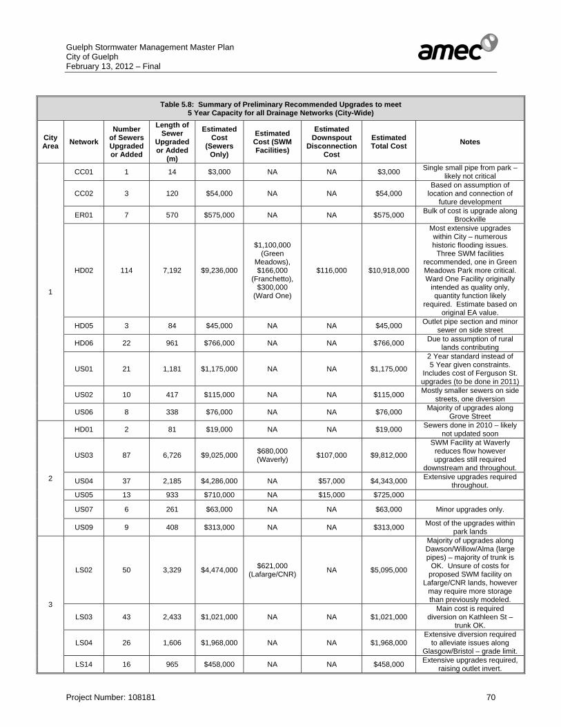
Guelph Stormwater Management Master Plan City of Guelph February 13, 2012 – Final
Project Number: 108181 70
Table 5.8: Summary of Preliminary Recommended Upgrades to meet
5 Year Capacity for all Drainage Networks (City-Wide)
City Area Network
Number of Sewers Upgraded or Added
Length of Sewer
Upgraded or Added
(m)
Estimated Cost
(Sewers Only)
Estimated Cost (SWM Facilities)
Estimated Downspout
Disconnection Cost
Estimated Total Cost Notes
1
CC01 1 14 $3,000 NA NA $3,000 Single small pipe from park – likely not critical
CC02 3 120 $54,000 NA NA $54,000 Based on assumption of
location and connection of future development
ER01 7 570 $575,000 NA NA $575,000 Bulk of cost is upgrade along Brockville
HD02 114 7,192 $9,236,000
$1,100,000 (Green
Meadows), $166,000
(Franchetto), $300,000
(Ward One)
$116,000 $10,918,000
Most extensive upgrades within City – numerous historic flooding issues.
Three SWM facilities recommended, one in Green Meadows Park more critical. Ward One Facility originally
intended as quality only, quantity function likely
required. Estimate based on original EA value.
HD05 3 84 $45,000 NA NA $45,000 Outlet pipe section and minor sewer on side street
HD06 22 961 $766,000 NA NA $766,000 Due to assumption of rural lands contributing
US01 21 1,181 $1,175,000 NA NA $1,175,000
2 Year standard instead of 5 Year given constraints.
Includes cost of Ferguson St. upgrades (to be done in 2011)
US02 10 417 $115,000 NA NA $115,000 Mostly smaller sewers on side streets, one diversion
US06 8 338 $76,000 NA NA $76,000 Majority of upgrades along Grove Street
2
HD01 2 81 $19,000 NA NA $19,000 Sewers done in 2010 – likely not updated soon
US03 87 6,726 $9,025,000 $680,000 (Waverly) $107,000 $9,812,000
SWM Facility at Waverly reduces flow however upgrades still required
downstream and throughout.
US04 37 2,185 $4,286,000 NA $57,000 $4,343,000 Extensive upgrades required throughout.
US05 13 933 $710,000 NA $15,000 $725,000
US07 6 261 $63,000 NA NA $63,000 Minor upgrades only.
US09 9 408 $313,000 NA NA $313,000 Most of the upgrades within park lands
3
LS02 50 3,329 $4,474,000 $621,000 (Lafarge/CNR) NA $5,095,000
Majority of upgrades along Dawson/Willow/Alma (large pipes) – majority of trunk is
OK. Unsure of costs for proposed SWM facility on
Lafarge/CNR lands, however may require more storage than previously modeled.
LS03 43 2,433 $1,021,000 NA NA $1,021,000 Main cost is required
diversion on Kathleen St – trunk OK.
LS04 26 1,606 $1,968,000 NA NA $1,968,000 Extensive diversion required
to alleviate issues along Glasgow/Bristol – grade limit.
LS14 16 965 $458,000 NA NA $458,000 Extensive upgrades required, raising outlet invert.

Guelph Stormwater Management Master Plan City of Guelph February 13, 2012 – Final
Project Number: 108181 71
Table 5.8: Summary of Preliminary Recommended Upgrades to meet 5 Year Capacity for all Drainage Networks (City-Wide)
City Area Network
Number of Sewers Upgraded or Added
Length of Sewer
Upgraded or Added
(m)
Estimated Cost
(Sewers Only)
Estimated Cost (SWM Facilities)
Estimated Downspout
Disconnection Cost
Estimated Total Cost Notes
LS15 1 63 $15,000 NA NA $15,000 Single sewer on St. Arnaud St.
NW01 27 1,898 $1,695,000 NA NA $1,695,000 Paisley Road is major issue
US08 27 2,159 $3,096,000 NA NA $3,096,000 Substantial cost associated
with upgrading trunk and diversion.
3 US10 19 1,368 $3,038,000 NA NA $3,038,000 Major simulated issues along
Woodlawn.
US11 7 517 $416,000 NA NA $416,000 Most of cost is due to upgrade on Speedvale (minor SC only)
4
LS06 42 2,581 $4,085,000 NA $172,000 $4,257,000
Approximately half the total cost is for upgrading trunk
sewer along Gateway/ Springdale/ Fairmeadow.
NW02 7 460 $199,000 NA NA $199,000 Minor upgrades only.
NW04 4 362 $159,000 NA NA $159,000 Minor upgrades only – trunk OK.
WW01 8 456 $391,000 NA NA $391,000
Major cost is diverting flow along Willow Road to save capacity in existing outfall
under townhouse complex off of Ferman Drive
WW04 6 303 $184,000 NA NA $184,000 Upgrades to all modelled pipes
WW05 18 1,086 $836,000 NA NA $836,000
Upgrades along Rhonda Rd and part of Willow Rd,
otherwise mostly side streets, trunk generally OK
WW06 1 27 $39,000 NA NA $39,000 Single cross culvert on Elmira Road
5
HC01 2 151 $123,000 NA NA $123,000 Minor upgrade only to eliminate surcharge
HC02 16 1,002 $1,078,000 NA NA $1,078,000 Major issue is backwater from SWM Facility
HC04 12 416 $828,000 NA NA $828,000 Potentially less of an upgrade
required if flows from two schools are overestimated
HC05 1 17 $4,000 NA NA $4,000 Single sewer on Ginger Crt
HC06 10 463 $413,000 NA NA $413,000
Does not account for any on-site SWM measures for commercial properties if
present
LS05 76 4,849 $3,793,000
$850,000 (Oak Park -
Underground) $147,000 (Hanlon)
$134,000 $4,924,000
Upgrades throughout. Assumes outflow from U of G
is limited to reduce trunk upgrades. Two SWM facilities
recommended to eliminate surcharge and need for sewer upgrades further downstream.
LS07 11 631 $552,000 NA NA $552,000
Includes one piece of upgrade along Water Street (to be
done in 2011). Also includes upgrade along Denver Road to accommodate extra flow
from Municipal Street (Network LS16).

Guelph Stormwater Management Master Plan City of Guelph February 13, 2012 – Final
Project Number: 108181 72
Table 5.8: Summary of Preliminary Recommended Upgrades to meet 5 Year Capacity for all Drainage Networks (City-Wide)
City Area Network
Number of Sewers Upgraded or Added
Length of Sewer
Upgraded or Added
(m)
Estimated Cost
(Sewers Only)
Estimated Cost (SWM Facilities)
Estimated Downspout
Disconnection Cost
Estimated Total Cost Notes
LS08 7 442 $165,000 NA NA $165,000 Upgrades along Edinburgh and Cedar
LS09 32 2,431 $2,453,000 NA $26,000 $2,479,000
Extensive upgrades and diversions required. Some overlap with LS17 due to
proposed diversion.
LS10 7 402 $175,000 NA NA $175,000 Upgrades required along Gordon Street
5
LS11 5 246 $214,000 NA NA $214,000 Upgrades along Woodland Glen Drive
LS16 8 424 $179,000 NA NA $179,000
Includes Water Street upgrades (to be done in
2011). Some overlap with LS07 due to proposed
diversion and inter-connection.
LS17 7 609 $607,000 NA NA $607,000 Main cost is diversion pipe from LS09.
The information presented in Table 5.8 has been summarized by City Area, and is presented in Table 5.9.
Table 5.9: Summary of Preliminary Recommended Upgrades to meet 5 Year Capacity for City Areas and City-Wide
City Area Number
of Sewers Upgraded or Added
Length of Sewer
Upgraded or Added
(m)
Estimated Cost (Sewers
Only)
Estimated Cost (SWM Facilities)
Estimated Downspout
Disconnection Cost
Estimated Total Cost Notes
1 189 10,877 $12,045,000 $1,566,000 $116,000 $13,727,000 Majority of cost is Network HD02
2 154 10,594 $14,416,000 $680,000 $179,000 $15,275,000 Majority of cost is
Networks US03 and US04
3 216 14,338 $16,181,000 $621,000 NA $16,802,000 Major costs from
Networks LS02, US08, and US10.
4 86 5,275 $5,893,000 NA $172,000 $6,065,000 Majority of cost is from Network LS06
5 194 12,083 $10,584,000 $997,000 $160,000 $11,741,000 Majority of costs are from Networks LS05
and LS09 ENTIRE CITY 839 53,167 $59,119,000 $3,864,000 $627,000 $63,610,000
As evident from Tables 5.8 and 5.9, a substantial cost of $63,610,000 has been estimated to address all of the identified issues of surcharging and flooding under a 5 year event within the City of Guelph. Given this high cost, there is a clear need to prioritize the recommended drainage system upgrades in order to target those areas of greatest concern. This is discussed in Section 5.3.

Guelph Stormwater Management Master Plan City of Guelph February 13, 2012 – Final
Project Number: 108181 73
Major System A long list of alternatives to mitigate the impacts major system flooding during the 100 year storm event has been developed. The following specific alternatives have been advanced for consideration:
i. Do Nothing ii. Increase size of storm sewers to reduce depth of flooding of the major system to
within acceptable limits iii. Implement super pipes to provide on-line stormwater quantity control iv. Implement on-site stormwater management for individual private properties v. Implement off- line storage areas within available public spaces vi. Retrofit existing stormwater management facilities to provide additional quantity
control to mitigate these conditions vii. Modify grading on private property to mitigate flooding. viii. Modify grading within road right of way to mitigate flooding. ix. Low Impact Development (LID) and Best Management Practice (BMP)
stormwater management approaches x. Combinations.
The above alternatives have been initially screened from further consideration Alternative i. (Do Nothing) does not address the issues associated with deficient
infrastructure capacity and flooding and has therefore been screened from further consideration.
Alternative iii. (Super-Pipes) are generally not a cost-effective option, and provide a minimal flood control benefit. They are also dependant on having a sufficient grade difference (to avoid backwater effects) and sufficient space within City-owned land. Given these difficulties, this option has been screened from further consideration.
Alternative iv. (On-site Private SWM) would necessitate participation from private landowners (which may not be obtained) and would not give the City control over the system. This option has therefore been screened from further consideration.
Alternative vi. (Retrofit existing SWM facilities) is generally not considered to be a viable option, as the majority of existing SWM facilities have likely already been maximized. This option has therefore been screened from future consideration.
Alternative ix. (LID and BMP approaches) is generally more appropriate for handling smaller storm events, rather than major flood events. Although this approach should be encouraged for addressing minor system deficiencies, its applicability to major system deficiencies is therefore limited. This option has therefore been screened from further consideration.
Increasing the size of storm sewers to mitigate surface flooding (Alternative ii) is not considered to be a cost-effective or feasible solution given the substantial costs already associated with upgrading only to a 5 year unsurcharged capacity (Table 5.8 and 5.9). Similar analyses for other municipalities have also confirmed an excessively high cost associated with this option. Although not analyzed directly, it is likely that incorporating the recommended storm sewer
Guelph Stormwater Management Master Plan City of Guelph February 13, 2012 – Final
Project Number: 108181 74
upgrades (to a 5 year unsurcharged capacity) would offer some benefit in reducing major system flooding in the identified areas. Additional short-listed strategies to mitigate the impacts of flooding of private property during the 100 year storm event include: • Implement off-line storage areas within available public spaces (Alternative vi) • Modify grading on private property to mitigate flooding (Alternative vii) • Modify grading within road right of way to mitigate flooding (Alternative vii) • Combinations (Alternative x) The evaluation of each of the above alternatives would necessarily require a more detailed and site specific assessment of the constraints within each identified area which has been noted as flood prone during a major event (i.e. grading within and adjacent to right-of-way, utilities, sewer connections, outfall conditions and obstructions, etc.), which are beyond the scope of this Master Plan. It is therefore recommended that the above alternatives and additional alternatives be evaluated wherever and whenever opportunities unfold to address these issues in conjunction with other Capital Projects within the City. 5.2.8 Continuous Modelling Verification As noted previously, the drainage system upgrades (ref. Table 5.8) have been based on the generated PCSWMM models developed as part of this study, which employ an event-based methodology (using the City of Guelph’s specified 5 year design storm – a 3 Hour Chicago distribution). In order to verify that the recommended upgrades are supportable and best reflect real world conditions, a continuous simulation modeling verification exercise has been conducted. It should be noted that this analysis is in addition to the initial model calibration effort conducted in Section 5.2.4, which also employed a continuous modeling approach to fit model output to observed field data collected during 2010. Notwithstanding, the model calibration effort inherently does not validate whether or not a design storm distribution would yield a similar frequency response to that of a continuous dataset. As such, this additional assessment has been considered warranted as a form of ‘check’ on all of the modeled results. A 5-minute rainfall dataset has been generated for a 10 year period, 2001-2010. As the models have not been designed to include snowmelt (and given the lack of available high resolution precipitation data during winter months), the dataset is from April to November inclusive. Base data has consisted of Guelph Turfgrass Institute original tipping bucket rain gauge data (1-minute data - time of tip) available via the University of Guelph’s Land Resource Science website (as detailed in Section 2.8). Due to gaps in the dataset, the GRCA’s Guelph Lake gauge has been used to fill missing data. As the data from the Guelph Lake station is hourly, hourly totals have been evenly divided into 5-minute periods. Data from the City Hall rainfall gauge, installed as part of the monitoring program (as detailed in Section 4.3) has been applied for the available period in 2010. The resulting combined dataset has undergone a cursory review to check for any questionable data. Based on that review, modifications has been made to two storm events July 15-17, 2005, and July 5, 2009, both of which were filled using hourly data from the Elora Research station gauge, the closest available source of hourly data. It is noted that widespread flooding was reported in Guelph for the July 16, 2005 storm event,
Guelph Stormwater Management Master Plan City of Guelph February 13, 2012 – Final
Project Number: 108181 75
however there is no available gauge data which represents this storm event in the City of Guelph. Similarly, localized flooding was noted for the September 3, 2010 storm event, however the available gauge data does not capture the most intense portion of this storm. It should be noted that the characteristics of the generated continuous rainfall dataset is not directly comparable to the IDF parameters used in the City of Guelph’s design storm distributions, as they represent different time periods. As noted previously, the City’s IDF parameters are based on a frequency analysis conducted on data from 1954-1970 (while the generated 10 year continuous rainfall dataset is for 2001-2010). It is not considered feasible to construct a continuous rainfall dataset for the same period, given the lack of continuous high resolution rainfall data from the 1954-1970 period. This difference should be considered in interpreting the results of this analysis. However, the generated dataset is still consider an appropriate overall test of whether or not the City’s design storms are reasonably representative of the flood frequencies predicted by current continuous modeling. The resulting continuous rainfall dataset has been applied to three different sewershed network models for which drainage system upgrades have been assessed. It has not been considered practical or necessary to compare each of the 59 modeled sewershed networks, given comparable land uses and soil types for many of the networks analyzed. Hence a sample of three different sewershed networks would provide a sufficient basis of comparison for design storm and continuous simulation modeling results. The three networks selected are approximately representative of different levels of recommended drainage system upgrades: Network LS12 (no upgrades required), Network HD06 (moderate amount of upgrades required) and Network US08 (substantial upgrades required). The three networks also provide a range of drainage areas and ages of development. The selected networks (minor system only - recommended upgrade models) have been analyzed for the full 10 year continuous simulation dataset (split into 1 year April-October runs, as noted previously). In addition, the selected networks have been simulated under 5 year, 10 year, and 25 year design storms, to provide a basis of comparison. The City of Guelph does not have a specified 10 year or 25 year design storm distribution, however the City’s design storms are Chicago temporal distributions which have variable durations of approximately 3 hours. Accordingly, a 3 hour Chicago distribution storm event has been generated, using the City’s current IDF parameters for both a 10 year and 25 year event, and the same peaking factor (approximately 0.42) as was applied in the other storm distributions. The results have been assessed in terms of design flows and simulated surcharge and flooding (ref. Table 5.10).
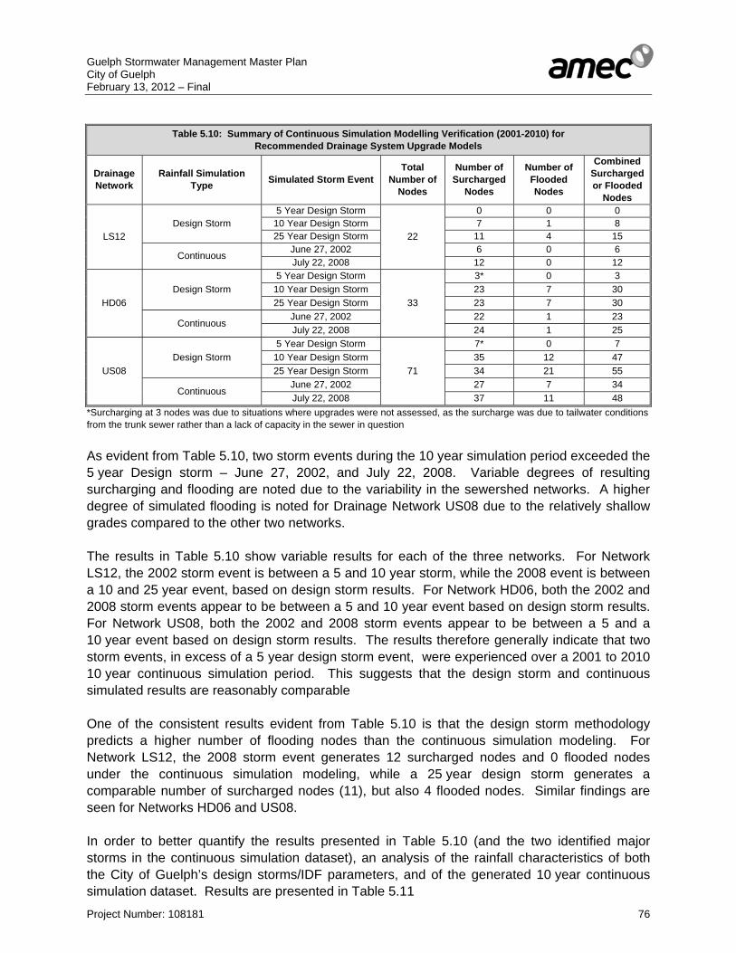
Guelph Stormwater Management Master Plan City of Guelph February 13, 2012 – Final
Project Number: 108181 76
Table 5.10: Summary of Continuous Simulation Modelling Verification (2001-2010) for
Recommended Drainage System Upgrade Models
Drainage Network
Rainfall Simulation Type Simulated Storm Event
Total Number of
Nodes
Number of Surcharged
Nodes
Number of Flooded Nodes
Combined Surcharged or Flooded
Nodes
LS12 Design Storm
5 Year Design Storm
22
0 0 0 10 Year Design Storm 7 1 8 25 Year Design Storm 11 4 15
Continuous June 27, 2002 6 0 6 July 22, 2008 12 0 12
HD06 Design Storm
5 Year Design Storm
33
3* 0 3 10 Year Design Storm 23 7 30 25 Year Design Storm 23 7 30
Continuous June 27, 2002 22 1 23 July 22, 2008 24 1 25
US08 Design Storm
5 Year Design Storm
71
7* 0 7 10 Year Design Storm 35 12 47 25 Year Design Storm 34 21 55
Continuous June 27, 2002 27 7 34 July 22, 2008 37 11 48
*Surcharging at 3 nodes was due to situations where upgrades were not assessed, as the surcharge was due to tailwater conditions from the trunk sewer rather than a lack of capacity in the sewer in question As evident from Table 5.10, two storm events during the 10 year simulation period exceeded the 5 year Design storm – June 27, 2002, and July 22, 2008. Variable degrees of resulting surcharging and flooding are noted due to the variability in the sewershed networks. A higher degree of simulated flooding is noted for Drainage Network US08 due to the relatively shallow grades compared to the other two networks. The results in Table 5.10 show variable results for each of the three networks. For Network LS12, the 2002 storm event is between a 5 and 10 year storm, while the 2008 event is between a 10 and 25 year event, based on design storm results. For Network HD06, both the 2002 and 2008 storm events appear to be between a 5 and 10 year event based on design storm results. For Network US08, both the 2002 and 2008 storm events appear to be between a 5 and a 10 year event based on design storm results. The results therefore generally indicate that two storm events, in excess of a 5 year design storm event, were experienced over a 2001 to 2010 10 year continuous simulation period. This suggests that the design storm and continuous simulated results are reasonably comparable One of the consistent results evident from Table 5.10 is that the design storm methodology predicts a higher number of flooding nodes than the continuous simulation modeling. For Network LS12, the 2008 storm event generates 12 surcharged nodes and 0 flooded nodes under the continuous simulation modeling, while a 25 year design storm generates a comparable number of surcharged nodes (11), but also 4 flooded nodes. Similar findings are seen for Networks HD06 and US08. In order to better quantify the results presented in Table 5.10 (and the two identified major storms in the continuous simulation dataset), an analysis of the rainfall characteristics of both the City of Guelph’s design storms/IDF parameters, and of the generated 10 year continuous simulation dataset. Results are presented in Table 5.11
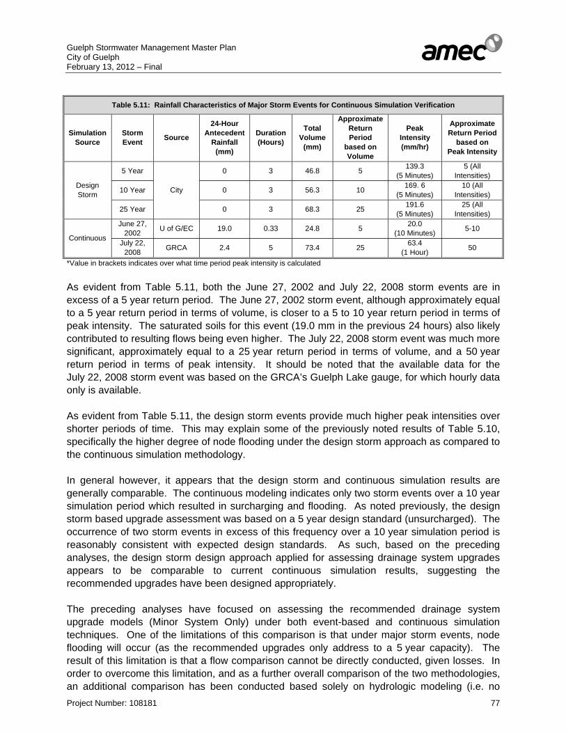
Guelph Stormwater Management Master Plan City of Guelph February 13, 2012 – Final
Project Number: 108181 77
Table 5.11: Rainfall Characteristics of Major Storm Events for Continuous Simulation Verification
Simulation Source
Storm Event Source
24-Hour Antecedent
Rainfall (mm)
Duration (Hours)
Total Volume
(mm)
Approximate Return Period
based on Volume
Peak Intensity (mm/hr)
Approximate Return Period
based on Peak Intensity
Design Storm
5 Year
City
0 3 46.8 5 139.3 (5 Minutes)
5 (All Intensities)
10 Year 0 3 56.3 10 169. 6 (5 Minutes)
10 (All Intensities)
25 Year 0 3 68.3 25 191.6 (5 Minutes)
25 (All Intensities)
Continuous
June 27, 2002 U of G/EC 19.0 0.33 24.8 5 20.0
(10 Minutes) 5-10
July 22, 2008 GRCA 2.4 5 73.4 25 63.4
(1 Hour) 50
*Value in brackets indicates over what time period peak intensity is calculated As evident from Table 5.11, both the June 27, 2002 and July 22, 2008 storm events are in excess of a 5 year return period. The June 27, 2002 storm event, although approximately equal to a 5 year return period in terms of volume, is closer to a 5 to 10 year return period in terms of peak intensity. The saturated soils for this event (19.0 mm in the previous 24 hours) also likely contributed to resulting flows being even higher. The July 22, 2008 storm event was much more significant, approximately equal to a 25 year return period in terms of volume, and a 50 year return period in terms of peak intensity. It should be noted that the available data for the July 22, 2008 storm event was based on the GRCA’s Guelph Lake gauge, for which hourly data only is available. As evident from Table 5.11, the design storm events provide much higher peak intensities over shorter periods of time. This may explain some of the previously noted results of Table 5.10, specifically the higher degree of node flooding under the design storm approach as compared to the continuous simulation methodology. In general however, it appears that the design storm and continuous simulation results are generally comparable. The continuous modeling indicates only two storm events over a 10 year simulation period which resulted in surcharging and flooding. As noted previously, the design storm based upgrade assessment was based on a 5 year design standard (unsurcharged). The occurrence of two storm events in excess of this frequency over a 10 year simulation period is reasonably consistent with expected design standards. As such, based on the preceding analyses, the design storm design approach applied for assessing drainage system upgrades appears to be comparable to current continuous simulation results, suggesting the recommended upgrades have been designed appropriately. The preceding analyses have focused on assessing the recommended drainage system upgrade models (Minor System Only) under both event-based and continuous simulation techniques. One of the limitations of this comparison is that under major storm events, node flooding will occur (as the recommended upgrades only address to a 5 year capacity). The result of this limitation is that a flow comparison cannot be directly conducted, given losses. In order to overcome this limitation, and as a further overall comparison of the two methodologies, an additional comparison has been conducted based solely on hydrologic modeling (i.e. no
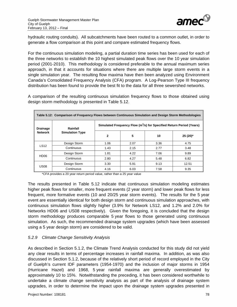
Guelph Stormwater Management Master Plan City of Guelph February 13, 2012 – Final
Project Number: 108181 78
hydraulic routing conduits). All subcatchments have been routed to a common outlet, in order to generate a flow comparison at this point and compare estimated frequency flows. For the continuous simulation modeling, a partial duration time series has been used for each of the three networks to establish the 10 highest simulated peak flows over the 10 year simulation period (2001-2010). This methodology is considered preferable to the annual maximum series approach, in that it accounts for situations where there are multiple large storm events in a single simulation year. The resulting flow maxima have then been analyzed using Environment Canada’s Consolidated Frequency Analysis (CFA) program. A Log-Pearson Type III frequency distribution has been found to provide the best fit to the data for all three sewershed networks. A comparison of the resulting continuous simulation frequency flows to those obtained using design storm methodology is presented in Table 5.12.
Table 5.12: Comparison of Frequency Flows between Continuous Simulation and Design Storm Methodologies
Drainage Network
Rainfall Simulation Type
Simulated Frequency Flow (m3/s) for Specified Return Period (Years)
2 5 10 25 (20)*
LS12 Design Storm 1.06 2.07 3.36 4.75 Continuous 1.43 2.15 2.77 3.48
HD06 Design Storm 1.81 4.22 7.06 9.89 Continuous 2.80 4.27 5.48 6.82
US08 Design Storm 3.30 5.91 9.13 12.51 Continuous 4.16 6.03 7.58 9.35
*CFA provides a 20 year return period value, rather than a 25 year value The results presented in Table 5.12 indicate that continuous simulation modeling estimates higher peak flows for smaller, more frequent events (2 year storm) and lower peak flows for less frequent, more formative events (10 and 20/25 year storm events). The results for the 5 year event are essentially identical for both design storm and continuous simulation approaches, with continuous simulation flows slightly higher (3.9% for Network LS12, and 1.2% and 2.0% for Networks HD06 and US08 respectively). Given the foregoing, it is concluded that the design storm methodology produces comparable 5 year flows to those generated using continuous simulation. As such, the recommended drainage system upgrades (which have been assessed using a 5 year design storm) are considered to be valid. 5.2.9 Climate Change Sensitivity Analysis As described in Section 5.1.2, the Climate Trend Analysis conducted for this study did not yield any clear results in terms of percentage increases in rainfall maxima. In addition, as was also discussed in Section 5.1.2, because of the relatively short period of record employed in the City of Guelph’s current IDF parameters (1954-1970) and the inclusion of major storms in 1954 (Hurricane Hazel) and 1968, 5 year rainfall maxima are generally overestimated by approximately 10 to 15%. Notwithstanding the preceding, it has been considered worthwhile to undertake a climate change sensitivity analysis as part of the analysis of drainage system upgrades, in order to determine the impact upon the drainage system upgrades presented in
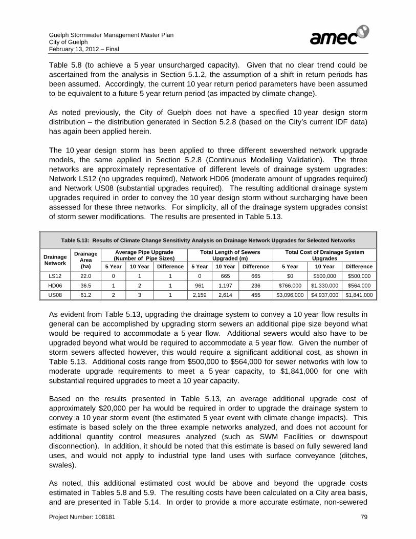
Guelph Stormwater Management Master Plan City of Guelph February 13, 2012 – Final
Project Number: 108181 79
Table 5.8 (to achieve a 5 year unsurcharged capacity). Given that no clear trend could be ascertained from the analysis in Section 5.1.2, the assumption of a shift in return periods has been assumed. Accordingly, the current 10 year return period parameters have been assumed to be equivalent to a future 5 year return period (as impacted by climate change). As noted previously, the City of Guelph does not have a specified 10 year design storm distribution – the distribution generated in Section 5.2.8 (based on the City’s current IDF data) has again been applied herein. The 10 year design storm has been applied to three different sewershed network upgrade models, the same applied in Section 5.2.8 (Continuous Modelling Validation). The three networks are approximately representative of different levels of drainage system upgrades: Network LS12 (no upgrades required), Network HD06 (moderate amount of upgrades required) and Network US08 (substantial upgrades required). The resulting additional drainage system upgrades required in order to convey the 10 year design storm without surcharging have been assessed for these three networks. For simplicity, all of the drainage system upgrades consist of storm sewer modifications. The results are presented in Table 5.13.
Table 5.13: Results of Climate Change Sensitivity Analysis on Drainage Network Upgrades for Selected Networks
Drainage Network
Drainage Area (ha)
Average Pipe Upgrade (Number of Pipe Sizes)
Total Length of Sewers Upgraded (m)
Total Cost of Drainage System Upgrades
5 Year 10 Year Difference 5 Year 10 Year Difference 5 Year 10 Year Difference
LS12 22.0 0 1 1 0 665 665 $0 $500,000 $500,000
HD06 36.5 1 2 1 961 1,197 236 $766,000 $1,330,000 $564,000
US08 61.2 2 3 1 2,159 2,614 455 $3,096,000 $4,937,000 $1,841,000
As evident from Table 5.13, upgrading the drainage system to convey a 10 year flow results in general can be accomplished by upgrading storm sewers an additional pipe size beyond what would be required to accommodate a 5 year flow. Additional sewers would also have to be upgraded beyond what would be required to accommodate a 5 year flow. Given the number of storm sewers affected however, this would require a significant additional cost, as shown in Table 5.13. Additional costs range from $500,000 to $564,000 for sewer networks with low to moderate upgrade requirements to meet a 5 year capacity, to $1,841,000 for one with substantial required upgrades to meet a 10 year capacity. Based on the results presented in Table 5.13, an average additional upgrade cost of approximately $20,000 per ha would be required in order to upgrade the drainage system to convey a 10 year storm event (the estimated 5 year event with climate change impacts). This estimate is based solely on the three example networks analyzed, and does not account for additional quantity control measures analyzed (such as SWM Facilities or downspout disconnection). In addition, it should be noted that this estimate is based on fully sewered land uses, and would not apply to industrial type land uses with surface conveyance (ditches, swales). As noted, this additional estimated cost would be above and beyond the upgrade costs estimated in Tables 5.8 and 5.9. The resulting costs have been calculated on a City area basis, and are presented in Table 5.14. In order to provide a more accurate estimate, non-sewered
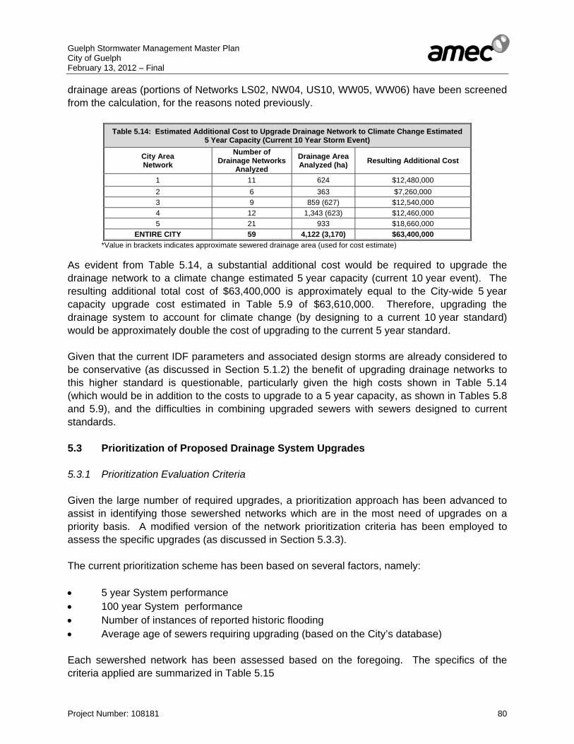
Guelph Stormwater Management Master Plan City of Guelph February 13, 2012 – Final
Project Number: 108181 80
drainage areas (portions of Networks LS02, NW04, US10, WW05, WW06) have been screened from the calculation, for the reasons noted previously.
Table 5.14: Estimated Additional Cost to Upgrade Drainage Network to Climate Change Estimated 5 Year Capacity (Current 10 Year Storm Event)
City Area Network
Number of Drainage Networks
Analyzed Drainage Area Analyzed (ha) Resulting Additional Cost
1 11 624 $12,480,000 2 6 363 $7,260,000 3 9 859 (627) $12,540,000 4 12 1,343 (623) $12,460,000 5 21 933 $18,660,000
ENTIRE CITY 59 4,122 (3,170) $63,400,000 *Value in brackets indicates approximate sewered drainage area (used for cost estimate)
As evident from Table 5.14, a substantial additional cost would be required to upgrade the drainage network to a climate change estimated 5 year capacity (current 10 year event). The resulting additional total cost of $63,400,000 is approximately equal to the City-wide 5 year capacity upgrade cost estimated in Table 5.9 of $63,610,000. Therefore, upgrading the drainage system to account for climate change (by designing to a current 10 year standard) would be approximately double the cost of upgrading to the current 5 year standard. Given that the current IDF parameters and associated design storms are already considered to be conservative (as discussed in Section 5.1.2) the benefit of upgrading drainage networks to this higher standard is questionable, particularly given the high costs shown in Table 5.14 (which would be in addition to the costs to upgrade to a 5 year capacity, as shown in Tables 5.8 and 5.9), and the difficulties in combining upgraded sewers with sewers designed to current standards. 5.3 Prioritization of Proposed Drainage System Upgrades 5.3.1 Prioritization Evaluation Criteria Given the large number of required upgrades, a prioritization approach has been advanced to assist in identifying those sewershed networks which are in the most need of upgrades on a priority basis. A modified version of the network prioritization criteria has been employed to assess the specific upgrades (as discussed in Section 5.3.3). The current prioritization scheme has been based on several factors, namely: • 5 year System performance • 100 year System performance • Number of instances of reported historic flooding • Average age of sewers requiring upgrading (based on the City’s database) Each sewershed network has been assessed based on the foregoing. The specifics of the criteria applied are summarized in Table 5.15
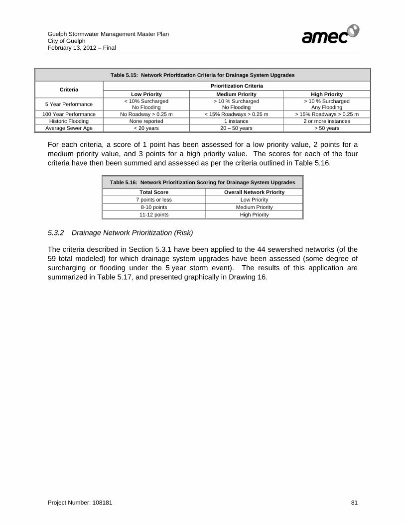
Guelph Stormwater Management Master Plan City of Guelph February 13, 2012 – Final
Project Number: 108181 81
Table 5.15: Network Prioritization Criteria for Drainage System Upgrades
Criteria Prioritization Criteria
Low Priority Medium Priority High Priority
5 Year Performance < 10% Surcharged No Flooding
> 10 % Surcharged No Flooding
> 10 % Surcharged Any Flooding
100 Year Performance No Roadway > 0.25 m < 15% Roadways > 0.25 m > 15% Roadways > 0.25 m Historic Flooding None reported 1 instance 2 or more instances
Average Sewer Age < 20 years 20 – 50 years > 50 years For each criteria, a score of 1 point has been assessed for a low priority value, 2 points for a medium priority value, and 3 points for a high priority value. The scores for each of the four criteria have then been summed and assessed as per the criteria outlined in Table 5.16.
Table 5.16: Network Prioritization Scoring for Drainage System Upgrades
Total Score Overall Network Priority 7 points or less Low Priority
8-10 points Medium Priority 11-12 points High Priority
5.3.2 Drainage Network Prioritization (Risk) The criteria described in Section 5.3.1 have been applied to the 44 sewershed networks (of the 59 total modeled) for which drainage system upgrades have been assessed (some degree of surcharging or flooding under the 5 year storm event). The results of this application are summarized in Table 5.17, and presented graphically in Drawing 16.
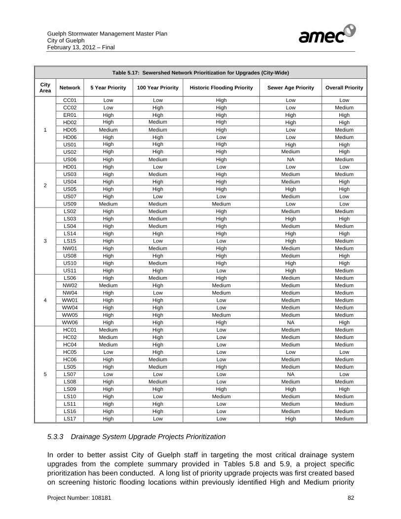
Guelph Stormwater Management Master Plan City of Guelph February 13, 2012 – Final
Project Number: 108181 82
Table 5.17: Sewershed Network Prioritization for Upgrades (City-Wide)
City Area Network 5 Year Priority 100 Year Priority Historic Flooding Priority Sewer Age Priority Overall Priority
1
CC01 Low Low High Low Low CC02 Low High High Low Medium ER01 High High High High High HD02 High Medium High High High HD05 Medium Medium High Low Medium HD06 High High Low Low Medium US01 High High High High High US02 High High High Medium High US06 High Medium High NA Medium
2
HD01 High Low Low Low Low US03 High Medium High Medium Medium US04 High High High Medium High US05 High High High High High US07 High Low Low Medium Low US09 Medium Medium Medium Low Low
3
LS02 High Medium High Medium Medium LS03 High Medium High High High LS04 High Medium High Medium Medium LS14 High High High High High LS15 High Low Low High Medium NW01 High Medium High Medium Medium US08 High High High Medium High US10 High Medium High High High US11 High High Low High Medium
4
LS06 High Medium High Medium Medium NW02 Medium High Medium Medium Medium NW04 High Low Medium Medium Medium WW01 High High Low Medium Medium WW04 High High Low Medium Medium WW05 High High Medium Medium Medium WW06 High High High NA High
5
HC01 Medium High Low Medium Medium HC02 Medium High Low Medium Medium HC04 Medium High Low Medium Medium HC05 Low High Low Low Low HC06 High Medium Low Medium Medium LS05 High Medium High Medium Medium LS07 Low Low Low NA Low LS08 High Medium Low Medium Medium LS09 High High High High High LS10 High Low Medium Medium Medium LS11 High High Low Medium Medium LS16 High High Low Medium Medium LS17 High Low Low High Medium
5.3.3 Drainage System Upgrade Projects Prioritization In order to better assist City of Guelph staff in targeting the most critical drainage system upgrades from the complete summary provided in Tables 5.8 and 5.9, a project specific prioritization has been conducted. A long list of priority upgrade projects was first created based on screening historic flooding locations within previously identified High and Medium priority

Guelph Stormwater Management Master Plan City of Guelph February 13, 2012 – Final
Project Number: 108181 83
sewershed networks (as identified in Table 5.17). This long list of approximately 40 locations has then been analyzed based on a number of factors, including: • Number of historic flooding sites affected by proposed upgrade • Whether the upgrade affects other identified priority upgrades (i.e. must be completed
prior to proceeding with other work) • Magnitude of recommended upgrade (1 pipe size, 2 pipe sizes, 3 or more pipe sizes) • Whether or not the upgrade is along or would affect City of Guelph identified Emergency
Evacuation Routes • Estimated cost per flooding site affected Given the number of factors considered, and the complexity of each upgrade and the inter-connection between several of them, no specific numeric ranking scheme system has been employed for this prioritization. Rather, each of the long-listed sites has been analyzed individually, based on the previously noted criteria. The order of the previously noted criteria has been used as a general guide of importance, with number of historic flooding sites affected being the critical criteria. By applying this criteria, a ranking has been developed, and the top 25 priority drainage system upgrades identified. The results are presented in Table 5.18.

Guelph Stormwater Management Master Plan City of Guelph February 13, 2012 – Final
Project Number: 108181 84
Table 5.18: Top 25 Prioritized Drainage System Upgrades (Quantity Control)
Assigned Priority Network
Overall Network Priority
Project Description Class EA Process Schedule
Number of Historic Flooding
Sites Affected
Historic Flooding
Site Numbers
Length of Sewer
Upgraded or Added
(m)
Average Upgrade
Requirement (Number of Pipe Sizes)
Average Age of
Existing Sewer (Years)
Estimated Cost
Affects other
priority upgrades?
Dependant on other
work being
done first?
Along Evacuation Route, or
affects one?
Notes
NA Selected Ones NA Downspout disconnection
program NA - Bylaw Required NA NA NA NA NA $627,000 Yes No NA
Would significantly help in reducing flows to the sewer system, particularly in identified problem areas. Would ideally be City-wide, but if not, target identified areas (Networks HD02, LS05, LS06, LS09, US03, US04, US05). Sewer sizing (and therefore costs) for upgrade projects within those identified networks are based on this assumption. Cost for program is only for identified networks, and does not include educational program.
1 LS04 Medium Trunk Sewer (Raymond to Speed River) A+ 6 4, 5, 7, 30,
110, 139 140 3 NA $388,000 Yes No No Likely the first step in addressing issues as this is the trunk outlet section that drains all of LS04. This section would need to be done prior to other upgrades
2 HD02 High Green Meadows SWM Facility B 5 102, 103, 141, 143, 172 NA NA NA $1,100,000 Yes No Yes
Significant facility size required. Would help alleviate significant issues with trunk sewer downstream by reducing peak flows. Would likely be combined with Priority Project 3 (Eramosa/Stevenson Diversion). Includes piece of trunk sewer on Stevenson between MH confluence and diversion to SWM. Includes upgrade of sewer through park/school at same time to minimize backwater effects. Constrained by flat sewer grades.
3 HD02 High
Eramosa Road (Skov to Stevenson) and Stevenson Street (Eramosa to Bennett), and Lane Street (Erin to Stevenson)
A+ 5 43, 44, 127, 159, 160 659 3 NA $2,547,000 Yes No Yes
High cost associated with large size pipe and use of HE pipe over circular to keep WLs down. Major flow diversion - involves disconnecting from trunk through Zehrs plaza which would also save capacity through that section. Relatively deep excavation (estimated 5.9 m at deepest point). Also includes a section on Lane street to eliminate storm sewer passing through private property.
4 HD02 High Bennett Avenue (Winston to Stevenson) A+ 4 43, 44, 91,
132 368 2 59 $138,000 No No No Combination of upgrade and diversion to limit flows towards Lane Street which has had repeated flooding (disconnection at Lane and Bennett). Keep sewer high to avoid backwater.
5 LS04 Medium Bristol, Holliday and Raymond Street Diversion A+ 4 4, 5, 7, 30 459 3 53 $404,000 Yes Yes No Since it is a diversion (new pipes) would likely have to do it all at once
6 HD02 High Trunk Sewer (rail line to Elizabeth Street) A+ 3 25, 26, 152 109 3 NA $461,000 Yes No Yes Size to include diversion along William Street. Include work downstream to connect to relief box culvert on
Elizabeth. Costs likely higher due to need to upgrade under rail line. Slightly oversized to be consistent with U/S.
7 HD02 High Ward 1 Quality/Quantity control facility and outlet channel works (to connection with existing 1200)
B 3 25, 26, 152 NA NA NA $300,000 Yes No No As detailed in Ward 1 SWM EA Report, 2007. Class EA approval received. Estimated cost from that document. Design should utilize flows from AMEC MP model as it is more detailed, calibrated, and gives higher flows – which will likely require a quantity control function, not accounted for in original EA.
8 NW01 Medium Paisley Road (Western to Silvercreek) A+ 2 134, 155 422 3 52 $188,000 No No Yes Addresses frequent flooding issue noted previously by the City
9 LS14 High Edinburgh Road (Bristol Street to Speed River) A+ 1 18 195 3 NA $235,000 Yes No Yes Would be the most critical section - where roadway and sewer flatten out after steep grade. This would need to be
done prior to doing rest of Edinburgh
10 HD02 High Cassino Avenue (Hadati to Victoria) A+ 4 34, 35, 123,
193 276 3 NA $381,000 Yes No No Appears to be significantly undersized, number of historic flooding concerns - would likely require putting in proposed relief sewer along Victoria at some point later on
11 US04 High Montana Road (Brant to Woodlawn) A+ 4 49, 135, 190,
194 400 3 46 $643,000 Yes No No Addresses frequent flooding spots. Would likely require further upgrades downstream at a later point.
12 LS14 High Bristol Street (Edinburgh to McGee) A+ 3 6, 18, 61 61 3 57 $46,000 No Yes No Not full costing - only includes portion analyzed. Major upsizing in part to divert flow from going down Raymond.
Section on Edinburgh would have to be done first.
13 US08 High
Trunk Sewer along Rail Trail between Exhibition and Woolwich, and Woolwich Street (Rail to Earl)
A+ 2 17, 27 393 3 41 $1,678,000 Yes No No Using box culvert section - high cost. Includes upgrade along Woolwich since makes sense to do this at the same time. Upgrade on Earl is relatively minor and could therefore be delayed. Upgrade along rail line considered, but too far and too expensive.
14 US08 High Exhibition Street (Stanley to Powell) A+ 2 17, 27 761 3 NA $850,000 Yes Yes No Full section along Exhibition - includes both new diversion sewer to north of rail line (removes flow from private
property storm sewer) and upgrade to south. Would likely go further south to upgrade existing small 225 sewers
15 HD02 High William Street (Edmonton to CNR) and Normandy Street (Trunk to William)
A+ 3 88, 89, 172 895 3 57 $2,343,000 No Yes No
Significant diversion - sized to include additional flow based on disconnecting at Ottawa and Meyer to address flood sites 153 and 162 (not included in estimate). Assumes disconnection at Franchetto and Cassino in order to save capacity in existing trunk. Flow balancer/relief at Normandy included with estimate. Would need rail culvert and other works downstream done first.
16 US08 High Division Street (Princess to Exhibition) A+ 2 17, 27 134 3 31 $33,000 No Yes No Contingent on upgrading rail line sewer and Exhibition Street sewer
17 HD02 High Grange Street (Stevenson to Trunk Sewer) A+ 2 103, 172 179 3 NA $316,000 No Yes No
Significant upgrade - actual works would likely be more extensive - only summarizing portion analyzed. Sized to include a diversion from Palmer Street via Louisa Drive to divert flow from 450 on private property. Would be dependent on works upstream to take flow out of overloaded trunk. Includes diversion to William St to eliminate sewer on private property.
18 LS04 Medium Wellington Street (Dublin Street to Trunk) A+ 2 110, 139 406 3 NA $903,000 No Yes Yes Includes proposed diversion. Might be more extensive - uncertainty of existing grades in relation to Gordon Street
work (no as-builts)
19 US03 Medium Waverly SWM Facility B 1 69 NA NA NA $680,000 No No No Additional reported flooding along Stevenson not shown on maps (as per preliminary SWM design report). Limited storage volume possible – would still require upgrades downstream. Potential for second facility on easement.
20 LS14 High Edinburgh Road (Preston to Bristol) A+ 1 18 331 2 NA $93,000 No No Yes Relatively cost effective upgrade given smaller size of required storm sewers. Construction might be affected by
steep grades.
21 HD02 High Victoria Road (Eastview to Brunswick) A+ 1 81 345 3 NA $162,000 No No Yes
Upgrade to work done in 2010 which connected 525 into a 300 - upsize down to Brunswick Ave, however long term would be to continue diversion/relief down Victoria (to proposed Franchetto Park SWM) and remove flow from Brunswick. Plan calls for disconnection from existing parallel trunk sewer near Eastview.
22 ER01 High Brockville Avenue (York Road to Eramosa River) A+ 1 144 325 3 92 $393,000 No No Yes Appears to be one of the oldest section of storm sewer analyzed (almost 100 years old). Definitely undersized given
size of all the other sewers coming in. Would involve raising outlet invert as well to avoid backwater from river.
23 US06 Medium Grove Street (Regent Street to approximately 250 m easterly) A+ 1 106 249 2 NA $58,000 No No No Could expand to include portion further east (that section not modelled)
24 US08 High St Andrew Street (Robertson to Exhibition) and part of Robertson Street
A+ 1 71 198 3 58 $172,000 No Yes No Contingent on upgrading rail line sewer and Exhibition Street sewer - includes diversion to Exhibition street to bypass private property storm sewer
25 LS02 Medium Silvercreek SWM Facility B 1 112 NA NA NA $621,000 No No No As detailed in “Storm Water Management Report: Howitt Creek at the Silvercreek Parkway Site”, August 2008. Cost estimate from that study. Design should utilize flows from AMEC MP model as it is more detailed, calibrated, and gives higher flows and therefore higher volumes. Priority may be higher depending on development timing.
TOTAL NA NA Top 25 Projects Total NA 44 NA 7,305 NA 56 $15,760,000 NA NA NA NA
Guelph Stormwater Management Master Plan City of Guelph February 13, 2012 – Final
Project Number: 108181 85
As evident from Table 5.18, the identified priority drainage system upgrades are primarily located in older areas of the City in several key networks, in particular Networks HD02, LS04, LS14, and US08. They would address a total of 44 different identified flooding locations. As noted previously, these upgrades relate only to achieving a 5 year unsurcharged capacity, and have not been assessed with respect to effectiveness at reducing major system overland flooding (100 year event). Although not a direct infrastructure upgrade, a key priority as noted in Table 5.18 should also be the implementation of a downspout disconnection program, particularly within the identified priority sewershed networks, or ideally city-wide. This would greatly assist in reducing inflows to the storm sewer system, and help reduce the number and magnitude of infrastructure upgrades. Given the pervious soils within the City (generally loams and sandy loams), infiltration of relatively clean roof water runoff would be effective and would have incidental benefits related to groundwater recharge. As noted, upgrade sizing (and therefore costing) within the networks with recommended downspout disconnection programs have been based on that assumption. The upgrade projects listed in Table 5.18 are focused on infrastructure upgrades, primarily related to storm sewers, as well as stormwater management facilities. It should be noted that these upgrades have not been assessed directly with respect to basement flooding, as there are numerous potential causes, the majority of which are related to the sanitary sewer connection (not addressed by this study). Cases of basement flooding should be examined individually for potential causes. Foundation drains (such as weeping tiles or sump pumps) should ideally discharge to the surface rather than into the storm sewer. Backflow preventers should also be considered for implementation. This issue should be considered in greater detail as part of a review of the City’s stormwater management policy (as discussed in Section 7.6). Sanitary sewer improvements should also be considered in conjunction with the recommended storm sewer upgrades in areas prone to basement flooding. As noted previously, the high number of storm sewers located on private property (as shown in Drawing 8) are also a concern. Where possible, the previously noted upgrades have attempted to bypass or limit flows to these sewers, given issues related to maintenance and access. A long-term strategy for removal, diversion, or property purchase should be considered in conjunction with a review of the City’s stormwater management policies, as discussed in Section 7.6. The total cost for the 25 prioritized projects detailed in Table 5.18 is estimated as $15,760,000. Although this prioritized total cost is significantly lower than the City-wide total cost of $63,610,000 (as detailed in Tables 5.8 and 5.9), it is acknowledged that the costs are still significant. A discussion of potential funding sources is detailed in Section 7.5.
Guelph Stormwater Management Master Plan City of Guelph February 13, 2012 – Final
Project Number: 108181 86
5.4 Infill and Intensification Flood Storage Assessment The previous hydrologic/hydraulic analyses have focused on assessing deficiencies in the existing storm drainage system, based on existing land use (with the exception of the simulation of the impact of downspout disconnection programs). However, the impact of future infill and intensification land use on storm drainage, and the associated requirement for flood storage (quantity control) also needs to be considered (premised on the potential for greater land coverage with hard surfaces). As noted previously, it is projected that by 2015 the overall share of infill and intensification residential growth will gradually increase to 40 percent of new residential development or more. Without consideration for the potential need for additional flood storage (quantity control), infill and intensification projects within the City’s existing urban built boundary can add additional strain to the storm drainage system, beyond the previously identified deficiencies.
As such, it has been considered necessary to undertake a flood storage assessment, in order to determine the approximate volume requirements to mitigate potential increases in runoff peak flows associated with infill and intensification land use. Given the relative scale of the current study (Master Plan level), it has not been the intention of the assessment to provide site-specific storage requirements, rather this assessment has been based on a sewershed level, as has been applied in previous analyses. The storage requirements outlined by this assessment can therefore be used as a higher-level overview in order to guide decisions on the need for larger-scale public storage facilities as opposed to lot-level solutions. It is acknowledged that a more refined assessment would be required once the specifics of the infill and intensification development are known within a sewershed, as well as factors such as the choice of storage type and location, and the specific impact on local drainage infrastructure and previously recommended drainage system upgrades. It is also acknowledged that this assessment does not address all identified infill and intensification lands, but rather only those within modeled sewershed networks. The analysis has applied a lumped approach to assessing storage requirements. The methodology applied has been outlined in the following: 1. The calibrated existing land use conditions modeling has been used as a base to identify
the target outlet peak flows to which future conditions (infill/intensification) should be controlled to; the following has been considered:
- To avoid the effect of undersized drainage infrastructure, all sub-catchments
have been routed directly to the sewershed outlet. - Where multiple outlets existing for a network, the largest outlet has been
employed for the entire network. - An exception has been made for those quantity control facilities located within a
network (i.e. not located at the ultimate network outlet), in order to account for the associated impact. The connected sub-catchments are first routed into this facility, and the resulting outflow is then routed directly to the outlet. As with previous sewershed analyses, end-of-pipe stormwater management facilities are not considered (assumption of a free outfall).

Guelph Stormwater Management Master Plan City of Guelph February 13, 2012 – Final
Project Number: 108181 87
- The resulting modified model has then been executed for the City of Guelph’s standard 5 year and 100 year design storms to obtain the resulting target flows. In order to generate an intermediate point, the 25 year storm event peak flows have also been generated (3-Hour Chicago distribution, based on the City of Guelph’s IDF parameters).
2. The modified existing land use conditions model is then used as the base for the future
conditions infill/intensification assessment. The following has been considered in the future conditions model:
- Infill and intensification parcel mapping supplied by the City of Guelph (from the
City’s Growth Management Strategy – Residential Intensification Analysis Report) has been overlain on the sub-catchment mapping for each network in order to determine which networks and associated sub-catchments would incur infill/intensification.
- Where an infill/intensification area (I/I) would be proposed, future land use parameters have been modified based on the following assumptions (based on the associated densities from the previously noted Growth Management Strategy):
Medium Intensity I/I= 60% total imperviousness, 30% directly connected imperviousness
Medium-High Intensity I/I= 90% total/directly connected imperviousness High Intensity I/I= 90% total/directly connected imperviousness
- An assumption has been made that the existing drainage boundaries would all remain unchanged under infill/intensification land use
- No land use parameter changes have been assessed for commercial or other highly impervious areas, since these lands are essentially completely impervious, and intensification would not result in a change in impervious coverages.
- All sub-catchments (including those updated to reflect the proposed infill/intensification areas) have then been routed through a hypothetical single stormwater management facility prior to discharging to the outlet.
The rating curve for the hypothetical facility uses the existing peak flows (5, 25, and 100 year storms) as flow ordinates. The associated storages have been determined incrementally by assessing each storm in turn, in order to develop a realistic rating curve for the Network as a whole.
The foregoing technique has been applied to 59 sewershed networks in which infill/ intensification has been currently proposed. The resulting intensification areas and associated flood storage volumes are provided in Table 5.19, with the associated unitary storage rates provided in Table 5.20.

Guelph Stormwater Management Master Plan City of Guelph February 13, 2012 – Final
Project Number: 108181 88
Table 5.19: Infill and Intensification Flood Storage Requirements by Sewershed
City Area Network
Infill and Intensification Area (ha) for Specified Intensification Class
Flood Storage Requirement (m3) for Specified Return Period (Years)
Medium Medium-High High Total 5 Year 25 Year 100 Year
1
CC01 2.09 0.28 0.00 2.37 470 780 990 ER01 1.03 2.07 0.00 3.10 380 640 880 HD02 0.00 20.91 0.00 20.91 3,900 6,540 8,560 HD03 2.40 0.00 0.00 2.40 370 650 850 HD06 10.19 0.00 0.00 10.19 1,270 1,960 2,430 US01 0.23 5.19 15.04 20.46 2,980 4,830 6,380 US02 0.00 0.00 14.12 14.12 670 990 1240 US06 0.00 0.41 0.00 0.41 150 250 320
TOTAL 15.94 28.86 29.16 73.96 10,190 16,640 21,650
2
HD01 0.00 0.48 0.00 0.48 0 0 0 US03 0.00 19.81 0.00 19.81 1,990 3,510 4,770 US04 0.00 5.76 0.00 5.76 830 1,350 1,730 US05 0.00 1.88 0.00 1.88 440 720 960 US07 0.00 0.00 5.98 5.98 980 1,440 1,770 US09 0.00 2.87 2.68 5.55 620 1,000 1,340
TOTAL 0.00 30.80 8.66 39.46 4,860 8,020 10,570
3
LS02 0.00 32.25 3.22 35.47 4,430 7,800 10,670 LS03 0.00 8.63 2.11 10.74 2,650 4,550 6,010 LS04 0.00 0.05 8.82 8.87 1,060 1,640 2,090 LS14 0.00 0.97 0.00 0.97 140 230 310 NW01 0.00 0.00 9.67 9.67 1,160 1,850 2,380 US08 0.00 6.52 0.00 6.52 1,340 2,370 3,170 US10 0.00 0.00 1.33 1.33 120 210 300 US11 0.00 10.20 0.00 10.20 1,520 2,610 3,570
TOTAL 0.00 58.62 25.15 83.77 12,420 21,260 28,500
4
LS06 0.00 4.38 0.29 4.67 1,500 2,570 3,380 NW02 0.00 2.65 0.00 2.65 440 790 1,100 NW04 0.00 2.71 21.59 24.30 2,010 3,980 7,250 WW03 0.00 6.53 0.23 6.76 2,070 3,430 4,490 WW05 0.00 18.87 0.00 18.87 2,780 4,260 5,360 WW06 0.00 5.16 0.00 5.16 1,460 2,810 4,620 WW07 0.00 0.79 0.00 0.79 260 500 680 WW08 0.00 0.42 0.00 0.42 140 250 340 TOTAL 0.00 41.51 22.11 63.62 10,660 18,590 27,220
5
HC02 0.00 0.76 0.00 0.76 0 0 0 HC06 0.00 1.73 0.00 1.73 220 370 480 HC08 0.04 0.00 0.00 0.04 0 0 0 HC10 0.90 0.00 0.00 0.90 120 260 370 LS05 8.34 8.69 20.97 38.00 4,090 6,730 8,960 LS07 0.00 1.14 0.00 1.14 320 600 910 LS08 0.00 0.00 0.20 0.20 80 140 190 LS09 0.00 1.69 0.00 1.69 540 1,030 1,420 LS12 1.18 0.00 0.00 1.18 250 440 570 LS16 0.00 0.00 1.30 1.30 0 0 0
TOTAL 10.46 14.01 22.47 46.94 5,620 9,570 12,900
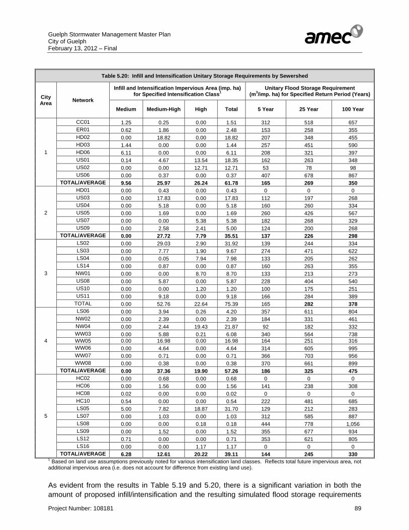
Guelph Stormwater Management Master Plan City of Guelph February 13, 2012 – Final
Project Number: 108181 89
Table 5.20: Infill and Intensification Unitary Storage Requirements by Sewershed
City Area Network
Infill and Intensification Impervious Area (imp. ha) for Specified Intensification Class1
Unitary Flood Storage Requirement (m3/imp. ha) for Specified Return Period (Years)
Medium Medium-High High Total 5 Year 25 Year 100 Year
1
CC01 1.25 0.25 0.00 1.51 312 518 657 ER01 0.62 1.86 0.00 2.48 153 258 355 HD02 0.00 18.82 0.00 18.82 207 348 455 HD03 1.44 0.00 0.00 1.44 257 451 590 HD06 6.11 0.00 0.00 6.11 208 321 397 US01 0.14 4.67 13.54 18.35 162 263 348 US02 0.00 0.00 12.71 12.71 53 78 98 US06 0.00 0.37 0.00 0.37 407 678 867
TOTAL/AVERAGE 9.56 25.97 26.24 61.78 165 269 350
2
HD01 0.00 0.43 0.00 0.43 0 0 0 US03 0.00 17.83 0.00 17.83 112 197 268 US04 0.00 5.18 0.00 5.18 160 260 334 US05 0.00 1.69 0.00 1.69 260 426 567 US07 0.00 0.00 5.38 5.38 182 268 329 US09 0.00 2.58 2.41 5.00 124 200 268
TOTAL/AVERAGE 0.00 27.72 7.79 35.51 137 226 298
3
LS02 0.00 29.03 2.90 31.92 139 244 334 LS03 0.00 7.77 1.90 9.67 274 471 622 LS04 0.00 0.05 7.94 7.98 133 205 262 LS14 0.00 0.87 0.00 0.87 160 263 355 NW01 0.00 0.00 8.70 8.70 133 213 273 US08 0.00 5.87 0.00 5.87 228 404 540 US10 0.00 0.00 1.20 1.20 100 175 251 US11 0.00 9.18 0.00 9.18 166 284 389
TOTAL 0.00 52.76 22.64 75.39 165 282 378
4
LS06 0.00 3.94 0.26 4.20 357 611 804 NW02 0.00 2.39 0.00 2.39 184 331 461 NW04 0.00 2.44 19.43 21.87 92 182 332 WW03 0.00 5.88 0.21 6.08 340 564 738 WW05 0.00 16.98 0.00 16.98 164 251 316 WW06 0.00 4.64 0.00 4.64 314 605 995 WW07 0.00 0.71 0.00 0.71 366 703 956 WW08 0.00 0.38 0.00 0.38 370 661 899
TOTAL/AVERAGE 0.00 37.36 19.90 57.26 186 325 475
5
HC02 0.00 0.68 0.00 0.68 0 0 0 HC06 0.00 1.56 0.00 1.56 141 238 308 HC08 0.02 0.00 0.00 0.02 0 0 0 HC10 0.54 0.00 0.00 0.54 222 481 685 LS05 5.00 7.82 18.87 31.70 129 212 283 LS07 0.00 1.03 0.00 1.03 312 585 887 LS08 0.00 0.00 0.18 0.18 444 778 1,056 LS09 0.00 1.52 0.00 1.52 355 677 934 LS12 0.71 0.00 0.00 0.71 353 621 805 LS16 0.00 0.00 1.17 1.17 0 0 0
TOTAL/AVERAGE 6.28 12.61 20.22 39.11 144 245 330 1 Based on land use assumptions previously noted for various intensification land classes. Reflects total future impervious area, not additional impervious area (i.e. does not account for difference from existing land use). As evident from the results in Table 5.19 and 5.20, there is a significant variation in both the amount of proposed infill/intensification and the resulting simulated flood storage requirements
Guelph Stormwater Management Master Plan City of Guelph February 13, 2012 – Final
Project Number: 108181 90
by sewershed network. In addition to the impact of infill/intensification area and type, numerous other factors would affect simulated flood storage requirements, including the nature of the existing land use (undeveloped versus developed) in particular. It should also be noted that not all infill/intensification areas will require quantity control, as noted by those sewershed networks with zero storage specified in Table 5.20. This would reflect areas where the existing land use is of an equal or greater imperviousness than that proposed under intensification. Other sewershed networks have very minor flood storage requirements, which suggests that the increased imperviousness could either be dealt with by minor on-site controls, or, if the sewershed network has no identified drainage system deficiencies, could potentially be allowed to discharge uncontrolled. For those sewershed networks with more significant storage requirements, centralized facilities would likely be preferable to individual site controls, given the issues of maintenance and public control with a high number of individual private controls. Where quantity control facilities have already been proposed as part of the recommended drainage system upgrades, an additional storage volume could be added to provide control for infill and intensification lands. Likewise, a centralized facility required to mitigate infill and intensification areas could also be used to minimize the number of downstream storm sewer upgrades required. The foregoing should be considered as a high-level assessment of the storage requirements to control infill and intensification lands. A more detailed assessment should be conducted to confirm more precise requirements as the details of infill and intensification become more established. 5.5 Low Impact Development Low Impact Development represents the application of a suite of BMPs normally related to source and conveyance stormwater management controls to promote infiltration and pollutant removal on a local site by site basis. These measures rely on eliminating the direct connection between impervious surfaces such as roofs, roads, parking areas, and the storm drainage system, as well as the promotion of infiltration on each development or redevelopment site. General design guidelines and considerations for source and conveyance controls have been advanced since the early 1990’s as part of the MMAH “Making Choices” and in 1994 as part of the Ministry of the original Environment Best Management Practices Guidelines.
Subsequent to the 1994 MOE Guidelines, technologies and standards have been developed further for the application of source and conveyance controls. These have evolved into a class of Best Management Practices (BMPs) referred to as Low Impact Development (LID) practices, which have advanced as an integrated form of site planning and storm servicing to maintain water balance and providing stormwater quality control for urban developments. Initial results from studies in other settings have demonstrated that LID practices may also provide benefits by way of reducing the erosion potential within receiving watercourses and thereby reducing the total volume of end-of-pipe stormwater erosion control requirements. In addition, due to volumetric controls afforded by LID BMP’s, water quality is also improved through a reduction in mass loading. The benefits from LID stormwater management practices are generally focused on the more frequent storm events (e.g. 2 year storm) of lower volumes as opposed to the less
Guelph Stormwater Management Master Plan City of Guelph February 13, 2012 – Final
Project Number: 108181 91
frequent storm events (e.g. 100 year storm) with higher volumes. It is also recognized that the forms of LID practices which promote infiltration or filtration through a granular medium provide thermal mitigation for storm runoff. Guidelines regarding the application of LID practices and techniques have been developed within various jurisdictions in the United States and Canada. Recently, the Toronto and Region Conservation Authority and Credit Valley Conservation have released the 2010 Low Impact Development Stormwater Management Manual, for the design and application of LID measures. Various LID techniques, as well as their function, are summarized in Table 5.21. While LID includes additional planning to implement and can require changing of urban design standards, the information provided in Table 5.21 specifically addresses those techniques and technologies related to stormwater management practices. The City of Guelph has an interest in implementing LID practices not only within new development, but also within existing neighbourhoods. For new development, the City of Guelph will be incorporating LID requirements and guidelines as part of an updated Stormwater Management Policy. For existing neighbourhoods, LID practices would be considered stormwater quantity and quality retrofits and could be implemented within both public and privately owned lands in varying degrees based upon the land use, development form, soil infiltration capacity and the willingness of land owners to modify their property. LID practices would be implemented on priority basis to reduce peak flows within existing drainage networks with capacity constraints. The City of Guelph also proposes to conduct neighbourhood scale pilot projects within these high priority drainage networks. High priority drainage networks for implementing LID practices have been identified on Drawing 15 and Table 5.22. The neighbourhoods identified for implementing LID pilot projects are typically older with larger lots, but with reduced green space within the City owned right-of-way. Each neighbourhood scale LID pilot project will require extensive consultation with the community and an assessment of viable LID practises based on local community input and constraints resulting from the development form. An example of conceptual neighbourhood scale LID retrofit projects within the City of Toronto by the Toronto Region Conservation Authority (TRCA) and the Canada Mortgage and Housing Corporation (CMHC) has been provided in Appendix ‘P’. The neighbourhood scale conceptual LID pilot projects presented in Appendix ‘P’ illustrate the opportunities to apply LID practices within existing historical development of various land uses such as residential, institutional, industrial or mixed. Each neighbourhood is different in age, development form, and infrastructure standards and as such will require appropriate LID practices to be selected accordingly. To provide further detail on the various LID practices, fact sheets developed by CVC and TRCA have also been provided in Appendix ‘P’.
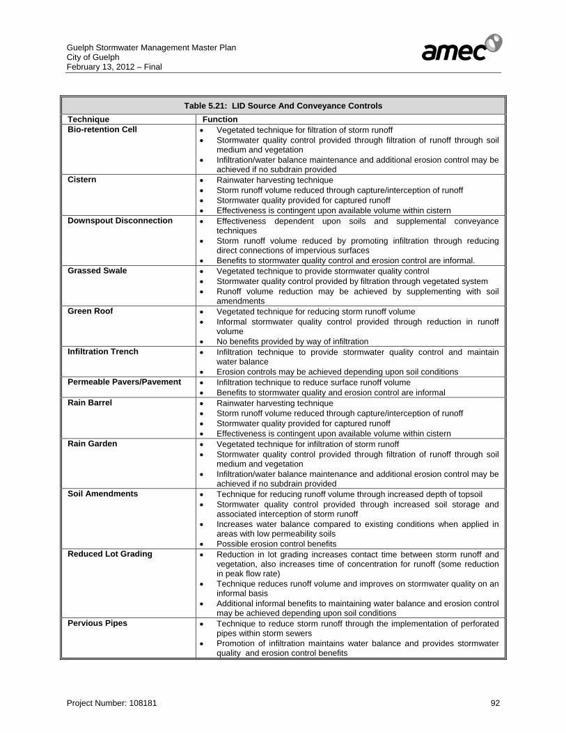
Guelph Stormwater Management Master Plan City of Guelph February 13, 2012 – Final
Project Number: 108181 92
Table 5.21: LID Source And Conveyance Controls
Technique FunctionBio-retention Cell • Vegetated technique for filtration of storm runoff
• Stormwater quality control provided through filtration of runoff through soil medium and vegetation
• Infiltration/water balance maintenance and additional erosion control may be achieved if no subdrain provided
Cistern • Rainwater harvesting technique • Storm runoff volume reduced through capture/interception of runoff • Stormwater quality provided for captured runoff • Effectiveness is contingent upon available volume within cistern
Downspout Disconnection • Effectiveness dependent upon soils and supplemental conveyance techniques
• Storm runoff volume reduced by promoting infiltration through reducing direct connections of impervious surfaces
• Benefits to stormwater quality control and erosion control are informal. Grassed Swale • Vegetated technique to provide stormwater quality control
• Stormwater quality control provided by filtration through vegetated system • Runoff volume reduction may be achieved by supplementing with soil
amendments Green Roof • Vegetated technique for reducing storm runoff volume
• Informal stormwater quality control provided through reduction in runoff volume
• No benefits provided by way of infiltration Infiltration Trench • Infiltration technique to provide stormwater quality control and maintain
water balance • Erosion controls may be achieved depending upon soil conditions
Permeable Pavers/Pavement • Infiltration technique to reduce surface runoff volume • Benefits to stormwater quality and erosion control are informal
Rain Barrel • Rainwater harvesting technique • Storm runoff volume reduced through capture/interception of runoff • Stormwater quality provided for captured runoff • Effectiveness is contingent upon available volume within cistern
Rain Garden • Vegetated technique for infiltration of storm runoff • Stormwater quality control provided through filtration of runoff through soil
medium and vegetation • Infiltration/water balance maintenance and additional erosion control may be
achieved if no subdrain provided Soil Amendments • Technique for reducing runoff volume through increased depth of topsoil
• Stormwater quality control provided through increased soil storage and associated interception of storm runoff
• Increases water balance compared to existing conditions when applied in areas with low permeability soils
• Possible erosion control benefits Reduced Lot Grading • Reduction in lot grading increases contact time between storm runoff and
vegetation, also increases time of concentration for runoff (some reduction in peak flow rate)
• Technique reduces runoff volume and improves on stormwater quality on an informal basis
• Additional informal benefits to maintaining water balance and erosion control may be achieved depending upon soil conditions
Pervious Pipes • Technique to reduce storm runoff through the implementation of perforated pipes within storm sewers
• Promotion of infiltration maintains water balance and provides stormwater quality and erosion control benefits
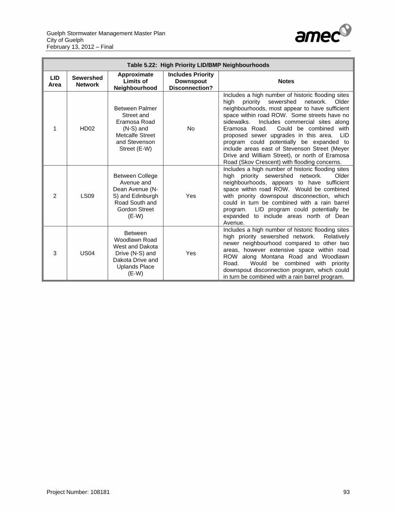
Guelph Stormwater Management Master Plan City of Guelph February 13, 2012 – Final
Project Number: 108181 93
Table 5.22: High Priority LID/BMP Neighbourhoods
LID Area
Sewershed Network
Approximate Limits of
Neighbourhood
Includes Priority Downspout
Disconnection? Notes
1 HD02
Between Palmer Street and
Eramosa Road (N-S) and
Metcalfe Street and Stevenson
Street (E-W)
No
Includes a high number of historic flooding sites high priority sewershed network. Older neighbourhoods, most appear to have sufficient space within road ROW. Some streets have no sidewalks. Includes commercial sites along Eramosa Road. Could be combined with proposed sewer upgrades in this area. LID program could potentially be expanded to include areas east of Stevenson Street (Meyer Drive and William Street), or north of Eramosa Road (Skov Crescent) with flooding concerns.
2 LS09
Between College Avenue and
Dean Avenue (N-S) and Edinburgh Road South and Gordon Street
(E-W)
Yes
Includes a high number of historic flooding sites high priority sewershed network. Older neighbourhoods, appears to have sufficient space within road ROW. Would be combined with priority downspout disconnection, which could in turn be combined with a rain barrel program. LID program could potentially be expanded to include areas north of Dean Avenue.
3 US04
Between Woodlawn Road West and Dakota Drive (N-S) and
Dakota Drive and Uplands Place
(E-W)
Yes
Includes a high number of historic flooding sites high priority sewershed network. Relatively newer neighbourhood compared to other two areas, however extensive space within road ROW along Montana Road and Woodlawn Road. Would be combined with priority downspout disconnection program, which could in turn be combined with a rain barrel program.
Guelph Stormwater Management Master Plan City of Guelph February 13, 2012 – Final
Project Number: 108181 94
6. STORMWATER QUALITY MANAGEMENT ASSESSMENT 6.1 Process A common problem in urban land development relates to the approach to effectively provide stormwater management for small to moderate infill developments and redevelopments (MOE Stormwater Management Planning and Design Manual, 2003). Infill developments and redevelopments generally involve parcels of land less than 5 ha in area, and are usually located in areas with established storm sewer infrastructure. Due to the small areas involved, it is generally difficult or ineffective to implement “traditional” stormwater management techniques (i.e. ponds), whether it be for quantity or quality control. There is also the concern that implementing stormwater management for each new infill development will result in the proliferation of small facilities which will all require excessive maintenance and upkeep, and which may not be economically or environmentally effective. The City of Guelph has undertaken a study, termed the Growth Management Strategy, which identifies strategic locations within the City of Guelph for redevelopment in accordance with the Province’s “Places to Grow Act”. Recognizing that stormwater management for these areas presented a particular issue for the City which would need to be addressed as the redevelopment of these locations proceeded, the Stormwater Management Master Plan has included the development of preferred alternatives for the provision of stormwater quality control for these redevelopment areas. 6.2 Growth Management Strategy City of Guelph Planning staff has provided details regarding the recommended sites for intensification as part of the City’s Growth Management Strategy. The Growth Strategy has projected that the City’s population would increase from 115,000 to 175,000 people by 2031 and the number of jobs would increase by 31,000. As part of the Growth Strategy an infill/ intensification analysis has been conducted that has involved a city wide property evaluation that identified key sites that would be appropriate to facilitate residential intensification. The following has been considered in determining areas for infill and intensification: • Existing vacant land, • Intensification sites which were considered underutilized and • Redevelopment sites that may require rezoning/ re-designation Following testing of identified infill/ intensification sites using various criteria, approximately 18,500 dwelling units within the 2031 Growth Strategy timeframe have been determined within the City of Guelph limits. The infill/ intensification area would be approximately 405 ha (+/-) at an average 89 % impervious coverage, which will all require some form of stormwater quality treatment.
Guelph Stormwater Management Master Plan City of Guelph February 13, 2012 – Final
Project Number: 108181 95
6.3 Stormwater Quality Management Approaches A long list of stormwater quality management approaches has been developed for the City’s redevelopment and intensification areas, based on the MOE guidelines and current standards of practice. The following general alternatives have been considered for stormwater quality management and each has been evaluated based on effectiveness in providing water quality enhancements for the defined re-development and infill areas. Alternative No. 1 – “Do Nothing” Under the “Do Nothing: Alternative, untreated runoff from re-development or infills would be allowed to discharge uncontrolled to the receiving watercourses. This approach would be contrary to current prevailing Provincial guidelines regarding stormwater quality, as the untreated discharge to the water bodies will result in the loss of habitat and destruction to the natural environment. Due to the issues associated with this practice, this alternative has not been advanced for further consideration. Alternative No. 2 – Provide On-site Stormwater Quality Management for Re-development & Infills Traditionally, stormwater management for small areas has been designed for each separate development area, as the development applications and engineering submissions are completed for the individual sites. Approved techniques for the provision of on-site stormwater quality control are provided in the Stormwater Management Practices Planning and Design Manual (MOE, 2003). Various techniques for stormwater quality control include:
• Soakaway pits • Infiltration trenches • Grassed swales • Pervious pipe systems • Pervious catchbasins
• Vegetated filter strips • Buffer strips • Oil/Grit separators • Wet ponds • Wetlands • Hybrids wet pond/wetland system
The application of grassed swales or oil/grit separators is generally the most common BMP for smaller size developments (i.e. less than 5 ha) due to reduced land requirements compared to the other alternatives, as well as their applicability regardless of soil conditions (i.e. infiltration technologies require relatively permeable soil conditions). Of these two options, oil/grit separators are commonly used for commercial/industrial applications where the impervious coverage for the site is relatively high (i.e. greater than 85%) and the site plan is developed such that the maximum developable area is utilized. For larger size developments (i.e. greater than 5 ha), end-of-pipe wet ponds, wetlands, or hybrid facilities are considered appropriate, due to the drainage area limitations associated with other techniques. Increasingly, wet ponds are preferred by municipalities over wetlands as a result of public concerns regarding perceived hazards, associated with shallow waters and West Nile Virus issues.
Guelph Stormwater Management Master Plan City of Guelph February 13, 2012 – Final
Project Number: 108181 96
Under the traditional on-site stormwater management alternative, each parcel of re-development or infill and/or a group of neighbouring development sites, would provide separate stormwater management systems at the source. The facility could be a wetland, wet pond, oil/grit separator (OGS), enhanced grassed swale or combinations, depending upon impervious area and the total drainage area to the facility. The implementation of on-site facilities would provide quality control to Provincial standards, however it is generally costly in terms of capital costs and operations and maintenance requirements by the Municipality, compared to the other alternatives available. On-site quality controls provide benefits by controlling contaminants at the source; however these benefits may be functionally lost due to subsequent discharge to storm sewers and mixing with untreated/contaminated water before outletting to watercourses sustaining habitat. Furthermore, the operation and maintenance of the smaller facilities (i.e. swales, oil/grit separators, and wet facilities for smaller development areas) is generally the responsibility of the owner; thus, under this approach, the Municipality’s approach would be reactive rather than proactive in ensuring that stormwater management controls on private property are operational and functioning as per the designs. For these reasons, this alternative has not been advanced as the preferred alternative for providing stormwater quality control for the City’s intensification zones. Alternative No. 3 – Cash in Lieu of On-Site Stormwater Management The Province has recognized that applying financial contributions (FC), or “cash-in-lieu” requirements to infill developments would limit the number of stormwater facilities being constructed. Monies, which would have been used for stormwater management by individual infill developments, would be directed into larger, more centralized facilities, or for upgrading of existing facilities and/or infrastructure. This approach of “compensating” for the absence of on-site SWM facilities would typically only be applied when the construction and/or installation of such facilities may be ineffective, or impractical, given the physical constraints of the property (MOE Stormwater Management Planning and Design Manual, 2003). Commercial and industrial infill development susceptible to spills would still be required to provide spill prevention and management on-site, such as oil/grit separators.
Various methods for calculating the FC have been proposed (ref. Chapter 5, MOE Stormwater Management Planning and Design Manual, 2003). The method most commonly used is the “Area/Imperviousness Basis” method, which links imperviousness and runoff volumes to the FC through using a generic formula. Although this method considers the water quality parameters of each individual development site, it fails to consider the required funds necessary to provide for water quality measures that would be implemented on a watershed and Municipal basis. By preparing and implementing this Master Plan, the total required FC for the City of Guelph can be determined and then divided proportionally for each development site where implementing “traditional” stormwater management techniques would be considered ineffective. The two fundamental approaches to establishing off-site retrofits, consist of modifications to Existing (or Planned) SWM Facilities and/or treatment provisions at Existing Storm Outfalls.

Guelph Stormwater Management Master Plan City of Guelph February 13, 2012 – Final
Project Number: 108181 97
Existing/Planned SWM Facilities This method of stormwater quality control involves modifying existing stormwater management facilities (quantity or quality control) to provide targeted water quality control. Although this method is primarily intended for existing stormwater facilities, it can also be considered during the planning stages for new quantity facilities, if it is expected that upstream stormwater runoff (i.e. pond outflow) would adversely affect downstream watercourses and habitat through water quality degradation. When possible, retrofitting existing/planned facilities is considered to be a cost-effective approach since land costs (if any) would generally be less than that required for a new facility. Also, the majority of the infrastructure of an existing facility is already in place (headwalls, access paths, berms) and hence would only require modification. A reduction in future maintenance costs could be realized since both quantity and quality control functions have been consolidated into one facility, therefore, the number of facilities requiring maintenance would be reduced. There are four (4) methods generally considered available for the retrofitting of an existing or planned SWM facility: 1. Construct a permanent pool, or in the case of an existing quality facility, deepen or
expand the existing permanent pool 2. Modify the facility to provide for extended detention storage 3. Provide longer, extended, flow paths through the facility to promote settling of
suspended solids 4. Provide additional, or enhanced vegetation within the facility to promote nutrient uptake,
water polishing, and temperature control (shading) In determining the feasibility of retrofitting an existing or planned stormwater management facility, a number of factors must be considered: • Ability to physically enlarge/retrofit a facility. Is land available (i.e. public lands, parks
etc.) adjacent to the facility? Is it possible to implement retrofits within the confines of the existing/planned facility?
• Tributary area draining to the facility • Type of upstream land use • Facility location versus groundwater resources sensitive to infiltrated contaminated
runoff • Sensitivity of downstream (receiving) watercourses and the need for improved
stormwater quality • Cost-benefit of retrofit. Is maximum benefit being realized from monies spent, or should
monies be directed elsewhere to realize greater water quality benefits? The retrofit design approach would be unique for each existing/planned stormwater management facility under consideration. Whenever possible, designs should work toward the “Water Quality Storage Requirements based on Receiving Waters” (MOE Stormwater Management Planning and Design Manual, 2003). However, given that limitations may exist in providing water quality storage volumes in strict compliance with the SWMP Manual, facilities can still be retrofitted to provide some level of stormwater quality control, as this would likely

Guelph Stormwater Management Master Plan City of Guelph February 13, 2012 – Final
Project Number: 108181 98
remain beneficial, subject to an economic review. The “criteria” in such cases when full quality volumes cannot be realized will take the form of runoff volumes expressed in millimetres (mm) of runoff; this would follow the equivalent removal principle. Existing Storm Outfalls Existing storm outfalls provide opportunities to implement online treatment of various upstream land uses within the context of new retrofit facilities typically constructed on existing available public lands. Water quality facilities in the form of wetlands, wet ponds or hybrids would provide both permanent pool and extended detention volumes. Possible sites would be evaluated on factors similar to those listed in the foregoing for retrofit of existing/ planned SWM facilities. Candidate sites for providing stormwater quality control at existing storm outfalls are generally evaluated based upon the following additional criteria:
(i) Land availability, land use flexibility and ownership (ii) Storm outfall location within the available land (iii) Storm outfall tributary drainage area and respective characteristics (iv) Storm outfall location versus sensitive groundwater resources (v) Potential outlet location with respect to receiving waters (vi) Downstream aquatic resource benefit potential and water quality requirements (vii) Financial resource allotment and potential cost/benefit ratio Retrofit Opportunities Recognizing the benefits associated with providing stormwater quality control through the construction of retrofit facilities, Alternative 3 has been advanced for further consideration. Various candidate locations have been identified within the City of Guelph for retrofitting existing storm sewer outfalls and stormwater management facilities in order to provide stormwater quality control, based upon the criteria provided previously. The stormwater quality retrofit assessment has been conducted to determine potential locations throughout the City for retrofitting storm sewer outlets and existing SWM facilities to allow for water quality treatment. Storm sewer outlets have been assessed to determine if an end-of-pipe stormwater management facility could be constructed or an oil/grit separator could be placed at the identified outlet. Existing dry SWM facilities have also been assessed for the potential to be converted to either a wet pond or a wetland. Storm sewer outlet retrofits preliminary designs have been primarily located on City owned lands, although a few facilities could be considered on private lands with input from the City on acquisition feasibility. The storm sewer outlet retrofits preliminary designs are either wet pond or wetlands depending on the land availability and topography. Many potential retrofit locations have been screened from further consideration due to either the lack of land, and/or the existing storm sewer profile and elevations relative to the adjacent watercourse. Storm sewer outlet retrofits have been designed within the available lands to maximize the level of water quality protection provided and to target MOE Level 1 or Enhanced water quality protection for the contributing drainage area.

Guelph Stormwater Management Master Plan City of Guelph February 13, 2012 – Final
Project Number: 108181 99
Existing dry ponds have been reviewed for retrofit potential. Preliminary wet pond or wetland designs within the perimeter of the existing dry ponds have been prepared. Similar to storm sewer outlet retrofits, the land availability within the dry pond limits the level of water quality protection that can be provided by the retrofit. An added complication to retrofitting dry ponds is the existing storm sewer inlet(s) and outlet(s) configuration and elevations. Existing land uses such as parks also have to be considered in some of the preliminary dry pond retrofit designs. A number of ponds have been classified within the City of Guelph Stormwater Management Inventory as dry ponds, but based on site reconnaissance and the photographs from the Inventory the ponds have permanent pools. These dry ponds would require grading and potential outlet reconfiguration to provide quality protection, but as the details of the permanent pool and outlets are not known, treatment capacity areas cannot be determined. Each of these facilities would require additional study and detailed topographic survey to assess the potential treatment area. A number of the recommended retrofit facilities are located in close proximity to the City’s wells. Although the retrofit facilities provide improved surface water protection, potential contamination of the City’s groundwater system and drinking supply is in conflict with improved surface water quality. Hence the location (siting) of potential retrofit facilities must take into account the function of the quantity and quality of existing natural recharge within the groundwater flow system. The existing recharge provides water to the municipal aquifer(s) and maintains the groundwater flow system’s discharge function to surface water features. While maintaining the functional quantity of recharge the quality of potential infiltrating groundwater must be considered for the municipal needs as well as aquatic and terrestrial needs. The City of Guelph Draft Official Plan recognizes these functions and the need to protect them. The Source Water Protection studies have basically identified the majority of the City of Guelph as a Wellhead Protection Area with groundwater travel times less than 5 years. Aquifer Vulnerability mapping has been carried out and can be used to further assess the potential for risk to the municipal aquifer(s) groundwater quality. The current Tier 3 Water Budget and Risk Assessment can provide estimates for the quantity of recharge necessary to maintain the groundwater functions. These groundwater management and risk characterizations would be an integral part in the decision making for the location and design of retrofit facilities. The decision to infiltrate groundwater will depend on the expected contaminant potential within the infiltrating water and the degree of contaminant susceptibility to the local aquifers. As outlined in the Draft Official Plan more detailed site specific studies may have to be carried out to refine the local groundwater characterization and potential impacts and risk. It is expected that various levels of groundwater monitoring will carried out following the construction of the retrofit facilities. The extent of monitoring will depend on the types of potential contaminants, the facility design and the local hydrogeologic sensitivity. In addition to consideration of the City’s drinking water supply, further study of the impacts of each stormwater retrofit site to the NHS will be required in subsequent Municipal Class Environmental Assessments for each site. A number of the proposed retrofit facilities are proposed either within, or adjacent to, the NHS. Retrofit facilities Nos. 3, 6, 8-10 would be located adjacent to locally significant wetlands. Each Class EA would have to provide
Guelph Stormwater Management Master Plan City of Guelph February 13, 2012 – Final
Project Number: 108181 100
discussion on the integration of facilities with the NHS mitigation measures for offsetting NHS impacts. The City of Guelph provides residents with open spaces, trail systems and parks that are designed to meet the needs of communities and the City. Some of the proposed retrofit opportunities are located within parks and open spaces, as such the retrofit’s design for the park should incorporate and enhance the existing park and open space usage. Public and City staff consultation will be required to identify concerns and potential opportunities for improving upon the existing recreational uses, while maximizing the water quality benefit of the retrofit. Retrofits that would be located within existing stormwater management facilities should consider naturalization and trail opportunities. The following list of retrofits outlines where a proposed retrofit would be located either within a community park or open space. Retrofit Site 1: Open space on the south side of Speed River west of Edinburgh Road South Retrofit Site 3: Open space west of Eramosa Road, north of Brant Avenue Retrofit Site 4/ 4a: Open space (Marianne’s Park -176 Gordon Street) located on the south side of Speed River west or east of Gordon Street Retrofit Site 5: Bullfrog Pond Park – 13 Walnut Drive, located east of Stevenson Street North Retrofit Site 7: Skov Park – 580 Eramosa Road, located northwest of Victoria Road North and Eramosa Road intersection Retrofit Site 8: Open space east of Kortright Road East and north of Brady Lane Retrofit Site 9: Open space north of Balfour Court Oil/grit separators (OGS) can be considered at either storm sewer outlets or elsewhere within a storm sewer network to provide MOE Level 2 or Normal water quality protection. Typically OGS provide water quality treatment for small drainage areas such as 2 ha (+/-) when considered as single units. Drainage areas greater than 2 ha can be considered when OGS are placed in series. OGS are considered to be expensive with units costing as much as $30,000 to $100,000 and can have significant maintenance costs due to the frequent cleanout requirements (semi- annual). As such OGS retrofits should be considered carefully and placed at a lower priority compared to other retrofit opportunities. The stormwater quality retrofit assessment is considered to be preliminary and City staff in conjunction with GRCA and other agencies would need to identify which retrofit sites should be advanced for further study in Municipal Class Environmental Assessments (Class EAs). As part of the subsequent Class EAs, preliminary stormwater quality retrofits would have to be reviewed and modified based on potential existing servicing conflicts and social considerations such as park lands, trail use and others. Based on input from GRCA during the Master Plan preparation, stormwater quality retrofits could be located within GRCA’s regulatory limits. Table 6.1 provides a summary of the preliminary stormwater quality retrofits and the level of water quality protection provided, along with preliminary cost estimates. Detailed cost estimates have been included in Appendix ‘L’.

Guelph Stormwater Management Master Plan City of Guelph February 13, 2012 – Final
Project Number: 108181 101
Table 6.1: Preliminary Stormwater Quality Retrofit Opportunities
Priority #
Retrofit Site
Number Drainage Area (ha) Retrofit Type
Approximate Impervious Coverage
(%)
Permanent Pool
Volume (m3)
Extended Detention Volume
(m3)
Treatment Capacity Area (ha)
Cost $
1 2 180.23 Storm Sewer Outlet Retrofit/ 30 12,595 5,013 143.94 $1,240,000
2 6 77.15 Existing Dry Pond Retrofit 65 13,739 3,239 78.86 $1,270,000
3 12 221.54 Storm Sewer Outlet Retrofit 40 7,600 N/A 67.6 $0 1.
4 1 30.74 Storm Sewer Outlet Retrofit 30 951 1,280 28.2 $250,000
5 5 27.87 Existing Dry Pond Retrofit 40 2,504 2,471 22.25 $390,000
6 3 17.64 Storm Sewer Outlet Retrofit 40 796 613 17.22 $290,000
7 8 14.8 Existing Dry Pond Retrofit 40 1,988 673 14.8 $300,000
8 7 29.26 Existing Dry Pond Retrofit 40 1,391 2,065 12.37 $280,000
9 4 14.5 Storm Sewer Outlet Retrofit 40 984 573 8.74 $570,000
10 9 7.56 Existing Dry Pond Retrofit 40 344 281 7.01 $170,000
11 13 3.27 New Oil Grit Separator 95 N/A N/A 3.27 $75,000
12 18 2.4 New Oil Grit Separator 40 N/A N/A 2.4 $50,000
13 19 2.4 New Oil Grit Separator 30 N/A N/A 2.4 $50,000
14 11 2.16 New Oil Grit Separator 65 N/A N/A 2.16 $40,000
15 10 3.45 Existing Dry Pond Retrofit 40 72 55 1.37 $140,000
16 14 20.12 Grading and Outlet Reconfiguration 40 NA NA NA $143,000
17 15 6.66 Grading and Outlet Reconfiguration 40 NA NA NA $80,000
18 16 23.06 Grading and Outlet Reconfiguration 40 NA NA NA $143,000
19 17 5.66 Grading and Outlet Reconfiguration 40 NA NA NA $80,000
TOTALS 690.47 412.59 $5,561,000 1. Costs have been included in the stormwater quantity management facility costing
Drawing 17 (attached) indicates the locations of all 19 sites. Preliminary detailed design drawings for potential retrofit sites 1-10 showing grades have also been included in Appendix ‘L’, along with the associated detailed cost estimates. Low Impact Development (LID) Practices As discussed in Section 5.5, LID practices will be considered for neighbourhood retrofit pilot projects to reduce runoff to existing drainage systems with significant capacity constraints. With respect to water quality and applying LID practices, all urban stormwater runoff is not equal, therefore the application of LID practices has to be considered carefully. Urban runoff water quality can vary depending on land use, age of development and existing stormwater management in place. Roads and/or parking lots have vehicular traffic and receive salt and sand during winter months. Roofs on the other hand typically produce relatively “clean “runoff, which can be directed to LID infiltration practices without pretreatment. Relatively clean runoff should be prevented from mixing with reduced quality runoff, making infiltration impractical.
Guelph Stormwater Management Master Plan City of Guelph February 13, 2012 – Final
Project Number: 108181 102
6.4 Nutrient Offset Program Feasibility Nutrient offset programs are relatively new in Canada, however have been applied in the United States for some time. In essence, the objective of these programs is to meet instream nutrient targets in designated waterways by way of a combination of stormwater management and enhanced wastewater treatments. The water quality or nutrient trading concept uses economic instruments to help manage environmental impacts within a watershed with the general goal of a net reduction of pollutants, such as phosphorus. Water quality trading can be a tool to reduce nutrient loadings in a cost-effective and strategic manner by collectively engaging key stakeholders. It has been argued that water quality trading provides an incentive for non-point source contributors to become more actively involved in implementing best management approaches to reduce phosphorus loadings. The City of Guelph currently has approximately 112 + stormwater management facilities and the Waste Water Treatment Plant which manage a portion of the phosphorus or nutrient loadings to the Speed River and its tributaries. Other mechanisms for removing nutrients include City owned oil/grit chambers and other best management practices such as informal water quality treatment from grass swales, vegetative filtering and buffer strips. Included in this Master Plan are recommendations for stormwater quality retrofits and impervious cover disconnections and removal, which assist in reducing nutrients (phosphorous) from the Speed River and its Tributaries. The foregoing nutrient reduction measures would have to be included in a Nutrient Reduction Strategy and Offset Program which is able to provide nutrient loading targets and financial incentives for reducing nutrient loadings. Such a Strategy does not currently exist for the Grand River (which the Speed River is a tributary of), however there is a similar strategy for the Lake Simcoe watershed. The Lake Simcoe Protection Act, passed in Ontario in 2008, formed the basis for the Lake Simcoe Protection Plan. The Lake Simcoe Protection Plan, June 2009, outlines a number of recommendations to protect and restore the ecological health of the Lake Simcoe watershed. The Plan includes recommendations for improving water quality by reducing phosphorus loadings into the Lake. The Lake Simcoe Protection Plan provides the steps necessary to reach a Phosphorus loading target, with water quality trading as one of many tools to be used to help reduce phosphorus loads. A Draft Phosphorus Reduction Strategy and associated amendments to the Lake Simcoe Protection Plan (is available at www.ebr.gov.on.ca, registry number 010-8986). A feasibility study for the Lake Simcoe Protection Plan was conducted in 2010, and outlined potential guiding principles that could be used to set the foundation for developing, implementing, and evaluating the success of a water quality trading program. The study suggests that a water quality trading program should be accountable, defensible, economical, enforceable, equitable and transparent. For the water quality trading program to be implemented, it was noted that there would need to be both “buyers” and “sellers” of phosphorus reduction credits. A list of ‘buyers”, “sellers” and participants from the Feasibility Study included:
Guelph Stormwater Management Master Plan City of Guelph February 13, 2012 – Final
Project Number: 108181 103
Potential Buyers: Municipal sewage treatment plants New urban stormwater dischargers
Potential sellers: Stormwater retrofits in areas of existing development Best management practices on agricultural lands Treatment of Holland Marsh polder Conversion of on-site sewage systems Reduction of airborne phosphorus loading
Other potential participants: Landowners Industrial dischargers First Nations and Métis communities Conservation Authority Non-governmental organizations Capital investors
The 2010 Feasibility Study for Lake Simcoe recommended using either a “clearinghouse” or an exchange market trading structure for phosphorus where a selected administrator or exchange has the responsibility for managing the phosphorous trading. The phosphorous trading administration and governance would either be a coalition of existing agencies and/or associations or by an existing watershed organization, all subject to regulatory oversight by the province. Factors to be considered as part of the phosphorous trading program included the following: • Sources of phosphorus and variable loadings • The ability to collect, evaluate, and verify information related to both the generation of
phosphorus reduction credits and the effectiveness of the water quality trading program as a whole;
• Funding of administrative costs • Public engagement in developing, implementing, and evaluating the success of a water
quality trading program As evident from the Lake Simcoe Protection Plan, there are a number of prerequisites required before a Nutrient Offset Program can be implemented and considered successful. For the City of Guelph to consider a Nutrient Offset Program discussion with GRCA and the Province would be required, as the Program has to be enforceable, as a minimum. To manage a Nutrient Offset Program there would also need to be tools that are capable of assessing nutrient loadings from both point sources and non-point sources. The GRCA’s Grand River Simulation Model may be able to provide the basis for this information. The Grand River Simulation Model (GRSM) is a computer model of the watershed used by water quality and planning staff to understand how any proposed changes in the watershed might impact the quality of water in the Grand River watershed. The Grand River Simulation Model (GRSM) is an in-stream water quality model that simulates nutrient and dissolved oxygen
Guelph Stormwater Management Master Plan City of Guelph February 13, 2012 – Final
Project Number: 108181 104
processes in the central portion of the Grand River watershed. The model determines nutrient enrichment, resulting from various inputs including point sources, such as wastewater treatment plants and non-point sources such as agricultural and urban runoff. The GRSM simulates the nutrient loadings and the of processes of nutrient uptake within the Grand River and the subsequent impact on dissolved oxygen, Biochemical Oxygen Demand (BOD), total phosphorus, nitrate, Total Kjeldahl nitrogen, and un-ionized ammonia concentrations. The model covers 164 km of the Grand River from the Shand Dam to the Six Nations Drinking Water Intake at Ohsweken and 33 km of the Speed River from Guelph Lake to its confluence with the Grand River. In addition the GRSM incorporates water quality data from the Guelph Wastewater Treatment Plant (among others) and data on river flows, temperatures and dissolved oxygen levels. It should be noted that the GRCA continuously monitors dissolved oxygen and temperatures at seven (7) water quality monitoring stations in the watershed, which can be used for calibration of the GRSM model. Based on the foregoing it is considered that an adequate tool exists that could be used as part of a Nutrient Offset Program to form the technical basis for this assessment. For a program to be feasible it would require a regulatory body to administrate and enforce the Offset Program and track nutrient loadings and credits. The administrator in the Guelph setting could be GRCA with assistance from the major municipal bodies such as Guelph as partners. Projects would have to be recommended that result in nutrient reductions such as stormwater management facilities, retrofits, improvements to the City of Guelph’s WWTP, improved riparian buffers to name a few. In addition GRCA’s monitoring plan would need to continue or be expanded to accurately determine the impacts of various non-point nutrient sources and the benefits of reduction measures. On the basis of the outline offered in the foregoing summary of requirements and criteria for a Nutrient Offset Program, it is considered that several of the important and fundamental components of such a program are present and available in the Grand River (Speed River) watershed in the Guelph area. As such, it is suggested that such a program would be feasible and should be pursued. 6.5 Total Mass Loading Monitoring Program A Total Mass Loading (TML) model and assessment approach in addition to a surface water quality monitoring program is to be developed to characterize existing water quality within the City as part of this study. Various modelling platforms are available to assess surface water quality such as the following: • Continuous water quality modelling (PCSWMM, HSP-F, CANWET, SIMPTM) • Model-based generated annual runoff volumes used with literature based Event Mean
Concentrations for annual loadings • Mass Balance Spreadsheet Approach Most continuous based water quality modelling require significant amounts of data for modelling set-up and calibration and typically result in a complex modelling exercise to determine surface water quality results. The Mass balance spreadsheet approach uses a simplified approach for
Guelph Stormwater Management Master Plan City of Guelph February 13, 2012 – Final
Project Number: 108181 105
runoff volume estimation and literature values for EMCs based on different land uses. A more accurate method of evaluating the annual runoff would be to use a modelled generated annual runoff volume. The literature based EMCs would have to be verified and refined based on water quality monitoring results. Using modelled annual runoff volumes and refined literature based EMCs would provide an enhanced but simplified approach to determining annual TMLs offering reasonable water quality loading results. Key attributes of the continuous models considered for water quality assessment have been summarized by way of excerpts in Appendix ‘N’. The water quality monitoring program specific to the City of Guelph would have to consider existing monitoring that has been conducted by GRCA and the Province. The Province has 4 non-continuous water quality monitoring sites located upstream of the Guelph urban area on the Eramosa River and Speed River, within the City just downstream of the Eramosa and Speed Rivers confluence and downstream of the City on the Speed River. The Province takes 9 to 10 water quality samples each year at each site. GRCA’s continuous water quality monitoring sites are located throughout the Grand River Watershed with only one site for Guelph located downstream of the WWTP. Based on a limited number and location of existing continuous water quality sites, additional monitoring is considered required; as a minimum, continuous monitoring should be conducted upstream of the City to determine the impact of the municipal urban uses on water quality within the Speed River. It would also be useful to have continuous water quality site downstream of the Eramosa and Speed River confluence. The specific sites for the water quality program would have to be defined in consultation with the GRCA and the Province. Premised on a continuous water quality monitoring approach the number of parameters would have to be limited. GRCA currently measures DO, pH, Temperature and Conductivity. The potential to continuously monitor Turbidity as a surrogate for TSS should be examined, as this parameter can provide a reasonable basis of determining contaminant loadings from urban runoff. Monitoring for other parameters (due to analysis costs) would have to be done using semi-continuous or grab sampling techniques for dry and wet weather events, which would assist in determining contaminant loadings for various wet weather events. The text which follows offers some of the considerations for water temperature and water chemistry monitoring which should be considered when developing a Total Mass Loading (TML) Monitoring Program. 6.5.1. Water Temperature Purpose Appropriate water temperature is critical for the survival of aquatic organisms. High water temperatures which could result from latent heating of stormwater (either due to urbanization or retention in surface water ponds), can adversely affect the health and survival of fish and other aquatic organisms, particularly in cold water streams.
Guelph Stormwater Management Master Plan City of Guelph February 13, 2012 – Final
Project Number: 108181 106
Methodology Water temperature is a concern for the stormwater facilities which drain into watercourses. Continuous temperature recorders should be installed from June 1 to September 30 at the outlet from facilities, both upstream and downstream of the facility outlets, to monitor the effectiveness of measures to cool the effluent and the impact on stream temperature. 6.5.2. Water Chemistry Purpose One of the intended functions of stormwater management facilities is the removal of urban contaminants from storm runoff. The end-of-pipe measures (wetlands or wet ponds) have typically been designed as Enhanced (formerly) Level 1 water quality facilities. The purpose of the monitoring is to ensure that the facilities’ function as designed and if not offer some level of insight into the need for performance improvement measures. Methodology Chemical sampling of instream stormwater is highly variable and difficult to establish statistical accuracy within a limited budget. Hence, often grab samples are collected from the inlet and outlet of each stormwater management facility after construction. Each site should have a minimum of 3 events sampled per year, typically representative of an average spring, summer and fall event (rainfall event volumes of over 15 mm depth are preferable). Each facility should be monitored for a minimum of 5 years. The parameters to sample for includes: • Oil and Grease • Total Phosphorus • Anions (Nitrate, Nitrite, Phosphate, Chloride) • Ammonia • Total Kjeldahl Nitrogen (TKN) • Conductivity • Total Solids (TS) • Total Suspended Solids (TSS) • BOD5 • Dissolved Oxygen • pH/alkalinity • Total Coliforms • Faecal Coliforms • PAH • Metals (Al, Sb, As, Ba, Be, B, Cd, Ca, Cr, Co, Cu, Fe, Pb, Mg, Mn, Mo, Ni, P, K, Se, Si, Ag, Na,
Sr, Tl, Sn, Ti, W, U, V, Zn, Zr).
Guelph Stormwater Management Master Plan City of Guelph February 13, 2012 – Final
Project Number: 108181 107
7. IMPLEMENTATION 7.1 Summary of Recommendations 7.1.1 Minor System 1. The City of Guelph’s storm sewer system has been assessed using the PCSWMM
hydrologic/hydraulic modelling platform. The recommendations for the storm sewer system upgrades are based on the performance assessment using the PCSWMM modelling and as such detail design of the storm sewer upgrades should be refined using the PCSWMM model, with the appropriate refinements as necessary.
2. The PCSWMM hydrologic/hydraulic models developed as part of this Stormwater
Management Master Plan should incorporate new greenfield development and infill / intensification development as it comes on-line to determine if the receiving storm sewer systems have sufficient capacity and/or the new trunk systems can accommodate the new flows. The storage volumes and unitary rates developed in Section 5.4 can be used as a guide in order to avoid increasing discharges to the storm sewer system.
3. The “Top 25” storm sewer system upgrade recommendations should be addressed in
accordance with the prioritization provided in Table 5.17 at an estimated cost of $15,760,000. Implementation timing will need to consider other Municipal infrastructure priorities, as well as available funding.
4. The City of Guelph should conduct the remaining storm sewer upgrades with an
estimated cost of $47,850,000 based on the Drainage Network prioritization procedure provided within Table 5.16, with due consideration of other City capital projects to optimize available resources.
5. A mandatory rooftop downspout disconnection program for Drainage Networks US03-5, LS05, LS06, LS09 and HD02 should be implemented to support the storm sewer upgrade recommendations. These are the highest priority areas. Specific neighbourhood areas targeted for priority downspout disconnection are shown in Drawing 15. The total estimated implementation cost for these areas is $627,000, not including administrative costs or any costs associated with an educational program. Other areas of the City should also be disconnected as funding becomes available. LID and BMP measures are also recommended for consideration in targeted locations, as shown in Drawing 15. Neighbourhood-scale LID pilot programs are recommended for these areas. It is recommended that an educational program be developed in conjunction with all of these programs, particularly the downspout disconnection program, in order to educate the public on its benefits. Associated programs, such as a rain barrel program, could also be developed. Incentives beyond the assumed subsidy (such as a Stormwater Rate, as discussed in Section 7.5) may also be required to ensure adequate participation.
6. Opportunities to address major system flow capacity constraints such as sags should be incorporated within the detail design of local storm sewer upgrades (ref. Section 7.1.2).

Guelph Stormwater Management Master Plan City of Guelph February 13, 2012 – Final
Project Number: 108181 108
7. Additional Rainfall and Flow monitoring should be considered to improve the accuracy of
hydrologic/hydraulic modelling and thereby refine sizing for subsurface infrastructure. The use of radar rainfall data in this regard would also be useful to account for the high spatial and temporal variability of rainfall events.
8. Rainfall monitoring should also continue to support future IDF updates and for use in other stormwater management and subwatershed studies.
9. The recommendations herein do not necessarily address cases of basement flooding, as there are numerous potential causes beyond limited storm sewer capacity. Measures to limit basement flooding (such as weeping tile disconnection and backflow preventers) should be considered as part of a review of City of Guelph’s design standards and policies. Sanitary sewer improvements should also be considered in conjunction with the recommended storm sewer upgrades in areas prone to basement flooding (and where foundation drains and floor drains are connected in to the sanitary system).
10. The large number of storm sewers located on private property (ref. Drawing 8) is a concern, both from an access and maintenance point of view. While the proposed drainage system upgrades outlined herein have attempted to bypass or eliminate these sewers where possible, a more detailed strategy to remove these sewers or bring them into public control should be developed as part of a larger policy review.
11. The drainage network modelling should be reviewed prior to detailed design to determine the need for more discrete and resolute hydrologic/hydraulic modelling to address potential drainage network deficiencies at the sub-trunk level.
7.1.2 Major System 12. Roadway capital projects should investigate opportunities to address overland flow
deficiencies within the City’s road right-of-ways based upon the performance metrics detailed within this report.
13. The City should continue to monitor and track sites of reported surface and subsurface
flooding and co-ordinate with other Municipal departments and agencies as required for the tracking and monitoring of these conditions.
7.1.3 Stormwater Quantity Management Stormwater quantity controls have been proposed in addition to storm sewer upgrade to reduce the 5 year storm peak flows within the drainage system and to reduce the magnitude of required storm sewer upgrades. Table 7.1 provides a summary of the stormwater facilities considered necessary to minimize storm sewer upgrades based on the available land for facilities.
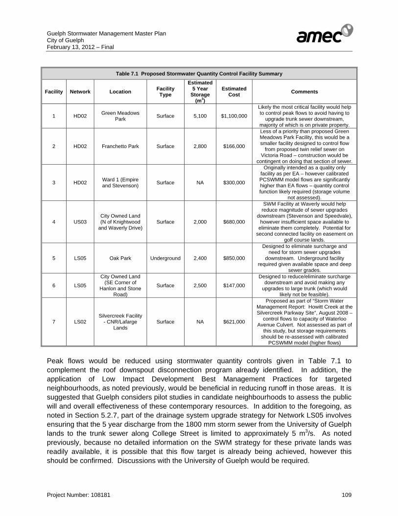
Guelph Stormwater Management Master Plan City of Guelph February 13, 2012 – Final
Project Number: 108181 109
Table 7.1 Proposed Stormwater Quantity Control Facility Summary
Facility Network Location Facility Type
Estimated 5 Year
Storage (m3)
Estimated Cost Comments
1 HD02 Green Meadows Park Surface 5,100 $1,100,000
Likely the most critical facility would help to control peak flows to avoid having to
upgrade trunk sewer downstream, majority of which is on private property.
2 HD02 Franchetto Park Surface 2,800 $166,000
Less of a priority than proposed Green Meadows Park Facility, this would be a smaller facility designed to control flow
from proposed twin relief sewer on Victoria Road – construction would be
contingent on doing that section of sewer.
3 HD02 Ward 1 (Empire and Stevenson) Surface NA $300,000
Originally intended as a quality only facility as per EA – however calibrated PCSWMM model flows are significantly higher than EA flows – quantity control function likely required (storage volume
not assessed).
4 US03 City Owned Land (N of Knightwood
and Waverly Drive) Surface 2,000 $680,000
SWM Facility at Waverly would help reduce magnitude of sewer upgrades
downstream (Stevenson and Speedvale), however insufficient space available to
eliminate them completely. Potential for second connected facility on easement on
golf course lands.
5 LS05 Oak Park Underground 2,400 $850,000
Designed to eliminate surcharge and need for storm sewer upgrades
downstream. Underground facility required given available space and deep
sewer grades.
6 LS05
City Owned Land (SE Corner of
Hanlon and Stone Road)
Surface 2,500 $147,000
Designed to reduce/eliminate surcharge downstream and avoid making any
upgrades to large trunk (which would likely not be feasible).
7 LS02 Silvercreek Facility
- CNR/Lafarge Lands
Surface NA $621,000
Proposed as part of “Storm Water Management Report: Howitt Creek at the Silvercreek Parkway Site”, August 2008 –
control flows to capacity of Waterloo Avenue Culvert. Not assessed as part of
this study, but storage requirements should be re-assessed with calibrated
PCSWMM model (higher flows)
Peak flows would be reduced using stormwater quantity controls given in Table 7.1 to complement the roof downspout disconnection program already identified. In addition, the application of Low Impact Development Best Management Practices for targeted neighbourhoods, as noted previously, would be beneficial in reducing runoff in those areas. It is suggested that Guelph considers pilot studies in candidate neighbourhoods to assess the public will and overall effectiveness of these contemporary resources. In addition to the foregoing, as noted in Section 5.2.7, part of the drainage system upgrade strategy for Network LS05 involves ensuring that the 5 year discharge from the 1800 mm storm sewer from the University of Guelph lands to the trunk sewer along College Street is limited to approximately 5 m3/s. As noted previously, because no detailed information on the SWM strategy for these private lands was readily available, it is possible that this flow target is already being achieved, however this should be confirmed. Discussions with the University of Guelph would be required.
Guelph Stormwater Management Master Plan City of Guelph February 13, 2012 – Final
Project Number: 108181 110
7.1.4 Stormwater Quality Management The infill/ intensification assessment related to the City’s Growth Management Strategy has identified 19 potential locations for stormwater quality retrofits (ref. Table 6.1). The City should initiate a stormwater quality management retrofit program in order to provide stormwater quality control for future infill and redevelopment areas within the City of Guelph. For the stormwater quality management retrofits that are not oil/grit chambers, the City of Guelph should conduct Municipal Class Environmental Assessments that fully assess all aspects of implementing each potential retrofit. The stormwater quality management retrofits should be implemented in a phased manner, concurrent with the timing and phasing of redevelopment and infill development within the City. Notwithstanding, due to the likelihood for a time lag between development and construction of the retrofit, it is recommended that the assessment work be initiated well in advance of development. Stormwater quality control for future infill and redevelopment areas should be implemented under a cash-in-lieu of on-site stormwater management program. As such, a funding program should be established for the implementation of the stormwater quality retrofit program to support future infill and redevelopment areas by way of an area-specific Development Charge for the Infill/ Intensification land base. 7.2 Process 7.2.1 Class Environmental Assessments This Stormwater Management Master Plan has satisfied the Phase 1 and Phase 2 requirements of the Municipal Engineers Association Class Environmental Assessment process (2000, as amended October 2007). The implementation of the recommendations advanced in this study should, where the work constitutes a Schedule B undertaking, proceed to a Notice of Completion. All other recommendations would be a Schedule A or A+ undertaking and as such are considered to be “pre-approved”. The following summarizes the Class EA process required for the recommendations covered under this Stormwater Management Master Plan.
Project Description Class EA Process Annual Maintenance of SWM Facilities
Schedule A
Storm Sewer Upgrade or Replacement
Schedule A or A+
Construction of Retrofits for Stormwater Quality Schedule B Construction of Stormwater Quantity Control Facilities Schedule B Downspout Disconnection Program Bylaw Requirement Neighbourhood LID BMP Retrofitting Schedule B

Guelph Stormwater Management Master Plan City of Guelph February 13, 2012 – Final
Project Number: 108181 111
7.2.2 Development Led Projects Development led projects (typically related to the construction of new residential, commercial or industrial lands) will continue to be required to follow the current City of Guelph stormwater policies and criteria and watershed recommendations, as required. All new development projects should be integrated into the PCSWMM modelling and assessed accordingly. 7.3 Operations and Maintenance Stormwater Management: The City of Guelph currently conducts an operations and maintenance program for stormwater management infrastructure, as recommended by the 2008 Stormwater Management Facility Inventory, Assessment and Maintenance Needs Plan. The 2008 report outlines maintenance and inspection requirements for all end-of-pipe stormwater management facilities with a schedule of maintenance activities from 2009 to 2019. Annual maintenance costs for the 112 + stormwater management facilities have been determined to range from $132,000 to $447,000 with an average annual cost of $266,000. The City of Guelph 2011 Budget for stormwater management inspection on an average annual basis for years 2011 to 2015 is projected to be $115,000, $151,000 short of the recommended $266,000 average annual cost. The stormwater management facility annual maintenance cost does not include the City-owned oil/grit chambers of which there are approximately 140. For each oil/grit chamber, the City should conduct annual inlet and outlet inspection and sediment depth measurements. The frequency of oil/grit chamber cleanout varies, depending on the chamber design and contributing drainage area characteristics. Annual costs for maintaining oil/grit chambers can vary considerably based on the sediment material disposal fees and frequency of cleanout. Based on an average bi-annual cleanout and inspection, maintenance costs for each oil/grit chamber would be approximately $1,250 to $2,500, resulting in an annual maintenance cost for the 140 oil/grit chambers of $175,000 to $350,000 (+/-). Currently the City has a dedicated budget for oil/grit chamber maintenance of $43,000 which, based on the estimated annual maintenance costs, is approximately $132,000 to $307,000 short of budget. Storm Sewer System: Based on the City of Guelph’s drainage infrastructure database there are 5,870 individual storm sewer lengths, at a total length of 344,330 m (344.3 km). There are also 6,729 maintenance chambers and 11,641 catchbasins in the database. The City of Guelph’s storm sewer system requires regular maintenance such as inspection, catchbasin cleaning, storm sewer flushing, video and/or Zoom camera inspection and repair/ replacement of storm sewers not meeting condition requirements. In order to allow for these activities, an allowance of $631,000.00 per annum is recommended to be incorporated into the City’s current storm infrastructure budget. The allowance has been based on a cost of $3.00/m for storm sewer video inspection implemented over a 5 year rotation, $150.00/catchbasin for cleanout over 5 years, and $75,000/annum for sewer flushing on an as-needed basis.
Guelph Stormwater Management Master Plan City of Guelph February 13, 2012 – Final
Project Number: 108181 112
The City of Guelph’s 2011 average annual budget for storm sewer maintenance, which does not include replacement, is $16,000 based on $80,000 total in the Roadside Operations stormwater capital maintenance budget for the period of 2011 to end of 2015. In addition, the City budget has just under $50,000 per year for miscellaneous drainage improvements. The City’s average annual storm sewer replacement budget is $1,004,000 based on $5,020,000 designated for the period of 2011-2015. The recommended storm sewer upgrades, quantity control facilities and roof downspout disconnection program have been estimated to be $63,610,000. Based on implementing the Master Plan recommendations over a 25 year period, the annual budget would need to be approximately $2,544,000, or about two and half times more than current funding levels. Maintenance for sections of storm sewer located on private property (Drawing 8), particularly major trunks, should be considered for a more frequent maintenance and inspection schedule. These additional costs have not been directly considered herein. Total Maintenance Costs: Based upon the foregoing estimated maintenance activities, the following annual total maintenance costs have been advanced for consideration for the City’s stormwater management infrastructure Stormwater Management Facilities: $266,000. Oil/grit Chambers: $175,000 to $350,000 Storm Sewer System Operation $631,000 Storm Sewer Replacement $2,544,000 Total: $3,616,000 to $3,791,000 per year The combined City budget for stormwater management maintenance and storm sewer replacement is currently $1,237,000 which is $2,379,000 less than determined above. 7.4 City Stormwater Monitoring Protocols A City-wide monitoring program is to be established to determine the success of stormwater management and the impact of development on water quality and related environmental measures. Monitoring plans are intended to provide a mechanism for gathering field data for the purpose of assessing system performance against a set of targets and objectives to be established through consultation with all stakeholders such as GRCA and then using this information as guidance for adapting environmental control management systems and improving local environmental conditions. Historically, stormwater monitoring plans throughout the province have had issues with scope and implementation. Monitoring plans have in the past collected significant unusable data, as the monitoring scope has often been improperly defined. In addition, monitoring program scales have often been too broad resulting in too little usable data from many monitoring locations. Different levels of government have not collaborated sufficiently in the development and implementation of monitoring programs which has tended to reduce the success of these

Guelph Stormwater Management Master Plan City of Guelph February 13, 2012 – Final
Project Number: 108181 113
programs. As funding for monitoring programs is limited, improved government agency and stakeholder collaboration and monitoring program coordination would direct funding to appropriate programs and use funding more efficiently. The following questions have been considered in developing the initial monitoring program framework. Water Resources: Surface Water Quantity
• Are the operating conditions of the proposed stormwater quantity management facilities
(i.e. the observed storm events) consistent with the design conditions and reducing flooding or surcharge conditions (i.e. the historic meteorological dataset)?
• What benefit would downspout disconnection and LID practices afford by way of reductions to surface runoff volume and thus reduced flooding and surcharging?
Surface Water Quality
• Are the contaminant loadings (concentrations) from the stormwater quality retrofits consistent with anticipated conditions for the given land use?
• What benefit to stormwater quality control are the LID practices providing?
• What are the current contaminants loadings within each of the watercourse systems and the contributions from sources within the City and external and the effect of stormwater quality management?
Fisheries: • How does the fish community structure, fish abundance, fish habitat and fish productive
capacity change over time based on contributing sources of contaminants?
• Has the Hilsenhoff Biotic Index in reaches that are permanently flowing change as a result of greenfield, infill and intensification development?
Stream Morphology: • How are channel form, bank erosion and bed composition impacted over time by the
urban development within the City of Guelph?
Terrestrial: • Have restoration efforts at stormwater management areas been successful? If not, what
problems or deficiencies have been identified and in what locations?
The following framework outlines the various components of an integrated monitoring program for the City of Guelph. Based on the spatial scale required for monitoring and the number of watercourses within the City, the various monitoring component elements have been organized by category.
Guelph Stormwater Management Master Plan City of Guelph February 13, 2012 – Final
Project Number: 108181 114
A. WATER Quantity a) Rainfall: The City should continue to collect rainfall data to be used in conjunction with
water quality monitoring and for continuous modelling application in the PC-SWMM drainage network models. Based on the area of the City consideration for at least 2 (two) rainfall gauges should be given.
b) Stormwater Quantity Controls/LID/ Downspout Disconnection: Continuous flow
measurement within the receiving minor drainage systems should be conducted prior to and subsequent to the implementation stormwater quantity controls, LID or Downspout Disconnection Program completion. Flow measurements would determine the degree of peak flow reduction for implemented stormwater quantity controls. For LID and Downspout Disconnection the runoff volume reduction would be assessed.
Quality a) Water Chemistry: Water quality monitoring should be conducted at each stormwater
quality retrofit for a minimum of 3 years to determine the performance of the facility. Instream water quality monitoring within the City’s watercourses should be conducted in conjunction with GRCA’s monitoring program and other on-going water quality programs required due to development approval conditions. Monitoring locations should consider external drainage areas to the City and should attempt to isolate the loadings contributions from the City urban land uses. Monitoring should be conducted to obtain an understanding of the contaminant loadings for the various land uses within the City of Guelph. It is anticipated that at least 7 to 8 instream locations should be monitored on an annual basis with 5 wet and dry samples per year. Both stormwater quality retrofits and instream water quality monitoring should consider the following parameters:
• Oil and Grease • Total Phosphorus • Dissolved Phosphorus • Anions (Nitrate, Nitrite, Phosphate, Chloride) • Ammonia • Total Kjeldahl Nitrogen (TKN) • Conductivity • Total Solids (TS) • Total Suspended Solids (TSS) • BOD5 • Dissolved Oxygen • pH/alkalinity • Chloride • E.coli • PAH • Metals (Al, Sb, As, Ba, Be, B, Cd, Ca, Cr, Co, Cu, Fe, Pb, Mg, Mn, Mo, Ni, P, K, Se,
Si, Ag, Na, Sr, Tl, Sn, Ti, W, U, V, Zn, Zr).
Guelph Stormwater Management Master Plan City of Guelph February 13, 2012 – Final
Project Number: 108181 115
b) Temperature: Temperature monitoring should also be conducted within receiving streams both upstream and downstream of effluent discharge points to determine potential cumulative effects of urban runoff and multiple stormwater management facilities. Temperature monitoring sites should coexist with the water quality monitoring sites. Benthics and Fish and Fish Habitat: Urban development and the subsequent increases in percent impervious cover have been found to affect benthic communities, typically trending towards generalist species (those tolerant to ecosystem change) at the exclusion of specialist species (taxa dependant on a stable environment). Urban development also impacts fisheries. As such some of the water quality monitoring stations should be considered for benthics and fisheries monitoring.
B. STREAM SYSTEM a) Stream bank and bed erosion: Stations for monitoring stream bank and bed erosion
should be established at sites where continuous flow data would be available and where it is known that channel is not dynamically stable. Annual erosion rates and associated critical flows could be determined, leading to an understanding of channel stability and identification of mitigation techniques.
b) Channel Form: Channel form can be of several categories such as natural, natural and altered, lined and meandering, lined and straightened. The monitoring program should annual update the channel forms for all watercourses within the City of Guelph.
c) Streamflow: Continuous depth measurements could be used to determine flow at the water quality monitoring locations. Having streamflow and water quality combined would facilitate the determination of contaminant loadings for single storm events.
C. TERRESTRIAL
a) NHS restoration area monitoring: Determining the success of stormwater
management NHS restoration would have to be done on an annual basis for a minimum of 2 (two) years subsequent to plantings. It should be noted here that improvement of riparian plantings adjacent to stormwater management facilities assists in reducing surface water temperatures.
7.5 Funding Sources for Stormwater Management Projects As evident from the set of recommendations related to this Master Plan, the City of Guelph has a significant number of projects to undertake based on the need to improve the current level of service determined through the storm sewer and overland drainage system assessment. The funding for proposed drainage system upgrades could come from various sources as per the following:
Guelph Stormwater Management Master Plan City of Guelph February 13, 2012 – Final
Project Number: 108181 116
General tax base: The City's tax levy is used in part to support the City's stormwater services on an annual basis. The most common municipal funding practice for maintaining municipal stormwater management infrastructure not related to proposed development is property taxes. Property taxes are established based upon the value of private properties and the services provided, and may be adjusted over time based upon changing property values and operating costs by the Municipality. Development Charges: Development Charges is funding based on percentage levied from all new developments for new services. Development Charges are assigned to new developments, based upon the anticipated costs to implement (and maintain) the requisite infrastructure to support the new development. Development Charges are obtained at the time of development implementation to cover the cost of the required new infrastructure, hence it is not considered a viable source of revenue to support the maintenance of existing infrastructure implemented prior to the development. Stormwater User Pay Rates: Stormwater User Pay Rates are charged to users for runoff discharged from their property based on land use classification, property size, estimated impervious area and the intensity of runoff contribution to the City's stormwater management system infrastructure. Recently, Stormwater User Pay Rates (also referred to as Stormwater Utility Fees) have been implemented across the United States and have become an increasingly popular source of dedicated stormwater funding. Similar programs have been initiated in various Municipalities within Ontario such as Waterloo, London, Kitchener, Hamilton, Richmond Hill, St Thomas and Aurora. Stormwater User Pay Rates or Stormwater Utility Fees within the United States are incorporated within State Legislation, and are typically based on some measure of a property’s contribution to stormwater runoff. The general standard applied to utility fees is that the rate methodology must be fair and reasonable, and resultant charges must bear a substantial relationship to the cost of providing services. However, the local government has a great deal of flexibility in attaining these objectives in the context of local circumstances. When Stormwater User Pay Rates have been subjected to legal challenges, the courts have tended to apply “judicial deference” to the decisions of locally elected officials. Under judicial deference, the courts will not intervene unless a plaintiff can demonstrate that the decision was arrived at arbitrarily and capriciously or that the result of the decision discriminates illegally. Stormwater User Pay Rates typically provide more stable revenue than other funding options, offer the opportunity to design a service fee rate methodology that results in an equitable allocation of the cost of services and facilities, and, in some cases, can provide an opportunity to shift a portion of the community’s stormwater management costs away from the General Fund. Service User Pay Rate structures are designed to recover costs based on the demands place on the stormwater systems and programs.

Guelph Stormwater Management Master Plan City of Guelph February 13, 2012 – Final
Project Number: 108181 117
The revenue generation capacity of a Stormwater User Pay Rate or Stormwater Utility Fee is similar to that of the real property tax, except that the utility fee is directly linked to the impervious surface cover or another measurable characteristic, rather than assessed value. Determining a legally defensible rate needed to generate revenue sufficient to finance the local stormwater needs would require the local government to engage in a “Stormwater Utility Rate Study”. During such a study, important policy decisions are made that can have significant implications for the selected rate. An important first step in the process is to determine the average impervious land cover in square metres for a single family residential lot. Although it is common for all single family lots to be charged a flat fee, the Equivalent Residential Unit (ERU) can be applied to all other classifications of land. In addition to technical determinations, local governments must address a range of policy questions that ultimately impact the structure of the utility, as well as the stormwater utility rate. Grant Opportunities: Funding from upper level governments can sometimes be available to help offset the cost of stormwater management infrastructure improvements. Examples of government grant programs are the Province’s Municipal Infrastructure Investment Initiative (MIII) through Infrastructure Ontario, Infrastructure Stimulus Fund (ISF) program, and the City’s Downtown Community Improvement Plan. Funding Combinations: The City of Guelph will face significant costs to implement the drainage system upgrades recommended herein. The existing general tax levy used by the City to establish the current budget allocation for stormwater management infrastructure would, based on the current assessment, not be sufficient. As such, the City of Guelph should consider the assessment of other funding opportunities to implement the requirements determined through this Stormwater Management Master Plan. As such, it is recommended that the City of Guelph initiate a study to investigate alternative funding mechanisms including the potential for a Stormwater user pay Rate or Utility Fee. 7.6 Stormwater Management Design Standards and Policy Review The City of Guelph Design Principles for Stormwater Management 1996 and the Standards of Design for Subdivision Engineering, Sewers, Roads and Watermains, August 1974 provide the requirements for stormwater management infrastructure within the City of Guelph. Both documents despite their age are considered progressive for the era written and have served the City of Guelph well. The 2001 Official Plan (November 2006 Consolidation) and the 2010 Draft Official Plan Update, both provide policy and objectives regarding stormwater management. The 2010 Draft Official Plan Update in particular has extensive policy regarding stormwater management and groundwater protection, the Natural Heritage System and objectives for implementing LID.

Guelph Stormwater Management Master Plan City of Guelph February 13, 2012 – Final
Project Number: 108181 118
A review of each document has been conducted as part of this Master Plan to determine what aspects of stormwater management planning and design need to be addressed, for the City of Guelph to remain at the forefront of stormwater management. A single document such as The Stormwater Management Policy and Design Criteria and Guidelines should incorporate the current Stormwater Management Design Principles and storm sewer design components of the Subdivision Design requirements and the policies from the 2010 Draft Official Plan. The Draft Official Plan provides policies and guidance on the use of watershed and subwatershed studies and stormwater management plans. As the City of Guelph is dependent upon the groundwater resources as its drinking water supply, policies regarding the protection, conservation and enhancement of the City’s water resources are integral to the Draft Official Plan. Practitioners are required to consider impacts of development on both ground and surface water systems and develop mitigation measures accordingly. The City encourages the use of LID practices in new development and the use of a treatment train approach, where lot level, conveyance and end-of-pipe stormwater management controls provide erosion, quality and quantity controls and maintenance of the natural hydrologic cycle. The Draft Official Plan provides policies regarding the linkages between stormwater management and the Natural Heritage System (terrestrial and aquatics) and the groundwater system. This is in accordance with the legislative policy framework that in recent years requires a review of linkages between stormwater management and other natural resources such as groundwater, stream morphology, aquatics and terrestrial. The Draft Official Plan also includes general policies and objectives for both runoff quantity and quality controls. The Stormwater Management Policy and Design Criteria and Guidelines document should include outline current Provincial and Federal policies. In addition the document should outline the Municipal Master Planning and Class Environmental Process along with relevant Municipal policies and approaches to stormwater infrastructure upgrades. As such the Stormwater Management Policy and Design Criteria and Guidelines would provide a single document providing policies, objectives and guidelines, thus making it easier for the practitioners and City staff to determine stormwater requirements. The City of Guelph Stormwater Management Design Principles and the Subdivision Design document provide fundamental basic requirements for stormwater infrastructure, most of which remain current practices. Although most of the practices are still current, the City of Guelph documents need to be updated to include a more comprehensive set of contemporary practices such as LID BMPS in addition to providing direction criteria for various aspects of stormwater management such as: • Erosion and sediment controls • Analytical methods for hydrology, hydraulics, flood, erosion and quality controls • Updated design guidelines for the minor and major systems, watercourses and
stormwater management practices. • Development impact monitoring requirements • Stormwater operation and maintenance requirements
Guelph Stormwater Management Master Plan City of Guelph February 13, 2012 – Final
Project Number: 108181 119
Stormwater management has changed considerably since 1996 in that stormwater management facilities should consider not just standard erosion, flood and water quality controls but also the need for integration with surrounding resources and the receiving drainage system. As part of current stormwater management science, there is more emphasis on applying stormwater controls at source and conveyance mechanisms not just end-of-pipe facilities. LID BMPs, such as green roofs, cisterns, rain gardens, and infiltration and exfiltration technologies require design guidance. An integrated Stormwater Policy and Design Criteria and Guideline document should provide direction on the use, design, construction, operation, maintenance and monitoring of LID BMPs within the City of Guelph. An updated stormwater management document should also consider in greater detail some of additional the issues noted previously, including the high number of storm sewers located on private property within the City, and the process for dealing with and preventing basement flooding. The City of Guelph should initiate the process to prepare an updated Stormwater Management Infrastructure Policy and Design Criteria document through consultation with GRCA, stormwater management practitioners, developers, and other stakeholders. In addition to the existing stormwater management policies, objectives and guidelines in the current City of Guelph documents discussed herein, incorporation of information from contemporary documents, such as the 2010 CVC/TRCA LID Stormwater Management Planning and Design Guide, and recently prepared municipal stormwater management policies and design guidelines such as the City of Calgary’s 2009 Stormwater Management and Design Manual should be considered as excellent templates for future upgrades to the Policy, Criteria and Guidelines for Stormwater Management in the City of Guelph. 7.7 City Staff Use of PCSWMM Hydrologic/ Hydraulic Modelling As part of the Stormwater Management Master Plan the City has been provided a PCSWMM hydrologic/ hydraulic model. The PCSWMM modelling has been used to assess the City’s existing drainage system and develop recommendations for drainage system upgrades and stormwater management quantity controls. It is expected that the City of Guelph staff complement will use the PCSWMM modelling for various tasks subsequent to the completion of the Stormwater Management Master Plan as per the following:
To review the performance of existing drainage infrastructure To investigate observed flooding incidents To assess existing storm drainage infrastructure capacity limitations with proposed
development proponents and to develop preliminary stormwater management requirements accordingly
To incorporate recommendations for drainage system upgrades To modify or refine proposed drainage system upgrades
City of Guelph staff will be able to provide guidance to development proponents based on an understanding of the flow capacity constraints of the existing drainage system that proposed developments will discharge to. City staff will be able to determine key locations within the existing drainage system that are above the design capacity and determine for instance flow
Guelph Stormwater Management Master Plan City of Guelph February 13, 2012 – Final
Project Number: 108181 120
restrictions for proposed development to ensure no negative impacts such as basement flooding occur. The PCSWMM modelling tool will also assist City staff in refining or modifying proposed system upgrades. Drainage network upgrades, as recommended herein, have been developed based on servicing information provided. Modifications to the recommendations may be necessary due to refined/ updated storm sewer information and possible unknown utility conflicts, in which case City staff will be able to determine options for revising the storm sewer upgrades.