strategic conservation planning for management applications...
TRANSCRIPT
Project Title: Strategic conservation planning for management applications in Cascadia.
Project Coordinator: Jen Watkins (Conservation Northwest, [email protected])
Project PIs: Cascadia Partner Forum Leadership Councilmembers Bill Gaines (WA Conservation
Science Institute, [email protected]), Denise Joines (Wilburforce Foundation,
[email protected]), Andrea Lyons (US Forest Service, [email protected]), Cliff Nietvelt (Ministry
of Forests, Lands, and Natural Resource Operations, [email protected]), Jack Oeflke (North
Cascades National Park, [email protected]), Dave Peterson (PNW Research Lab, [email protected]),
Regina Rochefort (North Cascades National Park, [email protected]), Joe Scott (Conservation
Northwest, [email protected]), Tory Stevens (BC Parks, [email protected]), and Chris
Tunnoch (Ministry of Environment, [email protected]).
Partners: Tony Hamilton (Ministry of Environment, [email protected]), Washington Wildlife
Habitat Connectivity Working Group - Transboundary and Climate Subgroups (www.waconnected.org).
Project Summary (3 sentence target): The Cascadia Partner Forum requests funding to complete
conservation design for four Great Northern Landscape Conservation Cooperative conservation targets
with significance to the transboundary Cascadia landscape to inform sound, data-driven management
planning and action. This project aims to complete conservation design at the Cascadia-wide scale for
grizzly bear, salmon, aquatic, and terrestrial connectivity to contribute to the Great Northern LCC Science
Plan, while providing input and integration to the courser scale GNLCC-wide Science Plan’s established
objectives, threats, metrics, and conservation actions for each target. Additionally we propose to conduct
analyses on a common Great Northern LCC landscape stressor – roads - within Cascadia that land and
species managers have identified science needs for to apply with stakeholders in planning efforts aimed at
addressing and mitigating their impact.
Category for Proposal: Partner Forums
Need: The Cascade Mountains contains a tremendous range of aquatic and terrestrial biodiversity with
dramatic ecological changes on either side of the mountain crest. Impacts of climatic changes have
already been observed by practitioners throughout the landscape, underscoring the need for a cross-
boundary interdisciplinary approach to increase the resiliency of species and habitats within this
ecosystem. The Cascadia Partner Forum1 was established in 2012 in response to a clear need identified
by natural resource practitioners in British Columbia and Washington State to foster a network of natural
resource practitioners in the greater transboundary Cascadia ecosystem. Working with the Great Northern
and North Pacific Landscape Conservation Cooperatives, the Forum’s primary aim is to build the
adaptive capacity of the landscape and species living within it. This proposal aims to address two specific
needs: (1) the Great Northern LCC’s need for contribution from our landscape to development of the
Science Plan and (2) the need to bring scientific information and analyses to ongoing land and species
management dialogues within Cascadia.
The selection of initial conservation targets and geographies within this proposal were evaluated
according to their relevance to a high priority landscape stressor identified by our partner forum – roads.
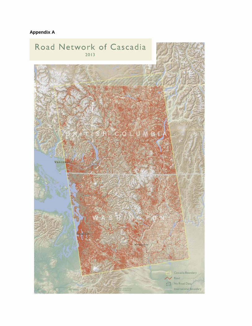
Roads of all kinds-from highways to gravel single lane routes-provide valuable access to the landscape of
Cascadia, while simultaneously leaving a tremendous footprint on the landscape (Appendix A). Access is
1 Cascadia Partner Forum website, www.cascadiapartnerforum.org

needed for land and species management, recreation, and public enjoyment. Roads can also pose natural
resource risks at various ecological scales to the landscape from reducing watershed health and security
habitats for wildlife to providing vectors that facilitate the spread of invasive plants and fragmenting
habitats. Risks both to natural resources and the infrastructure only increase with projected changes to
climate in Cascadia.2 Identifying a balanced, sustainable road system that offers needed access to our
landscape while ensuring healthy watersheds and habitats is therefore a high priority of the partner forum.
The Great Northern LCC Strategic Plan identifies 30 conservation targets, 29 of which are present in
Cascadia. We propose to conduct conservation design planning on four conservation targets in Cascadia
that meet the following criteria: relevant across the full spatial scale of Cascadia, strong transboundary
expertise, timely priority for management decisions in the next 18-months, and scientifically linked to the
effects of our identified landscape stressor. These four conservation targets are grizzly bear, salmon,
terrestrial and aquatic connectivity:
Grizzly bears once had the widest distribution of any bears in the world, including throughout
Cascadia, but due to a suite of interacting landscape stressors impacting both the populations and
their habitats grizzly range has significantly decreased. British Columbia has an estimated half of
Canada’s grizzlies, but they are in sharp decline. In the Southern Interior Ecoprovince within the
transboundary North Cascades Grizzly Bear Ecosystem the grizzly is “considered to be on the
edge of disappearance”.3 Recovery planning efforts on both sides of the border depend upon one
another, requiring transboundary coordination in planning and implementation. Grizzlies are
displaced from high traffic roads, but more importantly, highways can create population fractures
and bear mortalities across the species distribution in North America are close to roads.
Salmon are an icon of the Pacific Northwest, and rivers within Cascadia are home to runs of all
Pacific salmon species: chinook (king), coho, chum, pink and sockeye. The complexity of the life
cycle of salmon and the significant physiological changes that occur between each stage of the
salmon’s life make them particularly susceptible to a changing environment. The pattern of
waterways throughout Cascadia demand coordination across land management and political
borders to protect this species. Roads can pose barriers to access of aquatic habitats, as well as
risks to habitat quality through increased sedimentation and disturbance of riparian areas.
Washington has a rich recent history in scientific collaboration on terrestrial connectivity
through the Washington Wildlife Habitat Connectivity Working Group4 (WHCWG). Formed in
2007, the group’s purpose is to produce scientific analyses and tools necessary to maintain and
restore a connected network of habitats in Washington and surrounding habitats. Two years ago
the working group re-vamped their Transboundary Subgroup with a particular focus on the
landscape close to the internal border between Washington and British Columbia, dividing it into
three subregions for further collaboration: Cascades-Coastal, Okanagan-Kettle, and Columbia
Mountains-Selkirk. Resistance values are associated with roads due to their impact on reducing
the permeability of a landscape for a range of species.
Collaboration to maintain and restore aquatic connectivity throughout Cascadia has occurred by
a variety of methods, including individual land ownerships, basin and watershed collaborations,
2 Bepple, Jon. Wildlinks 2013: A Workshop Of The Cascadia Partner Forum, Summary Report. March 2014.
3 Ministry of Environment, Lands and Parks. 1995. Conservation of grizzly bears in British Columbia.
4 Washington Wildlife Habitat Connectivity Working Group, www.waconnected.org
and aquatic species recovery plans. Each recognizes the importance of connectivity of a waterway
with its floodplain horizontally and throughout its flow pathway. The density, location, design,
and maintenance of roads throughout the landscape impact this connectivity from creating
vertical incision of stream banks to re-channeling water. These impacts not only effect watershed
health today, but increase risk to infrastructure and the rate at which water is lost on the landscape
as we consider impacts from a changing climate.
Land and species planning efforts are underway today in Cascadia that will influence how our resources
are managed for decades to come. We strongly believe that both high impact dialogue with partners and
stakeholders and meaningful final decisions can only be achieved if the best available information is
available to display the current condition as well as modeling the risks and benefits of potential future
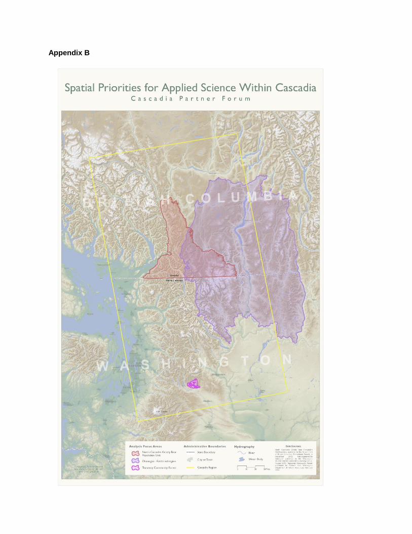
scenarios. Three landscapes of varying spatial scale are undergoing robust collaboration in the coming 24
months (Appendix B). All face multiple landscape stressors, but share at least one common land use
change vital to address in any long-term plan towards a more resilient landscape – roads. These
collaborative efforts include:
Established in 1995, the North Cascades Grizzly Bear Population Unit (NCGBPU) is the linchpin
in a regional bear recovery strategy as it links the wilder North Cascades in Washington to more
intact habitats in British Columbia where bears exist today in greater numbers. The Province
recognizes that through ongoing land use planning and resource management initiatives such as
the Integrated Decision Making (IDM) initiative, in conjunction with a regional species recovery
planning, there is an opportunity to halt and reverse habitat loss trends to provide a more
optimistic outlook to this species’ future. Examining current and potential future scenarios of
grizzly bear security habitat and linkages within the NCGBPU with a special focus on the impact
of roads will inform management options for the highways and habitat in this vital area.
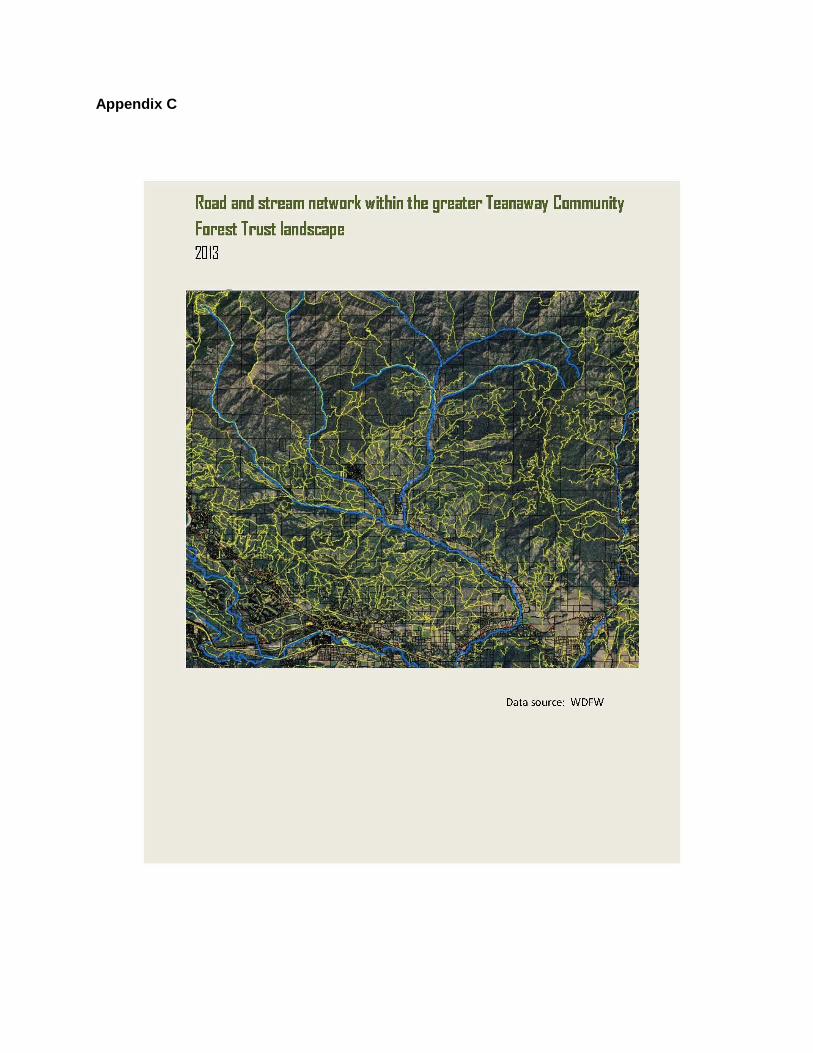
Last fall the Washington State Department of Natural Resources (DNR) and the Department of
Fish and Wildlife (WDFW) announced the purchase of 50,272 acres in the headwaters of the
Yakima Basin watershed, an area that has been designated as the Teanaway Community Forest5.
The forest will be managed through a partnership between DNR and WDFW, with input from the
local community and interested stakeholders. Acquisition of the property is a key step in
implementing the Yakima Basin Integrated Plan, an initiative developed by a coalition of public
and private organizations to safeguard the basin’s water supply, restore fisheries, conserve
habitat, preserve working lands, and enhance recreational opportunities. The land currently has an
existing road network (Appendix C). As the agencies and stakeholders develop a management
plan that will balance restoring ecological function and resiliency to this watershed within
Cascadia, an analysis and interpretation of the road network will be necessary.
In 2012, the Transboundary Subgroup of the WHCWG prioritized the Okanagan-Kettle subregion
stretching from the Cascade crest eastward through the Kettle River Range for habitat
connectivity analyses both in current condition and with impacts from climate change. Highway
97 and Route 3 act as large fractures to movement on the landscape for wildlife, while individual
linkages that are the most permeable through these fracture zones are being identified to inform
linkage scale conservation planning. Providing scenario planning within a linkage that considers
5 Teanaway Community Forest Trust,
http://www.dnr.wa.gov/BusinessPermits/Topics/OtherLandTransactions/Pages/amp_teanaway.aspx
multiple restoration options for the network of roads on the landscape will inform options for
restoring permeability, and define the scale at which conservation will have an impact. Major
landowners and stakeholders on this landscape include BC Parks, Ministry of Forests, Lands, and
Natural Resources, Colville and Okanogan-Wenatchee National Forests, Okanagan Nation
Alliance First Member Nations, and Colville Confederated Tribes. Each has decision and
planning efforts that will be informed by this work, ranging from forest plan revisions to site level
investments.
Objectives:
Objective 1. Contribute to GNLCC Science Plan through development of conservation design for four
conservation targets.
Task 1.1. Establish two leads for each conservation target (one from each side of the border) to be
matched with a Cascadia Partner Forum intern or fellow.
Task 1.2 Identify GNLCC-wide concepts within the Science Plan for each conservation target, and
overlap of conservation target with other GNLCC Ecotypic Areas.
Task 1.3 Identify existing Cascadia planning bodies and experts for each target to assist in development
and review of plan.
Task 1.4 Develop draft report for each conservation target including current status in Cascadia and in
relation to greater GNLCC target objectives, conceptual model, priority stressors, conservation
threats/actions/limiting factors, quantifiable objectives and metrics, conservation value analysis, and
future revision process and schedule recommendation.
Task 1.5 Present draft concepts to Cascadia network through workshop, webinars, and meetings
encompassed in an open review period including potential draft revisions and review.
Task 1.6 Incorporate feedback from review, and finalize into final report.
Task 1.7 Submit to GNLCC for integration in Science Plan and share final product for each conservation
target with relevant land and species managers and partnerships to ensure integration (i.e. Mid and Upper
Columbia Salmon Recovery Boards, North Cascades Interagency Grizzly Bear Subcommittee, US Fish
and Wildlife Service, Ministry of Forests, Lands, and Natural Resource Operations).
Objective 2. Evaluate existing information and develop new analyses on the impact of roads to one or
more habitat values tied to the conservation targets selected above to inform three land management
planning efforts.
Task 2.1 Define specific science question regarding risks associated with roads and natural resources with
managers and stakeholders in each geography, including current condition and potential future scenarios.
Task 2.2 Synthesize existing scientific information relevant to topic, landscape, and data layers available
for analyses in a study plan for each landscape.
Task 2.3 Conduct analyses including current condition and potential future management and ecological
scenarios (including projected impacts of climate change).
Task 2.4 Produce report, GIS decision support tool, and associated materials to share with management
agencies and stakeholders.
Deliverables:
In fulfilling Objective 1, we will generate a final report outlining for each of the four conservation targets
the following: Summary of current status in Cascadia and in relation to greater GNLCC target objectives,
conceptual model, priority stressors (climate, invasives and land use change), conservation
threats/actions/limiting factors, quantifiable objectives and metrics, conservation value analysis, and plan
providing regular updates and revisions to this plan. Fulfillment of Objective 2 will result in deliverables
clearly defined with the management agencies and stakeholders engaged on each landscape that will
include a study plan, final report (including purpose statement, landscape overview, methodology, results,
and discussion), GIS decision support tool to evaluate scenarios for road management and restoration,
maps, and data layer package.
Statement of Compliance: The Project Coordinator and Principal Investigators for this funding
request have read Great Northern Landscape Conservation Cooperative Information Management,
Delivery, and Sharing Standards and agree to comply with those standards if the proposal is selected. We
cannot release to the Public Domain data for Species deemed Sensitive by government agencies, tribes,
and First Nations that may be used to inform our analyses.
Schedule:
Objective 1 Task 1.1. Establish two leads for each conservation target (one from each side
of the border) to be matched with a forum intern or fellow.
July – August 2014
Task 1.2 Identify GNLCC-wide concepts within the Science Plan for each
conservation target, and overlap of conservation target with other GNLCC
Ecotypic Areas.
August 2014
Task 1.3 Identify existing Cascadia planning bodies and experts for each target
to assist in development and review of plan.
August – November 2014
Task 1.4 Develop draft September – November 2014
Task 1.5 Present draft concepts to Cascadia network through workshop,
webinars, and meetings encompassed in an open review period including
potential draft revisions and review.
November – March 2015
Task 1.6 Incorporate feedback from review, and finalize into final report. March – June 2015
Task 1.7 Submit to GNLCC for integration in Science Plan and share final
product for each conservation target with relevant land and species managers
and partnerships to ensure integration
June – July 2015, with continued
opportunities beyond this period
expected
Objective 2
Task 2.1 Define specific science question regarding risks associated with roads
and natural resources with managers and stakeholders in each geography
including current condition and potential future scenarios to examine.
July – October 2014
Task 2.2 Synthesize existing scientific information relevant to both topic and
landscape and data layers available for analyses in a study plan for each
landscape.
October – January 2015
Task 2.3 Conduct analyses including current condition and potential future
scenarios (generated with partners)
February – May 2015
Task 2.4 Produce final report, GIS decision support tool, and associated
materials to share with management agencies and stakeholders
June – July 2015
Task 2.5 Present and facilitate discussions with each management agency and
stakeholder group on the three landscapes to initiate integration into decisions.
Scheduled by July 2015, but
dependent on schedules
Appendices
Appendix A – Map product “Road Network of Cascadia 2013” generated for an access management
workshop of the Cascadia Partner Forum at WildLinks 2013 in Manning Park Resort, BC.
Appendix B - Spatial Priorities for Applied Science within Cascadia
Appendix C - Road and stream network within the greater Teanaway Community Forest Trust landscape
Appendix A
Appendix B
Appendix C