strategic minerals investigations 1940 · 292 42. £, nodular chromlte from the black spot no. 1...
TRANSCRIPT

UNITED STATES DEPARTMENT OF THE INTERIOR Harold L. Ickes, Secretary
^ I ^.GEOLOGICAL SURVEY '^ W. C. Mendenhall, Director
-P Bulletin 922
STRATEGIC MINERALS INVESTIGATIONS1940
PART 1, A-K
Short papers and preliminary reports by
R. J. ROBERTS, T. P. THAYER, D. W. LEMMON
and others
.;...«. : : */ '.-. :
UNITED STATES
GOVERNMENT PRINTING OFFICE
WASHINGTON : 1941
\y

CONTENTS
[The letters in parentheses preceding the titles are those used to designate the papers for separate publication]
Page(A) Quicksilver deposits of the Bottle Creek district,
Humboldt County, Nevada, by R. J. Roberts (pub lished in July 1940)............................... 0 1
(B) Quicksilver deposits of the Mount Diablo district, Contra Costa County, California, by C. P. Ross (published in July 1940)............................ 31
(C) Manganese deposits in the Little Florida Mountains, Luna County, New Mexico, by S. G. Lasky (pub lished in August 1940).............................. 55
(D) Chromite deposits of Grant County, Oregon, by T. P.Thayer (published In September 1940)................ 75
(E) Quicksilver deposit at Buckskin Peak, National Min ing district, Humboldt County, Nevada, by R. J. Roberts, (published in September 1940)............... 115
(F) Tungsten deposits of Boulder County, Colorado, byT. S. Lovering (published in September 1940)........ 135
(G) Manganese deposits at Philipsburg, Granite County, Montana, by E. N. Goddard (published in Septem ber 1940)........................................... 157
(H) Tungsten deposits of the Atolia district, San Bernardino and Kern Counties, California, by D. M. Lemmon and J. V» N. Dorr 2d (published in November 1940....................................... 205
(I) Antimony deposits of a part of the Yellow pine dis trict, Valley County, Idaho, by D. E. White (pub lished in November 1940)............................ 247
(J) Chromite deposits in the Seiad quadrangle, Siskiyou County, California, by G. A. Rynearson and C. T.' Smith (published in February 1941).................. 281
(K) Antimony deposits of the Wlldrose Canyon area, Inyo County, California, by D. E. White (published in December 1940)....................................... 307
III

ILLUSTRATIONS
Page
Plate 1. Geologic map and sections of Bottle Creekdistrict, Nevada................o............ 4
2. Map and sections of White Peak workings ofScossa mine................o................. 20
3. Map and section of Blue Can mine............... 204. Map and sections of McAdoo mine................ 205. Map and sections of Birthday mine.............. 216. Geologic map of the Mount Diablo mine.......... 347. Geologic map of Mount Diablo region, Contra
Costa County, California..................... 358. Geologic map of Mill Workings, Mount Diablo
mine......................................... 429. Topographic and generalized geologic map of
Little Florida Mountains, N. Mex............. 5810. Geologic plan and projection of Manganese
Valley mine.................................. 66llo Geologic plan and projection of Luna mine,,..... 6712. Map of serpentine belts of Strawberry Range
and chromite deposits of Grant County, Oreg.. 8413. Preliminary geologic map of east half of Can
yon City belt of ultramafic rocks, Grant County, Oreg............................ In pocket
14o Geologic map of Chambers chromite depositand sections through diamond-drill holes..... 100
15. Geologic map and section of Iron King chro mite deposit.................................. 100
16. View of quarry at Iron King mine............... 10117. Geologic map and sections of Dry Camp chro
mite deposit...................o........ In pocket18. Geologic map of Marks & Thompson chromite
deposit...................................... 10819. Plan of Ray mine............................... 10820. Plan and section of Silver Lease chromite
deposit.............................. .. ...... 11021. Geologic map and sections of Buckskin Peak..... 11822. A, View of siliceous sinter blanket from the
south; B, Cliff exposure of sinter on the southeast side of the blanket................ 126
23. Cinnabar-bearing layers........................ 12724. Map showing location of Boulder County tung
sten belt and general regional geology.v In pocket25. Geologic map 'of Boulder County tungsten
belt and adjacent area.................. In pocket26. Geologic map of the Philipsburg district.. In pocke't 27o Polished ore specimen from Algonquin mine...... 17628. Manganese-oxide ore. A_, Prom Algonquin mine;
B, From Bryant mine.......................... 17629. Manganese-oxide ore from Headlight mine and
Sharktown glory hole......................... 17630. Cross sections of parts of the manganese-
producing area............................... 18431. Geologic plan of the workings of the Head
light mine 0 ............................. In pocket32. Maps of the Scratch Awl mine.............. In pocket
IV

ILLUSTRATIONS V
Page
Plate 33. Geologic plan of the 400- and 500-footlevels of the Trout mine............... In pocket
34o Geologic plan and section of the WestAlgonquin and Bernard mines.......;.... In pocket
| 35. Geologic map of the Atolia mining dis-,4 trlcto................................. In pocket
36-. Plan and sections of the principal minesof the Atolia mining district.......... In pocket
37o Claim map of the Atolia mining district.. In pocket38. Geologic map of the Yellow Pine mine
area 0 .................................. In pocket39. Topographic map of the Yellow Pine mine....... 27440. Preliminary geologic map and sections of
the northeastern part of the Seiad quad rangle , California..................... In pocket
41. Chromite ore from the Jumbo claim............. 29242. £, Nodular chromlte from the Black Spot No. 1
claim; B, Rudely banded chromlte ore from the Selad Creek deposit..................... 292
43. Orbicular chromite ore from the Octopusclaim....................................... 292
44. Map and sections of the Selad Creek chromltedeposit................................ In pocket
45<> Geologic map and cross section of a part of the area between Wildrose and Tuber Can yons ................................... In pocke t
46<> Geologic map and cross section of thenorth side of Wildrose Canyon............... 318
Figure lo Index map of Nevada showing location of Bot tle Creek district.......................... 3
2. Index map of part of northern Californiashowing location of Mount Diablo district... 32
3. Structure sections through Mill Workings,Mount Diablo mine........................... 48
4. Index map of New Mexico showing location ofLittle Florida Mountains.................... 56
5o Sketch showing common stratigraphic relations of rocks of Little Florida Mountains, N. Mexo........................................ 59
6 8 View of Manganese Valley vein. ....<>........... 627 0 "Pudding ore" in Luna mine.................... 638. Polished specimen of "pudding ore"............ 649. Polished specimen of vein matter showing in-
tergrowth of quartz and calcite............. 6610o Geologic plan of tunnel on Manganese Valley
No. 13 claim................................ 6911. Assay map of high-grade footwall streak in
Manganese Valley mine....................... 7212. Specimen from dump of Ward mine showing rela
tions between nodular ore, spotted ore, and barren dunite............................... 90
13. Superimposed linear and planar banding innodular chromlte ore........................ 91
14. Plan of southwest end of southwest ore bodyat Chambers mine............................ 93
15. Plan of Black Velvet chromite deposit......... 10116 0 Plan of Bald Eagle chromite deposit........... 10417o Plan and section of Celebration mine.......... 10518« Plan of Ray chromlte prospects between Over-
holt and Indian Creeks...................... 10919o Plan of principal opening on Norway claim..... Ill20. Index map of Nevada showing location of Na
tional mining district and other cinnabar- bearing silicsous sinter deposits........... 117

VI ILLUSTRATIONS **
Page ^
Figure 21. Geologic map and section of National mining ^ district and Canyon Creek, Humboldt Coun ty, Nev...................................... 120
22. Map and sections of the East workings, McCor- '-^ mick group.»................................ 128
23. Map and section of the West workings, McCor- -s mlck groupo°................................. . 129
24. Diagram showing possible extension of ore 3 zones, McCormick group...................... 130
25o Perberite concentrates produced in Boulder > County 1900-1938.0..............o........... 136
26 0 Diagram representing conditions of mineral!- .( zation 0 ..................................... 145 v
27 0 Longitudinal section of Cold Spring mine...... 14728o Localization of ore at change in the course -
of a vein................................... 14929. Localization of ore at junction of two inter
secting veinso.............................. 15030o Localization of ore at junction of a branch
vein with a breccia reef.................... 15131. Index map of Montana showing the location of *
the Philipsburg district.................... 15932o Plan and sections of manganese ore body at v
Algonquln mine 0 .............................. 18033. Sketch of ore body in Sharktown glory hole 0 ..o 18134. Longitudinal section of the Pocahontas vein,
Trout mine.................................. 19735. Plan of the upper six levels of the Trout
mine........................................ 19836. Index map of southern California showing loca
tion of the Atolia mining district.......... 20637. Section through the Union No. 1 shaft......... 23338. Section through the Acaley mine............... 23739. Veins and faults on the first level of the
Paradox No. 3 mine.......................... 24040c Index map of Idaho showing location of the
Yellow Pine district........................ 24941. Index map of northern California showing loca
tion of the Seiad quadrangle................ 28242» Diagram showing results of metallurgical tests
made on Seiad Creek ore..................... 29243. Plans of underground workings at the Seiad
Creek chromite deposit...................... 29944 0 Map of the Pairview group of chromite claims. , 30245<> Index map showing relative positions of claims
in the two areas mapped geologically........ 30946o Diagrammatic section showing the relation of
a known vein to an anticline and a syn- cline....................................... 318

INDEX
A Page
Abstracts of reports................. 1,31, 55, 75, 115, 135, 157, 205, 247-248, 281, 307.
Acaleymlne, geology of.......... 236, 237Acknowledgments for aid.............. 2-4,
34, 59, 77-78, 116, 135-136, 158,211, 251, 281-283, 308-309.
Ajax mine, workings of............... 103Algonquln mine, manganese deposit in. 180,
202 Alice Bell claims, workings of....... 29Amador claim, workings of........... 25-27American Gold & Tungsten Corporation,
property of.................... 244Amity mine, workings of........... 236-237Another Chance claim. See Stone &
Hankins mine. Anthill claims, workings of......... 22-25Antimony deposits, Wildrose Canyon
area, Calif..... 307-325, pis. 45-46Yellow Pine district, Idaho....... 247-
279, pis. 38-39 Antimony Ridge, antimony deposits
near........................ 321-324Apex claim, workings of............. 28-29Atolia district, Calif., geology of.. 211-
216, pi. 35 tungsten deposits in.............. 205-
245, pis. 35-37 Atolia Rand Placers, Inc., holdings
of............................. 242
B
Bald Eagle chromite deposit, charac ter of......................... 104
Baldwin mine, workings of........... 28-29Barton claim, workings of............ 306Bernard mine, workings of 202-204, pi. 34 Big Ben shaft, geology of............ 241Big Bertha chromite deposits, charac
ter of............'..... 105, 108-109Big Four claims, workings of......... 29Birthday mine, workings of... 25-27, pi. 5 Black Beauty claim, workings of..... 28-29Black Spot claims, chromite in....... 305Black Velvet claim, chromite deposit
in............................. 100Blackhawk Mining Co., property of.... 243Blue Bucket claims, workings of..... 28-29Blue Bucket Fraction claims, workings
of............................ 28-29Blue Can mine, workings of... 19-22, pi. 3 Blue Eagle claims, workings of...... 22-25Bluebird claims, workings of........ 22-25Bluebird Fraction claim, workings of 22-25 Bottle Creek district, Nev., geology
of....................... 4-9, pi. 1quicksilver deposits of 1-29, pis. 1-5 quicksilver production in......... 4
Bottle Creek Mercury claim, workingsof..................... 19-22, pi. 3
Boulder County, Colo., geology of.... 137-141, pi. 25
tungsten deposits of.............. 135-156, pis. 24-25
Buckskin Peak, Ne\ , geology of...... 119-124, pi. 21
mine workings at....... 127-132, pi. 21quicksilver deposits of ....... 4... 115-
133, pis. 21-23Bull Spring, Oreg. . chromite pros
pects near..................... 113
C . ' Page
California, chromite deposits in.. 281-306 quicksilver deposits In.........., 31-54tungsten deposits in........... 205-245
Campbell mine, location of........... 110Celebration mine, workings of..... 104-105Cerro Colorado claim. See Liberty
claim.Chambers mine, geology of... 96-98, pi. 14 Chromite claim. See Octopus claim. Chromite deposits, Grant County,
Oreg............. 75-113, pis. 12-20Seiad quadratic, Calif........... 281-
306, pis. 40-44Cliff Millslte mine, manganese depos
it in.......................... 202Cliff mine, manganese deposit In 180, 202 Climax mine, manganese deposit in.... 202Cold Spring mine, tungsten deposit of 143,
146-149, 152 Colorado, tungsten deposits in.... 135-156Combination mine, workings of........ 322Conger mine, tungsten deposit of 146, 148 Contra Costa County, Calif., quick
silver deposits in.. 31-54, pis. 6-8 Coyle mine, manganese deposit in..... 202
Delore prospects, production of chro mite from................... 112-113
Dolbear mine, chromite in............ 306Dorr, J. V. N., 2d, Lemmon, D. M.,
and, Tungsten deposits of the Atolia district, San Bernardi- no and Kern Counties, Calif.... 205-
245, pis. 35-37Dry Camp mine, chromite deposit of... 100-
102, pi. 17Durango mine, manganese deposit in 180,202
Fairvlew group, chromite deposit of.. 301-303
Federal mine, workings of......... 241-242Flatiron mine, workings of........... 238-
239, pis. 35-36 Fraction claim, workings of.......... 22-25
Geologic maps:Atolia district, San Bernardino
and Kern Counties, Calif..... pi. 35Bottle Creek district, Humboldt
County, Nev................... pi. 1Boulder County, Colo............. pi. 25Buckskin Peak, National mining
district, Humboldt County, Nev.......................... pi. 21
Grant County, Oreg.............. pi. 13Little Florida Mountains, Luna
County, N. Mex................ ppl. 9Mount Diablo district, Contra
Costa County, Calif........... pi. 7Phlllpsburg district, Granite
County, Mont................. pi. 26Seiad quadrangle, Slskiyou County,
Calif........................ pi. 40Wildrose Canyon area,. Inyo Coun
ty, Calif................ pis. 45-46Yellow Pine district, Valley Coun
ty, Idaho.................... pi. 38
VII

vm INDEX
Page
Glasscock claims, production of chro-mite from................... 111-112
Ooddard, E. N.,.Manganese deposits at Phlllpaburg, Granite County, Mont............ 157-204, pis. 26-34
Goldstone_ mine, condition of......... 237Qoodenough claim, workings of 19-22, pi. 3 Granite County, Mont., manganese de
posits in....... 157-204, pis. 26-34Grant County, Oreg., chromlte depos
its of........... 75-113, pis. 12-20geology of............... 78-87, pi. 13
H
H. * M. 2 claim, workings of...... 127-129Hamburg Bar mine. See Fairview group. Hanenkrat prospect. See Big Bertha. Hanklns mine, production of chromite
from........................... 112Headlight mine, geology and workings
of......... 181, 189-192, pis. 29-31Hector claim, workings of............ 25-27Horton mine, manganese deposit in 180, 202 Howard prospects, chromlte deposit of 105,
107-108Huffman mine, manganese deposit in... 202 Humboldt County, Nev., quicksilver
deposits in................... 1-29,115-133, pla. 1-5, 21-23
I Guess shaft, exploration through... 245 Idaho, antimony deposits in....... 247-279Inyo County, Calif., antimony depos
its in.......... 307-325, pis. 45-46Iron King mine, geology of..'......... 98-
100, pis. 15-16
Jones tunnel, workings of. Jumbo claim, workings of..
45305
Kennedy mine, workings' of............ 324Kern County, Calif., tungsten depos
its in.......... 205-245, pis. 35-37Kingsley mine, chromite deposit of 105,106
Lasky, 3. 0., Manganese deposits in the Little Florida Mountains, Luna County, N. Mex. 55-73, pis. 9-11
Last Chance claim, workings of...... 25-27Lemmon, D. M., and Dorr, J. V. N.,
2d, Tungsten deposits of the Atolla district, San Bernardi- no and Kern Counties, Calif.... 205-
245, pis. 35-37 Liberty claim, workings of........ 304-305Lily tunnel, ore shoot in............ 150Little Dandy mine, manganese deposit
in............................. 202Little Florida Mountains, N. Mex.,
geology of............. 59-61, pi. 9manganese deposits in 55-73, pis. 9-11
Logan mine, tungsten deposits of.ft... 143 Lone Star Fraction claim, workings of 25-
27243243
Long's Folly claim, workings of......Long's Folly Extension, workings of..Levering, T. 3., Tungsten deposits of
Boulder County, Colo........... 135-156, pis. 24-25
Luna County, N. Mex., manganese de posits in.......... 55-73, pis. 9-11
Luna mine, workings of..... 71, 73, pi. 11
M
Manganese deposits, Little FloridaMountains, N. Mex. 55-73, pis. 9-11
Phillpsburg, Mont. 157-204, pis. 26-34 Manganese Valley mine, production
from.......................... 57-58workings of.......... 70-71, 72, pi. 10
Page
Marks & Thompson mine, chromlte de posit In................ 102, pi. 18
Mary Lou claim. See Octopus claim.McAdoo mine, workings of..... 22-25, pi. 4McConnlck group, mine workings in 127-132 McGuffy Creek chroralte deposits,
claims on................... 303-305Meadow Creek mfne, ore deposits of 261-263 Mercury King claim, workings of..... 25-27Mill Workings, features of........... 34,
41-42, 46-49, pi. 8 Milton; Charles, analyses by......... 291Mohawk mine, workings of............. 323Monarch mine, workings of......... 321-322Monopoly mine, features of........ 322-323Montana, manganese deposits in.... 157-204Morning mine, manganese deposit in... 180,
Mount Dlablo district, Calif., geolo gy of............... 35-40, pis.
quicksilver deposits of 31-54, pis.Mount Diablo mine, quicksilver pro
duction from.................. 2
202
6-8 6-8
N
Napatftma (?) claim. See Neptune claim. National mining district, Nov.,
quicksilver deposits of........ 115-133, pis. 21-23
Neptune claim, workings of........... 305Nevada, quicksilver deposits in...... 1-
29, 115-133New Mexico, manganese deposits in... 55-73 Nlebuhr mine, workings of............ 29Norway mine, production from..... 110-111
Octopus claim, workings of........... 304O'Nelll shaft, exploration through... 244 Ore deposits, Atolia district,
Calif....................... 216-229Bottle Creek district, Nev....... 10-16Boulder County, Colo........... 141-156Buckskin Peak, Nev............. 124-133Grant County, Oreg............... 87-95Little Florida Mountains, N. Mex. 61-67 Mount Diablo district, Calif..... 40-52Phllipsburg district, Mont..... 170-188Seiad quadrangle, Calif........ 289-297Wlldrose Canyon area, Calif.... 316-324Yellow Pine district, Idaho.... 259-271
Ore reserves, Atolia district,Calif.............. 223-224, 228-229
Bottle Creek district, Nev....... 14-16Boulder County, Colo.............. 156Buckskin Peak, Nev............. 132-133Grant County, Oreg............... 95-96Little Florida Mountains, N. Mex. 67-70 Phillpsburg district, Mont........ 185-
188, 191-192 Seiad quadrangle, Calif........... 297Wlldrose Canyon area, Calif.... 324-325Yellow Pine district, Idaho.... 271-279
Oregon, chromlte deposits in....... 75-113Osdlck group, geology of.......... 240-241
Papoose mine, workings of............ 238Par mine, workings of 238-239, pis. 35-36 Paradox No. 1 and No. 3 mines, geolo
gy of ...................... 239,240Perhaps claim, workings of.......... 25-27Phllipsburg district, Mont., geology
of.................. 162-170, pi. 26manganese deposits In............. 157-
204, pis. 26-34production of manganese from... 160-161
Pickup claims, workings on.......... 22-25Pine Creek, chromite prospects near.. 105,
108Powers mine, chromite deposit of 105, 107 Prospecting, suggestions for, in
Atolia district, Calif......... 223in Boulder County, Colo........ 153-155In Mount Diablo district, Calif. 52-53 In Phillpsburg district, Mont. 183-185 in Yellow Plrie district, Idaho 267, 269

Q Page
Queen of the May mine, production ofchromite from............... 111-112
Quicksilver deposits, Bottle Creekdistrict, Nev........ 1-29, pis. 1-5
Buckskin Peak, Nev. 115-133, pis. 21-23 Mount Dlablo district, Calif...... 31-
54, pis. 6-8 Quicksilver production, in Bottle
Creek district, Nev............ 4in-Mount Diablo district, Calif... 34
Rainbow Fraction claim, workings of 22-25 Rainstorm mine, workings of....... 236-237Ray mine, workings of..... 102-103, pi. 19Red Butte claim, workings of......... 304Red Ore claims, workings of......... 18-19Red Ore Extension claim, workings of 22-25 Redemption mine, manganese deposit in 202 Redondo Pete claim, workings of...... 242Reed mine, location of............... 110Rhyne tunnel, workings of........... 45-46Roberts, R. J., Quicksilver deposit
at Buckskin Peak, National min ing district, Humboldt County, Nev............. . 115-133, pis. 21-23
Quicksilver deposits of the Bottle Creek district, Humboldt Coun ty, Nev.............. 1-29, pis. 1-5
Rogers mine, tungsten deposit of.. 150-151 Ross, Ci P., Quicksilver deposits of
the Mount Diablo district, Con tra Costa County, Calif........ SI-
54, pis. 6-8 Ryne mine, quicksilver production
from........................... 33Rynearson, 0. A., and Smith, C. T.,
Chromite deposits In the Seiad quadrangle, Sisklyou County, Calif........... 281-306, pis. 40-44
St. Elmo mine, workings of........... 243San Bemardino County, Calif., tung
sten deposits In 205-245, pis. 35-37 Scossa mine, workings of..... 16-19, pi. 2Scratch Awl mine, geology and work
ings of............. 192-396, pi. 32Seiad Creek chromite deposit, geology
and workings of..... 298-301, pi. 44Seiad quadrangle, Calif., chromite
deposits in.................... 281-306, pis. 40-44
geology of............. 284-289, pi. 40Senator claims, workings of......... 28-29Sharktown mine, manganese deposit in 181,
202Sheep Rock chromite deposits, char
acter of.................... 108-109Silver Lease mine, workings of 11.0, pi. 20 Siskiyou County, Calif., chromite
deposits In.... 281-306, pla. 40-44Skylark mine, geology of............. 241Smith, C. T., Rynearson, 0. A., and,
Chromite deposits in the Seiad quadrangle, Sisklyou County, Calif........... 281-306, pis. 40-44
Smith & OeitsfieId mine, productionfrom........................ 110-111
Spanish mine, workings of............ 238-239, pis. 35-36
Page
Spring and Chrome Ridge mine. SeeHankins mine.
Standard claims, workings of........ 22-25Stone & Hankins mine, production of
chromite from............... 111-112Strawberry Range, chromite deposits
of........................... 76-113Sun shaft, exploration through....... 244Sunflower claim, workings of........ 28-29Sun-Set claims, workings of.......... 29
Thayer, T. P., Chromite deposits ofGrant County, Oreg............. 75-
113, pis. 12-20 Tiger claims, workings of........... 22-25Tin Can mine. See Blue Can mine.Top Notch claim, workings of......... 244Trout mine, geology and workings of.. 196-
202, pi. 33 True Fissure mine, manganese deposit
in............................. 202Tungsten deposits, Atolla district,
Calif........... 205-245, pis. 35-37Boulder County, Colo.............. 135-
156, pis. 24-25
Uncle Sam mine, production of chro mite from.................... 111-112
Union mine, geology and workings of 232-235, pi. 36
Valley County, Idaho, antimony depos its In.......... 247-279, pis. 38-39
Veta Grande claim. See Red Butte claim.
W
Ward mine, chromite deposit in.... 105-106West Algonquln mine, workings of..... 202-
204, pi. 34 Western Metals Co., production by.... 308White, D. E., Antimony deposits of a
part of the Yellow Pine dis trict, Valley County, Idaho..,. 247-
279, pis. 38-39Antimony deposits of the Wlldrose
Canyon area, Inyo County, Calif.......................... 307-
325, pis. 45-46 White Peak claims, workings of....... 17-
18, pi. 2Wildrose Antimony mine, workings of.. 321 Wildrose Canyon area,.Calif., antimo
ny deposits of................. 307-325, pis. 45-46
field work in.................. 308-309geology of......................... 310-
324, pis. 45-46
Yellow Pine district, Idaho, antimonydeposits in.................... 247-
279, pis. 38-39 geology of............. 252-258, pi. 38
Yellow Pine mine, tungsten deposit of 143
o

UNITED STATES DEPARTMENT OF THE INTERIOR Harold L. Ickes, Secretary
GEOLOGICAL SURVEY W. C. Mcndcnhall, Director
Bulletin 922-A
QUICKSILVER DEPOSITS
OF THE BOTTLE CREEK DISTRICT
HUMBOLDT COUNTY, NEVADA
A PRELIMINARY REPORT
RALPH J. ROBERTS
Strategic Minerals Investigations, 1940
(Pages 1-29)
UNITED STATES
GOVERNMENT PRINTING OFFICE
WASHINGTON : 1940
For Bale by the Superintendent of Documents, Washington, ,D. C. Price 35 cents


CONTENTS
PageAbstract............................................... 1Introduction and history............................... 2Geology................................................ 4
pre-Tertiary rocks................................. 5Tertiary (?) rocks................................. 6
Lower tuffs, conglomerate, and sandstone....... 6. Basalt.......................................... 6Upper tuffs and clays.......................... 7Diabase dikes.................................. 7Rhyolite....................................... 8
Quaternary deposits................................ 8Structure.......................................... 8
Ore bodies............................................. 10Cinnabar-bearing fault zones....................... 10Cinnabar-bearing diabase dikes..................... 10
Mineralogy..................................... 11Localization of ore bodies..................... 12Size and grade of ore bodies................... 14Reserves....................................... 14
Mines and prospects.................................... 16Scossa mine........................................ 16
White Peak group............................... 17Red Ore group................................... 18
Blue Can mine...................................... 19McAdoo mine........................................ 22Birthday mine...................................... 25Baldwin mine....................................... 28Niebuhr mine....................................... 29
ILLUSTRATIONS
Page Plate 1. Geologic map and sections of Bottle Creek
district, Nevada........................... 42. Map and sections of White Peak workings of
Scossa mine................................ 203. Map and section of Blue Can mine............. 204. Map and sections of McAdoo mine.............. 205. Map and sections of Birthday mine............ 21
Figure 1. Index map of Nevada showing location ofBottle Creek district...................... 3
III


QUICKSILVER DEPOSITS OF BOTTLE CREEK DISTRICT
HUMBOLDT COUNTY, NEVADA
A PRELIMINARY REPORT
By Ralph J. Roberts
ABSTRACT
The Bottle Creek district in Humboldt County, northwest ern Nevada, produced 310 flasks of quicksilver between September 1938 and October 1939. Although underground work aggregates only about 2,000 feet, the outlook for future production appears promising.
The rocks include an older pre-Tertiary group of com plexly folded and faulted sedimentary and volcanic rocks and a later group probably of Tertiary age, that is also composed of volcanic and sedimentary rocks. The Tertiary (?) group has been divided into five units. Three of these units ; the lower tuffs, conglomerate, and sandstone, the basalt, and the upper tuffs and clays dip west and are In fault contact with the pre-Tertiary rocks. All are cut by diabase dikes and all are unconformably overlain by rhyolite flows that dip east.
There are two types of ore deposits: cinnabar-bearing faults and cinnabar-bearing diabase dikes. Prior to January 1940 all the production had come from the dikes, but recent development work has shown material of commercial grade in two fault zones. Ore shoots mined in the dikes are commonly small but of high grade and average about 30 pounds of quick silver to the ton.
In the engineering sense there are no proved reserves, but in the light of past production the probable reserves in known dikes to a depth of 150 feet are estimated at about 3,000 flasks of quicksilver,!/ which can be profitably mined so long as the price of quicksilver remains at $125 or more a flask.
I/ A flask contains 76 pounds.

2 STRATEGIC MINERALS INVESTIGATIONS, 1940
INTRODUCTION AND HISTORY
The Bottle Creek district is in Humboldt County, Nev.,
about 65 miles by road northwest of Winnemucca, in T. 40 N.,
R. 33 E. (fig. 1). The district is accessible throughout
the year, although rain and snow occasionally make the last
6 miles of road impassable for short periods. No previous
geologic mapping has been done in the area, but the district
was briefly visited and some prospects were described by2/
Vanderburg in 1937.-7 ,
The district lies in the foothills of the northeastern
part of the Jackson Mountains, a northward-trending fault-3/
block range in the northern part of the Great Basin. . Much
of the area mapped is a region of waste-covered slopes be
tween the rugged main range to the west and two rhyolite-
capped hills to the east. (See pi. 1.) Rock outcrops are
sparse and poor. There are no permanent streams, and water
for domestic purposes and mining is obtained from springs.
During August, September, and October, 1939, the writer,
assisted by Arthur E. Granger, spent 34 days in field work.
The geology and topography of 5^- square miles were mapped on
a scale of 1:12,000. The underground workings were mapped on
a scale of 1:240, or 20 feet to the inch. The operators and
miners in the district were uniformly courteous and helpful,
and the writer wishes especially to acknowledge the assist
ance of James and Arnold Scossa, D. J. Wootan, M. S. McCown,
Dr. W. C. McAdoo, Ao M. Tweedt, H. W. Baldwin, and T. C.
Niebuhr. The writer is also indebted to H. G. Ferguson,
2j Vanderlmrg, W. 0., Reconnaissance of mining distracts in Hunfooldt County, Nevada: U. S. Bur. Mines, I. C. 6995, p. 17, 1938.
3/ Russell, I.C., Geological history of Lake Lahontan: U. S. Oeol. Survey Mon. 11, p. 27, 1885.

QUICKSILVER DEPOSITS, BOTTLE CREEK DISTRICT, NEVADA 3
Figure 1. Index map of Nevada showing location of Bottle Creek district.

4 STRATEGIC MINERALS INVESTIGATIONS, 1940
T. B.. Nolan, and C. P. Ross of the Geological Survey for help
ful advice during field work and in the preparation of this
reports
Although the presence of cinnabar in the Bottle Creek4/
area has been known since about 1928, cinnabar lodes were
not discovered until September 1936, when James and Arnold
Scossa panned cinnabar from stream gravels in Halburg Canyon ,,
and traced the cinnabar to the area now Included in their
Red Ore group of claims. As news of the strike became known,
others staked adjoining ground, and cinnabar was discovered
on several claims. The first retort was installed by D. J.
Wootan, and production began in September 1938. The monthly
production of the district from September 1938 to September
1939 is as follows:
Production of quicksilver, in flasks, in the Bottle Creek district, 1938-39
September 1938.... 8 April 1939........ 13October. .......... 18 May. .............. 33November. ......... 20 June .............. 33December. ......... 29 July. ............. 36January 1939 ...... 25 August . ........... 37February. ......... 14 September. ........ 53March. ............ 11 Total 1938-39. ""
Late in 1938 and early in 1939 quicksilver ranged in
price from $75 to $93 a flask; in September 1939 it rose to
$165. As the district is new and the development is in its
early stages, there is no significant relation between output
and price of quicksilver.
GEOLOGY
The rocks of the Bottle Creek district (pi. 1) include
an older group of complexly folded and faulted sedimentary
and volcanic rocks of pre-T'ertiary age and a younger group
4/ Scossa, James, personal communication.57 Meyer, H. M., U. S. Bur. Mines, personal communication.

UNITED STATES DEPARTMENT OF THE INTERIOR GEOLOGICAL SURVEY BULLETIN 922 PLATE 1
EXPLANATION
Upper tuffs and clays
Lower tuffs, conglomerate,
Geology and topography byRalph J.Roberts and A.E.Granger
3,000 Feet
Phy II ite, greenstone, quartzite, etc.
Fault(Solid where exposed, dashed where concea/ed, doffed where inferred; arrow shows dip)
±*°'
Strike and dip
Shaft-<
Tunnelx
ProspectContour interval 25 feet Assumed sea level datum
6,000-,
'-Jd6,000
s,soo-
s,ooo
GEOLOGIC MAP AND SECTIONS OF BOTTLE CREEK DISTRICT,HUMBOLDT COUNTY, NEVADA
1940

' -'"'V
QUICKSILVER DEPOSITS, BOTTLE CREEK DISTRICT, NEVADA 5
of Tertiary (?) volcanic and sedimentary rocks that have been
tilted and faulted and only gently folded. Undeformed Qua
ternary deposits overlie both groups.
Pre-Tertlary rocks
The most extensive exposures of pre-Tertiary rocks are
along the western border of the dis.trict, but there are also
outcrops in the central and eastern parts where the over
lying Tertiary (?) rocks have been eroded.
Phyllite, limestone, and fine-grained sandstone are most
abundant in the western part of the district. They are for
the most part finely laminated, and where unaltered, they are
gray to black. Thin beds of quartzite are present in some
places*
Greenstones, which are altered andesitic and basaltic
rocks, and graywacke predominate in the central part of the
district. They are generally dark green when freshly broken
but weather to a reddish-brown soil. The graywackes cannot
everywhere > distinguished from the greenstones, but gener
ally the graywacke.s contain fragments of phyllite and argil-
lite and are locally well-bedded. In some places these rocks
have been hydrothermally altered and are, therefore, not
easily distinguished from the Tertiary (?) tuffs and sedi
mentary rocks. No fossils have been found in the pre-Terti
ary rocks, the specific age of which, consequently, is un
known. They are similar, however, to rocks that overlie
Pennsylvanian limestone and are overlain by the Koipato for
mation of Permian and Triassic age in the Sonoma Range quad
rangle to the southeast.229673 O 40 2

6 STRATEGIC MINERALS INVESTIGATIONS, 1940
Tertiary (?) rocks
The Tertiary (?) rocks of the district may be divided
into five units. The three oldest units, which may be con
veniently called the lower group, include a lower unit of
tuffs, conglomerate, and sandstone and an upper unit of tuffs
and clays separated by a basalt unit. These three units are
cut by diabase dikes, which contain the ore bodies. The low
er group and the diabase dikes are unconformably overlain by
rhyolite flows. No fossils were found in any of these rocks,
but they resemble known Tertiary rocks in adjoining areas.
Lower tuffs, conglomerate, and sandstone.--The lower
unit of tuffs, conglomerate, and sandstone is exposed at
three places in the central and southern parts of the dis
trict, but it is absent to the north, where basalt flows rest
directly on the pre-Tertiary rocks. Its basal member, which
is exposed only in mine workings, is a red and green clay
that contains fragments of partly decomposed greenstone and
graywacke. It probably represents the weathered soil mantle
developed on the pre-Tertiary rocks. The clay is overlain by
massive to well-bedded pink, white, and gray tuffs with
intercalated sandstone and conglomerate. The tuffs consist
chiefly of rhyolite fragments and quartz and feldspar crys
tals o The conglomerates contain rounded to subangular
boulders of rhyolite and quartzite as much as 6 inches in
diameter. The entire lower unit probably does not exceed
500 feet in thickness. It appears to be overlain by basalt
without angular unconformity.
Basalt.--Basalt crops out in two areas, a large one in
the north-central part and a smaller one in the southern
part of the district. In the intervening area the absence
of basalt is doubtless the result of either post-basalt
erosion or the failure of the basalt flows to cover this
QUICKSILVER DEPOSITS, BOTTLE CREEK DISTRICT, NEVADA 7
area. The basalt is commonly fine-grained but locally con
tains phenocrysts of plagioclase feldspar as much as an inch
long. In most places it is amygdaloidal. The basalt weathers
to a porous light- to medium-brown soil containing fragments
of chalcedony and calcite that have weathered out of the
amygdules.
Upper tuffs and clays. The upper unit of tuffs and
clays has been mapped only in the west-central part of the
district; elsewhere it appears to have been removed by pre-
rhyolite erosion. Outcrops are poor, but the unit as exposed
in mine workings includes red clays and fine-grained gray
tuffs.
Diabase dikes.--Diabase dikes appear to be more abun
dant in the western part of the district than elsewhere, but
this abundance may be in part the result of the better and
more extensive exposures in that region. Some of the dikes
may be feeders of the basalt flows, which they resemble, but
some of them are certainly younger, as they cut the upper
tuffs and sediments. Where seen underground, the dikes range
in width from 3 to 20 feet, but some mapped on the surface by
the tracing of float appear to be as much as 100 feet wide.
As the dikes do not crop out prominently they are difficult
to trace. Some areas shown as diabase on the map may prove
to be fragmentary basalt outcrops.
The dikes strike northward and commonly dip steeply to
the east or west. Most of them are fine-grained and amygda
loidal at the borders and medium-grained in the middle. They
weather to a brownish porous soil similar to that derived
from the basalt.
The dikes are of especial interest in that they contain
all the quicksilver ore bodies that have been so far pro
ductive.

8 STRATEGIC MINERALS INVESTIGATIONS, 1940
Rhyolite. Exposures of rhyolite are fairly abundant
throughout the area. The largest outcrops are those on the
hills northeast and southeast of the Scossa mine. The rhyo
lite rests unconformably on all the older formations, and
its eruption clearly followed an epoch of tilting and subse
quent erosion to a surface of low relief. The rhyolite is
massive in most places but locally has well-developed flow
structure. Most of it is dense and contains sparse pheno-
crysts of quartz and feldspar. At the Scossa mine the feld
spar phenocrysts are altered and partly leached, leaving
rectangular voids in the rock. Although most of the rhyolite
appears to consist of volcanic flows, one dike was mapped on
the ridge south of Halburg Mountain; and the massive outcrops
on Halburg Mountain and the ridge north of the Scossa mine
may be intrusive.
Quaternary deposits
* Two post-rhyolite formations are distinguished on plate
1. One of these is the gravel and silt that occurs in the
present stream beds; the other, composed of dissected alluvial
deposits and slope wash, conceals rather large areas of bed
rock in parts of the district.
Structure
The Tertiary (?) and pre-Tertiary rocks qf the district
have been deformed as a result of both tilting and faulting.
Individual formations, moreover, have been differently
affected by both types of disturbance.
The pre-Tertiary rocks have been most severely deformed.
They strike northeast to east, transverse to the general
trend of the range, and dip steeply southeast to south. Local
contorted minor folds suggest that these rocks are complexly

QUICKSILVER DEPOSITS, BOTTLE CREEK DISTRICT, NEVADA 9
folded. The lower group of Tertiary (?) rocks dip 10°-40° W.
and overlie the pre-Tertiary rocks with marked angular uncon
formity. The rhyolite flows overlie both pre-Tertiary and the
lower group of Tertiary (?) rocks with angular unconformity
and dip gently east.
The major faults in the district strike northward and
dip steeply east. They appear to be most numerous in two
regions--one in the southeastern part of the area, where they
cut rhyolite and pre-Tertiary rocks; the other in the western
part of the area, where the lower group of Tertiary (?) forma
tions have been faulted against the pre-Tertiary.
Faulting occurred during at least two and possibly three
different stages. The earliest stage is represented by some
faults that cut the pre-Tertiary rocks. These faults are
commonly silicified and show evidence of recurrent movement,
but the amount of displacement is not known. They are be
lieved to be older than a second group of faults that cut the
lower group of Tertiary (?) rocks, but the evidence is not
conclusive. The second stage of faulting, which produced the
westerly tilt shown by the lower group of Tertiary (?) rocks,
preceded the eruption of rhyolite. One of the faults formed
during the second stage separates pre-Tertiary from Tertiary
(?) rocks in the southwestern part of the district and appears
to have a displacement of more than 1,500 feet. Some faults
of the second stage are economically important in that they
controlled the intrusion of the diabase dikes that were later
the sites of ore deposition. The youngest group of faults
cuts both the rhyolite and the older rocks. Displacement
along them appears to be small, but some of them have been
mineralized.
10 STRATEGIC MINERALS INVESTIGATIONS, 1940
ORE BODIES
There are two types of ore deposits in the Bottle Creek
district: cinnabar-bearing fault zones in rhyolite and pre-
Tertlary rocks and cinnabar-bearing diabase dikes. The fault
zones had not become productive at the time the district was
visited, but later development work has shown the presence of
ore in commercial quantity in two of them. The diabase dikes
had yielded all the ore mined prior to January 1940. The ore
shoots in them are as much as 60 feet long, extend as much as
40 feet down the dip, and have been mined to a width of 8
feet. The high-grade shoots are controlled by "rolls" in the
dikes, inclusions of country rock, splits in the dikes, and
faults. The distribution of cinnabar within and adjacent to
the ore shoots is controlled by fractures.
Cinnabar-bearing fault zones
Three cinnabar-bearing fault zones were studied in the
Baldwin and Niebuhr mines. Development work on them, however,
was insufficient to determine the extent of mineralization,,
Two of these fault zones are in rhyolite and contain cinnabar,
caicite, chalcedony, and sparse pyrite. The cinnabar and
accompanying minerals fill cavities in the fault breccia and
replace the rhyolite along flow-bands. The other fault zone,
which is in phyllite, contains cinnabar and limonite within
the fault and on joints and cleavage planes adjacent to the
fault.
Cinnabar-bearing diabase dikes
Fourteen diabase dikes were mapped (see pi. 1). Pour of
those in the central and southwestern parts of the district
have produced ore. None of the others has been explored to

QUICKSILVER DEPOSITS, BOTTLE CREEK DISTRICT, NEVADA 11
any noteworthy extent, and it is not known whether they are
also mineralized.
The Scosaa mine is on one dike and the workings of the
McAdoo mine and the Blue Can mine are on a second dike in the
central part of the district. In the southwestern part of
the district the Birthday mine and the workings of the Scossa
Bros, on Red Ore Fraction No. 2 claim are on a third dike, and
the workings of the Scossa Bros, on Red Ore No. 1 claim are
on a fourth.
Mineralogy»--Cinnabar, pyrite, and marcasite are the only
sulphides recognized in the ore deposits in diabase dikes.
They are commonly accompanied by chalcedony, quartz, and cal-
cite. The cinnabar is for the most part finely crystalline,
and in some places is interbanded with chalcedony. Locally
crystals as much as a quarter of an inch long may be found
in cavities. A little native quicksilver has been reported
from the Birthday mine. Cinnabar in some places makes up as
much as 7 percent of the ore (about 127 pounds of quicksilver
to the ton), but the average ore retorted in 1939 contained
less than 2 percent of cinnabar (less than 35 pounds of quick
silver to the ton). Emplacement of the ore and gangue min
erals was accomplished almost entirely by the filling of open
spaces along fractures; replacement of the wall rocks occurred
only locally. The diabase in most places has been only
slightly altered by mineralizing solutions, although feldspars
adjacent to the ore veinlets have been altered to clay min
erals, and small .amounts of pyrite, marcasite, calcite, and
silica have been Introduced locally.
Surficial alteration is generally restricted in depth
to 40 or 50 feet but locally extends deeper. Throughout
this depth the diabase, especially where mineralized, has
been so softened that it may be cut with a pick. Sulphuric

12
acid generated by the oxidation of pyrlte and marcaaite in the
ore and wall rocks appears to have been the chief cause of
this alteration. Some enrichment of cinnabar by descending
water may have occurred in the zone of oxidation but appears
to be of minor economic Importance.
Localization of ore bodies.--The localization of the ore
shoots thus far mined in diabase is not the result of a direct
genetic relation between the dikes and ore, as.the mineraliza
tion occurred very much later than the intrusion of the dikes.
The relatively brittle dike rock was more readily and more
thoroughly fractured than its wall rocks, and open fractures
in the dikes appear to have acted as channel-ways for the
movement of ore-bearing solutions. The relatively soft and
plastic tuffs and clays, on the other hand, were less readily
fractured and did not ordinarily permit the formation of
channels for the mineralizing solutions.
In a few places the dikes are uniformly mineralized and
are of sufficiently high grade to be mined throughout their
entire thicknesses. Locally the wall rock adjacent to the
dike is also impregnated with cinnabar or contains cinnabar
in fractures, but such mineralized fractures rarely extend
more than 2 feet from the dike. Commonly, however, the ore
shoot constitutes only a small part of the dike and almost
without exception it occurs along the hanging wall. This
localization suggests that mercury-bearing solutions rising
in the dike were restricted to the dike by the impervious
hanging wall so that they had to deposit cinnabar in the
fractures within the dikes.
The fractures in the dikes are of two types: one, com
posed of contraction cracks formed as the rock solidified
and cooled, is of lesser importance; the other, formed by
stresses related to later faulting, is superimposed on the
QUICKSILVER DEPOSITS, BOTTLE CREEK DISTRICT, NEVADA 13
first type and accounts for most of the ore shoots. An abun
dance of closely spaced fractures appears to be the principal
requirement for the localization of ore shoots.
Three sets of contraction cracks are common: one set
parallel to the strike and dip of the dike, the other two
transverse to the dike and Intersecting each other at angles
ranging from 45° to 90°. Contraction cracks are commonly
narrow and widely spaced. Those parts of the dikes that are
cut only by them rarely contain ore shoots, as where the dikes
are simple tabular bodies and shearing took place along the
walla.
Concentrations of fractures that were formed during
faulting after the intrusion of the dikes are commonly limited
to such irregularities in the dikes as changes in strike and
dip, splits, inclusions of wall rock, and intersecting faults.
The confining effect of the hanging wall is especially
well shown in the McAdoo, Blue Can, and Scossa mines, where
closely spaced fractures at local flattenings or "rolls"
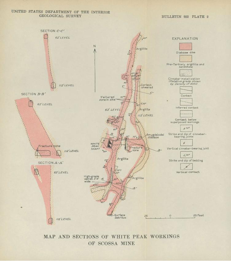
have localized ore shoots (pis. 2, 3, and 4) <> The dikes above
and below the "rolls" are of low grade or are barren.
Inclusions of country rock or splits in the dikes have
also caused the localization of ore shoots in the Scossa and
McAdoo mines (pis. 2 and 4). They have acted as secondary
hanging walls, though in places they are impregnated with
cinnabar.
In the Birthday mine (pi. 5) pre-ore faulting appears to
have controlled the distribution of ore shoots. Here the dike
is broken into segments by faults. Low-grade or barren seg
ments are separated from high-grade segments by faults, which
evidently controlled the flow of mineralizing solutions.229673 O 40 3

14
Size and grade of ore bodies. The ore shoots mined prior
to September 1939 range from a few feet to as much as 60 feet
in length and extend from 5 to 40 feet down the dip. Their
widths range from a foot or less to 8 feet or more. In some
places the ore shoots are bounded by faults, but they generally
grade laterally into rock too low in grade to be mined and
treated.
The ore bodies of the Bottle Creek district are of rela
tively high grade compared with those in most other quick
silver districts in the United States. The ore retorted has
averaged about 30 pounds of quicksilver to the ton, and some
stopes have yielded ore averaging more than 60 pounds. Pre
liminary information furnished by operators in-this district
indicates that with quicksilver at $76 a flask, ore for the
profitable operation of small retorts must contain more than
25 pounds of quicksilver to the ton. A rotary furnace of
30-ton daily capacity may be able to treat profitably ore that
contains from 6 to 8 pounds of quicksilver to the ton. With
an increase in the price of quicksilver and without a corre
sponding increase in commodity prices, obviously ore of lower
grade can be profitably treated.
Reaerves.--At.present the Bottle Creek district possesses*
essentially no blocked-out ore reserves, but its production
record leads to the expectation that systematic prospecting
will disclose additional ore bodies. Present estimates of
their number and their quicksilver content, of course, can
only be speculative, but the following statement may be of
use as an indication of the possible reserves of quicksilver
in the district.
Pour of the diabase dikes have so far been partly ex
plored and have been productive. Three of them are in Ter
tiary (?) rocks and the fourth is in pre-Tertiary rocks.

QUICKSILVER DEPOSITS, BOTTLE CREEK DISTRICT, NEVADA 15
Altogether they are known to contain sporadic cinnabar for a
linear distance of about 3,500 feet, of which only 500 feet
has been developed. Prior to October 1939, 310 flasks of
quicksilver had been produced from workings within 50 feet of
the surface. If it may be inferred that the remaining 3,000
feet of unexplored dikes contains ore bodies of about the
same spacing and grade as those mined, it seems reasonable
that within the area mapped about 1,500 flasks may be re
covered within a depth of 50 feet or less. Although ore la
known to extend to a depth of 112 feet in the district, it is
not possible to predict how much deeper the cinnabar extends.
There are many quicksilver mines in the United States that
contain ore bodies at depths of much more than 100 feet. The
diabase dikes and fault zones in which ore shoots are local
ized in the Bottle Creek district are rather persistent later
ally, and it is probable that both dikes and fault zones have
similar persistence in depth. Thus it seems fair to infer
that ore shoots extend at least two or three times as deep as
the 50-foot depth from which production was derived in 1939.
It is questionable, however, whether the reserves will be
proportionately increased, for the spacing of ore shoots along
the strike may well decrease with increasing depth.»
Ten other diabase dikes were mapped during the examina
tion, chiefly in the western part of the area in both Ter
tiary (?) and pre-Tertiary rocks. None of them, nor any of
the fault zones in rhyolite and in pre-Tertiary rocks, had
been sufficiently explored In the fall of 1939 to provide a
basis for estimation of possible additional reserves that they
might contain. Available evidence, however, suggests that ore
bodies may be found in them. Finally, Tertiary (?) rocks
similar to those exposed In this district crop out to the
south, northeast, and north and may prove to be mineralized.

16 STRATEGIC MINERALS INVESTIGATIONS, 1940
In summary, the Bottle Creek district, though it may
never be as productive as some of the larger California quick
silver districts, is believed to contain appreciable reserves
of quicksilver ore in rather small but high-grade ore shoots,
which because of their apparent localization in diabase dikes
and fault zones, are relatively easy to prospect. A highly
speculative estimate of the reserves, based on a price of $125
a flask, is that the dikes in the area mapped will yield a
minimum of 3,000 flasks of quicksilver at a depth of 150 feet
or less. This minimum may be increased .by additional pros
pecting.
MINES AND PROSPECTS
Mine workings in the district are very Irregular because
for the most part they follow the ore. The levels are num
bered according to their vertical depth below the surface.
The workings are shown as mapped in September 1939.
Scossa mine
The Scossa property, owned by James and Arnold Scossa,
of Winnemucca, consists of two groups of claims the White
Peak Nos. 1, 2, and 3, in the central part of the district,
and the Red Ore Nos. 1, 2, 3, 4, and 5, Red Ore Fraction, and
Red Ore Fraction Nos. 1 and 2 about a mile south of the White
Peak group.
The claims, the first staked in the district, were lo
cated in September 1936. A little assessment work was done
on them in 1936 and early in 1937; and in July 1937 they were
optioned to the Fulton Quicksilver Co., of Reno, Nev. This
company carried on development work including the sinking of
a shaft 112 feet deep on the White Peak No. 1 claim and drift
ing on the 62-foot and 112-foot levels. Several shallow

QUICKSILVER DEPOSITS, BOTTLE CREEK DISTRICT, NEVADA 17
shafts were also put down on the Red Ore group. In 1938 the
claims reverted to the Scossa Bros., who have since further
developed the property. A 30-ton Cottrell furnace was put
into operation in October 1939.
White Peak group. Development work in the White Peak
group shown in plate 2, includes a 112-foot shaft and about
325 feet of drifts and crosscuts. The shaft, in massive rhyo-
lite, passes into a diabase dike and pre-Tertiary arglllite
and sandstone between the collar and the 62-foot level. The
shaft is timbered, so that the contact of rhyollte with ar-
gillite and diabase could not be seen at the time of visit,
but the rhyolite probably overlies argillite and diabase
unconformably. The arglllite in the underground workings
(pi. 2) is commonly massive, but in some places it is finely
laminated. It strikes about N.. 65° E. and dips about 30° SE.
The diabase dike is overlain by rhyolite north of the
mine, but a shallow shaft on the flat 1,300 feet south of
the Scossa shaft is in a basaltic or diabasic rock that may
be the southward extension of the dike. Where seen under
ground the dike ranges from 15 to 17 feet in width but may
be wider at the southern end of the 62-foot level. It is
generally cut by three sets of cinnabar-bearing cracks, one
of which parallels the strike and commonly dips steeply east,
whereas the other two strike transverse to the dike, one set
dipping 30°-90° S. and the other dipping 35°-60° N. The
cracks are widely spaced except where the dike was fractured
by later movement. No faults have been mapped, although the
dike is locally sheared along the walls.
The dike fills an irregular fissure averaging about
N. 10° E. in strike and dipping southeastward. On the 62-

18 STRATEGIC MINERALS INVESTIGATIONS, 1940
except for a 4-foot bulge to the east just north, of the shaft
and a 14-foot bulge south of the shaft where the dike splits«
On the 112-foot level opposite the shaft the hanging wall
bends to the east in a broad "roll".
The ore bodies so far developed appear to be controlled
by the broad "roll" that localized fracturing in the dike.
On the 62-foot level between the point 8 feet north of the
shaft where the dip of the hanging wall decreases and the
point where the drift south of the shaft branches (pi. 2,
sees. B-B 1 and C-C')> ore occurs in the dike along the contact
and in the wedge of argillite. 'No ore had been stoped from
this area when the mine was mapped, but later work showed
high-grade ore extending into the roof between the shaft
and the wedge. Elsewhere on this level cinnabar is chiefly
confined to widely spaced fractures and the hanging-wall con
tact. The ore on the 62-foot level consists of cinnabar,
pyrite locally oxidized, calcite, and chalcedony.
On the 112-foot level the crosscut at a point 17 feet
east of the shaft is traversed by a vertical fracture zone
as much as 2 feet wide. The zone is distinct in the argillite
but appears to die out as it passes upward into the dike
(pi. 2, sec. B-B'). It contains velnlets as much as 4 inches
wide composed of cinnabar interbanded with pyrite, marcasite,
calcite, and chalcedony.
The areas most promising for future development appear
to lie above and below the 62-foot level on the "roll" and
near the argillite wedge.
Red Ore group.--The workings on the Red Ore group con
sist of several shallow shafts, open cuts, and two short adits
in Tertiary (?) diabase dikes and tuffs.

QUICKSILVER DEPOSITS, BOTTLE CREEK DISTRICT, NEVADA 19
The dike on which the Red Ore Fraction No. 2 claim was
located is probably a continuation of the one developed in
the Birthday mine a few hundred feet farther south. It cuts
tuffs of the lower unit of Tertiary (?) rocks and strikes
north and dips 50°-85° W. Cinnabar, iron oxides, and calcite
occur along the hanging wall in the tuff and in the tuff in
clusion on the east side of the drift on the 17-foot level.
Only a little cinnabar was seen in the dike.
Three shafts on Red Ore No. 1 claim are in another dike,
which cuts clays belonging to the upper Tertiary (?) unit. The
dike strikes a little west of north and dips about 60° W. A
few quartz-limonite veinlets containing cinnabar fill cracks
in the dike, and cinnabar occurs along the hanging wall. A
short adit about 200 feet southeast of the shafts has been
driven in tuffs overlain by detrital material that contains
cinnabar nuggets. The largest nugget seen was about half an
inch in its greatest dimension. Presumably the nuggets were
derived from the dike a short distance to the west.
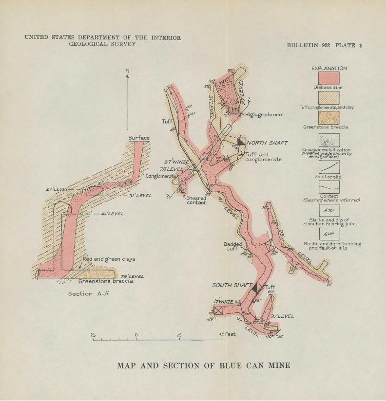
Blue Can mine
The property of the Bottle Creek Mercury Co. known as the
Blue Can or Tin Can mine consists of nine clfeims adjoining the
McAdoo group in the central part of the district. The claims
were located in November 1936 by C. P. Hoskins, T. Smith, and
Thos. C. Niebuhr, of Winnemucca, and are the Blue Can, Blue Can
Nos. 1, 2, 3, 4, 5, and 6, Goodenough, and Bottle Creek Mercury
claims. According to Mr. Niebuhr, the property between
October 11, 1938, and February 5, 1939, produced 40^ flasks of
quicksilver in a two-tube retort from ore averaging 32 pounds
of quicksilver to the ton. The property was sold to James 0.
Greenan, of Reno, Nev., in February 1939 who has since been

20 STRATEGIC MINERALS INVESTIGATIONS, 1940
carrying on development work. In the course of sampling
operations five flasks of quicksilver was produced in November
and December 1939.
The underground workings in September 1939 included a.
40-foot shaft, a 37-foot shaft, a 37-foot winze, and about
500 feet of raises, drifts, and crosscuts.
The workings (pi. 3) are in a diabase dike cutting the
tuffs and conglomerate of the lower Tertiary (?) unit, which
here strike N. 10°-40° W. and dips 25°-35° SW. The tuffs as
seen underground are massive to well-bedded and are commonly
fine-grained, with local pebbly layers. Conglomerate forms
the hanging wall locally between the 27- and 41-foot levels;
it contains boulders as much as 6 inches in diameter in a
clayey matrix. An altered greenstone breccia in the crosscut
east of the winze on the 78-foot level is probably part of the
pre-Tertiary series. The breccia is overlain by red and green
clays that are in contact with the footwall of the dike.
The dike is traceable on the surface by float for about
1,800 feet north and 1,300 feet south of the North shaft of
the Blue Can mine (pi. 1). In the underground workings north
of the South shaft the strike averages about N. 30° W. and
dips southwest, but west of the South shaft the hanging wall
swings to the northeast. The width ranges from 3 feet in the
south end of the 27-foot level to more than 20 feet just
south of the South shaft. Cinnabar-bearing cracks in the dike
were mapped only where they are systematic; in most places the
joints are unsystematic.
Near the North shaft (pi. 3, sec. A-A') the dike is al-*
most vertical from the surface to the 27-foot level; at the
27-foot level it "rolls" abruptly and is horizontal for about
10 feet, follows beds dipping 25°-35° W. for a distance of
about 20 feet, and then steepens to a dip of about 70° at the
UNITED STATES DEPARTMENT OF THE INTERIOR GEOLOGICAL SURVEY BULLETIN 922 PLATE 2
SECTION C-C'\
[SJ 62'LEV EL
112'LEVEL
SECTION B-B'
' ?.] 62'LEVEL
Fracture ̂ zone
112 LEVEL
SECTION A-A'
62LEVEL
EXPLANATION
3'altered zone in dike
High-grad vein let 2-wide
112'LEV EL
mvgdaloidal Strike and dip of cinnabar- HiaBase bearing joints
Vertical cinnabar-bearing joint
WHITE: PEAK ! ^SHAFT
"5.5'
25 Feet
MAP AND SECTIONS OF WHITE PEAK WORKINGSOF SCOSSA MINE
UNITED STATES DEPARTMENT OF THE INTERIOR GEOLOGICAL SURVEY BULLETIN 922 PLATE 3
N EXPLANATION
Red and green clays
/, /'' Greenstone breccia
Section A-X
MAP AND SECTION OF BLUE CAN MINE

UNITED STATES DEPARTMENT OF THE INTERIOR GEOLOGICAL SURVEY BULLETIN 922 PLATE 4
EXPLANATION
N
NORTH Cinnabar metallization
xJ" Vertical contact
MAP AND SECTIONS OF MCADOO MINESections show interpretative geology not shown on plan
UNITED STATES DEPARTMENT OF THE INTERIOR GEOLOGICAL SURVEY BULLETIN 922 PLATE 5
N
A
SECTION A-A'
'L, /
K'Jj IS'LEYEL
SECTION B-B'
SECTION C-C'
'l\.& LEVEL
NORTH SHAFT
CENTRAL SHAFTSurface
18'LEV EL
'44 LEVEL
EXPLANATION
Vertical fault
c'CENTRAL SHAFT
Altered and sheared diabase impregnated
SOUTH SHAFT
Cinnabar, pyrite and carbonate in basalt ordiabase
25 25 Feet
MAP AND SECTIONS OF BIRTHDAY MINE

QUICKSILVER DEPOSITS, BOTTLE CREEK DISTRICT, NEVADA 21
41-foot level... The "roll" extends southward at least as far
as the south end of the 25-foot level. Below the 41-foot
level the dike dips steeply, but the dip decreases to about
30° just above the 78-foot level. Several faults of apparent-
ly small displacement cut the dike. Movement on them was in
part post-ore, for cinnabar is locally smeared out on slicken-
sided surfaces.
The ore is confined to the dike and immediately adjacent
wall rocks. The ore shoots are controlled by the "rolls"
where the dike has a low-angle dip and is more minutely frac
tured. As in the Scossa mine the ore of highest grade lies
along the hanging wall except in the stope on the 27-foot
level, where the dike is only 3 feet thick and is mineralized
throughout.
The stopes on the 27- and 31-foot levels yielded ore re
ported to contain as much as 127 pounds of quicksilver to the
ton. In the walls of these stopes cinnabar, iron oxides, cal-
cite, and chalcedony fill vertical cracks that strike north
and east within the dike. The cracks are closely spaced in
this part of the mine, and some contain veinlets of solid
cinnabar as much as a quarter of an inch thick.
No ore had been stoped from the 25-foot level at the time
of visit, but in the west crosscut high-grade ore occurs along
the hanging wall and in the adjacent tuffs. The dike in the
drift contains local high-grade spots and a little cinnabar
on joints. Its hanging wall is not exposed.
The drift on the 41-foot level follows the hanging wall
of the dike, which dips steeply where seen and appears to
contain only low-grade material except in the area west of
the North shaft.

22 STRATEGIC MINERALS INVESTIGATIONS, 1940
The dike in the winze to the 78-foot level is mineral
ized, and the part along the hanging wall may constitute ore«
High-grade bunches occur along the hanging wall in the short
drift on the 78-foot level. The hanging-wa11 conglomerate is
locally cut by cinnabar veinlets for a distance of about a
foot from the contact.
Although only a little ore had been blocked out at the
time the property was examined, several areas underground ap
pear to warrant investigation. One of these lies on the 27-
and 25-foot levels along the hanging wall to the north and
south of the present workings. Another is along the hanging
wall on the 78-foot level just above the level. On the basis
of showings on the 78-foot level, further exploration appears
warranted,.
McAdoo mine
The McAdoo property comprising 25 claims is owned by Dr.
W. C. McAdoo, of Winnemucca. One group, including the Blue
bird Nos. 1, 2, 3, 4, and 5, Bluebird Fraction, Fraction,
Anthill, and Rainbow Fraction Nos. 2 and 4, is in the central
part of the district. The Anthill No. 1, Red Ore Extension,
Blue Eagle Nos. 1 and 2, Pickup Nos. 1, 2, and 3, Tiger Nos.
1, 2, 3, and 4, and Standard Nos. 1, 2, and 3 claims are
scattered throughout the southern and eastern parts of the
district.
The discovery was made on the Bluebird No. 3 claim by
Dr. McAdoo in September 1936, and the discovery shaft was
sunk 6 months later. Some of the claims were under option to
the Fulton Quicksilver Co., of Reno, Nev., during part of
1937 and 1938, but the option was released. A two-tube re-

23
tort-was put Into operation in May 1939, and four more tubes
were added in July 1939. One hundred and fourteen flasks of
quicksilver had been produced by October 19, 1939.
The underground workings (pi. 4) in September 1939 in
cluded two inclined shafts and about 300 feet of drifts,
crosscuts, and raises. Most of the underground work has been
done on the 20-foot and 52-foot levels.
The workings are In a continuation of the dike developed
In the Blue Can mine, about 200 feet to the south (pi. 1).
The dike cuts the lower Tertiary (?) unit, which here strikes
north and dips 20°-30r W. In this unit a continuation of the
conglomerate bed mapped in the Blue Can mine forms the hang-
Ing wall of the dike south of the North shaft between the 20-
and 31-foot levels; elsewhere in the mine tuffs form the
hanging wall. The footwall rocks include clays, tuffs, and
conglomerate.
The dike strikes northward and dips westward. On the 20-
foot level north of the North shaft it strikes about N. 15° W.
and dips steeply southwest. South of this shaft its strike
swings to about N. 10° E. and its dip is steeply northwest as
far as the branch in the 20-foot level. At this branch the
dike flattens and is nearly horizontal on the 22-foot level.
Between the 22- and 31-foot levels it again steepens, dipping
45°-60° W.
The dike ranges in width from 4 feet at one place on the
52-foot level to more than 10 feet on the 20-foot level. In
most places there are four sets of cinnabar-bearing cracks:
two sets parallel the strike of the dike and dip to the east
and west; the other two are transverse to the dike and dip
north and south. Several small faults were mapped, and con
tacts between dike and wall rock are locally sheared.

fcf' '"'"'''
24 STRATEGIC MINERALS INVESTIGATIONS, 1940
The ore, which is confined almost entirely to the dike,
extends from the 31-foot level to the North shaft along the
hanging wail. Several structural features appear to have
controlled fracturing, which localized the ore. The most ef
fective.is the "roll" in the dike, which apparently followed
bedding and fractures in the sedimentary rocks between the
20- and 30-foot levels. Another is the wedge of tuff and con
glomerate at the point where the 20-foot level branches; and
still another is the steplike hanging wall between the wedge
and the North shafto The dike in general is more minutely
fractured along the hanging wall than elsewhere. The fault
on the south side of the 22- and 26-foot levels may have also
aided in controlling mineralization, for only a little cinna
bar is found in the dike south of ito
The ore body in the "roll" between the 31-foot level and
the point where the 20-foot level branches is from 2 to 8
feet thick and 4 to 15 feet wide and extends down the dip for
more than 40 feet. The ore is oxidized and consists of cin
nabar, iron oxides, calcite, and chalcedony filling closely
spaced fractures. Throughout most of the stope the ore is re
ported to have averaged between 40 and 60 pounds of quicksil
ver to the ton and locally to have contained as much as 80
pounds to the ton.
The wedge of tuff and conglomerate that splits the dike
at the east side of the "roll" projects downward into the dike
about 3 feet below the 20-foot level. It is mineralized in
some places, and high-grade ore occurs in the adjacent dike.
From this wedge to the North shaft ore said to have averaged
55 pounds of quicksilver to the ton was stoped along the
hanging wall. The ore extended about halfway across the drift
in this area.

QUICKSILVER DEPOSITS, BOTTLE CREEK DISTRICT, NEVADA 25
The drift north of the North shaft disclosed a little
cinnabar along the contact of the dike and in the adjoining
tuffs. No ore had been stoped from this area at the time of
visit.
Although the dike is irregular on the 52-foot level, only
a little cinnabar was seen. Joints at the bottom of the shaft
and near the raise are mineralized, but elsewhere the dike and
tuffs are barren.
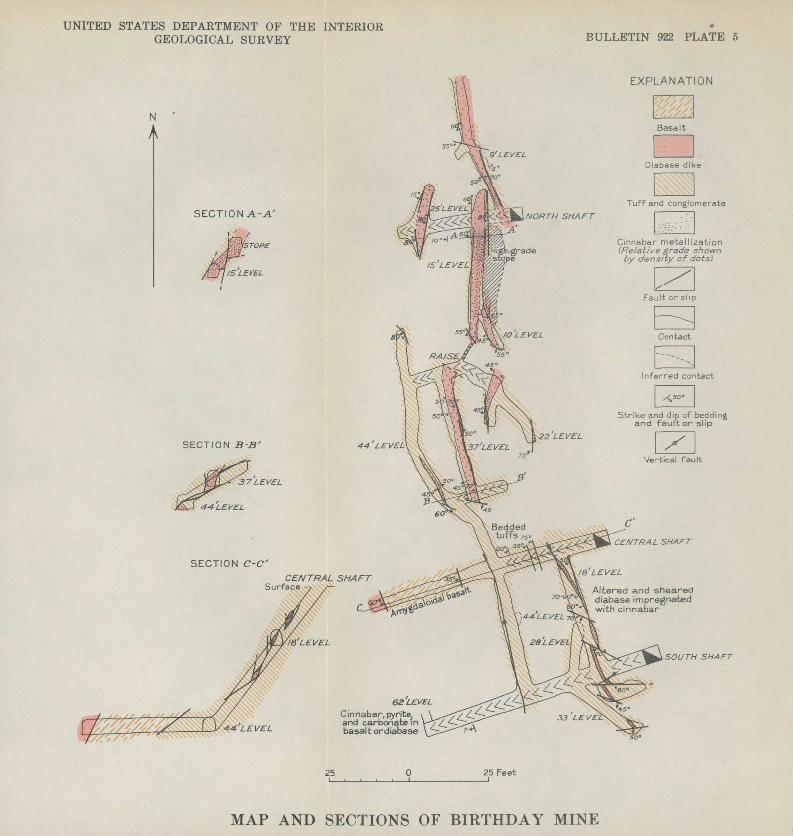
Birthday mine
The Birthday mine is owned by D. J. Wootan, M. S. McCown,
G. Wootan, and Mo Wootan. The property includes eight claims',
of which the Birthday, Birthday No. 1, Lone Star Fraction,
Mercury King, Amador, and Perhaps claims are in one group in
the southwestern part of the area mapped. The Last Chance and
Hector claims, in the central part of the district, adjoin the
Scossa White Peak group.
The claims were located in October 1936 by D. J. Wootan.
Ore was discovered on the Birthday claim in June 1938, and the
North shaft was sunk soon afterward. A two-tube retort was
put into operation in September 1938, and two more tubes were
added in September 1939o The property produced 47 flasks of
quicksilver in 1938 from a two-tube retort, and 165 flasks in
1939, when two tubes were operated until September 15 and four
tubes thereafter.
The Birthday claim is now developed by three Inclined
shafts, the North shaft 56 feet deep, the Central shaft 57
feet deep, and the South shaft 100 feet deep. About 400 feet
of crosscuts, raises, and drifts had been driven when the
property was mapped. The workings are In a faulted diabase
dike that cuts tuffs of the lower Tertiary (?) unit and the
overlying basalt. These rocks strike north and dip 10°-25° W.

26 STRATEGIC MINERALS INVESTIGATIONS, 1940
The tuffs and basalt have been intensely sheared and altered
in most places. Another dike where seen in the crosscut east
of the Central shaft was not mineralized.
The mineralized dike is less than 10 feet wide in the
workings. Commonly one or both of its walls are faulted. It
strikes north to N. 20° W. and dips 45°-50° W. Where intensely
faulted and mineralized the dike is altered. Its feldspars
have been changed to clay minerals and its original dark min
erals have been so thoroughly leached that the rock resembles
the enclosing.tuffs.
The ore bodies, which are confined to the dike and adja
cent wall rocks, appear to have been controlled by faults or
slips, which may be divided into three groups: two of them
are commonly parallel with the dike and strike north to N. 20°
W., one dipping steeply east and west and the other dipping
gently west; the third group strikes N. 45° W. to west and
generally dips steeply southwest. Single faults are commonly
curved, and in places faults of one group curve and join those
of another group. The faults are generalized on plate 5<>
Displacement along individual faults appears to be small, but
the aggregate movement has caused the dike to be broken into
segments that lens out along the strike and down the dip.
Faulting has been most intense in the southern part of the
workings. The faults were probably formed at the time when
the major faulting separated Tertiary (?) and pre-Tertiary
rocks a few hundred feet to the west. They represent readjust
ments in the downthrown block. Some movement took place after
ore deposition, however, for cinnabar is locally smeared out
on slickensided surfaces.
The ore shoots are commonly limited by faults. The larg
est shoot mined was south of the North shaft on the 15-foot
level (pi. 5., sec. A-A')« Here ore was stoped for 32 feet

QUICKSILVER DEPOSITS, BOTTLE CREEK DISTRICT, NEVADA 27
along the drift from a block 3 to 4 feet by 6 to 12 feet in
cross section. The dike is offset a few inches by two slips
that dip gently to the west. The ore mined was of high grade,
containing as much as 60 pounds of quicksilver to the ton.
The dike on the 37-foot level yielded a little ore from
sheared and faulted lenses in the roof. A high-grade lens
about 10 feet long was mined on the 22-foot level. Three
small lenses (pi. 5, sec. C-C 1 ) were disclosed in the Central
shaft. None of them have been stoped.
The lenses on the 18-foot level were small but of high
grade. -Altogether five lenses, ranging from 2 to 16 feet in
length and commonly less than 3 feet in width, were stoped.
One extended down to the 28-foot level, but the others were
confined to the 18-foot level.
At the time the mine was mapped ore was found in the
South shaft on the 62-foot level about 100 feet down the in
cline. Here the ore occurs in a sheared basaltic or diabasic
rock, but, as the shaft is timbered, the relation of this
rock to the tuffs could not be determined. The ore zone is
as much as 2 feet wide and is faulted on both sides.
The cinnabar is accompanied by pyrite, calcite, and chal
cedony. The ore is oxidized down to the 44-foot level. The
minerals fill vesicles and fractures in the diabase and lo
cally Impregnate the diabase and adjacent tuffs.
Although the ore bodies are small and are much faulted,
exploration to the south between the 18- and 62-foot levels
and to the north between the 44- and 62-foot levels seems
warranted.

28
The Baldwin .group of 12 claims in the eastern part of the
district includes the Blue Bucket, Blue Bucket Nos, 1, 2, 3,
and 4, Blue Bucket Fraction, Blue Bucket Fraction No. 1, Black
Beauty, Senator, Senator No. 1, Apex, and Sunflower claims.
They are owned by H. W. Baldwin, of Winnemucca, and the estate
of John C. Duryea and were located in September 1936. For a
time in 1937-38 they were under option to the Fulton Quick
silver Co., of Rem>, but the option was released. In December
1939 the group was optioned to James 0. Greenan, of Reno, who
has since been carrying on development.
The workings, chiefly on Blue Bucket Nos. 1 and 3 claims,
consist of a 28-foot shaft and a connecting drift and a short
adit, all in rhyoliteo
The shaft is in a flow-banded rhyolite that is locally
sheared and brecciated. The most prominent breccia zone
strikes N. 55° E. and dips 80° SE. and is as much as li feet
wide.. Cinnabar, accompanied by chalcedony, calcite, and a
little pyrite, occurs in and adjacent to the breccia zones,
filling spaces around rhyolite fragments and locally replacing
the fragments.
Two faults trending N. 75° E. and dipping steeply south
east were mapped in the adit about 50 feet southeast of the
shaft. A little cinnabar was noted on fractures in the rhyo
lite between the faults.
Further exploration since the property was visited has
disclosed ore in rhyolite about 300 feet southeast of the6/
shaft. The ore is said to average about 25 pounds of quick-
6/ Baldwin, H. W., and Donaldson,'W. G., personal communication.

QUICKSILVER DEPOSITS, BOTTLE CREEK DISTRICT, NEVADA 29
silver to the ton over a width of 10 feet. A specimen sent
to the writer shows cinnabar in a silicified and brecciated
flow-banded rhyolite.
Niebuhr mine
The Niebuhr property, owned by T. C. Niebuhr, of Winne-
mucca, is in the northwestern part of the district near the
common corner of Tps. 40 and 41 N. , Rs,, 32 and 33 E. It con
sists of seven claims: Sun-Set, Sun-Set Nos. 1 and 2, Big
Four, Big Pour No. 1, Alice Bell, and Alice Bell No. !<, Cin
nabar was discovered on the Sun-Set claim In March 1939. No
quicksilver had been produced at the time of visit, but Mr.
Niebuhr reports that a two-tube retort was installed and a
flask of quicksilver was produced from about 5 tons of ore
treated in January 1940.
The workings on the property at the time of visit in
cluded a 17-foot shaft and several open cuts. The shaft, in
massive rhyolite, is traversed by a fault zone 2 to 3 feet
wide that strikes about N. 55° E. and dips 65° SE. Cinnabar
coats rhyolite fragments in the fault zone and locally im
pregnates the finely crushed matrix. According to Mr.
Niebuhr, solid cinnabar "bunches" weighing as much as 2 pounds
have been found in the fault zone,,
In an open cut about 1,400 feet northwest of the shaft
phyllite striking N. 55° W. and dipping 25° NE. is cut by a
fault zone striking about N. 60° W. and dipping 70°-90° SWo
Cinnabar accompanied by iron oxides occurs in the fault zone
and in adjacent cracks and on cleavage planes.
A diabase dike that crops out about 100 feet oast of the
open cut (pi. 1) was traced for about 400 feet to the north
and about 3,500 feet to the south of the open cut. Inasmuch
as this dike occurs close to the fault zone, it warrants ex
ploration.
O