strategy for the restoration of the waterways of the merri
TRANSCRIPT

State of the Environment Report
i
EXECUTIVE SUMMARY
There is a growing focus in the community on restoration of urban and other areasdamaged by human actions. We want to clean up the environment close to where we live- our air, our open spaces, and our water.
This study examines the potential for restoration of one such damaged system - thewaterways of the Merri Catchment, in Melbourne’s northern suburbs. The Merri Creekrises in the foothills of the Great Dividing Range near Wallan, approximately sixtykilometres north of Melbourne, and flows south, through rural, industrial and residentialareas to its confluence with the Yarra River near Dights Falls in the inner city suburb ofAbbotsford. The Merri Creek itself is approximately 80 kilometres long and thecatchment drains an area of approximately 400 square kilometres.
This study presents all the available information on the state of the waterways of theMerri Catchment. It identifies, as far as possible, the problems resulting from humanactivities.
Throughout the study the principles of Integrated Catchment Management have beenused, in particular the concepts of:
• recognition of the intrinsic worth of the natural environment
• an interdisciplinary approach and a systems perspective
• concern to include community values
• an integrated environmental and socio-economic approach
The most important findings of the State of the Environment Report are that:
• Agricultural practices - such as removal of riparian vegetation, drainage of wetlandsand stock trampling of stream banks - are a major cause of aquatic ecosystemdegradation.
• Urban development has massively altered the flow and the water quality of thewaterways, for example by increasing the quantity of stormwater which carries a highload of contaminants.
• Sewage treatment in the catchment is inadequate, with effluent from CraigieburnSewage Treatment Plant and from unsewered industrial and residential areascontributing significantly to the nutrient problem in some parts of the MerriCatchment.
• Industrial activities still pollute the waterways - mainly from inadequate storage,disposal and transport of materials such as chemicals.
• Despite these obvious problems, there are still long stretches of the Merri Creek thathave National, State, Regional or Local biological significance, with survivingremnant populations of increasingly rare species such as the Growling Grass Frog,Freshwater Blackfish and Rufous Night Heron and habitats such as the endangeredWestern (Basalt) Plains Native Grassland.
• There is strong community support for waterway restoration.

Waterways of the Merri Catchment
Page ii
State of the Environment Report
iii
Table of Contents
1. INTRODUCTION ...................................................................................................9
1.1 The Merri Creek and its Catchment....................................................................................................... 9
1.2 Background to the Report...................................................................................................................... 10
1.3 The Merri Creek Management Committee .......................................................................................... 12
1.4 Monash University Master of Environmental Science ........................................................................ 12
1.5 Methodology and Methods..................................................................................................................... 13
1.6 Structure of this Report ......................................................................................................................... 15
1.7 A Journey down the Merri Creek ........................................................................................................... 2
2. THE HUMAN ENVIRONMENT............................................................................11
2.1 Introduction............................................................................................................................................... 92.1.1 Previous work...................................................................................................................................... 9
2.2 Changes in Human Use since Settlement.............................................................................................. 122.2.1 Introduction ....................................................................................................................................... 122.2.2 Agriculture ........................................................................................................................................ 122.2.3 Industrialisation................................................................................................................................. 142.2.4 Urbanisation ...................................................................................................................................... 16
2.3 Current Community Attitudes and Uses .............................................................................................. 20
2.4 Agencies and Institutions ....................................................................................................................... 232.4.1 The Players........................................................................................................................................ 23
2.5 Legislation, Strategies and Policies ....................................................................................................... 292.5.1 The Environment Protection Act 1970 (Vic.) ................................................................................... 292.5.2 Other State legislation ....................................................................................................................... 342.5.3 Commonwealth strategies, legislation and policies........................................................................... 35
2.6 Current Arrangements .......................................................................................................................... 36
2.7 Conclusions.............................................................................................................................................. 37
3. GEOMORPHOLOGY AND FLOW ......................................................................45
3.1 Introduction............................................................................................................................................. 433.1.1 Previous work.................................................................................................................................... 43
3.2 “Natural” states ...................................................................................................................................... 45
3.3 Existing states.......................................................................................................................................... 453.3.1 The Merri Creek ................................................................................................................................ 463.3.2 Summaries of the Significant Tributaries.......................................................................................... 503.3.3 Wetlands............................................................................................................................................ 543.3.4 Water Harvesting .............................................................................................................................. 55

Waterways of the Merri Catchment
Page iv
3.3.5 Stormwater ........................................................................................................................................ 553.3.6 Floods ................................................................................................................................................ 583.3.7 Groundwater...................................................................................................................................... 59
3.4 Conclusions.............................................................................................................................................. 60
4. WATER QUALITY...............................................................................................67
4.1 Introduction............................................................................................................................................. 714.1.1 Previous Work................................................................................................................................... 714.1.2 Scope of this section.......................................................................................................................... 73
4.2 ‘Natural’ states ........................................................................................................................................ 73
4.3 Water quality parameters as indicators of stream health ................................................................... 74
4.4 Existing states .......................................................................................................................................... 744.4.1 Physical and chemical parameters ..................................................................................................... 744.4.2 Biological Parameters........................................................................................................................ 874.4.3 Groundwater quality.......................................................................................................................... 91
4.5 Conclusions.............................................................................................................................................. 96
5. AQUATIC ECOLOGY..........................................................................................99
5.1 Introduction............................................................................................................................................. 965.1.1 Previous work.................................................................................................................................... 965.1.2 Scope of this section.......................................................................................................................... 97
5.2 ‘Natural’ states ........................................................................................................................................ 98
5.3 Existing states .......................................................................................................................................... 985.3.1 Streams ............................................................................................................................................ 1005.3.2 Wetlands.......................................................................................................................................... 1005.3.3 Riparian Vegetation and Aquatic Plants in the Merri Catchment.................................................... 1015.3.4 Micro-organisms.............................................................................................................................. 1035.3.5 Invertebrates .................................................................................................................................... 1035.3.6 Fish .................................................................................................................................................. 1045.3.7 Reptiles and Amphibians................................................................................................................. 1085.3.8 Water Birds...................................................................................................................................... 1105.3.9 Aquatic Mammals............................................................................................................................ 113
5.4 Conclusions............................................................................................................................................ 114
6. REPORT CONCLUSIONS ........................................ Error! Bookmark not defined.
7. REFERENCES .......................................... ERROR! BOOKMARK NOT DEFINED.
8. APPENDICES ................................................................................................... 119
State of the Environment Report
v
List of MapsMap 1 The Waterways of the Merri Catchment ________________________________________ 11
Map 2 Land-use types in the Merri Catchment _________________________________________ 19
Map 3 Merri Creek Catchment and Municipal Boundaries _______________________________ 26
Map 4 Reaches of the Merri Creek __________________________________________________ 48
Map 5 Drains to the urban waterways of the Merri Catchment ____________________________ 57
Map 6 Sediment sampling sites 1995 heavy metal study. _________________________________ 76
Map 7 Location of landfills in the urban portion of the Merri Catchment. ___________________ 89
Map 8 Zoning of the Merri waterways according to the distribution of habitat, flora and fauna___ 99
List of FiguresFigure 1 Runoff hydrographs for different percentages of urbanisation of a catchment__________ 56
Figure 2 Concentration of metal in sediments downstream along Merri Creek ________________ 78
List of BoxesBox 1 Impacts of Agriculture on Waterways ___________________________________________ 11
Box 2 Impacts of Industrial Activity on Waterways _____________________________________ 15
Box 3 Impacts of Urbanisation on Waterways _________________________________________ 16
Box 4 Community Consultation Report ______________________________________________ 21
Box 5 State environment protection policy ____________________________________________ 29
Box 6 SEPPs affecting the Merri Catchment___________________________________________ 30
Box 7 EPA Licences to Discharge Waste to Water ______________________________________ 32
Box 8 Rates of Change in the Merri Catchment_________________________________________ 44
Box 9 Water Quality Indicators_____________________________________________________ 68
Box 10 Biological Indicators of Stream Health _________________________________________ 83
Box 11 Human influences on waterbirds _____________________________________________ 111
Waterways of the Merri Catchment
Page vi
List of TablesTable 1 EPA Water Discharge Standard for Craigieburn STP as from September 1993 ______ 23
Table 2 Summary of Key Pollutants from Human Activities _____________________________ 19
Table 3 Extractive Industry Discharge Licences______________________________________ 33
Table 4 Sewage & Sullage Wastewater Discharge Licences ____________________________ 33
Table 5 Overview of surveys examining geomorphology and flow in the Merri______________ 39
Table 6 Overview of surveys examining water quality in the Merri Catchment. _____________ 61
Table 7 Water Quality Parameters as Indicators _____________________________________ 71
Table 8 Biological Indicators of Organic Pollution ___________________________________ 84
Table 9 A summary of the average chemistry from 105 bores in the Merri Catchment ________ 86
Table 10 A summary of the average chemistry from 67 bores in the upper portion of the MerriCatchment_____________________________________________________________ 86
Table 11 A summary of the average chemistry from 38 bores in the lower portion of the MerriCatchment. ____________________________________________________________ 86
Table 12 Landfill sites and reclaimed quarries and type of landfills in the urban portion of theMerri Catchment _______________________________________________________ 88
Table 13 Evaluation of Pollution issues against SEPP__________________________________ 92
Table 14 Overview of flora and fauna surveys in the Merri Catchment _____________________ 93
Table 15 Fish in the Merri Catchment and their environmental requirements_______________ 106
Table 16 Reptiles and Amphibians in the Merri Creek _________________________________ 109
Table 17 Distribution of waterbirds in Merri Catchment _______________________________ 112
Table 18 Sites at which the Water Rat was found in the Merri Catchment__________________ 114

State of the Environment Report
vii
Appendices Referred to in the Report
Appendix 1 State Environment Protection Policy W-29 ______________________________ 119
Appendix 2 State Acts other than the Environment Protection Act (1970).________________ 120
Appendix 3 Other Commonwealth Acts and Strategies _______________________________ 121
Appendix 4 Summary of monitoring programmes and reports analysing the water quality of theMerri Creek. ______________________________________________________ 122
Appendix 5 Mean concentrations (mg/kg dry weight) of heavy metals in sediments (<62 mm sizefraction) collected in April 1995. ______________________________________ 132
Appendix 6 A summary of existing Sediment Guidelines (in mg/kg) from overseas _________ 132
Appendix 7 Rock shale standard - as a measure of background sediment concentrations ____ 132
Appendix 8 Concentrations (mg/kg dry weight) of heavy metals associated with each sedimentphase (August 1995). _______________________________________________ 133
Appendix 9: Percentage of total metal concentration associated with each sediment fraction (Aug1995)____________________________________________________________ 134
Appendix 10 Adsorption of zinc to Merri Creek sediment (Barry Road)___________________ 137
Appendix 11 Summary of guidelines for protection of aquatic ecosystems_________________ 138
Appendix 12 Descriptions of the Riparian and In-stream Vegetation of Merri Creek and some ofits Wetlands and Tributaries. _________________________________________ 142
Appendix 13 General Descriptions of Vegetation types in the Merri Creek Catchment _______ 145
Appendix 14 Fish in the Merri Catchment__________________________________________ 147
Waterways of the Merri Catchment
Page viii
Acknowledgments
A number of people have provided valuable assistance and advice throughout this project,which has been greatly appreciated:
Our supervisors:Paul Bishop Graduate School of Environmental Science, Monash University (Clayton).Barry Hart CRC for Freshwater Ecology, Monash University (Caulfield).D.C. “Bear” McPhail Department of Earth Sciences, Monash University (Clayton).David Mercer Department of Geography, Monash University (Clayton).
The staff at the Merri Creek Management Committee, in particular:Rod McLellan Manager.Tony Faithfull Conservation Planning OfficerJanine Lawrie Environmental Education OfficerFreya Merrick Water Quality Research Officer
The participants in group discussions and meetings:Sandra Brizga Consultant.Peter Christoff Department of Politics, University of Melbourne.Neil Craigie Consultant, N.M. Craigie & Associates.Gordon Davies Director, Catchment & Drainage Division, Melbourne Water.Lisa Dixon Freshwater Studies, EPA.Simon Fell Community StreamWatch Coordinator, MPW.Anne Graesser Senior Environmental Scientist, MPWTrevor Hausler Friends of Merri CreekTony Ladson Department of Engineering, University of Melbourne.Vin Pettigrove Manager, Waterways & Drainage Division, MWCNick Ronan Manager, Waterways & Drainage Division, MWCMax Sargent Friends of Merri CreekDavid Taylor Friends of Merri CreekKerry Wailes Environmental Officer, City of WhittleseaTerry White Consultant, Community StreamWatch.
Other people who have provided information at various stages.Chris Chesterfield MPW.Russell Costello EPA, Senior Project Officer.Kevin Dawson Yarra Valley Water.Anne Devereaux EPA, Yarra Region.Kathryn Fergusson EPA (NSW).David Hebblethwaite EPA, Yarra Region.John Koehn Freshwater Fish Management Branch, Arthur Rylah Institute.Phil Mitchell WaterEcoscience.Bill O’Connor Freshwater Fish Management Branch, Arthur Rylah Institute.Horrie Poussard YarraCare.Nick van Roosendael Plantiwise Nursery, Mernda.Melody Serena Australian Platypus Conservancy.Andy Shugg Grounderwater Management & Protection, DNRE.Don Williams EPA, Yarra Region.Allan Webster DNRE, Melbourne region.
State of the Environment Report - Human Environment
9
State of the Environment Report
This report summarises the current state of knowledge about the waterways of the MerriCatchment.
This report has been produced for and with the assistance of the Merri Creek ManagementCommittee (Inc.). It is based on a document produced by the authors as a course requirementof the Monash University Masters of Environmental Science degree.
1. Introduction
This report presents a State of the Environment Report on the aquatic ecosystem of the MerriCatchment. It is intended to;
• provide a summary of the current state of knowledge about the waterways of the MerriCreek catchment, in terms of human influences, water quality, flow, geomorphology andaquatic ecology
• highlight the most important factors causing degradation.
This report is designed to be a source of reference material for anyone involved in managingthe Merri Catchment, or simply with an interest in these waterways. It also presents anessential requirement towards the production of an integrated management plan for the MerriCatchment. It is vital to ensure that a common understanding about the interacting processeswithin the system is developed between agency staff, stakeholders and the broadercommunity.
Over the past few decades the Merri Catchment has been the subject of a considerablenumber of studies relative to many other urban Australian streams. In particular, the MerriCreek Management Committee (MCMC) has worked with Melbourne Water to produce aseries of reports on the catchment. Other agencies, such as the Department of NaturalResources and Environment and Environment Protection Agency, as well as variousindependent consultants have also collected and presented data. However, this informationhas never before been condensed and analysed in one document specifically relating to theCatchment’s waterways.
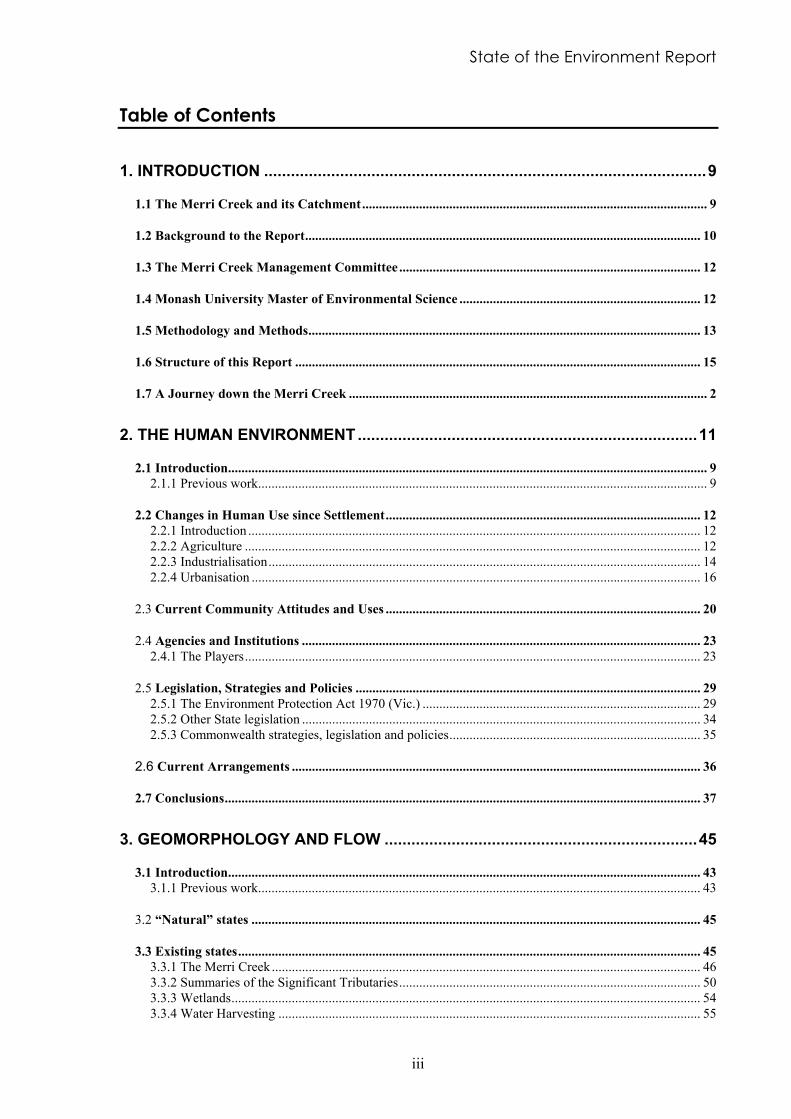
1.1 The Merri Creek and its Catchment
The Merri Creek rises in the rural foothills of the southern Victorian portion of the GreatDividing Range near Wallan, approximately sixty kilometres north of Melbourne, and flowssouth to its confluence with the Yarra River near Dights Falls in the inner city suburb ofAbbotsford. The Merri Creek itself is approximately 80 kilometres long and the catchmentdrains an area of slightly less than 400 square kilometres.
The upper three quarters of the catchment is predominantly rural, the lower quarterpredominantly residential and urban. The large town of Craigieburn is situated midwayalong the Merri Creek, a little further downstream is the dense industrial area around
Waterways of the Merri Catchment
Page 10
Somerton, Campbellfield and Thomastown and further south are the outer suburbs ofMelbourne.
Although the Merri Creek itself is the main watercourse in the catchment, a number oftributaries join the Merri Creek and are an important part of the Merri Catchment (see Map1). The major tributaries are; Malcolm Creek which is in a predominantly rural area andjoins the Merri Creek in Somerton, Kalkallo Creek which draws water off the hills west ofBeveridge flowing southward to join the Merri Creek near Donnybrook Road, MerlynstonCreek which joins the Merri Creek in urban Fawkner and Edgars Creek, the largest tributary,which flows through rural, industrial and urban land before joining the Merri Creek inPreston.
The headwaters of the Merri Creek are in an area of mostly Silurian sedimentary rocks.Further downstream the streams of most of the Merri Catchment flow through areas ofNewer Basalts. In its lower reaches Edgars Creek also flows through areas of Siluriansedimentary rock (Mitchell & Dunn, 1993).
1.2 Background to the Report
The Merri Creek has been the subject of recent efforts to return it to a more “natural” state.The creek is affected by the whole range of issues associated with agricultural, industrial andresidential land use. Concerns in the community about degradation of the creek and itssurrounding parklands arising from increased urban development led to the founding of theMerri Creek Management Committee (MCMC) in 1989. The MCMC is an independentadvisory and managerial body with representatives from local and State Government and thelocal community and is funded by member agencies. The committee has developed a conceptplan to improve the creek, which states as its vision;
To achieve a healthy living stream flowing through an attractive bushland environment whichprovides habitat for native animals and is valued by the community as a peaceful, passive openspace haven. To protect the natural and cultural features of the Merri Creek corridor throughsensitive management which will provide a lasting benefit for the community. (MPW, 1994)
The local community of the Merri Creek has already communicated its support for restorativework on the creek. In a 1992 survey conducted of 417 local residents, water quality of thecreek was ranked as the most important feature of the parklands requiring attention (MCMC,1993).
Through the concerted efforts of the MCMC, state government agencies, local governmentand members of the community, much work has already been done to restore sections of theMerri Catchment. In particular, a great deal of work has been carried out to increase the sizeand quality of parklands along the Merri Creek by re-establishing native vegetation.However, little work has been carried out to date to restore the aquatic or instream area of thewaterways of the catchment.

State of the Environment Report - Human Environment
11
Map 1 The Waterways of the Merri Catchment

Waterways of the Merri Catchment
Page 12
1.3 The Merri Creek Management Committee
The Merri Creek Management Committee Inc. (MCMC) was established in 1989 bylocal community groups, local councils and the State Government. It carries out restorationand education work in the Merri Catchment, particularly of the urban reaches of the MerriCreek. It aims to provide a new model for urban creek management.
In addition to carrying out revegetation work along the creek parklands, the MCMC alsocarries out various education programs in the catchment, such as a recent project with markettraders to reduce the amount of litter entering stormwater drains, production of materials forschools, and various publications, such as Plants of the Merri Merri; a Home Gardener’sGuide to using indigenous plants in the Northern Suburbs of Melbourne. They also carry outlobbying to protect the creek and adjacent areas, provide environmental advice to localcouncils and carry out research into environmental and heritage resources of the Merri Creek.
The MCMC employs a staff consisting of a core of permanent staff and varying numbers ofshort-term employees. The core consists of a manager who carries out program management,planning advice and promotion, a revegetation crew of 4-10 people overseen by aconservation program manager and an education program co-ordinator. They also employadditional staff carrying out other programs.
The MCMC is controlled by a board of 18 directors consisting of two places for each of thefive member councils, two representatives from Melbourne Water, , and six communityrepresentatives from the Friends of Merri Creek. Funding for staff and projects comes from avariety of sources, including grants from member organisations and other grants programsand donations.
1.4 Monash University Master of Environmental Science
In 1973 Monash University enrolled the first master’s degree candidates in environmentalstudies in Australia. Since that time almost half of all Australians holding master’s degreesin this field have graduated through the Monash program.
The great flexibility of the Monash program has allowed it to adapt to the continuouslyvarying awareness and needs of the community.
In 1996 the program enrolled some 150 post-graduate students with very diversebackgrounds. This large number enhances the flexibility of the course and offers theindividual student an exceptional opportunity for interacting with other candidates with awide range of skills and experiences.
Goals and Aims
The goal of the Graduate School is the promotion of understanding of the interactions ofecological and social processes, leading to action to ensure a sustainable world. To achievethis, the school focuses on:
• research and post-graduate education in environmental analysis and management;
State of the Environment Report - Human Environment
13
• linking and integrating perspectives derived from the sciences and humanities in relationto socio-environmental processes, environmental policies, and management strategies;
• understanding the social and intellectual contexts within which disciplinary understandingand knowledge are generated and used.
1.5 Methodology and Methods
The methodology has been driven by an integrated catchment management approach.Accordingly, we have used a combination of consultative and participatory processes andtechnical science to achieve our objectives. The framework used has been adapted from thatdescribed by the Water Quality Guidelines Task Group (1994).
Six principal activities have been carried out:
1. Scoping of the issues
1. Collation of the existing knowledge base about the historical and current states of theaquatic ecosystem of the Merri Catchment;
1. Articulation of ecosystem goals and staged targets
1. Development of ecosystem health indicators to gauge progress towards ecosystem goalsand objectives
1. Targeted primary research and monitoring
These activities were largely carried out in a step process, but with considerable iteration andoverlap. Step 5, Targeted primary research, took place concurrently with the other steps.
The issues were scoped by the research team together with the Merri Creek ManagementCommittee, and through two group meetings with panels of “experts” from governmentagencies and environmental consultancies.
Once the issues had been scoped, available data on the Merri Catchment were collated andanalysed, and are presented in this report. Information was collected through literaturereviews and discussions with specialists. Two areas which seemed to have been inadequatelystudied and seemed to be potential major problems in the creek were made the focus oftargeted research; ie firstly, the extent and fate of heavy metal pollution of the streamsediments of the Merri Creek and, secondly, the impact of landfill sites on the water qualityof the Merri Creek.

Waterways of the Merri Catchment
Page 14
1.5.1 Targeted Primary Research
Several areas of primary research were undertaken and are included in this report. Theseinclude:
Heavy Metal Pollution of Stream Sediments in the Merri Creek
Mitchell & Clark (1992) identified heavy metal contamination of the sediments of MerriCreek and suggested this as a potential cause of the decline in the diversity and abundance ofthe macroinvertebrate community. However, insufficient information was available todetermine the extent and potential impact of this contamination. This study was chosen tofurther investigate this problem. By assessing the distribution of the heavy metals betweenthe four broad sediment components (exchangeable, reducible, organic and residual), thisstudy identifies how much of this contamination is available to impact on the aquaticecosystem, and how much is tightly bound with little chance of impact. By identifying therelative distribution amongst the four phases, it will also be possible to make some predictionof the stream conditions, such as acidity, saline water or low oxygen, which will release themetals from the sediments to the water column. From this, management options to preventrelease of these contaminants can be developed.
The Impact of Landfill Leachates on the Merri Creek
The Natural Resources and Environment Committee (1990), reporting on the state of wastemanagement in Victoria, recognised the need for knowledge of the impacts that landfill siteshave on the environment. Key points of their report were a lack of information on locationsof disused sites and processes involved with leachate transportation.
This individual project on landfill leachate is designed to illuminate the situation in the MerriCatchment. A high priority has been to identify sites and then determine their likely impacts.Determining these impacts for all the landfills was considered to be beyond the scope of theproject, so efforts have been concentrated at one site at Cooper Street, Campbellfield.
Other Research:
• Several field trips were undertaken to help identify the current state of the waterways, andto identify recommended sites for management actions, such as the establishment ofwetlands.
• The team took part in a platypus survey during the summer of 1994/5 to determine ifplatypus lived in the Merri Creek. The survey was undertaken by Australian PlatypusConservancy - a group who are monitoring the distribution of platypus in the Yarracatchment.

State of the Environment Report - Human Environment
15
1.6 Structure of this Report
This report is organised into four sections. The first section, on the Human Environment,examines how the human community interacts with the creek, how changes in human landuse have impacted the waterways over the years, how the community perceives and valuesthe creek, and how social systems, such as government agencies, political frameworks andcommunity groups affect the creek. The second section concentrates on Geomorphologyand Flow, for example the degree to which the natural channels of the creek have beenmodified. The third section focuses on the current state of knowledge about the WaterQuality of the creek; physical and chemical parameters such as turbidity and temperature.The fourth section looks at the Aquatic Ecology of the waterways including the existingflora and fauna and how they interact.

Waterways of the Merri Catchment
Page 2
1.7 A Journey down the Merri Creek
The Merri Creek is the arterial stream after which the Merri Catchment is named. Ajourney down the Merri Creek is probably the best way to introduce how the creekfunctions, the interactions that occur and the surrounding land uses and their associatedproblems. This journey could have been purely geographical but this investigation hastried to include some of the changes that have occurred over time in order to provide amore rounded picture of the Merri Creek. This excursion describes the main creek and itsimmediate surroundings only. Those who may be side-tracked by desires to explore thetributaries will have to do so by themselves.
The Merri Creek arises in the hills that form the Great Dividing Range near HeathcoteJunction where a number of small streams converge. Dense vegetation originally coveredthe banks of these streams but the introductions of European settlers have changed thissubstantially. On these banks, introduced ground covers such as Kikuyu and Couchgrassgrow in the shade of the remnant stands of Long-leaved Box, Red Stringybark and BlackWattle. The streams themselves have also been altered, by some on-stream dams andchannel straightening. However they are still predominantly perennial with the veryuppermost parts being ephemeral. These streams would have been home to some nativefish species - perhaps including the Mountain Galaxias - that are no longer present.
As the Merri Creek descends and begins to traverse the basaltic plain at the foot of the hillsaround Wallan, its water velocity decreases markedly. Sediment deposited over a widearea forms a swampy alluvial floodplain. At the base of these hills the Merri Creek isjoined by several tributary creeks including Wallan, Mittagong and Strathaird Creeks.These swampy areas used to hold considerable amounts of water during flood events butthey have now been all but completely drained for use as pasture. Swamps remain betweenGreen Hill and Mt Fraser (Hernes Swamp), at Beveridge and between Merriang Park andMerri Creek Park. A person visiting the Merri Creek as it flows past this spot would find acreek considerably altered by agricultural practices. Flows have been reduced by dams onthe smaller tributaries so that there is negligible flow. Banks are almost completely devoidof overhanging vegetation and channels are straightened - providing little habitat for fish,reptiles, amphibians and waterbirds such as the Australian Bittern, the Rufous Night Heron,the Great Crested Grebe and the Royal Spoonbill. The draining of the swamps isparticularly harmful to the waterbirds that breed there and the amphibians that can live no-where else. The plant communities in the remaining wetlands include Spike-rushes,Bulrushes and the Swamp Wallaby-Grass. Beyond the streambanks, there is relativelyextensive remnants of the Floodplain Grassland (consisting of Common Tussock Grass andscattered River Red Gums) that would have originally covered much of the area. Thewater quality in this part of the creek is relatively good but may be quite high in nutrients(from farming practices) and salinity. The water may appear muddied from stocktrampling of the banks - there is uncontrolled stock access along the length of the stream.
Around Merri Creek Park, the creek widens to 15 metres and meanders its way throughpasture before being joined by Kalkallo Creek at Donnybrook. In its passage the creekskirts the line of dormant volcanic cones that run from Pretty Sally on the Great DividingRange to Mt Ridley near Craigieburn. These volcanoes were last active between 2 millionand 800,000 years ago and are the source of the basalt across which the creek flows.Travellers to this part of the creek would find it in a fairly natural state; although only of alow flow, the water is of good quality and only slightly turbid. The creek flows through

State of the Environment Report - Introduction
Page 3
pools surrounded by reeds and banks that afford some shading from the isolated pockets ofremnant River Red Gums and Silver Wattle. However, introduced plants such asHawthorn and Boxthorn dominate the understorey. Keen wildlife observers may spot therare Freshwater Blackfish and the Sacred Kingfisher in these parts while others may findthe remains of the Wurundjeri occupation at the Donnybrook springs.
After its confluence with Kalkallo Creek, the Merri Creek enters the valley it has incised byerosion that extends all the way to its junction with the Yarra River. Before entering theouter Melbourne suburbs, the Merri Creek is joined at Craigieburn by Malcolm and Aitkencreeks and a little lower down by an unnamed stream at O’Herns Road. These tributariesswell the creek considerably. Visitors to these reaches of the creek would find much aboutthe appearance of the creek natural and attractive. The water flows sedately through longpools and over riffles. Common Reeds, Marsh Club-rushes and Tall Spike-rushes emergefrom the water. The few kilometres up and downstream of Craigieburn are a good exampleof native Riparian Scrub. Narrow but continuous ribbons of dense scrubby Woolly TeaTree, Sweet Bursaria and River Bottlebrush line the creek, overshadowed by River RedGums and Silver Wattle. Elsewhere the sparse, mainly exotic vegetation offers little shadeto the creek's inhabitants. Unsightly scarring from the quarry in Summer Hill and thecloseness of the Hume Freeway spoils otherwise picturesque views in the mid-part of thissection. Until Aitken Creek feeds the Merri Creek, the water quality is quite good beingonly slightly turbid and enriched in nutrients. However, treated Craigieburn sewagedischarges into Aitken Creek a little way above the Merri Creek. The impact on the waterquality is severe, substantially increasing the levels of nutrients and lowering the amount ofoxygen dissolved in creek water. This is likely to be a barrier to movement of those fishsuch as the Freshwater Blackfish that require oxygenated waters.
The encroachment of the northern suburbs greatly affects the Merri Creek and this is firstfelt at Somerton where polluted runoff from industrial development degrades the waterquality and riparian vegetation of the creek. The creek still flows through an incisedchannel but instead of being overlooked by a grassy plain, houses and factories dominatethe scene. The northern part of the channel is predominantly natural but fairly extensiveremodelling of the southern portion has destroyed much of the natural value. The streamflows through a series of riffles, runs, glides and pools till it reaches the Yarra River atAbbotsford. On the way it is joined by the major tributaries; Edgars Creek and MerlynstonCreek. Coburg Lake, set between the confluences of these two tributaries, impedes thenatural flow of the creek. The union of these waterways considerably swells the MerriCreek, which is by now a major stream at least 20 metres wide. The quality of thevegetation on the banks deteriorates on progression towards the city. Starting out as areasonably wide corridor of a native and exotic mix, the vegetation cover narrows andbecomes increasingly dominated by introduced species such as various types of Willow,Hawthorn, Fennel, Onionweed and Kikuyu. Because the creek runs through urbanparkland for much of this section, the banks have often been cleared of vegetation to thewater’s edge - giving no refuge for stream inhabitants. In other places, revegetation workhas restored some of the former beauty but pollution sullies much of this.
Drains carrying polluted stormwater from roads and buildings begin to have a markedimpact on water quality from Ainslie Road in Campbellfield. Litter is also a big problem inthe urban environment and the creek captures much of this, being very visible either in thewater or wrapped around tree branches. The combined effects of poor water quality,destroyed riparian vegetation and a modified channel make living in the stream verydifficult. The community of macroinvertebrates, which form the basis of many largeranimals’ diets, is severely reduced by these poor conditions - in comparison with the upper
Waterways of the Merri Catchment
Page 4
reaches. Many native fish are intolerant to these forms of pollution leaving the creekavailable to the more tolerant species such as the introduced Carp and Mosquitofish.However, recent catches of Tupong, Flat-headed Gudgeon, Short-finned Eel and Broad-finned Galaxias show that there are some native fish that tolerate degraded waters. Manyof the native fish are migratory and the barrier presented by the weir at Coburg Lake makesmovement impossible. Platypus, once common here, are rarely seen now. This is probablydue to a lack of suitable breeding habitat but the presence of dogs, cats and foxes may alsoplay a part.
Having taken a trip down the Merri Creek, we can see how our lifestyle has effected it andhow the creek has withstood these challenges. While severely degraded in some parts,there are many aspects of the creek that are worth preserving and re-establishing for, inmany cases, there is much with and for which to work.

State of the Environment Report - Introduction
Page 5
Summary: The Human Environment
The human environment section of the report describes the main interactions betweenpeople and the waterways of the Merri Catchment. It describes the changes in land use,with the conversion of bushland to agricultural, industrial and residential land. However,these are not the only changes. Other changes include community perception of the MerriCreek and how we interact with it. This is reflected in changes in legislature,management and political objectives.
This report recognises that humans should not be considered separately from theenvironment as essentially they are part of the aquatic ecosystem. This separation is onlyused to assess human influences within the aquatic ecosystem and how this may alter thepre-European balance.
Pre-European uses of the Waterways of the Merri Catchment
There is considerable evidence that the indigenous Wurundjeri people placed enormousvalue on the waterways. That is not to ignore the fact that they also had an impact on thewaterways through fire regimes and hunting. However, human uses of and impacts onthe waterways changed considerably in the period since European settlement. Thesediffer in a vital respect from the Koori involvement with the Merri Creek and thisdifference is cultural.
Changes in human uses since settlement
Early in the settlement history of Melbourne the Merri Creek provided industry with asource of water and a sink for the disposal of waste. This industry was largely confinedto the inner suburban banks of the creek and grew outwards as the city grew. Agriculturewas an important early use of the plains of the northern Melbourne region. As thepopulation of Melbourne has grown, residential development in the northern suburbs hasproceeded unfettered.
AgricultureOf the 400 km2 of catchment area, approximately three quarters is agricultural land, themajority of which is grazed land. Grazing has caused major changes to the naturalenvironment, such as the clearing of native vegetation, loss of wetlands, channelmodifications, increased nutrient input into streams and trampling of the riparian zone bycattle.
The record of LandCare groups in Victoria and elsewhere to halt land and waterdegradation is proven. There is no such group within the Merri Creek catchment atpresent and the establishment of one would greatly benefit the catchment.
Industrial DevelopmentThe area of land currently used by industry represents about 5% of the total catchment.The majority of these sites are along the banks of Merri and Edgars Creeks between therural and residential zones. Industrial development is an important source of waterpollution and is continuing to cause a deterioration in the health of the aquatic ecosystem.
Several major types of heavy industry are based in the Merri Catchment. These arediverse and include the motor, metal processing, quarrying, construction, waste, foodprocessing, textiles and petro-chemical industries.
Waterways of the Merri Catchment
Page 6
Light industry also plays a role in the business sector here. Pollutants from such industriesmay be significantly higher than those from residential areas in a number of parameterssuch as metals and nutrients.
Residential DevelopmentThe present extent of urban development is approximately 67 km2 (representing nearly17%) of the total catchment area. Residential planning projects further increases in thecoming decades. The Merri is a designated “urban growth corridor”. Urban developmentposes a number of threats to the health of the waterways as outlined below.
Sewage Treatment in the Merri CatchmentSewage is a major contributor to high nutrient, suspended solids and E. coli levels in theMerri Catchment. The Craigieburn Sewage Treatment Plant has been discharging treatedeffluent to the Merri Creek since 1979. A recent upgrade of the Plant from secondary topartial tertiary has seen nutrient output levels fall. However, it is still a major contributorof nutrients and suspended solids. Plans are for the Plant to remain in operationindefinitely and expanded to twice its current capacity early in the next century. It ishoped that a major part of the effluent will be discharged to land.
Septic tank effluent leakage from unsewered properties is recognised as a source of waterpollution in certain areas. Sewage contamination of stormwater from Emergency ReliefSystem discharges occurs when stormwater, illegally connected to sewer, puts excessivepressure on the system. The system is “relieved” by discharge to stormwater drains.From time to time problems arise from unlicensed discharges of sewage direct to water.
Stormwater in the Merri CatchmentThe large impact of urban stormwater on the health of waterways has only recently beenrecognised. While large point source pollution from sewerage and industry has becomebetter managed over the past two decades, the problem of diffuse source pollutants fromstormwater runoff is more difficult to address. These pollutants include nutrients fromdetergents, oils and heavy metals from road surfaces, and pathogens from animal faeces.The large volumes of runoff also cause erosion and flood problems within the waterways.
Community attitudes to and uses of the waterways
Recent studies indicate that the local community highly values the natural environmentalfeatures of the waterways of the Merri Catchment. The major concerns that people haveexpressed about the creek in recent surveys are litter, pollution and poor water quality.As a result of these concerns, the community regards enhancement of the naturalenvironment as a high priority.
Current agency and institutional influence in the Merri Catchment
Other than the Merri Creek Management Committee, who undoubtably have a biginfluence in the short to medium term (at least in the urban catchment), majorstakeholders are the local governments, Melbourne Water Corporation, Parks Victoria (exMelbourne Parks & Waterways) and the EPA.
The local governments are directly involved with park management and indirectlythrough representation on the MCMC board of directors. All relevant councils (exceptthe Shire of Mitchell) are involved in this manner.

State of the Environment Report - Introduction
Page 7
Melbourne Water Corporation (MWC) is responsible for major stream works related toflood mitigation and main stormwater and sewer drain maintenance. They have twomembers on the MCMC board of directors and provide some funding.
Parks Victoria (Melbourne Parks & Waterways (MPW) provides grants funding fordiscrete projects to the MCMC. This agency owns significant parcels of land within thecatchment.
Environment Protection Authority (EPA) has a major role to play in the MerriCatchment by way of the SEPPs and Licences to Discharge Waste. Data from theVictorian Water Quality Monitoring Network is distributed to the EPA to enableenforcement of the licences and bring the water quality in line with the SEPP guidelines.
Yarra Valley Water (YVW) has taken over the responsibility for many of the watersupply and sewage responsibilities in the catchment since the division of MelbourneWater in 1995. It is now manages the Craigieburn Sewage Treatment Plant and many ofthe sewer Emergency Relief Systems in the catchment.
Current policies that have influence in the Merri Catchment
State Environment Protection Policy (SEPP) is the main legislation affecting thewaterways of the Merri Catchment. The Merri Catchment is currently protected by twoSEPPs; Waters of Victoria; and Waters of the Yarra River and Tributaries. The YarraSEPP was developed for the Yarra catchment in 1984 and sets the benchmark to which allactivities affecting the aquatic environment. All EPA licences and works approvals mustbe consistent with this policy. This policy is currently being updated and will become aSchedule to the statewide policy (Wates of Victoria). A draft for public comment wasreleased in December 1995 and should be finalised by 1997.
Licences to discharge waste to waterA number of premises are licensed by the EPA to discharge waste to water. Four licencesare granted to Extractive Industries which discharge contaminated stormwater containingsediments and salts, and some trace contaminants such as nutrients, petroleum products,oils and heavy metals. Ten licences for sewage and sullage discharges are granted. Thereis also one licence to discharge wastewater of elevated temperature and containing tracecontaminants of heavy metals (zinc, iron and chromium). Compliance with these licenceconditions has not always been satisfactory.
Conclusions
Many of the problems in the waterways of the Merri Catchment result from humanactivities in the catchment. These problems generally result from poor management ofsuch activities to limit the impact on the waterways, and there are many opportunities toreduce these impacts at the source. This reduction can be achieved by the use of bestavailable practices in the catchment for urban design, sewage disposal, stormwatermanagement and litter and waste management.

Waterways of the Merri Catchment
Page 8
State of the Environment Report - Introduction
Page 9
2. The Human Environment
2.1 Introduction
This section examines how the human community interacts with the creek; how changesin human land use have impacted the waterways over the years, how the communityperceives and values the creek, and how social systems, such as government agencies,political frameworks and community groups affect the creek.
2.1.1 Previous work
A few studies have been carried out on various aspects of the human interactions with theenvironment of the Merri Catchment and are outlined below. However, most informationfor this section has been gathered through consultations with various agency staff.
Johnson & Ellender (1993) study. This was a study of the pre-European inhabitants ofthe Merri Creek area.
The Public Interest Research Group (1975) study. This group reported on manyaspects of the social and cultural environment and has formed the basis of many studiessince.
Context Pty Ltd and Loder & Bayley Consulting (1993) study. This group studiedaspects of recreation and access to the creek to assist in the development of the MerriCreek Concept Plan.
2.2 Natural (pre-European) uses of the creek
History in the Melbourne area - as most of us know it - began in 1835 when John Batmansailed up what was later named Port Phillip Bay. In June of that year, Batman “bought” avast tract of land that stretched from Geelong to the Merri Creek from the native Kooripeople that occupied Melbourne and its surrounds - even at this early stage the MerriCreek represented a boundary between states of control (PIRG, 1975). However, as wehave come to realise, there is a history prior to European settlement and this is constantlybeing rediscovered.
When Batman arrived, there were probably about 300 Koori people mainly from theWurundjeri clan in the Melbourne area (PIRG, 1975). The clan that occupied the landfrom the Maribyrnong River to Darebin Creek are known as the Wurundjeri willam.
Most of this Koori tribe was either killed in conflict with the new settlers or by disease.Those that survived were forcibly removed from their traditional lands to other parts ofthe state or into Christian missions (Wigney, 1994). Although today there are survivingdescendants of the Wurundjeri willam, the way in which they used the Merri Creek is notfully understood. Conventionally, the evidence accepted was that provided either byarchaeological means or by observation and documentation by reputable people. More

Waterways of the Merri Catchment
Page 10
recently we have come to recognise the value of oral histories handed down fromgeneration to generation of Wurundjeri people.
A number of archaeological sites have been identified along the Merri Creek (Johnston,C. & Ellender, I., 1993) and from these sites we can gain an insight into the relationshipthe Wurundjeri people had with the creek. River Red Gums (Eucalyptus camaldulensis)that grow along the banks of the Merri Creek bear testimony to Koori shield and canoe-making practices. Few examples of these trees remain, however a few are still growingnear Cooper St, Campbellfield (Wigney, 1994).
Archaeological investigations and recorded observations by the early Europeaninhabitants reveal a number of places used as gathering or meeting places and campingsites (PIRG, 1975). Dights Falls at the confluence of the Merri Creek and the Yarra Riverand Ruckers Hill, Northcote overlooking the Merri were chosen meeting places for tribesfrom all over Victoria gathering for ceremonial occasions. Dights Falls was the site of acamping ground for approximately 90 people in the 1840s.
Further up the creek, the springs at Donnybrook attracted Koori people to the area just asit attracts people today. Johnston & Ellender (1993) provides an overview of the sitesidentified to date.
In general, Johnston & Ellender (1993) recommend that a number of landformsassociated with the Merri Creek were important to Aboriginal people and therefore arearchaeologically sensitive; these include:
• river terraces
• a flat top of the escarpment overlooking the creek
• residues of ancient swamps
• volcanic vents of Bald Hill, Mt Fraser and others
• the exposed interface between basalt and the underlying sedimentary rocks
• stands of old Red Gum woodlands
• rock overhangs with soil floors within the basaltic cliffs in deeply incised parts of thevalley
As alluded to above, the community is beginning to appreciate the value of the remainingstrands of Koori heritage, through a recognition of their oral traditions and spiritualbeliefs. In the Merri Creek region, this oral tradition is represented by some knowledgeof the plants and animals used by the Wurundjeri people for sustenance and service.Edible aquatic plants include the Marsh Club-rush (Bolboschoenus medianus), CommonSpike-rush (Eleocharis acuta) and Water-ribbon (Triglochin procera) all of which havetubers that can be eaten raw or baked (Wigney (ed.), 1994). Animals such as fish, eels,yabbies, frogs and freshwater mussels were also an integral part of their diet (Wigney,1994).
State of the Environment Report - Introduction
Page 11
Box 1 Impacts of Agriculture on Waterways
The major impacts of agricultural activity on water quality are:
1. Clearance of native vegetation
Native vegetation is well adapted to the Australian environment and acts toprotect the land from the impacts of rain and runoff. Clearance of thisvegetation may result in:
• Erosion leading to increase sediment runoff and turbidity• Increased transport of nutrients to streams• Increased salinity, due to a rise in the water table (groundwater level)
2. Changes to wetland hydrology
Alteration to natural watercourses and swampy wetlands by straightening ordraining for the purposes of increased pastoral land has a significant impacton ecosystem health. These changes also reduce the water-holdingcapacity of these upper-catchment areas. The downstream effects of thisare disastrous in terms of flooding.
3. Toxicants (pesticides, herbicides)
Agricultural chemicals can reach rivers as wind blown sprays (spray drift),leaching and surface runoff, where they affect the water quality. The extentof toxicant transport depends on the rate and frequency of application, thenature of the soils and the physical properties of the toxicant.
4. Nutrients (fertilisers)
Agriculture is an important source of aquatic nutrients from potassium,nitrogen and phosphorus-based fertilisers. Like toxicants, they can reachstreams through spray drift, leaching and surface runoff. These raisednutrient levels encourage plant growth, especially algae, causingeutrophication. Impurities in fertilisers, such as heavy metals are alsobelieved to concentrate in soils and sediments over time and concentrate inorganisms by the process known as bioaccumulation.
Waterways of the Merri Catchment
Page 12
2.2 Changes in Human Use since Settlement
2.2.1 Introduction
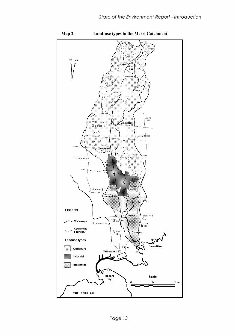
The change in human use of the Merri Catchment since European colonisation is the mostfundamental cause of degradation of the natural environment. Land clearance foragriculture and industrial and urban development (shown on Map 2) has dramaticallyaltered the physical environment, and contributed to the pollution and degradation of thewaterways of the Merri Creek catchment. While it is relatively easy to identify thefactors that are contributing to the decline of the aquatic ecosystem, determining thesources of pollution is a difficult task.
From its headwaters in the foothills of the Great Dividing Range near Wallan, the MerriCreek and its tributaries pass through three main types of land use; agricultural, industrialand urban, before joining the Yarra River in Clifton Hill. The waterways are affected, tovarying extents, by the human activities taking place in these different areas, each ofwhich play a part in determining the state of the creek and the level of pollution of theaquatic ecosystem. It is the cumulative effect of many - individually small - deleteriousactions within the catchment that has radically altered the natural state of the Merri.
In the following sections, the contribution to aquatic pollution from these three main landuse areas will be discussed, at first in general terms and then more specifically as theyrelate to the Merri Catchment.
2.2.2 Agriculture
Agriculture in Victoria remains as the major cause of the decline in quality of the State'saquatic environment (OCE, 1988), and since a large portion of the Merri Creek passesthrough areas of rural land use (around 310 km2) it is clearly of some significance to thewater quality of the Merri Creek.
The major type of agriculture within the Merri Catchment is grazing. Grazing has causeda major change to Victoria’s natural environment as a result of the clearing of nativevegetation and its replacement by 'improved pastures' of high yielding introduced speciesreliant on the application of herbicides and pesticides.
Water runoff from agricultural land washes these chemicals into streams and rivers,where they have a significant impact. Other material such as nutrients from fertilisers, andsoils from eroded land are also washed into the waterways. Water quality may also bedegraded by stock trampling the riparian vegetation and stirring up the stream sediments.Stock faeces may increase the level of potentially harmful bacteria in the stream alongwith increasing the nutrient levels.
While initiatives such as LandCare are generally improving land use practises in manyrural areas elsewhere in the State, there is currently no such group within the MerriCatchment.
State of the Environment Report - Introduction
Page 13
Map 2 Land-use types in the Merri Catchment

Waterways of the Merri Catchment
Page 14
2.2.3 Industrialisation
Industrial activity has historically developed beside water bodies which provided a sourceof water and a sink for the disposal of industrial waste. In the early days of the settlementof Melbourne, much of the pollution of the Yarra River and its tributaries (including theMerri Creek) was a result of such industrial activity and by the late 19th centuryMelbourne's waterways were severely polluted. In 1881, the Health Committee of theCity Council noted that the Merri Creek was being polluted by an abattoir, from which 'anextensive accumulation of blood, offal and manure' was being discarded such that itwould be washed into the creek by the next rains (OCE, 1988).
Today, many industrial areas still exist along the Merri Creek and a large section(approximately 20 km2 or 5% of the total catchment) of the northern suburbs alongsidethe middle segments of the creek is zoned for industrial use. Through the development ofthe sewerage system, better waste disposal techniques and more stringent laws, the waterquality of Melbourne's urban waterways has gradually improved over the past century.However, industrial development is still an important source of water pollution and iscontinuing to cause a deterioration in the health of aquatic ecosystems. While abattoirsmay no longer be polluting the banks of the Merri Creek, the expansion of modernindustry and the more insidious nature of pollution may make further clean-up a moredifficult task.
According to an EPA report, approximately 83% of industrial waste in the Yarracatchment is now discharged to sewer, however another 13.5% (mostly of cooling water)is discharged to drains which flow directly into our river systems (Robins, 1994a). A1982 study of urban stormwater runoff in Melbourne (Weeks, 1982) showed thatpollutants from light industrial areas were significantly higher than those from residentialareas for a number of parameters such as metals and nutrients.
The major types of industry in the Merri Catchment are:
• Motor industry/Transport (eg. Ford, South Pacific Tyres, small scale automotiveindustry, Safeway distributions centre)
• Metal processing (eg. Alcan, Tubemakers Australia)• Quarrying (eg. various Boral quarries)• Construction (eg. Boral bricks, Rocla Pipes)• Waste Disposal (eg. Epping Trade Waste Disposal, City of Whittlesea Tip)• Food Processing (eg. Nestles, Rowntree Hoadley)• Textile, Clothing and Footwear (eg. Australian Consolidated Hosiery)• Petro-chemical (eg. Mobil Oil Australia, Kodak Australasia P/L)

State of the Environment Report - Introduction
Page 15
Box 2 Impacts of Industrial Activity on Waterways
Turbidity: Certain types of industrial effluent contain high levels ofsuspended solids, which increase stream turbidity.
Thermal pollution: Discharge of heated wastewater increases the temperatureof streams. Increased temperature decreases the wateroxygen content, and provides suitable conditions for algalblooms.
Nutrients: Food processing and agricultural industries produce nutrientrich effluent.
pH: Industrial effluent can alter the acidity or alkalinity of streams.
Heavy metals: Metal trades and petro-chemical industries produce wastesthat contain heavy metals such as arsenic, cadmium,chromium, copper, lead, mercury and zinc. Sewagetreatment works are often not able to treat such wastes andthey are released to the aquatic environment where they aretoxic to aquatic life and accumulate with time in the streamsediments.
While it is now an EPA requirement that most industrial waste be treated beforebeing discharged to the sewage system, some industrial waste still reaches theaquatic environment from a number of sources, both from point source anddiffuse (non-point) sources. Such sources include:
Point sources:• Legal direct discharges to water bodies• Discharges of effluent containing industrial wastes• Accidental discharges• Illegal dumping
Non point sources:• Air pollution• Overland runoff• Stormwater
Waterways of the Merri Catchment
Page 16
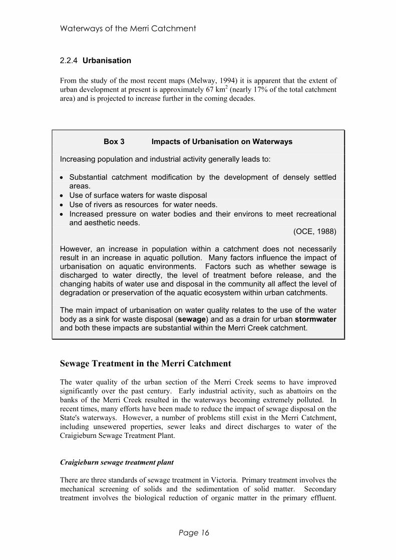
2.2.4 Urbanisation
From the study of the most recent maps (Melway, 1994) it is apparent that the extent ofurban development at present is approximately 67 km2 (nearly 17% of the total catchmentarea) and is projected to increase further in the coming decades.
Box 3 Impacts of Urbanisation on Waterways
Increasing population and industrial activity generally leads to:
• Substantial catchment modification by the development of densely settledareas.
• Use of surface waters for waste disposal• Use of rivers as resources for water needs.• Increased pressure on water bodies and their environs to meet recreational
and aesthetic needs.(OCE, 1988)
However, an increase in population within a catchment does not necessarilyresult in an increase in aquatic pollution. Many factors influence the impact ofurbanisation on aquatic environments. Factors such as whether sewage isdischarged to water directly, the level of treatment before release, and thechanging habits of water use and disposal in the community all affect the level ofdegradation or preservation of the aquatic ecosystem within urban catchments.
The main impact of urbanisation on water quality relates to the use of the waterbody as a sink for waste disposal (sewage) and as a drain for urban stormwaterand both these impacts are substantial within the Merri Creek catchment.
Sewage Treatment in the Merri Catchment
The water quality of the urban section of the Merri Creek seems to have improvedsignificantly over the past century. Early industrial activity, such as abattoirs on thebanks of the Merri Creek resulted in the waterways becoming extremely polluted. Inrecent times, many efforts have been made to reduce the impact of sewage disposal on theState's waterways. However, a number of problems still exist in the Merri Catchment,including unsewered properties, sewer leaks and direct discharges to water of theCraigieburn Sewage Treatment Plant.
Craigieburn sewage treatment plant
There are three standards of sewage treatment in Victoria. Primary treatment involves themechanical screening of solids and the sedimentation of solid matter. Secondarytreatment involves the biological reduction of organic matter in the primary effluent.

State of the Environment Report - Introduction
Page 17
Tertiary treatment involves the reduction of nutrients (carbon, nitrogen and phosphorus)in the secondary effluent.
In Victoria, the State Environment Protection Policy for the Waters of Victoria requiressewage discharges to water to receive secondary treatment before being released to theaquatic environment, and establishes that wherever possible sewage should be dischargedto land.
The Craigieburn Sewage Treatment Plant (Craigieburn STP) was established in 1979 totreat and dispose of the sewage from the newly urbanised area of Craigieburn. Untilrecently, it undertook secondary sewage treatment before disposing of secondary effluentinto the Merri Creek. This has recently been upgraded to partial tertiary treatment, withthe removal of phosphorus from the effluent. While secondary treatment of effluentreduces levels of the biological oxygen demand (BOD), and does not thereforedeoxygenate the creek to the same extent that raw sewage would, it still has high levels ofnutrients which have substantial impacts on water quality. The extent to whichphosphorus removal has improved the water quality is not yet evident. A recent study ofthe Merri Creek indicates that the Craigieburn STP is still the significant source ofnutrients in the catchment (Merrick, pers. comm.).
There was an amendment to the EPA waste discharge licence for the Craigieburn STP on30 September 1993. The standards of the discharges to water for this amended licenceare listed in Table 1 below:
Table 1 EPA Water Discharge Standard for Craigieburn STP as fromSeptember 1993
Indicator Unit Discharge StandardsMedian 90th percentile Maximum
BiochemicalOxygenDemand
mg/L 10 20 -
SuspendedSolids
mg/L 15 30 -
E. coli orgs/100mL 200 1,000 -Total ResidualChlorine
mg/L - - 1.0
Ammonianitrogen
mg/L 5 - 15
TotalPhosphorus *
mg/L 2.0 - -
Flow kL/day 3,000 - 11,000* Higher phosphorus standards came into effect on 1 December 1993
Historically, the main area of non-compliance at Craigieburn STP has been phosphorusand E. coli. All Yarra Valley Water licences have been recently amended for a uniformcondition of 10-10-10-1 standard (10 mg/L total suspended solid, biological oxygendemand & total nitrogen and 1 mg/L phosphorus). This is not apparent from the mostrecent licence for the Craigieburn STP.
Waterways of the Merri Catchment
Page 18
It is possible that a mixing zone will apply to the Merri Creek downstream of thetreatment plant, the length of which is not yet defined. Yarra Valley Water will need toapply to the EPA for approval of this mixing zone under the provisions of the updatedSEPP for the Yarra catchment. (Note: A mixing zone is an area in the receiving watersbelow an effluent discharge where assimilation of effluent takes place and certainenvironmental values/beneficial uses are not protected. Where possible, the use of thesezones should be limited, ANZECC, 1992).
While the Craigieburn STP was originally only a short term measure until the completionof the North Western Trunk Sewer, it now appears that it will remain in operationindefinitely and will be expanded to twice its current capacity to deal with the increase inurban development in the region. Yarra Valley Water has recently (June 1996) completeda Waste Management Plan for Craigieburn. This includes an action plan to reduceimpacts and minimise waste, and a Wastewater Re-use Feasability Study.
Unsewered properties
As the growth of urban areas has previously preceded the necessary infrastructure, manyproperties remained unsewered for some time, and such properties still exist in certainareas. For such properties, individual sewage treatment facilities are required, and this isusually a septic tank. While a small number of septic tanks are unlikely to have muchimpact on water quality, septic tank effluent is recognised as a source of water pollution,especially when many tanks are concentrated in one area.
According to Yarra Valley Water, there are 60 000 residential properties connected tosewer in the Merri Creek catchment, with 16 800 additional residential propertiesproposed by the year 2011. Yarra Valley Water has a Sewer Backlog Program whichaims to service 230 currently unsewered industrial lots over the next 10-15 years.
Sewer spills
Emergency Relief Systems, i.e. systems in place that allow sewage to be discharged tostormwater drains when the pressures in the sewer demands release, have been improvedrecently. For the Merlynston Sewer, there has been a reduction in volume from 56megalitres in 1992/93 to 20 megalitres in 1993/94 and for Edgars Creek, from 31 to 28for the same periods. The improvements reflect improvements to the hydraulic capacityand more favourable weather conditions (Melbourne Parks & Waterways, 1995).
Stormwater treatment in the Merri Catchment
The importance of urban stormwater on the health of urban streams historically has notbeen adequately considered; partly because of the difficultly in dealing with suchwidespread pollution sources. Urbanisation increases the volume of stormwater runoff,while the quality of this runoff decreases considerably.
Stormwater is a “diffuse source” of pollution, that includes contaminants such as highnutrient-containing detergents from street car-washing, bacteria from animal faeces,vegetation, litter and heavy metals, oil and grease from roads. The increasing volume of
State of the Environment Report - Introduction
Page 19
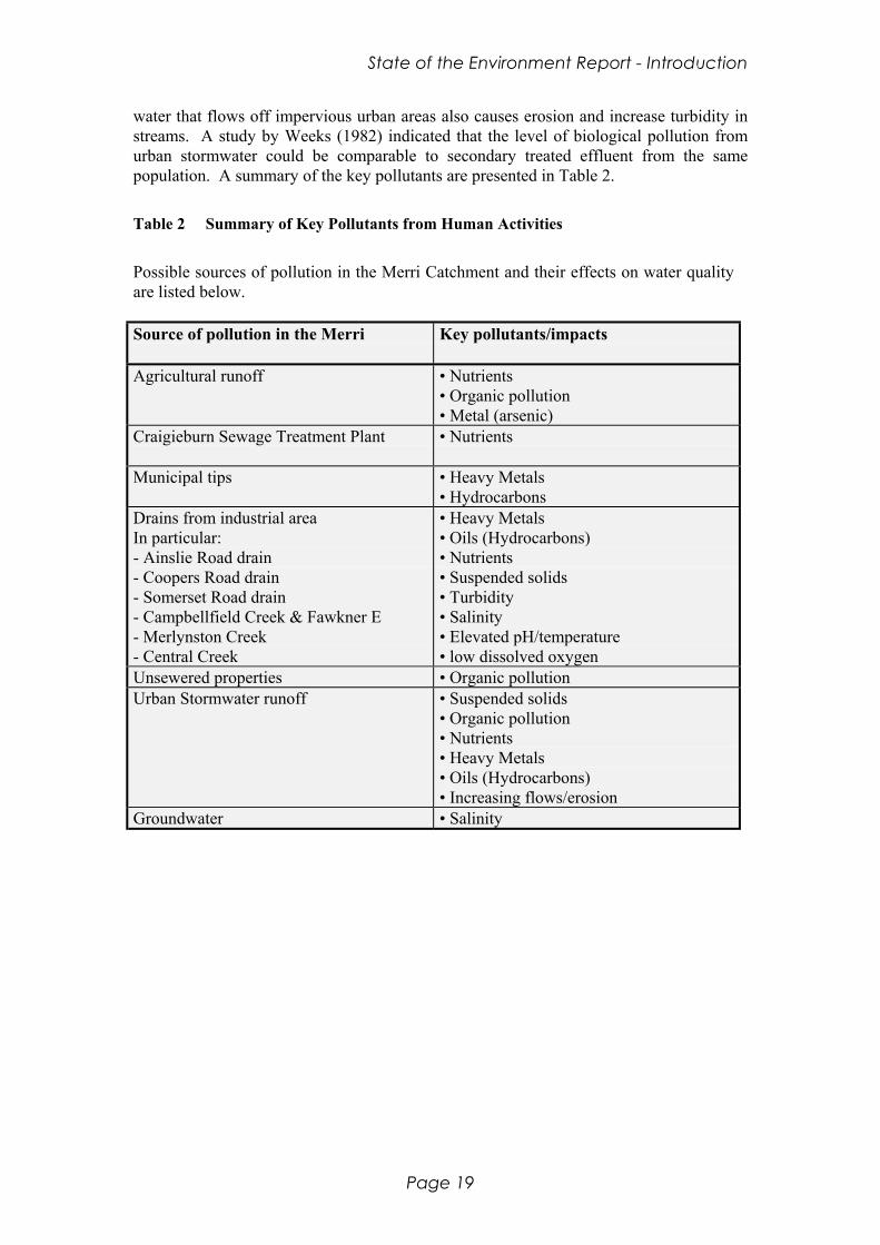
water that flows off impervious urban areas also causes erosion and increase turbidity instreams. A study by Weeks (1982) indicated that the level of biological pollution fromurban stormwater could be comparable to secondary treated effluent from the samepopulation. A summary of the key pollutants are presented in Table 2.
Table 2 Summary of Key Pollutants from Human Activities
Possible sources of pollution in the Merri Catchment and their effects on water qualityare listed below.
Source of pollution in the Merri Key pollutants/impacts
Agricultural runoff • Nutrients• Organic pollution• Metal (arsenic)
Craigieburn Sewage Treatment Plant • Nutrients
Municipal tips • Heavy Metals• Hydrocarbons
Drains from industrial areaIn particular:- Ainslie Road drain- Coopers Road drain- Somerset Road drain- Campbellfield Creek & Fawkner E- Merlynston Creek- Central Creek
• Heavy Metals• Oils (Hydrocarbons)• Nutrients• Suspended solids• Turbidity• Salinity• Elevated pH/temperature• low dissolved oxygen
Unsewered properties • Organic pollutionUrban Stormwater runoff • Suspended solids
• Organic pollution• Nutrients• Heavy Metals• Oils (Hydrocarbons)• Increasing flows/erosion
Groundwater • Salinity

Waterways of the Merri Catchment
Page 20
2.3 Current Community Attitudes and Uses
Community attitudes towards the Merri Creek and its surrounding parklands have beensurveyed in the past few years during the compilation of the Concept Plan (seeCommunity Consultation Report by Diversity Coalition Inc. & Context Pty Ltd, 1993;Customer research: Survey of Local Residents Report by Jan Bruce & Assoc. Pty Ltd,1993). This section summarises the parts of these reports that relate to the aquaticenvironment of the Merri Creek. Box 4 shows the responses to the questions.
The Merri Creek and its surrounding parkland currently provides an opportunity forwalking, bike-riding and other activities that use the open space and natural environment.Considering the information in the two community consultation reports of the MerriCreek Concept Plan, the features of the Merri Creek that are most appreciated by the localcommunity are natural features of the environment, such as the trees, the wildlife and thewater. It is not too surprising that the main areas requiring improvement expressed by thecommunity are those that will enhance the natural environment of the Merri Creek. Inparticular, factors which are detrimental to the natural features of the creek, such as litter,pollution and poor water quality are areas of major concern. Likewise, actions thatimprove the current state of the natural environment, such as more native vegetation andwildlife are also high priorities.
Several activities which also require the enhancement of the creek, such as fishing andswimming were not major priorities set by the community. While many people maysupport the vast improvement in water quality needed to enable safe swimming andfishing for edible fish in the waterways of the Merri Catchment, they do not appear tosupport the improvement of the water quality for these activities, but perhaps for thegeneral improvement of the natural environment that it would provide.
The small percentage (<1%) of the community that supported the restoration of the MerriCreek corridor was surprising. The significance of this response is unclear, since it is notexplained what is meant by the term 'restoration' in this sense. Given the support for theimprovement of many of the natural features of the Merri Creek, such as nativevegetation, better water quality and more wildlife, it would appear that some degree ofrestoration is a high priority for the community. If 'restoration' implies the absolute returnof the creek to its pre-European state, without walking and bike tracks and especiallywithout non-aboriginal people, then this response is not so surprising.
The Merri Creek Management Committee has run, and continues to run, a number ofcommunity education programs aimed at increasing the awareness of environmentalissues of the community in general and shop traders in particular (Lawrie, pers. comm.).Particular projects include; Drains to the Merri, in which a Platypus is painted on draininlets in order to draw attention to stormwater movements and their effects. Anotherproject has been with Sydney Road Traders to try to limit the litter emanating from theirstores.

State of the Environment Report - Introduction
Page 21
Box 4 Community Consultation Report
From October to December 1992, the local community of the Merri Creek weresurveyed to determine their attitudes towards the existing Merri Creek parklands,how they currently use the parklands and their preferences for futuredevelopment. The report concentrated specifically on the attitudes of the young(both primary and secondary school students), those from non-English speakingbackgrounds and community and special interest groups.
The main community uses of the creek and surrounding parkland was assessedby asking:
1. How do you spend your time at the Merri Creek?
The main (>10%) responses and the percentage of the total response were :
Walking ............................... 38%Bike riding ........................... 17%Having fun/informal games. 16%Relaxing.............................. 10%
Other responses directly relevant to the waterways were:
Exploring/observing nature.9%Fishing ................................3%Water: playing/swimming....2 %Boating/canoeing................1%
2. What features of the Merri Creek do you enjoy?
The main (>10%) responses and the percentage of the total response were:
Trees...................................22 %Nature/animal/birds ............19%Water ..................................17%
Other responses directly relevant to the waterways were:
Running water.....................2%Environment........................2%Swimming ...........................<1% continued next
page...
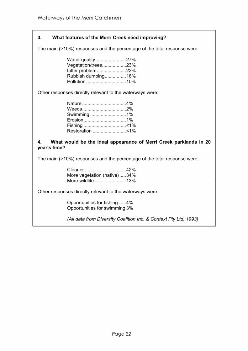
Waterways of the Merri Catchment
Page 22
3. What features of the Merri Creek need improving?
The main (>10%) responses and the percentage of the total response were:
Water quality.......................27%Vegetation/trees..................23%Litter problem......................22%Rubbish dumping................16%Pollution ..............................10%
Other responses directly relevant to the waterways were:
Nature .................................4%Weeds.................................2%Swimming ...........................1%Erosion................................1%Fishing ................................<1%Restoration .........................<1%
4. What would be the ideal appearance of Merri Creek parklands in 20year's time?
The main (>10%) responses and the percentage of the total response were:
Cleaner ...............................42%More vegetation (native).....34%More wildlife........................13%
Other responses directly relevant to the waterways were:
Opportunities for fishing......4%Opportunities for swimming 3%
(All data from Diversity Coalition Inc. & Context Pty Ltd, 1993)
State of the Environment Report - Introduction
Page 23
2.4 Agencies and Institutions
2.4.1 The Players
The agency with most political interest in activities concerning the waterways of theMerri Catchment is the Merri Creek Management Committee; there is, however, acomplex web of institutions and structures that appear on the political map all of whichhave some degree of influence over activities within the Merri Catchment. This sectionintroduces these agencies; the legislation, strategies and other instruments through whichthey act are discussed in Statutory Objectives.
Community sphere
• Friends of Merri Creek• Friends of Merri Merri Park• The residential community• The business community
Local Government sphere
• City of Moreland• City of Darebin• City of Hume• City of Whittlesea• City of Yarra• Shire of Mitchell
State Government sphere
• Melbourne Water Corporation (MWC)• Parks Victoria (PV) (ex Melbourne Parks and Waterways MPW)• Yarra Valley Water (YVW)• Environmental Protection Authority (EPA)• Department of Natural Resource & Environment (DNRE)• StreamWatch• Port Phillip Catchment and Land Protection Board• YarraCare
Federal Government sphere
• Department of the Environment• Commonwealth Environment Protection Authority (CEPA)• Environment Australia (ex Australian Nature Conservation Agency ANCA)• Councilnet• Environment and Resource Information Network (ERIN)• Save the Bush• LandCare Australia• Greening Australia (Victoria) Ltd
Waterways of the Merri Catchment
Page 24
Community Sphere
The Merri Creek Management Committee is controlled by a board of 18 directors whoconsist of two places for each of the five member councils, two representatives fromMelbourne Water Corporation, and six community representatives from the Friends ofMerri Creek.
The Friends of Merri Creek were formed in 1988 and have a broad interest in manyaspects of the Merri Creek environment. The Friends have been and still are the mostinfluential community group in the catchment. Who are they and who do they represent?To be a “friend of Merri Creek” one does not need to live in the catchment but themajority of members do and use the creek parklands regularly. The people who are activein this community are, to broadly categorise them, from a more affluent and bettereducated background than the majority of the residents in the catchment. A highproportion of the members live in the inner portion of the urbanised catchment. This is inaccordance with the respondents to the recent survey of people interested in the MerriCreek (Jan Bruce & Assoc., 1993). The demographics of these people interested in creekmatters is different to the average for Melbourne. The survey revealed that the peoplemost concerned for the welfare of the creek were well educated (53% of respondents hadtertiary education). There is also an above average representation of cultures other thanAustralian.
There are even more “local” community organisations with quite specific interests and theFriends of Merri Merri Park is one such group. These local groups are encouraged bythe larger Friends of Merri Creek.
It is worth noting that there are no organised rural community groups in the catchmentsuch as a LandCare or StreamWatch group. This may mean that rural problems are beingignored in favour of more “obvious” urban ones; “the squeaky wheel gets the oil”. Thismay mean that important rural problems go on unaddressed but also affect thedownstream portion of the catchment to the detriment of the community living there.
Discussions with a local resident in the Craigieburn area revealed that a LandCare groupwas tried in the area but it received no support from the DNRE. An extension officer forthe Melbourne region was not allocated to this area and the opportunity was missed. Theretired Victorian President of the National Farmers Federation, Roger Mason, lives in thearea and has tried to get it “up and running” but received no departmental support.
The Community is more likely to engage in these sorts of activities if they perceive thatthey (their lifestyles) are under threat. For example, they are more likely to do somethingabout the problem of needle grass if they could be made aware that their cattle will not eatit and therefore their pasture will eventually become unproductive. If landownerscurrently want to become involved they would probably use the Whittlesea AgriculturalSociety or the Plenty Valley Conservation Society.
Local Government sphere
Six councils run municipal affairs in the Merri Catchment (Map 3) and each gives theMerri Creek varying amounts of attention. Each council has aconservation/environmental officer who contributes in some way to the Merri Creek. Atpresent there is a deal of uncertainty within each council as to tenure, and a high turnover
State of the Environment Report - Introduction
Page 25
of staff has led to the loss of knowledge and informal communication networks. This losshas the effect of making each municipality a little more insular. Another factor is theCompulsory Competitive Tendering process that each council is forced to adopt. Thisprocess will probably have some long-term benefits for the creek. In the short-term,however, it means that services previously carried out by one part of the organisation nowmay be out-sourced to a number of different private firms causing a less unified approachto waterway management. The Merri Creek Management Committee was, beforeamalgamation, working closely with all these councils except the Shire of Kilmore. TheMCMC now works with all the new councils except the Shire of Mitchell and hasrepresentation of each of these councils (two places per council) on the MCMC board.
State Government Sphere
The Department of Natural Resources and the Environment is the body to which anumber of agencies (listed below) report. The Department resigned its place on theMCMC board in 1995. The department also has a number of branches which are able toprovide technical advice and support:
• Office of Water Reform; develops water management policy. It has funded wetlandinvestigations and has some expertise in this area.
• Flora and Fauna Guarantee; officers are able to provide advice and management plansfor landowners who have endangered species on their properties.
• Flora and Fauna Branch; undertakes wildlife research and management options.• Land for Wildlife Scheme; joint operation with the Bird Observers Club and provides
management advice for landholders (in the form of Extension Officers).

Waterways of the Merri Catchment
Page 26
Map 3 Merri Creek Catchment and Municipal Boundaries

State of the Environment Report - Introduction
Page 27
Melbourne Water Corporation (MWC) is responsible for major works along the creeksmainly related to flood mitigation as is the maintenance of the main stormwater drains.They also collect water quality data (on behalf of the EPA) and streamflow data. Theycurrently have one representative on the Merri Creek Management Committee board.Recently Melbourne Water has divested itself of its water supply arm, splitting thisresponsibility into three corporatised bodies for future privatisation; Yarra Valley Waterand City West Water each control parts of the Merri Catchment. There appears to beopportunity for further privatisation of services. They come under the umbrella of theDepartment of Natural Resources and the Environment. Melbourne Water sometimesfunds part of the Merri Creek Management Committee’s manager’s salary.
Melbourne Parks & Waterways (MPW) is responsible for managing the majormetropolitan parks. In the Merri Creek they provide project funding for revegetationworks. The Merri Creek receives part of the $100 000 allocated to councils for restoringbike paths, etc. Like MWC, MPW comes under the umbrella of the Department ofNatural Resources and the Environment.
Environment Protection Authority (Victoria) is the main body responsible for ensuringenvironmental protection in Victoria. The organisation creates State EnvironmentProtection Policies, which set objectives for environmental standards for which beneficialuses of the environment are protected.
YarraCare is a community-based program aimed at identifying and managingcatchment-wide land and waterway issues. The program involves all the key governmentagencies listed above and many community representatives.
Port Phillip Bay Catchment and Land Protection Board co-ordinates catchmentmanagement in the Melbourne region.
National sphere
The Commonwealth Department of the Environment (DEST) is the FederalGovernment department responsible for many of the environmental conservation groupsthat operate across Australia. It is also the department to which the CommonwealthEnvironment Protection Authority and the Australian Nature Conservation Agencyreport.
Commonwealth Environment Protection Authority (CEPA) takes a leading role in co-ordinating the various state EPAs and administers specific Commonwealth Acts includingthe Environment Protection (Impact of Proposals) Act (1974).
Australian Nature Conservation Agency (ANCA) is the Commonwealth bodyresponsible for administering programs such as Save the Bush and One Billion Treesunder the umbrella of the National Landcare Program.

Waterways of the Merri Catchment
Page 28
Networks and programs developed by DEST and ANCA
Councilnet is an electronic network designed to provide environmental information andfacilitate communication for local government
ERIN (Environment and Resource Information Network) is a network for theprovision of support for the Save the Bush and One Billion Trees programs. Part of this isa national environment biological database.
Save the Bush is a program developed to retain the remnant native vegetation throughoutAustralia. ANCA partially funds the program and over half this money goes directly tothe community, local government and educational institutions. Projects such as brochurepublication and sign construction and surveys of flora and fauna within local ecosystemshave been funded in the past.
LandCare is a network of community organisations committed to restoring Australia’svegetation resources. The groups try to co-ordinate work on a catchment-wide basis.Traditionally rural in outlook, they have been concerned with issues such as salinity, soilstructure decline, soil acidity, weed invasion and pest species and stream erosion. SomeLandCare groups are involved in monitoring activities such as Saltwatch.
Waterwatch is an education and awareness program co-ordinated by ANCA. Thisinitiative fosters community-based water quality monitoring programs.
Other networks and organisations
Nexus is an electronic network that links educational institutions across Australia. Itprovides access for students to a range of current information about the environment.
Greening Australia (Victoria) is a non-profit community organisation committed toprotecting and restoring local native vegetation. It receives Federal Government fundingthrough the One Billion Trees program. In Victoria it receives State Government grantsand private sponsorship. It allocates money, through its projects, to community-basedschemes.

State of the Environment Report - Introduction
Page 29
2.5 Legislation, Strategies and Policies
A number of different pieces of legislation and strategic direction have an influence incontrolling actions within the Merri Catchment. These exist at all levels, frominternational conventions to State Government policy. This section outlines the maininstruments that relate to the waterways of the Merri Catchment.
The most important piece of legislation controlling water quality in the waterways of theMerri Creek catchment is a state act, the Environment Protection Act (1970). Theimplications of this act on the Merri Catchment are outlined in some detail before turningto other pieces of relevant legislation.
2.5.1 The Environment Protection Act 1970 (Vic.)
The Environment Protection Act (1970) established the Environment ProtectionAuthority and outlines its responsibilities and powers for the protection of theenvironment. Through the development of State environmental policy, it aims to protectthe main beneficial uses of the environment by managing waste discharges, preventingpollution, and protecting and improving environmental quality.
Regarding water quality, the Environment Protection Policy has a number of strategiesfor environmental protection, in particular State Environment Protection Policies (seeBox 5 for background) and licences to discharge waste to water.
Box 5 State environment protection policy
The State environment protection policy (SEPP) establishes the "basis for maintainingenvironmental quality sufficient to protect existing and anticipated beneficial uses" for aparticular area, and specifies:
• Boundaries of the area affected• Identification of the beneficial uses to be protected• Selection of environmental indicators to be employed to measure and define the
environmental quality• A statement of environmental quality objectives• The program by which the stated environmental quality objectives are attained and
maintained
The SEPP is the benchmark on which all activities affecting the aquatic environment arecompared and all EPA licences and works approvals must be consistent with it.

Waterways of the Merri Catchment
Page 30
State environment protection policies (SEPPs)
The three policies that specifically concern the Merri Catchment are outlined in Box 6.
Box 6 SEPPs affecting the Merri Catchment
SEPP (Waters of the Yarra River and Tributaries)
This is the main policy controlling the water quality of the Merri Creek and its tributaries. TheYarra SEPP was developed for the Yarra catchment in 1984 and sets the benchmark towhich all activities affecting the aquatic environment. All EPA licences and works approvalsmust be consistent with this policy. This policy is currently being updated and will become aSchedule to the statewide policy (Waters of Victoria). A draft for public comment wasreleased in December 1995 and should be finalised by 1997.
The beneficial uses for the creek are different for the upstream (rural) segment anddownstream (urban) segment, with the upstream segment given a higher value.
The environmental indicators for the SEPP are mainly physico-chemical parameters,including things such as: dissolved oxygen, E. coli, pH, temperature and toxicants. These,along with the identified beneficial uses for the Merri Creek, are outlined in Appendix 1.
SEPP (Waters of Victoria)
Most of the provisions for the waterways of the Merri Catchment are covered in more detail inthe SEPP that was developed for the Yarra catchment in 1984. However, the SEPP for theYarra River is currently being updated, and will be included as a schedule to the SEPP(Waters of Victoria).
The new schedule of the SEPP (Waters of Victoria) has not yet been released for publiccomment, it is expected to contain a number of revisions (R. Costello, pers. comm.), whichmay include:
The beneficial uses have been updated, with more of an emphasis on the protection ofaquatic ecosystems. Primary contact is set as a beneficial use by 2003.
The water quality objectives to protect the beneficial uses will be those specified in theAustralian Water Quality Guidelines for Fresh and Marine Waters and will generally be morestringent than the 1984 Yarra SEPP.
A number of new Indicators and Objectives have been added, of particular interest is aquantitative measure for nutrients; coprostanol as an indicator of human effluent; and thedevelopment of quantitative ecological indicators.
SEPP (Groundwaters of Victoria)
A draft SEPP (Groundwaters of Victoria) was released for public comment by the EPA (Vic.)in October 1994. The objective of this SEPP is to reserve groundwater resources that arefree from contamination for future use and to protect the ecological values of surface waters.The water quality objectives of this SEPP are based on the National Groundwater QualityGuidelines and the SEPP (Waters of Victoria).

State of the Environment Report - Introduction
Page 31
Monitoring and Research
The EPA has carried out various monitoring programs and research on the Merri Creekand other waterways throughout the State. The objective of the EPA's monitoringnetwork is to describe the environmental condition of Victoria’s waters, detect trends inwater quality and to assess whether the water quality objectives are being met (EPA,1993).
EPA Licences to Discharge Waste to Water
In the best interest of the aquatic ecosystem, no waste should be discharged to streams.However, in the absence of adequate sewage disposal infrastructure, the EPA licensesvarious organisations to discharge waste to water.
Licence conditions are determined by the EPA based on the type of industrial or sewageeffluent and the impacts of these pollutants on the aquatic environment. It assumes thatsufficient knowledge exists about the streamflow and basic physical, chemical andbiological conditions of the stream in addition to the immediate and cumulative effects ofsuch waste discharges on the aquatic environment. As will be illustrated in the WaterQuality section, monitoring of the environmental condition of the Merri Creek is arelatively recent project and currently insufficient data exists to infer trends in waterquality.
Such an approach also assumes that streams have an 'assimilative capacity' and are able totolerate the limited input of waste materials without suffering ecological deterioration(OCE, 1988). In Victoria, where the environmental conditions are relatively unstable dueto large variations in climatic conditions it is not possible to determine a state ofequilibrium of a stream based on studies over periods of a few years.
There are a number of different types of licence as described in Box 7. In the MerriCreek catchment there are a number of licences to discharge waste to water. One of theselicences, the Craigieburn Sewage Treatment Plant Licence has been discussed inUrbanisation. The other licences are listed in Table 3 and Table 4. These licences arescheduled (see Box 7 for explanation) and therefore of high local significance (Robins,1994a)
Extractive industries are licensed to discharge contaminated stormwater; containingsediments and salts, and some trace contaminants such as nutrients, petroleum products,oils and heavy metals. Clay quarries are of particular concern as clay particles are easilysuspended leading to increased turbidity, and the quarries in the Merri Catchment mayalso contribute high salt levels. (Robins, 1994a).
Discharges of sewage and sullage contain oxygen demanding substances and nutrients,and may also contain bacteria, viruses, cysts and worms (Robins, 1994a).
In the unsewered area of Campbellfield, Licence MW 1621 to the Arrowcrest Groupallows the discharge of waste water of elevated temperature and containing tracecontaminants of heavy metals (zinc, iron and chromium). The premises are allowed todischarge a maximum of 140 kL/day.
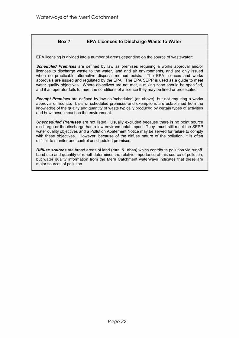
Waterways of the Merri Catchment
Page 32
Box 7 EPA Licences to Discharge Waste to Water
EPA licensing is divided into a number of areas depending on the source of wastewater:
Scheduled Premises are defined by law as premises requiring a works approval and/orlicences to discharge waste to the water, land and air environments, and are only issuedwhen no practicable alternative disposal method exists. The EPA licences and worksapprovals are issued and regulated by the EPA. The EPA SEPP is used as a guide to meetwater quality objectives. Where objectives are not met, a mixing zone should be specified,and if an operator fails to meet the conditions of a licence they may be fined or prosecuted.
Exempt Premises are defined by law as 'scheduled' (as above), but not requiring a worksapproval or licence. Lists of scheduled premises and exemptions are established from theknowledge of the quality and quantity of waste typically produced by certain types of activitiesand how these impact on the environment.
Unscheduled Premises are not listed. Usually excluded because there is no point sourcedischarge or the discharge has a low environmental impact. They must still meet the SEPPwater quality objectives and a Pollution Abatement Notice may be served for failure to complywith these objectives. However, because of the diffuse nature of the pollution, it is oftendifficult to monitor and control unscheduled premises.
Diffuse sources are broad areas of land (rural & urban) which contribute pollution via runoff.Land use and quantity of runoff determines the relative importance of this source of pollution,but water quality information from the Merri Catchment waterways indicates that these aremajor sources of pollution
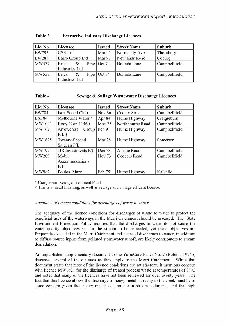
State of the Environment Report - Introduction
Page 33
Table 3 Extractive Industry Discharge Licences
Lic. No. Licensee Issued Street Name SuburbEW795 CSR Ltd Mar 91 Normandy Ave ThornburyEW285 Barro Group Ltd Mar 91 Newlands Road CoburgMW537 Brick & Pipe
Industries LtdOct 74 Bolinda Lane Campbellfield
MW538 Brick & PipeIndustries Ltd
Oct 74 Bolinda Lane Campbellfield
Table 4 Sewage & Sullage Wastewater Discharge Licences
Lic. No. Licensee Issued Street Name SuburbEW704 Istra Social Club Nov 86 Cooper Street CampbellfieldEX184 Melbourne Water * Apr 84 Hume Highway CraigieburnMW1041 Body Corp 11460 May 75 Northbourne Road CampbellfieldMW1621 Arrowcrest Group
P/L †Feb 91 Hume Highway Campbellfield
MW1625 Twenty-SecondSaldean P/L
Mar 78 Hume Highway Somerton
MW199 JJR Investments P/L Dec 73 Ainslie Road CampbellfieldMW209 Mobil
AccommodationsP/L
Nov 73 Coopers Road Campbellfield
MW987 Poulos, Mary Feb 75 Hume Highway Kalkallo
* Craigieburn Sewage Treatment Plant† This is a metal finishing, as well as sewage and sullage effluent licence.
Adequacy of licence conditions for discharges of waste to water
The adequacy of the licence conditions for discharges of waste to water to protect thebeneficial uses of the waterways in the Merri Catchment should be assessed. The StateEnvironment Protection Policy requires that the discharges to water do not cause thewater quality objectives set for the stream to be exceeded, yet these objectives arefrequently exceeded in the Merri Catchment and licensed discharges to water, in additionto diffuse source inputs from polluted stormwater runoff, are likely contributors to streamdegradation.
An unpublished supplementary document to the YarraCare Paper No. 7 (Robins, 1994b)discusses several of these issues as they apply to the Merri Catchment. While thatdocument states that most of the licence conditions are satisfactory, it mentions concernwith licence MW1621 for the discharge of treated process waste at temperatures of 37oCand notes that many of the licences have not been reviewed for over twenty years. Thefact that this licence allows the discharge of heavy metals directly to the creek must be ofsome concern given that heavy metals accumulate in stream sediments, and that high

Waterways of the Merri Catchment
Page 34
levels of metals are believed to be having a large impact on the health of the aquaticmacroinvertebrate community (Mitchell & Clark, 1991).
Compliance with EPA licences to discharge waste to water
Even if the licence conditions set by the EPA are sufficient to protect the aquaticecosystem, this is inadequate if these licence conditions are not being met by the licenceholders. Evidence from Robins (1994b) indicates that this is the case in the MerriCatchment, where inadequate sampling and recording of discharges is taking place andwhere "compliance is low for most of the data set and moderately satisfactory for a selectfew" (Robins, 1994b). Some examples of recorded failures to comply with EPA licenceconditions are the release of heated (37oC) wastewater and the discharge of effluent withE. coli levels similar to those recorded in raw sewage.
EPA is currently completing a review of all small sewage treatment plants in the Yarracatchment. As a result of this review, most licences will be amended to better reflectexisting conditions and expectations, and minimise impact.
EPA Licences to Discharge Waste to Air
Contamination of rainwater from airborne particules is a major source of pollution. TheEPA has incorporated licences to discharge waste to air into the requirements ofstormwater discharge for approximately 30 premises in the Yarra Catchment. However,these discharges only represent a small fraction of the contaminated stormwater comingfrom urban and industrial areas.
2.5.2 Other State legislation
Besides the Environment Protection Act (1970), a number of other State acts apply to thewaters of the Merri Catchment, and are described in Appendix 2. The most importantof these are the acts to do with planning issues (eg. the Planning and Environment Actand Local Government Act) as they have the potential to refuse or permit most of thepractices that result in broad land use changes. Other acts such as the various “protectionacts” are, as their name suggests, supposed to protect land, species and waters fromdegradation.

State of the Environment Report - Introduction
Page 35
2.5.3 Commonwealth strategies, legislation and policies
The Commonwealth strategy of most direct relevance to the future restoration of theMerri Creek waterways is the National Water Quality Management Strategy. There are anumber of other strategies, acts and conventions (some of which are described inAppendix 3) which shape the Federal Government’s policies toward the environment.
National Water Quality Management Strategy
The National Water Quality Management Strategy, as the title suggests, aims to integratewater quality management at a national level. As an integral part of this strategy, theAustralian Water Quality Guidelines for Fresh and Marine Waters has been established toprovide numerical and narrative criteria to assist in the sustainable management of waterresources.
The structure of the Australian Water Quality Guidelines is similar to those of the EPA(Vic) State Environment Protection Policy. It defines the environmental values(beneficial uses) to be protected, establishes water quality objectives that become thegoals for management action, and sets key indicators of water quality to identify andmeasure the change in the environmental values.
The five environmental values considered in the national guidelines for both marine andinland waters (ANZECC, 1992) are:
• ecosystem protection, including protection of waters used for shellfish and fishproduction and by wildlife;
• recreation and aesthetics;• raw water for drinking water supply;• agricultural water;• industrial water.
Of particular interest to this report are the guidelines for the protection of aquaticecosystems and for the protection of human consumers of fish and other aquaticorganisms, which are summarised in Appendix 11.
The national guidelines recognise the use of indicators is based on the assumption that:
• it is possible to specify particular indicators of water quality• there are particular measurable concentrations of these indicators that can be
specified below which either adverse effects will not occur or the risk of sucheffects is low.

Waterways of the Merri Catchment
Page 36
2.6 Current Arrangements
The three tiers of Government in Australia each in their own way has an influence on theenvironment of the Merri Creek Catchment. The Federal Government, whilst having nodirect control of any part, except the Broadmeadows Military Establishment and theReserve Bank of Australia mint at Craigieburn, has indirect interests in many ways. Itprovides funding for JobSkills programs, Greening Australia projects (primarily throughthe One Billion Trees project), etc. It also grants recognition to areas of special interest orvalue such as National Trust sites.
The State Government, by way of its strategic planning, has an enormous impact on thecatchment. It would be reasonable to assert that, the State Government being responsiblefor regional planning of the industrial and urban development of the northern suburbs ofMelbourne, it is the architect of greatest change that has taken place in the catchmentduring European Settlement. Therefore the long-term policies that each successive StateGovernment generally adheres to are critical in shaping the development in thecatchment.
Local Government also has direct influence on the development of the catchment. Untilrecent council amalgamations, the catchment has been controlled by ten municipalitiesincluding Whittlesea, Broadmeadows, Preston, Coburg, Northcote, Brunswick,Collingwood, and Bulla. Since the amalgamations of 1993, this array has been reducedby four to the Cities of Moreland, Darebin, Hume, Yarra and Whittlesea and the Shire ofMitchell. Theoretically this should mean better co-ordination of the various inter-councilprojects. However, to date it seems not to be the case.
Historical Political Landscape
The Merri Creek runs through what many consider to be the Autralian Labor Party’s“heartland of the north”. People in the working class suburbs of Fitzroy, Brunswick,Northcote, Coburg and Preston have been strong supporters of Labor governments overthe years and this may have been taken for granted somewhat. More recentlygovernments have recognised the potential of the “Green Vote” in the electorate.Governments both Labor and non-Labor have traditionally been much more concernedabout employment opportunities than preserving “Green Corridors” and the Merri Creekcorridor is a good example of this. From the beginning of European settlement to thepresent day the Merri Creek and its tributaries have served as drains for the manyindustries that have developed along the banks. The cheap housing associated withindustrialised areas, was affordable by the working class ensuring that the voters of thecorridor were solidly behind the Labor Party.
One of the single most important decisions that has affected the Merri Creek corridor wasin 1969, when the Bolte Liberal Government decided to build a freeway along the MerriCreek valley to link up with the Eastern Freeway at Alexandra Parade. This decisionalong, with the general increase in awareness of environmental issues in the early 1970s,led to the community galvanising in opposition to development along the creek. Theformation of action groups opposing the construction of the freeway naturally followed.The Merri Creek Action Group and the Fitzroy Residents Association were at the
State of the Environment Report - Introduction
Page 37
forefront of these groups, the latter commissioning the Public Interest Research Group(PIRG) study of the Merri Creek in 1975.
One year after publication of the study, co-operation between councils and thecommunity resulted in the formation of the Merri Creek Co-ordinating Committee. Overthe following thirteen years this committee not only successfully opposed theconstruction of the freeway (the F2) and powerlines but also built cycle paths and usedenvironmentally sensitive flood mitigation measures on the Merri Creek (Taylor, 1994).
It is interesting to note that it is only recently (1992) that the proposal for a freeway in thelower part of the Merri Corridor was officially taken off the planning books. However,the plans for the freeway had some unexpected benefits for the creek. In 1974, theproposal blocked moves by the MMBW to “improve” the Merri. Earl (1974) statesthat“...Until such time as the route of the F.2 Freeway is determined and, most likely,until such time as the freeway project is started and the right of way for the future creek iscleared, it is considered that it is not practical to construct major permanent improvementsto the creek...” As the proposal was “on the books” for so long, it may have beeninstrumental in deferring indefinitely such drastic works.
Current Political Landscape
Nevertheless, it is a sobering thought that had the freeway still been proposed now, underthe Kennett Liberal Government, that community action may not have had the samepower to block construction. The communities affected by the proposed extension andwidening of the Tullamarine Freeway are finding this out to their detriment and primarilybecause they do not have the same structures in place (ie. an active, community-basedmanagement committee) and are struggling to have any input into that proposal.However, the current government is fast developing a reputation for minimal consultationwith the community about important environmental decisions and it is debatable as towhat, if any, influence such a management group as the MCMC would have if thegovernment decided to put the freeway down the Merri Corridor instead.
2.7 Conclusions
People have played a large part in shaping the Merri Catchment into the state it is intoday. There is evidence that the indigenous Wurundjeri people lived by the waterwaysand used many of the features in the environment in their lives. However, since Europeancolonisation there has been a dramatic change in the state of the waterways as a result ofhuman activities in the catchment.
Agriculture, industry and residential landuse have had an impact on the waterways, andwill continue to affect them in the future. The main issues, as a direct result of humanactivities, are;
• loss of vegetation and habitat, through land clearance for agriculture• discharge of effluent to the waterways of the catchment from the Craigieburn Sewage
Treatment plant and several EPA licensed industries

Waterways of the Merri Catchment
Page 38
• diffuse source input of pollutants to the waterways via the stormwater drainagesystem.
Many of these problems have grown out of the historical social, political and institutionalsystems in the catchment. Change to the structure of these systems is necessary beforeimprovement to the quality of the waterways can be expected. These changes have beentaking place over many years, as is evident in the community attitudes to the waterways,however more change is needed if the waterways are to be restored. These issues areraised again in the following sections, and the Action Plan provides a means ofaddressing them to restore the waterways of the Merri Catchment.

State of the Environment Report - Introduction
Page 39
Summary: Geomorphology and Flow
This section describes the major ways in the channel form and flow patterns of the MerriCatchment are known to have changed since European settlement.
The main surveys used in preparing this section are presented in Table 5.
Table 5 Overview of surveys examining geomorphology and flow in the MerriCatchment (n.a. means not applicable).
Study Type Date Location Type ofparameter
No. ofsites
MMBW long-term
1891 - 1974 Merri Creek flood levels 2
MMBW period May 1974 Merri Creek flow,morphology
n.a.
PIRG review Dec. 1974-Jan1975
Merri Creek morphology 13
N.M.Craigie overview Feb.-March 1994 all sig. streams morphology n.a.MelbourneWater
long-term
May 1974 - Merri & Edgar flow 6
The major creeks in the catchment, as they exist today, are shown on Map 4.
The original form of the Merri Creek and its tributaries is thought to have been of a “chain-of-ponds” in the upper reaches, with a number of permanent or semi-permanent pondsconnected by an intermittently flowing stream. In the lower reaches the form would probablyhave been a sequence of pools and riffles; deep pools with slow flowing water separated byshallow, rocky fast-flowing stretches.
A number of changes have occurred to the waterways since European settlement:
• Channel form is much altered - primarily as a result of channel straightening foragricultural and flood mitigation purposes. It is estimated that only 37% of the MerriCreek remains in a “natural” state, with 51% having had minor modifications and 12%having had extensive modifications (Craigie, 1994).
• Stream flows are also greatly altered, with those in the upper reaches being reduced bywater harvesting and damming, and those in the lower reaches being vastly increased byan increased amount of stormwater.
• Changes to groundwater flows are even less easy to determine. The importance ofgroundwater is clear, but often overlooked - it contributes about 50% of the flow enteringthe Yarra River. A great deal is extracted via bores - annually 269 ML is extracted via1027 registered bores in the “Basalt Plains” of which the Merri Catchment is about onefifth the land area (Haydon, 1994).

Waterways of the Merri Catchment
Page 40
Stormwater
In urban areas, an increase in impervious surfaces has led to an increase in stormwater, andhence an increase in peak flows during storm events. Both the volume and velocity of waterin the system are increased, and the peak occurs much more quickly after a storm. Theincrease in stormwater has led to the construction of a network of drains leading to the MerriCreek. Many of the original natural tributaries have also been piped, for example the lowerreaches of Merlynston Creek (or Merlynston Drain).
Flooding
In order to protect against flooding, largely caused by the increase in stormwater, a numberof measures have been implemented, such as;
• the construction of 5 retarding basins - 3 on Merlynston Creek, 1 on Campbellfield Creekand 1 on Kalkallo Creek. A proposed basin on the Merri Creek at Campbellfield has yet tobe constructed.
• the construction of levee banks on the Merri Creek at Normanby Ave. and Anderson’s St,Sumner Avenue and Winifred St.
• channel straightening and de-snagging• rock or concrete lining
Urban expansion in the catchment will continue to increase the likelihood of flooding unlessmeasures are taken to reduce the volumes of stormwater produced.
Barriers to Flow
One of the most obvious changes in stream character is the blocking of flow by dams andretarding basins. Other than the retarding basins described above, the main barriers in thecatchment are;
• Two artificial weirs - at Coburg Lake and Edwardes Lake - which have no low-flowoutlets and hence in times of prolonged drought could stop flow downstream of the weir.
• Dams on Strathaird Creek and Mittagong Creek There are also a number of illegal dams in the rural areas of the catchment.
Drainage for Agriculture
In rural areas, a great deal of land has been drained for agriculture, resulting in loss ofwetlands and straightening of the watercourses. The remaining wetlands are at;
• unnamed swamp east of Dunlop factory at Campbellfield• Hernes Swamp• Beveridge Swamp (on east side of Spring Street, Beveridge)
State of the Environment Report - Introduction
Page 41
Water Harvesting.
Water is harvested primarily in rural areas, both legally and illegally for irrigation anddomestic purposes. Melbourne Water estimate that a total of 54.2 ML is harvested annually.Whilst representing only a small fraction (~0.32%) of the total flow entering the Yarra, thelocation of the water extraction, in the ephemeral upper reaches, means that the impact of thisharvesting is much greater than it would be otherwise. During drought periods the effects ofwater harvesting on aquatic ecosystems is likely to be particularly important.
Conclusions
The main changes to the geomorphology and flow in the Merri Catchment are channelmodifications such as straightening, snag removal, piping and rock lining, and floodmitigation measures such as construction of retarding basins and levee banks. Drainage ofwetlands and the construction of dams are also major changes.
Waterways of the Merri Catchment
Page 42

State of the Environment Report - Introduction
Page 43
3. Geomorphology and Flow
3.1 Introduction
The geomorphology and flow of the Merri Creek and its tributaries have a major influence onthe aquatic ecosystem, and in turn are influenced by it. For example, geomorphology andflow are major determinants of habitat, and hence the structure of aquatic communities, andvegetation is a major influence in the processes of erosion and deposition (Petts, 1994).
In this section the “natural” and existing states of the geomorphology of the Merri Catchmentare discussed, as well as three aspects of flow; stormwater, groundwater and overland flow.The information presented in this section is compiled from a number of sources, of which themajor works are listed below.
3.1.1 Previous work
The morphology and flow of the Merri Catchment has not been analysed in detail to date.Most of the work has gone into flood prediction and prevention efforts. The only study toexamine stream form for the whole catchment in any depth is by Craigie (1994). As a result,much of this section is based on that work. The most important studies are:
Melbourne & Metropolitan Board of Works (Snowy Mountains Engineering Corp.,1976) studies of flood events from 1891 to 1974. Significant flood events were recordedprior to 1974 (data given in height at certain gauges).
Melbourne & Metropolitan Board of Works (Earl, 1974) study May 1974. This agencyconducted an investigation into the causes of the disastrous floods of 15, 16 of May 1974.This work describes aspects such as geology, physiography, urban development and floodmitigation options.
Melbourne Water Corporation (various reports) streamflow monitoring study fromMay 1974. This study, instigated as a result of the floods, records flow rates from varioussites on the Merri Creek from Craigieburn to St Georges Road. Telemetry is now thecommon method of measurement but this was not always the case. Most reliable low-flowinformation is from Craigieburn and St Georges Road.
N.M. Craigie & Associates (Craigie, 1994) study of February/March 1994. Craigiebroadly surveyed the character of the beds, banks, channels, valleys and streamworks of allthe major streams in the Merri Catchment as part of the “Inventory of waterways of the YarraCatchment” study of the condition of streams.

Waterways of the Merri Catchment
Page 44
Box 8 Rates of Change in the Merri Catchment
It is easy to think of a stream or river system as being constant with time (ie. being inequilibrium) and in some senses this is true - for instance over the period of a fewminutes or hours or even days, it might appear so. However a more thoroughunderstanding reveals that over longer periods this is not the case. The changes inchannel form are affected mainly by erosion and sedimentation and these aredependent on stream power. Thus erosion takes place in areas and at times whenthe stream power is high and deposition occurs in areas where the stream power isreduced. Thus climate, which itself is not static or predictable, is integral to theprocess.
Erosion is a function of volume of water and flow velocity such that when these aremaximised, so the erosion will be. From this it follows that events such as flowduring floods (stormflow) will be more important in causing erosion than normal orbase flow and the bigger the flood event the greater the erosive capacity.
The basic geomorphic form of any creek is determined by the underlying geology ofthe rocks through which the creek passes. For any catchment the geomorphic formchanges from the headwaters to the outflow and this is basically dependent on thegradient of the slope of the channel. The different forms present in the MerriCatchment are; headwaters; swampy alluvial fans; chain-of-ponds type trunk stream;trunk stream.
The natural processes that are occurring in each of these morphological settings aredifferent and occur at different rates. So that when we come to examine changes tothe system, we must bear in mind these natural rates of change. Having said that,there can be no doubt that the changes brought about by humans since Europeansettlement are significant. However, in the longer term (geological time scales), thechanges to stream morphology are probably not of such consequence (ie. streamswill recover their natural form given time). That is not to say that the changeswrought by human landuse changes do not have adverse impacts on streamecology.
However, the changes since European settlers came to this country are immenseand occur over a very short time frame. One of the most obvious changes in streamcharacter is the blocking of flow by dams and retarding basins. In the MerriCatchment there are quite a few of these (see flood control mechanisms). Changesto the channel include widening, straightening, de-snagging, bank protection by rockwalling or tree planting and streambed lining with rocks or concrete.
Scope of this section
The purpose of this section is to examine the current state of the processes that affect thegeomorphology of streams in the Merri Catchment. This is achieved by examining the dataon the Merri Creek in detail for characteristics such as stream type and flow, floodplainfeatures, channel origin, bed composition and stability, aquatic structure, bank stability andbedworks. Although streamflow is very important in shaping habitat, anything more than a
State of the Environment Report - Introduction
Page 45
broad consideration of its influence is beyond the scope of this study. The tributary creeksreceive less attention than the Merri Creek trunk stream; this study includes only the channelorigin and flow character. Some streams are so severely channellised as to becomestormwater drains. This report gives some details of the main drains. The study also outlinesthe areas of wetland in the Merri Catchment.
3.2 “Natural” states
To understand the extent of the changes that may have occurred since European Settlement, itis important to try to understand what the system was like prior to colonisation. As with allaspects of the creek, this task is extremely difficult.
It has been suggested that parts of the Hopkins River in Western Victoria may be as close asone can get to a model for the condition of the Merri Creek prior to settlement (Rutherford,pers. comm.). The portion of the Hopkins River cited is where the stream has incised a deepgorge through the basalt plain across which it flows. This gorge has served as protectionfrom the pressures of grazing, preventing major degradation of the channel. The morphologyof the river that flows through the gorge is that of a chain-of-ponds type stream in whichpermanent or semi-permanent pools of very slowly moving or stationary water lie in thechannel bed and are connected to each other by an intermittently flowing stream.
It might also be possible to gain an idea of the original flow form by examining data gatheredover recent times to develop a model of changes over this period and extrapolatingbackwards in time. Whilst this is theoretically possible, it has not been attempted to date.This is probably because of lack of necessary data - monitoring of daily flows on the MerriCreek commenced in 1975, at just two locations.
The difficulties illustrated by these two accepted methods means that determining “natural”flows is based on assumptions and personal belief.
3.3 Existing states
As described in Human Environment, the physical landscape has changed markedly in thetwo hundred or so years of European settlement. It is therefore not surprising that theenvironment of the Merri Creek and its tributaries have also changed a great deal.
The major changes include:
• habitat destruction from flow changes, channel erosion and channel improvements• increased flows, volumes, and velocities of runoff particularly during storm events• decreased groundwater recharge
These changes are discussed in the following section.
The Merri Catchment can be divided into broad geomorphological settings, which form auseful basis for describing human-induced changes, eg channelisation. In this section, the
Waterways of the Merri Catchment
Page 46
Merri Creek is described using these broad settings. A brief summary of the form and flow ofeach significant tributary is also presented.
3.3.1 The Merri Creek
The Merri Creek has its origins on the south side of the Great Dividing Range. From therethe creek fairly quickly drops to 300 m (127 m in 5 km) and then takes 22 km to reach the200 m contour level (100 m in 22 km). The creek then falls the next 100 m in the next 12 kmbefore dropping a further 80 m, at which point it joins the Yarra River just above Dight'sFalls in Collingwood (80 m in 15 km). The total length of the creek is around 73.3 km.Craigie has divided the creek into ten reaches, which may be grouped into five sections ofsimilar morphology (shown on Map 4); headwaters; swampy alluvial fan; chain-of-ponds;moderately-sized stream; and the main trunk stream (after Craigie; 1994). The condition anddegree of alteration of each of the parameters described by Craigie are qualitative judgementsand based on his extensive experience in assessment of stream morphology.
The Headwaters: upstream of Station Road
A number of small streamlets and gullies run off the hills of the southern slopes of the GreatDividing Range between Heathcote Junction and Yabamac. The highest of these hills is TheBirdies at 427 metres. Craigie (1994) describes the lower two thirds of this section only(commencing three kilometres upstream of Station Road). A small trapezoidal channel (lessthan five metres wide, measured at bankfull flow) through a flat floored valley surrounded byrolling hills distinguishes this reach. This description suggests that the floor has minoralluvial deposits in it. The channel is reasonably straight having had minor modifications.The stability of the verge is excellent but the banks are slightly unstable and erosion has beena problem at times. There is negligible flow through disconnected but relatively permanentpools. The bed material is bi-modal; being composed of clay and gravel. The aquaticstructure (the physical sub-surface condition of the bed) is moderate; the excess of claydegrading the stream habitat.
The upper reach (previously undescribed) is made up of a dendritic pattern of eight to tengullies up to two kilometres long cut into the Silurian mudstone and siltstone bedrock (Earl,1974). Flow in these creeks is intermittent. The urban development of Heathcote Junctionhas altered some of the creeks quite considerably.
In naturally vegetated areas it is expected that these settings are stable over periods of 100years or so.
Swampy Alluvial Fan: Station Road to “Camoola”
Upon union of these diminutive streams at the base of the hills, the gradient of the creekflattens out. As the gradient lessens, the water velocity drops and the sediments being carriedin the water are deposited to form the swampy alluvial fan. This fan is composed of sand andsilt with some clay. The exposed extent of this sediment is from a short distance north ofStation Road, Wallan East south to “Camoola” station, distance of five kilometres.

State of the Environment Report - Introduction
Page 47
This deposit reaches up the valleys of the main (Mittagong and Taylors) creeks that join theMerri Creek here (Earl, 1974).
Craigie (1994) describes the creek that flows through this floodplain as having a regularmeandering pattern. Though the small (less than five metres), trapezoidal channel follows abasically natural course, it has been straightened considerably. The banks and the verge arequite stable. Flow in this section of the creek is negligible. The bed, as is expected, ismuddy and silty but its aquatic structure has been destroyed by the remodelling worksleaving no protection for aquatic fauna. As the name suggests, wetlands are closelyassociated with this morphology,
The cycle of erosion and deposition that forms these environments is thought to take placeover periods of the order of 1000 years. However, catastrophic events can cause incisionsover periods of around 100 years.
Chain-of-Ponds stream: “Camoola” to “Merri Creek Park”
After depositing its load of coarse sediment on the floodplain, the creek begins a gradualdescent across the basalt plain that covers most of the catchment. The basaltic lava flowedfrom a row of vents that stretch from Pretty Sally on the Great Divide to Mount Ridley nearCraigieburn (Earl, 1974). The now dormant cones erupted around about two million yearsago (Page, 1968). The creek, as it flows past Merriang, runs up against the Silurian hills onthe eastern edge of the catchment (Earl, 1974).
Craigie (1994) describes the third and fourth reaches as being a minor stream (less than 10 mwide and 1.5 m deep) meandering irregularly through a wide lowland valley. The channel isin a near natural state, having had minor straightening and de-snagging in the upper portiononly. Bank erosion in some parts points to some instability (probably caused by cattletrampling). The bed consists of mud and silts with some sands in the reach around MerriCreek Park. Its aquatic structure is very poor; the excess of clay and the streamworksdegrading the stream habitat. The stream itself hardly flows at all in normal conditions andconsists of disconnected but permanent pools separated by reedy growth.
The time taken for this type of environment to form is not clear but is probably of the orderof thousands of years.
Earl (1974) depicts a swamp on the west side of the Merri Creek between “Merriang” and“Merri Creek Park”. This swamp no longer appears on maps so has probably been drained.
Moderately sized stream: “Merri Creek Park” and Craigieburn
In its fifth, sixth and seventh reaches, as described by Craigie (1994), the Merri Creek is amoderately sized stream (10 to 20 m wide and 1.5 to 3 m deep). It initially meandersirregularly through a wide lowland valley before being confined to an incised valley aroundDonnybrook. The channel is in a near natural state, having had minor straightening and de-snagging in the reach between Bald and Woody hills. Bank stability is good in all parts. Thebed material is more coarse compared to the previous sections. It consists of sands, gravelsand pebbles with some boulders. Bedrock is exposed near Craigieburn. The aquatic structureis much improved having retained much of its quality and diversity. The stream itself flowsslowly through emergent vegetation.
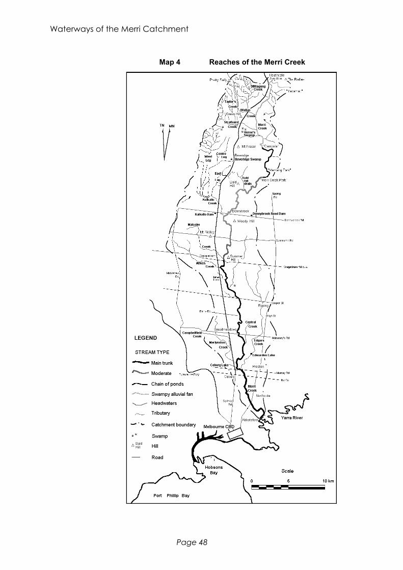
Waterways of the Merri Catchment
Page 48
Map 4 Reaches of the Merri Creek

State of the Environment Report - Introduction
Page 49
Quaternary alluvium in the valley, west of the Silurian outcrops at Summer Hill, indicates aprior floodplain through which the creek is eroding (Earl, 1974).
As with the previous and the next section, the time taken for this type of environment to formis not clear. It is probably of the order of thousands of years or more.
Main Trunk stream: Craigieburn to the Yarra
Craigie (1994) describes the three reaches of the stream downstream of Craigieburn as major.It is at Craigieburn, that the substantial tributaries of Malcolm and Aitken creeks join theMerri Creek. The creek’s principal feature is the incised valley that it is carving though thebasalt plain over which it flows. The valley deepens as the creek flows south. Downstreamof Cooper Street the valley walls narrow to form a picturesque gorge. At Barry Road thegorge opens out to a small floodplain and the creek deposits some of its sediment load asQuaternary Alluvium (Earl, 1974). Further south, Central Creek joins the Merri Creek belowMahoneys Road and then Merlynston Creek (drain) joins at Carr Street. Shortly after this,the creek flows into Coburg Lake. A little below the weir, Edgars Creek runs into the MerriCreek. All creeks that join the Merri Creek hereafter have been turned into drains.
The channel is in a less than natural state for much of this section, having been increasinglymore modified downstream of Coburg Lake. The nature of these modifications (Earl, 1974)are;
• minor re-alignment during main sewer construction (1965) and later levee constructionbetween Miller Street and Normanby Avenue in Thornbury;
• one bend removed and banks filled (now Northcote Golf Course) as part of bridgeconstruction works (1945) south of Normanby Ave;
• creek straightened (1927) and banks stabilised after flood damage (1954) at AuburnAvenue in Northcote;
• meander removed (1937-38) at Sumner Avenue in Northcote;• banks filled (between mid 1940s and 1950) and stabilised with rocks (1955) and later
levee construction at Merri Park on the east bank in Northcote,• construction of a four metre wide and one metre high grouted rock-walled channel (1927-
29) between St Georges Road and Ramsden Street in Clifton Hill which lasted until the1934 flood.
Since the 1934 flood no major work has been done, apart from clearing and maintenance. Ingeneral, the banks are stable but modifications are causing instability in places.
The flow of the water in the reach from Craigieburn to Cooper Street is mainly slow throughemergent vegetation. From there on, the flow is non-uniform, with runs, glides, riffles andlong pools. The bed material over which the creek flows varies from sandy and gravellythrough to boulder-sized rocks and exposed bedrock (especially upstream of Coburg Lake).The aquatic structure is generally good, however it deteriorates below Coburg Lake.
Over its whole length, in terms of its channel origin, the Merri Creek can be classed as; 37%of the total length of the creek is in a natural state, 51% is natural but has had minormodifications and 12% is natural but with extensive modifications and flow character; theupper 39% of the creek has negligible flow in permanent pools; the middle 31% has water

Waterways of the Merri Catchment
Page 50
flowing slowly through emergent vegetation; and the lower 30% is a slow, non-uniformlyflowing stream.
3.3.2 Summaries of the Significant Tributaries
This summary is based on the work of N.M. Craigie & Associates (Craigie, 1994). Theydivide each stream into a series of reaches based on generally similar features such aschannel, bank and verge characteristics. This section deals with the channel origin and theflow character alone and lists the creeks as they join the Merri Creek from its headwaters toits mouth.
It is worth noting that N.M. Craigie & Associates acknowledge that the classification of thecatchment in this manner is quite broad and can be refined by more detailed study. However,this is the best available work that covers the whole watershed.
Mittagong Creek
This creek is the northernmost headwaters of the Merri Creek system but joins Wallan Creekbefore the Merri Creek near the Hume Freeway. Craigie classed it as having only one reach.From its beginnings to its confluence with Wallan Creek, Mittagong Creek is 5 km long.
Although the channel is essentially natural in origin, there has been extensive modification toit. There are several large on-stream dams and the stream from William Street in Wallan toits confluence with Wallan Creek has been straightened somewhat.
The flow is generally negligible but there are disconnected but relatively permanent pools.The dams constructed obviously control the flow.
Wallan Creek
This creek in the headwaters of the Merri Catchment arises on the south side of Pretty Sallyon the Great Dividing Range. It flows south then east through the township of Wallan intothe Merri Creek near Wallan East, a total distance of nearly six kilometres. The creek hasbeen divided into four reaches.
The uppermost reach, which has not been described by Craigie, flows through farmland andthe urban fringe a distance of 1.2 km. It is likely that the form has not been altered much.The sections of the creek downstream of the township, 65% of the total length (5.35 km),have been substantially altered. These alterations include channel enlargement, installation ofa low-flow pipe, channel straightening, channelisation and de-snagging.
The uppermost reach is characterised by a stream flowing slowly through emergentvegetation. The middle reach has not been classified as it has a low-flow pipe. The sectionfrom the Hume Freeway to the Merri Creek does not normally flow but has disconnected andsemi-permanent pools.