stream monitoring -...
TRANSCRIPT

EAPS 312Capstone Environmental Science
Lab #14 Stream MonitoringThe first step in designing a stream monitoring study is to identifying your watershed. The water quality of a stream is influenced by the major land uses in the watershed, the nature of the stream channel, the diversity of stream habitat, and the riparian area surrounding the stream. The watershed is the total area of land that drains into a particular water body. Land uses and runoff in a watershed determine the quality of water in streams and rivers. For example, point source discharges, urban runoff, and runoff from agricultural areas may contain sediments, organic material, nutrients, toxic substances, or bacteria that impact stream water quality.
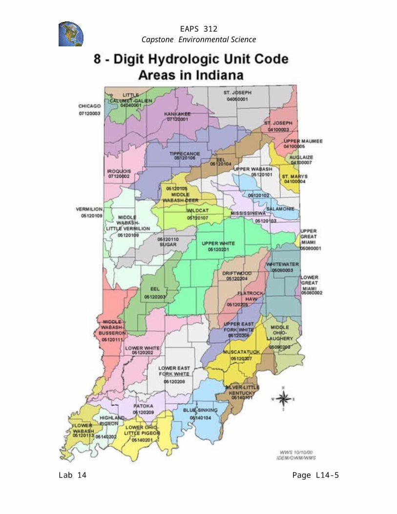
The Lafayette area, Tippecanoe County, is within the Wabash River Basin, which is the largest designated drainage basin in the state and is divided into upper, middle, and lower portions. The Wabash River Basin also extends into Illinois, Indiana, and Ohio, draining approximately 33,000 square miles. The greatest portion of the basin is in Indiana where it drains two-thirds of the state and is divided into subbasins (see HUC Map for Indiana). Burnett Creek, the stream monitoring site, is in the Middle Wabash-Little Vermilion watershed (HUC #05120108).
Trend monitoring is the testing of a stream's water quality on a regular basis, over a period of years. Trend monitoring provides a broad view of the stream allowing the seasonal variations to be sorted out from long-term changes. Furthermore, most stream monitoring programs assess a streams health in three areas: habitat, chemical, and biological quality. Indices are often calculated which provide a score for each monitoring event. The scores provide a simple analysis of the quality of the stream or river site and allow comparisons over time and with other sites.
Habitat Assessment - The condition of the substrate and the land within and adjacent to the stream channel is critical to the health of the stream and its ability to support aquatic life. The Citizens Qualitative Habitat Evaluation Index (CQHEI) utilizes land use, substrate, flow rate, depth, shape, riparian vegetation, and erosion to provide a measure of stream habitat that affects fish and other aquatic life. It includes a map of the monitoring site.
Chemical Assessment - Eight parameters are tested: dissolved oxygen, E. coli, nitrate, total or orthophosphate, turbidity, pH, biochemical oxygen demand, and temperature change. The results of these tests are combined and weighted to determine a Water Quality Index value.
Biological Assessment - Benthic macroinvertebrates are animals that are big enough (macro) to be seen with the naked eye. They lack backbones (invertebrate) and live at least part of their lives in or on the bottom (benthos) of a body of water. Macroinvertebrates include aquatic insects (such as mayflies, stoneflies, and beetles), snails, worms, freshwater clams and mussels, and crayfish. Biological assessment is based on the fact that different species tolerate pollution in different ways.
Lab 14 Page L14-1

EAPS 312Capstone Environmental Science
This lab activity (field trip) will provide some practice for you in monitoring stream quality. You will use the procedures and protocols developed by the Hoosier Riverwatch program. Hoosier Riverwatch promotes stewardship of Indiana's waterways through a volunteer stream monitoring and water quality education program. Riverwatch is supported by the Indiana Department of Natural Resources, Division of Soil Conservation in cooperation with Purdue University. The web site for the Hoosier Riverwatch program is: http://www.state.in.us/dnr/soilcons/riverwatch/. The Hoosier Riverwatch stream monitoring manual web site is: http://www.in.gov/dnr/soilcons/riverwatch/vsm/manual.html.
We are grateful to and acknowledge the Hoosier Riverwatch program for the forms included in this lab activity.
NOTE: bring, wear, knee high boots or old shoes, clothing that can get wet and dirty, and appropriate weather gear. Long sleeved shirts and pants are recommended as poison ivy is found along the stream bank. The field trip will be conducted rain or shine.
Think about it:
Based on the HUC map what is the HUC code for the Lafayette area?
What land use practices might be found within the watershed surrounding Burnett Creek?
How might this land use practices impact the water quality of Burnett Creek?
Monitoring Burnett Creek
At Burnett Creek you will conduct The Citizens Qualitative Habitat Evaluation Index (CQHEI) to assess the stream’s habitat and surrounding land area. You will use Green Kits to assess the chemical parameters. D-nets and kick nets will be used to collect macroinvertebrates for identification and biological assessment. Procedures and protocols will be covered at Burnett Creek. Be sure and bring the forms found in the appendix.
Lab 14 Page L14-2

EAPS 312Capstone Environmental Science
Lab 14 Page L14-3

EAPS 312Capstone Environmental Science
Reflection Questions
The Next Generation Science Standards (NGSS) state that students need experiences learning science in the natural world, conducting investigations and collecting data in the field (i.e., outside the laboratory and classroom). How did this stream investigation engage you in learning science?
The NGSS emphasize engaging all students in science practices. The NGSS argues that “engaging in the practices of science helps students understand how scientific knowledge develops; such direct involvement gives them an appreciation of the wide range of approaches that are used to investigate, model, and explain the world.” Explain how this investigation does and does not engage students in the science practices.
Lab 14 Page L14-4
NGSSScience Practices for K-12 Classrooms
1. Asking questions2. Developing and using models3. Planning and carrying out investigations4. Analyzing and interpreting data5. Using mathematics and computational
thinking6. Constructing explanations7. Engaging in argument from evidence8. Obtaining, evaluating, and
communicating information
EAPS 312Capstone Environmental Science
Appendix
Lab 14 Page L14-5

EAPS 312Capstone Environmental Science
Lab 14 Page L14-6

EAPS 312Capstone Environmental Science
Lab 14 Page L14-7

EAPS 312Capstone Environmental Science
Lab 14 Page L14-8

EAPS 312Capstone Environmental Science
Lab 14 Page L14-9

EAPS 312Capstone Environmental Science
Lab 14 Page L14-10

EAPS 312Capstone Environmental Science
Lab 14 Page L14-11

EAPS 312Capstone Environmental Science
Lab 14 Page L14-12

EAPS 312Capstone Environmental Science
Lab 14 Page L14-13

EAPS 312Capstone Environmental Science
Lab 14 Page L14-14

EAPS 312Capstone Environmental Science
Lab 14 Page L14-15