streams & floods: the geology of running water
TRANSCRIPT
Streams & Floods: The Geology of Running Water
• Earth is unique in that it is the only place in our solar system that contains streams of running water.
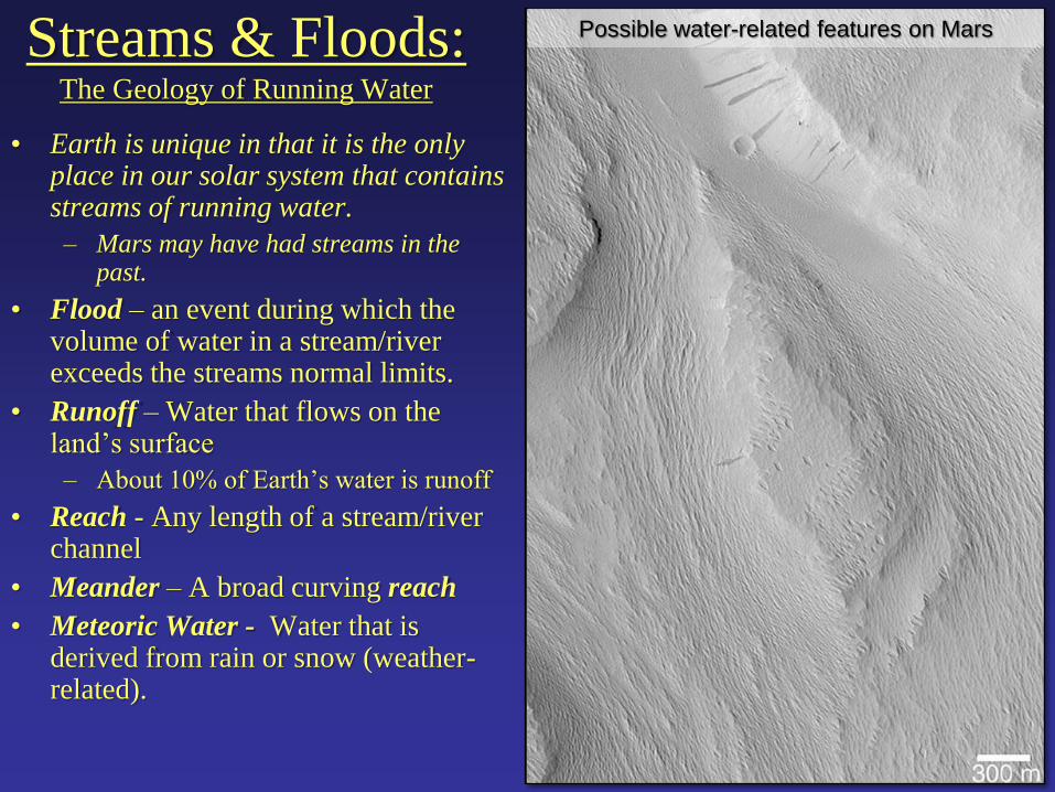
– Mars may have had streams in the past.
• Flood – an event during which the volume of water in a stream/river exceeds the streams normal limits.
• Runoff – Water that flows on the land’s surface
– About 10% of Earth’s water is runoff
• Reach - Any length of a stream/river channel
• Meander – A broad curving reach
• Meteoric Water - Water that is derived from rain or snow (weather-related).
Possible water-related features on Mars
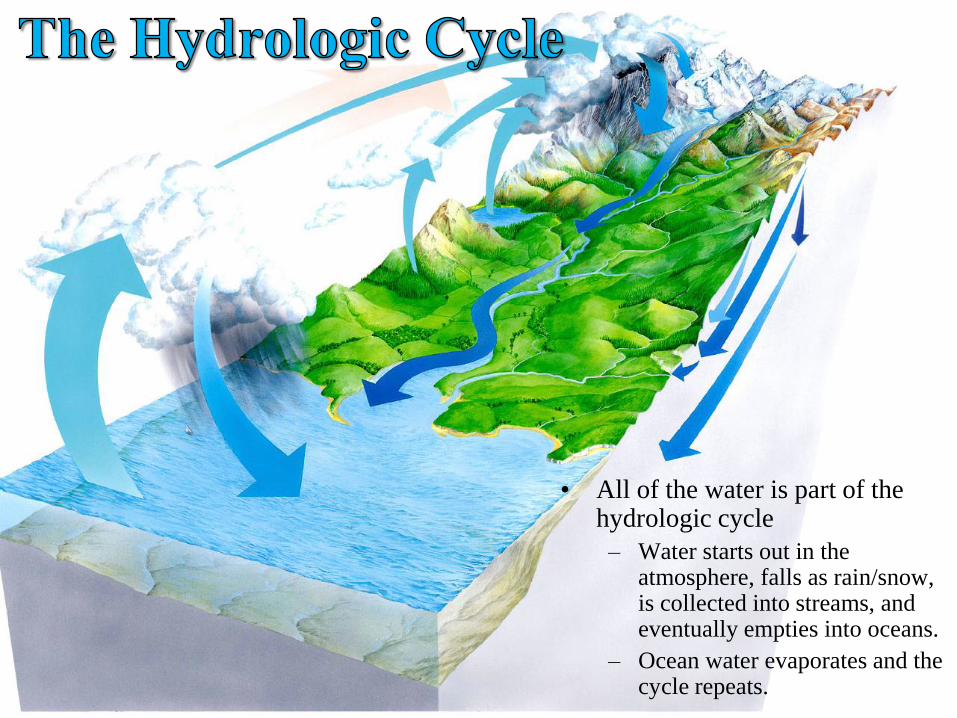
• All of the water is part of the hydrologic cycle
– Water starts out in the atmosphere, falls as rain/snow, is collected into streams, and eventually empties into oceans.
– Ocean water evaporates and the cycle repeats.
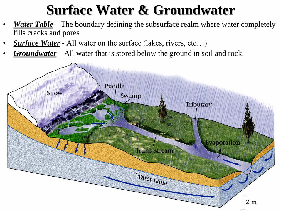
Surface Water & Groundwater • Water Table – The boundary defining the subsurface realm where water completely
fills cracks and pores
• Surface Water - All water on the surface (lakes, rivers, etc…)
• Groundwater – All water that is stored below the ground in soil and rock.

Forming Streams • Running water begins as Sheetwash, a
film of water a few mm thick. (like water on a road)
• Sheetwash erodes its substrate (the solid base layer it rests upon)
• The rate of erosion depends on velocity, strength of substrate, and amount of vegetation (strength of substrate)
• Eventually the sheetwash forms a channel in the weaker portions of the substrate and the channel is eroded deeper with time by Downcutting, eventually forming a stream.
• As flow increases, Headward Erosion (i.e. erosion in an upstream direction) occurs because flow is faster at the entry to the channel.
• With passing time, other Tributaries may link together to a main Trunk Stream.

Drainage Networks • Interconnecting
tributaries form a
Drainage Network.
• They come in several
flavors:

Drainage Basins and Divides • The area drained by a system of tributaries is called a Drainage Basin,
Catchment, or Watershed.
• A high ridge that separates one water shed from another is called a Divide.

Divides and Watersheds in the U.S.
• Watersheds exist in
a variety of scales.
– Tiny tributaries.
– Continental rivers.
• Large watersheds…
– Feed large rivers.
– Section continents.
• Continental divides
separate flow to
different oceans.

Permanent vs. Ephemeral Streams • Some streams flow all year,
and some do not.
• Permanent Stream – A
stream that has a base that is
below the water table and so
it flows all year
– Usually found in temperate
climates
• Ephemeral Stream – A
stream that only flows after
rainfall events. The water
eventually flows into the
ground.
– Found in arid climates
• A dry ephemeral stream bed
is caled a Wash

Stream Discharge • Geologists measure the amount of water that a stream carries by measuring its
discharge.
• Discharge – The volume of water that passes through an imaginary cross section
across a stream. Expressed at some volume per time e.g. meters3/second
• Discharge varies widely
• Amazon ~ 200,000 m3/s
– largest discharge on
Earth
– ~15% of total runoff on
Earth
• Congo ~ 40,000 m3/s
• Mississippi ~ 17,000 m3/s
• In arid regions discharge
decreases away from source
• In temperate regions
discharge increases away
from source
• Can also vary due to
seasons, or human activity

Stream Velocity • The average velocity of a stream is
difficult to measure because flow in
streams is complex.
• Friction along the sides and bottom of
stream channels slows the water’s
velocity
• The smaller the Wetted Perimeter
(assuming the cross sectional area is
the same), the faster the water can
flow.
• Streams with meanders will have the
fastest velocity and deepest depth at
the outer banks (Thalwegs) of the
meanders.
• Crescent shaped Point Bars may
form on the inner banks of meanders.

Turbulent Flow • Complex
interactions with
underwater
boulders and the
stream banks cause
Turbulent Flow,
i.e. flow that is
complex and not
all in the same
direction
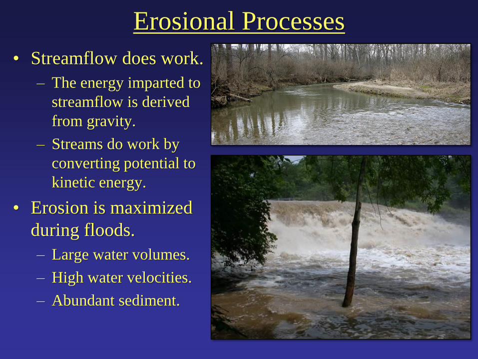
Erosional Processes
• Streamflow does work.
– The energy imparted to
streamflow is derived
from gravity.
– Streams do work by
converting potential to
kinetic energy.
• Erosion is maximized
during floods.
– Large water volumes.
– High water velocities.
– Abundant sediment.
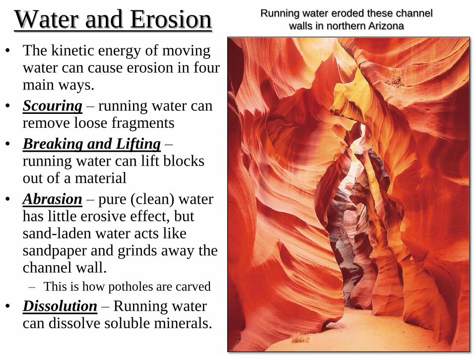
Water and Erosion • The kinetic energy of moving
water can cause erosion in four main ways.
• Scouring – running water can remove loose fragments
• Breaking and Lifting – running water can lift blocks out of a material
• Abrasion – pure (clean) water has little erosive effect, but sand-laden water acts like sandpaper and grinds away the channel wall.
– This is how potholes are carved
• Dissolution – Running water can dissolve soluble minerals.
Running water eroded these channel
walls in northern Arizona

Transportation and Sediment Load • Sediment Load – The amount of sediment that a stream carries. It consists of
• Dissolved Load – ions floating in the water solution
• Suspended Load – sediment (silt & clay) that is suspended (no settling) within the stream
• Bed Load – Larger particles that bounce or roll along the stream floor.
– Moves by Saltation, bouncing an rolling along the stream floor.
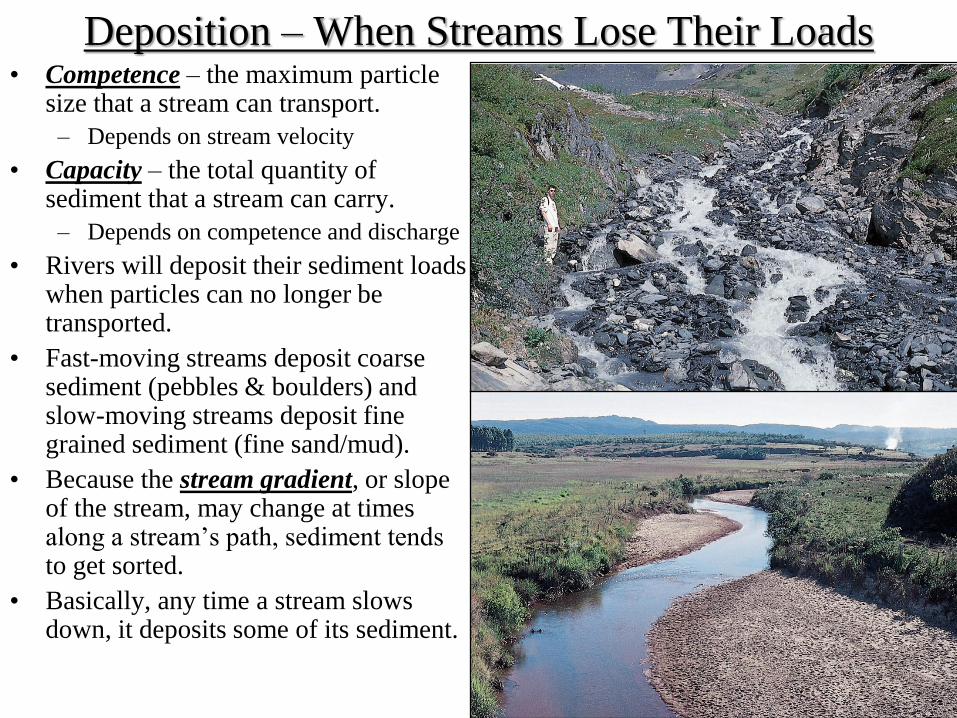
Deposition – When Streams Lose Their Loads • Competence – the maximum particle
size that a stream can transport.
– Depends on stream velocity
• Capacity – the total quantity of sediment that a stream can carry.
– Depends on competence and discharge
• Rivers will deposit their sediment loads when particles can no longer be transported.
• Fast-moving streams deposit coarse sediment (pebbles & boulders) and slow-moving streams deposit fine grained sediment (fine sand/mud).
• Because the stream gradient, or slope of the stream, may change at times along a stream’s path, sediment tends to get sorted.
• Basically, any time a stream slows down, it deposits some of its sediment.
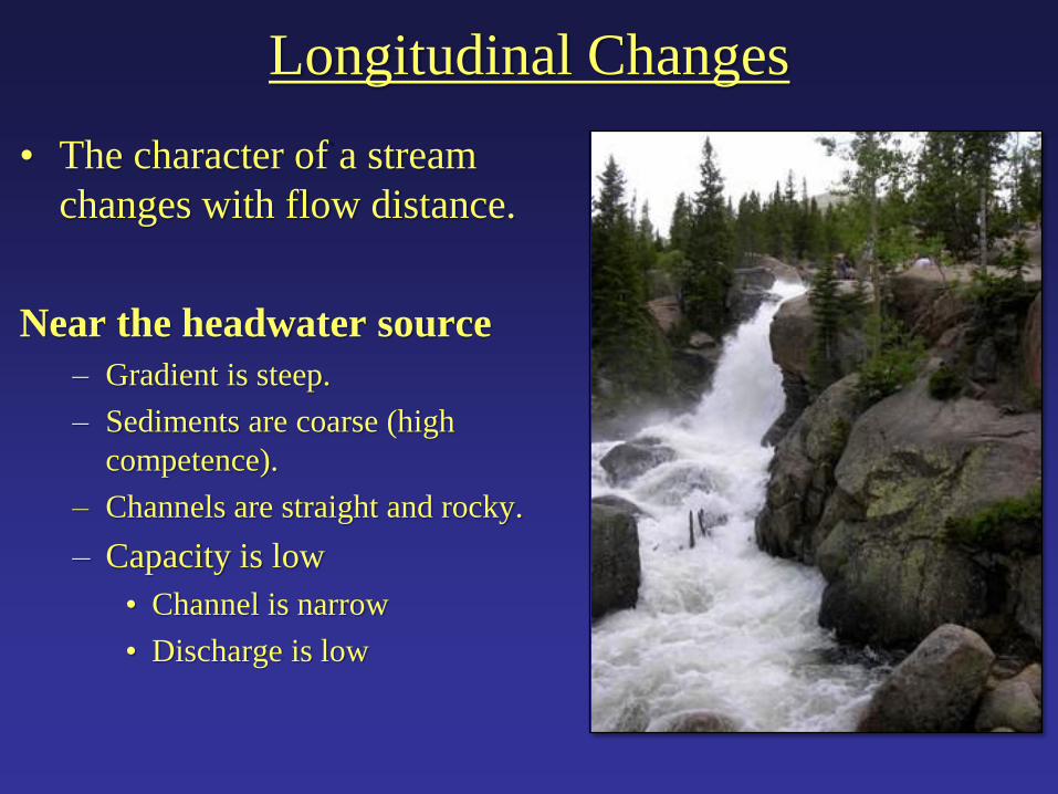
Longitudinal Changes
• The character of a stream
changes with flow distance.
Near the headwater source
– Gradient is steep.
– Sediments are coarse (high
competence).
– Channels are straight and rocky.
– Capacity is low
• Channel is narrow
• Discharge is low

Longitudinal Changes
• The character of a stream changes with flow distance.
– Towards the mouth*… *(where a river enters the ocean)
• Gradient flattens.
• Higher discharges. (Channel is wider)
• Smaller grain sizes typical (low competence).
• Channels carve broad meander belts.

Longitudinal Stream Profile

Base Level
• There is a depth below
which a stream cannot
cut. This is called the
Base Level.
• Base levels can be
local (e.g. a lake) but
all streams have the
ultimate base level of
sea level.
• Local base levels can
be removed over long
periods of time

Stream Valleys and Canyons • If a stream downcuts faster
than erosion of the channel walls, it will form narrow Slot Canyons (e.g. Zion).
• If a stream downcuts slowly, erosion of the channel walls will form a V-Shaped Valley (e.g. New river).
• If a stream cuts through rocks of contrasting strengths (sandstone vs. shale) it may form a valley with a stair-step shape (e.g. Grand Canyon).

Stream Terraces
• If base levels change or if
discharge changes a stream can
form multiple Terraces within
an alluvium-filled valley.

Waterfalls and Rapids • Rapids form where water flows over boulders or where a stream’s
gradient increases
• Waterfalls form when a streams gradient becomes very steep, possibly
due to a resistant layer at its base (Niagara Falls).
• Waterfalls slowly change due to headward erosion. A good example
of this is Niagara Falls…
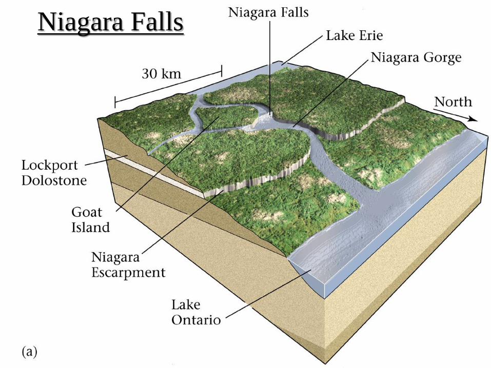
Niagara Falls

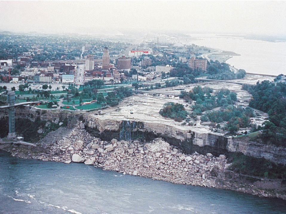

Headward Erosion at Niagara Falls
• Geologists studied the headward erosion of Niagara Falls and determined that the fall is eroded back towards Lake Erie by ~1 m / year
• Now, it is about half that because some water is diverted for hydro-electric power.
• In ~60,000 yrs, the falls will erode all the way back to Lake Erie

Alluvial Fans • Alluvial Fans form where a fast-moving mountain stream emerges
from a canyon at the range front onto an open plain.
• The water was once confined to a narrow channel can now spread out
• Because of this its flow slows and it deposits its sediment load in a fan shape.
• Common in arid
Environments with
much topography
• Typically
consists of sand &
cobbles
• Rock Types:
Arkose/Sandstone
Breccia
The Badwater fan in Death Valley

Braided Streams • In some locations, streams carry abundant coarse sediment during storms but cannot
carry this sediment during normal flow.
• During normal flow the sediment is deposited and the stream divides into numerous
meandering channels forming a Braided Stream.
• Because of the large amount of sediment that is deposited,
braided streams cannot
cut deep channels
(loose sediment is weak).
• Common to
glacially-fed streams
A braided stream
In Alaska

Meanders • Where rivers flow over relatively flat land comprised of a relatively
soft substrate, natural variations in the substrate strength and the
velocity of the water will cause the channel to begin to form curved
segments called meanders.
• Once the meander sweeps through ~180° the meander neck, may
continue to be eroded by the cut bank.
• Eventually the river’s cut bank may erode through the meander neck,
leaving an abandoned, meander called an Oxbow Lake.
TIME


Flood Plains & Levees • A meandering
stream occupies only
a small portion of a
greater flood plain,
which is inundated
during a large flood
event.
• Water spilling out
from the edges of a
river forms a
natural levee.
• The levee can
sometimes grow so
high that the river
bottom is higher
than the flood plain.
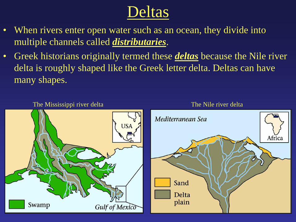
Deltas • When rivers enter open water such as an ocean, they divide into
multiple channels called distributaries.
• Greek historians originally termed these deltas because the Nile river
delta is roughly shaped like the Greek letter delta. Deltas can have
many shapes.
The Mississippi river delta The Nile river delta

Midstream Bars & Avulsion Why do distributaries form?
• When a river enters standing water, the water in the middle of the channel is moving
fastest, so it is carrying the most sediment.
• Therefore, the most deposition occurs in the middle of the main channel, forming a
Midstream Bar and choking off the river and forcing it to split into Distributaries.
• Eventually, the midstream bar may grow so large it totally blocks the flow of the river.
• This causes Avulsion, whereby the river will get deeper and eventually break the Natural Levee at an upstream location.
• Now the river will enter the standing water at a new location causing a new delta to form.

The Migrating Mississippi Delta
• Avulsion has caused the Mississippi
river delta to migrate through time.
Engineers now help keep the river on
its present day track so that it still
flows through New Orleans.
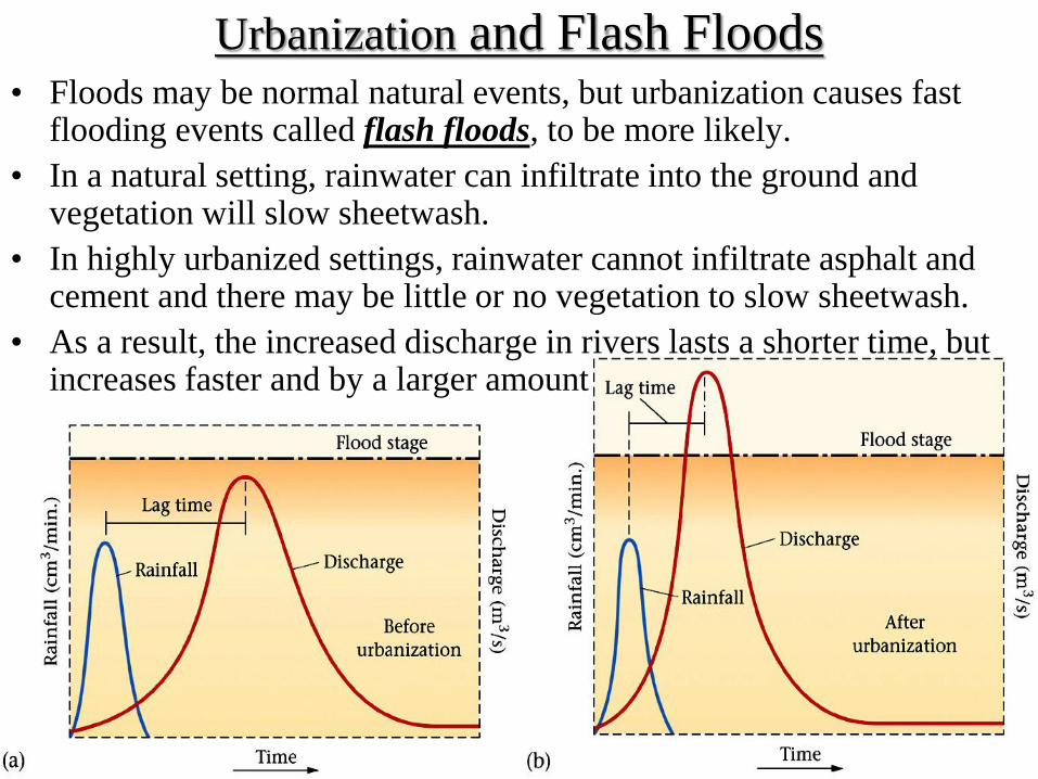
Urbanization and Flash Floods • Floods may be normal natural events, but urbanization causes fast
flooding events called flash floods, to be more likely.
• In a natural setting, rainwater can infiltrate into the ground and vegetation will slow sheetwash.
• In highly urbanized settings, rainwater cannot infiltrate asphalt and cement and there may be little or no vegetation to slow sheetwash.
• As a result, the increased discharge in rivers lasts a shorter time, but increases faster and by a larger amount