structural approaches to managing flooding and flood...
TRANSCRIPT

@fhrc_mdx
Structural approaches to managing flooding and flood defence management
Dr Simon McCarthy
PRS4526 Flood Risk Management 2014/2015

Learning outcomes
• An understanding of the role of flood defences in the wider FRM
• Appreciation of the range of different types of defences and their roles
• An understanding of maintenance issues and related defence conditions
• An appreciation of the importance of information system in the management process
PRS4526 Flood Risk Management 2014/2015

Lecture overview
The Concepts – UK case
Structural Approaches – not engineering construction
(CIRIA guidance)
Maintenance – management approach
Seminar – condition grading and Lower Thames Scheme
PRS4526 Flood Risk Management 2014/2015

@fhrc_mdx
The Concepts

Flood Management infrastructure - concepts
PRS4526 Flood Risk Management 2014/2015

PRS4526 Flood Risk Management 2014/2015
Source – Pathway – Receptor – Consequence (S-P-R-C) Model
Flood Management infrastructure - concepts

PRS4526 Flood Risk Management 2014/2015
Risk based FRM Decisions
• Rely on Appropriate Quality S-P-R-C Data e.g.
o Gauging flows (Source)
o Asset condition/Crest Levels (Pathway)
o Land Use (Receptor)
o Damage to Property, people and the environment (Consequence)
Gauging Venice & Vicenca Italy

Defending what?
PRS4526 Flood Risk Management 2014/2015
A flooded Cockermouth high street in 2009, Cumbria. Photo by: Owen
Humphreys/PA (Source: the Guardian) Aerial view residential flooding - Cockermouth, Cumbria © Environment Agency
Receptor & Consequences
Residential and businesses
People and livelihoods
Social and Economic disruption
Loss of life Flooding river in Cornwall, 2010 (Source: www.onegeology.org )
Agriculture

Electricity Gas
Water supply Wastewater
Utilities infrastructure and related services
Water supply reaches Gloucestershire after floods in
2007 ©BBC
Photo by Andy Rain/EPA (Source: The Guardian)
Waste water evaporation pits in Wyoming © Ted
Wood/ Corbis (Source: The Guardian)
Photo PA (Source: The Telegraph)
Defending what?
PRS4526 Flood Risk Management 2014/2015

Schools Hospitals
Emergency
services
Other critical
infrastructure
Flooded School - Stockton-on-tees in Durham © Environment Agency
© Environment Agency
Worthing Hospital, June 2012 © Daily Mail
British Airways aircaraft takes off at a wet and rainy
Heathrow airport in London, December 2013 © Andy
Rain/EPA (Source: the Guardian)
Defending what?
PRS4526 Flood Risk Management 2014/2015
Public building &
services and
Staff / personnel

Road networks Rail networks
Telecommunications
Flooding in Workington, November 2009 © Environment Agency Saltcoats in Scotland © PA (taken from www.telegraph.co.uk)
BT Tower image (Source; TimeOut London)
Defending what?
PRS4526 Flood Risk Management 2014/2015
Networks

Issues of Responsibility – who owns the flood defence
PRS4526 Flood Risk Management 2014/2015
“A flood defence asset is defined as an asset that would, by its failure, increase the LIKELIHOOD of flooding from (main) river or the sea to people, property and infrastructure”
Property excludes gardens but includes agricultural land and Habitats Directive Sites
Infrastructure includes Roads, Public Rights of Way and Railways
Environment Agency UK definition
How are the responsibilities defined?
Who has responsibility for non main river and surface water / ground
water / sewer flooding?

PRS4526 Flood Risk Management 2014/2015
Flood Management infrastructure - concepts

@fhrc_mdx
Structural Approaches

PRS4526 Flood Risk Management 2014/2015
Flood Characteristics
Occurrence of the hazard event
- Speed of onset: sudden, slow or creeping
- Frequency or return period
- Size
- History
Impact
- Area: Focused or diffuse
- Intensity
- Immediacy and duration
Is defence infrastructure appropriate or possible?

PRS4526 Flood Risk Management 2014/2015
Upper Trent Systems Tamworth System
Flood Risk Management System

PRS4526 Flood Risk Management 2014/2015
River
Sea and River
Sea
Weirs Culverts
Debris
screens
Channels
Embankments
Structures
Revetments
Flood gates
Barriers
Bridges
Demountables
Outfalls
Flaps
Sluice
Property
Level
Protection
Seawalls
Beaches
Groynes
Dunes
Saltmarsh
Outfalls
Defence Infrastructure Components
PRS4526 Flood Risk Management 2014/2015
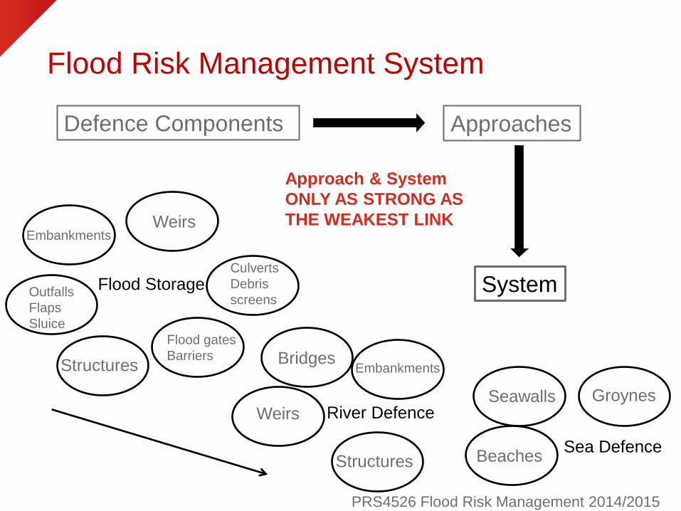
Flood Risk Management System
Defence Components Approaches
Flood Storage
Weirs
Culverts
Debris
screens
Embankments
Structures
Outfalls
Flaps
Sluice
Flood gates
Barriers
System
Sea Defence
Seawalls
Beaches
Groynes Weirs
Embankments
Structures
Bridges
River Defence
Approach & System
ONLY AS STRONG AS
THE WEAKEST LINK

River
PRS4526 Flood Risk Management 2014/2015
Weir System Vicenca Italy
Culvert Cringle Brook
Channel Doncaster
Channel Vicenca
Italy Trash / Debris screen
Basingstoke

Sea and River
PRS4526 Flood Risk Management 2014/2015
Sluice gate flood storage
area Todmorden
Embankment Millward
flood storage area
Flap Valves Northampton Embankment River Don Revetment Santos Brazil
Revetment Thames

PRS4526 Flood Risk Management 2014/2015
Sea and River
Structure Wood pile
Thames
Structure brick & mastic
Northampton
Structure Steel pile
Flood Gates & Barriers

PRS4526 Flood Risk Management 2014/2015
Sea and River Demontables
Brick design Vicenca
© Environment Agency
• Who is protected?
• Responsibility for building?
• Access to build in emergency?
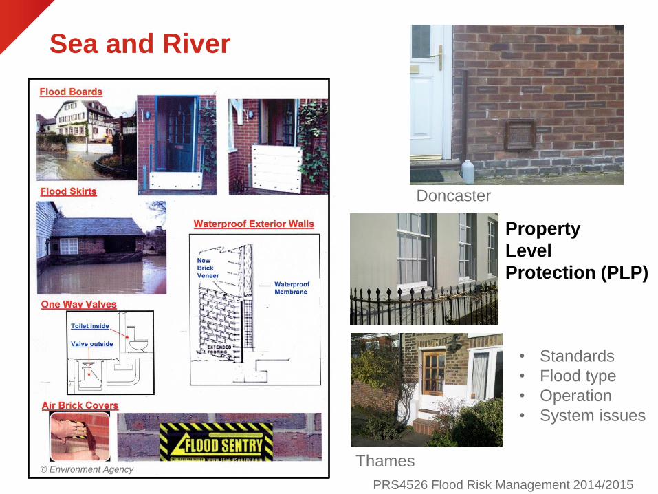
Sea and River
PRS4526 Flood Risk Management 2014/2015
© Environment Agency
Property
Level
Protection (PLP)
Doncaster
Thames
• Standards
• Flood type
• Operation
• System issues
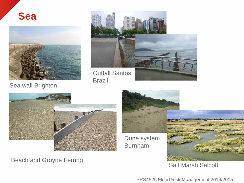
Sea
PRS4526 Flood Risk Management 2014/2015
Beach and Groyne Ferring
Sea wall Brighton
Dune system
Burnham
Outfall Santos
Brazil
Salt Marsh Salcott

Additional FRM ‘defence’ Approaches
PRS4526 Flood Risk Management 2014/2015
Managed Re-Alignment
(Humber estuary)
Cambridge reed planting
Farming practices
Flood storage
Soft / green defences
Sustainable Urban Drainage (Week 22)
Dredging
Diversion channels
Pumping
Managed re-alignment
River restoration
Lode pumping station

River Restoration techniques
PRS4526 Flood Risk Management 2014/2015

@fhrc_mdx
Maintenance

Maintenance Approach UK
PRS4526 Flood Risk Management 2014/2015
Quantify and Record
• All flood defences: Location, Type, Construction
• Their importance in the system / the system nationally
• Target condition
• Current condition
Provide a single easily accessible and definitive store for all
data on flood and coastal defences with the appropriate tools to
allow manipulation of that data in order that we can understand
flood risk better and so make better informed decisions about
managing defence assets. (Environment Agency)
BUT
If Data Quality and Consistency is poor or poor and not clearly
recognised as such then value to decision making is diminished
and even detrimental

Describe the location
PRS4526 Flood Risk Management 2014/2015

Describe the defence
PRS4526 Flood Risk Management 2014/2015
Channel Side 2
Inward Face 1
Inward
Face 2
Berm 1
Inward Face 3
Flood Crest

PRS4526 Flood Risk Management 2014/2015
Describe the defence
Outward
Face 1
Berm 2 0utward
Face 2 Berm 3
Outward Face 3

PRS4526 Flood Risk Management 2014/2015
Describe the defence
Flood Level
MHW
MLW
Sea Bed Channel Side 1
Channel Side 2
Inward Face 1
Berm1
Inward Face 2
Flood Crest
Outward Face 1
Berm 2
Outward Face 2
Berm 3
Outward Face 3
• Weighting factors

PRS4526 Flood Risk Management 2014/2015
Full classification for any combination of defence
Describe the defence

PRS4526 Flood Risk Management 2014/2015
Grade Rating Description
1 Very Good Cosmetic defects that will have no
effect on performance
2 Good Minor defects that will not reduce the
overall performance of the asset
3 Fair Defects that could reduce performance
of the asset
4 Poor Defects that would significantly reduce
the performance of the asset. Further
investigation needed.
5 Very Poor Severe defects resulting in complete
performance failure
Describe the condition • Visual inspection. Frequency dependant on risk matrix.
• Every element of every defence
• Description and pictures for every element for consistency
• System failure not related to length or type defence

Defended Height and Design Standard
PRS4526 Flood Risk Management 2014/2015
Boston UK
Burnham splash wall
Access Point

Forecasting Failure
PRS4526 Flood Risk Management 2014/2015
Narrow turf embankment
0.0
0.1
0.2
0.3
0.4
0.5
0.6
0.7
0.8
0.9
1.0
-1.25 -0.75 -0.25 0.25 0.75
Negative freeboard [m]
Pro
ba
bilit
y o
f b
rea
ch
[-]
CG1
CG2
CG3
CG4
CG5
8m wide
Fragility Curve
Environment Agency / Defra (2009).

Describe the risk: Target Condition
PRS4526 Flood Risk Management 2014/2015
HIGH e.g.
LUB A/B or
Habs Regs
sites
HIGH HIGH HIGH HIGH
MEDIUM e.g.
LUB C, or
SSSI's
LOW MEDIUM MEDIUM HIGH
LOW e.g. LUB
D/ELOW LOW LOW MEDIUM
Low-Negligible
risk to life.
Medium- Time
likely to be
available for
evacuation in
event of failure.
High- Little
warning of
flooding to
residential or
commercial
property
Very High- Little
warning of failure.
Possible loss of
life/major injury.
Sudden impact to
vulnerable groups.
e.g.
small/medium
watercourses,
defences
protecting
agricultural land,
Category D FSRs.
e.g. significant
watercourses
without raised
defences,
diversion
channels,
Category C FSRs,
etc
e.g raised
defences.
e.g. very
significant raised
defences or
category A/B FSRs.
Very significant
structures.
Imp
act
of
flo
od
ing
Analysing the Consequence of Failure of an FRM System
Potential Impact on People from System Failure
1 2 3 4
5 6 7 8
9 10 11 12
Environment Agency / Defra (2009).

Defence Record
PRS4526 Flood Risk Management 2014/2015

Example UK Data Management System
PRS4526 Flood Risk Management 2014/2015
Historic example of the Environment Agency
National Flood and Coastal Defence Database ( © Environment Agency)

Maintenance & Inspection
PRS4526 Flood Risk Management 2014/2015
Visual impeded Northampton
Access Wick St Lawrence
Animal burrows
• Regular visual inspections
• Engineering inspections if required
• Post event inspections

PRS4526 Flood Risk Management 2014/2015
Cleared? River Wye Functionality
Romsey Danes
Sea defences
Clevedon & Swanscombe Rotation
Wick St Laurence
Lock Gates Cambridge
Crest erosion Kelvedon
Maintenance & Inspection
Blockage Doncaster

Culvert Inspections
PRS4526 Flood Risk Management 2014/2015
Culvert blockage West Garforth
Integrated Urban Drainage Pilot Newsletter 2007
Inception Report 2007

Maintenance vs Environment
PRS4526 Flood Risk Management 2014/2015
Margin habitat Poor Margin habitat

PRS4526 Flood Risk Management 2014/2015
Building in Community Ownership
Visibility
Engagement

The Swan hotel at Upton upon Severn (© Environment Agency)
Building in Community Ownership
PRS4526 Flood Risk Management 2014/2015

Learning outcomes
• An understanding of the role of flood defences in the wider FRM
• Appreciation of the range of different types of defences and their roles
• An understanding of maintenance issues and related defence conditions
• An appreciation of the importance of information system in the management process
PRS4526 Flood Risk Management 2014/2015

@fhrc_mdx
Seminar

• Environment Agency / Defra (2009). Guidance on determining asset deterioration and the use of condition grade deterioration curves. Product Code: SCHO0509BQAT-E-P
• Environment Agency. (2008) Condition Assessment Manual (CAM). Environment Agency: Bristol.
• Ciria (2014). International Levee Handbook. http://www.ciria.org/service/ILH download
• Hall, J.M., Hockin, D.L., Ellis, J.B. (1993). Design of flood storage reservoirs. CIRIA
• Penning-Rowsell, E.C., Johnson, C., Tunstall, S., Tapsell, S., Morris, J., Chatterton, J., and Green, C. (2005) The Benefits of Flood and Coastal Risk Management: A Manual of Assessment Techniques, Middlesex University Press, London.
PRS4526 Flood Risk Management 2014/2015
References

PRS4526 Flood Risk Management 2014/2015
Slide references– Licenses Slide License/Source
5/6 a. FLOODsite (2009) Flood risk assessment and flood risk management. An introduction and guidance based on experiences and
findings of FLOODsite (an EU-funded Project. Deltares / Delft Hydraulics, Delft, the Netherlands. Publically available Report Number
T29-09-01 Ed.2, available at: http://www.floodsite.net/html/publications2.asp?documentType=1&Submit=View
b. Diagram redeveloped learning from Parker, D.J. (ed.), 2000. Floods. Volumes I and II. Routledge, London
7 Photographs by Simon McCarthy as part of the WeSenseIt project Italy.
12 Photographs by Simon McCarthy as part of the WeSenseIt project Doncaster culvert & personal picture Thames.
16 Maps adapted from teaching materials provided by and permission given to reproduce by John Chatterton
19 Photographs by Simon McCarthy as part of the WeSenseIt project: Doncaster and Vicenca
Photographs by John Chatterton private collection Cringle and Basingstoke
20 Photographs by Simon McCarthy as part of the WeSenseIt project and private collection : Don, Santos and Thames
Photographs by John Chatterton private collection Northampton, Millward and Todmorden
21 Photographs by Simon McCarthy as part of the WeSenseIt project and private collection : Northampton and Thames
Photographs by John Chatterton private collection flood gates and structure steel
22 Photograph by Simon McCarthy as part of the WeSenseIt project Italy
23 Photographs by Simon McCarthy as part of the WeSenseIt project and private collection : Doncaster and Thames
24 Photographs by Simon McCarthy as private collection : Santos and Brighton
Photographs by John Chatterton private collection Burnham and Ferring
Photograph Salt marsh creative commons Matthew Baker
25 Photographs by John Chatterton private collection flood gates and structure steel
26 http://thebritishgeographer.weebly.com/floods-and-river-management.html
29-34 Training materials created by John Chatterton and reproduced with permission. Photographs by John Chatterton private collection

PRS4526 Flood Risk Management 2014/2015
Slide references– Licenses Slide License/Source
35 Photographs by John Chatterton private collection
40 Photographs by Simon McCarthy private collection
Photographs by John Chatterton private collection Northampton, St Lawrence, animal burrows
41 Photographs by John Chatterton private collection
43 Photographs by John Chatterton private collection
44 Photographs by Simon McCarthy as part of the WeSenseIt project: Doncaster - engagement
Visibility: Nar flood storage reservoir (Norfolk); attribution Martin Pearman. This file is licensed under the Creative Commons
Attribution-Share Alike 2.0 Generic License. Available from http://commons.wikimedia.org/wiki/File:Nar_Flood_Storage_Reservoir_-
_geograph.org.uk_-_1224129.jpg
Visibility: Richard Allaway Frankwell Flood Defences
https://www.flickr.com/photos/geographyalltheway_photos/2996432907/in/photolist-5yMv7k-5yRGY1-5yRJb3-5yRLrs-5yMuy2-
5yMsRe-5yRQi7-5yMtbp-5yMrEi-5yRPYd-5yRRnQ-5yMqGV-5yMx42-5yRQCN-icLGya-6NwBpX-ac5Ucz-iV4bsC-iV5Wnm-iV3nhz-
ezCiEo-edDJWC-bTLNag-4W9kHN-bERZjs-81ENa4-bGQxmc-8SAG5C-vgbm6-bNR1Ma-knNHpC-bCFjo7-ivZP5v-3uStBq-8JeZkw-
xaPuT-xaPuU-8JeYnE-8JbTzF-ckGs29-7KR9vw-io2c2f-apsemw-9bhWh2-dE6zvr-dE6Bvg-dEbZ9J-dEbYKh-dEbYjj-dE6AP8
20 Photographs by Simon McCarthy as part of the WeSenseIt project and private collection : Don, Santos and Thames
Photographs by John Chatterton private collection Northampton, Millward and Todmorden
21 Photographs by Simon McCarthy as part of the WeSenseIt project and private collection : Northampton and Thames
Photographs by John Chatterton private collection flood gates and structure steel
22 Photograph by Simon McCarthy as part of the WeSenseIt project Italy
23 Photographs by Simon McCarthy as part of the WeSenseIt project and private collection : Doncaster and Thames
24 Photographs by Simon McCarthy as private collection : Santos and Brighton
Photographs by John Chatterton private collection Burnham and Ferring
Photograph Salt marsh creative commons Matthew Baker
25 Photographs by John Chatterton private collection flood gates and structure steel
26 http://thebritishgeographer.weebly.com/floods-and-river-management.html
29-34 Training materials created by John Chatterton and reproduced with permission. Photographs by John Chatterton private collection