structural suite draft -...
TRANSCRIPT

3DS.
COM
© Da
ssau
ltSys
tèmes
| Con
fiden
tial In
forma
tion
| 6/1/
2018
| ref.
: 3DS
_Doc
umen
t_201
5
Surpac 6.9 and the Structural Suite
Tony NykielApplication manager

2
3DS.
COM/
GEOV
IA©
Dass
aultS
ystèm
es| C
onfid
entia
l Infor
matio
n | 6
/1/20
18| r
ef.: 3
DS_D
ocum
ent_2
015
What geotechnical information can be used and processed
Who is responsible for collection and analysis
Why is it important to analyse geotechnical info
When is it available – Surpac 6.9
Workflows – examples of usage
Increase your geotechnical understanding of your mine operation with Surpac 6.9 Structural Suite

3
3DS.
COM/
GEOV
IA©
Dass
aultS
ystèm
es| C
onfid
entia
l Infor
matio
n | 6
/1/20
18| r
ef.: 3
DS_D
ocum
ent_2
015
Increase your geotechnical understanding of your mine operation with Surpac 6.9 Structural Suite
MineSurvey
Mine Planning
GeologyGeotech(ground
engineering)
Hydrogeology
Geotechnical study is a discipline that uses both geological and engineering measurements and analysis to provide information to make decisions that provide a safe and productive mine environment.

4
3DS.
COM/
GEOV
IA©
Dass
aultS
ystèm
es| C
onfid
entia
l Infor
matio
n | 6
/1/20
18| r
ef.: 3
DS_D
ocum
ent_2
015
Structural Suite for GEOVIA Surpac at glance Visualization and analysis tools for almost any kind of oriented data ~20 tools in current version Structural Suite enables you to: include 3D orientation data to geological modelling workflow, usingbedding, joints, foliation etc.structural modelling in Surpac using all available data, such as joint orientations from
core logging, mapped structure data

5
3DS.
COM/
GEOV
IA©
Dass
aultS
ystèm
es| C
onfid
entia
l Infor
matio
n | 6
/1/20
18| r
ef.: 3
DS_D
ocum
ent_2
015
All tools available from installed toolbarsTwo main toolbars:1. Structural Suite toolbar for Visualising a n d general
tools2. StereographicTools toolbar for working with
stereographic projections
Copy Tools have been integrated to Core Surpac.

6
3DS.
COM/
GEOV
IA©
Dass
aultS
ystèm
es| C
onfid
entia
l Infor
matio
n | 6
/1/20
18| r
ef.: 3
DS_D
ocum
ent_2
015
Visualising structural data – data source POINT or DISCRETE type data can be visualised from Surpac database Supports dip/dip direction and dip/strike and alpha/beta

7
3DS.
COM/
GEOV
IA©
Dass
aultS
ystèm
es| C
onfid
entia
l Infor
matio
n | 6
/1/20
18| r
ef.: 3
DS_D
ocum
ent_2
015
Visualising structural data – data constraints Data can be constrained by:collar tabledata table values
Examples:Steeply dipping structures in
diamond core holes.Mapping structures with
length > 10m

8
3DS.
COM/
GEOV
IA©
Dass
aultS
ystèm
es| C
onfid
entia
l Infor
matio
n | 6
/1/20
18| r
ef.: 3
DS_D
ocum
ent_2
015
Visualising structural data – symbol styles Simple styling let user quickly select
symbol and symbol size Scale by database attribute 3D mode for real world view of dip 2D mode suitable for plan maps

9
3DS.
COM/
GEOV
IA©
Dass
aultS
ystèm
es| C
onfid
entia
l Infor
matio
n | 6
/1/20
18| r
ef.: 3
DS_D
ocum
ent_2
015
Visualising structural data – symbol stylesAdvanced styling provides more options: Select symbol by database field value Scale symbols using constant values or
mathematical expressions Expressions can contain references to db
fields Scale and offset can be set separately for
X, Y and Z axis

10
3DS.
COM/
GEOV
IA©
Dass
aultS
ystèm
es| C
onfid
entia
l Infor
matio
n | 6
/1/20
18| r
ef.: 3
DS_D
ocum
ent_2
015
Visualising structural data – symbol colours Select symbol colour by database field
value Seven different preset colouring
schemes: Rainbow, rainbow light, hot to cold, thermal, thermal light and distinct colours
Colours can be selected using expressions

11
3DS.
COM/
GEOV
IA©
Dass
aultS
ystèm
es| C
onfid
entia
l Infor
matio
n | 6
/1/20
18| r
ef.: 3
DS_D
ocum
ent_2
015 Example: Logged joints coloured and scaled by RQD value
Visualising structural data
12
3DS.
COM/
GEOV
IA©
Dass
aultS
ystèm
es| C
onfid
entia
l Infor
matio
n | 6
/1/20
18| r
ef.: 3
DS_D
ocum
ent_2
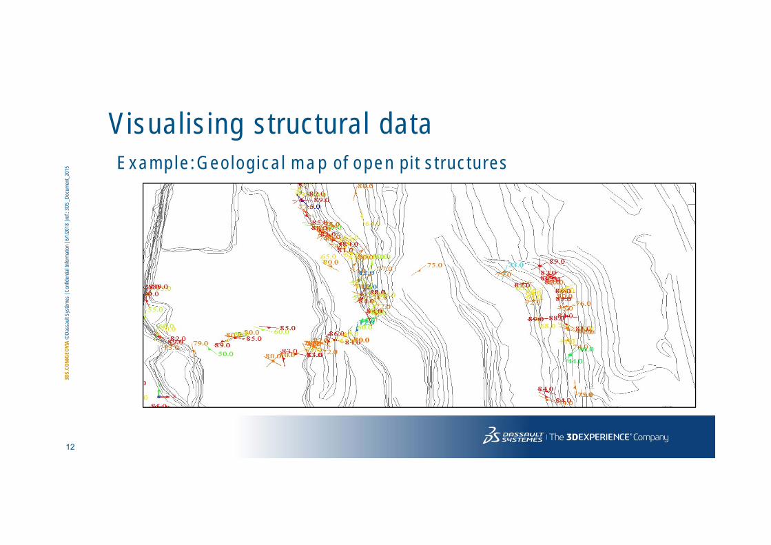
015 E x a m p l e : Geo log ica l m a p of o p e n p i t s t ruc tu res
Visualising structural data

13
3DS.
COM/
GEOV
IA©
Dass
aultS
ystèm
es| C
onfid
entia
l Infor
matio
n | 6
/1/20
18| r
ef.: 3
DS_D
ocum
ent_2
015 E x a m p l e : Su r fa c e g rad ien t v isua l isa t ion
Visualising structural data

14
3DS.
COM/
GEOV
IA©
Dass
aultS
ystèm
es| C
onfid
entia
l Infor
matio
n | 6
/1/20
18| r
ef.: 3
DS_D
ocum
ent_2
015 Example: Foliation visualisation from block model
Visualising structural data

15
3DS.
COM/
GEOV
IA©
Dass
aultS
ystèm
es| C
onfid
entia
l Infor
matio
n | 6
/1/20
18| r
ef.: 3
DS_D
ocum
ent_2
015
General Tools – Create single symbol Create structure symbols manually Select symbol, scale and string number Enter orientation manually, or measure
from three points. Orientation can also be copied from existing symbol.
Enter location or select graphically Graphical selection also allows to select
mid between two points.
16
3DS.
COM/
GEOV
IA©
Dass
aultS
ystèm
es| C
onfid
entia
l Infor
matio
n | 6
/1/20
18| r
ef.: 3
DS_D
ocum
ent_2
015
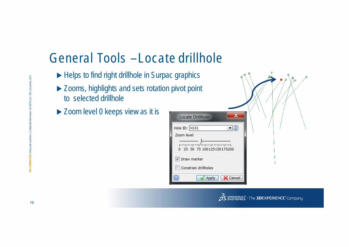
General Tools –Locate drillhole Helps to find right drillhole in Surpac graphics Zooms, highlights and sets rotation pivot point
to selected drillhole Zoom level 0 keeps view as it is

17
3DS.
COM/
GEOV
IA©
Dass
aultS
ystèm
es| C
onfid
entia
l Infor
matio
n | 6
/1/20
18| r
ef.: 3
DS_D
ocum
ent_2
015
General Tools –Triangle info Reports dip/dip direction of selected
triangle, along with all geometrical information
Highlights reported triangle for confidence

18
3DS.
COM/
GEOV
IA©
Dass
aultS
ystèm
es| C
onfid
entia
l Infor
matio
n | 6
/1/20
18| r
ef.: 3
DS_D
ocum
ent_2
015
General Tools – Dip/Dip direction from three points
Reports dip/dip direction of plane defined by three graphically selected points
Tool leaves defined plane to graphics for examination

19
3DS.
COM/
GEOV
IA©
Dass
aultS
ystèm
es| C
onfid
entia
l Infor
matio
n | 6
/1/20
18| r
ef.: 3
DS_D
ocum
ent_2
015
General Tools – Line of intersection Reports dip and azimuth for line of
intersection of two structures Graphically select two structures Dip and azimuth reported in message window Line of intersection created to graphics as
segment Useful tool to evaluate wedge failures in open
pit mines
20
3DS.
COM/
GEOV
IA©
Dass
aultS
ystèm
es| C
onfid
entia
l Infor
matio
n | 6
/1/20
18| r
ef.: 3
DS_D
ocum
ent_2
015
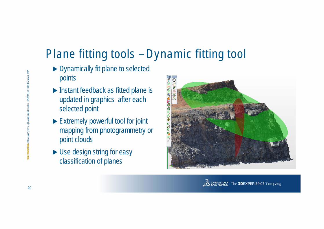
P lane fitting tools – Dynamic fitting tool Dynamically fit plane to selected
points Instant feedback as fitted plane is
updated in graphics after each selected point
Extremely powerful tool for joint mapping from photogrammetry or point clouds
Use design string for easy classification of planes

21
3DS.
COM/
GEOV
IA©
Dass
aultS
ystèm
es| C
onfid
entia
l Infor
matio
n | 6
/1/20
18| r
ef.: 3
DS_D
ocum
ent_2
015
P lane fitt ing tools – Fit plane to segment/string/DTM Fit plane to selected segment, string or DTM/3DM Easily find mean orientation of ore lens solid model

22
3DS.
COM/
GEOV
IA©
Dass
aultS
ystèm
es| C
onfid
entia
l Infor
matio
n | 6
/1/20
18| r
ef.: 3
DS_D
ocum
ent_2
015
Calculate surface gradient grid Calculates gradient grid for DTM surface Preview button to show grid in graphics Export generated data as CSV or string file Can be used in the Visualizer by loading into a database discrete table.

23
3DS.
COM/
GEOV
IA©
Dass
aultS
ystèm
es| C
onfid
entia
l Infor
matio
n | 6
/1/20
18| r
ef.: 3
DS_D
ocum
ent_2
015
Move to plane Projects structure observations into selected planeMany options to define projection plane Show result as symbols, lines (apparent dip) and/or connection lines to original structure location
24
3DS.
COM/
GEOV
IA©
Dass
aultS
ystèm
es| C
onfid
entia
l Infor
matio
n | 6
/1/20
18| r
ef.: 3
DS_D
ocum
ent_2
015
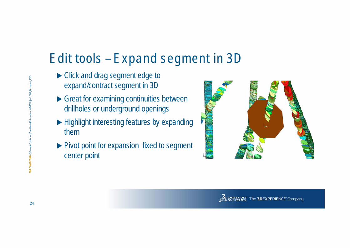
Edi t tools – Expand segment in 3D Click and drag segment edge to
expand/contract segment in 3D Great for examining continuities between
drillholes or underground openings Highlight interesting features by expanding
them Pivot point for expansion fixed to segment
center point

25
3DS.
COM/
GEOV
IA©
Dass
aultS
ystèm
es| C
onfid
entia
l Infor
matio
n | 6
/1/20
18| r
ef.: 3
DS_D
ocum
ent_2
015
Edi t tools – Change dip / Change dip direction Two separate tools to graphically rotate segment dip OR segment direction Click and drag interface, similar to segment expansion First tool changes dip, keeping direction constant Second tool changes direction, keeping dip constantManually adjust segment dip to match other features in graphicsModify “mathematical” plane fit of ore body to better match geological
constraints

26
3DS.
COM/
GEOV
IA©
Dass
aultS
ystèm
es| C
onfid
entia
l Infor
matio
n | 6
/1/20
18| r
ef.: 3
DS_D
ocum
ent_2
015
Edi t tools – Move by middle point Relocate segment by its middle point Graphically select segment and point where middle point of selected segment
should be relocated Tool allows to select mid point of two selected points as destination, making it
possible for example to relocate structure symbol to middle of drillhole interval

27
3DS.
COM/
GEOV
IA©
Dass
aultS
ystèm
es| C
onfid
entia
l Infor
matio
n | 6
/1/20
18| r
ef.: 3
DS_D
ocum
ent_2
015
Stereographic tools –Create projection Digitise polygon around interesting data Stereographic projection is created for
all data inside polygon Excellent tool for finding trends in large
datasets Instantly digitise next selection and
update projection; easy to see changes along drillhole

28
3DS.
COM/
GEOV
IA©
Dass
aultS
ystèm
es| C
onfid
entia
l Infor
matio
n | 6
/1/20
18| r
ef.: 3
DS_D
ocum
ent_2
015
Stereographic tools – Create mean planes Digitise polygon around joint set in
stereographic projection Joint set mean plane is created to
3D graphics Useful tool to interpret fracture zone
orientations from large amounts of logged drillhole data

29
3DS.
COM/
GEOV
IA©
Dass
aultS
ystèm
es| C
onfid
entia
l Infor
matio
n | 6
/1/20
18| r
ef.: 3
DS_D
ocum
ent_2
015
Stereographic tools – Toggle data colours Toggle pole representation between black ticks and source
data colours In example below, foliation data was coloured by rock type.
30
3DS.
COM/
GEOV
IA©
Dass
aultS
ystèm
es| C
onfid
entia
l Infor
matio
n | 6
/1/20
18| r
ef.: 3
DS_D
ocum
ent_2
015
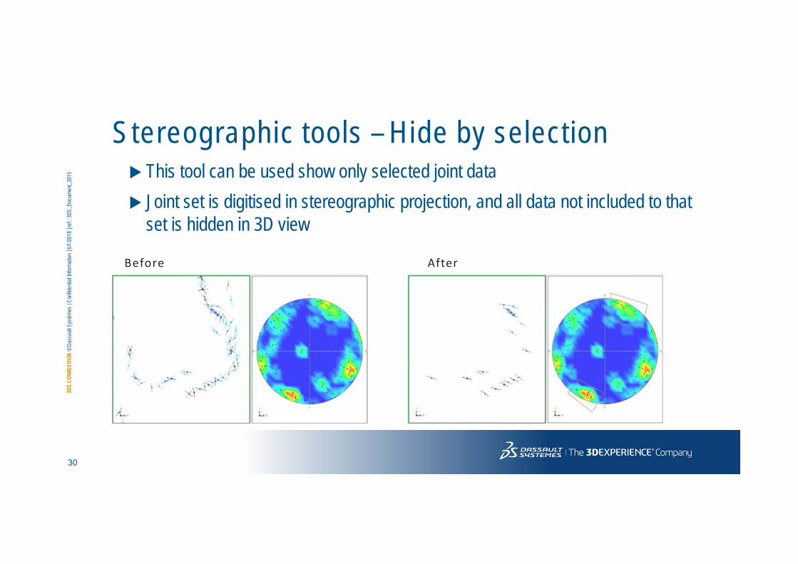
Stereographic tools – Hide by selection This tool can be used show only selected joint data Joint set is digitised in stereographic projection, and all data not included to that
set is hidden in 3D view
Before After

31
3DS.
COM/
GEOV
IA©
Dass
aultS
ystèm
es| C
onfid
entia
l Infor
matio
n | 6
/1/20
18| r
ef.: 3
DS_D
ocum
ent_2
015
Stereographic tools – Export to DIPS Data can be exported directly to
Rocscience DIPS, one of the most widely used stereographic projection tools
Tools to export data within digitised polygon and inside selected solid
More detailed analysis can be performed with DIPS

32
3DS.
COM/
GEOV
IA©
Dass
aultS
ystèm
es| C
onfid
entia
l Infor
matio
n | 6
/1/20
18| r
ef.: 3
DS_D
ocum
ent_2
015 Joint mapping from photogrammetry models OBJ or Point cloud are suitable.
Workf low – planes f rom 3D data

33
3DS.
COM/
GEOV
IA©
Dass
aultS
ystèm
es| C
onfid
entia
l Infor
matio
n | 6
/1/20
18| r
ef.: 3
DS_D
ocum
ent_2
015
Workf low - Wedge fa i lure def in i t ion Evaluation of pit design stability with wedge style failures

34
3DS.
COM/
GEOV
IA©
Dass
aultS
ystèm
es| C
onfid
entia
l Infor
matio
n | 6
/1/20
18| r
ef.: 3
DS_D
ocum
ent_2
015
Surface Geotechnical Samples – Bedding Planes3D Symbols
2D Symbols
Contains British Geological Survey materials © NERCContains OS data © Crown copyright and database right 2017Contains OS data © Crown copyright and database right 2013
Bedding Planes
Stereographic Projection

35
3DS.
COM/
GEOV
IA©
Dass
aultS
ystèm
es| C
onfid
entia
l Infor
matio
n | 6
/1/20
18| r
ef.: 3
DS_D
ocum
ent_2
015
Surface Geotechnical Samples - Faults3D Symbols
Stereographic Projection
Contains British Geological Survey materials © NERCContains OS data © Crown copyright and database right 2017Contains OS data © Crown copyright and database right 2013

36
3DS.
COM/
GEOV
IA©
Dass
aultS
ystèm
es| C
onfid
entia
l Infor
matio
n | 6
/1/20
18| r
ef.: 3
DS_D
ocum
ent_2
015
Downhole Geotechnical Samples
Bedding Planes
Stereographic Projection

37
3DS.
COM/
GEOV
IA©
Dass
aultS
ystèm
es| C
onfid
entia
l Infor
matio
n | 6
/1/20
18| r
ef.: 3
DS_D
ocum
ent_2
015
Mining Scenarios
Pit wall steeper than bedding. Definite problem in need of correction.
38
3DS.
COM/
GEOV
IA©
Dass
aultS
ystèm
es| C
onfid
entia
l Infor
matio
n | 6
/1/20
18| r
ef.: 3
DS_D
ocum
ent_2
015
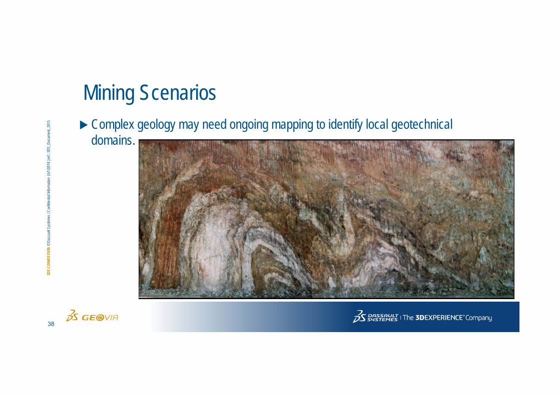
Mining Scenarios Complex geology may need ongoing mapping to identify local geotechnical
domains.

39
3DS.
COM/
GEOV
IA©
Dass
aultS
ystèm
es| C
onfid
entia
l Infor
matio
n | 6
/1/20
18| r
ef.: 3
DS_D
ocum
ent_2
015
Mining Scenarios
Need for safety in manual measurement of structures.

40
3DS.
COM/
GEOV
IA©
Dass
aultS
ystèm
es| C
onfid
entia
l Infor
matio
n | 6
/1/20
18| r
ef.: 3
DS_D
ocum
ent_2
015
Mining Scenarios
Underground stopingpractices; failure to leave a sufficient crown pillar can result in collapse.

41
3DS.
COM/
GEOV
IA©
Dass
aultS
ystèm
es| C
onfid
entia
l Infor
matio
n | 6
/1/20
18| r
ef.: 3
DS_D
ocum
ent_2
015
Mining Scenarios
A reminder that while mining occurs at different scales (using different regulations) around the world, geotechnical concerns remain the same.

42
3DS.
COM/
GEOV
IA©
Dass
aultS
ystèm
es| C
onfid
entia
l Infor
matio
n | 6
/1/20
18| r
ef.: 3
DS_D
ocum
ent_2
015
Mining Scenarios
Time component of stability, life of mine is a factor.

43
3DS.
COM/
GEOV
IA©
Dass
aultS
ystèm
es| C
onfid
entia
l Infor
matio
n | 6
/1/20
18| r
ef.: 3
DS_D
ocum
ent_2
015
Mining Scenarios
Some rock types are just bad news. Highly sheared and weathered rock types need more analysis.
44
3DS.
COM/
GEOV
IA©
Dass
aultS
ystèm
es| C
onfid
entia
l Infor
matio
n | 6
/1/20
18| r
ef.: 3
DS_D
ocum
ent_2
015
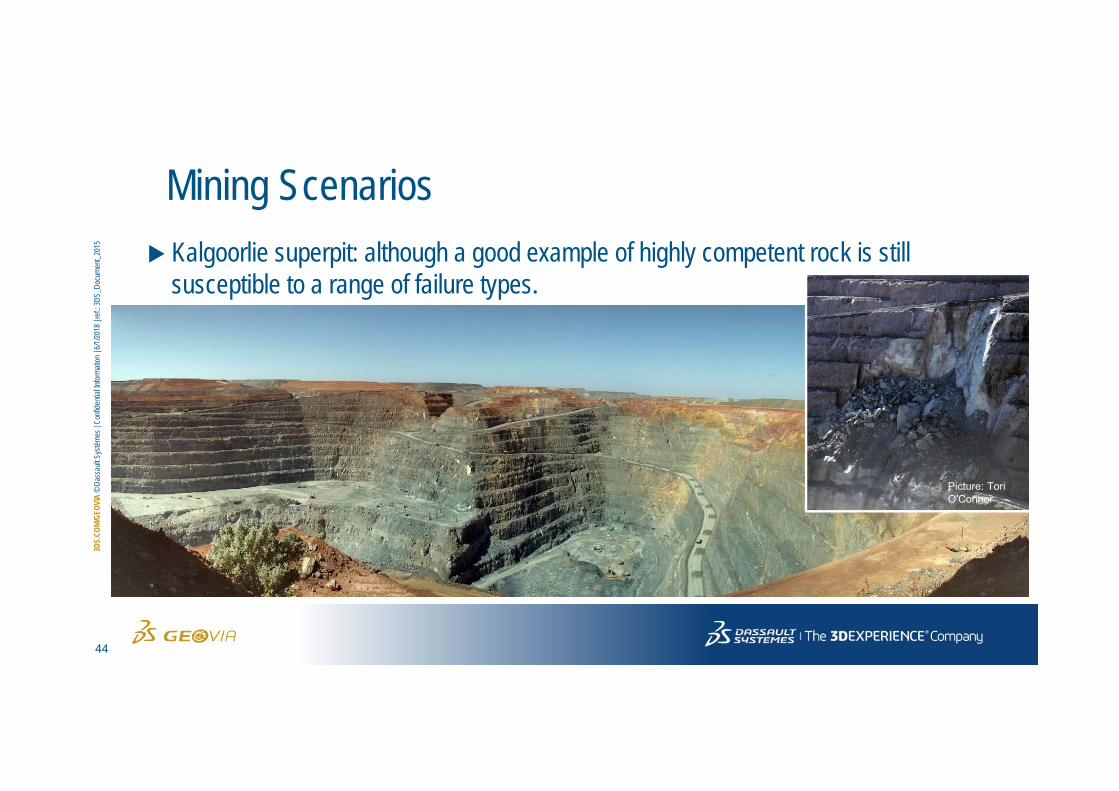
Mining Scenarios Kalgoorlie superpit: although a good example of highly competent rock is still
susceptible to a range of failure types.
Picture: Tori O'Connor

45
3DS.
COM/
GEOV
IA©
Dass
aultS
ystèm
es| C
onfid
entia
l Infor
matio
n | 6
/1/20
18| r
ef.: 3
DS_D
ocum
ent_2
015
Mining Scenarios
Toppling failures occur with steeply dipping joint sets

46
3DS.
COM/
GEOV
IA©
Dass
aultS
ystèm
es| C
onfid
entia
l Infor
matio
n | 6
/1/20
18| r
ef.: 3
DS_D
ocum
ent_2
015
Mining Scenarios
Sheared rocks with smooth surfaces are high risk of failure. Mapping and core measurements will help to identify this.

47
3DS.
COM/
GEOV
IA©
Dass
aultS
ystèm
es| C
onfid
entia
l Infor
matio
n | 6
/1/20
18| r
ef.: 3
DS_D
ocum
ent_2
015
Mining Scenarios
Ramps are particularly critical to keeping the mine productive and safe.

48
3DS.
COM/
3DVI
A©
Dass
aultS
ystèm
es| C
onfid
entia
l Infor
matio
n | 6/
1/201
8| re
f.: 3D
S_Do
cume
nt_20
15