study area characterization work plan post creek … · study area characterization work plan study...
TRANSCRIPT
STUDY AREA CHARACTERIZATION WORK PLAN
Study Area Bounded by Pyrex Street, E. Pulteney Street, Post Creek and Chemung River
Corning, NY NYSDEC Project ID 851046
June 2014
Prepared for:
Corning Incorporated Corning, New York
Prepared by:
WESTON SOLUTIONS, INC. West Chester, Pennsylvania 19380
W.O. No. 02005.056.001.0001
2014_CNY_SCWP_FINAL.docx 6/20/2014
ii
TABLE OF CONTENTS
Section Page 1. INTRODUCTION.......................................................................................................... 1-1
1.1 STUDY AREA CHARACTERIZATION OBJECTIVES .................................. 1-11.2 ORGANIZATION OF THIS DOCUMENT ....................................................... 1-2
2. BACKGROUND ............................................................................................................ 2-12.1 STUDY AREA HISTORY .................................................................................. 2-12.2 AERIAL PHOTOGRAPH REVIEW .................................................................. 2-22.3 CONSTITUENTS OF POTENTIAL CONCERN .............................................. 2-3
3. ENVIRONMENTAL SETTING .................................................................................. 3-13.1 LAND USE .......................................................................................................... 3-13.2 TOPOGRAPHY AND DRAINAGE ................................................................... 3-23.3 GEOLOGY .......................................................................................................... 3-23.4 HYDROGEOLOGY ............................................................................................ 3-23.5 ECOLOGICAL SETTING .................................................................................. 3-3
4. CHARACTERIZATION ACTIVITIES ...................................................................... 4-14.1 AREAS OF INVESTIGATION .......................................................................... 4-14.2 FIELD INVESTIGATION METHODOLOGIES ............................................... 4-3
4.2.1 Written Access Consent ........................................................................ 4-44.2.2 Geophysical Investigation ..................................................................... 4-44.2.3 Subsurface Soil Sampling ..................................................................... 4-54.2.4 Surface and Shallow Soil Sampling ...................................................... 4-74.2.5 Groundwater ......................................................................................... 4-84.2.6 Analytics ............................................................................................... 4-94.2.7 Quality Assurance / Quality Control................................................... 4-104.2.8 Survey Activities ................................................................................. 4-114.2.9 Waste Handling ................................................................................... 4-11
4.3 INVESTIGATION ACTIVITIES ...................................................................... 4-124.3.1 Corning-Painted Post School District Property .................................. 4-124.3.2 Corning Christian Academy Property ................................................. 4-154.3.3 Memorial Stadium and Firehouse Frontage Properties ...................... 4-174.3.4 Residential Area at the Eastern End of Corning Boulevard ............... 4-184.3.5 Residential Area .................................................................................. 4-204.3.6 Flood Control Area ............................................................................. 4-22
5. PROJECT MANAGEMENT ........................................................................................ 5-15.1 SCHEDULE ......................................................................................................... 5-15.2 DOCUMENTATION .......................................................................................... 5-1

TABLE OF CONTENTS (Continued)
Section Page
2014_CNY_SCWP_FINAL.docx 6/20/2014
iii
5.2.1 Field Logs ............................................................................................. 5-15.2.2 Photo Log .............................................................................................. 5-25.2.3 Field Reports ......................................................................................... 5-25.2.4 Data Management ................................................................................. 5-25.2.5 Reporting............................................................................................... 5-3
5.3 HEALTH AND SAFETY PLAN ........................................................................ 5-35.4 STUDY AREA CONTROLS .............................................................................. 5-45.5 COMMUNITY RELATIONS ............................................................................. 5-4
6. REFERENCES ............................................................................................................... 6-1
APPENDIX A – HEALTH AND SAFETY PLAN (HASP)
APPENDIX B – COMMUNITY AIR MONITORING PLAN (CAMP)
APPENDIX C – QUALITY ASSURANCE PROJECT PLAN (QAPP)
APPENDIX D – STANDARD OPERATING PROCEDURES (SOPs)

2014_CNY_SCWP_FINAL.docx 6/20/2014
iv
LIST OF FIGURES
Title
Figure 1-1 Location of the Study Area
Figure 3-1 Zoning
Figure 3-2 Property Classification
Figure 4-1 Areas of Investigation
Figure 4-2 Characterization Activities, Corning-Painted Post School District Property
Figure 4-3 Characterization Activities, Corning Christian Academy Property
Figure 4-4 Characterization Activities, Memorial Stadium Property
Figure 4-5 Characterization Activities, Firehouse Frontage Property
Figure 4-6 Characterization Activities, Residential Area at the Eastern End of Corning Boulevard
Figure 4-7 Characterization Activities, Residential Area
Figure 4-8 Characterization Activities, Houghton Park in Residential Area
Figure 4-9 Flood Control Area
Figure 5-1 Project Schedule
2014_CNY_SCWP_FINAL.docx 6/20/2014
v
LIST OF TABLES
Title
Table 3-1 Properties within the Boundary of the Study Area
Table 4-1 Sample Summary Table
Table 4-2 Analytical Methodologies
Table 4-3 Reporting Limits and Method Detection Limits
2014_CNY_SCWP_FINAL.DOCX 6/20/2014
vi
LIST OF ACRONYMS
ASP Analytical Services Protocol
CAMP Community Air Monitoring Plan
cfs cubic feet per second
COPC constituents of potential concern
DUSR Data Usability Summary Report
EDD electronic data deliverable
EM electromagnetic
FEMA Federal Emergency Management Agency
FOIL Freedom of Information Law
ft amsl feet above mean sea level
ft bgs feet below ground surface
GPR ground penetrating radar
GPS global positioning system
HASP Health and Safety Plan
IDW investigative derived waste
in bgs inches below ground surface
mS/m millisiemens per meter
NWI National Wetland Inventory
NYSDEC New York State Department of Environmental Conservation
PAH polycyclic aromatic hydrocarbon
PC public-conservation zoning
PCB polychlorinated biphenyl
PID Photoionization Detector
PVC polyvinyl chloride
QA Quality Assurance
QAPP Quality Assurance Project Plan
QC Quality Control
R1 low-density residential zoning
RCRA Resource Conservation and Recovery Act
LIST OF ACRONYMS (Continued)
2014_CNY_SCWP_FINAL.docx 6/20/2014
vii
SCO soil cleanup objectives
SOP standard operating procedure
SVOC semi-volatile organic compound
TPH total petroleum hydrocarbon
USACE U.S. Army Corps of Engineers
USGS U.S. Geological Survey
VOC volatile organic compound
WESTON® Weston Solutions, Inc.

2014_CNY_SCWP_FINAL.docx 6/20/2014
1-1
1. INTRODUCTION
The Study Area is located in the City of Corning, New York, and is bounded by Pyrex Street on
the west, E. Pulteney Street on the north, Post Creek on the east and the Chemung River on the
south, as illustrated on Figure 1-1 (Study Area). During construction activities as a part of the
expansion of the Corning-Painted Post East High School located in a portion of the Study Area,
fill materials that the School District described as containing ash, brick, and glass waste was
encountered within the excavation area.
The New York State Department of Environmental Conservation (NYSDEC) approached
Corning Incorporated and presented historic aerial photographs and other information that
indicated there were potential disturbance areas within portions of the Study Area. NYSDEC
requested that Corning Incorporated perform preliminary characterization activities to assess the
nature and extent of fill material that may be encountered within the Study Area.
In preparation for entering into an Order on Consent and Administrative Settlement (Order),
Corning Incorporated has retained Weston Solutions, Inc. (WESTON®) to prepare this Study
Area Characterization Work Plan (Work Plan) for the characterization activities to be conducted
within the Study Area. It is Corning Incorporated’s intention that this Work Plan, upon approval
by NYSDEC, be incorporated into the Order to define the agreed scope of work.
1.1 STUDY AREA CHARACTERIZATION OBJECTIVES
The purpose of the characterization activities is to assess the nature and extent of fill that may be
encountered within the Study Area. In accordance with the Order, Corning Incorporated is
conducting a historic records search and review to establish a history of the Study Area and
identify areas where fill may potentially have been placed. This records search includes a review
of historic aerial photographs to identify areas where historic disturbances may have occurred.
This Work Plan includes a summary of the initial historic records review and a plan for
characterization activities based on the preliminary results of the historic records review. The
characterization activities described herein are designed to assess the nature and extent of fill that

2014_CNY_SCWP_FINAL.docx 6/20/2014
1-2
may be encountered within the Study Area and to develop data necessary for understanding the
current conditions within the Study Area and associated potential exposure pathways.
The specific objectives of the Work Plan are as follows:
1. In areas where historic records indicate potential disturbances:
a. assess the nature and extent of the potential disturbance area, and
b. assess potential exposure pathways, in the event fill material is found.
2. In areas where historic records do not indicate potential disturbances, evaluate the
potential presence of fill material.
1.2 ORGANIZATION OF THIS DOCUMENT
This Work Plan is organized into the following sections:
Section 1 - Introduction. This section contains an introduction to the project and the objectives of the characterization activities.
Section 2 – Background. This section contains a history of the Study Area and a summary of historic records reviewed to date.
Section 3 - Environmental Setting. This section contains a brief description of the Study Area location, land use, topography and drainage, geology, hydrogeology, and ecological setting.
Section 4 – Characterization Activities. This section contains a description of the characterization activities to be conducted, including the locations, types and numbers of samples to be collected, rationale for sample collection, and method of collection for the planned work.
Section 5 – Project Management. This section contains information regarding the scheduling of the characterization field work as well as the reporting schedule. Additionally, this section provides details about project logistics, including project controls, management and public relations.
Section 6 – References.
Tables and figures are provided at the end of each section for ease of review.

2014_CNY_SCWP_FINAL.docx 6/20/2014
1-3
A Health and Safety Plan (HASP), Community Air Monitoring Plan (CAMP), Quality Assurance
Project Plan (QAPP), and Standard Operating Procedures (SOPs) are included in the Appendices
of this Work Plan.

2014_CNY_SCWP_FINAL.docx 6/20/2014
SECTION 1
FIGURES

Study Area
File: Y:\Former_Kent_Phillips_School\MXD\Site_Location.mxd, 6/19/2014 5:25:29 PM, ricksc
Document Name: Site_Location.MXD
Figure 1-1Location of Study Area
Corning NY
²0 2,0001,000
Feet
USGS 7.5 Minute Quadrangle Corning NY, 1971
2014_CNY_SCWP_FINAL.docx 6/20/2014
2-1
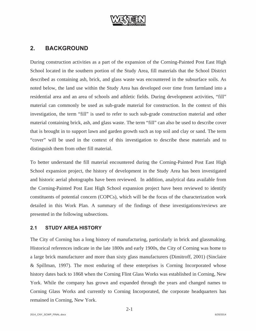
2. BACKGROUND
During construction activities as a part of the expansion of the Corning-Painted Post East High
School located in the southern portion of the Study Area, fill materials that the School District
described as containing ash, brick, and glass waste was encountered in the subsurface soils. As
noted below, the land use within the Study Area has developed over time from farmland into a
residential area and an area of schools and athletic fields. During development activities, “fill”
material can commonly be used as sub-grade material for construction. In the context of this
investigation, the term “fill” is used to refer to such sub-grade construction material and other
material containing brick, ash, and glass waste. The term “fill” can also be used to describe cover
that is brought in to support lawn and garden growth such as top soil and clay or sand. The term
“cover” will be used in the context of this investigation to describe these materials and to
distinguish them from other fill material.
To better understand the fill material encountered during the Corning-Painted Post East High
School expansion project, the history of development in the Study Area has been investigated
and historic aerial photographs have been reviewed. In addition, analytical data available from
the Corning-Painted Post East High School expansion project have been reviewed to identify
constituents of potential concern (COPCs), which will be the focus of the characterization work
detailed in this Work Plan. A summary of the findings of these investigations/reviews are
presented in the following subsections.
2.1 STUDY AREA HISTORY
The City of Corning has a long history of manufacturing, particularly in brick and glassmaking.
Historical references indicate in the late 1800s and early 1900s, the City of Corning was home to
a large brick manufacturer and more than sixty glass manufacturers (Dimitroff, 2001) (Sinclaire
& Spillman, 1997). The most enduring of these enterprises is Corning Incorporated whose
history dates back to 1868 when the Corning Flint Glass Works was established in Corning, New
York. While the company has grown and expanded through the years and changed names to
Corning Glass Works and currently to Corning Incorporated, the corporate headquarters has
remained in Corning, New York.
2014_CNY_SCWP_FINAL.docx 6/20/2014
2-2
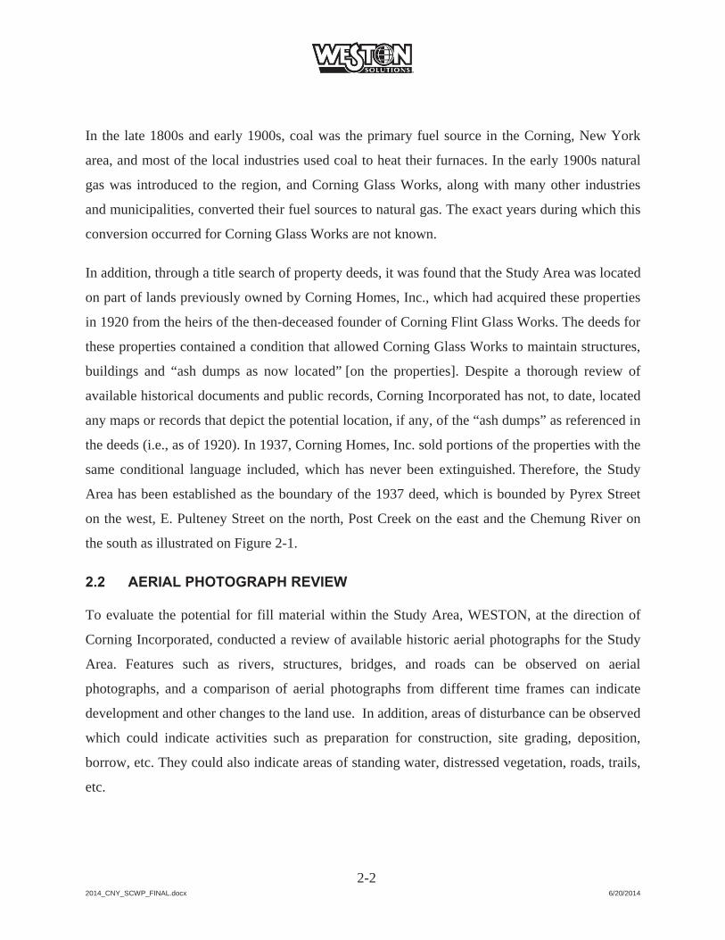
In the late 1800s and early 1900s, coal was the primary fuel source in the Corning, New York
area, and most of the local industries used coal to heat their furnaces. In the early 1900s natural
gas was introduced to the region, and Corning Glass Works, along with many other industries
and municipalities, converted their fuel sources to natural gas. The exact years during which this
conversion occurred for Corning Glass Works are not known.
In addition, through a title search of property deeds, it was found that the Study Area was located
on part of lands previously owned by Corning Homes, Inc., which had acquired these properties
in 1920 from the heirs of the then-deceased founder of Corning Flint Glass Works. The deeds for
these properties contained a condition that allowed Corning Glass Works to maintain structures,
buildings and “ash dumps as now located” [on the properties]. Despite a thorough review of
available historical documents and public records, Corning Incorporated has not, to date, located
any maps or records that depict the potential location, if any, of the “ash dumps” as referenced in
the deeds (i.e., as of 1920). In 1937, Corning Homes, Inc. sold portions of the properties with the
same conditional language included, which has never been extinguished. Therefore, the Study
Area has been established as the boundary of the 1937 deed, which is bounded by Pyrex Street
on the west, E. Pulteney Street on the north, Post Creek on the east and the Chemung River on
the south as illustrated on Figure 2-1.
2.2 AERIAL PHOTOGRAPH REVIEW
To evaluate the potential for fill material within the Study Area, WESTON, at the direction of
Corning Incorporated, conducted a review of available historic aerial photographs for the Study
Area. Features such as rivers, structures, bridges, and roads can be observed on aerial
photographs, and a comparison of aerial photographs from different time frames can indicate
development and other changes to the land use. In addition, areas of disturbance can be observed
which could indicate activities such as preparation for construction, site grading, deposition,
borrow, etc. They could also indicate areas of standing water, distressed vegetation, roads, trails,
etc.

2014_CNY_SCWP_FINAL.docx 6/20/2014
2-3
The following aerial photographs were reviewed for the Study Area:
August 8, 1938 May 8, 1942 April 16, 1952 July 11, 1955 October 8, 1964 March 30, 1968 March/April 2011
In general, the aerial photographs indicate that the development of the residential area north of
Corning Boulevard began prior to 1938 along Pyrex Street and Houghton Circle. It subsequently
expanded in an easterly direction across farmlands until about 1964 when the residential area
was mostly developed. In addition, the 1938 through 1964 aerial photographs appear to indicate
there are potential disturbance areas in limited areas south of Corning Boulevard, and in one
portion of the eastern end of Corning Boulevard, up to the earthen dikes along the Chemung
River and Post Creek. By the 1968 aerial photograph, structures are observed south of Corning
Boulevard in the areas of the Former Kent Phillips School and Corning-Painted Post East High
School.
The potential disturbance areas observed on the 1938 through 1964 aerial photographs will be
specifically investigated as part of the characterization work detailed in this Work Plan. The
Study Area boundary has been established with the 1937 deed because the 1937 deed with the
conditional language predated aerial photography.
2.3 CONSTITUENTS OF POTENTIAL CONCERN
Based on the protocols the Corning-Painted Post School District had established for the
construction activities at the high school, fill material that was encountered was excavated,
segregated and sampled by the School District’s consultant. The School District’s consultant, in
coordination with NYSDEC, based on the analytical results of the stockpiled material, disposed
of approximately three quarters of the excavated material as non-hazardous solid waste and
approximately one quarter of the excavated material as hazardous waste (NYSDEC, 2014).

2014_CNY_SCWP_FINAL.docx 6/20/2014
2-4
A summary of the analytical results for the samples collected of the material excavated during
the 2012 and 2013 expansion of the Corning-Painted Post East High School was supplied by the
School District’s consultant to the NYSDEC. A review of this data summary indicates there were
over 200 samples of the excavated material collected and analyzed for various constituents. The
majority of the constituents were either not detected or were reported at concentrations below the
NYSDEC Residential Soil Cleanup Objectives (SCOs). The primary constituents which
exceeded the Residential SCOs in the excavated materials were lead, cadmium, and arsenic;
therefore, lead, cadmium and arsenic will be used as the COPCs for the characterization
activities described in this Work Plan.

2014_CNY_SCWP_FINAL.docx 6/20/2014
SECTION 2
FIGURES
Cor
ning
Bou
leva
rd
Pyrex Street
E. P
ulte
ney
Stre
et
Argonne Street
Roose
velt S
treet
Houghton Circle
7Ear
then
Dik
eE
arth
en D
ike
Ear
then
Dik
eE
arth
en D
ike
Ear
then
Dik
e
Ath
letic
Fie
lds
Form
erK
ent P
hilli
psS
choo
l
Cor
ning
Chr
istia
nA
cade
my
Cor
ning
-Pai
nted
P
ost H
igh
Sch
ool
Mem
oria
lS
tadi
um
Cor
ning
Fire
Dep
artm
ent
Hou
ghto
nP
ark
Post C
reek
Che
mun
g R
iver
2012
/201
3 H
igh
Sch
ool
Exp
ansi
on A
rea
Figu
re 2
-1St
udy
Area
6/2/
2014
±0
8016
024
0 Met
ers
035
070
0 Feet
NO
TES
: B
ase
Imag
ery:
ES
RI,
Dig
italG
lobe
, Geo
Eye
Map
ping
Ser
vice
, 201
1 C
oord
inat
e S
yste
m: N
AD
198
3 S
tate
Pla
ne
New
Yor
k C
entra
l Fee
t D
atum
: NA
D83
. U
nits
: Fee
t
Doc
umen
t Nam
e: S
tudy
_Are
a_Fe
atur
es.M
XD
Man
gane
se R
esul
tsLe
gend St
udy
Are
a B
ound
ary
Bas
ed o
n19
37 Q
uit C
laim
Dee
d
Stu
dy A
rea
Loca
tion
Stud
y Ar
eaC
orni
ng N
Y
2014_CNY_SCWP_FINAL.docx 6/20/2014
3-1
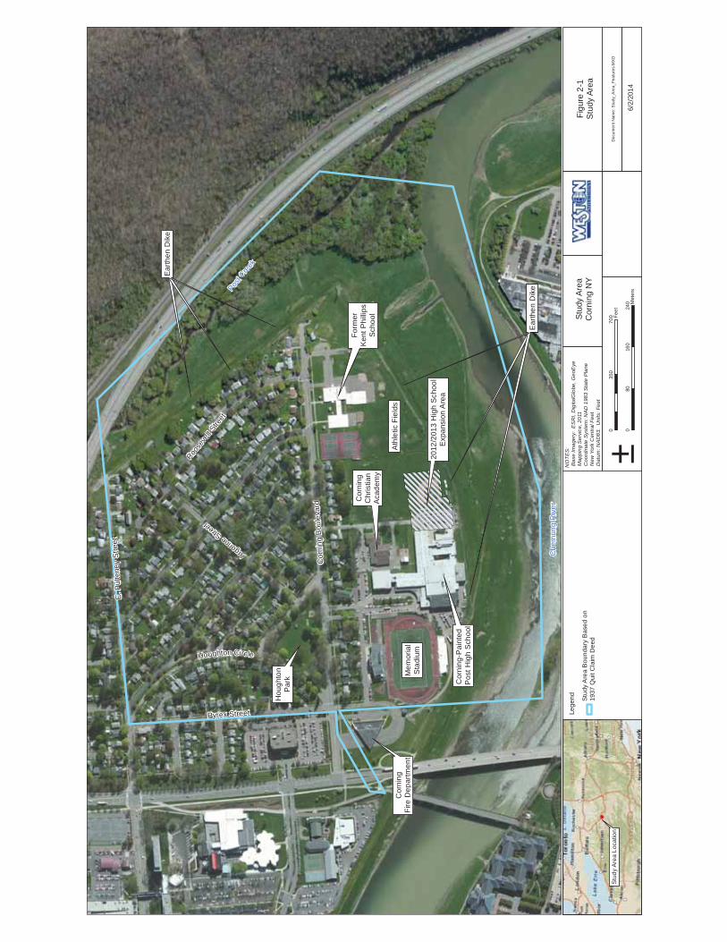
3. ENVIRONMENTAL SETTING
3.1 LAND USE
The Study Area is generally bounded by Pyrex Street on the west, East Pulteney Street on the
north, Post Creek on the east, and the Chemung River on the south. The Study Area consists of
approximately 180 acres of land located on the eastern side of the City of Corning, New York
along the northern bank of the Chemung River, northwest of the confluence with Post Creek (see
Figure 2-1). The Study Area includes the Corning-Painted Post East High School Property; the
Corning Christian Academy Property; the Memorial Stadium Property; the Corning Firehouse
Frontage Property; a residential area consisting of over 200 residences and a public park; and
flood control areas along the Chemung River and Post Creek.
The properties within the Study Area are zoned as either public-conservation (PC) or low-density
residential (R1) by the City of Corning as illustrated on Figure 3-1. The land area zoned PC is
generally concentrated south of Corning Boulevard and in the flood control areas near the
Chemung River and Post Creek. No current industrial/commercial facilities are known to be
located within the Study Area.
The City of Corning property classifications for the Study Area are illustrated on Figure 3-2.
Currently, the portion of the Study Area south of Corning Boulevard and north of the earthen
dike along the Chemung River is primarily used for educational purposes and is owned by the
City of Corning, the Corning-Painted Post School District, and the Corning Christian Academy.
North of the school area is predominately a residential area that consists of 217 individual
properties. Of these properties, 210 are classified as single family residences, three are classified
as multifamily residences or apartments, three are classified as residential-vacant land, and one is
classified as a playground (i.e., Houghton Park). A list of the individual properties that comprise
the Study Area, with the zoning, property classifications, and dates of construction is presented
in Table 3-1.

2014_CNY_SCWP_FINAL.docx 6/20/2014
3-2
3.2 TOPOGRAPHY AND DRAINAGE
The Study Area is relatively flat with a slight gradient to the south and east. The Corning, New
York 1976 U.S. Geological Service (USGS) 7.5-minute topographic quadrangle map indicates
that the Study Area is approximately 929 feet above mean sea level (ft amsl). Within a one mile
radius of the Study Area, the ground surface elevation ranges from 915 ft amsl to 1,459 ft amsl,
with two steep elevation changes, one located to the north and one to the east.
Surface water within the Study Area is collected in storm water drains and generally flows
south/southeast from the Study Area toward the Chemung River. Storm water is believed to be
conveyed to the river through a storm drain(s) located in the southeast corner of the Study Area
(as observed on aerial photographs). Surface water from the confluence of Post Creek and the
Chemung River flows southward to where it ultimately joins the Susquehanna River. Due to the
proximity of the Chemung River and Post Creek, portions of the Study Area, specifically, the
flood control area, are located within both the Federal Emergency Management Agency (FEMA)
100-year and 500-year flood zones (FEMA, 2002).
3.3 GEOLOGY
The Study Area is located in the Chemung River valley, and contains predominately sand and
gravel deposits of glaciofluvial origin and more recent alluvial deposits. In the vicinity of the
Study Area, a low permeability, lacustrine silt and clay layer (approximately 10 feet thick)
appears to be present about 30 feet below ground surface (ft bgs) (Miller, 1982). The river valley
deposits are on the order of 100 feet thick in the vicinity of the Study Area. These river valley
deposits are underlain by low permeability shale/siltstone bedrock (Miller, 1982).
3.4 HYDROGEOLOGY
The saturated portions of the Chemung River valley deposits are recharged principally by
infiltration of precipitation. This valley-filled glacial/alluvial aquifer is generally unconfined
(i.e., the water table forms the upper boundary of the aquifer) and saturated approximately to the
level of nearby rivers (such as the Chemung River) (Olcot, 1995). In the higher topographic
portions of the Study Area, the depth to the water table is expected to be on the order of 20 to 25

2014_CNY_SCWP_FINAL.docx 6/20/2014
3-3
ft bgs; however, groundwater levels may be deeper where supply wells actively extract
groundwater from the valley aquifer. Groundwater in the valley aquifer generally flows toward
and discharges to nearby rivers/creeks; however, groundwater flow directions can be locally
altered by supply well withdrawals from the valley aquifer.
3.5 ECOLOGICAL SETTING
Much of the Study Area is composed of a terrestrial cultural ecological community created and
maintained by human activities and has been modified by human influence to such a degree that
the physical conformation of the substrate and the biological composition of the resident
community is substantially different from the character of the substrate or community as it
existed prior to human influence.
Within the residential area in the north of the Study Area, the ground cover is primarily mowed
lawn with trees. The south-central portion of the Study Area is primarily used for educational
purposes and the ground cover exists in the form of mowed lawn. Further south and to the east, a
large expanse flood control area of mowed lawn habitat is present on the crest and slopes of the
earthen dike.
The Chemung River flows along the southern portion of the Study Area and has a drainage area
of approximately 2,006 square miles. Measured daily flows range from a minimum of 640 cubic
feet per second (cfs) to 20,200 cfs with median and mean flows of 1,820 and 3,620 cfs based on
38 years of records. The Chemung River is designated as Class C water in the New York State
classification system (USGS, 2014).
The much smaller second order Post Creek along the eastern edge of the Study Area also has a
Class C designation in the vicinity of the Study Area. The riparian zone immediately adjacent to
Post Creek is wooded.

2014_CNY_SCWP_FINAL.docx 6/20/2014
SECTION 3
FIGURES

Cor
ning
Bou
leva
rd
Pyrex Street
E. P
ulte
ney
Stre
et
Houghton Circle
Figu
re 3
-1Zo
ning
6/2/
2014
±0
8016
024
0 Met
ers
035
070
0 Feet
NO
TES:
Bas
e Im
ager
y: E
SRI,
Dig
italG
lobe
, Geo
Eye
Map
ping
Ser
vice,
201
1 C
oord
inat
e Sy
stem
: NAD
198
3 St
ate
Plan
e N
ew Y
ork
Cen
tral F
eet
Dat
um: N
AD83
. Un
its: F
eet
Doc
umen
t Nam
e: Z
onin
g.M
XD
Man
gane
se R
esul
tsLe
gend St
udy
Area
Bou
ndar
y
Zoni
ng Publ
ic-C
onse
rvat
ion
R1
- Low
Den
sity
Stu
dy A
rea
Loca
tion
Stud
y Ar
eaC
orni
ng N
Y

Cor
ning
Bou
leva
rd
Pyrex Street
E. P
ulte
ney
Stre
et
Houghton Circle
Figu
re 3
-2Pr
oper
ty C
lass
ifica
tion
6/2/
2014
±0
8016
024
0 Met
ers
035
070
0 Feet
NO
TES:
Bas
e Im
ager
y: E
SRI,
Dig
italG
lobe
, Geo
Eye
Map
ping
Ser
vice,
201
1 C
oord
inat
e Sy
stem
: NAD
198
3 St
ate
Plan
e N
ew Y
ork
Cen
tral F
eet
Dat
um: N
AD83
. Un
its: F
eet
Doc
umen
t Nam
e: P
rope
rty_C
lass
ifica
tion.
MX
D
Man
gane
se R
esul
tsLe
gend St
udy
Are
a B
ound
ary
Prop
ety
Cla
ssifi
catio
n21
0 - S
ingl
e Fa
mily
Res
iden
ce22
0 - M
ulti
Fam
ily R
esid
ence
311
- Res
iden
tial -
Vac
ant L
and
411
- Apa
rtmen
t
591
- Pla
ygro
und
592
- Ath
letic
Fie
ld61
2 - S
choo
l61
5 - E
duca
tiona
l Fac
ility
622
- Fire
/Pol
ice
821
- Flo
od C
ontro
l
Roa
d
Stu
dy A
rea
Loca
tion
Stud
y Ar
eaC
orni
ng N
Y

2014_CNY_SCWP_FINAL.docx 6/20/2014
SECTION 3 TABLES
Table 3-1Properties within the Boundaries of the Study Area
Corning, New York
Parcel ID Address Zoning Property Classification Year Built
318.05-03-029.000 67 Wilson St R1 Single Family Residence 1952318.05-03-032.000 236 E Pulteney St R1 Single Family Residence 1950318.05-03-033.000 240 E Pulteney St R1 Single Family Residence 1973318.05-03-028.000 65 Wilson St R1 Single Family Residence 1974318.05-03-030.000 232 E Pulteney St R1 Single Family Residence 1950318.05-03-031.000 234 E Pulteney St R1 Single Family Residence 1945318.05-01-006.000 61 Pershing St R1 Single Family Residence 1956318.05-01-004.000 4 Belleau St R1 Single Family Residence 1960318.05-01-005.000 65 Pershing St R1 Single Family Residence 1926318.05-01-010.000 47 Pershing St R1 Single Family Residence 1950318.05-01-011.000 45 Pershing St R1 Single Family Residence 1973317.08-01-039.000 Flood Control Area PC Flood Control Area ---318.06-01-001.000 Flood Control Area PC Flood Control Area ---318.05-01-003.000 6 Belleau St R1 Single Family Residence 1928318.05-01-009.000 49 Pershing St R1 Single Family Residence 1926318.05-01-013.000 33 Pershing St R1 Single Family Residence 1927318.05-01-014.000 29 Pershing St R1 Single Family Residence 1955318.05-01-018.000 29 Pershing St R1 Single Family Residence ---318.05-01-020.000 33 Sims Ave R1 Single Family Residence 1999318.05-01-021.000 31 Sims Ave R1 Single Family Residence 1943318.05-01-022.000 27 Sims Ave R1 Single Family Residence 1930318.05-01-024.000 19 Sims Ave R1 Single Family Residence 1943318.05-01-025.000 17 Sims Ave R1 Single Family Residence 1940318.05-01-015.000 25 Pershing St R1 Single Family Residence 1926318.05-01-017.000 75 Corning Blvd R1 Single Family Residence 1940318.05-01-023.000 21 Sims Ave R1 Single Family Residence 1922318.05-01-007.000 57 Pershing St R1 Single Family Residence 1928318.05-01-008.000 53 Pershing St R1 Single Family Residence 1972318.05-01-012.000 35 Pershing St R1 Single Family Residence 1946318.05-01-001.000 Pershing St (Memorial Stone) R1 Residential - Vacant ---318.05-01-019.000 65 Corning Blvd R1 Single Family Residence 1939318.05-01-035.000 18 Corning Blvd R1 Single Family Residence 1930318.05-01-045.000 74 Corning Blvd R1 Single Family Residence 1928318.05-01-047.000 82 Corning Blvd R1 Single Family Residence 1930318.05-01-048.000 84 Corning Blvd R1 Single Family Residence 1929318.05-01-026.000 15 Sims Ave R1 Single Family Residence 1956318.05-01-027.000 11 Sims Ave R1 Single Family Residence 1940318.05-01-028.000 42 Houghton Cir R1 Single Family Residence 1940318.05-01-029.000 40 Houghton Cir R1 Single Family Residence 1910318.05-01-039.000 26 Corning Blvd R1 Single Family Residence 1974318.05-01-044.000 66 Corning Blvd R1 Single Family Residence 1935318.05-01-050.000 100 Corning Blvd R1 Single Family Residence 1945318.05-01-068.000 202 Cantigny St (Stadium) PC Athletic Field ---318.05-01-002.000 69 Pershing St R1 Single Family Residence 1942318.05-01-016.000 21 Pershing St R1 Single Family Residence 1930318.05-01-031.000 Houghton Park R1 Playground ---318.05-01-032.000 6 Corning Blvd R1 Single Family Residence 1973318.05-01-036.000 20 Corning Blvd R1 Single Family Residence 1940318.05-01-041.000 50 Corning Blvd R1 Apartment ---318.05-01-043.000 58 Corning Blvd R1 Single Family Residence 1940318.05-01-046.000 78 Corning Blvd R1 Single Family Residence 1942318.05-01-049.000 94 Corning Blvd R1 Single Family Residence 1952
Table_3-1.xlsx Page 1 of 5 6/20/2014
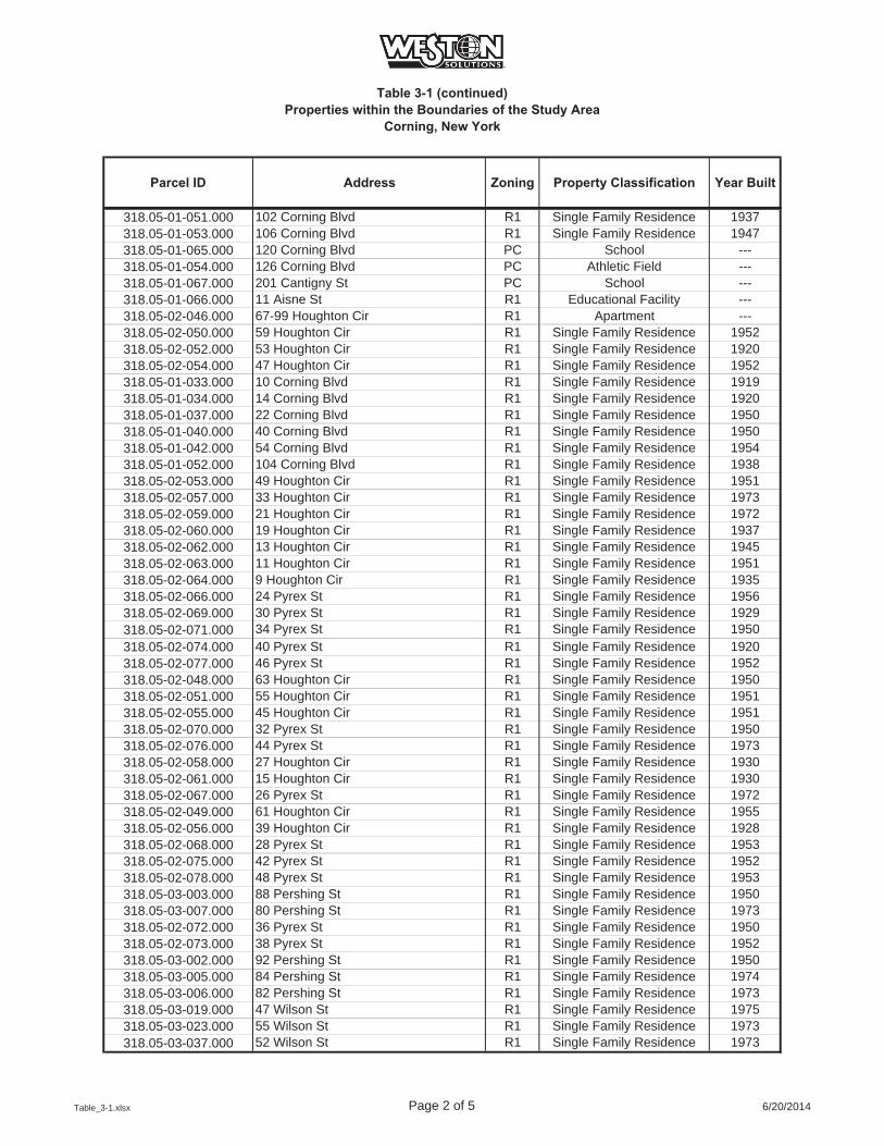
Table 3-1 (continued)Properties within the Boundaries of the Study Area
Corning, New York
Parcel ID Address Zoning Property Classification Year Built
318.05-01-051.000 102 Corning Blvd R1 Single Family Residence 1937318.05-01-053.000 106 Corning Blvd R1 Single Family Residence 1947318.05-01-065.000 120 Corning Blvd PC School ---318.05-01-054.000 126 Corning Blvd PC Athletic Field ---318.05-01-067.000 201 Cantigny St PC School ---318.05-01-066.000 11 Aisne St R1 Educational Facility ---318.05-02-046.000 67-99 Houghton Cir R1 Apartment ---318.05-02-050.000 59 Houghton Cir R1 Single Family Residence 1952318.05-02-052.000 53 Houghton Cir R1 Single Family Residence 1920318.05-02-054.000 47 Houghton Cir R1 Single Family Residence 1952318.05-01-033.000 10 Corning Blvd R1 Single Family Residence 1919318.05-01-034.000 14 Corning Blvd R1 Single Family Residence 1920318.05-01-037.000 22 Corning Blvd R1 Single Family Residence 1950318.05-01-040.000 40 Corning Blvd R1 Single Family Residence 1950318.05-01-042.000 54 Corning Blvd R1 Single Family Residence 1954318.05-01-052.000 104 Corning Blvd R1 Single Family Residence 1938318.05-02-053.000 49 Houghton Cir R1 Single Family Residence 1951318.05-02-057.000 33 Houghton Cir R1 Single Family Residence 1973318.05-02-059.000 21 Houghton Cir R1 Single Family Residence 1972318.05-02-060.000 19 Houghton Cir R1 Single Family Residence 1937318.05-02-062.000 13 Houghton Cir R1 Single Family Residence 1945318.05-02-063.000 11 Houghton Cir R1 Single Family Residence 1951318.05-02-064.000 9 Houghton Cir R1 Single Family Residence 1935318.05-02-066.000 24 Pyrex St R1 Single Family Residence 1956318.05-02-069.000 30 Pyrex St R1 Single Family Residence 1929318.05-02-071.000 34 Pyrex St R1 Single Family Residence 1950318.05-02-074.000 40 Pyrex St R1 Single Family Residence 1920318.05-02-077.000 46 Pyrex St R1 Single Family Residence 1952318.05-02-048.000 63 Houghton Cir R1 Single Family Residence 1950318.05-02-051.000 55 Houghton Cir R1 Single Family Residence 1951318.05-02-055.000 45 Houghton Cir R1 Single Family Residence 1951318.05-02-070.000 32 Pyrex St R1 Single Family Residence 1950318.05-02-076.000 44 Pyrex St R1 Single Family Residence 1973318.05-02-058.000 27 Houghton Cir R1 Single Family Residence 1930318.05-02-061.000 15 Houghton Cir R1 Single Family Residence 1930318.05-02-067.000 26 Pyrex St R1 Single Family Residence 1972318.05-02-049.000 61 Houghton Cir R1 Single Family Residence 1955318.05-02-056.000 39 Houghton Cir R1 Single Family Residence 1928318.05-02-068.000 28 Pyrex St R1 Single Family Residence 1953318.05-02-075.000 42 Pyrex St R1 Single Family Residence 1952318.05-02-078.000 48 Pyrex St R1 Single Family Residence 1953318.05-03-003.000 88 Pershing St R1 Single Family Residence 1950318.05-03-007.000 80 Pershing St R1 Single Family Residence 1973318.05-02-072.000 36 Pyrex St R1 Single Family Residence 1950318.05-02-073.000 38 Pyrex St R1 Single Family Residence 1952318.05-03-002.000 92 Pershing St R1 Single Family Residence 1950318.05-03-005.000 84 Pershing St R1 Single Family Residence 1974318.05-03-006.000 82 Pershing St R1 Single Family Residence 1973318.05-03-019.000 47 Wilson St R1 Single Family Residence 1975318.05-03-023.000 55 Wilson St R1 Single Family Residence 1973318.05-03-037.000 52 Wilson St R1 Single Family Residence 1973
Table_3-1.xlsx Page 2 of 5 6/20/2014

Table 3-1 (continued)Properties within the Boundaries of the Study Area
Corning, New York
Parcel ID Address Zoning Property Classification Year Built
318.05-03-038.000 50 Wilson St R1 Single Family Residence 1974318.05-03-040.000 46 Wilson St R1 Single Family Residence ---318.05-03-042.000 42 Wilson St R1 Single Family Residence 1950318.05-03-045.000 111 Argonne St R1 Single Family Residence 1957318.05-03-046.000 6 Jackson Cir R1 Single Family Residence 1940318.05-03-049.000 12 Jackson Cir R1 Single Family Residence 1948318.05-03-054.000 262 E Pulteney St R1 Single Family Residence 1958318.05-03-055.000 260 E Pulteney St R1 Single Family Residence 1927318.05-03-008.000 66 Pershing St R1 Single Family Residence 1938318.05-03-010.000 62 Pershing St R1 Single Family Residence 1948318.05-03-014.000 50 Pershing St R1 Single Family Residence 1975318.05-03-022.000 53 Wilson St R1 Single Family Residence 1973318.05-03-056.000 264 E Pulteney St R1 Single Family Residence 1960318.05-03-058.000 268 E Pulteney St R1 Single Family Residence 1960318.05-04-002.000 34 Pershing St R1 Single Family Residence 1940318.05-04-003.000 30 Pershing St R1 Single Family Residence 1925318.05-04-006.000 18 Pershing St R1 Single Family Residence 1928318.05-03-052.000 252 E Pulteney St R1 Single Family Residence 1973318.05-03-053.000 258 E Pulteney St R1 Single Family Residence 1927318.05-03-060.000 121 Argonne St R1 Single Family Residence 1973318.05-03-063.000 115 Argonne St R1 Single Family Residence 1956318.05-03-009.000 64 Pershing St R1 Single Family Residence 1973318.05-03-011.000 60 Pershing St R1 Single Family Residence 1943318.05-03-013.000 54 Pershing St R1 Single Family Residence 1945318.05-03-015.000 42 Pershing St R1 Single Family Residence 1925318.05-03-020.000 49 Wilson St R1 Single Family Residence 1948318.05-03-026.000 61 Wilson St R1 Single Family Residence 1974318.05-03-036.000 54 Wilson St R1 Single Family Residence 1973318.05-03-043.000 34 Wilson St R1 Single Family Residence 1950318.05-03-001.000 94 Pershing St R1 Single Family Residence 1946318.05-03-004.000 86 Pershing St R1 Single Family Residence 1950318.05-03-012.000 58 Pershing St R1 Single Family Residence 1940318.05-03-016.000 99 Argonne St R1 Single Family Residence 1973318.05-03-018.000 45 Wilson St R1 Single Family Residence 1975318.05-03-025.000 59 Wilson St R1 Single Family Residence 1974318.05-03-034.000 244 E Pulteney St R1 Single Family Residence 1952318.05-03-035.000 56 Wilson St R1 Single Family Residence 1973318.05-03-064.000 113 Argonne St R1 Single Family Residence 1960318.05-03-065.000 7 Jackson Cir R1 Single Family Residence 1946318.05-03-066.000 17 Jackson Cir R1 Residential - Vacant ---318.05-04-013.000 7 Wilson St R1 Single Family Residence 1948318.05-04-017.000 15 Wilson St R1 Single Family Residence 1947318.05-04-007.000 14 Pershing St R1 Single Family Residence 1937318.05-04-009.000 8 Pershing St R1 Single Family Residence 1969318.05-04-014.000 9 Wilson St R1 Single Family Residence 1947318.05-04-015.000 11 Wilson St R1 Single Family Residence 1948318.05-04-019.000 19 Wilson St R1 Single Family Residence 1947318.05-04-022.000 25 Wilson St R1 Single Family Residence 1947318.05-04-023.000 27 Wilson St R1 Single Family Residence 1947318.05-04-029.000 28 Wilson St R1 Single Family Residence 1947318.05-04-032.000 22 Wilson St R1 Single Family Residence 1951
Table_3-1.xlsx Page 3 of 5 6/20/2014
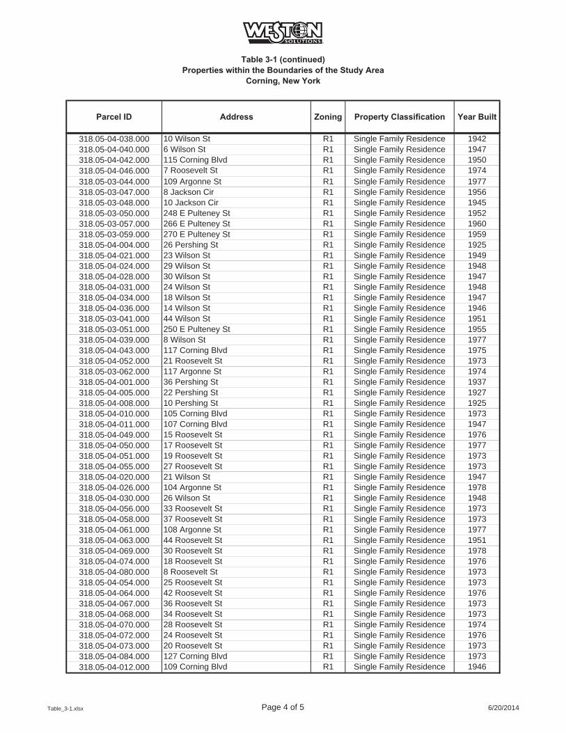
Table 3-1 (continued)Properties within the Boundaries of the Study Area
Corning, New York
Parcel ID Address Zoning Property Classification Year Built
318.05-04-038.000 10 Wilson St R1 Single Family Residence 1942318.05-04-040.000 6 Wilson St R1 Single Family Residence 1947318.05-04-042.000 115 Corning Blvd R1 Single Family Residence 1950318.05-04-046.000 7 Roosevelt St R1 Single Family Residence 1974318.05-03-044.000 109 Argonne St R1 Single Family Residence 1977318.05-03-047.000 8 Jackson Cir R1 Single Family Residence 1956318.05-03-048.000 10 Jackson Cir R1 Single Family Residence 1945318.05-03-050.000 248 E Pulteney St R1 Single Family Residence 1952318.05-03-057.000 266 E Pulteney St R1 Single Family Residence 1960318.05-03-059.000 270 E Pulteney St R1 Single Family Residence 1959318.05-04-004.000 26 Pershing St R1 Single Family Residence 1925318.05-04-021.000 23 Wilson St R1 Single Family Residence 1949318.05-04-024.000 29 Wilson St R1 Single Family Residence 1948318.05-04-028.000 30 Wilson St R1 Single Family Residence 1947318.05-04-031.000 24 Wilson St R1 Single Family Residence 1948318.05-04-034.000 18 Wilson St R1 Single Family Residence 1947318.05-04-036.000 14 Wilson St R1 Single Family Residence 1946318.05-03-041.000 44 Wilson St R1 Single Family Residence 1951318.05-03-051.000 250 E Pulteney St R1 Single Family Residence 1955318.05-04-039.000 8 Wilson St R1 Single Family Residence 1977318.05-04-043.000 117 Corning Blvd R1 Single Family Residence 1975318.05-04-052.000 21 Roosevelt St R1 Single Family Residence 1973318.05-03-062.000 117 Argonne St R1 Single Family Residence 1974318.05-04-001.000 36 Pershing St R1 Single Family Residence 1937318.05-04-005.000 22 Pershing St R1 Single Family Residence 1927318.05-04-008.000 10 Pershing St R1 Single Family Residence 1925318.05-04-010.000 105 Corning Blvd R1 Single Family Residence 1973318.05-04-011.000 107 Corning Blvd R1 Single Family Residence 1947318.05-04-049.000 15 Roosevelt St R1 Single Family Residence 1976318.05-04-050.000 17 Roosevelt St R1 Single Family Residence 1977318.05-04-051.000 19 Roosevelt St R1 Single Family Residence 1973318.05-04-055.000 27 Roosevelt St R1 Single Family Residence 1973318.05-04-020.000 21 Wilson St R1 Single Family Residence 1947318.05-04-026.000 104 Argonne St R1 Single Family Residence 1978318.05-04-030.000 26 Wilson St R1 Single Family Residence 1948318.05-04-056.000 33 Roosevelt St R1 Single Family Residence 1973318.05-04-058.000 37 Roosevelt St R1 Single Family Residence 1973318.05-04-061.000 108 Argonne St R1 Single Family Residence 1977318.05-04-063.000 44 Roosevelt St R1 Single Family Residence 1951318.05-04-069.000 30 Roosevelt St R1 Single Family Residence 1978318.05-04-074.000 18 Roosevelt St R1 Single Family Residence 1976318.05-04-080.000 8 Roosevelt St R1 Single Family Residence 1973318.05-04-054.000 25 Roosevelt St R1 Single Family Residence 1973318.05-04-064.000 42 Roosevelt St R1 Single Family Residence 1976318.05-04-067.000 36 Roosevelt St R1 Single Family Residence 1973318.05-04-068.000 34 Roosevelt St R1 Single Family Residence 1973318.05-04-070.000 28 Roosevelt St R1 Single Family Residence 1974318.05-04-072.000 24 Roosevelt St R1 Single Family Residence 1976318.05-04-073.000 20 Roosevelt St R1 Single Family Residence 1973318.05-04-084.000 127 Corning Blvd R1 Single Family Residence 1973318.05-04-012.000 109 Corning Blvd R1 Single Family Residence 1946
Table_3-1.xlsx Page 4 of 5 6/20/2014
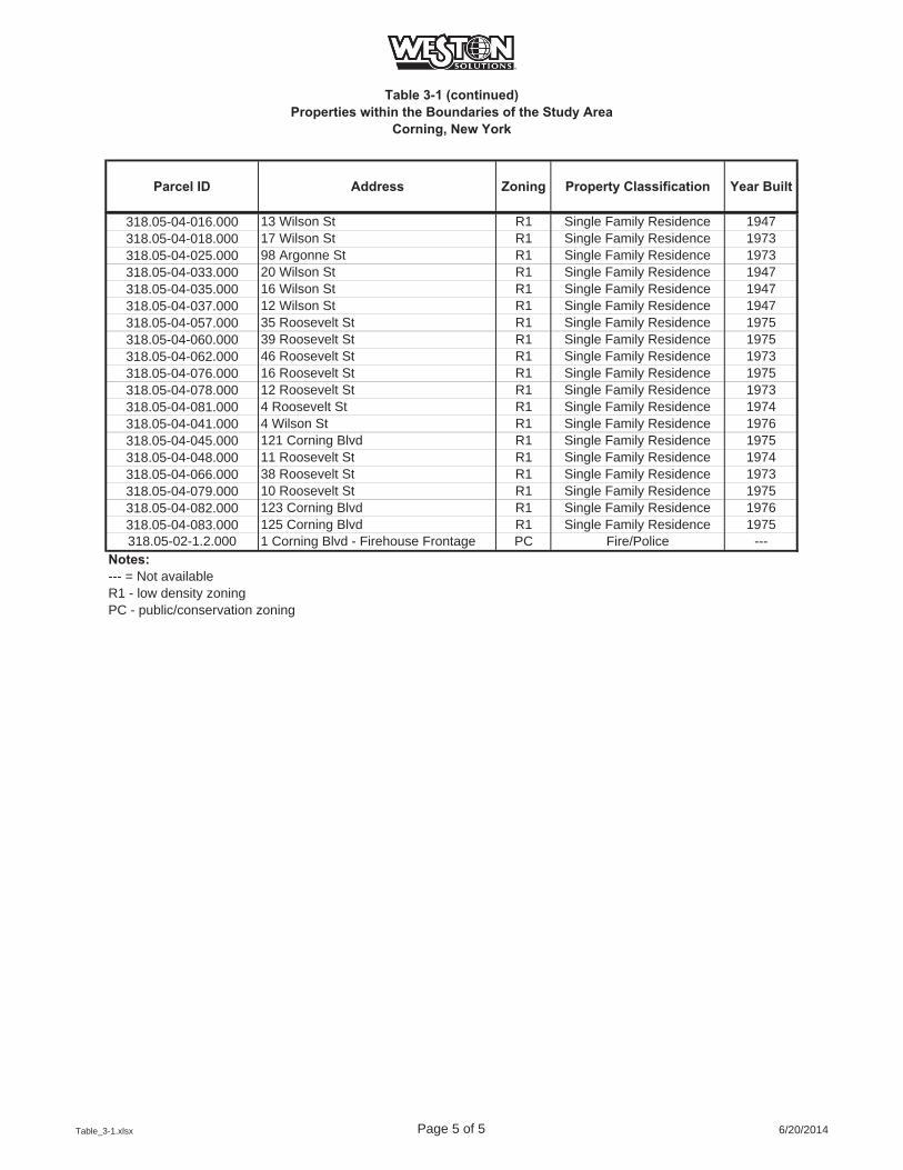
Table 3-1 (continued)Properties within the Boundaries of the Study Area
Corning, New York
Parcel ID Address Zoning Property Classification Year Built
318.05-04-016.000 13 Wilson St R1 Single Family Residence 1947318.05-04-018.000 17 Wilson St R1 Single Family Residence 1973318.05-04-025.000 98 Argonne St R1 Single Family Residence 1973318.05-04-033.000 20 Wilson St R1 Single Family Residence 1947318.05-04-035.000 16 Wilson St R1 Single Family Residence 1947318.05-04-037.000 12 Wilson St R1 Single Family Residence 1947318.05-04-057.000 35 Roosevelt St R1 Single Family Residence 1975318.05-04-060.000 39 Roosevelt St R1 Single Family Residence 1975318.05-04-062.000 46 Roosevelt St R1 Single Family Residence 1973318.05-04-076.000 16 Roosevelt St R1 Single Family Residence 1975318.05-04-078.000 12 Roosevelt St R1 Single Family Residence 1973318.05-04-081.000 4 Roosevelt St R1 Single Family Residence 1974318.05-04-041.000 4 Wilson St R1 Single Family Residence 1976318.05-04-045.000 121 Corning Blvd R1 Single Family Residence 1975318.05-04-048.000 11 Roosevelt St R1 Single Family Residence 1974318.05-04-066.000 38 Roosevelt St R1 Single Family Residence 1973318.05-04-079.000 10 Roosevelt St R1 Single Family Residence 1975318.05-04-082.000 123 Corning Blvd R1 Single Family Residence 1976318.05-04-083.000 125 Corning Blvd R1 Single Family Residence 1975318.05-02-1.2.000 1 Corning Blvd - Firehouse Frontage PC Fire/Police ---
Notes:--- = Not availableR1 - low density zoningPC - public/conservation zoning
Table_3-1.xlsx Page 5 of 5 6/20/2014
2014_CNY_SCWP_FINAL.docx 6/20/2014
4-1
4. CHARACTERIZATION ACTIVITIES
4.1 AREAS OF INVESTIGATION
The proposed characterization activities across the Study Area are focused primarily based upon
current use and historic knowledge. For this Work Plan the Study Area has been divided into
seven subareas, as follows: 1) Corning-Painted Post School District Property, 2) Corning
Christian Academy Property, 3) Memorial Stadium Property, 4) Firehouse Frontage Property, 5)
Residential Area at the Eastern End of Corning Boulevard, 6) Residential Area, and 7) Flood
Control Area. The approximate limits of the subareas within the Study Area are identified on
Figure 4-1.
1) Corning-Painted Post School District Property
The Corning-Painted Post School District Property consists of three parcels of contiguous land
covering approximately 25 acres. All three parcels are owned by the Corning-Painted Post
School District. According to City of Corning zoning information, all three parcels are zoned PC
and classified as a School and Athletic Fields (see Figures 3-1 and 3-2).
Potential disturbance areas were identified in the central and eastern portions of the Corning-
Painted Post School District Property during the review of historic aerial photographs.
Construction activities associated with the expansion of the Corning-Painted Post East High
School reportedly included excavation and removal of fill material and capping portions of the
property with cover soil. The horizontal and vertical limits of fill material in this area were not
determined during the school construction project.
2) Corning Christian Academy Property
The Corning Christian Academy Property is located on an approximate 2.6 acre parcel
immediately north and east of the Corning-Painted Post East High School. This property is
owned by the Corning Christian Academy, Inc. According to the City of Corning, the parcel is
zoned PC, and classified as an Educational Facility (see Figures 3-1 and 3-2).

2014_CNY_SCWP_FINAL.docx 6/20/2014
4-2
3) and 4) Memorial Stadium and Firehouse Frontage Properties
The Memorial Stadium property and a portion of the Firehouse Frontage property that lies within
the 1937 deed footprint are located on two parcels covering approximately 7.9 acres in total. This
land is owned by the City of Corning. According to the City of Corning, both parcels are zoned
PC, and are classified as Athletic Field (Memorial Stadium Property) and Fire/Police (Firehouse
Frontage Property), respectively (see Figures 3-1 and 3-2).
5) Residential Area at the Eastern End of Corning Boulevard
A small portion of the residential area located at the eastern end of Corning Boulevard has been
defined as one of the areas of investigation. A potential disturbance area was identified in this
area during the review of historic aerial photographs. A portion of this potential disturbance area
was located north of Corning Boulevard, and a portion was located south of Corning Boulevard.
The area south of Corning Boulevard is contained within the Corning-Painted Post School
District Property area discussed above. The “Residential Area at the Eastern End of Corning
Boulevard” refers to the portion of the potential disturbance area north of Corning Boulevard.
The potential disturbance area north of Corning Boulevard covers portions of five parcels which
are all zoned R1 by the City of Corning and classified as Single Family Residences (see Figures
3-1 and 3-2). For purposes of the characterization activities, the Residential Area at the Eastern
End of Corning Boulevard includes the entire footprint of each of the affected five parcels, which
encompass a total of approximately 2.5 acres.
6) Residential Area
The Residential Area of the Study Area shown on Figure 4-1 contains 212 individual parcels,
totaling approximately 69 acres. The Residential Area consists of:
An approximately 62-acre area north of Corning Boulevard. This area contains 191 parcels, and is bounded to the north by East Pulteney Street, to the south by Corning Boulevard, to the west by Pyrex Street, and to the east by the flood control dike along Post Creek. This area also includes one public park (Houghton Park).
2014_CNY_SCWP_FINAL.docx 6/20/2014
4-3
An approximately 7-acre area, consisting of 21 parcels, bounded to the north by Corning Boulevard, to the east by the tennis courts associated with the Corning-Painted Post East High School, to the west by Craumer Drive and to the south by Jacoby Boulevard and the Corning-Painted Post East High School.
All of the parcels within the defined Residential Area are zoned R1 by the City of Corning; 205
are classified as Single Family Residence, one is classified as a Multi Family Residence, three
are classified as Residential-Vacant Land, two are classified as Apartment and one as Playground
(i.e., Houghton Park) (see Figures 3-1 and 3-2).
7) Flood Control Area
The Flood Control Area is confined to the areas along the eastern and southern boundaries of the
Study Area. The Flood Control Area is the area between the Residential Area and the banks of
Post Creek as well as the area between the Corning-Painted Post School District Property and the
Chemung River including the earthen dikes. The Flood Control Area property is owned by the
City of Corning and it covers two parcels consisting of approximately 73 acres. The Flood
Control Area is zoned PC and classified as Flood Control (see Figures 3-1 and 3-2).
4.2 FIELD INVESTIGATION METHODOLOGIES
The subsections below describe the field investigation methodologies to be utilized for the
characterization activities at the Study Area. The proposed methodologies may be adjusted in the
field based upon a variety of factors including field conditions, selected subcontractor equipment
and other necessary adjustments. The NYSDEC will be notified of any proposed significant
changes or deviations from the approved Work Plan (including any proposed use of investigation
methodologies other than those described below) and NYSDEC approval will be obtained prior
to implementation. Minor field adjustments or the addition of sampling locations that do not
affect the project objectives will be discussed verbally with the NYSDEC project manager,
confirmed by subsequent email and/or documented in the field notes, and ultimately noted in the
investigation summary report.
Planned soil characterization activities include a combination of soil boring and surface soil
sampling. Characterization activities may also include the installation of shallow groundwater
2014_CNY_SCWP_FINAL.docx 6/20/2014
4-4
monitoring wells. The number of sampling locations, specific to each designated subarea, is
described in the subsequent subsections. Final locations will be established based on utility
clearance, accessibility, and discussions with property owners/lessees. Standard Operating
Procedures (SOPs) for sample collection, handling and shipment are provided in Appendix D.
4.2.1 Written Access Consent
Property within the Study Area is not owned by or under the control of Corning Incorporated or
the NYSDEC. Therefore, written access consent between Corning Incorporated and individual
property owners will be needed prior to the field investigation. It is expected that some sampling
locations may need to be modified as a result of access issues. Corning Incorporated will provide
two separate time periods for the residential homeowners to consent to access.
To ensure that the field work can be conducted expeditiously, safely, and with minimal impact to
the community, field work will be staged to the extent possible to investigate as many locations
during the first investigation period as possible. Provision will be made for a second
investigation period approximately 60 days later to pick up any subsequently received consent
agreements. Thus, written access consent will need to be pursued and obtained in a timely
manner.
Prior to performing work at each property, and after obtaining written access consent, the owners
will be notified of pending activities on their properties.
4.2.2 Geophysical Investigation
Non-intrusive subsurface scans will be conducted using a combination of geophysical methods to
assist in identifying subsurface stratigraphic details. Electromagnetic (EM) terrain conductivity
and ground penetrating radar (GPR) will be employed to provide information to assist with the
identification of the extent of fill material that may be encountered in the Study Area. The
subsurface signals from fill should differ from native soil, and this will be verified in the field. If
verified, the sub-surface geophysical scans can be used to help identify areas of potential fill, which
could influence subsequent characterization activities. Both instruments will be interfaced with a
Global Positioning System (GPS) to geo-reference the data.
2014_CNY_SCWP_FINAL.docx 6/20/2014
4-5
The first stage of geophysical investigation is the EM survey. An EM survey will be conducted
using a terrain conductivity meter. The instrument measures apparent conductivity in units of
millisiemens per meter (mS/m) in materials with conductivities typically ranging up to 1,000
mS/m.
The EM unit will be operated in a "continuous" mode along pre-established parallel survey lines
spaced at approximately 10-foot intervals. Measurements will be recorded at approximate 1 to
2.5-foot intervals as the operator traverses the grid. Measurements will be digitally recorded and
stored in memory in a data logger.
At the completion of the EM survey, data stored in the data logger will be downloaded to a field
computer for review by qualified WESTON personnel. The computer-generated output files will
be reviewed to identify potential subsurface signals that differ in appearance, thus indicating
potential fill material.
Following the EM survey, a follow up GPR survey will be conducted to provide information to
enhance the resolution and depth of specific major anomalies/boundaries identified by the EM
survey. Typically, GPR surveying will be performed using a Geophysical Survey Systems, Inc.
GPR System 3000 radar unit. The GPR System 3000 unit consists of a control/display unit,
mainframe/data storage unit, and 300- or 500-megahertz antenna. Surveying will be
accomplished as follows:
The GPR survey will consist of a series of transects crossing apparent boundaries of any major subsurface anomalies identified by the EM survey.
The product of the GPR survey will be a series of real time radar profiles.
Preliminary interpretation of the GPR profiles and EM field data will be done in the field to help mark potential areas of fill material.
4.2.3 Subsurface Soil Sampling
Generally, either Geoprobe® or hollow-stem auger drilling technologies will be used to install
soil borings to characterize the subsurface soils. Where possible, Geoprobe drilling technology
will be utilized to minimize the quantity of investigative derived waste (IDW) generated during

2014_CNY_SCWP_FINAL.docx 6/20/2014
4-6
field activities. A hollow-stem auger drill rig will be utilized to install borings in locations where
a Geoprobe cannot penetrate to the desired depth. All drilling locations will be utility cleared
prior to drilling. Soil boring locations will be recorded using a hand-held GPS with sub-meter
accuracy.
At each Geoprobe boring location, soil sampling will be conducted on a continuous basis (if
possible) in 2-foot intervals. Retrieved soil samples will be examined in the field for physical
description by a qualified WESTON geologist and screened using a photoionization detector
(PID). Fill will be identified in the field as any soil containing non-native material. All Geoprobe
rods and associated drilling equipment will be cleaned between boring locations using the
procedures described in Appendix D.
Where a hollow-stem auger drilling technology is used, hollow-stem augers will be extended
from ground surface to the desired depth. Samples will be continuously collected with a 2-foot
long split-spoon sampler during drilling for physical description by a qualified WESTON
geologist in the field and screened with a PID. All hollow-stem augers and associated drilling
equipment will be cleaned between boring locations using the procedures described in Appendix
D.
Samples will be visually examined and a description prepared by a qualified WESTON geologist
in accordance with the procedure described in Appendix D. The description will generally be
prepared using the Unified Soil Classification System, and will include color, moisture content,
texture, layering, etc. Any non-native material present in the sample will be noted and described
(type, color, texture, moisture content, etc.). Descriptions of the collected samples will be
recorded in the field log book or soil boring log form. Photographs of the soil cores will be
taken.
All non-dedicated sampling equipment will be decontaminated by washing with phosphate-free
detergent and rinsed with distilled water prior to and between sampling locations, or disposable
equipment (e.g., scoops, plastic blending trays) will be used.
2014_CNY_SCWP_FINAL.docx 6/20/2014
4-7
Soil samples and appropriate quality control (QC) samples (e.g., duplicate samples) will be
collected from the sampling spoon cores, placed in appropriate sample containers, in iced coolers
and shipped with completed chain-of-custody documentation to TestAmerica Laboratories, Inc.
in Buffalo, New York (TestAmerica) for analysis. The quantity and types of samples to be
collected from each boring are discussed in Section 4.3.
All boreholes will be backfilled with a cement/bentonite grout mixture using a tremie rod, or by
placing dry bentonite pellets in the borehole followed by water to hydrate them in place. The
surface will be restored with appropriate material (i.e., soil or asphalt). IDW from this
investigation will be contained in sealed containers (e.g., drums or other appropriate containers)
and staged in a secondary containment area at a designated location outside the Study Area
approved by NYSDEC pending proper disposal.
4.2.4 Surface and Shallow Soil Sampling
Surface soil samples will be collected for analysis from 0 to 2 inches below ground surface (in
bgs) excluding the vegetative cover or sod layer. Shallow soil samples will be collected from 2 in
bgs to 2 ft bgs excluding the vegetative cover or sod layer. Surface soil and shallow soil samples
will be collected using a small Geoprobe rig, a hand-held steel soil auger, or a hand-held
stainless steel scoop. Surface and shallow soil samples will be homogenized (for analyses other
than volatiles) and placed directly into appropriate sample containers. The soil will be described
as appropriate noting the color, moisture content, texture, layering, evidence of disturbance
(foreign debris), and the distribution/abundance of roots. Prior to sample collection, gross
vegetative matter will be removed (i.e., sod layer).
Generally, samples will be preferentially positioned to focus on play grounds, walkways, traffic
and garden areas, bare soil areas, or near visibly disturbed soils, to provide general coverage of
non-impervious surfaces at each property. Surface soil and shallow soil sample locations will be
recorded using a hand-held GPS with sub-meter accuracy.
All non-dedicated sampling equipment will be decontaminated by washing with phosphate-free
detergent and rinsing with distilled water prior to and between sampling locations or disposable
2014_CNY_SCWP_FINAL.docx 6/20/2014
4-8
equipment (e.g., scoops, plastic blending trays) will be used. Decontamination fluids will be
collected and contained in sealed containers (e.g., drums or other appropriate containers) and
staged in a secondary containment area at a designated location outside the Study Area approved
by NYSDEC pending proper disposal.
Soil samples and appropriate QC samples (e.g., duplicate samples) will be placed in appropriate
sample containers, in iced coolers and shipped with completed chain-of-custody documentation
to TestAmerica for analysis.
4.2.5 Groundwater
Groundwater monitoring wells will be installed in areas as discussed in the following
Subsections using hollow-stem auger drilling techniques. At the drilling location, the hollow-
stem augers will be extended from ground surface to approximately 10 feet below the water table
(estimated to be 20-25 ft bgs). Final well depths will be determined in the field based upon the
estimated depth to the water table as evident from the drill cuttings. Soil samples will be
collected with a split-spoon at two-foot intervals during drilling for physical description by a
qualified WESTON geologist and screened with a PID.
Upon reaching the final depth, the well components will be placed within the augers. Well
components are anticipated to consist of 10 feet of 2-inch diameter, 0.010-inch slot polyvinyl
chloride (PVC) screen and the appropriate length of PVC riser piping. Following placement of
the well components in the hollow-stem augers, a filter pack consisting of clean quartz sand will
be placed from the bottom of the well screen to approximately 2 feet above the top of the well
screen. A bentonite seal (approximately 2 feet thick) will then be placed above the filter pack.
The remainder of the annular space above the bentonite seal will be backfilled with a
cement/bentonite grout mixture to ground surface using a tremie rod. Each well will be
completed flush to ground or with a minimum one-foot stickup depending on the agreement
reached with the property owner. Locks will be placed on all wells.
After each new monitoring well is installed, it will be developed using a submersible pump to
surge and pump the well until sediment production is negligible. New monitoring wells will be
2014_CNY_SCWP_FINAL.docx 6/20/2014
4-9
allowed to set for at least 24 hours prior to development. Following well development, the new
monitoring wells will be horizontally and vertically (top of casing and ground surface) located by
a surveyor licensed in the State of New York. IDW (i.e., development water) from this
investigation will be collected and contained in sealed containers (e.g., drums or other
appropriate containers) and staged in a secondary containment area at a designated location
outside the Study Area approved by NYSDEC pending proper disposal.
Two rounds of groundwater samples for laboratory analysis will be collected from the new
monitoring wells. Monitoring well sampling will be performed no sooner than two weeks from
completion of new well development. The second round of groundwater samples will be
conducted three to six months following the collection of the first round of sampling. Monitoring
well samples will be collected utilizing low-flow, low turbidity sampling procedures. Additional
information regarding sampling technique is included in the SOPs, which are provided in
Appendix D.
Groundwater samples and appropriate QC samples will be placed in iced coolers and shipped
with completed chain-of-custody documentation to TestAmerica for analysis.
Prior to collection of groundwater samples for analysis, one round of water level measurements
will be collected from all Study Area monitoring wells. A clean electronic water-level indicator
will be lowered into each well to determine depth to water, and the top of casing elevation will
be used to calculate groundwater level elevation above mean sea level.
4.2.6 Analytics
A summary of sampling, including the number of samples and anticipated analysis is provided in
Table 4-1. All samples collected during the characterization program will be analyzed for the
COPCs: arsenic, cadmium, and lead.
In addition to the COPCs, 20% of all soil and groundwater samples will be analyzed for an
expanded analytical list; which includes total Target Analyte List (TAL) metals, Toxicity
Characteristic Leaching Procedure (TCLP) Resource Conservation Recovery Act (RCRA)
metals (soils only), total petroleum hydrocarbons (TPH), Target Compound List (TCL)
2014_CNY_SCWP_FINAL.docx 6/20/2014
4-10
polychlorinated bi-phenyls (PCBs), and TCL semi-volatile organic compounds (SVOCs)
(expanded list). Analysis for volatile organic compounds (VOCs) will also be conducted for soil
boring samples where hand-held PID readings are above five parts per million above background
levels.
Detailed descriptions of the sampling approach and rationale are included in Section 4.3 of this
Work Plan. The analytical methods/protocols to be used during this project as well as the
expanded list of parameters for analysis are provided in Table 4-2 and Table 4-3, respectively.
4.2.7 Quality Assurance / Quality Control
To ensure quality throughout the project, the involvement of trained and experienced personnel
will be utilized, and proven operating procedures and analytical methods for sample collection,
preservation, analysis, and documentation will be followed.
In addition to the laboratory quality assurance (QA) and QC samples analyzed in accordance
with the laboratory QA/QC Plan, several types of field QC samples will be obtained and
submitted for analysis during the course of the field investigation activities to assess the quality
of the data resulting from the field sampling program. These samples include:
Trip Blanks: These samples are applicable to VOC analyses, and therefore, will accompany each of the sample shipments that are analyzed for VOCs. They will be prepared by the laboratory from deionized water, and will accompany the project samples through all custody changes to provide information regarding possible contamination introduced during the sample handling process.
Duplicates: These samples are duplicate samples collected in the field and submitted to the laboratory without indication of the corresponding parent sample. These samples will be collected at a rate of one per every 20 samples and will provide a measure of laboratory precision and matrix variability.
Field Rinsate Blanks: These samples will be collected to document the field decontamination of reusable sampling equipment. Field rinsate blanks will be prepared by pouring deionized water over the sampling equipment after a decontamination procedure has been completed. This rinse water is then collected and submitted for analysis to provide an indication of the effectiveness of decontamination procedures (carry-over from sample to sample). These samples will be prepared at a rate of one per 20 samples.
2014_CNY_SCWP_FINAL.docx 6/20/2014
4-11
The number of QA/QC samples anticipated is tabulated in Table 4-1. Further description of the
QA/QC samples and analytical procedures are provided in the QAPP provided in Appendix C.
Laboratory data deliverable packages will meet the requirements of NYSDEC Analytical Services
Protocol (ASP) Category B (See DER-10 Appendix 2B Section 1.0b). Validation of laboratory data
deliverable packages will be performed as described in Section 5.2.2.
4.2.8 Survey Activities
All monitoring wells installed will be surveyed by a licensed surveyor, including horizontal
coordinates, ground surface elevation, top of inner casing (riser) elevation, and top of outer
protective casing elevation. The elevations will be reported to the nearest 0.01 foot.
Land-based survey methods will be used to establish a benchmark and a reference point to USGS
datum. The data will be used along with depth to groundwater data to further define groundwater
elevations within the Study Area.
Surface soil and soil boring locations will be recorded using a hand-held GPS unit with sub-meter
accuracy.
4.2.9 Waste Handling
All soil and water IDW will be handled in accordance with DER-10 Section 3.3(e). Drill cuttings
and other soil and water generated during investigation activities will be collected and
containerized in sealed containers (e.g., drums or other appropriate containers) daily. The filled
containers will be staged in a secondary containment area at a designated location outside the
Study Area approved by NYSDEC pending proper disposal. The IDW will be properly disposed
by Corning Incorporated in accordance with applicable requirements.
All non-dedicated sampling and monitoring equipment will be decontaminated by washing with
phosphate-free detergent and rinsing with distilled water, or through other manufacturer
approved decontamination methods. All rinse water, well development water, and purge water
will be containerized and properly disposed by Corning Incorporated in accordance with
applicable requirements.
2014_CNY_SCWP_FINAL.docx 6/20/2014
4-12
4.3 INVESTIGATION ACTIVITIES
The following subsections describe the planned investigation activities for each of the seven
subareas of the Study Area. The planned investigation activities for each area are depicted on
Figures 4-2 through 4-9; however, the final locations will be determined based upon written
access consent and field conditions. Furthermore, the proposed number of sample locations and
associated analysis described herein and summarized in Tables 4-1 and 4-2 may be adjusted in
the field based upon actual conditions and findings.
4.3.1 Corning-Painted Post School District Property
As described in Section 2, a review of aerial photographs indicated potential disturbance areas
within the current boundary of the Corning-Painted Post School District Property. In addition,
during recent construction activities as a part of the expansion of the high school, fill material
that the School District described as containing ash, brick and glass waste was encountered in the
subsurface soils. Based on this, the key investigation activities at the Corning-Painted Post
School Property are: 1) soil cover evaluation to measure the thickness of the soil cover placed for
the new athletic fields, 2) surface and shallow soil sampling for chemical analysis in areas where
a soil cover was not recently placed, 3) a soil boring program to assess the nature and extent of
fill material, and 4) a groundwater sampling program to assess potential impacts to the local
groundwater. The proposed number of samples, including proposed analysis and QC samples, is
summarized in Table 4-1. The investigation program has taken into consideration that most of
the Corning-Painted Post School District Property is covered by either buildings, asphalt or a soil
cover recently placed on the new athletic fields located on the eastern portion of the property.
4.3.1.1 Records Review
All records regarding the school expansion project provided by the Corning-Painted Post School
District in response to a Freedom of Information Law (FOIL) request submitted on behalf of
Corning Incorporated have been reviewed by WESTON prior to implementing fieldwork.
Documentation regarding the source(s) of fill material used to construct the cover for the new
athletic fields and analytical data of the cover material to the extent available has been reviewed.
In the event that available records are determined to be satisfactory by the NYSDEC, certain
2014_CNY_SCWP_FINAL.docx 6/20/2014
4-13
tasks described below (e.g. verification of soil cover thickness) may be modified as appropriate
with NYSDEC approval.
4.3.1.2 Geophysical Investigation
A geophysical investigation will be conducted in the eastern portion of the Corning-Painted Post
School District Property where potential disturbance areas were observed on historic aerial
photographs. The purpose of the geophysical investigation will be to identify any subsurface
features in an attempt to define boundaries of subsurface, non-native material.
4.3.1.3 Soil Cover Evaluation
An extensive soil cover evaluation program will be performed to verify the extent and thickness
of the soil cover in the new athletic fields. As depicted on Figure 4-2, locations will be a based
on an approximately 100-foot x 100-foot grid system across the open space in the school area.
Locations will generally be placed at or near the grid nodes; however, in some cases the
locations will be moved to open spaces. The grid will be laid out across the area of investigation
and those locations that fall within the footprint of the buildings or other impervious surfaces
will be excluded. At those locations which fall within the soil cover area in the new athletic
fields, the thickness of the soil cover will be determined by collecting soil cores using hand-held
steel soil augers or similar devices and measuring the cover thickness in the recovered soil core.
While use of a hand auger is anticipated, if field conditions make sampling difficult, a small
track-mounted Geoprobe rig could be used to collect the soil core within the 0 to 2 ft bgs interval
or to confirm soil cover thickness.
4.3.1.4 Surface and Shallow Soil Sampling
For all areas of existing soil (outside of the new soil cover area), surface and shallow soil
samples will be collected for chemical analysis. Surface soil samples will be collected from the 0
to 2 in bgs interval excluding the vegetative cover or sod layer, and shallow soil samples will be
collected from the 2 in bgs to 2 ft bgs interval excluding the vegetative cover or sod layer. While
use of a hand auger is anticipated, if field conditions make sampling difficult, a small track-
mounted Geoprobe rig could be used to collect the soil samples within the 2 in bgs to 2 ft bgs
2014_CNY_SCWP_FINAL.docx 6/20/2014
4-14
sampling interval. It should be noted that the grass and root layer will be removed from the
sampling interval prior to sample collection, and will be replaced once sample collection has
been completed at each location, if possible. No samples will be collected on the earthen dike or
within the floodplain area. All samples will be analyzed for COPCs and 20% of the samples will
be analyzed for the expanded list of parameters. The anticipated number of samples, including
proposed analysis and QC samples is summarized in Table 4-1.
4.3.1.5 Soil Borings
In addition to the soil cover evaluation and surface and shallow soil sampling discussed in
Sections 4.3.1.3 and 4.3.1.4 above, approximately 14 soil borings will be installed to characterize
subsurface conditions in the Corning-Painted Post School District Property. The preliminary
layout of these 14 soil borings is shown on Figure 4-2; however, the locations of these borings
may be adjusted, with verbal approval by the NYSDEC Project Manager, followed by email
confirmation and/or documentation in the field notes, based on field site conditions, access issues
and/or results of the geophysical survey performed in this area. A majority of the soil borings are
concentrated in the eastern portion of the investigation area where apparent disturbance areas
were observed on certain historic aerial photographs. No soil borings are planned for areas
underneath existing buildings. The 14 soil borings will be advanced via Geoprobe or hollow-
stem auger to approximately 15 ft bgs or deeper as needed to reach native material.
If fill material is encountered while drilling the borings, detailed logs will be recorded, and two
to three soil samples will be collected per boring; one from the soil in the top 2-foot interval
where present (i.e., 0 to 2 ft bgs, excluding the sod layer) or from the 2-foot interval immediately
beneath the defined, newly placed, soil cover; one from the zone of observed fill material; and
one from the native material immediately beneath the fill material.
In borings where no fill material is encountered in the boring and a new soil cover exists (e.g.
playing field areas), two soil samples will be collected per boring; one from the 2-foot interval
immediately beneath the defined soil cover and one sample of the native material at depth.
2014_CNY_SCWP_FINAL.docx 6/20/2014
4-15
In borings where no fill material is encountered in the boring and where a soil cover was not
recently placed, two soil samples will be collected per boring; one from soil in the top 2-foot
interval where present (i.e. 0 to 2 ft bgs, excluding the sod layer) and one sample of the native
material at depth.
All samples from soil boring locations will be analyzed for COPCs and 20% of the samples will
also be analyzed for the expanded list of parameters. The anticipated number of samples,
including proposed analysis and QC samples is summarized on Table 4-1.
4.3.1.6 Groundwater
A groundwater investigation is also planned for the Corning-Painted Post School District
Property. It is anticipated that three groundwater monitoring wells will be installed in the vicinity
of the school area. Two rounds of groundwater samples will be collected and analyzed for
COPCs. Samples collected from one well during each round of groundwater sampling will be
analyzed for the expanded list of parameters. In addition, groundwater samples for COPCs will
be collected from existing wells in the school area, dependent upon prior approval from the well
owner.
4.3.2 Corning Christian Academy Property
The characterization activities planned in the Corning Christian Academy Property include a
combination of surface and shallow soil sampling and soil boring activities. The proposed
number of samples, including the proposed analyses and QC samples is summarized in Table 4-
1. Additional sampling detail is included in the QAPP provided in Appendix C.
4.3.2.1 Surface and Shallow Sampling
The surface and shallow soil grid system in the Corning-Painted Post School District Property
will be expanded across the Corning Christian Academy Property and surface and shallow soil
samples will be collected generally at or near the grid nodes; however, in some cases the
locations will be moved to open spaces, with verbal approval by the NYSDEC Project Manager,
followed by email confirmation and/or documentation in the field notes. Additional sample
locations have been added in areas of playgrounds, etc. Surface soil samples will be collected

2014_CNY_SCWP_FINAL.docx 6/20/2014
4-16
from the 0 to 2 in bgs interval excluding the mulch, vegetative cover or sod layer, and shallow
soil samples will be collected from the 2 in bgs to 2 ft bgs interval excluding the mulch,
vegetative cover, or sod layer. While use of a hand auger is anticipated, if field conditions make
sampling difficult, a small track-mounted Geoprobe rig could be used to collect samples within
the 2 in bgs to 2 ft bgs sampling interval. Surface soil sampling locations will be adjusted in the
field as needed, with verbal approval by the NYSDEC Project Manager, followed by email
confirmation and/or documentation in the field notes; no surface soil sample will be collected at
locations with an impervious surface. It should be noted that the grass and root layer will be
removed from the sampling interval prior to sample collection, and will be replaced once sample
collection has been completed at each location, if possible.
Additionally, the Corning Christian Academy Property contains a playground area that is
covered by wood chips/mulch. In this playground area, the thickness of the mulch will be
measured in approximately five locations and two shallow samples of the soil below the mulch
will be collected for analysis. All surface and shallow soil samples will be analyzed for COPCs
and 20% of the samples will be analyzed for the expanded list of parameters. The anticipated
number of samples, including proposed analysis and QC samples is summarized in Table 4-1.
4.3.2.2 Soil Borings
In addition to the surface and shallow soil sampling, two soil borings will be installed to
characterize subsurface conditions in the Corning Christian Academy Property. The soil borings
will be advanced via Geoprobe or hollow-stem auger to approximately 15 ft bgs or deeper as
needed to reach native material. The preliminary layout of these soil borings is shown on Figure
4-3; however, the locations of these borings may be adjusted based on field conditions and
access issues.
If fill material is encountered while drilling the borings, detailed logs will be recorded, and three
soil samples will be collected per boring; one from the soil in the top 2-foot interval where
present (i.e., 0 to 2 ft bgs excluding the sod layer), one from the zone of observed fill material,
and one from the native material immediately beneath the fill material. In borings where no fill
material is encountered in the boring, two soil samples will be collected per boring; one from the
2014_CNY_SCWP_FINAL.docx 6/20/2014
4-17
soil in the top 2-foot interval where present (i.e., 0 to 2 ft bgs, excluding the sod layer), and one
sample of the native material at depth. All samples from soil boring locations will be analyzed
for COPCs and 20% of the samples will also be analyzed for the expanded list of parameters.
The anticipated number of samples, including proposed analysis and QC samples is summarized
on Table 4-1.
4.3.3 Memorial Stadium and Firehouse Frontage Properties
The characterization activities planned in the Memorial Stadium and Firehouse Frontage
Properties include a combination of surface and shallow soil sampling and soil boring activities.
The proposed number of samples, including the proposed analyses and QC samples is
summarized in Table 4-1. Additional sampling detail is included in the QAPP provided in
Appendix C.
4.3.3.1 Surface and Shallow Sampling
The surface and shallow soil grid system in the Corning-Painted Post School District Property
will be expanded across the Memorial Stadium Property and Firehouse Frontage Property.
Surface and shallow soil samples will be collected at or near the grid nodes; however, in some
cases the locations will be moved to open spaces. Surface soil samples will be collected from the
0 to 2 in bgs interval, excluding the vegetative cover or sod layer, and shallow soil samples will
be collected from the 2 in bgs to 2 ft bgs interval excluding the vegetative cover or sod layer.
While use of a hand auger is anticipated, if field conditions make sampling difficult, a small
track-mounted Geoprobe rig could be used to collect shallow samples within the 2 in bgs to 2 ft
bgs sampling interval. Sampling locations will be adjusted in the field as needed, with the verbal
approval of the NYSDEC Project Manager, followed by email confirmation and/or
documentation in the field notes; no surface soil sample will be collected at locations with an
impervious surface. It should be noted that the grass and root layer will be removed from the
sampling interval prior to sample collection, and will be replaced once sample collection has
been completed at each location, if possible. All surface and shallow soil samples will be
analyzed for COPCs and 20% of the samples will be analyzed for the expanded list of
2014_CNY_SCWP_FINAL.docx 6/20/2014
4-18
parameters. The anticipated number of samples, including proposed analysis and QC samples is
summarized on Table 4-1.
4.3.3.2 Soil Boring
In addition to the surface and shallow soil sampling, three soil borings will be installed in each of
the Memorial Stadium Property and Corning Firehouse Frontage Property. The soil borings will
be advanced via Geoprobe or hollow-stem auger to approximately 15 ft bgs or deeper as needed
to reach native material. The preliminary layout of these soil borings is shown on Figures 4-4
and 4-5; however, the locations of these borings may be adjusted based on field conditions and
access issues.
If fill material is encountered while drilling the borings, detailed logs will be recorded, and three
soil samples will be collected per boring; one from the soil in the top 2-foot interval where
present (i.e., 0 to 2 ft bgs excluding the sod layer), one from the zone of observed fill material,
and one from the native material immediately beneath the fill material. In borings where no fill
material is encountered in the boring, two soil samples will be collected per boring; one from the
soil in the top 2-foot interval where present (i.e., 0 to 2 ft bgs, excluding the sod layer), and one
sample of the native material at depth. All samples from soil boring locations will be analyzed
for COPCs and 20% of the samples will also be analyzed for the expanded list of parameters.
The anticipated number of samples, including proposed analysis and QC samples is summarized
on Table 4-1.
4.3.4 Residential Area at the Eastern End of Corning Boulevard
The characterization activities planned in the Residential Area at the Eastern End of Corning
Boulevard include a combination of surface soil sampling and soil boring activities. The
proposed number of samples, including the proposed analyses and QC samples is summarized in
Table 4-1. Additional sampling detail is included in the QAPP provided in Appendix C.
4.3.4.1 Surface Soil
Prior to the installation of each soil boring in the Residential Area at the Eastern End of Corning
Boulevard, one surface soil sample (0 to 2 in bgs, excluding the sod layer) will be collected at the
2014_CNY_SCWP_FINAL.docx 6/20/2014
4-19
soil boring location. Two surface soil samples are proposed at each of the residential properties
in this area as shown on Figure 4-6. One surface soil sample per property will be analyzed for the
expanded list of parameters. It should be noted that the grass and root layer will be removed
from the sampling interval prior to sample collection, and will be replaced once sample
collection has been completed at each location, if possible.
4.3.4.2 Soil Boring
Eleven soil borings will be installed, approximately two borings at each of the five parcels with
in this area, as shown on Figure 4-6. The planned locations of the soil borings are approximate
and final boring locations will be determined based in part on utility clearance and accessibility.
Furthermore, the proposed boring locations are contingent upon the respective property owners
providing written access consent to installing them on their property. The soil borings will be
advanced via Geoprobe or hollow-stem auger to approximately 15 ft bgs or deeper as needed to
reach native material.
If fill material is encountered while drilling the borings, detailed logs will be recorded, and three
soil samples will be collected per boring; one from the soil in the top 2-foot interval where
present (i.e., 0 to 2 ft bgs excluding the sod layer), one from the zone of observed fill material,
and one from the native material immediately beneath the fill material. In borings where no fill
material is encountered in the boring, two soil samples will be collected per boring; one from the
soil in the top 2-foot interval where present (i.e., 0 to 2 ft bgs, excluding the sod layer), and one
sample of the native material at depth. All samples from soil boring locations will be analyzed
for COPCs and 20% of the samples will also be analyzed for the expanded list of parameters, at a
minimum of one boring per property. The anticipated number of samples, including proposed
analysis and QC samples is summarized on Table 4-1.
4.3.4.3 Groundwater
As needed, groundwater monitoring may be performed in the Residential Area at the Eastern
End of Corning Boulevard. The need for groundwater monitoring will be predicated on the
analytical results from the soil sampling and may be combined with groundwater monitoring
performed in other Study Area subareas.
2014_CNY_SCWP_FINAL.docx 6/20/2014
4-20
If groundwater monitoring is conducted, groundwater monitoring wells will be installed, and two
rounds of groundwater samples will be collected and analyzed for COPCs. Samples collected
from one well during each round of groundwater sampling will also be analyzed for the
expanded list of parameters.
4.3.5 Residential Area
The characterization activities planned in the Residential Area include a field reconnaissance
survey, soil boring activities, and surface soil sampling. The proposed number of samples,
including the proposed analyses and QC samples is summarized in Table 4-1. Additional
sampling detail is included in the QAPP provided in Appendix C.
4.3.5.1 Field Reconnaissance
During activities in the Residential Area, WESTON personnel will perform field reconnaissance
throughout the neighborhood and obtain pertinent information on properties to support a
thorough evaluation of the Residential Area. During the reconnaissance, information such as the
type and number of structures, areas of impervious surfaces, presence or absence of gardens,
swing sets, etc. will be collected. WESTON personnel will conduct the field reconnaissance
from public areas (streets, sidewalks, alleys, etc.) and will not enter private properties unless
written access consent is provided to do so.
4.3.5.2 Soil Borings
Approximately 24 soil borings will be installed throughout the Residential Area. The soil borings
are planned to be installed in the City of Corning right-of-way areas in the Residential Area at
locations identified on Figure 4-7. These locations are approximate and final boring locations
will be determined, with the verbal approval of the NYSDEC Project Manager, followed by
email confirmation and/or documentation in the field notes, based in part on avoidance of
backfill from historical utility or other road work, obtaining utility clearances and accessibility
for equipment. Furthermore, the borings are contingent upon the City of Corning providing
access to the rights-of-way and utility clearances. The soil borings will be advanced via
2014_CNY_SCWP_FINAL.docx 6/20/2014
4-21
Geoprobe or hollow-stem auger to approximately 15 ft bgs or deeper as needed to reach native
material.
If fill material is encountered while drilling the borings, detailed logs will be recorded, and two
to three soil samples will be collected per boring; one from the soil in the top 2-foot interval
where present (i.e., 0 to 2 ft bgs excluding the sod layer), one from the zone of observed fill
material, and one from the native material immediately beneath the fill material. In borings
where no historic fill material is encountered in the boring, two soil samples will be collected per
boring; one from the soil in the top 2-foot interval where present (i.e., 0 to 2 ft bgs, excluding the
sod layer), and one sample of the native material at depth. All samples from soil boring locations
will be analyzed for COPCs and 20% of the samples will also be analyzed for the expanded list
of parameters. The anticipated number of samples, including proposed analysis and QC samples
is summarized on Table 4-1.
4.3.5.3 Surface Soil Sampling
Along with the soil borings in the Residential Area, an extensive surface soil sampling program
will be performed to assess potential exposure pathways within the Study Area. The surface soil
campaign will require written access consent to be obtained from each individual property
owner; therefore, the surface soil sampling campaign will be performed in a phased approach
based on the ability to obtain written access consent.
The initial phase of surface soil sampling in the Residential Area is planned to be conducted
approximately 60 days after the public notice is issued to the residents. The initial phase will
only be conducted when written access consent is obtained from a significant quantity of the
properties, with a representative spatial distribution throughout the Residential Area. A second
phase of sampling will be conducted approximately 60 days after the initial phase depending on
the ability to obtain additional written access consent.
Only after written access consent agreements are signed will sampling be performed on the
individual properties. This sampling will involve three to four surface soil samples collected
from the 0 to 2 in bgs interval, excluding the sod layer, on each property and analyzed for
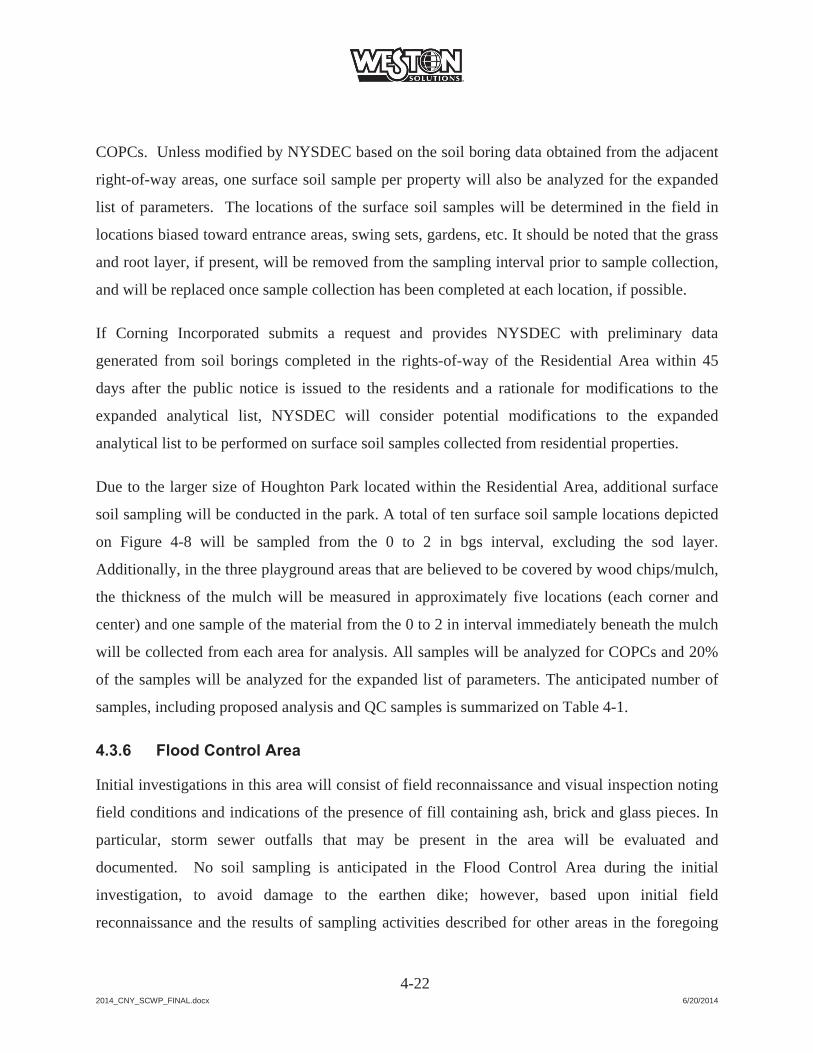
2014_CNY_SCWP_FINAL.docx 6/20/2014
4-22
COPCs. Unless modified by NYSDEC based on the soil boring data obtained from the adjacent
right-of-way areas, one surface soil sample per property will also be analyzed for the expanded
list of parameters. The locations of the surface soil samples will be determined in the field in
locations biased toward entrance areas, swing sets, gardens, etc. It should be noted that the grass
and root layer, if present, will be removed from the sampling interval prior to sample collection,
and will be replaced once sample collection has been completed at each location, if possible.
If Corning Incorporated submits a request and provides NYSDEC with preliminary data
generated from soil borings completed in the rights-of-way of the Residential Area within 45
days after the public notice is issued to the residents and a rationale for modifications to the
expanded analytical list, NYSDEC will consider potential modifications to the expanded
analytical list to be performed on surface soil samples collected from residential properties.
Due to the larger size of Houghton Park located within the Residential Area, additional surface
soil sampling will be conducted in the park. A total of ten surface soil sample locations depicted
on Figure 4-8 will be sampled from the 0 to 2 in bgs interval, excluding the sod layer.
Additionally, in the three playground areas that are believed to be covered by wood chips/mulch,
the thickness of the mulch will be measured in approximately five locations (each corner and
center) and one sample of the material from the 0 to 2 in interval immediately beneath the mulch
will be collected from each area for analysis. All samples will be analyzed for COPCs and 20%
of the samples will be analyzed for the expanded list of parameters. The anticipated number of
samples, including proposed analysis and QC samples is summarized on Table 4-1.
4.3.6 Flood Control Area
Initial investigations in this area will consist of field reconnaissance and visual inspection noting
field conditions and indications of the presence of fill containing ash, brick and glass pieces. In
particular, storm sewer outfalls that may be present in the area will be evaluated and
documented. No soil sampling is anticipated in the Flood Control Area during the initial
investigation, to avoid damage to the earthen dike; however, based upon initial field
reconnaissance and the results of sampling activities described for other areas in the foregoing

2014_CNY_SCWP_FINAL.docx 6/20/2014
4-23
sections, NYSDEC may request and/or Corning Incorporated may propose limited sampling in
this area.

2014_CNY_SCWP_FINAL.docx 6/20/2014
SECTION 4
FIGURES
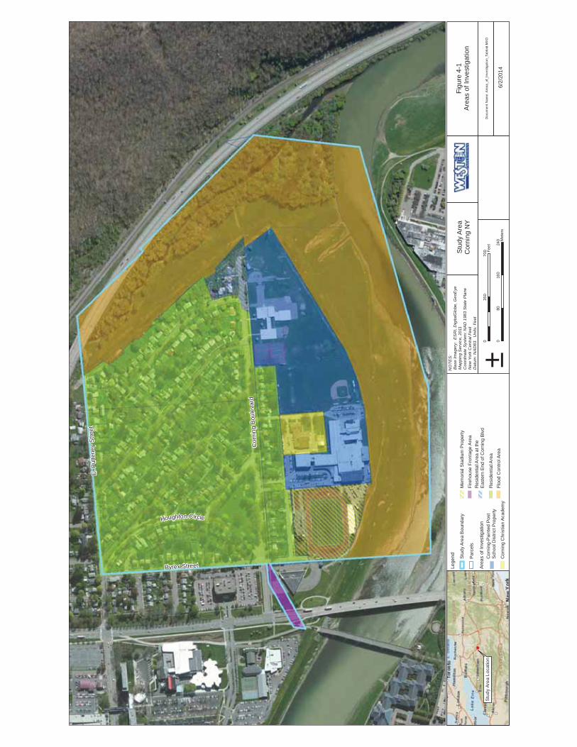
Cor
ning
Bou
leva
rd
Pyrex Street
E. P
ulte
ney
Stre
et
Houghton Circle
Figu
re 4
-1Ar
eas
of In
vest
igat
ion
6/2/
2014
±0
8016
024
0 Met
ers
035
070
0 Feet
NO
TES:
Bas
e Im
ager
y: E
SRI,
Dig
italG
lobe
, Geo
Eye
Map
ping
Ser
vice,
201
1 C
oord
inat
e Sy
stem
: NAD
198
3 St
ate
Plan
e N
ew Y
ork
Cen
tral F
eet
Dat
um: N
AD83
. Un
its: F
eet
Doc
umen
t Nam
e: A
reas
_of_
Inve
stig
atio
n_Ta
bloi
d.M
XD
Man
gane
se R
esul
tsLe
gend Stu
dy A
rea
Bou
ndar
y
Par
cels
Area
s of
Inve
stig
atio
nC
orni
ng-P
aint
ed P
ost
Sch
ool D
istri
ct P
rope
rty
Cor
ning
Chr
istia
n A
cade
my
Mem
oria
l Sta
dium
Pro
perty
Fire
hous
e Fr
onta
ge A
rea
Res
iden
tial A
rea
at th
e E
aste
rn E
nd o
f Cor
ning
Blv
d
Res
iden
tial A
rea
Floo
d C
ontro
l Are
a
Stu
dy A
rea
Loca
tion
Stud
y Ar
eaC
orni
ng N
Y
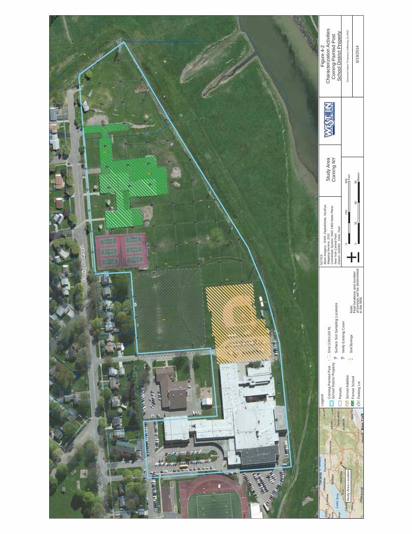
!.
!.
!.
!.
!.
!.
!.
!.
!.
!.
!.!.
!.
!.
!?
!?
!?!?
!?
!?
!?!?
!?!?
!?!?
!?!?
!?!?
!?!?
!?
!?!?
!?!?
!?!?
!?!?
!?
!?
!?!?
!?!?
!?!?
!?!?
!?
!?
!?!?
!?!?
!?!?
!?!?
!?!?
!?!?
!?!?
!?!?
!?!?
!?!?
!?!?
!?!?
!?!?
!?!? !? !? !?
!?!?
!?!?
!?!?
!?
!?!?
!?!?
!?
!?!?
!?!?
!?!?
!?!?
!?!?
!?!?
!?!?
!?!?
!?!?
!?!?
!?!?
!?
!?!?
!?!?
!?!?
!?
!?!?
!?!?
!?!?
!?!? !? !?
!?!?
Cor
ning
Bou
leva
rd
Figu
re 4
-2C
hara
cter
izat
ion
Act
iviti
esC
orni
ng-P
aint
ed P
ost
Scho
ol D
istri
ct P
rope
rty
6/19
/201
4±
030
6090
Met
ers
015
030
0 Feet
NO
TES:
Bas
e Im
ager
y: E
SRI,
Dig
italG
lobe
, Geo
Eye
Map
ping
Ser
vice,
201
1 C
oord
inat
e Sy
stem
: NAD
198
3 St
ate
Plan
e N
ew Y
ork
Cen
tral F
eet
Dat
um: N
AD83
. Un
its: F
eet
Doc
umen
t Nam
e: P
ropo
sed_
Soi
lbor
ing_
A1.
MX
D
Man
gane
se R
esul
tsLe
gend Cor
ning
-Pai
nted
Pos
tS
choo
l Dis
trict
Pro
perty
Par
cels
Sch
ool A
dditi
on
Form
er S
choo
l
Par
king
Lot
Grid
(100
x100
ft)
!?S
urfa
ce S
oil S
ampl
ing
Loca
tions
!?Ve
rify
Exi
stin
g C
over
!.S
oil B
orin
gsN
ote:
Fina
l loc
atio
ns a
nd n
umbe
r of
bor
ings
will
be
dete
rmin
ed
in th
e fie
ld.
Stu
dy A
rea
Loca
tion
Stud
y Ar
eaC
orni
ng N
Y
!.!.
!?
!?
!?
!?
!?
!?
!? !?
!?
!?
!?
!?
!?
!?!?
!?!?
!?!?!?
!?!?
!?!?
!?!?
Figu
re 4
-3C
hara
cter
izat
ion
Act
iviti
esC
orni
ng C
hris
tian
Aca
dem
y Pr
oper
ty
6/19
/201
4±
010
2030
Met
ers
075
150 Fe
et
NO
TES:
Bas
e Im
ager
y: E
SRI,
Dig
italG
lobe
, Geo
Eye
Map
ping
Ser
vice,
201
1 C
oord
inat
e Sy
stem
: NAD
198
3 St
ate
Plan
e N
ew Y
ork
Cen
tral F
eet
Dat
um: N
AD83
. Un
its: F
eet
Doc
umen
t Nam
e: P
ropo
sed_
Soi
lbor
ing_
A2.
MX
D
Man
gane
se R
esul
tsLe
gend Cor
ning
Chr
istia
n A
cade
my
Pro
perty
Par
cels
Grid
(100
x100
ft)
!?S
urfa
ce S
oil S
ampl
ing
Loca
tions
!?Ve
rify
Exi
stin
g C
over
!.S
oil B
orin
gs
Not
e:Fi
nal l
ocat
ions
and
num
ber o
f bor
ings
will
be
dete
rmin
ed in
the
field
.
Stu
dy A
rea
Loca
tion
Stud
y Ar
eaC
orni
ng N
Y
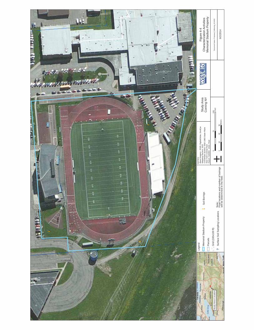
!?
!?
!?!?
!?
!?!?
!?
!?
!?
!?!?
!? !? !?
!?
!?
!.
!.
!.
Figu
re 4
-4C
hara
cter
izat
ion
Act
iviti
esM
emor
ial S
tadi
um P
rope
rty
6/2/
2014
±0
1020
30M
eter
s
075
150 Fe
et
NO
TES:
Bas
e Im
ager
y: E
SRI,
Dig
italG
lobe
, Geo
Eye
Map
ping
Ser
vice,
201
1 C
oord
inat
e Sy
stem
: NAD
198
3 St
ate
Plan
e N
ew Y
ork
Cen
tral F
eet
Dat
um: N
AD83
. Un
its: F
eet
Doc
umen
t Nam
e: P
ropo
sed_
Soi
lbor
ing_
A3.
MX
D
Man
gane
se R
esul
tsLe
gend M
emor
ial S
tadi
um P
rope
rty
Parc
els
Grid
(100
x100
ft)
!?Su
rface
Soi
l Sam
plin
g Lo
catio
ns
!.So
il B
orin
gs
Not
e:Fi
nal l
ocat
ions
and
num
ber o
f bor
ings
will
be
dete
rmin
ed in
the
field
.
Stu
dy A
rea
Loca
tion
Stud
y Ar
eaC
orni
ng N
Y

!?!?
!?!?
!?
!.
!.
!.
Cor
ning
Bou
leva
rd
Pyrex Street
Figu
re 4
-5C
hara
cter
izat
ion
Act
iviti
esFi
reho
use
Fron
tage
Pro
perty
6/2/
2014
±0
1020
30M
eter
s
075
150 Fe
et
NO
TES:
Bas
e Im
ager
y: E
SRI,
Dig
italG
lobe
, Geo
Eye
Map
ping
Ser
vice,
201
1 C
oord
inat
e Sy
stem
: NAD
198
3 St
ate
Plan
e N
ew Y
ork
Cen
tral F
eet
Dat
um: N
AD83
. Un
its: F
eet
Doc
umen
t Nam
e: P
ropo
sed_
Soi
lbor
ing_
A4.
MX
D
Man
gane
se R
esul
tsLe
gend Fi
reho
use
Fron
tage
Pro
perty
Parc
els
Grid
(100
x100
ft)
!.So
il B
orin
gs
!?Su
rface
Soi
l Sam
plin
g Lo
catio
ns
Not
e:Fi
nal l
ocat
ions
and
num
ber o
f bor
ings
will
be
dete
rmin
ed in
the
field
.
Stu
dy A
rea
Loca
tion
Stud
y Ar
eaC
orni
ng N
Y

$1
$1
$1
$1$1
$1
$1
$1
$1 $1
$1
!?
Cor
ning
Bou
leva
rd
Figu
re 4
-6C
hara
cter
izat
ion
Act
iviti
esR
esid
entia
l Are
a at
the
East
ern
End
of C
orni
ng B
oule
vard
6/2/
2014
±0
1020
30M
eter
s
075
150 Fe
et
NO
TES:
Bas
e Im
ager
y: E
SRI,
Dig
italG
lobe
, Geo
Eye
Map
ping
Ser
vice,
201
1 C
oord
inat
e Sy
stem
: NAD
198
3 St
ate
Plan
e N
ew Y
ork
Cen
tral F
eet
Dat
um: N
AD83
. Un
its: F
eet
Doc
umen
t Nam
e: P
ropo
sed_
Soi
lbor
ing_
A5.
MX
D
Man
gane
se R
esul
tsLe
gend Res
iden
tial A
rea
at th
eEa
ster
n E
nd o
f Cor
ning
Boul
evar
d
Parc
els
Area
of P
oten
tial H
isto
ricD
istu
rban
ce
$1So
il B
orin
gs a
nd S
urfa
ceSo
il S
ampl
es
!?Su
rface
Soi
l Sam
plin
g Lo
catio
nsN
ote:
Fina
l loc
atio
ns a
nd n
umbe
rof
bor
ings
will
be
dete
rmin
edin
the
field
.
Stu
dy A
rea
Loca
tion
Stud
y Ar
eaC
orni
ng N
Y

!.
!.
!.
!.
!.!.
!.!.
!.
!.
!.
!.
!.
!.!.
!.
!.
!.
!.
!.
!.!.
!.
!.
!.!.
!?!? !? !?
!?!?!?
!?!?
!?!?
!?!? !?
!?
!?
!?
!?
!?!? !?
!?
!?!?!?
Cor
ning
Bou
leva
rd
Pyrex Street
E. P
ulte
ney
Stre
et
Houghton Circle
Figu
re 4
-7C
hara
cter
izat
ion
Act
iviti
esR
esid
entia
l Are
a
6/19
/201
4±
040
8012
0 Met
ers
020
040
0 Feet
NO
TES:
Bas
e Im
ager
y: E
SRI,
Dig
italG
lobe
, Geo
Eye
Map
ping
Ser
vice,
201
1 C
oord
inat
e Sy
stem
: NAD
198
3 St
ate
Plan
e N
ew Y
ork
Cen
tral F
eet
Dat
um: N
AD83
. Un
its: F
eet
Doc
umen
t Nam
e: P
ropo
sed_
Soi
lbor
ing_
A6.
MX
D
Man
gane
se R
esul
tsLe
gend Res
iden
tial A
rea
Par
cels
!?S
urfa
ce S
oil S
ampl
ing
Loca
tions
!?Ve
rify
Exi
stin
g C
over
!.S
oil B
orin
gs
!.S
oil B
orin
gsin
Res
iden
tial A
rea
Eas
tE
nd o
f Cor
ning
Blv
d
Stud
y Ar
eaC
orni
ng N
Y
Stu
dy A
rea
Loca
tion
Not
e:Fi
nal l
ocat
ions
and
num
ber o
f bor
ings
will
be d
eter
min
ed in
the
field
.
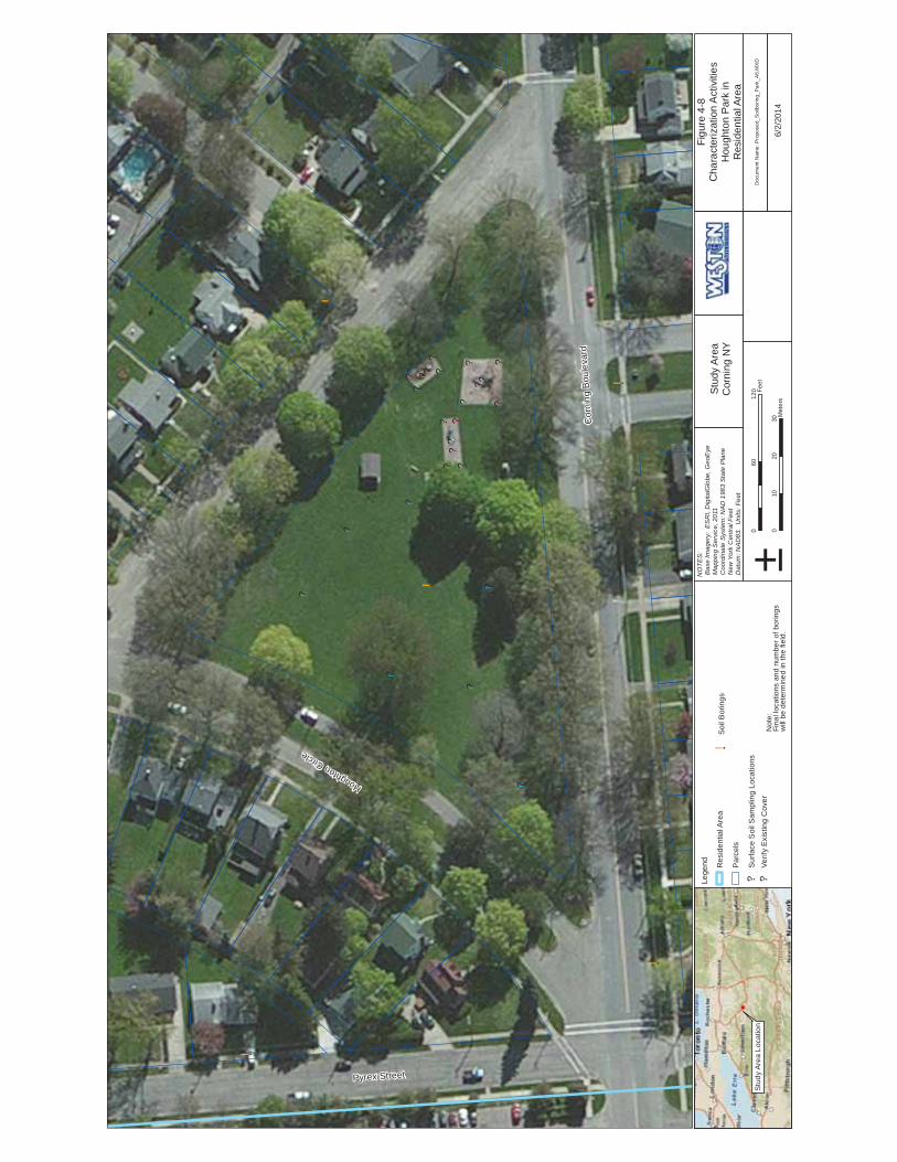
!.
!.
!.
!.
!.
!?
!?
!?
!?
!? !?
!?
!?
!? !?!?!?
!?!?
!?
!?
!?
!?
!?!?
!?
!?
!?
!?
!?
Cor
ning
Bou
leva
rd
Pyrex Street
Houghton Circle
Figu
re 4
-8C
hara
cter
izat
ion
Act
iviti
esH
ough
ton
Park
inR
esid
entia
l Are
a
6/2/
2014
±0
1020
30M
eter
s
060
120 Fe
et
NO
TES:
Bas
e Im
ager
y: E
SRI,
Dig
italG
lobe
, Geo
Eye
Map
ping
Ser
vice,
201
1 C
oord
inat
e Sy
stem
: NAD
198
3 St
ate
Plan
e N
ew Y
ork
Cen
tral F
eet
Dat
um: N
AD83
. Un
its: F
eet
Doc
umen
t Nam
e: P
ropo
sed_
Soi
lbor
ing_
Par
k_A
6.M
XD
Man
gane
se R
esul
tsLe
gend Res
iden
tial A
rea
Par
cels
!?S
urfa
ce S
oil S
ampl
ing
Loca
tions
!?Ve
rify
Exi
stin
g C
over
!.S
oil B
orin
gs
Not
e:Fi
nal l
ocat
ions
and
num
ber o
f bor
ings
will
be d
eter
min
ed in
the
field
.
Stu
dy A
rea
Loca
tion
Stud
y Ar
eaC
orni
ng N
Y

Cor
ning
Bou
leva
rd
Pyrex Street
E. P
ulte
ney
Stre
et
Houghton Circle
Figu
re 4
-9Fl
ood
Con
trol A
rea
6/2/
2014
±0
8016
024
0 Met
ers
035
070
0 Feet
NO
TES:
Bas
e Im
ager
y: E
SRI,
Dig
italG
lobe
, Geo
Eye
Map
ping
Ser
vice,
201
1 C
oord
inat
e Sy
stem
: NAD
198
3 St
ate
Plan
e N
ew Y
ork
Cen
tral F
eet
Dat
um: N
AD83
. Un
its: F
eet
Man
gane
se R
esul
tsLe
gend Fl
ood
Con
trol A
rea
Par
cels
Not
e:Fi
nal l
ocat
ions
and
num
ber o
f bor
ings
will
be
dete
rmin
ed in
the
field
.
Stu
dy A
rea
Loca
tion
Doc
umen
t Nam
e: P
ropo
sed_
Soi
lbor
ing_
A8.
MX
D
Stud
y Ar
eaC
orni
ng N
Y

2014_CNY_SCWP_FINAL.docx 6/20/2014
SECTION 4
TABLES
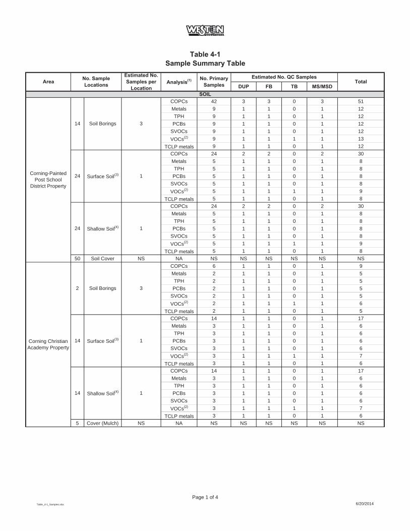
Table 4-1Sample Summary Table
DUP FB TB MS/MSD
COPCs 42 3 3 0 3 51Metals 9 1 1 0 1 12TPH 9 1 1 0 1 12
PCBs 9 1 1 0 1 12SVOCs 9 1 1 0 1 12VOCs(2) 9 1 1 1 1 13
TCLP metals 9 1 1 0 1 12COPCs 24 2 2 0 2 30Metals 5 1 1 0 1 8TPH 5 1 1 0 1 8
PCBs 5 1 1 0 1 8SVOCs 5 1 1 0 1 8VOCs(2) 5 1 1 1 1 9
TCLP metals 5 1 1 0 1 8COPCs 24 2 2 0 2 30Metals 5 1 1 0 1 8TPH 5 1 1 0 1 8
PCBs 5 1 1 0 1 8SVOCs 5 1 1 0 1 8VOCs(2) 5 1 1 1 1 9
TCLP metals 5 1 1 0 1 850 Soil Cover NS NA NS NS NS NS NS NS
COPCs 6 1 1 0 1 9Metals 2 1 1 0 1 5TPH 2 1 1 0 1 5
PCBs 2 1 1 0 1 5SVOCs 2 1 1 0 1 5VOCs(2) 2 1 1 1 1 6
TCLP metals 2 1 1 0 1 5COPCs 14 1 1 0 1 17Metals 3 1 1 0 1 6TPH 3 1 1 0 1 6
PCBs 3 1 1 0 1 6SVOCs 3 1 1 0 1 6VOCs(2) 3 1 1 1 1 7
TCLP metals 3 1 1 0 1 6COPCs 14 1 1 0 1 17Metals 3 1 1 0 1 6TPH 3 1 1 0 1 6
PCBs 3 1 1 0 1 6SVOCs 3 1 1 0 1 6VOCs(2) 3 1 1 1 1 7
TCLP metals 3 1 1 0 1 65 Cover (Mulch) NS NA NS NS NS NS NS NS
Corning-PaintedPost School
District Property
2 Soil Borings 3
1Surface Soil(3)14Corning Christian Academy Property
Surface Soil(3) 1
24 Shallow Soil(4) 1
14 Soil Borings 3
Total
SOIL
Area No. Sample Locations
Estimated No. Samples per
LocationAnalysis(1) No. Primary
SamplesEstimated No. QC Samples
24
14 Shallow Soil(4) 1
Table_4-1_Samples.xlsx
Page 1 of 46/20/2014
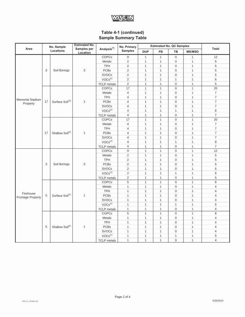
Table 4-1 (continued)Sample Summary Table
DUP FB TB MS/MSDTotalArea No. Sample
Locations
Estimated No. Samples per
LocationAnalysis(1) No. Primary
SamplesEstimated No. QC Samples
COPCs 9 1 1 0 1 12Metals 2 1 1 0 1 5TPH 2 1 1 0 1 5
PCBs 2 1 1 0 1 5SVOCs 2 1 1 0 1 5VOCs(2) 2 1 1 1 1 6
TCLP metals 2 1 1 0 1 5COPCs 17 1 1 0 1 20Metals 4 1 1 0 1 7TPH 4 1 1 0 1 7
PCBs 4 1 1 0 1 7SVOCs 4 1 1 0 1 7VOCs(2) 4 1 1 1 1 8
TCLP metals 4 1 1 0 1 7COPCs 17 1 1 0 1 20Metals 4 1 1 0 1 7TPH 4 1 1 0 1 7
PCBs 4 1 1 0 1 7SVOCs 4 1 1 0 1 7VOCs(2) 4 1 1 1 1 8
TCLP metals 4 1 1 0 1 7COPCs 9 1 1 0 1 12Metals 2 1 1 0 1 5TPH 2 1 1 0 1 5
PCBs 2 1 1 0 1 5SVOCs 2 1 1 0 1 5VOCs(2) 2 1 1 1 1 6
TCLP metals 2 1 1 0 1 5COPCs 5 1 1 0 1 8Metals 1 1 1 0 1 4TPH 1 1 1 0 1 4
PCBs 1 1 1 0 1 4SVOCs 1 1 1 0 1 4VOCs(2) 1 1 1 1 1 5
TCLP metals 1 1 1 0 1 4COPCs 5 1 1 0 1 8Metals 1 1 1 0 1 4TPH 1 1 1 0 1 4
PCBs 1 1 1 0 1 4SVOCs 1 1 1 0 1 4VOCs(2) 1 1 1 1 1 5
TCLP metals 1 1 1 0 1 4
1
FirehouseFrontage Property
3 Soil Borings 3
5 Surface Soil(3) 1
5 Shallow Soil(4)
17 1
17 1
Memorial Stadium Property Surface Soil(3)
Shallow Soil(4)
3Soil Borings3
Table_4-1_Samples.xlsx
Page 2 of 46/20/2014

Table 4-1 (continued)Sample Summary Table
DUP FB TB MS/MSDTotalArea No. Sample
Locations
Estimated No. Samples per
LocationAnalysis(1) No. Primary
SamplesEstimated No. QC Samples
COPCs 33 2 2 0 2 39Metals 15 1 1 0 1 18TPH 15 1 1 0 1 18
PCBs 15 1 1 0 1 18SVOCs 15 1 1 0 1 18VOCs(2) 15 1 1 1 1 19
TCLP metals 15 1 1 0 1 18COPCs 12 1 1 0 1 15Metals 5 1 1 0 1 8TPH 5 1 1 0 1 8
PCBs 5 1 1 0 1 8SVOCs 5 1 1 0 1 8VOCs(2) 5 1 1 1 1 9
TCLP metals 5 1 1 0 1 8COPCs 72 4 4 0 4 84Metals 15 1 1 0 1 18TPH 15 1 1 0 1 18
PCBs 15 1 1 0 1 18SVOCs 15 1 1 0 1 18VOCs(2) 15 1 1 1 1 19
TCLP metals 15 1 1 0 1 18COPCs 866 44 44 0 44 998Metals 214 11 11 0 11 247TPH 214 11 11 0 11 247
PCBs 214 11 11 0 11 247SVOCs 214 11 11 0 11 247VOCs(2) 214 11 11 1 11 248
TCLP metals 214 11 11 0 11 24715 Cover (Mulch) NS NA NS NS NS NS NS NS
3,594
12 Surface Soil(3) 1
Residential Area at East End of Corning Blvd
Soil Borings24 3
Residential Area (including
Houghton Park)
11 Soil Borings 3
TOTAL SOIL ANALYSES:
Surface Soil(3)866 1
Table_4-1_Samples.xlsx
Page 3 of 46/20/2014
Table 4-1 (continued)Sample Summary Table
DUP FB TB MS/MSDTotalArea No. Sample
Locations
Estimated No. Samples per
LocationAnalysis(1) No. Primary
SamplesEstimated No. QC Samples
COPCs 10 2 0 0 2 14Metals 2 2 0 0 2 6TPH 2 2 0 0 2 6PAH 2 2 0 0 2 6PCBs 2 2 0 0 2 6VOCs 2 2 0 2 2 8
COPCs 8 2 0 0 2 12Metals 2 2 0 0 2 6TPH 2 2 0 0 2 6PAH 2 2 0 0 2 6PCBs 2 2 0 0 2 6VOCs 2 2 0 2 2 8
90
Notes:(1) - Analytical methods are presented in Table 4-2 and complete analyte lists are presented in Table 4-3.(2) - VOCs collected at highest concentration(s) in borings where photoionization detector readings are >5X background(3) - Surface samples collected from 0 - 2 inches bgs(4) - Shallow samples collected from 2 inches bgs to 2 feet bgsNo samples collected of soil cover - confirmation of existence and thickness onlyTPH - Total Petroleum HydrocarbonsPAH - Polycyclic aromatic hydrocarbonsPCB - Polychlorinated biphenylsCOPCs - Constituents of Potential Concern (i.e., arsenic, cadmium and lead)QA/QC - quality assurance/quality controlDUP - duplicate sampleFB - field blankMS/MSD - matrix spike/matrix spike duplicateTB - trip blankNo. - numberbgs - below ground surfaceNA - not applicable (no analytical samples collected)NS - not sampled
Assumptions:All samples analyzed for list (as shown)All samples analyzed for COPCs, 20% of samples analyzed for full listDUP, FB and MS/MSD collected at 20% TB is 1 per VOC cooler (assume 1 per area)
GROUNDWATER
School Area 5 MonitoringWells 2
Residential Area at East End of Corning Blvd
4 MonitoringWells 2
TOTAL GROUNDWATER ANALYSES:
Table_4-1_Samples.xlsx
Page 4 of 46/20/2014
Table 4-2Analytical Methodologies
COPCs 10 grams, Wide-mouth glass w/Fluoropolymer Resin / Teflon®-lined lid None 6 months
TAL Metals 10 grams, Wide-mouth glass w/Fluoropolymer Resin / Teflon®-lined lid None 6 months
TPH 100 grams, Wide-mouth glass w/Fluoropolymer Resin / Teflon®-lined lid 4°C 28 days
SVOCs 30 grams, Wide-mouth glass w/Fluoropolymer Resin / Teflon®-lined lid 4°C 14 days
TAL PCBs 30 grams, Wide-mouth glass w/Fluoropolymer Resin / Teflon®-lined lidd 4°C 14 days
VOCs WideMouth Jar, TerraCore or EnCore(1) 4°C 14 days
TCLP Metals 100 grams, Wide-mouth glass w/Fluoropolymer Resin / Teflon®-lined lid 4°C 14 days/6 months(2)
TAL Metals 250 mL, Polyethlyene or Glass HN03 to pH < 2 6 months
TPH 1000 mL, Glass with Teflon®-lined cap 4°C, H2S04 or HCI to pH < 2 28 days
PAH 2-250 mL, Glass with Teflon®-lined cap (amber) 4°C 7/40 days(3)
TAL PCBs 2-250 mL, Glass with Teflon®-lined cap (amber) 4°C 7/40 days(3)
VOCs 3-40 mL,Glass with Teflon®-lined septum 4°C, HCL 14 days
Notes:COPCs - Constituents of Potential ConcernTAL - Target Analyte ListTPH - Total Petroleum HydrocarbonsPAH - Polycyclic aromatic hydrocarbonsPCB - Polychlorinated biphenylsVOCs - Volatile Organic CompoundsSGT HEM - Silica Gel Treated N-Hexane Extractable Material TCLP - Toxicity Characteristic Leaching Procedure
(2) 14 days for extraction, 180 days for analysis(3) 7 days for extraction, 40 days for analysis
SW846 8260
(1) There are a number of options for collecting soil samples for volatile analysis. The options include: EnCore® devices, TerraCore® devices, and Wide mouth jars. Compliance with local regulatory requirements is necessary, and if dry weight determination is needed, a separate 2 oz jar must be collected.
SW846 1311 &SW846 6010
Groundwater
SW846846 6010
EPA 1664 (SGT HEM)
SW846 8270
SW846 8082
SW846 6010
SW846 6010
EPA 1664 (SGT HEM)
SW846 8270
SW846 8082
SW846 8260
Analysis Analytical Methods Container Preservation Hold Time
SOIL
Table_4-2.xlsx
Page 1 of 16/20/2014
Table 4-3Reporting Limits and Method Detection Limits
RL MDL RL MDLCOPCs [Method SW846 6010]
Arsenic 2.00 0.400 0.0150 0.00555Cadmium 0.200 0.0300 0.00200 0.000500Lead 1.00 0.240 0.0100 0.00300
Metals [Method SW846 6010]Aluminum 10.0 4.40 0.200 0.0600Antimony 15.0 0.400 0.0200 0.00679Arsenic 2.00 0.400 0.0150 0.00555Barium 0.500 0.110 0.00200 0.000700Beryllium 0.200 0.0280 0.00200 0.000300Boron 2.00 0.190 0.0200 0.00400Cadmium 0.200 0.0300 0.00200 0.000500Calcium 50.0 3.30 0.500 0.100Chromium 0.500 0.200 0.00400 0.00100Cobalt 0.500 0.0500 0.00400 0.000630Copper 1.00 0.210 0.0100 0.00160Iron 10.0 1.10 0.0500 0.0193Lead 1.00 0.240 0.0100 0.00300Magnesium 20.0 0.927 0.200 0.0434Manganese 0.200 0.0320 0.00300 0.000400Nickel 5.00 0.230 0.0100 0.00126Potassium 30.0 20.0 0.500 0.100Selenium 4.00 0.400 0.0250 0.00870Silver 0.600 0.200 0.00600 0.00170Sodium 140 13.0 1.00 0.324Thallium 6.00 0.300 0.0200 0.0102Vanadium 0.500 0.110 0.00500 0.00150Zinc 2.00 0.153 0.0100 0.00150
Total Petroleum Hydrocarbons (TPH) [Method EPA 1664 (SGT HEM)]TPH 100 40.0 5.00 1.94
Semi-Volatile Organic Compounds (SVOCs) [Method SW846 8270]Biphenyl 170 10.5 5.00 0.653bis (2-chloroisopropyl) ether 170 17.6 5.00 0.5202,4,5-Trichlorophenol 170 36.8 5.00 0.4802,4,6-Trichlorophenol 170 11.1 5.00 0.6102,4-Dichlorophenol 170 8.85 5.00 0.5102,4-Dimethylphenol 170 45.6 5.00 0.5002,4-Dinitrophenol 330 59.1 10.0 2.222,4-Dinitrotoluene 170 26.1 5.00 0.4472,6-Dinitrotoluene 170 41.3 5.00 0.4002-Chloronaphthalene 170 11.3 5.00 0.4602-Chlorophenol 170 8.59 5.00 0.5302-Methylphenol 170 5.19 5.00 0.4002-Methylnaphthalene 170 2.04 5.00 0.6002-Nitroaniline 330 54.1 10.0 0.4202-Nitrophenol 170 7.72 5.00 0.4803,3'-Dichlorobenzidine 170 148 5.00 0.4003-Nitroaniline 330 38.8 10.0 0.4804,6-Dinitro-2-methylphenol 330 58.3 10.0 2.204-Bromophenyl phenyl ether 170 53.7 5.00 0.4504-Chloro-3-methylphenol 170 6.94 5.00 0.4504-Chloroaniline 170 49.5 5.00 0.5904-Chlorophenyl phenyl ether 170 3.60 5.00 0.3504-Methylphenol 330 9.40 10.0 0.3604-Nitroaniline 330 18.9 10.0 0.2504-Nitrophenol 330 40.9 10.0 1.52Acenaphthene 170 1.98 5.00 0.410Acenaphthylene 170 1.38 5.00 0.380Acetophenone 170 8.66 5.00 0.540Anthracene 170 4.32 5.00 0.280Atrazine 170 7.51 5.00 0.460Benzaldehyde 170 18.5 5.00 0.267Benzo[a]anthracene 170 2.91 5.00 0.360Benzo[a]pyrene 170 4.07 5.00 0.470Benzo[b]fluoranthene 170 3.28 5.00 0.340Benzo[g,h,i]perylene 170 2.03 5.00 0.350Benzo[k]fluoranthene 170 1.86 5.00 0.730Bis(2-chloroethoxy)methane 170 9.18 5.00 0.350
mg/Kg mg/L
μg/Lμg/Kg
Soil Groundwater
mg/Kg mg/L
mg/Kg mg/L
Table_4-3.xlsx Page 1 of 3 6/20/2014

Table 4-3 (continued)Reporting Limits and Method Detection Limits
RL MDL RL MDLSoil Groundwater
Semi-Volatile Organic Compounds (SVOCs) [Method SW846 8270] (continued)Bis(2-chloroethyl)ether 170 14.6 5.00 0.400Bis(2-ethylhexyl) phthalate 170 54.4 5.00 1.80Butyl benzyl phthalate 170 45.3 5.00 0.420Caprolactam 170 73.0 5.00 2.20Carbazole 170 1.95 5.00 0.300Chrysene 170 1.69 5.00 0.330Dibenz(a,h)anthracene 170 1.99 5.00 0.420Di-n-butyl phthalate 170 58.3 5.00 0.310Di-n-octyl phthalate 170 3.95 5.00 0.470Dibenzofuran 170 1.76 10.0 0.510Diethyl phthalate 170 5.10 5.00 0.220Dimethyl phthalate 170 4.40 5.00 0.360Fluoranthene 170 2.45 5.00 0.400Fluorene 170 3.89 5.00 0.360Hexachlorobenzene 170 8.39 5.00 0.510Hexachlorobutadiene 170 8.64 5.00 0.680Hexachlorocyclopentadiene 170 51.0 5.00 0.590Hexachloroethane 170 13.1 5.00 0.590Indeno[1,2,3-cd]pyrene 170 4.67 5.00 0.470Isophorone 170 8.44 5.00 0.430N-Nitrosodi-n-propylamine 170 13.4 5.00 0.540N-Nitrosodiphenylamine 170 9.23 5.00 0.510Naphthalene 170 2.81 5.00 0.760Nitrobenzene 170 7.48 5.00 0.290Pentachlorophenol 330 57.9 10.0 2.20Phenanthrene 170 3.54 5.00 0.440Phenol 170 17.8 5.00 0.390Pyrene 170 1.09 5.00 0.3402-Fluorobiphenyl
Polychlorinated Biphenyls (PCBs) [Method SW846 8082]PCB-1016 0.0167 0.00326 0.500 0.176PCB-1221 0.0167 0.00326 0.500 0.176PCB-1232 0.0167 0.00326 0.500 0.176PCB-1242 0.0167 0.00326 0.500 0.176PCB-1248 0.0167 0.00326 0.500 0.176PCB-1254 0.0167 0.00782 0.500 0.250PCB-1260 0.0167 0.00782 0.500 0.250PCB-1262 0.0167 0.00782 0.500 0.250PCB-1268 0.0167 0.00782 0.500 0.250
Volatile Organic Compounds (VOCs) [Method SW846 8260]1,1,1-Trichloroethane 5.00 0.363 1.00 0.8201,1,2,2-Tetrachloroethane 5.00 0.811 1.00 0.2101,1,2-Trichloroethane 5.00 0.650 1.00 0.2301,1,2-Trichloro-1,2,2-trifluoroethane 5.00 1.14 1.00 0.3101,1-Dichloroethane 5.00 0.610 1.00 0.3801,1-Dichloroethene 5.00 0.612 1.00 0.2901,2,4-Trichlorobenzene 5.00 0.304 1.00 0.4101,2-Dibromo-3-Chloropropane 5.00 2.50 1.00 0.3901,2-Dichlorobenzene 5.00 0.391 1.00 0.7901,2-Dichloroethane 5.00 0.251 1.00 0.2101,2-Dichloropropane 5.00 2.50 1.00 0.7201,3-Dichlorobenzene 5.00 0.257 1.00 0.7801,4-Dichlorobenzene 5.00 0.700 1.00 0.8402-Butanone (MEK) 25.0 1.83 10.0 1.322-Hexanone 25.0 2.50 5.00 1.244-Methyl-2-pentanone (MIBK) 25.0 1.64 5.00 2.10Acetone 25.0 4.21 10.0 3.00Benzene 5.00 0.245 1.00 0.410Bromodichloromethane 5.00 0.670 1.00 0.390Bromoform 5.00 2.50 1.00 0.260Bromomethane 5.00 0.450 1.00 0.690Carbon disulfide 5.00 2.50 1.00 0.190Carbon tetrachloride 5.00 0.484 1.00 0.270Chlorobenzene 5.00 0.660 1.00 0.750Dibromochloromethane 5.00 0.640 1.00 0.320Chloroethane 5.00 1.13 1.00 0.320Chloroform 5.00 0.309 1.00 0.340
mg/Kg ug/L
ug/Kg ug/L
μg/Kg μg/L
Table_4-3.xlsx Page 2 of 3 6/20/2014
Table 4-3 (continued)Reporting Limits and Method Detection Limits
RL MDL RL MDLSoil Groundwater
Volatile Organic Compounds (VOCs) [Method SW846 8260] (continued)Chloromethane 5.00 0.302 1.00 0.350cis-1,2-Dichloroethene 5.00 0.640 1.00 0.810cis-1,3-Dichloropropene 5.00 0.720 1.00 0.360Cyclohexane 5.00 0.700 1.00 0.180Dichlorodifluoromethane 5.00 0.413 1.00 0.680Ethylbenzene 5.00 0.345 1.00 0.7401,2-Dibromoethane 5.00 0.642 1.00 0.730Isopropylbenzene 5.00 0.754 1.00 0.790Methyl acetate 5.00 0.930 2.50 0.500Methyl tert-butyl ether 5.00 0.491 1.00 0.160Methylcyclohexane 5.00 0.760 1.00 0.160Methylene Chloride 5.00 2.30 1.00 0.440Styrene 5.00 0.250 1.00 0.730Tetrachloroethene 5.00 0.671 1.00 0.360Toluene 5.00 0.378 1.00 0.510trans-1,2-Dichloroethene 5.00 0.516 1.00 0.900trans-1,3-Dichloropropene 5.00 2.20 1.00 0.370Trichloroethene 5.00 1.10 1.00 0.460Trichlorofluoromethane 5.00 0.473 1.00 0.880Vinyl chloride 5.00 0.610 1.00 0.900Xylenes, Total 10.0 0.840 2.00 0.660
TCLP Metals [Method SW846 6010]Aluminum 0.200 0.0600 -- --Antimony 0.0200 0.00679 -- --Arsenic 0.0150 0.00555 -- --Barium 0.00200 0.000700 -- --Beryllium 0.00200 0.000300 -- --Boron 0.0200 0.00400 -- --Cadmium 0.00200 0.000500 -- --Calcium 0.500 0.100 -- --Chromium 0.00400 0.00100 -- --Cobalt 0.00400 0.000630 -- --Copper 0.0100 0.00160 -- --Iron 0.0500 0.0193 -- --Lead 0.0100 0.00300 -- --Magnesium 0.200 0.0434 -- --Manganese 0.00300 0.000400 -- --Nickel 0.0100 0.00126 -- --Potassium 0.500 0.100 -- --Selenium 0.0250 0.00870 -- --Silver 0.00600 0.00170 -- --Sodium 1.00 0.324 -- --Thallium 0.0200 0.0102 -- --Vanadium 0.00500 0.00150 -- --Zinc 0.0100 0.00150 -- --
Notes:mg/Kg - milligram per kilogramug/Kg - microgram per kilogrammg/L- milligram per literug/L - microgram per liter
mg/L --
ug/Kg ug/L
Table_4-3.xlsx Page 3 of 3 6/20/2014
2014_CNY_SCWP_FINAL.docx 6/20/2014
5-1
5. PROJECT MANAGEMENT
5.1 SCHEDULE
The activities described in this Work Plan are expected to be performed following the effective
date of the Order between Corning Incorporated and NYSDEC and upon receipt of consent to
access from property owners. The characterization activities will occur in a phased approach and
the anticipated project schedule is provided as Figure 5-1. It should be noted that the planned
activities are not independent and the proposed schedule and approach may be adjusted
accordingly as work is completed within the Study Area. The schedule will be updated bi-weekly
and submitted to NYSDEC and NYSDOH. Furthermore, this work schedule is predicated on
obtaining written access consent from property owners in a timely fashion.
5.2 DOCUMENTATION
5.2.1 Field Logs
Essential project information pertinent to field activities, including sampling, will be recorded in
bound field logbooks with consecutively numbered pages and/or field data record forms specific
to a given activity. Entries into the logbook will contain a variety of information, such as:
Date and time of logbook entry
Names of all team members present
Weather conditions
Field observations
Log and summary of daily activities and significant events
Description of sample and sampling location
Date and time of sample collection
Collector’s sample identification number(s) and/or name
Name and affiliation of personnel or visitors
Decontamination activities
Description of any problem encountered and problem resolution

2014_CNY_SCWP_FINAL.docx 6/20/2014
5-2
Entries will be made in ink with no erasures. If an incorrect entry is made, the information will
be crossed out with a single strike mark, initialed, and dated.
5.2.2 Photo Log
A project photo log will be prepared and maintained throughout the characterization activities to
provide photo documentation of field activities. In particular, photos of the soil boring cores will
be collected and logged.
5.2.3 Field Reports
WESTON will prepare brief daily work activity reports concisely summarizing the work
performed each day. At the completion of the work, all record documents will be provided to
Corning Incorporated. NYSDEC and NYSDOH will be provided verbal updates of the field
activities periodically and electronic copies of weekly work activity reports, including select
supporting photographs. All ambient air monitoring data will be recorded in the site field
logbook or designated field sheets and the results of the air monitoring will be communicated to
the NYSDEC and NYSDOH on scheduled basis (i.e. daily for levels which require actions,
weekly for routine monitoring data).
5.2.4 Data Management
Laboratory analytical data will be managed by WESTON in an electronic database and will be
uploaded in an electronic data deliverable (EDD) format. All data obtained during the
characterization activities will be summarized in a Study Area Characterization Report and the
associated laboratory analytical data packages will be included as an attachment.
Laboratory data deliverable packages will be reviewed for completeness, adherence to holding
times, comparison with chain-of-custody, etc. Data validation will be performed, and a data
usability summary report (DUSR) will be prepared. The data review/validation activities are
described in the QAPP provided in Appendix C.
2014_CNY_SCWP_FINAL.docx 6/20/2014
5-3
5.2.5 Reporting
Following implementation of characterization investigation activities, a Study Area
Characterization Report documenting the investigation activities and findings will be prepared
and submitted to NYSDEC. This report will include a summary of the activities, including a
description of any deviations from the proposed work plan, as well as the submission of
analytical results including the results of the QA/QC samples.
The aforementioned report will typically contain the following information:
Tables summarizing sample analytical results. Final laboratory data packages will be appended to this report.
Summary table presenting depth to water measurements and water level elevations at the Study Area monitoring wells.
Maps showing soil and groundwater sampling locations.
Water level elevation contour map prepared using data collected from the monitoring wells.
Stratigraphic boring logs and monitor well construction summaries.
Discussion of the sampling results and significance of findings.
Upon receipt of validated data as it is generated throughout the project, Corning Incorporated
will supply such validated data to NYSDEC. NYSDEC will review the data and Corning
Incorporated’s proposed letters before they are provided to individual property owners.
5.3 HEALTH AND SAFETY PLAN
The health and safety of field workers, clients, and the community are of utmost importance. For
the field work, it is planned that workers will be in Level D personal protection (i.e., coveralls or
work clothes, work boots, safety glasses, and hard hats). All field activities will be conducted in
accordance with the Study Area Health and Safety Plan (HASP) and Community Air Monitoring
Plan (CAMP) provided in Appendix A and Appendix B, respectively.
2014_CNY_SCWP_FINAL.docx 6/20/2014
5-4
5.4 STUDY AREA CONTROLS
The first activities will involve mobilization of personnel and equipment. A temporary field
office and equipment staging area will be set up near the Study Area. This temporary field office
area will be surrounded by temporary fencing for security. The office area and access gate will
be closed and locked when not in use. The location of the temporary field office and equipment
storage area will be determined based on the written access consent agreements.
The temporary field office area will consists of an office trailer for document and sample
preparation, and staging area for field equipment. Electricity will be supplied to the mobile office
via either a power drop or a generator.
5.5 COMMUNITY RELATIONS
A Citizen Participation Plan (CPP) for the Study Area has been prepared in accordance with
DER-10 requirements and submitted to the NYSDEC. The CPP describes the community
relations components to be followed during the implementation of this Work Plan and other
Study Area related activities.

2014_CNY_SCWP_FINAL.docx 6/20/2014
SECTION 5
FIGURES

CHAR
ACTE
RIZA
TIO
NW
ORK
PLAN
PRO
POSE
DSC
HEDU
LE1
WEE
KSTA
SKEV
ENT
12
34
56
78
910
1112
1314
1516
1718
1920
2122
2324
2526
2728
2930
3132
3334
3536
3738
3940
4142
4344
4546
4748
4950
5152
5354
5556
Con
sent
Ord
erPu
blic
Mee
ting
Mob
iliza
tion
Obt
ain
Writ
ten
Acc
ess C
onse
nt &
Cle
aran
ces
Geo
phys
ical
Sur
vey
Soil
Bor
ing
Sam
plin
gSo
il B
orin
g Sa
mpl
e A
naly
sis &
Val
idat
ion
Dat
a R
epor
t for
Sch
ool D
istri
ct p
rope
rty (S
oil B
orin
g / G
eoph
ysic
s)2
Surf
ace
Soil
(mea
sure
men
t & sa
mpl
ing)
Surf
ace
Soil
Sam
ple
Ana
lysi
s & V
alid
atio
nD
ata
Rep
ort f
or S
choo
l Dis
trict
pro
perty
(Sur
face
Soi
l)2
Pote
ntia
l Gro
undw
ater
Inst
alla
tion,
Sam
plin
g an
d R
epor
ting
Obt
ain
Writ
ten
Acc
ess C
onse
nt &
Cle
aran
ces
Soil
Bor
ing
& S
urfa
ce S
oil S
ampl
ing
Sam
ple
Ana
lysi
s & V
alid
atio
nD
ata
Rep
ort f
or C
orni
ng C
hris
tian
Aca
dem
y pr
oper
ty2
Obt
ain
Writ
ten
Acc
ess C
onse
nt &
Cle
aran
ces
Soil
Bor
ing
& S
urfa
ce S
oil S
ampl
ing
Sam
ple
Ana
lysi
s & V
alid
atio
nD
ata
Rep
ort f
or C
ity o
f Cor
ning
2
Obt
ain
Writ
ten
Acc
ess C
onse
nt &
Cle
aran
ces
Sam
ple
Ana
lysi
s & V
alid
atio
nD
ata
repo
rts to
Pro
perty
Ow
ners2
Pote
ntia
l Gro
undw
ater
Inst
alla
tion,
Sam
plin
g an
d R
epor
ting
Obt
ain
Writ
ten
Acc
ess C
onse
nt (C
ity o
f Cor
ning
) & C
lear
ance
sSo
il B
orin
g Sa
mpl
ing
(Rig
ht-o
f-W
ay A
reas
)R
OW
Soi
l Bor
ing
Sam
ple
Ana
lysi
s & V
alid
atio
nD
ata
Rep
ort t
o C
ity o
f Cor
ning
2
Obt
ain
Writ
ten
Acc
ess C
onse
nt (P
rope
rty O
wne
rs -
Phas
e I)
& C
lear
ance
sSu
rfac
e So
il Sa
mpl
ing
(Pha
se I)
Surf
ace
Soil
Sam
ple
Ana
lysi
s & V
alid
atio
nD
ata
Rep
ort f
or P
rope
rty O
wne
rs2
Obt
ain
Writ
ten
Acc
ess C
onse
nt (P
rope
rty O
wne
rs -
Phas
e II
) & C
lear
ance
sSu
rfac
e So
il Sa
mpl
ing
(Pha
se II
)Su
rfac
e So
il Sa
mpl
e A
naly
sis &
Val
idat
ion
Dat
a R
epor
t for
Pro
perty
Ow
ners2
Obt
ain
Writ
ten
Acc
ess C
onse
ntFi
eld
Rec
onna
issa
nce
Prep
are
Dra
ft C
hara
cter
izat
ion
Rep
ort
NY
SDEC
Com
men
tsPr
epar
e Fi
nal C
hara
cter
izat
ion
Rep
ort
Not
es:
1Sc
hedu
leis
pred
icat
edup
onob
tain
ing
writ
ten
acce
ssco
nsen
tfro
mpr
oper
tyow
ners
2As
sum
ed2
wee
ksfo
rNYS
DCE
revi
ewof
subm
ittal
s.
Figu
re5
1Pr
ojec
tSch
edul
e
Soil
Bor
ing
& S
urfa
ce S
oil S
ampl
ing
Initi
alSt
artu
p
Corn
ing
Pain
ted
Post
Scho
olDi
stric
tPr
oper
ty
Sum
mar
yRe
port
Resi
dent
ialA
rea
atth
eEa
stEn
dof
Corn
ing
Blvd
Floo
dCo
ntro
lAre
a
Resi
dent
ialA
rea
Corn
ing
Chris
tian
Acad
emy
Mem
oria
lSta
dium
&Fi
reho
use
Fron
tage
2014
0602
_CN
Y_SC
WP_
Sche
dule
_FIN
AL.x
lsx

2014_CNY_SCWP_FINAL.docx 6/20/2014
6-1
6. REFERENCES
Aerial photograph of the Corning, New York area, August 8, 1938
Aerial photograph of the Corning, New York area, May 8, 1942
Aerial photograph of the Corning, New York area, April 16, 1952
Aerial photograph of the Corning, New York area, July 11, 1955
Aerial photograph of the Corning, New York area, October 8, 1964
Aerial photograph of the Corning, New York area, March 30, 1968
Aerial photograph of the Corning, New York area, March/April 2011
Edinger, G.J., D.J. Evans, S. Gebauer, T.G. Howard, D.M. Hunt, and A.M. Olivero (editors). 2002. Ecological Communities of New York State. Second Edition. A revised and expanded edition of Carol Reschke's Ecological Communities of New York State. (Draft for review). New York Natural Heritage Program, New York State Department of Environmental Conservation, Albany, NY. http://www.dec.ny.gov/animals/29392.html accessed 3/6/2014.
Dimitroff 1991, Dimitroff T.P. and L.S. Janes. 1991. History of the Corning-Painted Post Area: 200 Years in Painted Post Country. Bookmarks Publishing, London, UK.
FEMA 2002, Federal Emergency Management Agency. 2002. Firm Flood Insurance Rate Map,City of Corning, New York.
Haley & Aldrich, Incorporated. (2014, March 3). Corning East High- Status [E-mail [email protected]], [email protected].
Miller, T.S., Belli, J.L., Allen, R.V. Geohydrology of the valley-fill aquifer in the Corning area, Steuben County, New York, 1982.
NYSDEC. 2014. Environmental Resource Mapper. http://www.dec.ny.gov/imsmaps/ERM/viewer.htm accessed 3/10/2014.
Olcot, Perry G., USGS. Groundwater Atlas of the United States. Connecticut, Maine, Massachusetts, New Hampshire, New York, Rhode Island, Vermont, 1995.
Sinclair, Estelle F., Spillman, Jane Shadel. 1997 The Complete Cut & Engraved Glass of Corning. Syracuse University Press, 3/28/1997
Steuben County Clerk’s Office, Book 368 of Deeds, page 201, November 1, 1920
Steuben County Clerk’s Office, Book 465 of Deeds, page 310, October 6, 1937

2014_CNY_SCWP_FINAL.docx 6/20/2014
6-2
UASCE 1939, Southern New York Flood Control Project, Local Improvement Project, Corning, NY, US Army Corps of Engineers, Plate Numbers 19, 20, and 21, May 20, 1939
USGS. 2014. USGS National Water Information System. Station Number 01529950 Chemung River at Corning, New York. http://nwis.waterdata.usgs.gov/nwis/uv?site_no=01529950 accessed 3/7/2014.