study of varanasi city in india - textroad journalstextroad.com/pdf/jbasr/j. basic. appl. sci. res.,...
TRANSCRIPT
J. Basic. Appl. Sci. Res., 1(7)798-802, 2011
© 2010, TextRoad Publication
ISSN 2090-424X Journal of Basic and Applied
Scientific Research www.textroad.com
*Corresponding Author: Pavan Kumar; Haryana Space Applications Centre; CCS HAU Campus; Hisar, Haryana, India. +91- 9416317168; Fax: +91-01662-225958; Email:[email protected]
Role of Geospatial Techniques in Regional Pollution Control Board: A Case Study of Varanasi City in India
Pavan Kumar1,*, Meenu Rani2 and Amar Nath3
1, 2 J.R.F., 3 Assistant Professor
1, 2 Haryana Space Application Centre, (Department of Science & Technology), Hisar, India 3 Department of Law, Agra College, Agra
ABSTRACT
The problem of environment is a global issue and it is not an isolation problem of any area or nation. The problem of environment pollution is not new in its origin. Environmental problems are really social problems. They begin with people as the cause, and end with people as victims. They are usually born of ignorance and apathy. It is people who create a bad environment and a bad environment brings out the worst in people. Pollution Control Board is a statutory organization entrusted to implement Environmental Laws and rules within the jurisdiction of the state. Geospatial techniques provides fast and novel route for Regional Pollution Control Board in assessments and monitoring of environmental problems. KEY WORDS: Global issue; Pollution; Environmental Laws; Geospatial techniques.
INTRODUCTION
The environmental laws which have been passed by parliament and state legislatures are based on the recognition of clean environment as a fundamental right. Any attempt to damage the natural environment world amount to violation of human right to clear environment. The environment imperative is ultimately a matter of public and private rights and duties and interests of future generation which are not available as negotiable commodities to be purchase at any going rate. Conventionally, the environmental pollution problems are solved by introducing environmental management techniques such as control of pollution at source, providing of sewage treatment facilities etc. However, in large urban agglomerations, the problems cannot merely be solved by pollution control measures. The environmental aspects are to be induced into each of the developmental activities at the planning stage itself and are to be well co-coordinated and balanced. Presently, the environmental aspects are not usually considered while preparing master plans or budget plans and the process is skewed towards developmental needs. For all developmental activities, a crucial input is land and depending on the activity a specific land use is decided. The environmentally related land uses are trade and commerce, housing construction, transport facilities (road, rail and water), refuse/hazardous waste disposal facilities, wastewater installations, quarrying and mining, power generation, forestry, inland and coastal fisheries, recreation and tourism etc. These land uses are likely to have some impact on the environment. The best use of the land needs to be assessed in terms of not only the economic aspects but also the environmental aspects and the land uses are accordingly to be allocated so that the natural environment and ecological balance is not disturbed. 1.1 Establishment of Board
U.P Pollution Control Board is a statutory organization entrusted to implement Environmental Laws and rules within the jurisdiction of the state of Uttar Pradesh, India. U.P. Water Pollution Prevention and Control Board, constituted on February 3, 1975, initially under the Water (Prevention and Control of Pollution) Act., 1974, was consequently rechristened as U.P. Pollution Control Board on 13th July,1982, subsequent to the enactment of the Air (Prevention and Control of Pollution) Act, 1981. The Board was also entrusted with the powers and functions under the Water (Prevention and Control of Pollution) Cess Act, 1977 along with other responsibilities under the Environmental Protection Act, 1986. Principal functions of the Board, as spelt out in the Water Act, 1974 and Air Act, 1981 is the prevention, control and abatement of water and air pollution. The main effort of the board is to assist the industries and entrepreneurs to discharge their daily basic obligations to safe guard environment.
798
Kumar et al., 2011
The Water and Air Quality monitoring is an important part of the Environmental Management. It also provides background data needed for industrial sitting and town planning. Board is regularly quality monitoring the major surface water bodies at 34 places and ambient air quality at 19 places in the state. U.P. Pollution Control Board function's through its 18 Regional Offices spread all over the state along with its Head Office at PICUP Bhawan, B-Block, III Floor, Vibhuti Khand, Gomti Nagar, Lucknow (India).There are six circles and Varanasi Regional pollution control board lies in the sixth circle. This circle also includes Raibareily, Gorakhpur and Faizabad. 1.2 Composition of Board
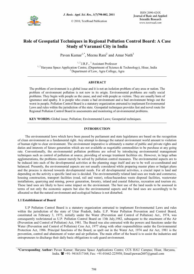
The following are major composition of the board which is shown in Figure 1.
Figure 1: Composition of board
Figure 2: Location of study area
1-3 Power of Board
1. To obtain information: On construction, installation or disposal system if it has any relevance to prevention or
control of pollution [U/S 20]. 2. Carry out any related work: If any industry fails to take up the same despite giving specific time bound notice
by state Board, for execution of such work any expenses incurred along with interest may be recovered from such person or industry as arrears of land revenue [U/S 30].
3. Collect and analyze samples of streams / wells or trade effluent : in case of trade effluent, in order to have legal validity, person taking sample should give notice in prescribed form, divide the sample in two parts and seal if request made by industry in this behalf. One part of sample is sent to lab recognized by State Pollution Control Board U/S 17 (2) and second part on request and at the cost of occupier to the State Lab notified U/s 52 of the Act.
4. To give direction: State Board has power to give directions to any person/officer or authority, which will be bound to comply with the directions. The direction may include direction for closure/prohibition or regulation of any industry operation or process or stoppage/regulation of services like electricity, water etc. The direction should be in writing and shall be (except under cases of grave injury to environment) followed by opportunity of being heard through a show cause notice U/S 33- A.
MATERIALS AND METHODS
2.1 Study Area
The ancient city of Varanasi was not built in a day. The city has two remnants of a holy past: the first being
Rajghat plateau, where the archeological findings of wares date back to the period of very existence of urban settlement and the second being Sarnath, where Buddha gave his first sermon, “Turning the wheel of law” in 528 BC. Varanasi town lies between the 25°15' to 25°22’ North latitude and 82°52’ to 81°01’ East longitude (Figure 2).The River Ganga only here flows south to North having the world famous ghats on the left bank of River. Varanasi is connected by road, rail and air with other part of country. A ridge runs almost 200 m. to 400 m. away from the western bank of Ganga and the area between the river and the ridge slopes towards the river Ganga. With vast expanse of gently undulating plain, most of the area beyond the ridge slopes towards the river Assi in the south and towards Varuna River in the north. The climate of the town is of tropical nature with temperature varying from 5°C
799
Kumar et al., 2011
in winter to 45°C in summer. The annual rainfall varies from 680 mm. to 1500 mm. with large proportion of its occurring during the months of July to September. 2.2 Data Used
For the study, LANDSAT satellite images of study area were acquired of 2002. These were obtained from Global Land Cover Facility (GLCF) an Earth Science Data Interface during analysis are given in Table 1.
Table 1: Description of satellite used data
Particulates
Satellite LANDSAT
Sensor ETM+
Band combination 4, 3, 2
Spatial Resolution 30, 60 &15 m.
Year 2002
2.3 Data Analysis
The spatial data consisting of Survey of India toposheet and satellite imagery were used after pre-processing. Various digital image-processing techniques to obtain valuable information related to study and also to identify the classes and feature. Digital image analysis was carried out using ERDAS-9.1 and ARC GIS 9.0 software package. All the spatial data in the form of map were scanned using scanner and transformed into computer readable digital maps. These digital maps were imported into PCI Geomatica and after performing optimum enhancement imported into ERDAS IMAGINE for further analysis. Based on the brief reconnaissance survey with additional information from previous research in the study area, a classification scheme was developed for the study area [1]. 2.4 Sites Selection
The sites can choose by Regional Pollution Control Board for water polluted, air polluted and noise polluted area of different places in Varanasi city. These are the important area of Varanasi and the problem of pollution is prevalent at these points. Our study was based on observing some factor related to health, pollution and impact on daily life pattern. 2.5 Classification scheme
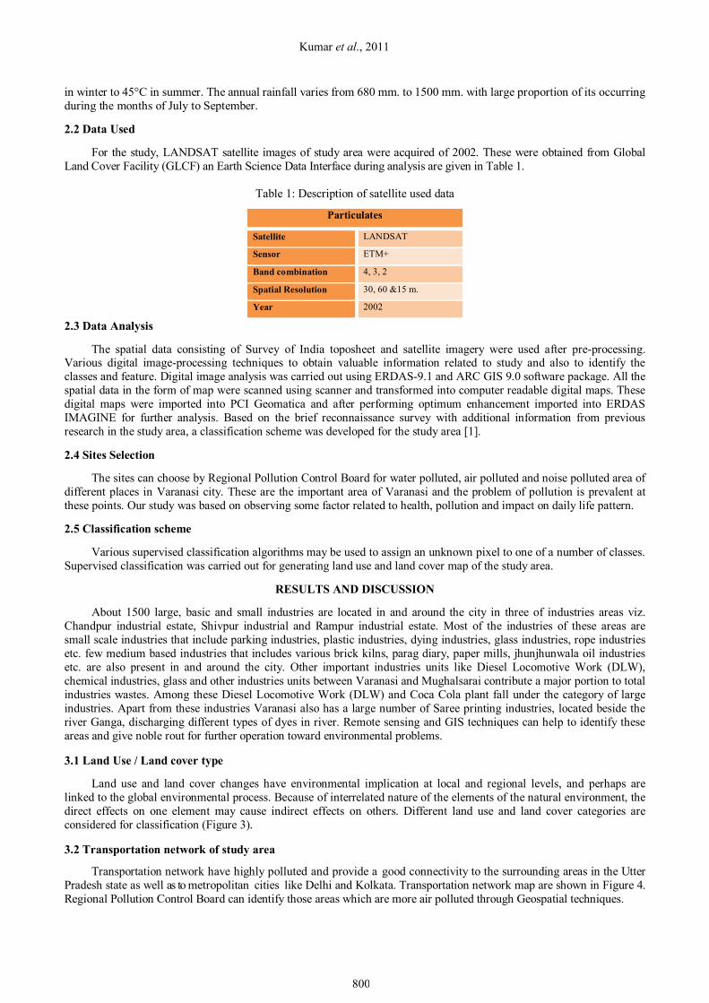
Various supervised classification algorithms may be used to assign an unknown pixel to one of a number of classes. Supervised classification was carried out for generating land use and land cover map of the study area.
RESULTS AND DISCUSSION
About 1500 large, basic and small industries are located in and around the city in three of industries areas viz. Chandpur industrial estate, Shivpur industrial and Rampur industrial estate. Most of the industries of these areas are small scale industries that include parking industries, plastic industries, dying industries, glass industries, rope industries etc. few medium based industries that includes various brick kilns, parag diary, paper mills, jhunjhunwala oil industries etc. are also present in and around the city. Other important industries units like Diesel Locomotive Work (DLW), chemical industries, glass and other industries units between Varanasi and Mughalsarai contribute a major portion to total industries wastes. Among these Diesel Locomotive Work (DLW) and Coca Cola plant fall under the category of large industries. Apart from these industries Varanasi also has a large number of Saree printing industries, located beside the river Ganga, discharging different types of dyes in river. Remote sensing and GIS techniques can help to identify these areas and give noble rout for further operation toward environmental problems. 3.1 Land Use / Land cover type
Land use and land cover changes have environmental implication at local and regional levels, and perhaps are linked to the global environmental process. Because of interrelated nature of the elements of the natural environment, the direct effects on one element may cause indirect effects on others. Different land use and land cover categories are considered for classification (Figure 3). 3.2 Transportation network of study area
Transportation network have highly polluted and provide a good connectivity to the surrounding areas in the Utter Pradesh state as well as to metropolitan cities like Delhi and Kolkata. Transportation network map are shown in Figure 4. Regional Pollution Control Board can identify those areas which are more air polluted through Geospatial techniques.
800
J. Basic. Appl. Sci. Res., 1(7)798-802, 2011
3.3 Scenario of water pollution
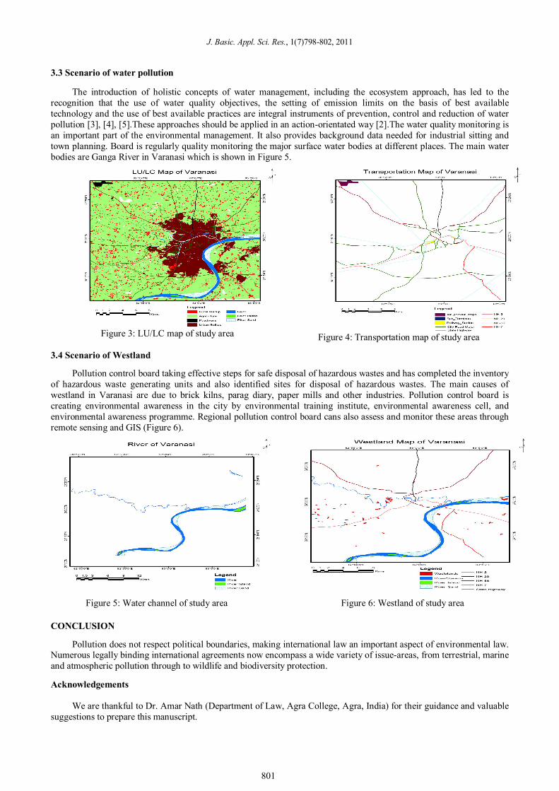
The introduction of holistic concepts of water management, including the ecosystem approach, has led to the recognition that the use of water quality objectives, the setting of emission limits on the basis of best available technology and the use of best available practices are integral instruments of prevention, control and reduction of water pollution [3], [4], [5].These approaches should be applied in an action-orientated way [2].The water quality monitoring is an important part of the environmental management. It also provides background data needed for industrial sitting and town planning. Board is regularly quality monitoring the major surface water bodies at different places. The main water bodies are Ganga River in Varanasi which is shown in Figure 5.
Figure 3: LU/LC map of study area
Figure 4: Transportation map of study area
3.4 Scenario of Westland
Pollution control board taking effective steps for safe disposal of hazardous wastes and has completed the inventory of hazardous waste generating units and also identified sites for disposal of hazardous wastes. The main causes of westland in Varanasi are due to brick kilns, parag diary, paper mills and other industries. Pollution control board is creating environmental awareness in the city by environmental training institute, environmental awareness cell, and environmental awareness programme. Regional pollution control board cans also assess and monitor these areas through remote sensing and GIS (Figure 6).
Figure 5: Water channel of study area
Figure 6: Westland of study area
CONCLUSION
Pollution does not respect political boundaries, making international law an important aspect of environmental law. Numerous legally binding international agreements now encompass a wide variety of issue-areas, from terrestrial, marine and atmospheric pollution through to wildlife and biodiversity protection. Acknowledgements
We are thankful to Dr. Amar Nath (Department of Law, Agra College, Agra, India) for their guidance and valuable
suggestions to prepare this manuscript.
801
Kumar et al., 2011
REFERENCES
1. Anderson et al., 1976. A Land Use and Land Cover classification system for use with remote sensor data.
Geological Survey Professional Paper No. 964, U.S. Government Printing Office, Washington, D.C., pp. 28.
2. Enderlein, R.E., 1995. Protecting Europe's water resources: policy issues. Wat. Sci. Tech., 31(8):1-8.
3. ICWE, 1992. The Dublin Statement and Report of the Conference, Development Issues for the 21st Century. International Conference on Water and the Environment: Dublin, Ireland.
4. UNCED, 1992. Agenda 21, Protection of the Quality and Supply of Freshwater Resources: Application of Integrated Approaches to the Development, Management and Use of Water Resources. United Nations Conference on Environment and Development, Rio de Janeiro, 14 June 1992:Chapter 18.
5. UNECE, 1993. Protection of Water Resources and Aquatic Ecosystems. Water Series, No. 1. ECE/ENVWA/31, United Nations Economic Commission for Europe, United Nations, New York..
802