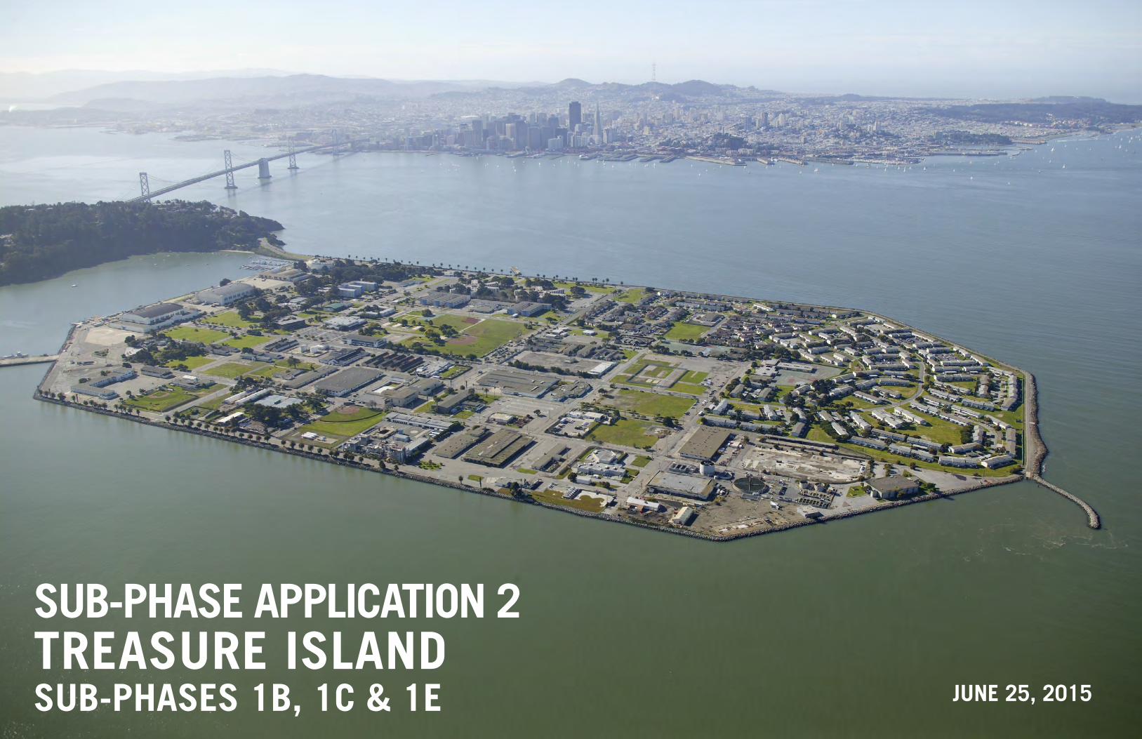
sub-phase application 2 treasure island
TRANSCRIPT

1B1C1E
JUNE 25, 2015
SUB-PHASE APPLICATION 2 TREASURE ISLANDSUB-PHASES 1B, 1C & 1E

PREPARED FOR TREASURE ISLAND DEVELOPMENT AUTHORITY
ONE AVENUE OF PALMS, SUITE 241
SAN FRANCISCO, CA 94130
SUBMITTED BY
PREPARED BY
JUNE 25, 2015
SUB-PHASE APPLICATION 2 TREASURE ISLANDSUB-PHASES 1B, 1C & 1E

SUB-PHASE APPLICATION 2: SUB-PHASES 1B, 1C & 1E4

THE FOLLOWING WERE INSTRUMENTAL IN THE PREPARATION OF THIS DOCUMENT
ACKNOWLEDGMENT
DESIGN TEAM CONT’DA. DESIGN TEAM
Conger Moss Guillard Landscape Architecture – Landscape Architecture/Urban DesignBKF Engineers – Civil EngineeringAGS – Civil EngineeringENGEO, Inc. – Geotechnical EngineeringMoffatt & Nichol – Shoreline EngineeringAECOM – Landscape ArchitectureHood Design – Landscape ArchitectureThe Office of Cheryl Barton – Landscape ArchitectureAndrea Cochran Landscape Architecture – Landscape ArchitectureBCV Architects – ArchitectureDilworth Eliot Studios – ArchitectureHorton Lees Brogden Lighting Design - Lighting DesignBarrie D. Coate and Associates – Arborist and HorticulturistMJM Management – Public Space Operations, Maintenance and ProgrammingPage & Turnbull – Historic Resource ConsultingZimmer Gunsul Frasca Architects LLP – Urban DesignHunt Design – Signage DesignFehr & Peers – Transportation DesignAlfaTech-Timmons – Electrical EngineeringEnvironmental Science Associates (ESA) – Archaeologist Holmes Culley – Structural EngineeringRaimi + Associates, Inc. – LEED ND ConsultantNelson Nygaard – Transportation ConsultantsGroundworks – Landscape ArchitectureMerril Morris -– Landscape ArchitectureBrookwater – Irrigation EngineeringSilverman and Light – Lighting DesignTownsend Management – Cost EstimatingWare Associates - ArchitectureRuss Mitchell Associates – Irrigation Wallace Labs – Soils Engineer
C. PROJECT MASTER DEVELOPER
Treasure Island Community Development LLC (TICD)
B. REVIEW AGENCIES
Treasure Island Development Authority (TIDA)Treasure Island/Yerba Buena Island Citizen Advisory Board (CAB)San Francisco Department of Public Works (DPW)San Francisco Public Utilities Commission (SFPUC)San Francisco Planning DepartmentSan Francisco Fire Department (SFFD)San Francisco Mayor’s Office of Disability/Disability Council (MOD)San Francisco Municipal Transportation Agency (SFMTA)San Francisco County Transportation Authority (SFCTA)Treasure Island Mobility Management Agency (TIMMA)
AEW – Environmental ConsultingTerra Engineering – Geotechnical EngineeringStructus – Structural EngineeringCM Pros – Cost EstimatingInfra Terra – Geotechnical EngineeringPacific Eco Risk – Environmental ConsultingArup North America – Structural EngineeringBrookwater – Irrigation DesignSBCA Tree Consulting - Arborist
5PREFACE

SUB-PHASE APPLICATION 2: SUB-PHASES 1B, 1C & 1E6

CONTENTS
2.0 LAND USE AND DEVELOPMENT PROGRAM
2.1 Overall Land Use
2.2 Sub-Phase Land Use
2.3 Sub-Phase Housing
2.4 Sub-Phase Retail Plan
2.5 Sub-Phase Development Blocks and
Mid-Block Easements
2.6 Sub-Phase Building Heights and Massing
2.7 LEED-ND Credit Checklist
30
31
32
35
36
39
47
29
1.0 INTRODUCTION
1.1 Regulatory Context and Authority
1.2 Project Overview, Phasing and Major Phase Overview
1.3 Sub-Phase Overview
1.4 Schedule of Performance
1.5 Associated Public Benefits
1.6 Consistency with Entitlement Documents
18
20
22
23
24
27
17
3.0 TRANSPORTATION AND STREETSCAPES
3.1 Streets Overview
3.2 Transportation Networks
3.2.1 Pedestrian Network
3.2.2 Bicycle Network
3.2.3 Vehicular Network
3.2.4 Transit Network
3.2.5 Trust Streets
3.3 Street Design
3.4 Parking and Loading
50
51
52
53
54
55
56
57
64
49 5.0 UTILITIES
5.1 Stormwater Treatment
5.2 Storm Drain
5.3 Sanitary Sewer
5.4 Low Pressure Water
5.5 Recycled Water
5.6 Supplemental Fire Water System
5.7 Joint Trench
5.8 Existing Soils and Geotechnical Mitigations
107
108
110
112
114
117
118
120
105
4.0 PARKS AND OPEN SPACE
4.1 Overall Parks and Open Space
4.2 Sub-Phase Parks and Open Space
4.2.1 Waterfront Plaza
4.2.2 Ferry Terminal
4.2.3 Ferry Shelter
4.2.4 Building 1 Plaza
4.2.5 Marina Plaza
4.2.6 Clipper Cove Promenade
4.2.7 Cultural Park
4.2.8 Cityside Waterfront Park
70
73
74
78
80
84
88
92
96
100
69
0.0 EXECUTIVE SUMMARY 13
6.0 APPENDICES
124
130
131
132
133
140
142
143
144
145
146
147
148
123
6.1 Appendix A: Sub-Phase MMRP
6.2 Appendix B: Schedule of Performance
6.3 Appendix C: Sub-Phase Housing Data Tables
6.4 Appendix D: Sub-Phase Cost Estimates
6.5 Appendix E: Corporate Guaranty
6.6 Appendix F: 50% Infrastructure Improvement Plans
6.7 Appendix G: Preliminary Stormwater Control Plan
6.8 Appendix H: 100% DD Parks and Open Space
6.9 Appendix I: Tentative Transfer Map
6.10 Appendix J: Draft Tentative Subdivision Map
6.11 Appendix K: Preliminary Utility Relocation Plans
6.12 Appendix L: Geotechnical Reports
6.13 Appendix M: Shoreline Improvement Plans
7PREFACE

1.0 INTRODUCTION
1.1 Overall Illustrative Plan
1.2 Major Phase Site Plan
1.3 Sub-Phase Application 2 Site Plan
1.4 Sub-Phase Public Benefits
16
21
22
25
4.0 PARKS AND OPEN SPACE
85
86
87
89
90
91
93
94
95
97
98
99
100
101
103
2.0 LAND USE AND DEVELOPMENT BLOCKS
2.1 Overall Proposed Land Use
2.2 Sub-Phase Land Use
2.3 Sub-Phase Authority Lots
2.4 Sub-Phase Auction Lots and JV Lots
2.5 Sub-Phase Retail Plan
2.6 Sub-Phase Development Blocks
2.7 Cityside Typical Block Plan
2.8 B1 Demonstrative Block Plan
2.9 Sub-Phase Building Heights and Massing
2.10 Sub-Phase Heights Requiring Consultation
2.11 Shared Public Way Stepback Example
2.12 Maximum Height for Allowable Building Zone
2.13 Bulk Reduction Strategies
2.14 Sub-Phase Conceptual Building Height and Massing
2.15 Maximum Plan Dimension and Maximum Apparent Face
2.16 Bulk and Massing Controls Matrix
2.17 Sub-Phase Streetwall Requirements
2.18 Streetwall Calculation Example
2.19 An Example of Minor Variations in a Streetwall
2.20 Shared Public Way Streetwall Example
2.21 Cityside Tower Stepback
2.22 Cityside Tower Parcel Streetwall Example
2.23 Shared Public Way Streetwall Example
2.24 Shared Public Way Stepback Above 40 feet
2.25 An Example of Streetwall Along Easements
2.26 Sub-Phase Streetwall Requirements
2.27 LEED-ND Credit Checklist
30
31
33
33
35
36
37
37
39
40
41
41
41
42
43
43
44
44
44
45
45
45
45
45
45
46
47
3.0 TRANSPORTATION AND STREETSCAPES
3.1 Pedestrian Network Site Plan
3.2 Bicycle Network Site Plan
3.3 Vehicular Network Site Plan
3.4 Transit Network Site Plan
3.5 Tidelands Trust Site Plan
3.6 Sub-Phase Illustrative Plan
3.7 TI Causeway, Palm Drive and Clipper Cove Ave. Intersection
3.8 Palm Drive Crossing
3.9 California Avenue and Palm Drive Intersection
3.10 California Avenue and Avenue C Intersection
3.11 Avenue C and 4th Street Intersection
3.12 Shared Public Way and 5th Street Intersection
3.13 Sub-Phase On-Street Parking and Vehicular Entrances
3.14 Sub-Phase Loading Zones
3.15 Sub-Phase Accessible Parking Zones
3.16 Sub-Phase Bicycle Parking
52
53
54
55
56
57
58
59
60
61
62
63
64
66
66
67
LIST OF FIGURES4.13 Building 1 Plaza Illustrative Plan
4.14 Building 1 Plaza Entrance View
4.15 Building 1 Plaza View
4.16 Marina Plaza Illustrative Plan
4.17 Marina Plaza Seating Area
4.18 Marina Plaza South Bird’s Eye View
4.19 Clipper Cove Promenade Illustrative Plan
4.20 Clipper Cove Promenade View From Avenue C
4.21 Clipper Cove Promenade View Towards the West
4.22 Cultural Park Illustrative Plan
4.23 Cultural Park Bird’s Eye View
4.24 Cultural Park View from Public Walk
4.25 Cityside Waterfront Park Illustrative Plan
4.26 Cityside Waterfront Park Sub-Phase Illustrative Plan
4.27 Cityside Waterfront Park view towards Bay Bridge
71
72
75
76
77
79
81
82
82
83
83
83
4.1 Open Space and Park Typologies
4.2 Sub-Phase Proposed Parks and Open Space
4.3 Waterfront Plaza Illustrative Plan
4.4 Waterfront Plaza Seating Cubes View
4.5 Waterfront Plaza Bird’s Eye View
4.6 Ferry Terminal Bird’s Eye View
4.7 Ferry Shelter Illustrative Floor Plan
4.8 Ferry Terminal Bird’s Eye View
4.9 Ferry Terminal Arrival View
4.10 Ferry Terminal Section at Windscreen
4.11 Ferry Terminal View from Crosswalk
4.12 Ferry Terminal View from Plaza
5.0 UTILITIES
5.1 Sub-Phase Stormwater Treatment
5.2 Sub-Phase Storm Drain
5.3 Sub-Phase Sanitary Sewer
5.4 Sub-Phase Low Pressure Water
5.5 Sub-Phase Recycled Water
5.6 Sub-Phase Supplemental Fire Water System
5.7 Sub-Phase Joint Trench
5.8 Sub-Phase Premilimary Mitigation Plan
107
109
111
113
115
117
119
121
SUB-PHASE APPLICATION 2: SUB-PHASES 1B, 1C & 1E8

4.0 PARKS AND OPEN SPACE
2.0 LAND USE AND DEVELOPMENT PROGRAM
2.1 TI Sub-Phases Aggregate Development in Relation to the Major Phase and the Total Allowable
Building Program
2.2 TI Sub-Phases Program of Uses and Approximate Square Footage of Each Use by Lot
2.3 TI Sub-Phase Summary of Proposed Housing Data
2.4 Proposed Schedule for the Excess Land Appreciation Structure
2.5 Sub-Phase Development Lots Square Footage
30
31
32
33
36
3.0 TRANSPORTATION AND STREETSCAPES
3.1 Sub-Phase Anticipated On-Street Parking Allocation
3.2 Sub-Phase Anticipated Off-Street Parking Allocation
64
65
LIST OF TABLES
4.1 TI Sub-Phase Parks and Open Space Acreage 72
1.0 INTRODUCTION
1.1 Treasure Island Performance Milestones for Sub-Phase Application 1 23
9PREFACE

SUB-PHASE APPLICATION 2: SUB-PHASES 1B, 1C & 1E10

A
AC acres
AC Alameda-Contra Costa (Transit)
ADA Americans with Disabilities Act
AT&T American Telephone & Telegraph
B
BFE Base Flood Elevation
CD Construction Documents
BMP Best Management Practices
BLDG Building
C
CAB Citizen Advisory Board
CEQA California Environmental Quality Act
CIP cast-in-place
D
D4D Design for Development
DA Development Agreement
DD Design Development
DDA Disposition and Development Agreement
DRDAP Design Review and Document Approval Procedure
E
(E) Existing
EBMUD East Bay Municipal Utility District
EIR Environmental Impact Report
GLOSSARY OF ABBREVIATIONS AND ACRONYMS
F
FPS feet per second
G
GGIE Golden Gate International Exposition
GSF gross square fee
H
HMP Habitat Management Plan
I
ICA Interagency Cooperation Agreement
IP Infrastructure Plan
IPCC Intergovernmental Panel on Climate Change
J
JV Joint Venture
L
LED light-emitting diode
LEED-ND Leadership in Energy & Environmental Design
Neighborhood Development
LPW low pressure water
M
MHW Mean High Water
MLLW Mean Lower Low Water
MMRP Mitigation and Monitoring and Reporting Program
MUP Master Utility Plans
MP Major Phase
N
NAVD North American Vertical Datum of 1988
NAVD88 North American Vertical Datum of 1988
NRC National Research Council
NSTI Naval Station Treasure Island
O
O+M Operations and Maintenance
P
PG&E Pacific Gas and Electric
PV photovoltaic
POSP Parks and Open Space Plan
R
ROW Right of Way
RW recycled water
S
SBE Small Business Enterprise
SF MUNI San Francisco Municipal Transit
SFCTA San Francisco County Transportation Authority
SFFD San Francisco Fire Department
SFPUC San Francisco Public Utilities Commission
SFMTA San Francisco Municipal Transportation Agency
SGMP Soil and Groundwater Management Plan
SLC (California) State Lands Commission
SLR Sea Level Rise
SOQHD Senior Officer Quarters Headquarters District
SP spaces (parking)
SS sanitary sewer
SWPPP Stormwater Pollution Prevention Plan
T
TI Treasure Island
TICD Treasure Island Community Development
TIDA Treasure Island Development Authority
TIHDI Treasure Island Homeless Development Initiative
TIMMA Treasure Island Mobility Management Agency
TITIP Treasure Island Transportation Implementation Plan
TSM Tentative Subdivision Map
TTM Tentative Transfer Map
U
US United States
W
WRU Wave Run-Up
Y
YBI Yerba Buena Island
YMCA Young Men’s Christian Association
11PREFACE

4A4C
4B4D
4E
3B
3C
3A
2B
2A
2C
1A
1B1C
1D
1E
1F
1YA
1YB
Major Phase 1 Boundary
1000’ 2000’
N
MAJOR PHASES
Major Phase 2
Major Phase 4 Major Phase 3
Major Phase 1
MAJOR PHASE SITE PLAN
Sub-Phase Boundary
SUB-PHASE APPLICATION 2: SUB-PHASES 1B, 1C & 1E12

EXECUTIVE SUMMARYThe site for the Treasure Island and Yerba Buena Island “Project” is divided into four “Major Phases” (large, mixed-use areas) and, within each Major Phase, various “Sub-Phases” (one or more adjacent blocks within the Major Phase). This is conceptually illustrated in the Major Phases diagram on the previous page.
Subject to the terms and conditions in the Project’s Disposition and Development Agreement (DDA), Treasure Island Development Authority (TIDA) will convey portions of the Project Site owned or acquired by TIDA to the Developer, Treasure Island Community Development (TICD), for phased development by TICD.
This application is the presentation by TICD of additional detailed information for Sub-Phases 1B, 1C, and 1E. It includes all of the plans, diagrams, data, narrative, reports, and compliance updates that are set forth in the Project’s Design Review and Document Approval Procedure (DRDAP) exhibit to the DDA.
The Sub-Phase Application 1: Sub-Phases 1B, 1C, and 1E is organized according to the following Chapters.
1.0 INTRODUCTION
The Introduction chapter provides summary project background information including the regulatory governing processes for the Project, an overview of Sub-Phases 1B, 1C, and 1E, confirmation of the Sub-Phase compliance with the Schedule of Performance and other entitlement documents, and a description of the Sub-Phase Associated Public Benefits.
2.0 LAND USE AND DEVELOPMENT BLOCKS
The Land Use and Development Program chapter describes proposed Sub-Phase land uses. The proposed land uses and building design standards are consistent with descriptions provided in previously approved Project documents.
The chapter also confirms proposed locations for the various types of residential lots and commercial areas. Information about development blocks, easement standards, building heights and massing, and setbacks and streetwalls are also included in this chapter, along with information about the retail plan.
3.0 TRANSPORTATION AND STREETSCAPES
The Transportation and Streetscapes chapter describes the various transportation networks planned for Sub-Phases 1B, 1C, and 1E, including pedestrian, bicycle, vehicular, and transit. Information about street design and street intersections is included in the section, along with on-street and off-street parking locations, accessible loading and parking, and bicycle parking.
4.0 PARKS AND OPEN SPACE
The Parks and Open Space chapter includes 100% Design Development renderings, plans, illustrative images, and design narrative for all of the Open Space Lots within Sub-Phases 1B, 1C, and 1E. Design updates from the Schematic Design materials presented in the Major Phase 1 Application are provided for Waterfront Plaza, Ferry Terminal (land side and water side), Building 1 Plaza, Marina Plaza, Clipper Cove Promenade, Cultural Park, and Cityside Waterfront Park.
5.0 UTILITIES
The Utilities chapter features narratives, plans and 50% Construction Documents for each of the major utility systems in the Project, including storm water treatment, storm drainage, sanitary sewer, low pressure water, recycled water, and the joint trench (dry utilities: electric, gas, telephone, and cable TV). The information provided in this chapter is consistent with information in Project-wide utility master plans for each system. 50% Construction Documents for for Sub-Phase utilities are in Appendix F.
6.0 APPENDICES
Various appendices in this chapter provide greater level of data and technical detail in support of the Sub-Phase application.
The bulk of the sub-phase design can be found in the 50% Infrastructure Improvement Plans, which include all the improvements in the public right of way, and the 100% of Design Development (DD) package for open spaces. Other appendices include a compliance report for the Project EIR mitigation measures, the current Schedule of Performance, updated Housing Data Tables, cost estimates for Infrastructure, a form of Corporate Guaranty for Sub-Phase Improvements and Preliminary Stormwater Control Plan. Several appendices have been included for information only and are available on the enclosed disc with this document. Those include subdivision maps, preliminary utility relocation plans, geotechnical reports, and shoreline improvement plans.
13PREFACE / EXECUTIVE SUMMARY

SUMMARY OF APPENDICES6.1 APPENDIX A: MITIGATION MONITORING AND REPORTING PROGRAM (MMRP)
The MMRP was established to provide for the monitoring of mitigation measures required of the Project, as set forth in the Final EIR. Prior to the issuance of building permits, while detailed development plans are being prepared for approval by TIDA and/or City staff, Treasure Island Development Authority (TIDA) and/or City staff will be responsible for ensuring compliance with mitigation monitoring applicable to the Project construction, development and design phases. The status of all applicable mitigation measures is included in Appendix A.
6.2 APPENDIX B: SCHEDULE OF PERFORMANCE
The Disposition and Development Agreement (DDA) contemplates that the submission of Major Phase and Sub-Phase Applications, the Commencement and Completion of Infrastructure and Stormwater Management Controls within Sub-Phases, the Commencement and Completion of the Required Improvements and certain other major milestones will be commenced or completed by the specific dates in the Schedule of Performance included in the DDA as Exhibit JJ. A revised Schedule of Performance was approved with the Major Phase 1 application on May 13, 2015, and it is attached herein as Appendix B, with no further revisions.
6.3 APPENDIX C: SUB-PHASE HOUSING DATA TABLES
In order to track compliance with the Project’s Housing Plan, each Sub-Phase Application includes a Housing Data Table that includes the location and acreage for each residential lot in those Sub-Phases, the percentage of acreage of Authority Housing Lots to the total housing in those Sub-Phases, the cumulative total of Authority Housing acreage to date, the cumulative number of Developer Residential Units in those Sub-Phases, and additional
information about each anticipated residential project in those Sub-Phases. When Sub-Phase property is conveyed to the Developer, TIDA retains the Authority Housing Lots within that sub-phase.
6.4 APPENDIX D: SUB-PHASE COST ESTIMATES
The Sub-Phase Cost Estimate identifies the estimated cost of completion for the improvements in Sub-Phases 1B, 1C, and 1E. Upon approval of the Sub-Phase application by TIDA Executive Director, this estimated cost of completion is the Sub-Phase Construction Secured Amount for which the Developer will provide Adequate Security (refer to Appendix E: Corporate Guaranty). 6.5 APPENDIX E: CORPORATE GUARANTY
The Developer must provide a Guaranty to secure its obligations for each Sub-Phase no later than 30 days after approval of that Sub-Phase, the proposed form of which is included herein. For this Sub-Phase Application 2, the Developer proposes to provide a Corporate Guaranty equal to 125% of the cost of completion of the obligations. Prior to acceptance of TICD’s Corporate Guaranty, TICD will assign its SP2 interests in the DDA to Treasure Island Series 1, LLC, who will execute the obligations and serve as the Developer for the Guaranty. Treasure Island Series 1, LLC is a wholly owned subsidiary of TICD
6.6 APPENDIX F: 50% INFRASTRUCTURE IMPROVEMENT PLANS
The Sub-Phase Application includes 50% Improvement Plans for all utilities, along with a plan or narrative that indicates the relationship of those Sub-Phases to their Major Phase and to the utilities serving the entire Project, including sanitary sewer and storm drain facilities, low pressure, high pressure, and reclaimed
SUB-PHASE APPLICATION 2: SUB-PHASES 1B, 1C & 1E14

water facilities, and joint trench for electric power, natural gas, telephone and data communications. The Developer plans to submit 95% complete Infrastructure Plans for agency review in late October 2015, for DPW’s issuance of construction permits.
6.7 APPENDIX G: PRELIMINARY STORMWATER CONTROL PLAN
The Preliminary Stormwater Control Plan for Sub-Phase Application 2 describes the proposed stormwater system, which includes a “treatment train” strategy in urban park settings for the Sub-Phases’ larger centralized treatment areas and other stormwater treatment types for the smaller drainage management areas. The Preliminary Stormwater Control Plan identifies all drainage management areas with Best Management Practices (BMPs) for each, area summary tables, BMP sizing calculations, and typical details for each BMP type. The Developer plans to submit the Final Stormwater Control Plan, including 5-Year Conveyance System (SWMM) and 100-Year Overland Flow Conveyance Models, with the 95% complete Infrastructure Plans in late October 2015, for PUC’s approval.
6.8 APPENDIX H: 100% DD PARKS AND OPEN SPACE
The Sub-Phase Application includes 100% Design Development drawings for the Open Space Lots within the Sub-Phase areas, including landscape architectural plans and sections that fix the location and design of landscape elements, outline specifications, and material and color information. The Developer plans to submit the 100% Construction Documents for the Open Space Lots in late October 2015, for approval by TIDA Executive Director.
6.9 APPENDIX I: TENTATIVE TRANSFER MAP
Prior to conveyance of the Sub-Phase Lots from the Authority to the Developer, the City will approve and the Authority will record a Transfer Map for the applicable property, which is in
compliance with the California Subdivision Map Act. A Tentative Transfer Map is included in this Sub-Phase Application 2. Following approval of the Tentative Transfer Map by the DPW Director and prior to the conveyance of property to the Developer, the Developer will submit Final Transfer Maps for approval by the San Francisco Board of Supervisors.
6.10 APPENDIX J: DRAFT TENTATIVE SUBDIVISION MAP
Prior to conveyance of the Sub-Phase Lots from the Authority to the Developer, the Developer will procure approval of the Tentative Subdivision Map, which is in compliance with the California Subdivision Map Act. A Tentative Subdivision Map is included in this Sub-Phase Application 2. Following approval of the Tentative Subdivision Map by the DPW Director and prior to the subdivision of parcels by the (Master) Developer for sale of development lots to Vertical Developers, the Developer will submit Phased Final Subdivision Maps for approval by the San Francisco Board of Supervisors.
6.11 APPENDIX K: PRELIMINARY UTILITY RELOCATION PLANS (FOR INFORMATION ONLY)
Before commencing construction of improvements and to ensure minimal interruption of utility services to remaining existing operations on Treasure Island and Yerba Buena Island, existing buildings in the Sub-Phase area that are scheduled for removal must be demolished and existing utilities must be moved out of the way. Preliminary demolition and utility relocation plans are included in this Sub-Phase Application for information only. The Developer plans to submit the Demolition and Utility Relocation Plans in late July 2015, for approval by TIDA Executive Director.
6.12 APPENDIX L: GEOTECHNICAL REPORTS (FOR INFORMATION ONLY)
Geotechnical reports for this Sub-Phase area that were developed subsequent to the submission of the Major Phase 1 Application are included in this Sub-Phase Application for information and include data report, characterization report, supplemental basis of design memorandum, and design report. The Draft Geotechnical Report for Sub-Phases 1B, 1C, and 1E was issued to DPW and DBI for their review and approval on April 21, 2015.
6.13 APPENDIX M: PRELIMINARY SHORELINE IMPROVEMENT PLANS (FOR INFORMATION ONLY)
The existing rock slope shoreline protection along the perimeter of Treasure Island will be augmented with additional rock and receive geotechnical stabilization improvements. Preliminary shoreline improvement plans are included in this Sub-Phase Application for information only. The Developer plans to submit the 100% Shoreline Improvement Plans in late October 2015, for approval by TIDA Executive Director.
15PREFACE / EXECUTIVE SUMMARY

1 - INTRODUCTION 16SUB-PHASE APPLICATION 2: SUB-PHASES 1B, 1C & 1E
YERBA BUENA ISLAND
TREASURE ISLAND
FIGURE 1.1 OVERALL ILLUSTRATIVE PLAN

1 - INTRODUCTION 17SUB-PHASE APPLICATION 2: SUB-PHASES 1B, 1C & 1E
1. INTRODUCTION1.1
1.2
1.5
1.4
1.6
1.3
18
20
24
23
27
22
REGULATORY CONTEXT AND AUTHORITY
PROJECT OVERVIEW, PHASING AND MAJOR PHASE OVERVIEW
ASSOCIATED PUBLIC BENEFITS
SCHEDULE OF PERFORMANCE
CONSISTENCY WITH ENTITLEMENT DOCUMENTS
SUB-PHASE OVERVIEW

1.1 REGULATORY CONTEXT AND AUTHORITYThe General Plan land use designations and policies governing Treasure Island and Yerba Buena Island are set forth in the Treasure Island / Yerba Buena Area Plan, an area plan of the City’s General Plan that provides the broad General Plan objectives and policies to redevelop the islands. The overall objectives and policies of the General Plan are implemented through the applicable zoning for the islands, which is found in the Treasure Island / Yerba Buena Island Special Use District (“Special Use District”), Section 249.52 of the Planning Code. The Special Use District includes basic land use and development standards for the development areas of Treasure Island and Yerba Buena Island identified in the Special Use District (“Development Plan Area”), and sets forth the process for approval by TIDA and the Planning Department and Commission, as applicable, of Vertical Improvements. The Special Use District references the Design for Development, also adopted by the Planning Commission, for more detailed design standards and guidelines for development.
TIDA is the public agency responsible for the oversight of the development within the Development Plan Area, and administers the property that is subject to the Tidelands Trust in accordance with the land use restrictions set forth in the Treasure Island Conversion Act of 1997 (amending Section 33492.5 of the California Health and Safety Code and added Section 2.1 to Chapter 1333 of the Statutes of 1968). TIDA will have oversight for the horizontal development of the islands as more particularly described in the Design for Development. TIDA, for the Tidelands Trust property, and the Planning Department and Commission, as applicable, will review and approve the development of buildings on the islands in accordance with the standards and procedures set forth in the Special Use District and the Design for Development.
As set forth in the Special Use District, the Special Use District and Design for Development supersede the San Francisco Planning Code in its entirety except as otherwise expressly noted in the Design for Development. The Green Building Specifications in the
Design for Development supplement the City and County of San Francisco’s Green Building Ordinance, essentially “raising the sustainability bar” for the islands’ development. In addition, all development on the islands is subject to contractual agreements with the Developer that include detailed infrastructure and transportation plans, as more particularly described in the Design for Development. In the event of any conflict between the Design for Development and the Special Use District, the Special Use District provisions control.
DESIGN REVIEW AND DOCUMENT APPROVAL PROCEDURE
The Design Review and Document Approval Procedure (DRDAP), which is part of the Treasure Island and Yerba Buena Island Disposition and Development Agreement (DDA), sets forth the procedures for submitting, reviewing, and approving Major Phase and Sub-Phase Applications for the Project Site. The review and approval process set forth in the DRDAP relates primarily to horizontal infrastructure development and compliance with various obligations under the DDA..
MAJOR PHASE APPLICATIONS AND APPROVALS
The purpose of a Major Phase Application is for the Developer -- Treasure Island Community Development (TICD) -- to present additional detailed information for a certain geographic area of the Treasure Island and Yerba Buena Island Project (Project), referred to as a Major Phase (see Figure 1.1). Major Phase Applications generally include overall site plans, vicinity plans, illustrative concept plans for Infrastructure and Stormwater Management Controls, including all Associated Public Benefits, and any proposed changes to the Phasing Plan attached to the DDA, as updated and approved from time to time.
The Treasure Island Development Authority (TIDA) shall review such Applications and coordinate with applicable City Agencies for review in accordance with the Interagency Cooperation Agreement (ICA). TIDA’s approval of the Major Phase confirms
that the Major Phase Application conforms to and is consistent with the applicable Development Requirements, and for the Developer to obtain approval by TIDA of the additional detailed information included in a Major Phase Application that has not been previously reviewed or approved by TIDA.
Under the DDA, the TIDA Board must approve the Major Phase Application before the TIDA Executive Director may approve a Sub-Phase.
SUB-PHASE APPLICATIONS AND APPROVALS
A Sub-Phase is a smaller geographic area within a Major Phase. A Sub-Phase Application includes plans for Infrastructure and Stormwater Management Controls within the Sub- Phase, including data charts, site plans, 50% Construction Documents for Infrastructure and Stormwater Management Controls within the Sub-Phase, and 100% Design Development Documents for Open Space Lots.
A Sub-Phase Application must be approved by the Executive Director before the conveyance of land to TICD, before building permits may be issued for Infrastructure and Stormwater Management Controls and before the Authority’s consideration of and grant of Vertical Approvals.
The Developer will submit Sub-Phase Applications for the Sub-Phases within Major Phase 1 in accordance with the Schedule of Performance (See Sections 1.4 and 1.6 of the approved Major Phase Application).
VERTICAL APPLICATIONS AND APPROVALS
The procedure for submitting, reviewing and approving applications for Vertical Improvements in the Project Site is governed by the Treasure Island and Yerba Buena Island Special Use District that resides in Section 249.52 of the City’s Planning Code.
SUB-PHASE APPLICATION 2: SUB-PHASES 1B, 1C & 1E 1 - INTRODUCTION 18

RELATIONSHIP OF THE SUB-PHASE APPLICATION TO OTHER PROJECT DOCUMENTS
The Disposition and Development Agreement (DDA) for Treasure Island and Yerba Buena Island were approved by the City of San Francisco in June 2011. The DDA and its attached Exhibits guide and regulate the implementation of the redevelopment project. The Major Phase 1 application was approved by Treasure Island Development Authority in May 2015. The following related documents are the most relevant to the information provided in this Sub-Phase Application.
Design for Development DocumentThe Design for Development for Treasure and Yerba Buena Islands (D4D)is the guiding document for the land use, urban design, vertical development and building design, streets and public parks and open spaces. It includes the overall vision for the project, the planning and transportation frameworks, land use, building massing and height controls, as well as programmatic requirements, standards and guidelines for the implementation of the streets, parks, and open spaces. It is the primary reference document relative to the design of the public realm and vertical development.
Treasure Island and Yerba Buena Island Parks and Open Space Plan The Parks and Open Space Plan was approved by the City in June of 2011 as part of the project entitlements and establishes the scope and program for park and open space improvements that are required as part of the project. The Open Space Plan is consistent with the standards and design guidelines established in the Design for Development and provide additional information regarding program, materials and furnishings, as well as maintenance and operations. The Plan is the primary reference for review of the Parks and Open Spaces in this Sub-Phase Application.
Streetscape Master PlanThe Streetscape Master Plan was approved by TIDA in February 2015 and further develops the streetscape design defined in the Design for Development. The master plan includes specific design
standards and guidelines that will direct the implementation of streetscapes on both islands. The master plan also positions the streetscape as an integral component of an innovative and welcoming public realm by establishing guidelines for paving, street trees, planting, lighting, furnishings, accessible parking and on-street loading as well as coordinating with necessary utilities. The document is the primary reference for review of the streetscape design in this Sub-Phase Application.
Treasure Island & Yerba Buena Island Signage Master Plan The Treasure Island & Yerba Buena Island Signage Master Plan (SMP) provides concept-level designs and locations for non-standard signs within the public right of way and in TIDA-owned parks and open spaces. The signage in the SMP falls into three general categories: identification, interpretation and wayfinding. Wayfinding – including vehicular, bicycle, and pedestrian – is the primary focus of the SMP because it requires a cohesive, project wide approach to be effective. Illustrative examples of identification and interpretive signage are provided in the SMP, however it is anticipated that these types of signs will be site-specific and will be designed with their environs.
Master Utility PlansThe Master Utility Plans further develop the Infrastructure Plan approved by the City as part of the entitlements in June 2011 and provide detailed design criteria and systematic layout for the construction of new infrastructure on both Treasure Island and Yerba Buena Island. The Master Utility Plans include; Grading and Storm Drain, Joint Trench, Low Pressure Water, Recycled Water, and Sanitary Sewer systems. Each has been coordinated with applicable City Departments and utility service providers.
Stormwater Control PlansStormwater Control Plans documenting the proposed storm water management and treatment measures are required by the SFPUC Stormwater Design Guidelines. A Preliminary Stormwater Control Plan is included with this Sub-Phase Application as Appendix H. It further specifies the size, type, and detailed design of storm water treatment systems and features. The design of storm water treatment systems and open spaces shall be coordinated to ensure aesthetic and programmatic consistency.
Yerba Buena Island Habitat Management Plan (YBI HMP)The YBI Habitat Management Plan approved by TIDA in April 2011 describes adaptive management strategies for the preservation, restoration, and enhancement of ecological resources and habitat on Yerba Buena Island. The goals and strategies outlined in the plan are an integral part of the YBI open space program.
Sustainability PlanThe Sustainability Plan finalized in June 2011 includes both sustainability commitments and aspirations. The Environmental Sustainability Obligations are part of the project entitlements. The obligations they describe in greater detail address Land Use, Transportation, Infrastructure, Energy and Water, Building Design and Construction, Solid Waste Management, and Community Benefits.
SUB-PHASE APPLICATION 2: SUB-PHASES 1B, 1C & 1E 1 - INTRODUCTION 19

1.2 PROJECT OVERVIEW, PHASING AND MAJOR PHASE OVERVIEWPROJECT OVERVIEW
Treasure Island and Yerba Buena Island are in the San Francisco Bay, about halfway between the San Francisco mainland and Oakland. The Islands are the site of the former Naval Station Treasure Island (NSTI), which is owned by the U.S. Navy. NSTI was closed on September 30, 1997, as part of the Base Realignment and Closure Program. The Islands also include a U.S. Coast Guard Station and Sector Facility, a U.S. Department of Labor Job Corps campus, and Federal Highway Administration land occupied by the San Francisco-Oakland Bay Bridge and tunnel structures.
The Project facilitates the City’s long-term goal of implementing the creation of a new City neighborhood on Treasure Island and Yerba Buena Island that provides extensive public benefits to the City such as significant amounts of new affordable housing, increased public access and open space, transportation improvements, extensive infrastructure improvements, and recreational and entertainment opportunities, while creating jobs and a vibrant, sustainable community. In particular, the Project provides an innovative transportation program designed to maximize transit usage and opportunities for walking and biking, with a dense mixed-use urban core in close proximity to transit, and provides a model for sustainable development. The Project provides for the creation of approximately 300-acres of public open spaces, including neighborhood parks, sports fields, shoreline parks, wetlands, and urban farm and large areas for passive recreation and native habitat.
The Treasure Island Development Authority (TIDA) proposes to redevelop NSTI, some portions of which have been transferred to TIDA adn other portions which are still owned by the Navy. The Development Plan will be carried out by Treasure Island Community Development, LLC (TICD), a private development entity who has the right to develop the Project Site in accordance
with the Development Agreement (DA) and the Disposition and Development Agreement (DDA), and related Project approvals (including the certified Environmental Impact Report (EIR), Design for Development (D4D), Parks and Open Space Plan (POSP), Streetscape Master Plan, Treasure Island Transportation Implementation Plan (TITIP), and Infrastructure Plan (IP)). These documents control the overall design, development and construction of the Project and all improvements, including the permitted uses on the Project Site, the density and intensity of uses, the maximum height and size of buildings, the number of allowable parking spaces and all Mitigation Measures required in order to eliminate or mitigate any materially adverse environmental impacts of the Project.
The development of the Project’s planning and design documents is a thorough, thoughtful, and collaborative process, and it has included the engagement of hundreds of members of the community and many public agencies. A series of public hearings and numerous workshops with regulatory agency representatives have led to the preparation of this Sub-Phase Application.
Currently, the former military base consists primarily of low-density residential uses, along with vacant and underutilized non-residential structures. There are about 1,005 total dwelling units on Treasure Island and Yerba Buena Island (of which about 726 are available for occupancy), about 100 buildings with existing and former non-residential uses, parking and roadways, open space, a wastewater treatment facility, and other infrastructure.
The Project provides a new, high-density, mixed-use community with a variety of housing types, a retail core, open space and recreation opportunities, on-site infrastructure, and public and community facilities and services. In all, there will be up to 8,000 residential units; up to 140,000 square feet (sq. ft.) of new commercial and retail space; approximately 100,000 sq. ft. of new office space; up to 500 hotel rooms; approximately 300
acres of parks and open space; bicycle, transit, and pedestrian facilities; a ferry terminal and intermodal transit hub; and new and/or upgraded public services and utilities, including a new or upgraded wastewater treatment plant.
Three historic buildings on Treasure Island would be adapted to house up to 311,000 sq. ft. of commercial space. There is an opportunity to adaptively reuse nine historic buildings and four garages on Yerba Buena Island. The Navy will remediate hazardous materials to standards consistent with applicable Federal laws governing base closure prior to transfer. Geotechnical improvements will be made to stabilize Treasure Island and the causeway that connects it to Yerba Buena Island. Build out will be implemented in phases, anticipated to occur from approximately 2016 through 2034, depending on market conditions.
The Project’s urban form is intended to be distinctive, place-based, and experience-focused, establishing a memorable identity on the Bay. Treasure Island is arranged with a series of fine-grained, walkable blocks. The new homes on Treasure Island will form two neighborhoods – one along the island’s western edge with spectacular views back to the City, and a second stretching to the east along Clipper Cove with views of the new Bay Bridge and the East Bay hills. Each neighborhood will feature a distinctive mix of parks, and both will be enveloped by a regional waterfront park system that will occupy the majority of land on the island. The east and west neighborhoods will have a retail main street linking the historic buildings along clipper cove to the west-facing ferry and bus facilities. On Yerba Buena Island, the rugged natural topography informs the placement and form of development, which is focused on views and relationship to natural habitats. Yerba Buena Island’s limited development footprint allows preservation of natural vegetation and landform along with historic structures and gardens.
SUB-PHASE APPLICATION 2: SUB-PHASES 1B, 1C & 1E 1 - INTRODUCTION 20
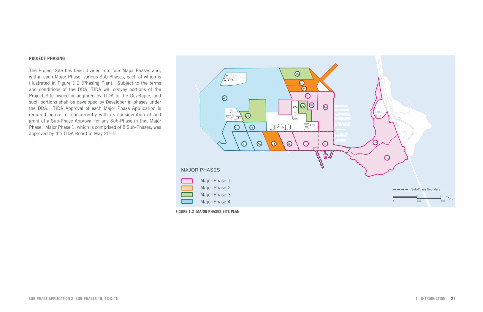
PROJECT PHASING
The Project Site has been divided into four Major Phases and, within each Major Phase, various Sub-Phases, each of which is illustrated in Figure 1.2 (Phasing Plan). Subject to the terms and conditions of the DDA, TIDA will convey portions of the Project Site owned or acquired by TIDA to the Developer, and such portions shall be developed by Developer in phases under the DDA. TIDA Approval of each Major Phase Application is required before, or concurrently with its consideration of and grant of a Sub-Phase Approval for any Sub-Phase in that Major Phase. Major Phase 1, which is comprised of 8 Sub-Phases, was approved by the TIDA Board in May 2015.
4A4C
4B4D
4E
3B
3C
3A
2B
2A
2C
1A
1B1C
1D
1E
1F
1YA
1YB
Major Phase 1 Boundary
1000’ 2000’
N
MAJOR PHASES
Major Phase 2
Major Phase 4 Major Phase 3
Major Phase 1
4A4C
4B4D
4E
3B
3C
3A
2B
2A
2C
1A
1B1C
1D
1E
1F
1YA
1YB
Major Phase 1 Boundary
1000’ 2000’
N
MAJOR PHASES
Major Phase 2
Major Phase 4 Major Phase 3
Major Phase 1
FIGURE 1.2 MAJOR PHASES SITE PLAN
Sub-Phase Boundary
SUB-PHASE APPLICATION 2: SUB-PHASES 1B, 1C & 1E 1 - INTRODUCTION 21

1.3 SUB-PHASE OVERVIEW
B1.1 B1.2C1.1 C1.2
B1.3
Y1.1
Y1.2
Y6
250’ 500’0’
N
Sub-Phase Boundary
1B1C1E
TI SUB-PHASES
Sub-Phase 1BSub-Phase 1CSub-Phase 1E
FIGURE 1.3 SUB-PHASE APPLICATION 2 SITE PLAN
This Sub-Phase Application comprises three Sub Phases on Treasure Island: 1B, 1C and 1E, as illustrated in Figure 1.3. Within these three Sub Phases are four new development blocks that form the core of two Island Districts described in the Design for Development:
• The Island Center will be a 24-hour district with a memorable skyline, an inviting network of lively spaces, a retail main street and plazas, marina and water access, and the density and intensity to support an intermodal transit center, the last of which is included within Sub-Phase 1B. • The Cityside district will include a diversity of housing types clustered around neighborhood parks and linked by a Shared Public Way with primary pedestrian and bicycle use and limited vehicular service.
A predominantly 3-6 story building fabric will be punctuated by mid-rise buildings along Avenue C, and neighborhood towers adjacent to neighborhood parks. A collection of east-west streets, neighborhood Windrow Streets and Mid-block Easements cross the Shared Public Way while passing through the Cityside District. This is intended to draw residents from within the neighborhood to the Cityside Waterfront Park, while attracting visitors into the Cityside District along wind-buffered, pedestrian- oriented routes. Sub Phase 1B consists of Block B1 which is formed around the historic Building 1. Commensurate with its gateway location and function, this block will be improved with landscaping on all sides of Building 1, with a two development lots on its eastern edge to connect to the Retail Main Street in adjacent block.
Sub Phase 1C consists of Blocks C.1 and C.2. The land uses in these 2 blocks consist of the Cultural Park around the existing Chapel, residential development lots, and a hotel development lot on Trust Land. Block C.2 is a prototype of most blocks that would
be developed in the Cityside district, bisected by Shared Public Ways and providing several lots for residential development.
Sub Phase 1E consists of Block C.3, programmed for primarily residential use. It is comprised of several development lots and is the first block in the Cityside District to have a neighborhood park fronting the Shared Public Way that would be provided on a private development lot.
SUB-PHASE APPLICATION 2: SUB-PHASES 1B, 1C & 1E 1 - INTRODUCTION 22

1.4 SCHEDULE OF PERFORMANCEAPPLICATION OUTSIDE DATES
The Schedule of Performance included in the DDA (as amended in Major Phase 1 application and included as Appendix B) provides for the submittal of the Sub-Phase Application as follows: • 2015 - Sub-Phase 1C • 2015 - Blocks C1 and C2 • 2015 - Cityside Waterfront Park 1 • 2015 - Cultural Park • 2016 - Sub-Phase 1B • 2015 - Blocks B1 • 2016 - Building 1 Plaza • 2016 - Marina Plaza • 2016 - Clipper Cove Promenade 1 • 2019 - Sub-Phase 1E • 2019 - Blocks C3 • 2019 - Cityside Waterfront Park 2
All references to year used herein are the last day in such year. As noted in Table 1.1, this submittal of the application conforms to such requirements.
COMPLETION OUTSIDE DATES
The Horizontal Obligations for the Sub-Phase include outside dates for completion of Infrastructure and Stormwater Management Controls for the Lots and all improvements for the Open Space Lots. The Schedule of Performance included in the DDA (as amended in Major Phase 1 application and included as Appendix B) provides for the Completion of all these Horizontal Obligations as follows: • 2019 - Sub-Phase 1C • 2019 - Blocks C1 and C2 • 2021 - Cityside Waterfront Park 1 • 2021 - Cultural Park
• 2018 - Sub-Phase 1B • 2018 - Blocks B1 • 2022 - Building 1 Plaza • 2022 - Marina Plaza • 2016 - Clipper Cove Promenade 1 • 2021 - Sub-Phase 1E • 2021 - Blocks C3 • 2025 - Cityside Waterfront Park 2
All references to year used herein are the last day in such year. As noted in Table 1.1, the Planned Completion Dates conform to such requirements.
TABLE 1.1 TREASURE ISLAND PERFORMANCE MILESTONES FOR SUB-PHASE APPLICATION 2
*Actual dates compared with Schedule of Performance deadline dates
Treasure Island - Performance Milestones for Sub Phase Application 2Actual Dates compared with Schedule of Performance deadline dates
2015 2016 2017 2018 2019 2020 2021 2022 2023 2024 2025 2026 2027 2028Blocks
C1-C2 ★ C3 ★
Parks and Open Space
Building 1 Plaza ★ Marina Plaza ★ Clipper Cove Promenade 1 ★ Cityside Waterfront Park 1 ★ Cultural Park ★ Cityside Waterfront Park 2 ★
Application Outside DateCommencement and Completion Outside Dates (horizontal obligations only)
★ Actual Application date
Planned Commencement and Completion Dates (horizontal obligations only)
OBLIGATIONS UNDER THE HOUSING PLAN
The Housing Plan requires the Developer to prepare Developable Lots in Sub-Phases in accordance with the Schedule of Performance. As noted in Table 1.1, the Planned Completion Dates conform to such requirements.
SUB-PHASE APPLICATION 2: SUB-PHASES 1B, 1C & 1E 1 - INTRODUCTION 23

1.5 ASSOCIATED PUBLIC BENEFITSSub-Phase Application 1B, 1C and 1E includes a variety of public benefits that would be provided to support the needs of the current and future residents, businesses and visitors. Associated Public Benefits shown in the Schedule of Performance (Appendix B) and the anticipated timing of the community benefits, including any payments or obligations to be fulfilled in Sub-Phase Application 1 in accordance with the DDA are described in this section. These will be completed in compliance with the Schedule of Performance. See Figure 1.5 on the following page.
PARKS AND OPEN SPACE
Sub-Phase Application 2 will provide 15.5 acres of open space and parks on TI. Consistent with the principle of adjacency described in the DDA, open space and parks will be developed in conjunction with the adjacent horizontal development proposed for this Sub-Phase. Chapter 4 – Parks & Open Space of this Sub-Phase application provides detailed descriptions of the location, boundary and character of each open space and park that will be developed, including: • Waterfront Plaza • Cityside Waterfront Parks 1 and 2 • Building 1 Plaza • Marina Plaza • Cultural Park • Clipper Cove Promenade 1
COMMUNITY FACILITIES with Sub-Phases 1B, 1C, and 1E
Note that obligations that apply to entire Major Phase 1 may be referred to redundantly in all Sub-Phase Applications within that Major Phase. • Waterfront Plaza/Ferry Terminal: As used herein, “ferry terminal” refers to all of the waterside and landside improvements associated with the accommodation of new ferry service to Treasure
Island. A ferry terminal that will support and sustain full ferry service operations will be constructed with Sub-Phase 1B. • Buses for East Bay Service: $3,213,675 to fund the purchase of up to five (5) buses in cooperation with AC Transit for service anticipated to be commence with the occupancy of the first new residential units. • Bicycle Lending Library: $110,000 for the purchase of bicycles and equipment to establish the bicycle lending library no later than the occupancy of the 1,000th residential unit. It is currently assumed that bicycle lending library will be in the form of Bay Area Bike Share. • TIHDI Support Space: Provide up to 2,500 square feet of administrative space (expected to be in Building 1), • Chapel: Integrate the retained Chapel into the adjacent park and open space. • Treasure Island Museum: Collaborate with the Treasure Island Museum Association for space suitable for programmatic and visitor needs necessary to create a viable museum operation. The space is expected to be in Building 1 but could be accommodated in other locations acceptable to both TICD and the Treasure Island Museum Association. • TIMMA Office Space: Up to 500 sq ft of office for the TIMMA’s Administrative Offices, expected to be located in Building 1.
FINANCIAL OBLIGATIONS with Sub-Phases 1B, 1C, and 1E
Note that obligations that apply to entire Major Phase 1 may be referred to redundantly in all Sub-Phase Applications within that Major Phase.
• Open Space Annual O+M Subsidy: $14.32 million of total subsidy beginning with the first opening of the first park owned by TIDA at the maximum rate of $1.5 million per year for the first 5 years and $3 million per year thereafter • Transportation Annual Operating Subsidy: $30 million of total subsidy to be funded for transportation operation subsidies up to a maximum of $4 million per year, commencing after first new on-island shuttle AC transit bus, or ferry service begins. • Transportation Capital Contributions: $1.8 million for the purchase of up to six (6) Muni buses at the lesser of 20% of the cost of a Muni bus or $300,000 • Community Center Space Subsidy: $9.5 million or 13,500 square feet of community center space (or a combination thereof as approved by TIDA and TICD) subject to a maximum of $2.375 million per Major Phase and consistent with timing provisions described in the DDA. • Affordable Housing Subsidy: Approximately $29,120,000 at a subsidy rate of $17,500 per market rate unit sold from the approximately 1,664 market rate units expected to be developed within Sub-Phases 1 and 2. • Ramps/Viaduct SFCTA Cost Reimbursement: Approximately $5.5 million in payment to SFCTA 30 days following the initial conveyance of land by the Navy to TIDA, followed by additional payments prior to the end of 2016. • Import Fill: Approximately $1 million for landfill stockpiled on Treasure Island paid at a rate of $3.50 per cubic yard removed or in 3 equal annual installments at the end of 2015, 2016 and 2017.
SUB-PHASE APPLICATION 2: SUB-PHASES 1B, 1C & 1E 1 - INTRODUCTION 24

B1.1 B1.2C1.1 C1.2
B1.3
Y1.1
Y1.2
Y6
250’ 500’0’
N
Sub-Phase Boundary
1B1C1E
Parks and Open Space
Potential Location for TIHDI Support Space, Treasure Island Museum + TIMMA Office Space
Waterfront Plaza / Ferry Terminal Plaza
PUBLIC BENEFIT
Chapel
FIGURE 1.4 SUB-PHASE PUBLIC BENEFITS
PUBLIC BENEFITS
SUB-PHASE APPLICATION 2: SUB-PHASES 1B, 1C & 1E 1 - INTRODUCTION 25

SUB-PHASE APPLICATION 2: SUB-PHASES 1B, 1C & 1E 1 - INTRODUCTION 26

1.6 CONSISTENCY WITH ENTITLEMENT DOCUMENTSPHASING AND SCHEDULE OF PERFORMANCE
The Project Phasing Plan for Sub-Phase Application 2 is consistent with the Plan approved in Major Phase 1. As further described in Section 1.4, the Schedule of Performance for Sub-Phase Application 2 is consistent with the Schedule approved in Major Phase 1.
LAND USE AND DEVELOPMENT PROGRAM
The proposed land use for Sub-Phase Application 2 is consistent with all previous entitlement documents. The locations of housing, commercial and community uses are shown illustratively based on the land use standards and guidelines in Sections T3 and Y3 of the TI-YBI Design for Development. The proposed development program is also within the limits established by the Project EIR. The development blocks in Sub-Phase Application 2 are largely consistent with the TI-YBI D4D, but have been revised slightly based on updated street designs and new survey information. The changes to the development block dimensions are not substantive. Building height limits, setbacks, bulk and massing standards shown in the Sub-Phase Application 2 are all consistent with those in Sections T4 and Y4 of the TI-YBI D4D. The Tidelands Trust configuration is also consistent with the TI-YBI Trust Exchange Agreement.
TRANSPORTATION AND STREETSCAPES
The transportation systems and streetscapes included as part of this Sub-Phase Application 1 are consistent with previous entitlement documents, the Treasure Island/Yerba Buena Island Streetscape Master Plan and the Major Phase 1 Application, which were approved by TIDA in February 2015 and May 2015, respectively.
PARKS AND OPEN SPACE
The Parks and Open Spaces included as part of this Sub-Phase Application 2 are consistent with the Schematic Designs approved in the Major Phase 1 Application. The designs presented in this Sub-Phase Application are consistent with the Treasure Island/Yerba Buena Island Parks and Open Space Plan, except as noted in the Major Phase 1 Application.
UTILITIES
The Utility systems included as part of this Sub-Phase Application 2 are consistent with previous entitlement documents and the Treasure Island/Yerba Buena Island Master Utility Plans, which are currently being reviewed by applicable City Agencies. The Utilities section of this Sub-Phase Application 2 includes 50% Construction Documents for all Utilities on Treasure Island Sub-Phases 1B, 1C, and 1E. Further information regarding phasing and interim utility improvements will be provided as part of subsequent improvement plan submittals.
GEOTECHNICAL
In 2009, during the Treasure Island and Yerba Buena EIR effort, conceptual geotechnical design reports were developed for Treasure Island and Yerba Buena Island. The subject reports identified the geotechnical issues and provided concept level geotechnical improvement strategies to mitigate the geotechnical hazards. For information only, Appendix L includes Geotechincal Data Report, Characterization Report, Design Report, and Supplemental Basis of Design for Sub-Phases 1B, 1C and 1E. The geotechnical concerns and the proposed geotechnical mitigation measures are similar to the ones identified in 2009 conceptual geotechnical design reports.
MARINE AND SHORELINE IMPROVEMENTS
The design of the Ferry Terminal and Shoreline improvements are consistent with the project as set forth in the Design for Development and Mitigation Measures described in the Final Environmental Impact Report. 100% Design Development drawings for the Ferry Terminal are included in Section 4.2 and for information only, preliminary Shoreline Improvement Plans are included in Appendix M.
SUB-PHASE APPLICATION 2: SUB-PHASES 1B, 1C & 1E 1 - INTRODUCTION 27

TREASURE ISLAND CAUSEWAY LOOKING TOWARDS DOWNTOWN SAN FRANCISCO
2 - LAND USE AND DEVELOPMENT BLOCKS 28SUB-PHASE APPLICATION 2: SUB-PHASES 1B, 1C & 1E