subiaco activity centre plan › cityofsubiaco › media › city...4 | city of subiaco activity...
TRANSCRIPT

Subiaco Activity Centre Plan
Endorsed by Council in September 2016
Approved by the WAPC in November 2017

Part one Implementation
2 | City of Subiaco Activity Centre Plan 2017
City of Subiaco Activity Centre Plan 2017 | 3

4 | City of Subiaco Activity Centre Plan 2017
I am pleased to present the Subiaco Activity Centre Plan, which provides
a vision and long-term framework for the ongoing revitalisation of the Subiaco
Town Centre.
The Subiaco Activity Centre Plan has been in development since 2012 and
has been guided by community perspectives through consultation with the
community and Elected Members.
The plan is important because it shapes the future of the town centre and our
community, focusing on developing an active, diverse and vibrant town centre
to meet the changing needs of a growing population. With a renewed focus on
economic development, protection of the city’s heritage character, high quality
public places, and a sustainable transport network, the plan has been developed
to support growth and change over the next 10 years.
The Subiaco Activity Centre Plan celebrates what makes Subiaco unique and
embraces a bright future for our city.
Mayor’s Introduction

City of Subiaco Activity Centre Plan 2017 | 5
The Subiaco Activity Centre Plan will provide the planning
framework for managing land use and development in the
Subiaco Town Centre. Through an extensive community
engagement process the residents and business owners within
Subiaco identified this vision for Subiaco:
Subiaco town centre is the State’s premier knowledge centre, with
excellent links to the Perth CBD, University of Western Australia
and QEII Medical Centre. Its high quality, green and leafy public
realm supports a dense mix of residential, retail, hospitality,
cultural and commercial activities.
Transit is integrated seamlessly into the heart of Subiaco, enabling
easy commuting access. Heritage and contemporary buildings sit
comfortably together to create an intense, exciting, liveable and
sustainable town centre.
Executive Summary
Item Data
Total Area Covered by SACP 83.9881 Hectares
Area of Centre Zone (Town Centre A & B)
18.5056 Hectares
Area of Residential Zone 8.6726 Hectares
Area of Mixed Use Zones (Centro, Mixed Use, Mixed Use Transition)
9.1369 Hectares
Area of Public Purposes (Civic/ Primary School)
9.0167 Hectares
Area of Open Space 7.1675 Hectares
Estimated Planned Residential Site Density
35 dwellings per gross hectare (activity centre area excluding MRS reserves)
MRS Reserves Area 11.8994 Hectares
Primary Schools 1 - Subiaco Primary School
Item 2011 (ABS) Future
Estimated Number of Dwellings
1,372 2,731

6 | City of Subiaco Activity Centre Plan 2017
Project purpose
Activity Centre Plans are required for all centres across the Perth
Metropolitan Region above a district designation. The plans
inform the activity, movement, environment and urban form
characteristics of the centre to support improved performance
over time.
The Activity Centre Plan can set the vision and the framework for
the ongoing rejuvenation of Subiaco’s town centre. It will provide
a statutory planning mechanism to effectively manage increases
in population and support and enhance the vibrancy of the town
centre. This plan is an important tool for the Subiaco Town Centre
to reach its full potential. In particular, the Subiaco Activity Centre
Plan will:
• Establish a common vision for Subiaco’s town centre and
an intent across its economic, social, environmental and
governance responsibilities.
• Provide guidance on a range of actions to ensure that Subiaco’s
town centre can accommodate development and growth
commensurate with its designation as a Secondary Centre.
• Establish a blueprint for an improved public space network.
• Clearly signal the importance and opportunity of Subiaco as a
key employment destination with excellent links to Perth CBD
and the QEII / UWA Strategic Centre.
• Establish the importance of Subiaco within the metropolitan
area and the need for collaborative engagement with the
community to ensure its future development and growth.
• Provide confidence to government, business, and potential
funders and collaborators, that Subiaco has a strong vision and
forward plan to protect future investment.
Requirement for a plan
In 2013, as part of the City Town Planning Scheme No 4 review,
the City of Subiaco undertook a review of the Subiaco Central
Development Plan to create an Activity Centre Structure Plan, as
required by the Western Australian Planning Commission within
State Planning Policy 4.2 Activity Centres for Perth and Peel.
The State Government identified targets for each centre
requiring an additional 3,600 dwellings across the Subiaco
Local Government Area by 2031. Currently, the town centre
accommodates 2,500 residents therefore there is a need to
accommodate some 1,100 to 2,100 dwellings within and around
the Subiaco Activity Centre.
Executive Summary
City of Subiaco Activity Centre Plan 2017 | 7
Community engagement
An extensive public engagement process has been undertaken
to inform the preparation of the Activity Centre Plan. This has
included:
• A boundary definition workshop with Elected Members
• A place making vision workshop with the community and
traders
• A scenario development briefing session with Elected Members
to develop visions for the future development of the Activity
Centre
• A workshop with the community to outline and obtain feedback
on three urban design framework scenarios (visions) for the
Activity Centre
• A drop-in day for the community to review the urban design
framework scenarios
The participants enthusiastically engaged with the visioning
workshop providing the City with the strategic drivers required
to prepare an urban framework. The framework balanced the
community’s desire for integrated transport with development
opportunities and heritage considerations. There was also a desire
to support an invigorated shopping and entertainment experience
with enhanced creative and cultural opportunities within the town
centre. These community desires have continued to be highlighted
across the many engagement opportunities.
Vision scenarios
In February 2013, a collaborative place making and visioning
exercise with the community and elected members was undertaken
to inform the development of the Activity Centre Plan.
This culminated in the preparation of a Subiaco Activity
Centre Visions Subiaco Activity Centre Options Report, which
included three urban design framework scenarios for the future
development of the Subiaco Activity Centre (vision scenarios).
Public consultation on this report and the vision scenarios was
undertaken from 13 July 2013 to 16 August 2013.
Council endorsed urban design framework 4 as the preferred
vision for the future development of the Subiaco Activity Centre
on 24 September 2013.
The draft Activity Centre Plan was developed based on
framework 4. Council endorsed the draft Activity Centre Plan for
the purposes of public advertising in December 2013 and the
document was then forwarded to the Western Australian Planning
Commission (WAPC) for consent to advertise.

8 | City of Subiaco Activity Centre Plan 2017
Evolving planning frameworkPrior to WAPC providing approval to advertise the Activity
Centre Plan, the Planning and Development (Local Planning
Schemes) Regulations (2015) were gazetted. This has led to a
review of the existing Activity Centre Plan to comply with the new
planning framework.
The new Planning and Development (Local Planning Schemes)
Regulations 2015, took effect on 19 October 2015, which requires
the decision maker of an application, be it the local authority,
Western Australian Planning Commission or Local Development
Assessment Panel, to pay due regard to the provisions of an
Activity Centre Plan.
To ensure the vision and intent of the Activity Centre Plan is
reflected within Subiaco’s statutory planning framework, a
number of provisions from this plan will be included within
the City of Subiaco Local Planning Scheme No. 5, therefore
requiring the determining body to pay regard to the provisions of
the scheme.
While the mechanism for implementing the Subiaco Activity
Centre and terminology has changed, there has been no change
to the intent of the plan. The Subiaco Activity Centre Plan
continues to be guided by the vision established during
community engagement.
OpportunitiesState Planning Policy 4.2 Activity Centres for Perth and Peel
requires consideration of elements such as minimum residential
densities, employment mix, retail sustainability and land uses in
response to recent State policy - namely Directions 2031 and
Beyond and the Central Metropolitan Perth Sub Regional Strategy.
A review of Subiaco identified a number of strengths, weaknesses,
opportunities and threats in the short and medium term. Key
to the success of the Activity Centre Plan will be the ability for
the planning framework to support the City, community and
businesses to turn the weaknesses and threats into opportunities
and then strengths.
Strengths
• The current maturity and character of the centre resulting from
its long history
• The key transport infrastructure and major regional attractors
• The strong and passionate resident community and business
advocacy groups
Weaknesses
• Disappearing regional drivers such as AFL games at the stadium
and Princess Margaret Hospital
• Poorly connected to major road networks, limiting passing trade
to the centre
• The current downturn in comparison retail demand

City of Subiaco Activity Centre Plan 2017 | 9
Opportunities
• Redevelopment potential of a number of key sites
• The development of UWA-QEII may present opportunities to
develop service businesses for this centre
• Reinforce and encourage active and public transport use
Threats
• The lack of an agreed vision
• Stagnation of centre maturation may result in businesses
choosing to locate in competing centres
• Increased competition from other centres and on-line shopping
to attract businesses
Strategic drivers
Six strategic drivers or objectives have been identified to
improve the performance of Subiaco. They have been developed
from community and Council workshops as well as extensive
site analysis.
• An active, intense and diverse town centre
• A renewed focus for the economy and development
• Sustainable urbanism that protects Subiaco’s heritage
• A strong network of high quality public places
• A prioritised and sustainable transport network
• A governance framework to support growth and change
These objectives and Subiaco’s vision have formed the foundation
of the Subiaco Activity Centre Plan
Plan provisions
The City of Subiaco Activity Centre Plan has been prepared
over two parts. The first half of the document provides for the
planning mechanisms to implement the vision. The second half
is explanatory reports which address the creation of the vision,
centre context, movement, activity and urban form. A number of
specialist’s reports have informed the development of the Subiaco
Activity Centre Plan and are also attached as appendices.
Part 1 of the Subiaco Activity Centre Plan provides for a number
of planning provisions that will preserve the existing character of
the centre while encouraging the creation of a vibrant,
active centre.
Character and heritage
The Activity Centre Plan responds to the heritage of Subiaco.
A place’s character and charm are influenced by the stories of its
past, by its development history and the way this is reflected in its
built form. Retention, restoration and sympathetic development
of places of historic significance within a centre help to entrench a
sense of place and a richness of character.
Activity centre areas
As Subiaco is a mature centre surrounded by residential
development, which is predominately low density and / or has
heritage characteristics, there was a need to adopt a fine grain
approach to development opportunities. The different areas and
in particular the transition areas have been identified to balance
development opportunities with the existing character of Subiaco.
Transition areas
The urban design review of the centre identified and responded
to the existing character of the built form on the periphery of the
Activity Centre area boundary. Where new planning provisions
provide for a new built form typology, an appropriate transition
between the low density residential and the development within
the Activity Centre has been established.
Integrated transport planning
As the City of Subiaco grows it is important that there is an
effective integration of development opportunities with transport
options. The challenge is to expand the travel choices of residents,
business owners and visitors to Subiaco, providing convenient
ways to integrate with active and regional transport opportunities.
The preparation of the Subiaco Activity Centre focused on the
best possible integration of transport opportunities.
Opportunity sites
Landmark / threshold sites that act as threshold points into
and out of the centre can support and assist in the delivery of
State government dwelling targets within the Subiaco Town
Centre. The individual characteristics of the identified sites
provide an opportunity to deliver the residential dwellings and /
or commercial / retail floor space required for Subiaco. To guide
development the City will require Local Development Plans to
establish detailed and site specific development standards for
these sites.
Development standards
The Subiaco Activity Centre Plan will guide and manage
development within the town centre to support the establishment
of a lively, vibrant secondary centre, which takes advantage of its
strengths and opportunities.
Development bonuses are an opportunity to provide the
landowner with an incentive to provide good community
outcomes, such as permanent pedestrian access, new links
via roads, public plazas, public open space and a high level of
environmental consideration through conforming to sustainable
rating systems. The City has adopted criteria by which this civic
minded development can be provided.

Table of contents
10 | City of Subiaco Activity Centre Plan 2017
Part one Implementation 16
1.0 Activity centre plan 16
2.0 Activity centre area 16
2.1 Activity centre plan maps 16
2.1.1 Map 1: urban design framework 17
2.1.2 Map 2: activity centre code plan 18
2.1.3 Map 3: maximum height plan 19
3.0 Interpretation and scheme relationship 20
3.1 Relationship to Subiaco Redevelopment Area 20
4.0 Objectives 20
4.1 General objectives 20
4.1.1 An active, vibrant and diverse town centre 20
4.1.2 A renewed focus for the economy and
development
20
4.1.3 Sustainable urbanism that protects subiaco’s
heritage
20
4.1.4 A strong network of high quality public places 20
4.1.5 A prioritised and sustainable transport network 20
4.2 Activity Centre Code Objectives 21
4.2.1 Town Centre Type ‘A’ 21
4.2.2 Town Centre Type ‘B’ 21
4.2.3 Centro 21
4.2.4 Mixed use 21
4.2.5 Residential 21
4.2.6 Transition areas 21
5.0 Land use 22
5.1 Land use permissibility 22
5.2 Ground floor land use 22
6.0 Subdivision 22
6.1 Memorials on title 22
Table of Contents

City of Subiaco Activity Centre Plan 2017 | 11
7.0 Development requirements 22
7.1 Activity centre code development standards 22
7.1.1 Transition areas 22
7.1.2 Rokeby Road and Hay Street heritage area 22
7.1.3 Plot Ratio 23
7.1.4 Reserves 23
7.1.5 Shop development 23
7.1.6 Street interface 23
7.1.7 Vehicle parking and access 23
7.1.8 Bicycle parking 23
7.1.9 Lift over-runs, rooftop plant rooms and
architectural features
23
7.1.10 Parapets 24
7.1.11 Boundary walls 24
7.1.12 Set backs 24
7.1.13 Entrances 24
7.1.14 Servicing 24
7.1.15 Material and finishes 24
7.1.16 Landscaping 24
7.1.17 Noise attenuation 24
7.1.18 Resource conservation 24
7.2 Local development plans and land mark sites 25
7.2.1 Identified landmark sites 25
7.2.2 Development bonuses for landmark sites 25
7.3 Discretionary clause 26
8.0 Other requirements 26
8.1 Policies 26
8.2 Staging and monitoring 26
8.1.1 Regular reviews 27
9.0 Definitions 27
Table 1: development standards 28
Table of contents
12 | City of Subiaco Activity Centre Plan 2017
Part two Explanatory report 32
1.0 Introduction 32
1.1 Project purpose 32
1.2 Project background 33
1.2.1 Subiaco Central Development Plan 33
1.2.2 Relationship to Subiaco Redevelopment Area 33
1.3 Requirements of state planning policy 4.2
Activity Centres for Perth and Peel
33
1.4 Subiaco’s place making process 33
2.0 Vision 33
2.1 Vision statement 33
2.1.1 Activity centre vision 33
2.1.2 Place making vision 33
2.2 Strategic overview 34
- a changing centre
- the changing retail landscape
- a connected city
- placemaking
- more people
- activity centre plan
2.3 Strategies 34
2.3.1 An active, intense and diverse town centre 34
2.3.2 A renewed focus for the economy and
development
36
2.3.3 Sustainable urbanism that protects Subiaco’s
heritage
36
2.3.4 A strong network of high quality public places 36
2.3.5 A prioritised and sustainable transport network 36
2.3.6 A governance framework to support growth
and change
37
3.0 Centre context 37
3.1 Regional context 37
3.1.1 Planning framework 37
3.1.2 Strategic opportunities and challenges 39
City of Subiaco Activity Centre Plan 2017 | 13
3.1.3 Subiaco’s opportunities and challenges (SWOT) 41
3.1.4 Centre hierarchy: secondary centre 41
3.1.5 Subiaco’s main trade area 43
3.2 Local context 43
3.2.1 Centre boundary 43
3.2.2 Demographic profile and defining characteristics 43
3.2.3 Existing land use profile 44
4.0 Movement 45
4.1 Regional perspective 45
4.1.1 Strategic road hierarchy 45
4.1.2 Roberts Road and Hay Street 45
4.1.3 Centre arrival points 45
4.2 Integrated transport planning 45
4.3 Public transport 45
4.3.1 Subiaco station 45
4.3.2 Future light rail 46
4.3.3 Bus services and connections to UWA / QEII
knowledge centre
46
4.4 Pedestrian movement and cycling 47
4.4.1 Cycle network 47
4.4.2 Key pedestrian focus areas 47
4.5 Local traffic 48
4.5.1 Local street hierarchy 48
4.5.2 Traffic management 48
4.5.3 Public parking sites 48
4.5.4 Car parking rates 49
5.0 Activity 50
5.1 Land use and diversity 50
5.1.1 Land use permissibility 50
5.1.2 Existing land use clusters 50
5.1.3 Implications 50
5.2 Office market potential 50
5.2.1 Population driven office demand 51
5.2.2 Strategic office demand 51

Table of contents
14 | City of Subiaco Activity Centre Plan 2017
5.2.3 Community, civic and cultural facilities 54
5.3 Employment 54
5.3.1 Employment capacity 54
5.3.2 Employment self-sufficiency 54
5.3.3 Employment implications 54
5.4 Retail needs assessment 54
5.4.1 Future demand 55
5.4.2 Future supply 55
5.4.3 Retail market potential 55
5.4.4 Entertainment floorspace market potential 55
5.4.5 Retail needs assessment implications 55
5.5 Residential population targets 56
5.5.1 Diversity 58
5.5.2 Dwellings 58
6.0 Urban form 59
6.1 Urban structure and built form 59
6.1.1 Subiaco’s urban design framework 59
6.1.2 Place and urban form considerations 60
6.1.3 Noise attenuation in a mixed-use context 61
6.1.4 Character and heritage 61
6.1.5 Activity centre codes 62
6.1.6 Land use 63
6.1.7 Transition areas 63
6.1.8 Rokeby Road and Hay Street heritage area 63
6.1.9 Plot ratio 64
6.1.10 Development bonuses 64
6.1.11 Vehicle crossovers 64
6.2 Reserves 64
6.3 Local development plans 64
6.3.1 King Edward Memorial Hospital site 65
6.3.2 Homebase site 65
6.3.3 Coles and Crossways Shopping Centre sites 65
6.3.4 Pavilion Markets site 65
6.3.5 Ace Cinemas site 65
6.3.6 Colonnade Shopping Centre 65
6.3.7 Subiaco Village 65
City of Subiaco Activity Centre Plan 2017 | 15
6.3.8 Variations to Activity Centre Plan 65
6.4 Street interface 65
6.4.1 Active edges 65
6.4.2 Scale and grain 66
6.5 Public realm network 66
6.5.1 Public realm strategy 66
7.0 Resource conservation 66
7.1 Resources 66
7.1.1 Objectives 66
7.2 Energy 66
7.2.1 Transit oriented development 66
7.2.2 Sustainable built form design 67
7.2.3 Energy generation 68
7.3 Water 68
7.3.1 Innovative use of water 68
7.3.2 Urban water management 68
7.4 Materials and waste 69
7.4.1 Construction management plans 69
7.5 Review 69
7.6 Education 69
8.0 Implementation 70
8.1 Collaboration 70
8.1.1 Public engagement process 70
8.1.2 Technical stakeholder engagement 70
8.2 Relationship to the city’s new town planning
scheme
70
8.2.1 Activity centre plan provisions 70
8.3 Next steps 70
8.3.1 Transport and parking strategy 70
8.3.2 Public realm and streetscape design 70
8.3.3 Economic development strategy 70
8.3.4 Local development plans 70
8.3.5 Advertising and adoption 71
Part one Implementation
16 | City of Subiaco Activity Centre Plan 2017
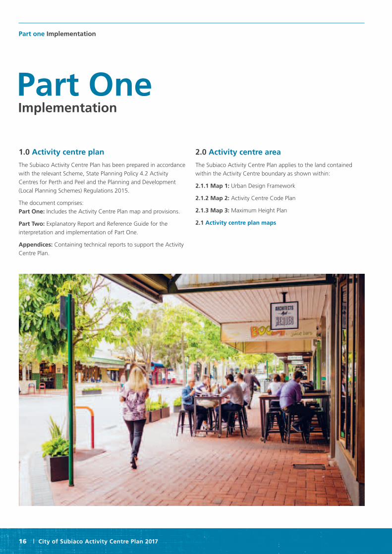
1.0 Activity centre plan
The Subiaco Activity Centre Plan has been prepared in accordance
with the relevant Scheme, State Planning Policy 4.2 Activity
Centres for Perth and Peel and the Planning and Development
(Local Planning Schemes) Regulations 2015.
The document comprises:
Part One: Includes the Activity Centre Plan map and provisions.
Part Two: Explanatory Report and Reference Guide for the
interpretation and implementation of Part One.
Appendices: Containing technical reports to support the Activity
Centre Plan.
2.0 Activity centre area
The Subiaco Activity Centre Plan applies to the land contained
within the Activity Centre boundary as shown within:
2.1.1 Map 1: Urban Design Framework
2.1.2 Map 2: Activity Centre Code Plan
2.1.3 Map 3: Maximum Height Plan
2.1 Activity centre plan maps
Part One Implementation

City of Subiaco Activity Centre Plan 2017 | 17
P
P
Railway Parade
Subiaco Road Subiaco Road Subiaco Road
Roberts RoadRoberts RoadRoberts Road
Cog
hlan
Roa
dC
oghl
an
R
oad
Ham
ilton
Str
eet
Rok
eby
Roa
d
Fede
ral
Str
eet
Cat
heri
ne S
tree
t
Axo
n
Str
eet
Elle
n
Str
eet
May
Aven
ue Thomas
S
treet
Thomas
S
treet
Thomas
S
treet
York StreetYork Street
Hay StreetHay StreetHay Street
Churchill AvenueChurchill AvenueChurchill AvenueForrest Street
Barker RoadBarker Road
Bagot RoadBagot Road
Lawler Road
Hamersley Road Hamersley Road Hamersley Road
Heytesbury RoadHeytesbury Road
Nicholson RoadNicholson Road
Heytesbury Road
Gloster Road
Finl
ayso
n S
tree
t
Sal
isbu
ry S
tree
t
Rob
inso
n S
tree
t
Sal
isbu
ry S
tree
t
Pro
clam
atio
n S
tree
t
Che
ster
Str
eet
Ker
shaw
Str
eet
Tow
nshe
nd R
oad
Tow
nshe
nd R
oad
Tow
nshe
nd R
oad
Fran
cis
Str
eet
Kin
g R
oad
Bed
ford
Ave
nue
Bed
ford
Ave
nue
Oliv
e S
tree
t
Rup
ert
Str
eet
Rup
ert
Str
eet
Rok
eby
Roa
d
Rup
ert
Str
eet
Rok
eby
R
oad
Rok
eby
Roa
dR
okeb
y R
oad
Uni
on S
tree
tU
nion
Str
eet
Hen
sman
R
oad
Hen
sman
R
oad
View
S
tree
t
Der
by
S
tree
t
Sadlier
S
treet
Der
by S
tree
t
Hen
sman
Roa
d
View
Str
eet
Hen
sman
Roa
d
Hamersley Road
Bagot Road
Salvado RoadSalvado Road
Barker Road
400M
400M
Landmark/threshold
Mixed Use
Residential
Public Focus/Park
Shared Carpark and Plaza
Town centre
Future 7 day High Frequency Public Transport
Transit Stop
Active Frontages
Public Parking (multi-deck)
Public Purpose
Town Centre Heritage Area
Local Development Plan Required
Activity Centre Boundary
Suggested Access Ways
400m threshold
Subiaco Station
Legend
P
ClientCity of Subiaco
Project Name Subiaco Activity Centre
File Path:\\per.work.hassell.info\sites\Projects\004734\Drawings\131121_04734_MAPS\131121_04734_MAP 1\131122_004734_MAP 1.ai
Date19th December 2013
Revision Scale1:5000@A2
Drawing131219_004734_Map 1
200m50m0m
CITY OF SUBIACOMAP 1
5
2.1.1 Map 1: Urban design framework
P
P
Railway Parade
Subiaco Road Subiaco Road Subiaco Road
Roberts RoadRoberts RoadRoberts Road
Cog
hlan
Roa
dC
oghl
an
R
oad
Ham
ilton
Str
eet
Rok
eby
Roa
d
Fede
ral
Str
eet
Cat
heri
ne S
tree
t
Axo
n
Str
eet
Elle
n
Str
eet
May
Aven
ue Thomas
S
treet
Thomas
S
treet
Thomas
S
treet
York StreetYork Street
Hay StreetHay StreetHay Street
Churchill AvenueChurchill AvenueChurchill AvenueForrest Street
Barker RoadBarker Road
Bagot RoadBagot Road
Lawler Road
Hamersley Road Hamersley Road Hamersley Road
Heytesbury RoadHeytesbury Road
Nicholson RoadNicholson Road
Heytesbury Road
Gloster Road
Finl
ayso
n S
tree
t
Sal
isbu
ry S
tree
t
Rob
inso
n S
tree
t
Sal
isbu
ry S
tree
t
Pro
clam
atio
n S
tree
t
Che
ster
Str
eet
Ker
shaw
Str
eet
Tow
nshe
nd R
oad
Tow
nshe
nd R
oad
Tow
nshe
nd R
oad
Fran
cis
Str
eet
Kin
g R
oad
Bed
ford
Ave
nue
Bed
ford
Ave
nue
Oliv
e S
tree
t
Rup
ert
Str
eet
Rup
ert
Str
eet
Rok
eby
Roa
d
Rup
ert
Str
eet
Rok
eby
R
oad
Rok
eby
Roa
dR
okeb
y R
oad
Uni
on S
tree
tU
nion
Str
eet
Hen
sman
R
oad
Hen
sman
R
oad
View
S
tree
t
Der
by
S
tree
t
Sadlier
S
treet
Der
by S
tree
t
Hen
sman
Roa
d
View
Str
eet
Hen
sman
Roa
d
Hamersley Road
Bagot Road
Salvado RoadSalvado Road
Barker Road
400M
400M
Landmark/threshold
Mixed Use
Residential
Public Focus/Park
Shared Carpark and Plaza
Town centre
Future 7 day High Frequency Public Transport
Transit Stop
Active Frontages
Public Parking (multi-deck)
Public Purpose
Town Centre Heritage Area
Local Development Plan Required
Activity Centre Boundary
Suggested Access Ways
400m threshold
Subiaco Station
Legend
P
ClientCity of Subiaco
Project Name Subiaco Activity Centre
File Path:\\per.work.hassell.info\sites\Projects\004734\Drawings\131121_04734_MAPS\131121_04734_MAP 1\131122_004734_MAP 1.ai
Date19th December 2013
Revision Scale1:5000@A2
Drawing131219_004734_Map 1
200m50m0m
CITY OF SUBIACOMAP 1
5
P
P
Railway Parade
Subiaco Road Subiaco Road Subiaco Road
Roberts RoadRoberts RoadRoberts Road
Cog
hlan
Roa
dC
oghl
an
R
oad
Ham
ilton
Str
eet
Rok
eby
Roa
d
Fede
ral
Str
eet
Cat
heri
ne S
tree
t
Axo
n
Str
eet
Elle
n
Str
eet
May
Aven
ue Thomas
S
treet
Thomas
S
treet
Thomas
S
treet
York StreetYork Street
Hay StreetHay StreetHay Street
Churchill AvenueChurchill AvenueChurchill AvenueForrest Street
Barker RoadBarker Road
Bagot RoadBagot Road
Lawler Road
Hamersley Road Hamersley Road Hamersley Road
Heytesbury RoadHeytesbury Road
Nicholson RoadNicholson Road
Heytesbury Road
Gloster Road
Finl
ayso
n S
tree
t
Sal
isbu
ry S
tree
t
Rob
inso
n S
tree
t
Sal
isbu
ry S
tree
t
Pro
clam
atio
n S
tree
t
Che
ster
Str
eet
Ker
shaw
Str
eet
Tow
nshe
nd R
oad
Tow
nshe
nd R
oad
Tow
nshe
nd R
oad
Fran
cis
Str
eet
Kin
g R
oad
Bed
ford
Ave
nue
Bed
ford
Ave
nue
Oliv
e S
tree
t
Rup
ert
Str
eet
Rup
ert
Str
eet
Rok
eby
Roa
d
Rup
ert
Str
eet
Rok
eby
R
oad
Rok
eby
Roa
dR
okeb
y R
oad
Uni
on S
tree
tU
nion
Str
eet
Hen
sman
R
oad
Hen
sman
R
oad
View
S
tree
t
Der
by
S
tree
t
Sadlier
S
treet
Der
by S
tree
t
Hen
sman
Roa
d
View
Str
eet
Hen
sman
Roa
d
Hamersley Road
Bagot Road
Salvado RoadSalvado Road
Barker Road
400M
400M
Landmark/threshold
Mixed Use
Residential
Public Focus/Park
Shared Carpark and Plaza
Town centre
Future 7 day High Frequency Public Transport
Transit Stop
Active Frontages
Public Parking (multi-deck)
Public Purpose
Town Centre Heritage Area
Local Development Plan Required
Activity Centre Boundary
Suggested Access Ways
400m threshold
Subiaco Station
Legend
P
ClientCity of Subiaco
Project Name Subiaco Activity Centre
File Path:\\per.work.hassell.info\sites\Projects\004734\Drawings\131121_04734_MAPS\131121_04734_MAP 1\131122_004734_MAP 1.ai
Date19th December 2013
Revision Scale1:5000@A2
Drawing131219_004734_Map 1
200m50m0m
CITY OF SUBIACOMAP 1
5
Railway Parade
Subiaco Road Subiaco Road Subiaco Road
Roberts RoadRoberts RoadRoberts Road
Cog
hlan
Roa
dC
oghl
an
R
oad
Ham
ilton
Str
eet
Rok
eby
Roa
d
Fede
ral
Str
eet
Cat
heri
ne S
tree
t
Axo
n
Str
eet
Elle
n
Str
eet
May
Aven
ue Thomas
S
treet
Thomas
S
treet
Thomas
S
treet
York StreetYork Street
Hay StreetHay StreetHay Street
Churchill AvenueChurchill AvenueChurchill AvenueForrest Street
Barker RoadBarker Road
Bagot RoadBagot Road
Lawler Road
Hamersley Road Hamersley Road Hamersley Road
Heytesbury RoadHeytesbury Road
Nicholson RoadNicholson Road
Heytesbury Road
Gloster Road
Finl
ayso
n S
tree
t
Sal
isbu
ry S
tree
t
Rob
inso
n S
tree
t
Sal
isbu
ry S
tree
t
Pro
clam
atio
n S
tree
t
Che
ster
Str
eet
Ker
shaw
Str
eet
Tow
nshe
nd R
oad
Tow
nshe
nd R
oad
Tow
nshe
nd R
oad
Fran
cis
Str
eet
Kin
g R
oad
Bed
ford
Ave
nue
Bed
ford
Ave
nue
Oliv
e S
tree
t
Rup
ert
Str
eet
Rup
ert
Str
eet
Rok
eby
Roa
d
Rup
ert
Str
eet
Rok
eby
R
oad
Rok
eby
Roa
dR
okeb
y R
oad
Uni
on S
tree
tU
nion
Str
eet
Hen
sman
R
oad
Hen
sman
R
oad
View
S
tree
t
Der
by
S
tree
t
Sadlier
S
treet
Der
by S
tree
t
Hen
sman
Roa
d
View
Str
eet
Hen
sman
Roa
d
Hamersley Road
Bagot Road
Salvado RoadSalvado Road
Barker Road
R-ACOR-ACOR-ACO R160 R80 R80 R80
PUBLIC OPEN SPACE PRIMARY SCHOOLCIVIC
CIVIC R-ACO
R-ACO R-ACO
R-ACO
R-ACO
R-ACO
R-ACO
R-ACO
R160
R-ACO R-ACOR-ACO
R-ACO
R-ACO R-ACO R-ACO
R50 R50
R-ACOR-ACO
R-ACO
R-ACO
R-ACO
R-ACO
R-ACO
R-ACOR-ACO
R-ACO
R-ACO
R80R80
R80R80
R80
R80
R80
PUBLIC OPEN SPACE
R-ACO
R-ACOR-ACO
R-ACO
R-ACO
R-ACO
R-ACO
R-ACO
R-ACO
R-ACO
R-ACO
HOSPITAL HOSPITAL
Public Purposes - Primary School: Local Reserve
Public Purposes - Hospital: Regional Reserve
Public Purposes - Hospital: Local Reserve
Civic and Cultural
Open Space
Centro
Town Centre Type A
Town Centre Type A - Transition
Mixed Use
Mixed Use - Transition
Town Centre Type B
Town Centre Type B - Transition
Residential - R160
Residential - R80
Residential - R50
Subject to Subiaco Redevelopment Scheme
Shared Carpark and Plaza
Public Parking (multi-deck)
Town Centre Heritage Area
Local Development Plan Required
Landmark Sites
Activity Centre Boundary
Suggested Access Ways
Legend
P
ClientCity of Subiaco
Project Name Subiaco Activity Centre
File Path:\\per.work.hassell.info\sites\Projects\004734\Drawings\131121_04734_MAPS\131121_04734_MAP 2\131122_004734_MAP 2.ai
Date22nd November 2013
Revision Scale1:5000@A2
Drawing131122_004734_Map 2
200m50m0m
CITY OF SUBIACOMAP 2
4

Part one Implementation
18 | City of Subiaco Activity Centre Plan 2017
Railway Parade
Subiaco Road Subiaco Road Subiaco Road
Roberts RoadRoberts RoadRoberts Road
Cog
hlan
Roa
dC
oghl
an
R
oad
Ham
ilton
Str
eet
Rok
eby
Roa
d
Fede
ral
Str
eet
Cat
heri
ne S
tree
t
Axo
n
Str
eet
Elle
n
Str
eet
May
Aven
ue Thomas
S
treet
Thomas
S
treet
Thomas
S
treet
York StreetYork Street
Hay StreetHay StreetHay Street
Churchill AvenueChurchill AvenueChurchill AvenueForrest Street
Barker RoadBarker Road
Bagot RoadBagot Road
Lawler Road
Hamersley Road Hamersley Road Hamersley Road
Heytesbury RoadHeytesbury Road
Nicholson RoadNicholson Road
Heytesbury Road
Gloster Road
Finl
ayso
n S
tree
t
Sal
isbu
ry S
tree
t
Rob
inso
n S
tree
t
Sal
isbu
ry S
tree
t
Pro
clam
atio
n S
tree
t
Che
ster
Str
eet
Ker
shaw
Str
eet
Tow
nshe
nd R
oad
Tow
nshe
nd R
oad
Tow
nshe
nd R
oad
Fran
cis
Str
eet
Kin
g R
oad
Bed
ford
Ave
nue
Bed
ford
Ave
nue
Oliv
e S
tree
t
Rup
ert
Str
eet
Rup
ert
Str
eet
Rok
eby
Roa
d
Rup
ert
Str
eet
Rok
eby
R
oad
Rok
eby
Roa
dR
okeb
y R
oad
Uni
on S
tree
tU
nion
Str
eet
Hen
sman
R
oad
Hen
sman
R
oad
View
S
tree
t
Der
by
S
tree
t
Sadlier
S
treet
Der
by S
tree
t
Hen
sman
Roa
d
View
Str
eet
Hen
sman
Roa
d
Hamersley Road
Bagot Road
Salvado RoadSalvado Road
Barker Road
R-ACOR-ACOR-ACO R160 R80 R80 R80
PUBLIC OPEN SPACE PRIMARY SCHOOLCIVIC
CIVIC R-ACO
R-ACO R-ACO
R-ACO
R-ACO
R-ACO
R-ACO
R-ACO
R160
R-ACO R-ACOR-ACO
R-ACO
R-ACO R-ACO R-ACO
R50 R50
R-ACOR-ACO
R-ACO
R-ACO
R-ACO
R-ACO
R-ACO
R-ACOR-ACO
R-ACO
R-ACO
R80R80
R80R80
R80
R80
R80
PUBLIC OPEN SPACE
R-ACO
R-ACOR-ACO
R-ACO
R-ACO
R-ACO
R-ACO
R-ACO
R-ACO
R-ACO
R-ACO
HOSPITAL HOSPITAL
Public Purposes - Primary School: Local Reserve
Public Purposes - Hospital: Regional Reserve
Public Purposes - Hospital: Local Reserve
Civic and Cultural
Open Space
Centro
Town Centre Type A
Town Centre Type A - Transition
Mixed Use
Mixed Use - Transition
Town Centre Type B
Town Centre Type B - Transition
Residential - R160
Residential - R80
Residential - R50
Subject to Subiaco Redevelopment Scheme
Shared Carpark and Plaza
Public Parking (multi-deck)
Town Centre Heritage Area
Local Development Plan Required
Landmark Sites
Activity Centre Boundary
Suggested Access Ways
Legend
P
ClientCity of Subiaco
Project Name Subiaco Activity Centre
File Path:\\per.work.hassell.info\sites\Projects\004734\Drawings\131121_04734_MAPS\131121_04734_MAP 2\131122_004734_MAP 2.ai
Date22nd November 2013
Revision Scale1:5000@A2
Drawing131122_004734_Map 2
200m50m0m
CITY OF SUBIACOMAP 2
4
2.1.2 Map 2: Activity centre code plan

City of Subiaco Activity Centre Plan 2017 | 19
* potential bonus height provisions apply
Railway Parade
Subiaco Road Subiaco Road
Roberts RoadRoberts RoadRoberts Road
Cog
hlan
Roa
dC
oghl
an
R
oad
Rok
eby
Roa
d
Fede
ral
Str
eet
Axo
n
Str
eet
Elle
n
Str
eet
May
Aven
ue
Thomas
S
treet
York StreetYork Street
Hay StreetHay StreetHay Street
Churchill AvenueChurchill AvenueChurchill AvenueForrest Street
Barker RoadBarker Road
Bagot RoadBagot Road
Lawler Road
Hamersley Road Hamersley Road Hamersley Road
Heytesbury RoadHeytesbury RoadHeytesbury Road
Gloster Road
Finl
ayso
n S
tree
t
Sal
isbu
ry S
tree
t
Rob
inso
n S
tree
t
Sal
isbu
ry S
tree
t
Pro
clam
atio
n S
tree
t
Che
ster
Str
eet
Ker
shaw
Str
eet
Tow
nshe
nd R
oad
Tow
nshe
nd R
oad
Tow
nshe
nd R
oad
Fran
cis
Str
eet
Kin
g R
oad
Bed
ford
Ave
nue
Bed
ford
Ave
nue
Oliv
e S
tree
t
Rup
ert
Str
eet
Rup
ert
Str
eet
Rok
eby
Roa
d
Rup
ert
Str
eet
Rok
eby
R
oad
Rok
eby
Roa
dR
okeb
y R
oad
Uni
on S
tree
tU
nion
Str
eet
Hen
sman
R
oad
Hen
sman
R
oad
View
S
tree
t
Der
by
S
tree
t
Sadlier
S
treet
Der
by S
tree
t
Hen
sman
Roa
d
View
Str
eet
Hen
sman
Roa
d
Hamersley Road
Bagot Road
Salvado RoadSalvado Road
Barker RoadC
athe
rine
Str
eet
Public Focus/Park
Shared Carpark and Plaza
Refer Transitional Height Provisions
Reserve: No Height Standards Apply
As per Subiaco Redevelopment Scheme
Town Centre Heritage Area
Activity Centre Boundary
Landmark Sites
Suggested Access Ways
Height provisions as per Local Planning Scheme
Height limit of 10 storeys
Height limit of 7 storeys
Height limit of 6 storeys. Potential for bonus 2 storeys, subject to Council approval*
Height limit of 5 storeys Height limit of 4 storeys. Potential 2 additional storeys to be setback from the street, subject to Council approval
Height limit of 4 storeys. (nb: heritage area bulk prov. apply)
Height limit of 3 storeys
Height limit of 2 storeys
As per Residential Design Codes
Legend
CITY OF SUBIACOMAP 3
Nicholson RoadNicholson Road
* potential bonus height provisions apply
Railway Parade
Subiaco Road Subiaco Road
Roberts RoadRoberts RoadRoberts Road
Cog
hlan
Roa
dC
oghl
an
R
oad
Rok
eby
Roa
d
Fede
ral
Str
eet
Axo
n
Str
eet
Elle
n
Str
eet
May
Aven
ue
Thomas
S
treet
York StreetYork Street
Hay StreetHay StreetHay Street
Churchill AvenueChurchill AvenueChurchill AvenueForrest Street
Barker RoadBarker Road
Bagot RoadBagot Road
Lawler Road
Hamersley Road Hamersley Road Hamersley Road
Heytesbury RoadHeytesbury RoadHeytesbury Road
Gloster Road
Finl
ayso
n S
tree
t
Sal
isbu
ry S
tree
t
Rob
inso
n S
tree
t
Sal
isbu
ry S
tree
t
Pro
clam
atio
n S
tree
t
Che
ster
Str
eet
Ker
shaw
Str
eet
Tow
nshe
nd R
oad
Tow
nshe
nd R
oad
Tow
nshe
nd R
oad
Fran
cis
Str
eet
Kin
g R
oad
Bed
ford
Ave
nue
Bed
ford
Ave
nue
Oliv
e S
tree
t
Rup
ert
Str
eet
Rup
ert
Str
eet
Rok
eby
Roa
d
Rup
ert
Str
eet
Rok
eby
R
oad
Rok
eby
Roa
dR
okeb
y R
oad
Uni
on S
tree
tU
nion
Str
eet
Hen
sman
R
oad
Hen
sman
R
oad
View
S
tree
t
Der
by
S
tree
t
Sadlier
S
treet
Der
by S
tree
t
Hen
sman
Roa
d
View
Str
eet
Hen
sman
Roa
d
Hamersley Road
Bagot Road
Salvado RoadSalvado Road
Barker Road
Cat
heri
ne S
tree
t
Public Focus/Park
Shared Carpark and Plaza
Refer Transitional Height Provisions
Reserve: No Height Standards Apply
As per Subiaco Redevelopment Scheme
Town Centre Heritage Area
Activity Centre Boundary
Landmark Sites
Suggested Access Ways
Height provisions as per Local Planning Scheme
Height limit of 10 storeys
Height limit of 7 storeys
Height limit of 6 storeys. Potential for bonus 2 storeys, subject to Council approval*
Height limit of 5 storeys Height limit of 4 storeys. Potential 2 additional storeys to be setback from the street, subject to Council approval
Height limit of 4 storeys. (nb: heritage area bulk prov. apply)
Height limit of 3 storeys
Height limit of 2 storeys
As per Residential Design Codes
Legend
CITY OF SUBIACOMAP 3
Nicholson RoadNicholson Road
2.1.3 Map 3: Maximum height plan

Part one Implementation
20 | City of Subiaco Activity Centre Plan 2017
3.0 Operation
The Subiaco Activity Centre Plan comes into effect on the date it
is approved by the Western Australian Planning Commission. It is
to be read in conjunction with the City of Subiaco local planning
scheme. Where any provision of the Subiaco Activity Centre Plan
conflicts with the local planning scheme, the Scheme prevails.
3.1 Relationship to Subiaco Redevelopment Area The Subiaco Activity Centre Plan includes land within the
Subiaco Redevelopment Area. The Subiaco Activity Centre Plan
acknowledges and responds to the land use, form and activities
within the Subiaco Redevelopment Area but does not apply
to this area which is subject to a separate scheme, Subiaco
Redevelopment Scheme 1996 (as amended) and policy provisions
under the Metropolitan Redevelopment Act 2011.
The Metropolitan Redevelopment Authority is the responsible
decision-making authority for this area.
4.0 Objectives
The objectives of the Activity Centre Plan are to create a vibrant,
sustainable, well serviced by public transport city centre with a
focus on economic sustainability.
4.1 General objectives 4.1.1 An active, vibrant and diverse town centre a. Providing an artful mix of active land uses at ground level
within the Town Centre.
b. To consolidate comparison retail activity within the Town Centre.
c. The provision of an inviting public realm that attracts people to
it and encourages greater ‘dwell’ times – inviting people to stay
longer in Subiaco will make it a more successful centre.
d. The provision of a high quality public realm matched to the
needs of the community and local businesses.
e. Reinforcing Subiaco’s point of difference – the character of
Rokeby Road and Hay Street contribute significantly to people’s
sense of place and experience. Enhancing and protecting
the scale and character of buildings at the street interface
is important.
f. Enhancing the quality of the walking experience – Rokeby
Road and Hay Street must be focused on a comfortable, safe and
engaging pedestrian experience.
g. Applying increased residential use in mixed use development
that enhances the function of Subiaco’s public space network.
4.1.2 A renewed focus for the economy and development a. Access: Integrate mixed land uses around public transport and
improve the pedestrian and cycling experience to and through
Subiaco so as to ensure their priority over the private car.
b. Promote further development of professional services and
information / technology sectors within Subiaco that act as talent
magnets within Subiaco.
c. Enable development of an appropriate amount of additional
office space throughout Subiaco to meet sub-regional
employment targets.
d. Maximise links (public transport and cycle) between Subiaco
and the QEII / UWA Specialised Centre; promote the development
of higher density, affordable housing within Subiaco Activity
Centre that enables professionals to live in close proximity to
UWA / QEII.
e. Develop a high quality network of public spaces and associated
activities throughout the activity centre that promotes improved
quality of living and enables exchange between professionals.
4.1.3 Sustainable urbanism that protects Subiaco’s heritage a. Ensure that heritage properties and Subiaco’s established
character are enhanced through appropriate protection
mechanisms and development standards.
b. Apply appropriate R-Code density and built form standards
across the centre to enable housing targets to be met.
c. Encourage minimum standards in terms of design and
environmental quality.
4.1.4 A strong network of high quality public places a. Enable built form and urban design responses around each
public space area that reinforces quality and functionality, based
on ‘hot spots’ of activity and public focus.
b. Ensure place activation for public spaces that reinforces their
purpose.
c. Encourage a mix of high quality businesses in and around each
public space commensurate with their intended role / function.
d. Improve the quality and comfort of the public realm.
4.1.5 A prioritised and sustainable transport network a. Ensure a great variety of land uses, transport and public space
options are present within close walking distance of people.
b. Ensure that the quality of the walking experience is emphasised
in every detail through the public realm.
c. The provision of passive surveillance, active shop fronts (where
required) and built form that addresses the street.
d. Ensure alternative means of access such as cycling and public
transport are convenient, safe and comfortable.
e. Support public transport links to key destinations at all times.

City of Subiaco Activity Centre Plan 2017 | 21
4.2 Activity Centre Code Objectives
The Activity Centre has been divided into six activity centre
codes comprising:
• Town Centre Type ‘A’
• Town Centre Type ‘B’
• Centro
• Mixed Use
• Residential
• Town Centre Type ‘A’, Town Centre Type ‘B’ and Mixed Use
Transition Areas
In addition, the Activity Centre Plan Map outlines the following
zones and reserves:
• Public Purposes – Primary School
• Public Purposes – Hospital
• Civic and Cultural
• Public Open Space
4.2.1 Town Centre Type ‘A’ The Town Centre ‘A’ Code is Subiaco’s principal location for
commercial, civic, entertainment and retail activity. It will gain
in popularity as a residential location for those seeking an urban
lifestyle. Diversity and vitality are fundamental to the overall land
use profile, facilitated by providing the widest range of facilities
and services which enables Subiaco’s centre to fulfil its many
functions while sustaining interest and activity on a virtually
continuous basis. The scale and intensity of activities help to
distinguish it from surrounding areas, both in terms of maximising
the potential of Subiaco for transit oriented development, and to
respect the acknowledged heritage qualities of Rokeby Road and
Hay Street.
4.2.2 Town Centre Type ‘B’
The Town Centre ‘B’ Code complements and mirrors the function of
the Town Centre ‘A’ zone, however its development scale is slightly
lower reflective of local topography and distance from Subiaco
Station. Town Centre ‘B’ will be a principal location for commercial,
civic, entertainment and retail activity. It will gain in popularity as
a residential location for those seeking an urban lifestyle. Diversity
and vitality are fundamental to the overall land use profile, facilitated
by providing the widest range of facilities and services which enables
Subiaco’s centre to fulfil its many functions while sustaining interest
and activity on a virtually continuous basis. The scale and intensity
of activities help to distinguish it from surrounding areas, both in
terms of maximising the potential of Subiaco for transit oriented
development, and to respect the acknowledged heritage qualities of
Rokeby Road and Hay Street.
4.2.3 Centro The Centro Code is intended to develop as mixed use areas
comprising primarily permanent residential accommodation
and office / business activities, together with a range of
complementary uses. Ground floor development shall generally
be non-residential with upper floors containing a mix of residential
and non-residential uses in a complementary manner.
4.2.4 Mixed use The Mixed Use Code is intended to develop as lively and diverse
mixed use areas providing for an extensive range of residential
and commercial uses to be established either in association with
each other or independently in a compatible manner. Mixed
residential / commercial development is strongly encouraged,
provided that conflict between the residential and non-residential
components is minimised. Development fronting Rokeby and
Bagot Roads shall contain a non-residential ground floor use.
4.2.5 Residential The emphasis in the Residential Code is very much on permanent
residential accommodation, generally in the form of multiple
dwellings, developed in accordance with the Residential Design
Codes. A limited range of complementary uses may also be
considered appropriate in certain instances, provided that the
amenity of surrounding residential fabric is adequately preserved.
4.2.6 Transition areas Transition areas provide for appropriately scaled development
standards that provide an interface between the low density
residential areas in the suburban streets and the development
within the Activity Centre.
Notwithstanding any stated development standards, the following
development standards shall apply to those areas denoted as
transition areas on the Activity Centre Code Plan. The following
development standards shall apply to those areas denoted as
transition areas on Map 2, within Part 1 of this report.
a. Town Centre ‘A’ Transition Area Catherine Street:
- A height of two storeys and 8.5 metres shall apply to
development to provide a complementary scale to residential
development opposite on land zoned Residential R50.
- The two storey height limit shall apply for a measure of
15 metres west from the Catherine Street boundary.
b. Town Centre ‘A’ Transition Area York Street:
- A height of three storeys and 12 metres shall apply to
development to provide a complementary scale to residential
development opposite on land zoned Residential R50.
- The three storey height limit shall apply at the street interface
for a measure of 3 metres from the York Street boundary.
c. Town Centre ‘A’ Churchill Avenue:
- A height of three storeys and 12 metres shall apply to
development to provide a complementary scale to residential
development opposite on land zoned R50.
- The three storey height limit shall apply for a measure of
5 metres north of the building interface.

Part one Implementation
22 | City of Subiaco Activity Centre Plan 2017
d. Town Centre ‘B’ Type Transition Area:
- Side setbacks and height shall match the adjacent residential
zone development standards for a measure of 4 metres from
the eastern boundary.
e. Mixed Use Transition Area:
- A three storey and 12 metre height limit shall apply to
development that interfaces with the adjacent laneway for a
measure of 10 metres west from the laneway boundary.
5.0 Land use
The Activity Centre Code Plan outlines land use, zones, activity
centre code and reserves applicable within the Activity Centre
Plan area.
5.1 Land Use Permissibility Land use shall be in accordance with the zoning table under the
City of Subiaco local planning scheme or other scheme provision.
When determining development applications, the City shall also
have regard to Activity Centre Code Objectives under clause 4.2
of this Plan.
5.2 Ground floor land use
Ground floor land use shall be non-residential within all activity
centre code areas except for the residential activity centre code
area, except where approved by the Council.
6.0 Subdivision
When considering an application for subdivision, due regard shall
be given to:
a. The intended function of the land and the activities carried out
on it.
b. The intended character of the area.
c. The intended amenity of the area
d. Built form implications of subdivision
e. The established scale and grain of development
f. Implications on vehicle access and servicing
6.1 Memorials on title Notifications will be placed on all titles within the activity centre in
order to alert purchasers of the potential impacts of living in the
activity centre such as noise and parking.
7.0 Development requirements
7.1 Activity centre code development standards Development within each of the activity centre codes shall be
developed according to Table 1: Development Standards and the
associated provisions in this part as follows. Notwithstanding any
of these provisions, any development standard or provision in the
local planning scheme applies and shall prevail.
7.1.1 Transition Areas
Notwithstanding any other stated development standards, the
following development standards shall apply to those areas
denoted as transition areas in Map 2 Activity Centre Code Plan.
a. Town Centre ‘A’ Transition Area Catherine Street:
A height of two storeys and 8.5 metres shall apply to
development to provide a complementary scale to residential
development opposite on land zoned Residential R50. The two
storey height limit shall apply for a measure of 15 metres west
from the Catherine Street boundary.
b. Town Centre ‘A’ Transition Area York Street:
A height of three storeys and 12 metres shall apply to
development to provide a complementary scale to residential
development opposite on land zoned Residential R50. The three
storey height limit shall apply at the street interface for a measure
of 3 metres from the York Street boundary.
c. Town Centre ‘A’ Churchill Avenue:
A height of three storeys and 12 metres shall apply to development
to provide a complementary scale to residential development
opposite on land zoned R50. The three storey height limit shall
apply for a measure of 5 metres north of the building interface.
d. Town Centre ‘B’ Type Transition Area:
Side setbacks and height shall match the adjacent residential
zone development standards for a measure of 4 metres from the
eastern boundary.
e. Mixed Use Transition Area:
A three storey and 12 metre height limit shall apply to
development that interfaces with the adjacent laneway for a
measure of 10 metres west from the laneway boundary.
7.1.2 Rokeby Road and Hay Street heritage area Notwithstanding any activity centre code specific development
standards, the following height and setback provisions shall apply
to any development within the Rokeby Road and Hay Street
Heritage Area as denoted on the Activity Centre Plan Map:
a. Heritage fabric to be retained and conserved as identified by
“Assessment of the Rokeby Road and Hay Street Heritage Area”
report (Griffiths Architects, 2013) and Local Planning Policy 3.8
‘Development guidelines for the Rokeby Road and Hay Street
Heritage Area’.
b. New development shall be consistent with Burra Charter
principles and be designed in a contemporary manner.
c. A maximum street interface of two storeys and 8.5 metres
shall apply.
d. Taller development shall be set back from the street façade
by 6 metres up to a maximum height of 4 storeys and 15.5 metres
(excluding roofs, architectural features, lift over-runs and
plant equipment).

City of Subiaco Activity Centre Plan 2017 | 23
e. Development on corner lots may exceed the two storey and
8.5 metre street interface height to include a landmark design
feature up to an additional storey (3.25 metres) for a distance of
10 metres measured from the corner along the street boundaries.
f. Planning Policy 3.8 for the Rokeby Road and Hay Street
Heritage Area, clause 11.5 requires second stories to a single
storey contributory heritage building to have a minimum of a 6m
setback. The best heritage outcome is for any new development
to be set below the line of sight from the opposite side of the
street. The decision making authority will consider development
proposals on a case-by-case basis, with the potential degree of
impact of any proposed development visible above the sight line.
g. Side Setbacks: Nil for the height of the street interface for
a measure of 15 metres from the street boundary after which
development above two storeys shall be set back by 3 metres.
h. Rear Setbacks: Nil for development up to two storeys.
Development above two storeys shall be set back by 6 metres.
i. Where development abuts a lane or Right of Way, development
above three storeys shall be set back by 3 metres.
j. Development adjacent to a heritage place shall provide a
complementary bulk and character including respecting scale and
architectural lines.
k. Variations to the street interface height, side and rear setbacks
will be contemplated subject to impact on street amenity, comfort
and on recommendation from a qualified heritage architect in the
form of a Heritage Impact Statement.
7.1.3 Plot ratio Unless otherwise provided in the Activity Centre Plan provisions,
the plot ratio of development is to comply with the plot ratios
specified in Table 1: Development Standards.
7.1.4 Reserves Development on land identified as a reserve shall be
consistent with the relevant part of the City of Subiaco Local
Planning Scheme.
7.1.5 Shop development Where development proposes ‘shop’ land use in the Centro and
Mixed Use coded area, the maximum floor area shall be 500
square metres Net Lettable Area, except where:
a. The proposed floor area is supported by a Retail Sustainability
Assessment;
b. The proposal has been advertised for public comment; and
c. The Council is satisfied that the proposal is consistent with the
intent and objectives of the Subiaco Activity Centre plan.
7.1.6 Street interface
7.1.6.1 Active edges a. Where a site is identified on Map 1: Urban Design Framework
as having an active frontage, the ground floor shall contain a
shop, restaurant, small bar, café, or other similar active land use to
promote a vibrant town centre.
b. Residential development is not permitted on the ground
floor where an active frontage is defined by Map 1: Urban
Design Framework.
c. Upper floors will contain a mix of other land uses including
residential dwellings, offices or similar land uses consistent with
the operation of Subiaco as a secondary activity centre.
7.1.6.2 Scale and grain a. New development shall reflect a fine grain of development
consistent with the surrounding development context.
b. The street façade of development shall be designed to promote
surveillance of the street and include windows, doors and
balconies at upper levels.
7.1.7 Vehicle parking and access a. Only one vehicle crossover per lot is permitted except where
the Council is satisfied that no adverse effects on vehicular or
pedestrian traffic and/or conflict will result should a variation be
permitted which allows for more than one vehicular crossover to
a lot. Council is most keen to see the amalgamation of small car
parking areas on individual lots together with shared vehicular
crossovers in a bid to reduce vehicular and pedestrian conflict and
to improve the overall streetscape.
b. Car parking rates as per the relevant Local Planning Scheme or
any associated Local Planning Policy.
c. Applications for changes to land use shall not require additional
car parking bays where a higher car parking rate is established by
the Scheme, unless determined by the Council.
7.1.8 Bicycle parking Bicycle parking, access and end of trip facilities shall be provided
in accordance with the relevant City of Subiaco Local Planning
Scheme and Local Planning Policy 2.14: ‘End of Trip Facilities’.
7.1.9 Lift over-runs, rooftop plant rooms and architectural features a. Lifts over-runs and rooftop plant rooms are excluded from
the maximum height provisions, but must not extend more than
3.5 metres above the stated maximum height.
b. Lifts over-runs and rooftop plant rooms are to be limited
building components and should not significantly increase the
bulk of the building.

Part one Implementation
24 | City of Subiaco Activity Centre Plan 2017
c. Architectural features may extend above the maximum height
subject to approval by the Council.
d. Minor projections as defined by the Residential Design Codes
are excluded from the maximum height calculation.
e. All building plant and service equipment shall be screened from
public view from the street and areas of open space.
7.1.10 Parapets A parapet should be provided to the edge of any roof with a pitch
of less than 10 degrees.
7.1.11 Boundary walls a. For development within a residential activity centre code
area, boundary wall provisions of the Residential Design Codes
shall apply.
b. For all other development, boundary walls are permitted where
nil setbacks are described in Table 1: Development Standards.
7.1.12 Set backsNotwithstanding street height, street interface, side and rear
boundary provisions, where an existing dwelling on an adjacent
site has major openings, balconies or terraces within three metres
of the boundary, development shall be set back 3 metres from
that part of the boundary or as otherwise determined appropriate
by the approval authority.
7.1.13 Entrances a. A minimum of one entrance to a building must be clearly visible
and directly accessible from a street or pedestrian mall.
b. Separate entrances shall be provided for residential and
non-residential components of a mixed use development.
7.1.14 Servicing a. A storage area for refuse and recyclable material must be
provided on the land and the area must not be visible from
any street.
b. Facilities must be provided on the land for the loading and
unloading of service and delivery vehicles.
7.1.15 Material and finishes a. All external finishes of a building are to be constructed of
high quality materials, including but not limited to masonry,
timber or glass.
b. A concrete wall must be painted and provided with an
articulated or detailed finish.
c. A window in an external wall of a building which faces north,
east or west must be protected from direct summer sun.
7.1.16 Landscaping a. Uncovered car parking at ground level must be provided with
one shade tree per 4 car parking bays.
b. Development applications over 1,000 square metres for
non-residential development or more than 10 dwellings must
be supported by a landscaping management plan to include
endemic, native or robust drought resistant plants that will survive
with little irrigation after establishment.
7.1.17 Noise attenuation a. Each Development Application over 1,000 square metres for
non-residential development or more than 10 dwellings and all
mixed use development will require the preparation of a noise
management plan to ensure that noise levels inside residences
(including adjoining and nearby residences) will not exceed
established limits as prescribed in the Environmental Protection
(Noise) Regulations 1997 (as amended).
The plan is to be prepared by a suitably qualified consultant and is
to include:
(i) sound proofing measures used in the design and
construction of the development
(ii) predictions of noise
(iii) control measures to be undertaken (including monitoring
procedures), and
(iv) a complaint response procedure (for commercial activities
within a mixed-use building/or contained as part of a land
use management plan).
All sound attenuation measures, identified by the plan or as
additionally required by the Council, are to be implemented prior
to occupancy of the development or as otherwise required by the
Council, and the requirements of the plan are to be observed at
all times.
b. All mixed-use buildings that include a residential component
must be designed to minimise structural noise transfer between
ground floor commercial or retail uses and the residences above.
In addition, where significant noise generators are anticipated as
part of a project, double-glazing of windows and sliding doors
should also be considered to reduce noise impacts on residents.
Appropriate methods of construction are to be employed to limit
the intrusion of airborne and impact noise into dwellings from
adjacent dwellings and public areas to within the limits set out in
the BCA.
7.1.18 Resource conservation An ESD Management Plan and Green Travel Plan are required for
all larger developments comprising of 10 or more new residential
dwellings, or non-residential developments of more than 1000m²
Gross Floor Area (including alterations or additions). The ESD
Management Plan and Green Travel Plan shall be prepared
in accordance with the City of Subiaco’s Guide to ESD
Management Plans.
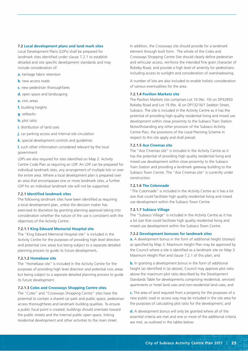
City of Subiaco Activity Centre Plan 2017 | 25
7.2 Local development plans and land mark sites Local Development Plans (LDPs) shall be prepared for
landmark sites identified under clause 7.2.1 to establish
detailed and site specific development standards and may
include consideration of:
a. heritage fabric retention
b. new access roads
c. new pedestrian thoroughfares
d. open space and landscaping
e. civic areas
f. building heights
g. setbacks
h. plot ratio
i. distribution of land uses
j. car parking access and internal site circulation
k. special development controls and guidelines
l. such other information considered relevant by the local
government
LDPs are also required for sites identified on Map 2: Activity
Centre Code Plan as requiring an LDP. An LDP can be prepared for
individual landmark sites, any arrangement of multiple lots or over
the entire area. Where a local development plan is prepared over
an area that encompasses one or more landmark sites, a further
LDP for an individual landmark site will not be supported.
7.2.1 Identified landmark sites The following landmark sites have been identified as requiring
a local development plan, unless the decision maker has
exercised its discretion by granting planning approval taking into
consideration whether the nature of the use is consistent with the
objectives of the Activity Centre.
7.2.1.1 King Edward Memorial Hospital site The “King Edward Memorial Hospital site” is included in the
Activity Centre for the purposes of providing high level direction
and potential civic areas but being subject to a separate detailed
planning process to guide its future development.
7.2.1.2 Homebase site The “Homebase site” is included in the Activity Centre for the
purposes of providing high level direction and potential civic areas
but being subject to a separate detailed planning process to guide
its future development.
7.2.1.3 Coles and Crossways Shopping Centre sites The “Coles” and “Crossways Shopping Centre” sites have the
potential to contain a shared car park and public space, pedestrian
access thoroughfares and landmark building qualities. To ensure
a public focal point is created, buildings should orientate toward
the public streets and the internal public open space, linking
residential development and other activities to the main street.
In addition, the Crossways site should provide for a landmark
element through built form. The whole of the Coles and
Crossways Shopping Centre Site should clearly define pedestrian
and vehicular access, reinforce the intended fine grain character of
Rokeby Road, and provide a high level of amenity for pedestrians
including access to sunlight and consideration of overshadowing.
A number of lots are also included to enable holistic consideration
of various eventualities for the area.
7.2.1.4 Pavilion Markets site The Pavilion Markets site comprises Lot 10 (No. 10) on DP32850
Rokeby Road and Lot 19 (No. 4) on DP13216/1 Seddon Street,
Subiaco. The site is included in the Activity Centre as it has the
potential of providing high quality residential living and mixed use
development within close proximity to the Subiaco Train Station.
Notwithstanding any other provision of the Subiaco Activity
Centre Plan, the provisions of the Local Planning Scheme in
respect to this site apply and shall prevail.
7.2.1.5 Ace Cinemas site The “Ace Cinemas site” is included in the Activity Centre as it
has the potential of providing high quality residential living and
mixed use development within close proximity to the Subiaco
Train Station and providing a landmark gateway building to the
Subiaco Town Centre. The “Ace Cinemas site” is currently under
construction.
7.2.1.6 The Colonnade “The Colonnade” is included in the Activity Centre as it has a lot
size that could facilitate high quality residential living and mixed
use development within the Subiaco Town Centre.
7.2.1.7 Subiaco Village The “Subiaco Village” is included in the Activity Centre as it has
a lot size that could facilitate high quality residential living and
mixed use development within the Subiaco Town Centre.
7.2.2 Development bonuses for landmark sites a. A development bonus in the form of additional height (storeys)
as specified by Map 3: Maximum Height Plan may be approved by
the Council where a site is identified as a landmark site on Map 3:
Maximum Height Plan and clause 7.2.1 of this plan; and
b. In granting a development bonus in the form of additional
height (as identified in (a) above), Council may approve plot ratio
above the maximum plot ratio described by the Development
Standards Table for developments comprising residential, serviced
apartments or hotel land uses and non-residential land uses; and
c. The area of land required from a property for the purposes of a
new public road or access way may be included in the site area for
the purposes of calculating plot ratio for the development; and
d. A development bonus will only be granted where all of the
essential criteria are met and one or more of the additional criteria
are met, as outlined in the tables below:

Part one Implementation
26 | City of Subiaco Activity Centre Plan 2017
Essential Criteria
• The development bonus comprises a minimum 60%
residential land use
• High quality design as determined by the City of Subiaco
Design Review Panel
• A new road or pedestrian access way is provided through
the site where it has been identified as desirable by the
Activity Centre Plan or outlined in the applicable Local
Development Plan
Additional Criteria
• Retention and enhancement of places of heritage significance
beyond the statutory requirements to protect and maintain
• A public plaza or open space is provided
• Pedestrian access is provided throughout the site on a
permanent basis
• The development is designed and constructed to a 5 star
Greenstar rating as accredited by the Australian Green
Building Council, or an equivalent system as agreed by
the Council
7.3 Discretionary clauseVariations to standards prescribed under the Activity Centre Plan
a. Except for development in respect of which the Residential
Design Codes apply, if a development is the subject of an
application for planning approval and does not comply with a
standard or requirement prescribed under the Activity Centre Plan,
the local government, may, despite the non-compliance, approve
the application unconditionally or subject to such conditions as
the local government thinks fit.
b. In considering an application for planning approval under
this clause, where, in the opinion of the local government, the
variation is likely to affect any owners or occupiers of any land in
the locality, the local government is to —
i. consult with the affected parties by following one or more
of the provisions for advertising uses under clause 26 of
Town Planning Scheme No. 4, Schedule 2, Part 8, Clause 64
of the Planning and Development (Local Planning Schemes)
Regulations 2015 and Planning Policy 1.4; and
ii. have regard to any submissions received or expressed views
prior to making its determination to grant the variation.
c. The power conferred by this clause may only be exercised if the
local government is satisfied that —
i. approval of the proposed development would be appropriate
having regard to the intent and objectives of the Activity Centre
Plan and Activity Centre Code Areas.
ii. the non-compliance will not have an undue adverse effect upon
the occupiers or users of the development, the inhabitants of
the locality or the likely future development of the locality.
d. Where non-compliance concerns building height, variations
shall only be granted where:
i. A local development plan has been approved permitting
building variations.
ii. For sites with a maximum height of 4 storeys additional height
up to 2 storeys subject to the following criteria being satisfied:
• The additional floor space comprises a minimum of 60%
residential land use; and
• The development demonstrates high quality design as
determined by the city of subiaco design review panel; and
• The additional height is setback from the street a minimum
of 6 metres.
iii. For non-landmark sites, where height variation does not
comprise an additional level or storey of development above
the maximum prescribed by the Activity Centre Plan.
iv. The degree to which the overall height graduates the
scale between existing buildings of varying heights within
the locality.
8.0 Other requirements
8.1 Policies The development of policies will put a range of finer grained
controls into effect that would not be appropriate to impose
through the Activity Centre Plan. These policies may cover such
aspects as (but not limited to):
• Promotion of Green building programs, technologies
and design;
• Guidance on development within each of the activity
centre codes;
• Provision of bicycle parking and end of trip facilities; and
• Provision of public art.
8.2 Staging and monitoring The Subiaco Activity Centre Plan will guide development within
the centre. Where it becomes evident that a clearly defined
staging strategy will facilitate delivery of the plan the local
authority in collaboration with the community and relevant
stakeholders will identify specific tasks and responsibilities that are
matched to a manageable and realistic timeframe.
A work program that considers the influences of land ownership,
funding/investment availability and delivery partnerships would
be prepared prioritising short, medium and long-term initiatives.
Importantly, the program will remain flexible to take into account
market influences.

City of Subiaco Activity Centre Plan 2017 | 27
8.1.1 Regular reviews The Subiaco Activity Centre Plan should be reviewed regularly to
ensure the objectives are being met and remain viable.
The City of Subiaco will periodically assess the impact of policies
and development applications on centre development, vitality
and viability.
9.0 Definitions Unless the context otherwise requires, words and expressions used
in the Activity Centre Plan have the same meaning as they have:
a. in the Planning and Development Act 2005; or
b. if they are not defined in that Act —
• in the Dictionary of defined words and expressions in Part 1, cl.
11 of the Activity Centre Plan or
• in the Residential Design Codes.
If there is a conflict between the meaning of a word or expression
in the Dictionary of defined words and expressions in Schedule
1 and the meaning of that word or expression in the Residential
Design Codes -
c. in the case of a residential development, the definition in the
Residential Design Codes prevails; and
d. in any other case the definition in the Dictionary prevails.
In this Activity Centre Plan:
“Activity Centre Code”: means the areas defined on the Activity
Centre Code Plan;
“Loft”: means a space contained wholly within the roof of a
building including space served by dormer windows but cannot
have a balcony or terrace;
“Public Space Area”: means the area defined in green on the
Subiaco Activity Centre Plan Map 1: Urban Design Framework;
“Rear setback” relates to a boundary that is not a street or to
another lot (ie. a right of way (ROW), public access way (PAW) or
public open space (POS)).
“Serviced Apartments”: means a building or buildings, which
include self-contained units, for temporary accommodation of less
than 3 months.
“Side setback” means setback to another lot boundary, not a
ROW or PAW.
“Storey”: means a space within a building which is situated
between the top of any floor and the top of the floor next above
it (or if there is no floor above, between the top of the floor
and the ceiling or roof above) and does not include a basement,
mezzanine or loft;

Part one Implementation
28 | City of Subiaco Activity Centre Plan 2017
Table 1: Development standards
Activity Centre Code R-Code Maximum Plot Ratio Minimum Open Space (% of site)
Street Setback Maximum height (4.25 metres per ground and first storey and 3.5 metres per storey thereafter) (excluding roofs)
Side Setback Rear Setback
Street Interface Additional Height: Southern Street
Boundary
Additional Height: Other Street Boundaries
Residential R160 As per Residential Design Codes Height of 4 storeys and 15.5 metres to the street interface as identified on the
Acitvity Centre Code Plan and Height Plan.
Development above the street interface shall be set back
sufficiently to enable sunlight access to the opposite footpath at
12 noon on the winter solstice or a minimum
3 metres.
Additional height as described on
the Height Plan set back from the street bounday by 6 metres.
As per Residential Design Codes Table 5.
3 metres for the first three storeys and
4 metres thereafter.
Residential R80 As per Residential Design Codes Height of 3 storeys and 12 metres to the street
interface.
No additional height. No additional height As per Residential Design Codes Table 2a
or 5 as appropriate.
Multiple Dwellings: 3 metres for the first
three storeys and 4 metres thereafter.
Other Dwellings: As per Residential
Design Codes Table 2a and/or Figure 4e.
Residential R50 As per Residential Design Codes Height of 2 storeys and 8.5 metres.
No additional height. No additional height. As per Residential Design Codes Table 2a
or 5 as appropriate.
As per Residential Design Codes Table 2a
or 2b.
Town Centre Type ‘A’ and Town Centre Type ‘B’
RAC-0 Development North of Churchill Avenue shall have a plot ratio of 3.
Development South of Churchill Avenue shall
have a plot ratio of 2.5.
0 Nil to the street except for Churchill Avenue where setbacks shall be consistent with the streetscape and
determined by Council, though not more than
4 metres.
Height of 4 storeys and 15.5 metres to the street interface
except for the Heritage Area. Catherine Street
and transition lots as identified on the
Activity Centre Code Plan and the Height
Plan.
Additional height allowed as identified on the Height Plan Development above the street interface
shall be set back from the southern street
boundary sufficiently to enable sunlight
access to the opposite footpath at 12 noon on the winter solstice or a
minimum 3 metres.
Additional height as described on
the Height Plan set back from the street
boundary by 6 metres.
Nil setbacks are permitted for the
height of the street interface or as
required by other setback provisions. Development above the boundary wall
height shall be set back 3 metres from the side
boundary.
Nil for development up to two storeys.
Development above two storeys shall be set
back by 6 metres.
Where development abuts a lane or Right of Way, development above three storeys shall be set back by
3 metres.
Centro and Mixed Use RAC-0 Development North of Hay Street shall have a
plot ratio of 3.
Development South of Bagot Road shall have
a plot ratio of 2.5.
0 Nil Height of 4 storeys and 15.5 metres to the
street interface.
Additional height allowed as identified on the Height Plan Development above the street interface
shall be set back from the southern street
boundary sufficiently to enable sunlight
access to the opposite footpath at 12 noon on the winter solstice or a
minimum 3 metres.
Additional height as described on
the Height Plan set back from the street
boundary by 6 metres.
Nil setbacks are permitted for the
height of the street interface or as
required by other setback provisions. Development above the boundary wall
height shall be set back 3 metres from the side
boundary.
Nil for development up to two storeys.
Development above two storeys shall be set
back by 6 metres.
Where development abuts a lane or Right of Way, development above three storeys shall be set back by
3 metres.
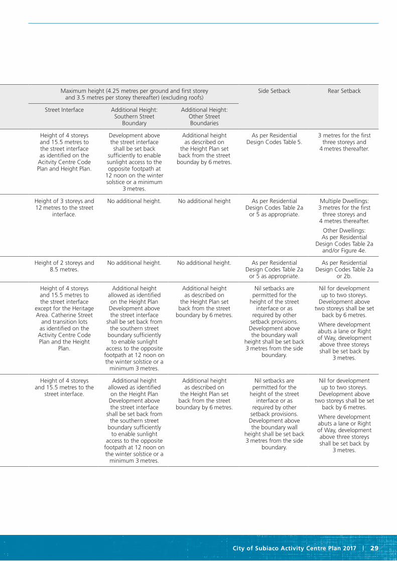
City of Subiaco Activity Centre Plan 2017 | 29
Activity Centre Code R-Code Maximum Plot Ratio Minimum Open Space (% of site)
Street Setback Maximum height (4.25 metres per ground and first storey and 3.5 metres per storey thereafter) (excluding roofs)
Side Setback Rear Setback
Street Interface Additional Height: Southern Street
Boundary
Additional Height: Other Street Boundaries
Residential R160 As per Residential Design Codes Height of 4 storeys and 15.5 metres to the street interface as identified on the
Acitvity Centre Code Plan and Height Plan.
Development above the street interface shall be set back
sufficiently to enable sunlight access to the opposite footpath at
12 noon on the winter solstice or a minimum
3 metres.
Additional height as described on
the Height Plan set back from the street bounday by 6 metres.
As per Residential Design Codes Table 5.
3 metres for the first three storeys and
4 metres thereafter.
Residential R80 As per Residential Design Codes Height of 3 storeys and 12 metres to the street
interface.
No additional height. No additional height As per Residential Design Codes Table 2a
or 5 as appropriate.
Multiple Dwellings: 3 metres for the first
three storeys and 4 metres thereafter.
Other Dwellings: As per Residential
Design Codes Table 2a and/or Figure 4e.
Residential R50 As per Residential Design Codes Height of 2 storeys and 8.5 metres.
No additional height. No additional height. As per Residential Design Codes Table 2a
or 5 as appropriate.
As per Residential Design Codes Table 2a
or 2b.
Town Centre Type ‘A’ and Town Centre Type ‘B’
RAC-0 Development North of Churchill Avenue shall have a plot ratio of 3.
Development South of Churchill Avenue shall
have a plot ratio of 2.5.
0 Nil to the street except for Churchill Avenue where setbacks shall be consistent with the streetscape and
determined by Council, though not more than
4 metres.
Height of 4 storeys and 15.5 metres to the street interface
except for the Heritage Area. Catherine Street
and transition lots as identified on the
Activity Centre Code Plan and the Height
Plan.
Additional height allowed as identified on the Height Plan Development above the street interface
shall be set back from the southern street
boundary sufficiently to enable sunlight
access to the opposite footpath at 12 noon on the winter solstice or a
minimum 3 metres.
Additional height as described on
the Height Plan set back from the street
boundary by 6 metres.
Nil setbacks are permitted for the
height of the street interface or as
required by other setback provisions. Development above the boundary wall
height shall be set back 3 metres from the side
boundary.
Nil for development up to two storeys.
Development above two storeys shall be set
back by 6 metres.
Where development abuts a lane or Right of Way, development above three storeys shall be set back by
3 metres.
Centro and Mixed Use RAC-0 Development North of Hay Street shall have a
plot ratio of 3.
Development South of Bagot Road shall have
a plot ratio of 2.5.
0 Nil Height of 4 storeys and 15.5 metres to the
street interface.
Additional height allowed as identified on the Height Plan Development above the street interface
shall be set back from the southern street
boundary sufficiently to enable sunlight
access to the opposite footpath at 12 noon on the winter solstice or a
minimum 3 metres.
Additional height as described on
the Height Plan set back from the street
boundary by 6 metres.
Nil setbacks are permitted for the
height of the street interface or as
required by other setback provisions. Development above the boundary wall
height shall be set back 3 metres from the side
boundary.
Nil for development up to two storeys.
Development above two storeys shall be set
back by 6 metres.
Where development abuts a lane or Right of Way, development above three storeys shall be set back by
3 metres.
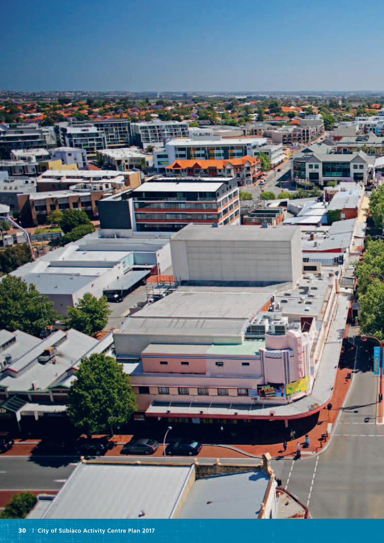
Part one Implementation
30 | City of Subiaco Activity Centre Plan 2017

City of Subiaco Activity Centre Plan 2017 | 31

Part two Explanatory report
32 | City of Subiaco Activity Centre Plan 2017
1.0 Introduction
Subiaco has undergone significant change over the past twenty
years. From a working class suburb with a significant industrial
presence, Subiaco has emerged as a significant metropolitan
destination for dining and shopping as well as a major office
location. Significantly, through the work of the Subiaco
Redevelopment Authority (now the Metropolitan Redevelopment
Authority), the former industrial land has been transformed into a
mixed use live-work precinct, bolstered by the under-grounding of
the Subiaco Train Station and creation of a high quality public realm.
Notwithstanding this significant change, town centres are
dynamic places that continue to grow, adapt and modify to
meet the community’s needs. Particularly for Subiaco, it will face
considerable structural change in the coming years with the
relocation of AFL Football to a new major stadium in Burswood,
the relocation of Princess Margaret Hospital for Children to QEII
Medical Centre and the potential relocation of King Edward
Memorial Hospital for Women to QEII Medical Centre. These
major facilities currently drive and influence the nature of
employment and land uses throughout Subiaco, and so this
Activity Centre Plan will need to consider likely future patterns
of use.
1.1 Project purpose In consultation with the community, the City of Subiaco has
prepared the Subiaco Activity Centre Plan. It provides a long term
planning vision to support the economic and social vitality of the
activity centre as an attractive place to live, work, shop and visit.
The plan provides a framework for the ongoing development and
revitalisation of the town centre, and outlines provisions
for housing, transport, heritage conservation, land use and
urban form.
Activity Centre Plans are required for all centres across the
metropolitan region above a district designation. They inform the
activity, movement, environment and urban form characteristics of
the centre to support improved performance over time.
More than just a statutory planning mechanism, the Activity
Centre Plan can set a vision and framework for ongoing
rejuvenation of Subiaco’s town centre.
In particular, this Activity Centre Plan will:
• Establish a common vision for Subiaco’s town centre and
an intent across its economic, social, environmental and
governance responsibilities.
• Provide guidance on a range of actions to ensure that Subiaco’s
town centre can accommodate development and growth
commensurate with its designation as a Secondary Centre.
• Establish a blueprint for an improved public space network.
• Clearly signal the importance and opportunity of Subiaco as a
Part twoExplanatory report

City of Subiaco Activity Centre Plan 2017 | 33
key employment destination with excellent links to Perth CBD
and the QEII / UWA Strategic Centre.
• Establish the importance of Subiaco within the metropolitan
area and the need for collaborative engagement with the
community to ensure its future development and growth.
• Provide confidence to government, business, and potential
funders and collaborators, that Subiaco has a strong vision and
forward plan to protect future investment.
1.2 Project background
1.2.1 Subiaco Central Development Plan The Subiaco Central Development Plan, prepared in 2006, is
similar to an Activity Centre Plan in that it provides a vision and
a framework for future development by establishing built form
controls and character statements for various precincts. However,
State Planning Policy 4.2 Activity Centres for Perth and Peel
(SPP 4.2) requires additional consideration of elements such as
minimum residential densities, population, employment mix, a
consideration of retail sustainability and land uses in response
to recent State policy - namely Directions 2031 and Beyond
and the Central Metropolitan Perth Sub Regional Strategy. An
activity centre plan is therefore required to consider additional
information and be endorsed by the Western Australian Planning
Commission to ensure broader metropolitan strategies are
appropriately implemented.
1.2.2 Relationship to Subiaco Redevelopment Area The Subiaco Activity Centre Plan acknowledges and responds to
the land use, form and activities within the Redevelopment Area.
This Activity Centre Plan will not apply to the Redevelopment
Area, it having separate scheme and policy provisions under the
Metropolitan Redevelopment Act.
1.3 Requirements of state planning policy 4.2 Activity Centres for Perth and Peel With the introduction of State Planning Policy 4.2 Activity
Centres for Perth and Peel, all town and city centres across the
metropolitan area are required to plan for future growth and
development. Importantly, activity centres are required to provide
a mix of land uses within a high quality setting to enable equitable
service provision to the population. This means activity centres
need to be more than single land use destinations, they need
to function as distinct community spaces where people gather,
work, shop, play and live. The activity centre plan therefore needs
to provide a framework for the future growth and development
of centres, taking into account increased residential densities,
encouraging a mix of commercial floor space and employment
types and allowing for alternative modes of transport, particularly
public transport.
1.4 Subiaco’s place making process Place making is the process of making authentic, vibrant and
resilient places that are valued by their communities and admired
by visitors. It is a holistic, multi-disciplinary approach to planning
and developing places that involves understanding the culture and
qualities of a place and the wisdom of its community. It involves
collaboration between many stakeholders to articulate a vision for
a place and to plan and deliver the vision.
A place making vision workshop was undertaken with key
businesses and community representatives in the City of Subiaco,
in order to seek community input into the development of a new
Subiaco Activity Centre Plan.
The process involved working collaboratively with the project team
and the City of Subiaco to engage with the community of the
Subiaco town centre to explore and document their aspirations
and priorities for the Subiaco Secondary Activity Centre.
The process involved three steps: a background paper, a key
stakeholder and community visioning workshop, and a Draft Place
Vision and Place Making Principles document.
2.0 Vision
2.1 Vision statement
2.1.1 Activity centre vision
Subiaco town centre is the State’s premier knowledge centre, with excellent links to the Perth CBD, University of Western Australia and QEII Medical Centre. Its high quality, green and leafy public realm supports a relatively dense mix of residential, retail, hospitality, cultural and commercial activities. Transit is integrated seamlessly into the heart of Subiaco, enabling commuting access. Heritage and contemporary buildings sit comfortably together to create an intense, exciting, liveable and sustainable town centre.
2.1.2 Place making vision Subiaco town centre is an exciting and contemporary place
balanced with a rich heritage. It is a beautiful, green place with
scale and surprise that is full of great food, art and music.
2.1.2.1 Place making principles• An exciting shopping experience that is renowned for being
filled with skilful, creative and delicious offerings
• A connected, collaborative, diverse community that engages
enthusiastically with the city and what it has to offer
• A place that is founded on the value of environmental
sustainability and which is liveable for the community both now
and in the future
• A balance of old and new where the rich history and the bright
future of Subiaco are both evident and honoured
• A place of creativity and theatre where the streets and
people are as friendly and entertaining as the official events
programmes.
Part two Explanatory report
34 | City of Subiaco Activity Centre Plan 2017
2.2 Strategic overview The following identifies the strategic context underpinning the
preparation of the Activity Centre Plan.
A changing centre
The contextual framework of Subiaco is changing, with the
impending relocation of the Princess Margaret and King Edward
hospitals to the QEII Medical Centre. The relocation of AFL
Football from Subiaco to Burswood will also mean a significant
change in weekly visitor numbers during the season. This means
Subiaco’s point of difference to attract visitors will need to
change focus.
A connected city
An interconnected metropolitan network of centres is envisaged
by the State’s overarching planning strategy – Directions 2031 and
Beyond. Planning for improved public transport and other modal
connections in and around Subiaco will increase its accessibility
to the metropolitan region and thus its competitiveness. In this
regard the Activity Centre Plan will accommodate better public
transport connections.
More people
For Subiaco, improving its performance is mostly about attracting
more people to it – whether that is for living, working, recreating
or spending. State Policy requires the centre area to lift its
average residential density from 13 dwellings to between 25 and
35 dwellings per gross hectare.
Placemaking
The key element to improving the performance of Subiaco is to
build and reinforce a convincing and authentic place. A network
of high quality urban spaces, around which built form and land
uses respond, will support a diversity of experiences for visitors.
These places will provide an impetus for people to stay in Subiaco.
The changing retail landscape
Comparison retail (durable goods) in Subiaco is coming under
increased pressure due to competition from surrounding centres
that offer a similar experience as well as from internet shopping.
This means the attractiveness of Subiaco needs to shift from a
retail offer to a place based and experiential offer.
Activity Centre Plan
Creating an Activity Centre Plan for Subiaco’s Activity Centre,
informed by the desires of the community, allows the City to
shape its own future, rather than responding to external forces.
The Activity Centre Plan must consider land use and activity,
movement, urban form (including a public space network),
and resource enhancement initiatives, that respond to the local
character of Subiaco.
2.3 Strategies
Successful activity centres are defined by their:
• Intensityofactivitiesandpeople;
• Diversityofactivitiesandbusinesses;
• Employmentmix–successfulcentreswillattractbusinesses that require a higher proportion of creative industries;and
• Access–arangeofaccessarrangementswillbeinplace,usually with very high quality public transport as a defining element.
In this regard, six strategic drivers have been developed to improve the performance of Subiaco. They have been developed from community and Council workshops as well as extensive site analysis.
1. An active, intense and diverse town centre
2. A renewed focus for the economy and development
3. Sustainable urbanism that protects Subiaco’s heritage
4. A strong network of high quality public places
5. A prioritised and sustainable transport network
6. A governance framework to support growth and change
2.3.1 An active, intense and diverse town centre To ensure Subiaco develops as a more active, intense and diverse
town centre, the over-riding principle is to attract more people
to it – more residents, more workers, more shoppers and more
visitors. Analysis shows that Subiaco currently performs above
the metropolitan average in terms of intensity of employment and
diversity of commercial land uses. However, it is underperforming
in terms of residential dwellings as well as in terms of its
comparison retail floor space. Critical to Subiaco’s future will
be how it responds to the changing economic landscape, when
major health institutions and AFL football are no longer within its
catchment. The implications of this changing economic landscape
for Subiaco are potentially negative for retail and entertainment
land uses in particular.
Comparison retail
Comparison Retail are goods that consumers ‘shop around’ for.
They are bought on an irregular basis (e.g. Households goods,
clothing, motor vehicles). Comparison retail is currently under-
trading in Subiaco, providing an opportunity to activate vacant
retail premises along Rokeby Road and Hay Street.
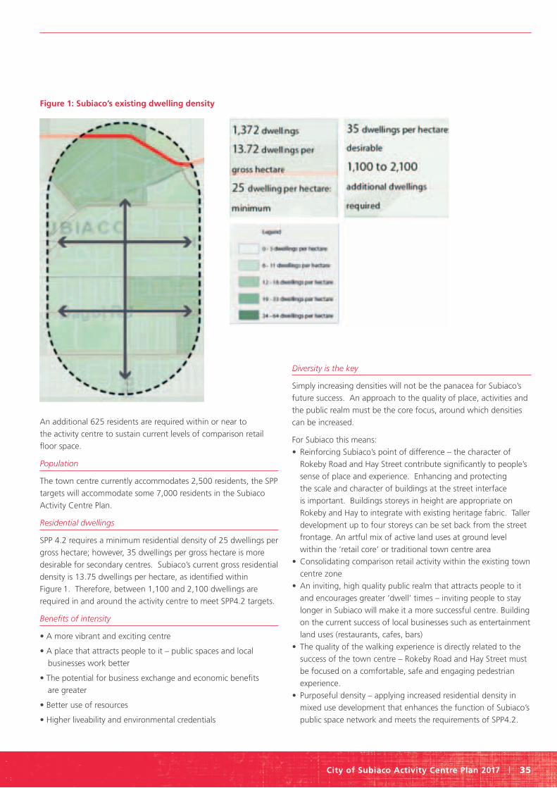
City of Subiaco Activity Centre Plan 2017 | 35
An additional 625 residents are required within or near to
the activity centre to sustain current levels of comparison retail
floor space.
Population
The town centre currently accommodates 2,500 residents, the SPP
targets will accommodate some 7,000 residents in the Subiaco
Activity Centre Plan.
Residential dwellings
SPP 4.2 requires a minimum residential density of 25 dwellings per
gross hectare; however, 35 dwellings per gross hectare is more
desirable for secondary centres. Subiaco’s current gross residential
density is 13.75 dwellings per hectare, as identified within
Figure 1. Therefore, between 1,100 and 2,100 dwellings are
required in and around the activity centre to meet SPP4.2 targets.
Benefits of intensity
• A more vibrant and exciting centre
• A place that attracts people to it – public spaces and local
businesses work better
• The potential for business exchange and economic benefits
are greater
• Better use of resources
• Higher liveability and environmental credentials
Diversity is the key
Simply increasing densities will not be the panacea for Subiaco’s
future success. An approach to the quality of place, activities and
the public realm must be the core focus, around which densities
can be increased.
For Subiaco this means:
• Reinforcing Subiaco’s point of difference – the character of
Rokeby Road and Hay Street contribute significantly to people’s
sense of place and experience. Enhancing and protecting
the scale and character of buildings at the street interface
is important. Buildings storeys in height are appropriate on
Rokeby and Hay to integrate with existing heritage fabric. Taller
development up to four storeys can be set back from the street
frontage. An artful mix of active land uses at ground level
within the ‘retail core’ or traditional town centre area
• Consolidating comparison retail activity within the existing town
centre zone
• An inviting, high quality public realm that attracts people to it
and encourages greater ‘dwell’ times – inviting people to stay
longer in Subiaco will make it a more successful centre. Building
on the current success of local businesses such as entertainment
land uses (restaurants, cafes, bars)
• The quality of the walking experience is directly related to the
success of the town centre – Rokeby Road and Hay Street must
be focused on a comfortable, safe and engaging pedestrian
experience.
• Purposeful density – applying increased residential density in
mixed use development that enhances the function of Subiaco’s
public space network and meets the requirements of SPP4.2.
Figure 1: Subiaco’s existing dwelling density

Part two Explanatory report
36 | City of Subiaco Activity Centre Plan 2017
2.3.2 A renewed focus for the economy and development A successful local economy will inevitably contribute to the
performance of Subiaco as an activity centre. Industries that
exhibit high levels of skill and human capital are likely to
contribute proportionally more to the economy than industries
requiring low skill levels. Industries where information technology,
finance, arts and entertainment and professional services are the
focus tend to require significantly more creative personnel, that
is, people on higher incomes with a greater propensity to spend.
This in turn contributes to the local economy.
For Subiaco this means:
• Access: Integrate mixed land uses around public transport and
improve the pedestrian and cycling experience to and through
Subiaco so as to ensure their priority over the private car.
• Agglomeration Clusters and Talent Magnets: Promote further
development of professional services and information /
technology sectors within Subiaco by preparing an economic
development strategy that recognises, attracts and retains
important organisations that act as talent magnets within
Subiaco (for example, iiNet, Mirvac, RPS, St John of God).
• Floor space: enable development of additional office space
throughout Subiaco to meet sub-regional employment targets.
• Labour Supply and University Talent: Maximise links (public
transport and cycle) between Subiaco and the QEII / UWA
Specialised Centre; promote the development of higher density,
affordable housing within the Subiaco Activity Centre that
enables professionals to live in close proximity to UWA / QEII
• Quality of Public Realm: Develop a high quality network of
public spaces and associated activities throughout the activity
centre that promotes improved quality of living and enables
exchange between professionals
2.3.3 Sustainable urbanism that protects Subiaco’s heritage Higher density living and working opportunities need not come
at the expense of important historic buildings, local character and
liveability. The most successful centres artfully balance
these development factors, demonstrating they need not be
mutually exclusive.
For Subiaco this means:
• That the area identified in the “Assessment of the Rokeby Road
and Hay Street Heritage Area” report (Griffiths Architects, 2013) is
identified as a Heritage Area under the Town Planning Scheme.
• Applying appropriate R-Code density and built form standards
across the centre to enable housing targets to be met – for
identified opportunity sites, a minimum of R100 should be
established, with a desirable level of R160.
• Encouraging minimum standards in terms of design and
environmental quality
2.3.4 A strong network of high quality public places Overwhelmingly, the focus of the Subiaco Activity Centre Plan
is the creation of a series of high quality public places that
reinforce the structural elements of the activity centre and
provide opportunities for place making and development. These
spaces will become neighbourhood hot spots; foci for activity,
engagement and exchange.
For Subiaco this means:
• Enable built form and urban design responses around each
public space area that reinforces quality and functionality, based
on ‘hot spots’ identified through place making workshops.
• Prepare a place activation strategy for each of the identified
public spaces that defines their purpose, a programme of events
and how adjacent traders can contribute and activate the public
realm.
• Encourage a mix of high quality businesses in and around each
public space commensurate with their intended role / function,
such as cafes, bars and shops. The scale and intensity of activity
will vary.
• Improve the quality and comfort of the public realm.
2.3.5 A prioritised and sustainable transport network To enable a successful centre, the priority in terms of transport
provision must be the amenity and comfort of pedestrians. In this
regard, the order of prioritisation for transport in and around the
activity centre must be:
• Pedestrians
• Cyclists
• Public Transport
• Service vehicle accessibility
• Private cars
For Subiaco this means:
• Adopt the ‘power of nearness’ – ensuring a great variety of
land uses, transport and public space options are present within
close walking distance of people.
• The quality of the walking experience is emphasised in every
detail through the public realm. Passive surveillance, active
shop fronts (where required) and built form that addresses the
street is critical.
• Adopt a cycling strategy that provides for routes through and to
Subiaco’s activity centre, ideally with separation between bike
lanes and traffic.
• Development decisions within the Activity Centre will support
the provision of high quality, reliable public transport options.

City of Subiaco Activity Centre Plan 2017 | 37
2.3.6 A governance framework to support growth and change Ensure the new governance model provides clear leadership
and develop partnerships across a range of public, private
and community sectors to help drive awareness of Subiaco’s
activity centre as a major shopping, entertainment, working and
living environment.
For Subiaco this means:
• Incorporate the findings of the Activity Centre Plan study and
community workshops into development provisions within the
city’s new town planning scheme.
• Prepare a detailed place making and public realm strategy for
the town centre.
• Engage / employ a town centre place manager to facilitate
implementation of place making strategies.
• Adopt a flexible approach to consideration of development
proposals so that an intensified activity centre is created,
consistent with place and character principles.
• Communicate the plan widely and encourage support from
external stakeholders.
• Provide an agreed framework to manage the implementation
of the community’s vision for the town centre.
3.0 Centre context
3.1 Regional context
3.1.1 Planning framework This section of the report outlines the important State and local
planning instruments that are relevant to the Subiaco Activity
Centre Plan. No attempt is made to exhaustively examine every
item of legislation or policy; only those most relevant to the study
are considered here.
3.1.1.1 Perth and Peel at 3.5 million. Perth and Peel at 3.5 million is the strategic document prepared
by the Department of Planning and that provides guidance on
sustainable urban growth for the next 35 to 40 years. Subiaco
lies within the Central sub-region which is expected to experience
a population growth from 782,974 people in 2011 to up to 1.2
million by 2050.
3.1.1.2 Directions 2031 and beyond Directions 2031 and Beyond (Directions 2031) is a strategic state
planning instrument that identifies a spatial planning framework
to address the expected population growth of Perth and Peel
regions. Directions 2031 identifies Subiaco town centre as a
secondary centre which is a suburban centre dominated by retail
land use but also includes offices, housing, community services,
recreational activities and entertainment facilities.
3.1.1.3 Central Metropolitan Perth Sub-Regional Strategy
The Central Metropolitan Perth Sub-Regional Strategy (Sub-
Regional Strategy), identifies how the objectives of Directions
2031 will be achieved. The sub-regional strategy has identified
areas for urban infill and expansion across the metropolitan area.
The City of Subiaco has an infill dwelling target of an additional
3,600 dwellings.
3.1.1.4 Capital City Planning Framework The Capital City Planning Framework (Framework), sets out a
spatial strategy for Central Perth, and the 12 km by 12 km area
around the city centre.
The Framework highlights Subiaco as a good example of
urbanism, providing an alternative to suburban development,
CBD high rise.
The Framework identifies eleven key concepts ranging from a
‘city of place’ with urban characteristics, to a ‘city that evolves’.
The Subiaco Activity Centre Plan area demonstrates many of these
key concepts.
3.1.1.5 Public Transport for Perth in 2031 Master Plan The Public Transport for Perth in 2031 Master Plan identifies the
public transport network needed to support Perth’s growing
population and highlights the importance of collating appropriate
land uses and densities with public transport infrastructure.
The Transport Plan identifies the success of sinking the Subiaco
Station and the creation of Subi-Centro in increasing train
patronage. Boardings per day increased from 1,600 before the
development to 3,000 boardings per day in 2010.
The Subiaco to Perth rail link is expected to accommodate some
30,000 to 50,000 passenger trips each day.
The Transport Plan also identifies the importance of delivering a
Glendalough/Subiaco/UWA inner circle link by 2031. It is expected
this link will be serviced by light rail in the future. Subiaco is
identified as an important node in the proposed Stirling, Subiaco,
QEII/UWA, Murdoch, Curtin University, Perth Airport circle link.
3.1.1.6 Transport @[email protected] is a long term integrated transport plan that
addresses the transport needs of Perth and Peel as a City of 3.5
million people and beyond and provides the transport component
to the draft Perth & Peel @ 3.5 million strategy. The plan proposes
improvements to the public transport, road and active transport
networks and includes proposals to optimise the existing system
to more efficiently deal with the increased transport needs of a
growing population.
Improvements for the City of Subiaco include a notional Inner City
Metro, a light rail route linking QEII/UWA with Curtin University
via Subiaco and the Perth CBD, and a new heavy passenger rail
link connecting Murdoch with Stirling via QEII/UWA and Shenton
Park as part of an orbital rail link.

Part two Explanatory report
38 | City of Subiaco Activity Centre Plan 2017
There are no road proposals that directly affect the City of
Subiaco. However, a proposed extension to Stock Road through
the Western suburbs is expected to attract additional traffic
through the City.
3.1.1.7 StatePlanningPolicy4.2–ActivityCentresforPerthand Peel The State Planning Policy 4.2-Activity Centres for Perth and Peel
(SPP 4.2) guides development of new activity centres and the
redevelopment and renewal of existing centres in the Perth and
Peel regions.
The characteristics of a secondary centre addressed in the Subiaco
Activity Centre Plan are:
• Function – operates as a small scale metropolitan centre
offering services, facilities and employment.
• Transport – provides passenger rail and high frequency bus
routes.
• Land use – includes department stores, discount department
stores, supermarket, and speciality shops, complemented by
office land use.
• Service – centre will service up to 150,000 persons.
• Walkable catchment – centre based on a 400 metre catchment.
• Residential density – A minimum of 25 dwellings per gross
hectare, desirable target of 35 dwellings per gross hectare. (The
SPP4.2 density target takes precedence over the sub-regional
strategy density target)
The Subiaco Activity Centre Plan area has many of the
secondary centre characteristics. There is a diversity of land
use within the town centre, the majority of Subiaco’s retail,
recreational, and medical services are located within the 400
metre walkable catchment and there are opportunities for
improved public transport.
3.1.1.8 Transit oriented development The Development Control Policy 1.6 Planning to support Transit
Use and Transit Oriented Development (DC1.6) complements a
range of planning policies to achieve greater urban sustainability.
The objectives of TOD are:
• Maximise walkability to destinations and transit via logical
connections
• Maximise safety to encourage visitors
• Minimise the number and duration of private vehicle trips
• Provide public and private car parking in a strategic manner
• Enhance activity levels across the day and night
The urban form of the Subiaco Activity Centre Plan area displays
TOD elements such as:
• A grid street pattern
• Diversity of lot sizes
• Development opportunities
• Close proximity to transit
• Diversity of land use
3.1.1.9 Metropolitan Region Scheme The Metropolitan Region Scheme (MRS) is a statutory State
Government planning instrument which broadly guides the
distribution of land use throughout the Perth metropolitan area by
designating ‘zones’ and ‘reserves’.
Subiaco Activity Centre is generally zoned ‘urban’ and provides for
retail, residential, and commercial land uses.
The MRS reserved land within and surrounding the Subiaco
Activity Centre plan area:
• King Edward Memorial Hospital, reserved for Public Purposes:
Hospital
• The Perth to Fremantle railway, located to the north and west of
the activity centre, is reserved for ‘Railways’.
• Hay Street and Thomas Street are reserved as ‘Other Regional
Roads’ with the exception of land between Hay Street and
Railway Road, and Hay Street and Troy Terrace; which is zoned
‘Redevelopment Scheme’.
Figure 2 Figure 3 Figure 4

City of Subiaco Activity Centre Plan 2017 | 39
• Perth Modern School, to the north west of the activity centre is
zoned ‘Public purpose – high school’.
• Subiaco Oval, located to the north east of the activity centre is
reserved ‘Restricted public access’.
The Redevelopment Area controlled by the Metropolitan
Redevelopment Authority is not affected by the MRS. When these
areas are normalised back to the City of Subiaco, they revert to
the urban zone or appropriate reservation.
3.1.2 Strategic opportunities and challenges
3.1.2.1 Conceptual understanding of subiaco’s future Figures 2, 3 and 4 contains conceptual representation of
Subiaco’s context, both now and in the future. Subiaco has
relationships with surrounding centres that are of a different
typology and function - Perth and QEII.
Figure 2 shows Subiaco (in orange) surrounded by a number of
institutions that influence its activity and character:
• Subiaco Oval
• King Edward Memorial Hospital (KEMH)
• Princess Margaret Hospital (PMH)
• St John of God Hospital
The nearby centres of Perth and QEII / UWA also have significant
influence on Subiaco.
Figure 3 represents the potential future scenario for Subiaco.
PMH and potentially KEMH are to be relocated to the QEII Medical
Centre and Subiaco Oval will potentially be downgraded with
AFL Football moving to Perth’s new stadium at Burswood. A new
light rail link between the city and QEII Medical Centre will change
travel behaviour through Subiaco.
This represents a fundamental structural change to Subiaco’s
character, function and economy.
Figure 4 is a conceptual representation of the need to bolster
the town centre in order to create a viable and sustainable land
use mix. This activity centre plan will need to identify the form
and function of the town centre to define a sustainable future.
This may be achieved by also bolstering the strategic location of
Subiaco between the key activity centres of Perth city and QEII /
UWA.
Importantly, Subiaco will need to capture the benefits of its
specialities, namely health, hospitality and entertainment, its
commercial office presence and its village character. Balancing
these uses is important.

Part two Explanatory report
40 | City of Subiaco Activity Centre Plan 2017
A high quality environment
A high quality public realm and amenity across Subiaco town
centre attract businesses. Residential areas have a pedestrian scale
environment, good access to parks and conveniences.
The ‘third place’
Commerce and business is now conducted more often in semi-
public places like cafes and restaurants than in traditional office
setting. Subiaco’s mature mix of these activities attracts and
retains businesses and employees.
Smart communities
A smart community circulates people, products and ideas quickly
and efficiently.
Smart communities are:
• Globally Connected - UWA and QEII offer opportunity for better
communication infrastructure, transport links and a strong
global identity
• Regionally Networked - Strong physical, social, transport and
digital connections promote seamless integration. Research and
development activities need infrastructure and support.
• Places for People - LIfestyle quality attracts knowledge workers.
An active and interactive lifestyle is supported by and promotes
public life and celebrates our climate and outdoor way of living.
Shaping the urban environment
The following need to be achieved in order to make an urban
environment a smart community.
• Co-location of key anchor uses to generate synergies.
• Provision of shared work facilities and public spaces to support
interaction and incidental meetings.
• A walkable public realm that is linked with reliable and frequent
public transport.
• Travel distances between the home and work place are
shortened or co-located.
• Better work life balance, supporting integrated activities and
social interaction.
• A high quality, mixed-use environment providing a range of
community facilities for various users.
Figure 5

City of Subiaco Activity Centre Plan 2017 | 41
• A mix of people and experiences to attract and retain
knowledge workers.
• A low crime rate and security for use by all citizens, supported
by increased numbers of pedestrians and good public
surveillance.
Translating to the urban context
The proposition for smart communities is to create environments
that support interaction between knowledge workers in the
physical realm. The location of facilities and activities in the public
realm creates opportunities for interaction. The success of these
places will depend upon their utility, authenticity, diversity and
richness.
3.1.3 Subiaco’s opportunities and challenges (SWOT) Subiaco Activity Centre has a number of strengths, weaknesses,
opportunities and threats in the short and medium term. Key to
the success of the plan will be the ability to turn the weaknesses
and threats into opportunities and then strengths.
The strengths of Subiaco Activity Centre are:
• The current maturity of the centre resulting from the long
history of the centre;
• The key infrastructure and major regional attractors;
• The strong and affluent resident community and business
advocacy groups.
The weaknesses of Subiaco Activity Centre are:
• Disappearing regional drivers such as the stadium and PMH;
• Poorly connected to major road networks, limiting passing trade
to the centre; and
• The current downturn in comparison retail demand.
The opportunities identified for Subiaco Activity Centre are:
• Redevelopment potential of a number of key sites;
• The development of UWA-QEII, PMH and Subiaco Oval may
present opportunities to develop service businesses for this
centre;
• Reinforce and encourage active and public transport use to
optimise centre expansion;
• Large sewer and water mains. Use State Government’s
guidelines to develop water efficiency policies.
• Adequate existing drainage infrastructure. New regulators to
decrease stormwater.
• National Broadband Network rollout in the Subiaco area
commenced in June 2013.
The threats identified for Subiaco Activity Centre are:
• Stagnation of centre maturation may result in businesses
choosing to locate in competing centres;
• The lack of a defined, agreed vision may act as a barrier to
future development;
• Increased competition from other centres to attract businesses;
• Online shopping and the deregulation of retail trading hours
introduce greater competition for retailers;
• Retaining the ‘village scenario’ can result in a contraction of
retail floorspace and will require new drivers to sustain the
centre;
• The gas pressure network may require reinforcement in the
future.
• Potential construction of a new transformer in Subiaco may
impact on future development.
3.1.4 Centre hierarchy: secondary centre A secondary centre shares similar characteristics with strategic
metropolitan centres but serve smaller catchments and offer
a more limited range of services, facilities and employment
opportunities. They perform an important role in the city’s
SPP 4.2 identifies a
few very high-level
measures of activity
centre performance.
The metrics in Table 4
have been developed
for more accurate
assessment of activity
centre performance.
Subiaco Activity
Centre is expected to
perform at a relatively
high level across all
categories.
Table 2. Subiaco Activity Centre Targets

Part two Explanatory report
42 | City of Subiaco Activity Centre Plan 2017
Table 3. Activity centre performance metrics
Area Metric Explanation
Economic Sustainability Diversity Mixed use threshold and equitability index
Intensity Residential density and job density
Employment Quality Employment quantum and employment quality index
Accessibility Transport infrastructure and distance from CBD
Urban Form Urban Quality Attractive and unattractive features
Urban Amenity Comfort, noise levels, recreational and social infrastructure
Mobility Infrastructure facilitating pedestrian movement, cycling, public transport
and private vehicle movement
Safety Traffic safety indications, safety perception indications and crime statistics
Table 4 shows the current economic sustainability score for the Subiaco Activity Centre compared to other similar centres across Australia.
Table 3. Current economic sustainability score *
Economic Measure Subiaco Activity Centre Average Inner Urban Best Inner Urban
Diversity 6.50 7.00 8.70
Intensity 8.20 6.65 9.20
Employment Quality 8.25 7.75 9.50
Accessibility 8.50 8.25 8.50
Overall score 8.01 7.41 8.98
* Current Economic Sustainability Score: The application of strategies to optimise the use of existing resources in order to achieve a responsible and beneficial balance in the long-term. In the context of the City of Subiaco this incorporates planning measures that efficienctly use its comparative advantages in order to provide long-term socio-economic benefits. Source: Pracsys 2012
Table 5. Current urban form score **
Metric Subiaco Activity Centre (WA)
Booragoon Secondary Centre (WA)
Cannington Secondary Centre (WA)
Norwood Main Street (SA)
Marion Shopping Mail (SA)
Urban Quality 5.8 5.1 4.1 5.5 3.7
Urban Amenity 8.3 3.6 2.8 8.0 7.3
Mobility 6.9 4.5 6.0 5.4 4.9
Safety 7.4 6.1 7.3 7.7 6.2
Aggregate Score 7.1 4.8 5.1 6.6 5.5
** Urban Form Score: Provides a normative scoring mechanism to assess an activity centre’s urban form and is based on four criteria: Urban Quality, Urban Amenity, Mobility and Safety. This scoring mechanism was used to assess the Subiaco Activity Centre in terms of the quality of its design, the level of amenity provided, its accessibility and the degree of safety for users. Source: Pracsys 2012

City of Subiaco Activity Centre Plan 2017 | 43
economy, and provide essential services to their catchments. A
secondary centre has an indicative service population (trade) area
of Up to 150,000 persons and a walkable catchment of 400m.
The Subiaco Activity Centre is expected to move towards meeting
the targets set out in Table 2 on the previous page.
Subiaco Activity Centre performs relatively high across most
metrics. Unlike the two Western Australian secondary centres
used as a comparison, Subiaco is not focused on retail but include
other types of land uses, such as office and health-related uses.
Given the trends and expected future changes, it is important to
improve the place experience and diversity of goods and services.
The influx of residents into the core and periphery of the activity
centre increase the intensity of the centre and goods and services
demand for inner-city living.
3.1.4.1 Centre targets
Residential density
SPP 4.2 requires average gross densities of between 25 and 35
dwellings per hectare. Within the boundary of the activity centre,
the current gross residential density is 10 dwellings per hectare.
Large institutions such as the King Edward Memorial Hospital lower
this number. Removing these from the overall calculation, and
considering a broader catchment around the main spine of Rokeby
Road, the gross residential density is 13 dwellings per hectare.
An additional 1,100 to 2,100 dwellings are required to meet SPP
4 .2 targets.
3.1.5 Subiaco’s main trade area
The main trade area catchment is shown in Figure 6. The
catchment map shows where the majority of the Subiaco activity
centre’s users reside.
3.2 Local context
3.2.1 Centre boundary
Subiaco’s Activity Centre Plan boundary was defined through
a consultative approach. The boundary line considers the key
area of focus and intensity of activities relating to the existing
town centre;
• A walkable catchment from the activity spine of Rokeby Road
and supporting activity on Hay Street and Bagot Road;
• A mix of existing land uses to ensure appropriate diversity
of activity
• A desire to concentrate activity within Subiaco’s existing
town core.
A separate planning and urban design study is being progressed
for the North Subiaco Structure Plan area, providing guidance for
redevelopment opportunities to the east along Hay Street or south
on Rokeby Road, outside of the Subiaco Activity Centre.
3.2.2 Demographic profile and defining characteristics
3.2.2.1 Resident population
17,574 people were living in the City of Subiaco (Census 2011),
representing a 7.3% increase in population from 2006. This is
lower than the population growth of Western Australia over the
Figure 6: Subiaco’s trade catchment
Part two Explanatory report
44 | City of Subiaco Activity Centre Plan 2017
same period (14.3%). Population growth in Western Australia’s
occurred in greenfields developments on the urban fringe, rather
than urban infill. According to forecasts in WA tomorrow, Subiaco
is expected to grow to a total population of 21,050 by 2016 (in
accordance with median forecast Band C).
3.2.2.2 Age profile
The median age in the City of Subiaco is 35 years. The largest
proportion of people consist of the 20-24 years and 25-29 years
age groups, at 10.3% and 10.5% respectively. These figures are
higher than the State and national averages for the same age
groups of 7.1% and 7.5% (WA) and 6.8% and 7.0% (Australia).
Subiaco currently has a higher proportion of people 55 years and
above compared to the rest of WA (+2%). This indicates that in
future there could be a need for increased aged care facilities
and appropriate access and amenity should be included in
planning strategies.
3.2.2.3 Household size and composition
Non-family, single person households make up a significant
proportion of the total households in the City of Subiaco (36.9%).
This may reflect the close proximity of the University of Western
Australia (UWA), and a high student population in the City of
Subiaco. Two of the five UWA residential colleges are located
within the City, accommodating an estimated 1,000 students.
3.2.2.4 Dwelling types
The majority of the occupied real estate in the city are separate
houses (41.9%), well below the State proportion of 80.4%. The
proportion of flats, units or apartments in the city (35.4%) was
well above the State average (7.9%). This higher density land use
is due to the city’s close proximity to the Perth CBD.
The proportion of one and two bedroom homes was also
substantially higher in comparison to Western Australian averages.
Three and four bedroom houses formed a lower proportion of
total occupied dwellings.
3.2.2.5 Demographics implications
The analysis of social factors shows a number of trends in the City
of Subiaco:
• The high proportion of young residents is likely to continue
due to the presence of UWA within the city, which may result
in increased demand for consumer services such as small bars,
cafes and other social amenities, as well as innovative land uses.
• Increase in older resident’s proportion as the population ages
and if housing affordability remains unchanged.
The dwelling type mix is expected to comprise an increasing
amount units and apartments.
3.2.3 Existing land use profile
3.2.3.1 Health functions
Subiaco has a strong focus in the health sector, with several
hospitals being located inside its local government boundary. The
activity centre area (and certainly Rokeby Road) contains retail and
hospitality land uses which support the functions of the health
community. Doctor’s surgeries and physiotherapy clinics tend to
be located within and around PMH and St John of God Subiaco
due to the locational advantages and affordability factor. The
health activities located within the shopping areas are pharmacies
and some dentists.
3.2.3.2 Hospitality
Cafes, restaurants bars and pubs are located within Subiaco
centre along Rokeby Road and Hay Streey. In fact, 73% of these
land uses are located within a 400 metre walk of Subiaco train
station. The Regal Theatre and Ace Cinema complex are notable
entertainment functions. Subiaco Oval and the nearby office
precinct support Subiaco’s hospitality sector. Subiaco’s hospitality
sector will be tested if AFL Football moves to the new stadium at
Burswood, expected to be in 2018.
3.2.3.3 Retail intensity
There is a strong retail presence along Rokeby Road and for a
short distance east of the Hay Street intersection. Retail activities
include local boutiques and shops, with a number of national
and international boutiques recently introduced. Retail presence
around the Subiaco Train Station has recently increased.
Subiaco does not contain a large shopping centre. Centres such
as Crossways and The Colonnade demonstrate the importance of
the street interface in providing for viable retail floor space.
3.2.3.4 Supermarkets and department stores
There is a good arrangement of supermarkets along the key
Rokeby Road spine, which help to ‘book end’ retail activity along
Rokeby Road. Nearby centres such as Claremont, Karrinyup,
Stirling and Perth, provide for discount or full line department
store services, creating competition amongst centres.
3.2.3.5 Commercial office development Office development around Subiaco Train Station and the
smaller offices located in former dwellings provide employment
in Subiaco, improving trade opportunities for shops, cafes,
restaurants and other similar land uses.
There are three office precincts within Subiaco. The southern
Rokeby Road with professional service businesses, the Hay Street
precinct with a mix of office space and showroom development
and the redevelopment area with larger mixed use buildings.
3.2.3.6 A main street typology The walkable catchment around the train station and the
containment of a mix of land uses in the town centre create a
concentration of activity along Rokeby Road and Hay Street.
The destinations located along the Rokeby spine form focal points
for surrounding activity. Rokeby Road can be considered in three
main sections,

City of Subiaco Activity Centre Plan 2017 | 45
• Upper Rokeby Road: Coles and Crossways Shopping Centre,
with activity focused on the street
• Lower Rokeby Road: The intersection of Rokeby and Hay; the
Regal Theatre and Subiaco Hotel
• Subiaco Square: The train station and Woolworths with good
pedestrian links to St John of God Hospital and Subiaco Oval
Residential pattern of development limits the ability for
commercial / town centre functions to extend beyond these
key activity corridors. Infill development is required to achieve
State targets.
4.0 Movement
4.1 Regional perspective
The Subiaco Activity Centre is serviced by a localised road network
with the exception of Hay Street that is a dedicated ‘Other
Regional Road’ (ORR). The City of Subiaco and Department of
Planning have shared responsibility for the management of this
road. In the west of Perth’s CBD, the regional road network
contains major roads connecting to the Perth CBD (eg Thomas
Street, Hay Street, Grantham Street and Aberdare Road) but there
are no major north-south routes connecting these ORRs.
A review of historical traffic data in and around the study area
has indicated a strong trend towards low or no growth in traffic
volumes on key roads through the centre of Subiaco. As a result,
a traditional approach to transport planning where a per annum
growth rate is applied to forecast future traffic volumes on the
road network is not considered appropriate.
4.1.1 Strategic road hierarchy
The Main Roads Metropolitan Road Hierarchy (MRH) shows
Roberts Road, Salvado/Railway Parade and Hay Street as
‘Distributor A’ roads. Bagot Road, Rokeby Road, and Nicholson
Road are designated ‘Distributor B’ roads. The remaining streets
are designated as Local Distributor or Access Roads. The MRWA
guidance on these road categories results in characteristics that
are at odds with the intent of the structure plan.
4.1.2 Roberts Road and Hay Street Roberts Road and Hay Street form what is referred to as a
one-way couplet. As noted, Roberts Road and Hay Street are
‘Distributor A’ roads in the MRWA hierarchy. However, in the
Department of Transport’s Smartroads strategic planning of the
metropolitan area, neither route is categorised as a ‘preferred
traffic’ route, which would suggest some inconsistency. The basic
criteria for ‘Distributor A’ Roads include: 60 – 80km/ hour speed
limit, ‘generally’ no parking and clearways where necessary and
preference for service roads to provide access to residential and
commercial properties.
These guidelines are inconsistent with the intent of these roads,
particularly given that the City of Subiaco plans to convert the
one-way couplet to two way streets. There has been research
undertaken in the US that demonstrates the merits of converting
one-way couplets to two way streets from an urban form and
amenity perspective. Key benefits include providing more direct
property access and reducing kilometres travelled.
The City of Perth is progressively converting Hay and Murray
Streets to two way traffic flow and Wellington Street is already
a two way road. A number of other roads have been converted
to two way within the City since 2013. This changing context
therefore supports the potential conversion of Roberts Road and
Hay Street to two-way operation.
4.1.3 Centre arrival points
Arrival points to the centre are important as they give a signpost
to the traveller that they have arrived in a centre and indicate the
transport conditions that they can expect to experience. Based on
a review of current travel characteristics the main arrival points
are: Subiaco Rail Station, Hay Street, Rokeby Road (Salvado Road).
The desired characteristics for these locations are:
• Clear identification signage (i.e. street names) and wayfinding
to car parking and key attractions
• Distance and journey time markers for pedestrians and cyclists
to end of trip facilities and key attractions
• Visual cues that you are entering a slower speed and pedestrian
friendly environment through pavement treatments, tighter
curve radii and streetscape elements (eg landscaping) giving a
perception of a narrower streets.
4.2 Integrated transport planning
As the City of Subiaco grows it is important that there is an
effective integration of development opportunities with transport
options. The challenge is to expand the travel choices of residents,
business owners and visitors to Subiaco, providing convenient
ways to integrate with the regional transport opportunities.
To achieve an integrated approach the City of Subiaco will focus
on initiatives that connect the activity centre with other key
destinations within the City and more broadly. It will prioritise
convenient, active and public transport options to meet increases
in travel demand that population growth will generate. The City
will encourage transit-oriented development that is well serviced
by all modes of transport, and it will be possible to live in Subiaco
without reliance on private vehicles.
As a commitment to integrated transport planning the City will
develop a Transport, Access and Parking Strategy that will inform
the preparation of Town Planning Scheme No. 5, and the review
of the Cities Integrated Transport Strategy and Bike Plan.
4.3 Public transport
4.3.1 Subiaco station
Subiaco Station experiences approximately 7,000 boardings and
alightings on a typical weekday (Smartrider data, February 2016).
Part two Explanatory report
46 | City of Subiaco Activity Centre Plan 2017
The model for this train station, and others on the Fremantle line,
differs markedly to those on the Mandurah and Joondalup lines
where a high number of passengers access the stations via private
vehicle. Subiaco Station is a prime example of a station that has
integrated with the surrounding land use as part of a holistically
planned Transit Oriented Development. Most passengers access
the station by foot and bus due to the limited parking supply that
services the station.
Subiaco Station’s successful patronage can be attributed to three
key factors: the mixed land use surrounding the station, higher
residential densities and the integration of surrounding land use
with the station. A further opportunity to improve access to the
station, particularly by foot, as part of the structure planning
includes installation of real-time train departure board on Rokeby
Road south of Roberts Road. This could encourage train users to
wait for trains while enjoying Rokeby Road rather than waiting on
the station platform.
The Public Transport Authority (PTA) is currently undertaking a
Station Access Strategy for Subiaco Station as part of the PTA’s
Route Utilisation Strategy. The Station Access Strategy would
support and advise any changes to encourage mode share
prioritised in the order of walking, cycling, public transport, then
private vehicle travel when accessing the Subiaco Station..
4.3.2 Future light rail The wider transport network in Perth is expected to change
significantly by 2050 due to projected population increases and
increased public transport use. Potential new movement corridors
between major non-CBD centres are becoming evident – the most
relevant being connections between Stirling, Murdoch, Subiaco,
UWA, QEII and Curtin University.
The Perth Transport Plan has identified that Perth Light Rail will
provide an inner orbital link, connecting UWA-QEII, via the
central and eastern CBD, Victoria Park and Curtin-Bentley to
Canning Bridge.
While there is no identified committed to light rail and bus rapid
transit proposals within the Subiaco Activity Centre, the City has
demonstrated support for light rail by making a number of design
decisions. The activity centre plan has been based on the ability to
integrate light rail within the town centre in the future. The City
would work collaboratively with the Department of Transport to
manage impacts on the Rokeby Road and Hay Street streetscapes
if and when this opportunity was to eventuate.”
The City will prepare a Transport, Access and Parking Strategy
which will further explore the high level proposals within the
Perth Transport Plan and ensure that the development of further
detailed plans for these projects reflect the movement patterns of
people to, from, and within, the City of Subiaco.
4.3.3 Bus services and connections to UWA / QEII knowledge centre The Subiaco activity centre is serviced by four bus routes.
The functions and future opportunities for these services are
described below:
• 97: Subi Shuttle. This service connects the Subiaco train station
with the QEII Medical Centre and UWA Knowledge Centre. It
runs at approximately a 15 minute frequency across the day and
no longer operates on weekends and public holidays (as of 8th
November 2015). As of the 21 March 2016, the 97 bus route
will be extended to Leederville Station during peak periods
• 28: East Perth to Claremont Station (via HBF Stadium): This
service connects between Claremont Station and Hale Street
via Subiaco activity centre. This service operates hourly outside
peaks on weekdays, hourly on Saturdays and on Sundays.
• 27: East Perth to Claremont Station (via Lemnos Street and
Bagot Road): This service connects between Claremont Station
and Hale Street via Subiaco activity centre. This service operates
as frequently as 10 minutes during peaks but at other times
across the day it operates hourly. Again, this service runs
infrequently on weekends and evenings (approximately hourly).
• 25: this service operates at the periphery of the centre, on
Hamersley Road. This service also operates between East Perth
and Claremont Station but accesses the City on Kings Park
Road. This service operates on a small stretch of Thomas Road
where it experiences delays during peak periods. This service
operates as frequently as 20 minutes during peaks on weekdays
but hourly on Saturdays and hourly late weeknights and does
not operator on Sundays.
Recent trends have been towards bus services running less
frequently on weekends due to a decreased demand. The PTA
Station Access Strategy will provide recommendations on bus
priority and bus accessibility to encourage use. There is clearly
room for buses to provide a greater service frequency to Subiaco,
in line with its role as a retail, dining and entertainment hub.
Feedback from the community, in the preparation of the Subiaco
Parking Study, showed support for a Central Area Transit (CAT)
style service similar to those that operate in the Perth CBD,
Joondalup and Fremantle. Key features of a CAT style services
are that they run on a frequency basis (not timetabled), have
distinctive livery and are smaller vehicles designed for a high
turnover of passengers (ie more standing room and easy access to
hasten boarding and alighting).
There is currently no bus priority in place in the Subiaco activity
centre and no specific bus priority projects are currently being
investigated by the PTA in the centre. The main possibility in the
centre is the intersection of Station Road/ Roberts Road/ Rokeby
Road. While there is potential for a ‘bus only’ lane on the Station
Street approach to Roberts Road and on Roberts Road itself,

City of Subiaco Activity Centre Plan 2017 | 47
there is only one departure lane on Rokeby Road so there is no
opportunity for a bus only lane that would allow buses to turn
from Roberts Road. However, one opportunity is to allow buses
only to exit Station Square (currently in-only) directly into Rokeby
Road. This should be explored as part of the potential conversion
of Roberts Road to two-way. Other opportunities for priority for
buses that service the centre but experience delays outside
the centre is the 25 service which travels on a small stretch of
Thomas Road.
The 97 service provides a linkage function between the east-west
bus services that operate through Subiaco. A review of existing
bus stop locations highlights that the location of the 97 service
bus stops are not well integrated, spatially, with the stops on
Bagot Road (number 27 service). Relocating the stops for the
27 service on Bagot Road closer to Rokeby Road could help to
address this.
4.4 Pedestrian movement and cycling
4.4.1 Cycle network Subiaco is generally well serviced by cycling infrastructure;
however, most of the formal cycle infrastructure is geared towards
travel through Subiaco rather than ‘to’ Subiaco as a destination.
A principal shared path (PSP) runs adjacent to the rail line and
connects with a number of east-west road riding environments.
There is however no PSP or other shared path north-south
through Subiaco which links the PSP and importantly links the
station with QEII and UWA. The north-south routes designated in
the Perth Bicycle Network are on-street environments. This does
not suit riders of all abilities.
The preferred location for this north-south shared path route is
parallel to Rokeby Road. To incorporate cycle lanes on Rokeby
Road and to meet relevant design standards would require the
removal of parking, removal of the median or reducing the
width of the footpaths. None of these measures are conducive
to the strategic drivers within the structure plan. A high level
analysis suggests that a north-south shared path is unlikely to
be accommodated within the study area unless street parking is
removed.
4.4.2 Key pedestrian focus areas
4.4.2.1 Relationship to public space network As the centre grows into a place to live and work, considerations
of residential development density and access to quality open
spaces will become even more important. Strategies to achieve
this could include installation of distance marker signs to all open
space for key landmarks.
4.4.2.2 Rokeby Road (pedestrian characteristics) Rokeby Road is the busiest pedestrian street environment in
Subiaco. Key features of the pedestrian environment include:
• Shelter provided by shop awnings and streets trees, providing a
comfortable year-round environment for pedestrians
• Buffer provided between footpath and moving vehicular traffic
through kerbside parking
• Continuous footpaths without a proliferation of driveways and
crossovers
• Staged crossings made possible by the median
• An active pedestrian environment with shop fronts providing
visual interest and passive surveillance – reduces the perception
of journey time
Strategies to improve the pedestrian environment could include:
• The installation of formal pedestrian crossings where
pedestrians have priority. Potential locations for these crossings
could include Churchill Avenue/ Forrest Walk and Park Street.
Detailed investigations would need to be undertaken with
MRWA as there are strict warrant guidelines that apply.
• As the number of bus users increases, allowing space for
passengers to wait for buses clear of through foot traffic will
be important. Careful consideration of these public transport
users and alfresco dinning opportunities should form part of
development approval considerations.
• Provision of way finding signage as they relate to laneways and
connections to car parking opportunities.
• Improvement of laneway aesthetics, potentially including a
public art programme to improve the visual appeal of the
laneways.
• Activate the laneways with pop-up businesses, events
and experiences that would improve passive surveillance
opportunities.
• All interventions should take into account universal access
requirements and Crime Prevention Through Environmental
Design (CPTED) guidelines but also wayfinding, amenity and
‘interest’ characteristics.
4.4.2.3 Hay Street (pedestrian characteristics) Hay Street shares some quality pedestrian characteristics with
Rokeby Road but is generally a poorer environment due to:
• Lack of median and the inability to undertake staged crossings.
11,000 to 18,000 vehicles per day travel on Hay Street
• High occurrence of driveways/ crossovers and side streets
providing potential conflict points between vehicles and
pedestrians
• Discontinuous shelter
• Lack of buildings that consider active frontage
Strategies to improve the pedestrian environment could include:
• Reducing the width of the parking lanes to widen footpaths
and provide cycle lanes under the two-way conversion.
• Regulating the introduction and use (eg number of parking
bays) of crossovers according to the pedestrian characteristic of

Part two Explanatory report
48 | City of Subiaco Activity Centre Plan 2017
the frontage road. A similar strategy is in place under the Perth
Parking Management Act where streets in the CBD are given a
pedestrian classification according to how busily trafficked (foot
traffic) the street or section of street is. This should apply to
other locations within the structure plan where the pedestrian
environment is to be preserved.
• More mixed use development to encourage activity and
therefore passive surveillance.
• Design guidelines that require awnings for new developments.
• Provide opportunities for Hay Street to be the main public
transport route.
4.4.2.4 Station Square (pedestrian characteristics) Station Square is a pedestrian friendly environment that centres
on the station. While the environment is shared with local
traffic, buses, taxis and bicycles, key attributes that enhance the
pedestrian environment include the low speed and volume traffic
environment, quality of pavement treatments and street furniture,
mixed use development, activity created by the station and
covered walkways.
4.5 Local traffic Accessibility and property access for local traffic remains an
important consideration for the City. Walking and cycling
should be encouraged for local trips (i.e. trips with an origin and
destination inside the activity centre). Design elements at all scales
(network connectivity, provision of bicycle facilities, shelter, etc.)
can be used to achieve a very high rate of internal walking and
cycling trips.
Residents feel that their use of cars is impacted by other land uses
(e.g. events, health, etc.) contained within the City. Generally,
local traffic has clear access to property and ample parking
provision. It is evident that there has been consideration given to
reducing the speed of vehicle traffic on residential streets in and
around the activity centre.
4.5.1 Local street hierarchy As discussed earlier in this section, the activity centre is made up
of clear ‘spine’ roads that are used to access local streets in most
cases. The majority of streets in the activity centre are considered
local streets. Although there is a variety of widths and cross
sections contained in this group of local roads, they serve the
same purpose and experience similar vehicle volumes.
We have discussed the need for some local streets to become
major cycling routes, particularly as it relates to north south bicycle
movements through the activity centre. This will require careful
consideration of design elements that achieve comfortable cycling
conditions, while maintaining provisions for property access.
4.5.1.1 Right of Way Network The Subiaco Activity Centre comprises a Right-of-Way (ROW)
network of varying widths, completion, connectivity and tenure.
The ROW network will play a significant role in the redevelopment
of the activity centre, particularly in terms of providing alternative
vehicular access points away from primary street frontages. The
aim of this is to enhance pedestrian and cyclist movement and
safety, and subsequently improve the vibrancy of the city’s streets
through greater activation.
The majority of existing ROW’s are approximately 3 metres
in width, which is challenging in terms of providing effective
vehicle access. Accordingly, all new development, where adjacent
to a narrow ROW, should be required to cede sufficient land
for ROW widening to achieve a width of at least 6 metres, or
establish easements over the land to allow for future widening.
A width of 6 metres is considered to be sufficient to allow
for the safe passing of two vehicles at low speed and provide
sufficient maneuverability in and out of the ROW. Where a ROW
is widened, upgraded or redeveloped, the treatment of the
ROW should be designed to facilitate a shared movement space
where pedestrians, cyclists and vehicles can coexist in a safe and
respectful manner, for example, paving and non-existent or flat
curb lines.
Within the Town Centre, Centro and Mixed Use zones, the main
role of ROW’s is to provide alternative access, service vehicle
access, loading and rubbish collection functionality for new
development. This access is encouraged to facilitate activation
of the ROW network by avoiding blank facades and providing
activated frontages (where non-residential development is
proposed), or surveillance by way of window openings or
clear sight lines from private open space (where residential
development is proposed).
In the case of single residential development, habitable floor space
above garage entries is encouraged. In addition to activation and
surveillance, lighting, alternative entries and, where appropriate,
suitable public areas and spaces off the ROW are encouraged to
enhance safety and amenity. Where a blank façade is proposed,
its extent should be limited to the minimum amount required,
and be justifiable through site design analysis. This approach
will facilitate a greater level of activation, vibrancy and sense of
place in the ROW network and provide for an enhanced sense of
security and safety in the public realm.
4.5.2 Traffic management Given the clear movement corridors for vehicles in Subiaco,
most residential streets do not experience issues associated
with increased through traffic. As congestion increases in and
around the activity centre, careful consideration will need to
be given to the possibility of ‘rat running’ using the local street
network. Design solutions have been implemented in Subiaco in
the past and include: short one way sections to break possible
through routes, increased on street parking and street closures
that allow through movements for pedestrians and bicycle

City of Subiaco Activity Centre Plan 2017 | 49
users. These solutions can be implemented to ensure vehicle
traffic stays on Roberts Road, Salvado Road, Hay Street and
Rokeby Road. Notwithstanding this, traffic conditions through
Subiaco have the potential to be influenced more so by through
traffic than additional development within the structure plan
area. It is therefore important that through traffic from Perth’s
western suburbs have realistic, reliable options to travel to the
City, northern suburbs and Graham Farmer Freeway. Under
the Smartroads planning, these routes are Thomas Street and
Grantham Street, rather than specific routes through Subiaco.
This is in keeping with the objectives of the structure plan for the
Subiaco Secondary Activity Centre.
Consideration is being given to the safety of on street parking
and its suitability for reducing traffic speed on some local streets
as part of the Parking Strategy. A clear position should be stated
for local streets within the activity centre. The areas around public
open space and sporting facilities should have a high level of
pedestrian priority.
4.5.3 Public parking sites Parking provision in the activity centre is discussed as part of the
City of Subiaco Parking Strategy. The recommendations made
in the strategy support the implementation of centralised and
consolidated public parking sites to service the activity centre.
The structure plan includes proposed locations for multi-deck
car parking sites on the perimeter of highly pedestrianised
retail and mixed use precincts. These sites consider existing car
parking provision and possible future land uses that may require
car parking. Access to the sites should preferably avoid busy
pedestrian frontages, rationalise access points to frontages in
order to reduce the potential for conflict with pedestrians, be
accessed of Local Distributor Roads (eg Barker Road, Hamersley
Road) and be sleeved by built form in order to present active
frontages to streets.
As part of the implementation of this structure plan, a precinct
based parking plan should be considered for the Subiaco
activity centre. The study should provide parking related
recommendations that support alternatives to private car use
and related recommendations that enable the implementation of
improvements outlined in this structure plan. Private vehicle is likely
to remain a dominant travel mode in the short to medium term.
Each car trip to the centre is supported by at least two pedestrian
trips. A number of issues relating to pedestrian connectivity
through and to off street public car parks has been noted above,
along with some quick wins to improve the amenity, safety and
legibility of these routes.
There is a need for coordinated and consistent signage for
Subiaco’s off street public car parks, preferably including a
dynamic parking guidance system. This will overcome existing
issues pertaining to inconsistent wayfinding signage, lack of
advanced notification of parking locations and limited information
on the number of available bays. A comprehensive signage system
has the potential to make better use of existing car park assets
and direct motorists more efficiently to parking bays.
4.5.4 Car parking rates Pursuant to State Planning Policy 4.2 parking provision should
promote an efficient supply and use of car parking, by an
appropriate allocation of on-street, off-street public and
shared parking. This should be implemented by cash-in-lieu
and reciprocal use arrangements and management plans. The
provision of parking within 800m of the train station should
consider the following:
• varying minimum parking standards
• applying maximum parking rates
• take into account reciprocal parking opportunities
• availability of on street public parking.
Land Use Minimum Car Parking Rate Maximum Car Parking Rate
Town Centre Type A, Town Centre Type A Transition, Town Centre Type B, Town Centre Type B Transition
All other Subiaco Activity Centre Plan Zones
Medical Centre, Consulting Rooms
1.5 bays per consulting room 2 bays per consulting room 2.5 bays per consulting room
Office and Other Commercial 1 bay per 100m2 NLA 1.5 bays per 100m2 NLA 2 bays per 100m2 NLA
Restaurant, Reception Centre, Small Bar, Tavern
0.5 bay per 100m2 NLA 0.5 5 bays per 100m2 NLA As per minimums
Hotel, Motel and Short Stay Accommodation
0.25 bays per room 0.5 bays per room 0.75 bays per room
Fast Food, Lunch Bar 1 per 20m2 NLA 1 per 20m2 NLA 1 per 15m2 NLA
Shop, Convenience Store, Home Store, Showroom
3 bays per 100m2 NLA 3 bays per 100m2 NLA 4.5 bays per 100m2 NLA
Other uses not listed and uses not in Scheme
To be determined by City on a site specific basis. Al uses must include End of Trip facilities and secure bicycle parking.

Part two Explanatory report
50 | City of Subiaco Activity Centre Plan 2017
The City has in place a parking strategy for the City and many of
the action plans within the strategy have specific relevance to the
structure plan. In particular, minimum and maximum car parking
rates are provided based on location within the activity centre
area. In general, lower car parking requirements apply within the
core of the activity centre area, and higher rates outside of this.
The policy stipulates a need to provide parking for motorcycles and
bicycles, parking for people with disabilities and locating parking
structures so that they do not visually dominate street frontages.
The Town Planning Scheme No. 4 (reviewed 15 January 2013) by
comparison stipulates the following parking provision rates:
• shops: 1 bay/ 20sqm net lettable area (NLA)
• offices: 1 bay/ 40sqm NLA
• showrooms: 1 bay/ 50 sqm NLA
The parking provision rates generally compare to similar areas
in Perth however it could be argued that given Subiaco’s public
transport network, mixed land uses (and potential for reciprocal
parking use) and the ability to commute to a number of
employment/ education centres by walking or cycling, that further
dispensations to parking may apply within the activity centre. It
is recommended that separate parking provision rates should be
applied at least to the town centre zone within the structure plan
where parking maximums or desirable targets should apply and
take precedence over the general provisions of the TPS4.
5.0 Activity
5.1 Land use and diversity Under SPP 4.2 activity centres of district level and above are
required to meet a land use diversity target based on the scale
of the centre and proportion of retail to non-retail land uses.
In this context ‘retail’ is defined under the WAPC Land Use
and Employment Survey as ‘any activity which involves the sale
of goods from a shop located separate and/or in a shopping
centre other than those included in category 6 - Other Retail’.
This includes land uses such as shops, fast food, cafes and most
restaurants. The split of land uses included in the retail needs
assessment excludes some of the land uses considered ‘shop
retail’ and includes others considered non-retail under the WAPC
Land Use and Employment Survey. The retail floor space supply
figures reported on for the diversity calculation will therefore vary
from those modelled for the retail needs assessment.
5.1.1 Land use permissibility The following land use table was prepared in consultation with
Elected Members, External Stakeholders and the Community
and should be used as a reference point when considering land
use permissibility in the Subiaco Activity Centre. Town Planning
Scheme Amendment No. 32 was initiated by Council on 28
March 2017 and seeks to incorporate the differences contained
in the table below and with the Land Use Table in Town Planning
Scheme No. 4. This amendment will capture the intent of the
table below and remove any inconsistencies. With regard to the
Subiaco Pavilion Markets site, specific provisions for land use
permissibility contained within the Local Planning Scheme prevail.
5.1.2 Existing land use clusters Land uses for activity centres are collected using spatial areas set
by the WAPC. Figure 7 show the Subiaco Activity Centre area. This
area will differ from the boundary set for the Activity Centre Plan,
however it is the most accurate form of data available.
The existing and potential future land uses accommodated within
the Subiaco Activity Centre are shown in Table 9. The potential
land uses are a hypothetical scenario based on:
• The current function of the activity centre;
• The estimated future capacity of the activity centre;
• Known developer intentions for sites within the activity centre;
• The current and expected future drivers for activity within the
centre; and
• The vision set for the activity centre in this Activity Centre Plan.
• This scenario is used only as a guide to estimate the future
diversity ratio for the activity centre.
5.1.3 Implications
The future land use scenario for the Subiaco Activity Centre
indicates a shift towards office floorspace.
Health uses are expected to decrease as Princess Margaret
Hospital moves to the QEII medical campus. Growth in retail
floorspace is expected to slow as the focus continues to shift from
comparison retail to convenience retail.
5.2 Office market potential The demand for office floorspace should be considered in the
context of demand by strategic and population-driven activity.
Strategic office demand seek competitive advantage in co-location
with collaborators, clients and suppliers (agglomeration economies)
and therefore are mostly located around the central sub-region.
Figure 7: WAPC Subiaco Activity Centre area (2007-2008)
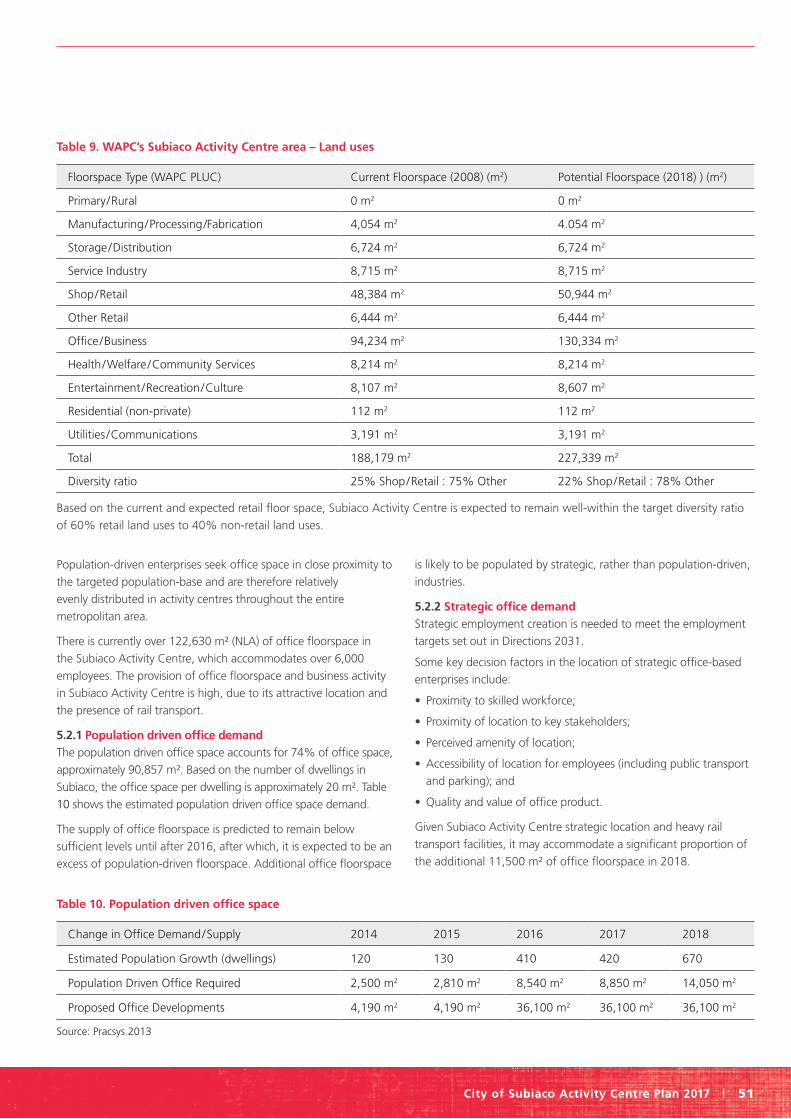
City of Subiaco Activity Centre Plan 2017 | 51
Population-driven enterprises seek office space in close proximity to
the targeted population-base and are therefore relatively
evenly distributed in activity centres throughout the entire
metropolitan area.
There is currently over 122,630 m² (NLA) of office floorspace in
the Subiaco Activity Centre, which accommodates over 6,000
employees. The provision of office floorspace and business activity
in Subiaco Activity Centre is high, due to its attractive location and
the presence of rail transport.
5.2.1 Population driven office demand
The population driven office space accounts for 74% of office space,
approximately 90,857 m². Based on the number of dwellings in
Subiaco, the office space per dwelling is approximately 20 m². Table
10 shows the estimated population driven office space demand.
The supply of office floorspace is predicted to remain below
sufficient levels until after 2016, after which, it is expected to be an
excess of population-driven floorspace. Additional office floorspace
is likely to be populated by strategic, rather than population-driven,
industries.
5.2.2 Strategic office demand
Strategic employment creation is needed to meet the employment
targets set out in Directions 2031.
Some key decision factors in the location of strategic office-based
enterprises include:
• Proximity to skilled workforce;
• Proximity of location to key stakeholders;
• Perceived amenity of location;
• Accessibility of location for employees (including public transport
and parking); and
• Quality and value of office product.
Given Subiaco Activity Centre strategic location and heavy rail
transport facilities, it may accommodate a significant proportion of
the additional 11,500 m² of office floorspace in 2018.
Table 9. WAPC’sSubiacoActivityCentrearea–Landuses
Floorspace Type (WAPC PLUC) Current Floorspace (2008) (m2) Potential Floorspace (2018) ) (m2)
Primary/Rural 0 m2 0 m2
Manufacturing/Processing/Fabrication 4,054 m2 4.054 m2
Storage/Distribution 6,724 m2 6,724 m2
Service Industry 8,715 m2 8,715 m2
Shop/Retail 48,384 m2 50,944 m2
Other Retail 6,444 m2 6,444 m2
Office/Business 94,234 m2 130,334 m2
Health/Welfare/Community Services 8,214 m2 8,214 m2
Entertainment/Recreation/Culture 8,107 m2 8,607 m2
Residential (non-private) 112 m2 112 m2
Utilities /Communications 3,191 m2 3,191 m2
Total 188,179 m2 227,339 m2
Diversity ratio 25% Shop/Retail : 75% Other 22% Shop/Retail : 78% Other
Based on the current and expected retail floor space, Subiaco Activity Centre is expected to remain well-within the target diversity ratio
of 60% retail land uses to 40% non-retail land uses.
Table 10. Population driven office space
Change in Office Demand/Supply 2014 2015 2016 2017 2018
Estimated Population Growth (dwellings) 120 130 410 420 670
Population Driven Office Required 2,500 m2 2,810 m2 8,540 m2 8,850 m2 14,050 m2
Proposed Office Developments 4,190 m2 4,190 m2 36,100 m2 36,100 m2 36,100 m2
Source: Pracsys 2013
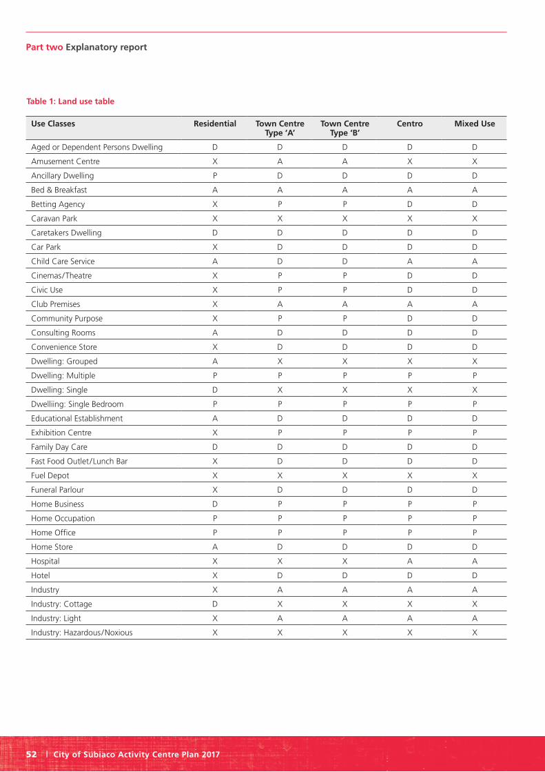
Part two Explanatory report
52 | City of Subiaco Activity Centre Plan 2017
Table 1: Land use table
Use Classes Residential Town Centre Type ‘A’
Town Centre Type ‘B’
Centro Mixed Use
Aged or Dependent Persons Dwelling D D D D D
Amusement Centre X A A X X
Ancillary Dwelling P D D D D
Bed & Breakfast A A A A A
Betting Agency X P P D D
Caravan Park X X X X X
Caretakers Dwelling D D D D D
Car Park X D D D D
Child Care Service A D D A A
Cinemas/Theatre X P P D D
Civic Use X P P D D
Club Premises X A A A A
Community Purpose X P P D D
Consulting Rooms A D D D D
Convenience Store X D D D D
Dwelling: Grouped A X X X X
Dwelling: Multiple P P P P P
Dwelling: Single D X X X X
Dwelliing: Single Bedroom P P P P P
Educational Establishment A D D D D
Exhibition Centre X P P P P
Family Day Care D D D D D
Fast Food Outlet /Lunch Bar X D D D D
Fuel Depot X X X X X
Funeral Parlour X D D D D
Home Business D P P P P
Home Occupation P P P P P
Home Office P P P P P
Home Store A D D D D
Hospital X X X A A
Hotel X D D D D
Industry X A A A A
Industry: Cottage D X X X X
Industry: Light X A A A A
Industry: Hazardous/Noxious X X X X X

City of Subiaco Activity Centre Plan 2017 | 53
Use Classes Residential Town Centre Type ‘A’
Town Centre Type ‘B’
Centro Mixed Use
Industry: General X X X X X
Industry: Service X D D D D
Laundromat X D D D D
Licensed Premises – Other X D D D D
Liquor Store X D D A A
Market X D D D D
Medical Centre X D D P P
Motel X D D A A
Motor Vehicle, Boat or Caravan Sales X X X A A
Motor Vehicle Repair X X X X X
Motor Vehciel Wash X X X A A
Night Club X A A X X
Office X D D P P
Park Home Park X X X X X
Place of Public Worship A A A A A
Reception Centre X D D A A
Recreation – Privae D D D D D
Research & Development X D D D D
Restaurant A P P D D
Restricted Premises X X X X X
Retirement Village D A A D D
Service Station X A A A A
Serviced Apartment A D D D D
Shop X P P D D
Short Stay Dwelling A D D D D
Showroom X D D D D
Small Bar X D D A A
Special (licensed) Facility X D D D D
Storage X X X X X
Tavern X A A A A
Telecommunications Infrastructure D D D D D
Trade Display X X X X X
Veterinary Centre X D D D D
Winery X X X X X

Part two Explanatory report
54 | City of Subiaco Activity Centre Plan 2017
5.2.3 Community, civic and cultural facilities
Subiaco has a substantial and well established civic node at the
southern edge of the activity centre.
The following is an extract from the City’s Local Planning Strategy
relating to Infrastructure and Services:
Accommodating an increase in population and achieving the State
Government requirements relating to urban growth management
will require upgrades to existing infrastructure and services.
The city acknowledges the need for the State Government to
undertake these upgrades in a timely manner. The absence of
proper State Government strategic Activity Centre Planning and
provision will be detrimental in the longer term to the city and
inner metropolitan local governments as a whole.
5.3 Employment
5.3.1 Employment capacity
The Subiaco Activity Centre will have an estimated additional
70,000 m² commercial floorspace by 2026 (excluding additional
retail floorspace). Table 11 shows the net employment position
expected, suggesting a net loss or minimal net gain of
employment over the period to 2026. These figures do not reflect
indirect employment losses resulting from flow-on effects to
industries up or down the supply chain within the activity centre.
The net loss of jobs may therefore be greater.
These projections assume the timely development or redevelopment
of land to accommodate new commercial floorspace. Delays in the
above can result in higher employment losses.
5.3.2 Employment self-sufficiency
Employment self-sufficiency (ESS) – is the proportion of jobs
located in a geographic area (region, corridor, local government)
relative to the residents in that same area who are employed
in the workforce. For example, if the area has 1,000 employed
residents and 450 local jobs available, the employment self-
sufficiency rate is 45%.
There is a Directions 2031 ESS target of 121% by 2031 for the
central sub-region.
• ESS of the central sub-region dropped from 124% to 122%
between 2006 and 2011.
• Employment growth is expected across the central sub-region.
• Subiaco’s ESS is currently 256%, meaning there are over 2.5
jobs in the City for every employable resident.
• Additional dwellings needed for evening out the ESS to more
balanced levels.
• 3,128 jobs are needed in Subiaco by 2026 to support the
Directions 2031 ESS target.
• Approximately 72% of the additional employment will need to
be strategic in nature.
• Some 2,178 City of Subiaco residents are employed in Subiaco
The Subiaco Activity Centre is unlikely to contribute to the ESS
target for the Central Sub-Region, due to the already high
ESS and also projection of increased residential population.
Employment would have to grow faster than residential
population for the ESS to grow, making any significant
contribution to the sub-regional ESS difficult for a centre already
high in employment.
5.3.3 Employment implications
The other high-level activity centres in the surrounding area may
be required to accommodate the additional employment needed
to meet the Central Sub-Region ESS target. The employment
directly related to Subiaco Oval and PMH will be relocated in the
Central Sub-Region. However, the loss of direct employment is
expected to have significant implications for the overall economic
performance of the activity centre.
5.4 Retail needs assessment Future retail floorspace demand for the Subiaco Activity Centre
over the next five years has been estimated. Retail floorspace has
been classified in three categories:
• Convenience Retail - typically comprised of day-to-day needs
such as groceries;
• Comparison Retail - typically comprised of durable and
household goods; and
• Entertainment - includes bars, restaurants and cafes.
Table 11: Net change in local labour force by 2026
Employment Change in Jobs
Current Employment (2011) 20,160
Loss from PMH (2015) – 2,400
Loss from Subiaco Oval (2018) – 300
Loss from KEMH (2026) – 1,600
New Commercial Floorspace + 3,500 to + 4,700
Net Change – 800 to + 400
Source: Pracsys 2013

City of Subiaco Activity Centre Plan 2017 | 55
5.4.1 Future demand
Future demand for retail goods and services has been estimated
from the resident population within the main trade area, and
the estimated visitors and workers. Assumptions for future
demand are:
• Population in Subiaco Activity Centre
- Current population (2013): 1,170
- Future population (2018): 2,490
• Population in Remaining Main Trade Area
- Current population (2013): 103,600
- Future population (2018): 113,450
5.4.2 Future supply
Future supply of retail floorspace has been estimated from the
known developments approved for construction in the Subiaco
Activity Centre over the next five years. Table 12 shows the
current and projected future supply of retail and entertainment
floorspace in the Subiaco Activity Centre.
5.4.3 Retail market potential
5.4.3.1 Convenience retail performance
• Currently trading above benchmark levels
• Demand from residential and worker growth is expected to
be sufficient for above average productivity
• Enough demand to support additional floorspace of
approximately 3,750 m²
• Additional floorspace may be over-stated
• Additional potential floorspace to support future demand
would be approximately 2,000 m² to 3,000 m².
5.4.3.2 Comparison retail performance• Currently trading below ideal productivity levels
• Average comparison retail productivity for the region is
predicted to increase over the next five years.
• Increase in demand pool necessary to reach productivity target
• Comparison floorspace can reach productivity levels by 2018 if
demand pool is increased
• Current trading conditions suggest a supply contraction in the
short term.
5.4.4 Entertainment floorspace market potential• Potential additional expenditure pool of $5.4m, approximately
1,210 m² of floorspace.
• Reduce entertainment expenditure demand by over $10million
due to stadium loss
• Additional residents over the next five years will increase
entertainment floorspace productivity to support existing and
expected supply.
• Perth City Link, Elizabeth Quay and Waterbank will potentially
compete with the entertainment destination at Subiaco
5.4.5 Retail needs assessment implications
• Potential for short term contraction retail market potential for
the Subiaco Activity Centre
• Factors affecting retail floorspace demand beyond 2018:
- Local demand for convenience retail and entertainment to
increase with resident population growth.
- Increase in comparison retail demand likely to depend on
competitor’s offerings.
- Future demand for retail, especially convenience retail and
entertainment will potentially be reduced due to the loss of
employment from Subiaco Oval, Princess Margaret Hospital
and eventually King Edward Memorial Hospital.
- The redevelopment of Subiaco Oval, Princess Margaret
Hospital and King Edward Memorial Hospital sites has the
potential to increase both demand and supply for all types of
retail floorspace.
- Office floorspace and other commercial land uses
development has the potential to increase retail
floorspace demand.
Table 12: Baseline scenario supply assumptions
Floorspace Type Subiaco Acivity Centre
Current Floorspace (2013) Future Floorspace (2018)
Convenience Retail 6,800 m2 8,720 m2
Comparison Reail 24,660 m2 24,920 m2
Entertainment Retail 17,200 m2 16,820 m2
Office 122,630 m2 153,540 m2
Source: Pracsys 2013: MRA 2013; WAPC 2013; http://www.northone.com.au/ 2013; http://www.subiaco.com.au/ 2013.

Part two Explanatory report
56 | City of Subiaco Activity Centre Plan 2017
5.5.2 Dwellings
The State Government requires an additional 3,600 dwellings
across the Subiaco Local Government Area by 2031. This is
intended to be achieved by denser urban infill on potential
redevelopment sites and targeted increases in appropriate areas.
The activity centre plan takes a targeted approach to achieving
desirable residential densities established by State Planning Policy
4.2 Activity Centres for Perth and Peel. Subiaco is a Secondary
Centre under this policy, which is required to achieve a minimum
density per gross hectare of 25 dwellings and a desirable density
of 35 dwellings.
In arriving at the development standards contained within this
activity centre plan, an urban design study was undertaken that
tested a range of building heights, street interface conditions and
development intensities. Three options were initially prepared and
tested with the community. Each provided height and associated
development standard increases to enable development of
additional housing throughout the centre, either in mixed use
developments or as more intense residential developments within
existing residential areas. Each option achieved the minimum
densities required by SPP 4.2 Activity Centre for Perth and Peel.
Urban Design Framework Approach
The approach to the urban design frameworks for the Subiaco
Activity Centre related primarily to reinforcing its existing place
structure. In this regard, Rokeby Road, Hay Street and Bagot Road
form the key movement and activity spines within the activity
centre across each of the urban design framework scenarios.
Overlaid onto that structure is a public space framework, whereby
focus points for activity, or hotspots, can be created within
the public realm, around which activity and built form can be
intensified.
The shopping experience within Subiaco exists currently within
the core area, or town centre zone. Given projected demand for
comparison and convenience retail, it is not necessary to expand
the extent to which retail activities occur. Rather, they should
be consolidated within the existing core area, and if possible,
intensified around the public space hot spots.
Outside of the existing town centre zone, a mix of commercial
and residential land uses currently occurs and can continue to
occur within each of the urban design frameworks. A range of
other facilities, such as community services, will be intensified
around the current civic node and in a programmed event sense
within the other public spaces throughout Subiaco.
The approach to each of the urban design frameworks will be
considered in relation to:
- urban form;
- activity; and
- movement.
with an overall consideration towards a more sustainable Subiaco.
Heritage Considerations
A heritage protection area has been designated for the town
centre core along Rokeby Road and Hay Street for each of the
urban design frameworks. In this regard, built form would need
to contemplate the scale of heritage properties either on site
or adjacent to them and provide the appropriate streetscape
interface, generally somewhere between two and four storeys.
This is not to say that new development is not to be contemplated
within the heritage area, but that an appropriate character
response, with an emphasis on detail of design rather than style,
is required. Contemporary built form is appropriate within Subiaco
in so far as it contemplates and complements the established
character of Subiaco.
The Urban Design Framework Options
The focus for activity in each of the framework options is Rokeby
Road and Hay Street, anchored by activator points at the Subiaco
train station and a southern activation point, at the civic node.
Retail and hospitality activity will continue to activate these
Table 13: Directions 2031 (WAPC) Targets and Subiaco dwelling range comparison
1 Bedroom 2 Bedrooms 3 Bedrooms 4+ Bedrooms
Directions 2031 (WAPC) Targets 10 to 20% 30 to 40% 30 to 40% 10 to 25%
2011 Dwelling Range – 9,133 Private Dwellings (Source: ABS, 2011)
16,4% 32.2% 34.6% 15.2%
The current dwelling diversity across Subiaco is consistent with Directions 2031 targets. Infill development will increase the proportion
of 1 and 2 bedroom dwellings.
5.5 Residential population targets
5.5.1 Diversity
The WAPC housing targets for Subiaco is as follows:

City of Subiaco Activity Centre Plan 2017 | 57
key spines and reinforce the intended public space network
throughout Subiaco.
Landmark sites correspond to opportunity sites which have
been identified to take increased development potential so that
State Policy employment and residential targets can be met.
The landmark sites are located near to the train station on the
Pavilion Market site (the northern threshold for the town centre
core). Two landmark sites are located on Hay Street, one at the
existing Colonnade Shopping Centre, the other at the Subiaco
Village. These sites would act as entry or threshold points into
and out of the town centre. The final landmark sites are located
at Crossways Shopping Centre and Coles and will reinforce the
activity generated by the civic node. Each of these sites could
accommodate additional height and development, befitting their
status as landmark sites.
Beyond the Rokeby Road / Hay Street spine, taller development
may occur with a street interface up to four storeys. This is widely
considered to be a comfortable pedestrian scale, while enabling
sufficient intensity of development and activity. It is also consistent
with the established scale throughout the Subiaco Redevelopment
Area. In some areas, buildings up to twelve storeys can be
considered where public benefit is provided to the community. In
this regard, additional development intensity is achieved, enabling
State Policy targets to be met. Community benefit is attained,
where features such as additional pedestrian linkages, open space,
urban plazas and environmentally conscious built form is created
for the benefit of the character and the function of Subiaco as a
secondary centre.
The urban design framework options differed in development
height and intensity based on likely future rapid transit routes
through or around the centre. Framework 1 offered the lowest
scale, being premised 2 to 4 storey height outside of nominated
character zones, and up to 12 storeys at landmark sites, subject
to provision of public benefit. Frameworks 2 and 3 offered taller
development, particularly to the west of Rokeby Road and north
of Barker Road, where commercial and medium density housing
currently exist. Street edges ranged between 4 and 5 storeys, with
taller built form set back from the street edges.

Part two Explanatory report
58 | City of Subiaco Activity Centre Plan 2017
Outcome
The outcome of the urban design study was to increase residential
densities and development standards within the town centre
core and mixed use areas, as well as up-coding some existing
medium to high density residential precincts. Some parts of the
activity centre were retained as per current standards, where
the community desired existing neighbourhood character to be
retained.
The preferred urban design framework for Subiaco enables at
least 1,359 dwellings being accommodated over and above the
existing 1,372 dwellings. This equates to an anticipated total of
2,731 dwellings, and over the 72 hectares of the activity centre
area (excluding 11 hectares of MRS reserve), a gross residential
density of 37 dwellings per hectare can be achieved. Additional
dwellings will also be accommodated outside the activity centre
area within the North Subiaco Structure Plan area, such as
along Subiaco Road and at the Princess Margaret Hospital site.
Furthermore, the city is undertaking a review of its Town Planning
Scheme, which will deliver substantially increased dwelling
numbers in key areas around the City of Subiaco.
The additional dwellings will be achieved over time through
redevelopment. The activity centre plan promotes residential
development within areas outside of the town centre core and
within nearby mixed use areas. To achieve height bonuses in
landmark sites, residential dwellings are required to be provided
consistent with the statutory provisions that improve the public
realm. Considered on a holistic basis, this will achieve State Policy
targets.
To demonstrate this, the table below represents an assessment of
the minimum dwelling yields within the Activity Centre Plan and
North Subiaco Structure Plan areas for identified opportunity sites:
Additional housing densities within the Subiaco Activity Centre
(as described in the table above) can be achieved by increasing
development standards (namely plot ratio and building height)
and the associated R-Code. The additional heights and plot ratios
are described in detail in Part One of the Activity Centre Plan. The
above opportunity sites will be permitted to develop to a plot
ratio of between 2:1 and 3:1 or in accordance with the relevant
planning framework applied. This, in combination with the
inherent flexibility of the Residential Design Codes and the draft
Design WA State Planning Policy, will enable at least this number
of dwellings to be achieved.
Table 14. Land Use
Site Estimated Number of Dwellings
Timing
2011-2016 2016-2021 2021-2016 2026-2031 Beyond
Princess Margaret Hospital 400 200 200
King Edward Memorial Hospital* 300 300
Bunnings Homebase 380 100 280
Pavilion Markets 292 292
1 Seddon Street 31 31
Colonnade Shopping Centre 94 94
Coles 54 54
Crossways 69 69
Subiaco Village 160 100 60
Australian Fine China 328 100 228
Hay Street East of Town Centre* 250 100 100 50
Self-Lock Storage Site 110 (or more if increased in density)
110
Other* 500 50 150 150 150
TOTAL 2,968 150 1,024 1,014 500 280
*Dwelling numbers are subject to rezoning proposals to the Town Planning Scheme.

City of Subiaco Activity Centre Plan 2017 | 59
The SACP Contribution to Local Government Targets
The City’s revised targeted growth strategy means that
approximately 61% of the required additional population and
dwellings will be accommodated using the adopted Subiaco
Activity Centre Plan and North Subiaco Structure Plan, which
include the KEMP and PMH sites. Accordingly, the remaining 39%
or 2,400 dwellings are required to be accommodated in station
precincts, transport corridors, the Jolimont Activity Centre and
other mixed use/local centres. The City’s dwelling yield projections
for these precincts clearly demonstrate that the remaining
required dwellings are able to be achieved by 2050.
The increase in number of dwellings within the activity centre,
and more broadly throughout the City of Subiaco, will occur
incrementally as redevelopment of sites occur. Redevelopment will
be supported by clear development standards, proscribing density,
height, setback and land use mix requirements. Development
standards vary across the activity centre plan area depending on
intended local character and amenity outcomes.
To achieve the State population targets the following is required:
1. Density Codes: Increased residential yields (and therefore
built form requirements) are required across the Activity Centre
Plan area. Residential Densities will be established by an R AC-0
designation on the Scheme Map for the Activity Centre Plan area.
2. Planning Framework: The following is recommended:
- Adopt an Activity Centre Plan to guide development supported
by Town Planning Scheme provisions based on Part 1 of this
report.
- Plot ratios will apply to the Activity Centre Plan area
- Residential plot ratios will be permitted beyond a non-
residential plot ratio cap to encourage the development of
residential dwellings throughout the Activity Centre.
- Building heights will apply to the Activity Centre Plan area in
both storeys and metres
- A local planning policy be prepared that establishes other built
form development standards across the Activity Centre Plan
area.
3. Housing Diversity: There is no need to require through policy a
particular mix of housing, as Subiaco already exhibits a good mix
of housing types.
4. Affordable Housing: The Activity Centre Plan is not the
appropriate mechanism to require affordable housing within
Subiaco. Rather, a broader policy should be established for the
wider local government area, which may have particular policy
settings for the activity centre area.
6.0 Urban form
6.1 Urban structure and built form
6.1.1 Subiaco’s urban design framework
The approach to Subiaco’s urban design framework relates
primarily to reinforcing its existing structure; and to place. In this
regard, Rokeby Road, Hay Street and Bagot Road form the key
movement and activity spines within the activity centre.
Overlaid onto that structure is a public space framework,
whereby focus points for activity, or hotspots, can be created
within the public realm, around which activity and built form
can be intensified.
The shopping experience within Subiaco exists currently within
the core area, or town centre zone. Given projected demand for
comparison and convenience retail, it is not considered necessary
to expand the extent to which retail activities occur. Rather,
they should be consolidated within the existing core area, and if
possible, intensified around the public space hot spots.
Outside of the existing town centre zone, a mix of commercial
and residential land uses currently occurs and can continue to
occur. A range of other facilities, such as community services,
will be intensified around the current civic node and through
programmed events within the other public spaces
throughout Subiaco.
6.1.1.1 Activity focus
The focus for activity is undoubtedly Rokeby Road and Hay
Street, anchored by activator points at the Subiaco train station
and a southern activation point, of a different type, at the civic
node. Retail and hospitality activity will continue to activate these
key spines and reinforce the intended public space network
throughout Subiaco.
The town centre core will retain its current extent, with the
surrounding areas accommodating other mixed uses, such as
residential and commercial development. However the need to
activate the streets with retail frontages in these areas is
not necessary.
6.1.1.2 Landmark and opportunity sites
Interlinked with the public space network are a number of
landmark sites that act as threshold points into and out of the
centre. These are also consistent with Subiaco’s existing structure,
and would reinforce in a built form sense, the hot spot activity
areas intended throughout the town centre.
The landmark sites also correspond to opportunity sites which
have been identified to take increased development potential
so that State Policy employment and residential targets can be
met. The landmark sites are located near to the train station
on the former Pavilion Market site (the northern threshold for

Part two Explanatory report
60 | City of Subiaco Activity Centre Plan 2017
the town centre core). Three landmark sites are located on Hay
Street, one at the existing Colonnade Shopping Centre, one at
the Ace Cinemas site and the other at the Subiaco Village. These
sites would act as entry or threshold points into and out of the
town centre. King Edward Memorial Hospital and Homebase
provide this function to the north and south of the centre. The
final landmark site is located at Crossways Shopping Centre and
would counterpoint the activity generated by the civic node.
Each of these sites could accommodate additional height and
development, befitting their status as landmark sites.
Providing these sorts of facilities within the town centre
also helps to reinforce Subiaco’s character and to enable
wayfinding markers.
6.1.1.3 A pedestrian scaled street interface
Beyond the Rokeby Road / Hay Street spine, taller development
may occur with a street interface up to four storeys. This is
widely considered to be a comfortable pedestrian scale, whilst
also enabling an intensity of development and activity. It is also
consistent with the established scale throughout the Subiaco
redevelopment area. In some areas, buildings up to eight storeys
can be considered where public benefit is provided to the
community. In this regard, additional development intensity is
achieved, enabling State Policy targets to be met. Community
benefit is attained, where features such as additional pedestrian
linkages, open space, urban plazas and environmentally conscious
built form is created for the benefit of the character and the
function of Subiaco as a secondary centre.
6.1.1.4 Urban form and movement
Finally in terms of vehicle movements, Subiaco’s permeable grid of
streets means that accessibility to and through the centre will be
enabled. Regional traffic will tend to be directed around the Subiaco
activity centre rather than through it, to roads such as Railway
Parade, Salvado Road, Roberts Road and Hay Street. There is the
ability for the Activity Centre Plan to enable Hay Street and Roberts
Road transitioning to two way streets in the future, with Roberts
Road accommodating a greater level of private vehicle traffic than
Hay Street, which will accommodate more pedestrians, cyclists
and public transport. This work will require two way traffic to be
accommodated within the City of Perth and it would make sense for
that functionality to continue through Subiaco at that time.
6.1.1.5 Implications for urban form due to high frequency transit The preferred route through Subiaco is to allow a high frequency
transit connection through the centre, past the existing train
station and along Rokeby Road, connecting then onto Thomas
Street. This scenario would enable stops and interchange facilities
at the Subiaco train station, one stop within the town centre
on Rokeby Road and another stop adjacent to the civic node.
Other stops would be contemplated south of the activity centre
at appropriate locations. These stop locations would benefit
activity within the centre by allowing ease of access for people
into Subiaco and to its retail and entertainment businesses. The
running of a high frequency transit route through Subiaco on
Rokeby Road would require shared running of services, and in
that regard, a reorganisation of Rokeby Road to accommodate the
services and associated facilities required.
6.1.2 Place and urban form considerations
The following principles should be applied to the development of
both the public and private realm throughout Subiaco.
• Character: Good public realm should contain places with their
own image and identity. Performance indicators include: places
of cultural heritage; key built and natural landmarks; cleanliness
and quality of maintenance; and obvious physical barriers
or boundaries.
• Universal access and permeability: Public realm design should
provide a place that is easy to get to, move through, and
that connects with its surroundings. Performance indicators
include: visibility from a distance, walkability; proximity to public
transport; standard of equitable access; and the number of
linkages or paths connected to the space.
• Legibility and wayfinding: Public places should be easy to
understand and orientate. Performance indicators include: the
visibility of surrounding landmarks; the clarity of information
signage; the extent of signage clutter and visual pollution; and
the amount of casual surveillance of pathways and spaces.
• Safety: Public places should feel and be safe. Performance
indicators include: casual surveillance of spaces by adjacent
inhabitants; human activity in the spaces; lighting standards;
code compliant ground gradients and changes in level;
minimisation of areas of potential concealment; appropriate
maintenance of planting to ensure sight lines along paths and
between spaces; consideration of the human health impacts
of materials.
• Use and adaptability: Good public realm should provide places
that can change and adapt as required, spaces that match the
pattern of behaviour that people engage in (the activity that
people want to engage in), and places that can change easily or
accommodate different uses over time. Performance indicators
include: the number of activities that could reasonably take
place in the space without rearrangements and refurbishing; the
range of social activity and interaction; and seasonal weather or
microclimate conditions which would interrupt the intended or
spontaneous use of the space.
• Human scale: People are the users of public spaces, and the
spaces must function at human scale. Performance indicators
include: the extent to which space is enclosed and defined
physically and perceptually; and the ratio of building height to
street/public space width.

City of Subiaco Activity Centre Plan 2017 | 61
• Comfort: The design of the public realm should respond to, and
provide, suitable micro-climates (temperature, shade, breezes) and
public furniture that is ergonomically comfortable. Performance
indicators include: the provision of shelter; places of shade and
sun; range of comfortable seating options; access to public toilets;
access to drinking water; provision of street furniture (bike racks,
bins, street lamps, bollards, seating); and consideration of wind
tunnelling effects on human safety and comfort.
• The ‘active edge’ effect: Public realm design must consider the
interrelationships between public spaces and private uses within
buildings. Edges of public spaces should add to activity and
spontaneous exchanges between people. Performance indicators
include: the number of premises every 100 metres; numbers
of doors and windows every 100 metres; casual surveillance of
pathways and spaces; the range of functions along the edge;
depth and relief in the building surface; high quality materials
and refined details.
• Cultural vitality and sociability: Good public realm design
should provide exciting, safe, attractive places, as well as
spaces that offer artistic expression and fulfilment. Performance
indicators include: the mix of surrounding uses; the frequency
of community events/activities; economic vitality; the number of
visitors to the space; sense of pride and community ownership;
art work collaborations; the presence of children and seniors.
• Variety: Public realm design should offer variety and diverse
choices when meeting human needs. Performance indicators
include: the number of points of converging activity or meeting
spots in the space; the mix of surrounding uses; areas of open,
uncluttered space that can be used for different uses; and hours
of use or activity on a daily, weekly and seasonal basis.
• Green spaces and landscapes: Good public realm design
should take advantage of the benefits of ‘urban green space’.
Performance indicators include: the number of trees per lineal
metre/area in the space; area of permeable ground surfaces
and soft landscaping for water infiltration; rate of carbon
sequestration and air pollutant filtration by trees; and fit with
broader landscape strategy or vision for the whole city or area.
• Sustainability: Good public realm design should ensure inter-
generational ecological, social and economic needs are met
without compromising the future. Performance indicators
include: low embodied energy levels of materials and
construction methods; low human health impacts of materials
or plants (e.g. some flowers exacerbate asthma attacks and
materials allergic reactions); carbon offsets provided by planting;
integrated water cycle management including water sensitive
urban design; high degree of local supply of talent, resources and
renewable materials, minimal waste generation and disposal;
conservation and re-lifing of existing heritage, buildings, good
spaces; renewable energy generation opportunities; and a high
degree to which the proposal holistically satisfies the other
performance criteria.
6.1.3 Noise attenuation in a mixed-use context Development within mixed use precincts, whilst appropriate
for a town centre like Subiaco, must take into account noise
impact measures to ensure ongoing liveability and comfort for
residents, and to protect the viability of local businesses. The
overall objective at Subiaco will be to safeguard occupants from
loss of amenity or health issues caused by excess sound being
transmitted between adjoining buildings or dwelling units.
6.1.4 Character and heritage
A place’s character and charm are influenced by the stories of its
past, by its development history and the way this is reflected in its
built form. Retention, restoration, adaptation and sympathetic
development of places of historic significance within a centre
help to entrench a sense of place and a richness of character.
This is not to say development should be constrained, but rather,
development should enhance and respond to those characteristics
that establish Subiaco’s sense of place.
Griffiths Architects were commissioned by the City of Subiaco to
undertake a heritage assessment of a defined area along Rokeby
Road and Hay Street (existing town centre core) in support
of the Activity Centre Plan. The assessment of significance
suggested that the Rokeby Road and Hay Street Heritage area
warranted identification as a Heritage Area under the Town
Planning Scheme. All buildings within the defined area were
graded according to the level of contribution they made to the
significance of the area as a whole:
• Considerable contribution
• Some / moderate contribution
• No contribution
Whilst not all buildings make a contribution to the heritage
significance of the area, a number of them contribute to the
character of Subiaco’s town centre through appropriate materials,
detailing and scale. The significance of the area is outlined in the
statement of significance:
Rokeby Road and Hay Street Heritage Area, streetscapes
comprising predominantly early twentieth century and inter-
war period brick, render and iron construction commercial and
institutional buildings, has cultural heritage significance for the
following reasons: -
• They are aesthetically pleasing streetscapes with a strong heritage
character, with intact and many reasonably intact Federation
and early Inter-War commercial and institutional buildings with
Subiaco Hotel, Regal Theatre and the Rogerson Buildings being
outstanding aesthetic examples of their time and type;
• it is a fine substantial and representative example of a town
centre based on the suburban railway, with many fine buildings
developed through the gold boom period, illustrating the scale
and standard of commercial buildings considered appropriate
for merchants in the early twentieth century;

Part two Explanatory report
62 | City of Subiaco Activity Centre Plan 2017
• it is the heart of the City and contributes to the community’s
sense of place, while places such as the Subiaco Hotel, Regal
Theatre, Doyle Court, and the Rogerson Buildings have
particular significance in terms of the identity of the place, in
part arising from their landmark qualities; and,
• the street grid, cadastre and many of the built elements
of Rokeby Road and Hay Street Heritage Area make up a
significant townscape, representative of the early twentieth
century and to a lesser extent the inter-war period.
Most of the development that was constructed after World
War II is of little significance or on occasion is intrusive. Some
later additions to early buildings are of little significance, as are
modifications to original facades.
Importantly for the Activity Centre Plan, prior to 2013, Griffiths
Architects recommended that the Rokeby Road and Hay Street
Heritage Area warranted identification as a Heritage Area under
the Town Planning Scheme. In October 2013, Council declared
the area a Heritage Area. In addition, Griffiths suggested the
TPS should identify the characteristics that make up the precinct,
as well as the streetscape characteristics from the very late
nineteenth and early twentieth century, up to the inter-war
period that make a considerable, some, or moderate contribution
to the setting.
In 2015 new planning regulations were gazetted, Schedule 2,
clause 4 (3)(a) of the Planning and Development (Local Planning
Scheme) Regulations 2015 requires that a planning policy be
adopted for every heritage area. Planning Policy 3.8 ‘Development
guidelines for the Rokeby Road and Hay Street Heritage Area’
applies to the heritage area and provides development guidelines
based on the principles of the Australia ICOMOS Burra Charter.
The guidelines aim to conserve, reveal and enhance the
streetscape and ensure that new development is compatible
in terms of height, bulk and scale, and is in harmony with and
maintains the integrity of the area’s cultural heritage significance
and traditional streetscape character.
6.1.5 Activity centre codes
A number of activity centre area codes have been identified
within the Subiaco Town Centre. As Subiaco is a mature centre
surrounded by residential development, which is predominately
low density and / or has heritage characteristics there was a need
to adopt a fine grain approach to development opportunities.
The different areas and in particular the transition areas have been
identified to balance development opportunities with the existing
character of Subiaco. The number of and characteristics of the
areas is in response to the quality of the existing character and the
desire to ameliorate any impacts on surrounding land users.
6.1.5.1 Town Centre Type ‘A’ The Town Centre ‘A’ Code is Subiaco’s principal location for
commercial, civic, entertainment and retail activity. It will gain
in popularity as a residential location for those seeking an urban
lifestyle. Diversity and vitality are fundamental to the overall land
use profile, facilitated by providing the widest range of facilities
and services which enables Subiaco’s centre to fulfil its many
functions while sustaining interest and activity on a virtually
continuous basis. The scale and intensity of activities help to
distinguish it from surrounding areas, both in terms of maximising
the potential of Subiaco for transit oriented development, and to
respect the acknowledged heritage qualities of Rokeby Road and
Hay Street.
6.1.5.2 Town Centre Type ‘B’ The Town Centre ‘B’ Code complements and mirrors the function
of the Town Centre ‘A’ zone, however its development scale is
slightly lower reflective of local topography and distance from
Subiaco train station. Town Centre ‘B’ will be a principal location
for commercial, civic, entertainment and retail activity. It will gain
in popularity as a residential location for those seeking an urban
lifestyle. Diversity and vitality are fundamental to the overall land
use profile, facilitated by providing the widest range of facilities
and services which enables Subiaco’s centre to fulfil its many
functions while sustaining interest and activity on a virtually
continuous basis. The scale and intensity of activities help to
distinguish it from surrounding areas, both in terms of maximising
the potential of Subiaco for transit oriented development, and to
respect the acknowledged heritage qualities of Rokeby Road and
Hay Street.
6.1.5.3 Centro
The Centro Code is intended to develop as mixed use areas
comprising primarily permanent residential accommodation
and office / business activities, together with a range of
complementary uses. Ground floor development shall generally
be non-residential with upper floors containing a mix of residential
and non-residential uses in a complementary manner.
6.1.5.4 Mixed use
The Mixed Use Code is intended to develop as lively and diverse
mixed use areas providing for an extensive range of residential
and commercial uses to be established either in association with
each other or independently in a compatible manner. Mixed
residential / commercial development is strongly encouraged,
provided that conflict between the residential and non-residential
components is minimised. Development fronting Rokeby and
Bagot Roads shall contain a non-residential ground floor use.
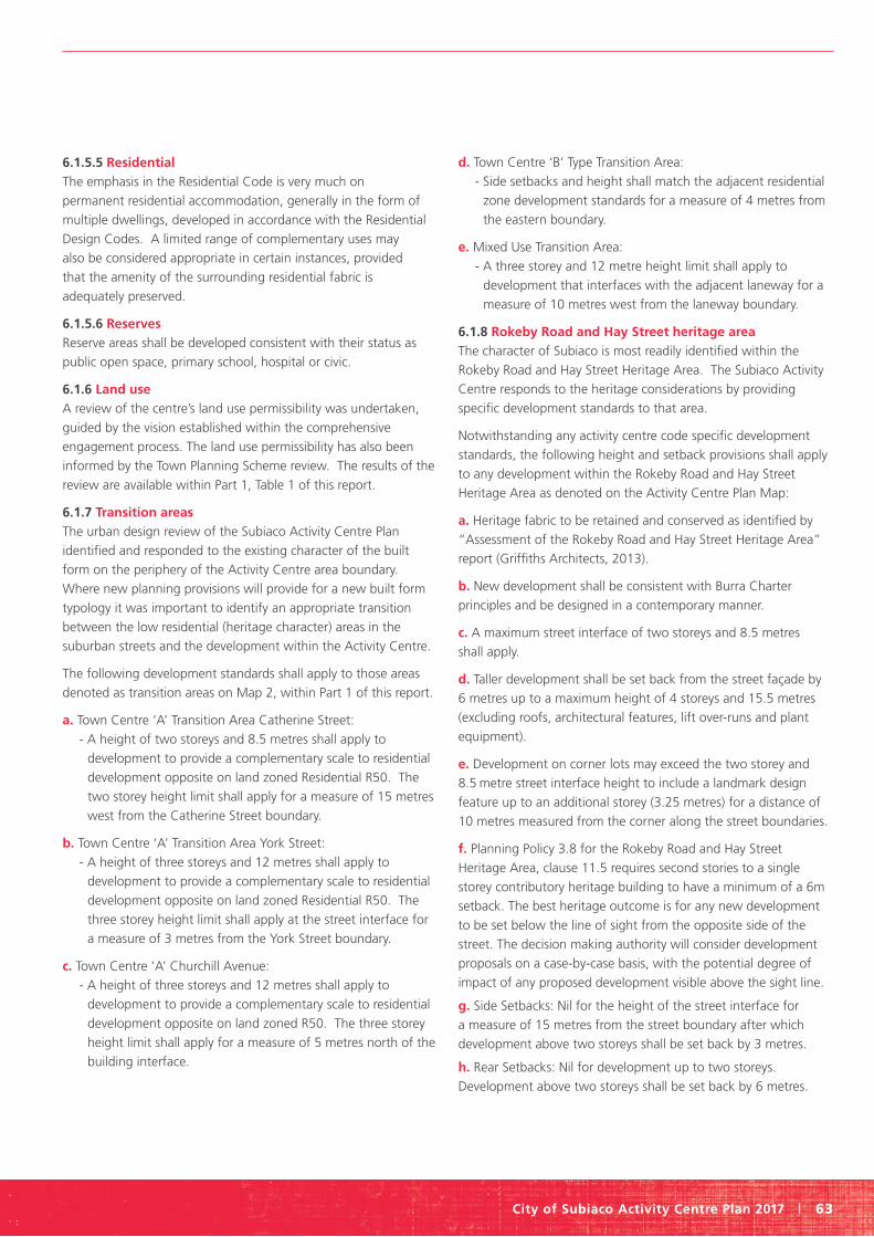
City of Subiaco Activity Centre Plan 2017 | 63
6.1.5.5 Residential The emphasis in the Residential Code is very much on
permanent residential accommodation, generally in the form of
multiple dwellings, developed in accordance with the Residential
Design Codes. A limited range of complementary uses may
also be considered appropriate in certain instances, provided
that the amenity of the surrounding residential fabric is
adequately preserved.
6.1.5.6 Reserves
Reserve areas shall be developed consistent with their status as
public open space, primary school, hospital or civic.
6.1.6 Land use
A review of the centre’s land use permissibility was undertaken,
guided by the vision established within the comprehensive
engagement process. The land use permissibility has also been
informed by the Town Planning Scheme review. The results of the
review are available within Part 1, Table 1 of this report.
6.1.7 Transition areas
The urban design review of the Subiaco Activity Centre Plan
identified and responded to the existing character of the built
form on the periphery of the Activity Centre area boundary.
Where new planning provisions will provide for a new built form
typology it was important to identify an appropriate transition
between the low residential (heritage character) areas in the
suburban streets and the development within the Activity Centre.
The following development standards shall apply to those areas
denoted as transition areas on Map 2, within Part 1 of this report.
a. Town Centre ‘A’ Transition Area Catherine Street:
- A height of two storeys and 8.5 metres shall apply to
development to provide a complementary scale to residential
development opposite on land zoned Residential R50. The
two storey height limit shall apply for a measure of 15 metres
west from the Catherine Street boundary.
b. Town Centre ‘A’ Transition Area York Street:
- A height of three storeys and 12 metres shall apply to
development to provide a complementary scale to residential
development opposite on land zoned Residential R50. The
three storey height limit shall apply at the street interface for
a measure of 3 metres from the York Street boundary.
c. Town Centre ‘A’ Churchill Avenue:
- A height of three storeys and 12 metres shall apply to
development to provide a complementary scale to residential
development opposite on land zoned R50. The three storey
height limit shall apply for a measure of 5 metres north of the
building interface.
d. Town Centre ‘B’ Type Transition Area:
- Side setbacks and height shall match the adjacent residential
zone development standards for a measure of 4 metres from
the eastern boundary.
e. Mixed Use Transition Area:
- A three storey and 12 metre height limit shall apply to
development that interfaces with the adjacent laneway for a
measure of 10 metres west from the laneway boundary.
6.1.8 Rokeby Road and Hay Street heritage area
The character of Subiaco is most readily identified within the
Rokeby Road and Hay Street Heritage Area. The Subiaco Activity
Centre responds to the heritage considerations by providing
specific development standards to that area.
Notwithstanding any activity centre code specific development
standards, the following height and setback provisions shall apply
to any development within the Rokeby Road and Hay Street
Heritage Area as denoted on the Activity Centre Plan Map:
a. Heritage fabric to be retained and conserved as identified by
“Assessment of the Rokeby Road and Hay Street Heritage Area”
report (Griffiths Architects, 2013).
b. New development shall be consistent with Burra Charter
principles and be designed in a contemporary manner.
c. A maximum street interface of two storeys and 8.5 metres
shall apply.
d. Taller development shall be set back from the street façade by
6 metres up to a maximum height of 4 storeys and 15.5 metres
(excluding roofs, architectural features, lift over-runs and plant
equipment).
e. Development on corner lots may exceed the two storey and
8.5 metre street interface height to include a landmark design
feature up to an additional storey (3.25 metres) for a distance of
10 metres measured from the corner along the street boundaries.
f. Planning Policy 3.8 for the Rokeby Road and Hay Street
Heritage Area, clause 11.5 requires second stories to a single
storey contributory heritage building to have a minimum of a 6m
setback. The best heritage outcome is for any new development
to be set below the line of sight from the opposite side of the
street. The decision making authority will consider development
proposals on a case-by-case basis, with the potential degree of
impact of any proposed development visible above the sight line.
g. Side Setbacks: Nil for the height of the street interface for
a measure of 15 metres from the street boundary after which
development above two storeys shall be set back by 3 metres.
h. Rear Setbacks: Nil for development up to two storeys.
Development above two storeys shall be set back by 6 metres.
Part two Explanatory report
64 | City of Subiaco Activity Centre Plan 2017
i. Where development abuts a lane or Right of Way, development
above three storeys shall be set back by 3 metres.
j. Development adjacent to a heritage place shall provide a
complementary bulk and character including respecting scale and
architectural lines.
Variations to the street interface height will be contemplated
subject to impact on street amenity, comfort and on
recommendation from a qualified heritage architect in the form of
a Heritage Impact Statement.
6.1.9 Plot ratio
There are a number of development standards that impact the
bulk and scale of development. As part of an extensive urban
design review plot ratio provisions for Activity Centre Plan Code
area were considered. The task was to identify the appropriate
plot ratio to ensure the right balance between the vision for a
pedestrian focused street scape, State government residential
density requirements, the opportunity for a vibrant town centre
and heritage considerations. Unless otherwise provided in the
Activity Centre Plan provisions, the plot ratio of development
is to comply with the plot ratios specified in Part 1, Table 2:
Development Standards.
6.1.10 Development bonuses
Development bonuses are an opportunity to provide the
landowner with an incentive to provide good community
outcomes, such as permanent pedestrian access, new links
via roads, public plazas, public open space and a high level of
environmental consideration through conforming to sustainable
rating systems. The following details the provisions by which
development bonuses can be achieved:
a. A development bonus in the form of additional height (storeys)
may be approved by the Council where a site is identified as a
landmark site on Map 3 Maximum Height Plan.
b. In granting a development bonus, Council may approve plot
ratio above the maximum plot ratio described by the Development
Standards Table for both residential and non-residential
development. A bonus will only be granted where a mix of
residential and non-residential development is provided to the
satisfaction of the Council.
c. The area of land required from a property for the purposes of a
new public road or access way may be included in the site area for
the purposes of calculating plot ratio for the development.
d. Council may agree to amend the Activity Centre Plan to provide
additional landmark sites where such development is considered
to complement the function of Subiaco as a secondary centre,
enables high quality design outcomes and contributes to the
intended character and amenity of Subiaco.
e. A development bonus can only be granted where one or more
of the following criteria are met:
- Pedestrian access is provided through the site on a permanent
basis; or
- Residential development; or
- A new road or pedestrian access way is provided through the
site where it has been identified as desirable by the Activity
Centre Plan; or
- A public plaza or open space is provided; or
- Development is designed and constructed to a 5 star
Greenstar rating as accredited by the Australian Green
Building Council, or an equivalent rating system as agreed by
the Council; or
- Retention and enhancement of places of heritage significance
beyond the statutory requirements to protect and maintain.
6.1.11 Vehicle crossovers
Only one vehicle crossover per lot is permitted except where
the Council is satisfied that no adverse effects on vehicular or
pedestrian traffic and/or conflict will result should a variation be
permitted which allows for more than one vehicular crossover to
a lot. Council is most keen to see the amalgamation of small car
parking areas on individual lots together with shared vehicular
crossovers in a bid to reduce vehicular and pedestrian conflict and
to improve the overall streetscape.
6.2 Reserves
Development on land identified as a reserve shall be consistent
with Part 3: Reserves of the City of Subiaco Local Planning
Scheme No.5.
6.3 Local development plans
Where the local government considers it desirable to –
i. enhance, elaborate or expand the details or provisions contained
in an Agreed Activity Centre Plan for a particular lot
or lots; or
ii. identify areas requiring comprehensive planning to co-ordinate
subdivision and development in areas that are not within a Activity
Centre Plan area, a local development plan may be prepared by
the local government or by an owner of the land.
Local Development Plans shall be prepared for the following areas
to establish detailed and site specific development standards and
may include consideration of
a. heritage fabric retention
b. new access roads
c. new pedestrian thoroughfares
d. open space and landscaping
e. civic areas

City of Subiaco Activity Centre Plan 2017 | 65
f. building heights
g. setbacks
h. plot ratio
i. distribution of land uses
j. car parking access and internal site circulation
k. special development controls and guidelines
l. such other information considered relevant by the local
government
The following sites have been identified as land mark / threshold
sites that can support and assist in the delivery of development
within the Subiaco Town Centre. The individual characteristics of
the sites provide an opportunity to deliver the residential dwellings
and / or commercial / retail floor space required for Subiaco Town
centre to address State government targets.
6.3.1 King Edward Memorial Hospital site
The “King Edward Memorial Hospital site” is included in the
Activity Centre for the purposes of providing high level direction
and potential civic areas but being subject to a separate detailed
planning process to guide its future development.
6.3.2 Homebase site
The “Homebase site” is included in the Activity Centre for the
purposes of providing high level direction and potential civic areas
but being subject to a separate detailed planning process to
guide its future development. During the detailed planning
process it is appropriate to consider the following features. With
increased development potential there should be a subsequent
increased in public open space providing for high quality amenity
places for residents and workers. The Homebase site can also
provide for public car parking opportunities on the periphery of
the activity centre.
6.3.3 Coles and Crossways Shopping Centre sites The “Coles and Crossways Shopping Centre” site has the
potential to contain a shared car park and public space, pedestrian
access thoroughfares and landmark building qualities. During the
detailed planning process there should be a focus on:
• Reinforcing the Crossways site as a landmark site in any built
form outcome.
• Providing clear identification of pedestrian and vehicular access.
• Ensuring development retains pedestrian comfort throughout
the year within intended public focus areas (consideration of
sunlight access and overshadowing in particular).
• Identifying how existing roads will be characterised in terms of
urban design outcomes.
• Reinforcing the intended fine grain character of Rokeby Road.
6.3.4 Pavilion Markets site
The Pavilion Markets site is included in the Activity Centre as the
site has the potential of providing high quality residential living
and mixed use development within close proximity to the Subiaco
Train Station. The Pavilion Markets site (other than the Rokeby
Road and Hay Street frontages) being further defined:
• the position of the eight storeys to be located not less than
20 metres from Rokeby and Roberts Roads, 50 metres from
Catherine Street and 15 metres from Seddon Street.
• pedestrian laneways/linkages to be incorporated through
the site
• vehicle movement, access and egress locations such that
Seddon Street is predominantly an urban pedestrian space.
6.3.5 Ace Cinemas site
The “Ace Cinemas site” is included in the Activity Centre as it has
the potential of providing high quality residential living and mixed
use development within close proximity to the Subiaco Train
Station and providing a landmark gateway building to the Subiaco
Town Centre. Development is currently underway on this site.
6.3.6 Colonnade Shopping Centre
The “Colonnade Shopping Centre” is included in the Activity
Centre as it has a lot size that could facilitate high quality
residential living and mixed use development within the Subiaco
Town Centre.
6.3.7 Subiaco Village
The “Subiaco Village” is included in the Activity Centre as it has
a lot size that could facilitate high quality residential living and
mixed use development within the Subiaco Town Centre.
6.3.8 Variations to the Activity cCentre Plan
Local Development Plans may vary the provisions of the Activity
Centre Plan, subject to approval by Council and the Western
Australian Planning Commission.
6.4 Street interface
6.4.1 Active edges
Where a site is identified on the Urban Design Framework plan
as having an active frontage, the ground floor shall contain a
shop, restaurant, small bar, café, or other similar active land use
to promote a vibrant town centre. Upper floors will contain a mix
of other land uses including residential dwellings, offices or similar
land uses consistent with the operation of Subiaco as a secondary
activity centre.
Part two Explanatory report
66 | City of Subiaco Activity Centre Plan 2017
6.4.2 Scale and grain
Subiaco being a mature centre, exhibits a fine grain of
development, mostly at a domestic scale. Throughout the
Subiaco Centro Redevelopment Area, the scale and grain of
development is notably coarser, representative of its mixed use,
commercial function. It is important that development within the
activity centre will complement the existing character and pattern
of development through consideration of:
a. Ground floor entrances to buildings
b. Window size, placement and proportion
c. Building articulation
d. The rhythm of the building interface to the street
6.5 Public realm network
6.5.1 Public realm strategy
The urban design framework for Subiaco recognises that the
quality of the public realm is critical to attracting investment and
enabling higher residential and employment density. The quality
of the public realm is directly related to the attractiveness of
Subiaco as a destination, enables a more resilient social fabric and
provides a setting for public life and activity.
For the purposes of this Activity Centre Plan, public realm
is defined as those parts of the city where people can gain
unrestricted access (at least during daylight hours) for the
purpose of passing through, meeting, visiting and enjoying.
It is where the community comes together, not merely a place
for functional movement.
The following initiatives are supported to enhance the
public realm:
That a public realm strategy be prepared in accordance with the
Subiaco Activity Centre Plan that:
a. Acknowledges the intent to provide new public realm focus
points at Park Street, Forrest Walk, Seddon Street, a new space
incorporating public access through the existing ‘Subiaco Village’
site, Axon Street at Hay Street, improvements to Subiaco Square
and a new area of open space at the ‘Homebase’ site.
b. Acknowledges the intended function of streets.
c. Raises awareness of the significance of the public realm.
d. Provides a clear framework for the delivery and maintenance of
high quality, coordinated, connected and coherent public realm.
e. Develops priorities for investment in public realm.
f. Develops an approach to public realm funding and delivery that
will allow the strategy to be realised.
g. Achieves excellence by following and sharing good practice.
7.0 Resource conservation
7.1 Resources
The Subiaco Activity Centre Plan identifies the potential for
environmentally sustainable outcomes by incorporating urban
design with an integrated approach to land use. A coordinated
approach to the development of land, public transport systems,
and green spaces within the Subiaco Activity Centre Plan will
provide opportunities for resource conservation.
Evidence demonstrates a number of benefits of sustainable
development. There are the immediate amenity benefits.
An urban landscape can be 10 degrees warmer than suburbs,
due to increased levels of tarmac, traffic and poor air circulation.
By increasing the tree cover by 10 percent the surface temperature
can be reduced by 3 and 4 degrees. Green spaces can create a
microclimate through evaporative cooling and shading, making
urban environments more comfortable places in which to live,
work, and play. Research has also identified health benefits. The
creation of community orchards can improve the mental health
and well-being of the community.
Often sustainable initiatives require a coordinated effort.
Changing traditional thinking and planning of urban
environments, exploring alternative governance models,
and testing new finance arrangements can identity
sustainable outcomes.
The strategies to establish a sustainable place are:
1. Acknowledge each place is different and develop solutions that
respond to the uniqueness of place.
2. Target sustainable interventions at the most appropriate scale;
site, street, neighbourhood, or City wide.
3. Provide strong civic leadership.
4. Know the starting point, set goals, and implement change.
7.1.1 Objectives
The Subiaco Activity Centre Plan supports environmentally
sustainable urban development outcomes by:
1. Reducing energy consumption.
2. Reducing water consumption.
3. Reducing waste production.
7.2 Energy
The principle is to reduce energy consumption, by supporting
transit oriented development, encouraging sustainable built
form design initiatives, and supporting viable alternative ways to
generate energy.
7.2.1 Transit oriented development The Subiaco Train Station supports the principles of transit
oriented development. The train station is fundamental to
providing alternative transport options and reducing reliance on
private vehicles.

City of Subiaco Activity Centre Plan 2017 | 67
The following initiatives are supported:
• Increase intensity of land use in close proximity to public
transport.
• Identify appropriately located redevelopment sites and
opportunities for increased residential development in close
proximity to the train station.
• Deliver a diversity of land use, preserving employment options in
close proximity to residential development and public transport.
• Educate the community in the benefits of public transport.
• Ensure car parking provisions in close proximity to the train
station will support sustainable travel decisions.
• Provide parking concessions for electric cars.
• Invest in public transport, including cycling, light rail transit and
car sharing schemes.
• Support CPTED principles to support increased use, specifically
in public spaces.
• An ESD Management Plan and Green Travel Plan are required for
all larger developments comprising of 10 or more new residential
dwellings, or non-residential developments of more than 1000m²
Gross Floor Area (including alterations or additions).
• Refer to Appendix A for a guide to ESD Management Plans.
7.2.2 Sustainable built form design
The City will support sustainable built form design solutions that
go beyond the existing planning and building codes. While the
Building Code of Australia and Green Star ratings for commercial
buildings support sustainable building design the City will support
innovative initiatives that do not adversely impact on existing
amenity levels.
The implementation of sustainable built form design guidelines
and appropriate selection of materials will significantly increase
the efficiency of heating and cooling for buildings and reduce the
consumption of energy.
The following initiatives are supported:
• Adopt a consistent requirement for the application of ESD
Management Plans to be submitted at the planning
application stage.
• Select building materials that support energy efficiency
outcomes.
• Construct new buildings that optimise cooling and heating and
smart metering.
• Retrofit existing buildings to make more energy efficient.
• Require passive solar design solutions for all new buildings.

Part two Explanatory report
68 | City of Subiaco Activity Centre Plan 2017
• Integrate solar photo-voltaic cells into buildings and public areas.
• Identify discrete locations for solar photovoltaic cells on
heritage buildings to preserve heritage character and public
realm amenity.
• Construct buildings designed to be comfortable without
mechanical cooling and provide extensive shade, promote air
movement, and reduce direct sunlight.
• Refurbish local authority buildings and community facilities.
• Provide opportunities for urban orchards.
• Develop a program to encourage domestic insulation.
• Encourage developments with green roofs.
• Construct innovative water solutions in public spaces, such as
water storage, slow water percolation, permeable paving, filter
drains, and retention ponds.
• Prepare an urban heat island management strategy.
• Construct buildings with double glazing and eves.
• Establish green corridors such as street trees, linking public
open space.
7.2.3 Energy generation
As energy generation becomes more reliable and cost effective
new developments will be able to more readily adopt alternative
energy generation.
The following initiatives are supported:
• Consider alternative power generation options, such as
tri-generation, where appropriate.
• Identify appropriate locations for wind generation.
• Encourage organisations to work collaboratively to develop
strategies to reduce energy consumption, such as geothermal or
combined heat and power processes.
• Invest in green infrastructure, green rooves, turbines, solar
arrays, district heating, water collection.
• Encourage coordinated strategies to lower carbon emissions
between the local authority and other larger organisations
established in the City.
7.3 Water The principle is to reduce water consumption, by supporting
innovative use of water resources and adopting Urban Water
Sensitive Design solutions.
Water resources should be considered in the context of reducing,
re-using, recycling and recovering, with a view to supporting
water security outcomes. Sometimes the most effective solutions
require a collaborative approach, across individual lot boundaries
or local authority boundaries.
7.3.1 Innovative use of water Reducing water consumption is critical in Perth. With the
overall level of rain fall in the south west of Western Australia
trending downwards initiatives to reduce water consumption
are supported. There can be benefits to the urban landscape
mimicking the natural processes to provide sustainable outcomes.
The following initiatives are supported:
• Adopt a consistent requirement for the application of ESD
Management Plans to be submitted at the planning
application stage
• Mandate minimum Water Efficiency Labelling Standard (WELS)
ratings for water appliances in all new buildings: 3 stars for
shower heads, 5 stars for toilets and 6 stars for taps (Note:
maximum ratings are: 3 stars for shower heads and 5 stars for
toilets and 6 stars for taps).
• Require landscaping management plans to include endemic,
native or robust drought resistant plants that will survive with
little irrigation after establishment
• Enhance the quality of the natural waterways through the
integrated management of water, public open space, and
land use.
• Collect rain water to water public gardens.
• Support the use of grey water systems, when used in
accordance with relevant legislation.
7.3.2 Urban water management Water Sensitive Urban Design (WSUD) principles aim to
integrate stormwater run-off to recharge aquifers and support
waterway health through urban planning and design that
improves water efficiency.
7.3.2.1 Water catchment areas
Stormwater from local streets in the City of Subiaco local
authority area is collected by approximately 2,000 drainage pits
in three drainage basins (catchments) and exported by the Water
Corporation pipe network as follows:
• Wembley – Jolimont Catchment (246 ha): collects water from
77 ha of Jolimont and Subi-Centro and 169 ha of Wembley,
which drains to Lake Mabel Talbot. Excess is pumped to Lake
Monger, where it overflows to the Swan River at Mounts Bay
• Subiaco main drain catchment (332 ha): collects water from
Subiaco and Daglish and small parts of West Perth and
Leederville, with a compensating basin at Cliff Sadleir Reserve.
Water is discharged to the ocean north of Swanbourne Beach
via the Subiaco main drain
• Shenton Park catchment (293 ha): collects water from Shenton
Park and 80 ha of Nedlands. In addition, water from the lake at
Aberdare Road is pumped to Lake Jualbup. Excess flows from
Lake Jualbup to the Subiaco main drain and is discharged to
the ocean.

City of Subiaco Activity Centre Plan 2017 | 69
The Subiaco Main Drain that runs below Churchill Avenue and
the Rokeby Road Branch Drain that runs under Roberts Road and
Rokeby Road do not currently have the hydraulic capacity to cope
with additional runoff from the higher density developments
proposed as part of the activity centre plan.
Accordingly, any future development projects are required to
prepare local water management plans to provide for suitable
engineering solutions for water management that maintains
runoff into the city’s storm water catchment system at existing or
lower levels.
Since 2006, the City has replaced 10% of the export drainage
network with at-source water infiltration. The City aims to
accelerate this programme through a comprehensive approach,
including at-source infiltration and the use of underground
storage reservoirs for water re-use.
New development can improve the existing stormwater drainage
system by introducing gross pollutant traps to ensure the drain
maintains peak flow and minimises contamination.
The following initiatives are supported:
• City of Subiaco to Prepare a Local Water Management Strategy
to support the Activity Centre Plan
• Consult with adjoining local authorities to determine
opportunities for a coordinated approach to drainage, and
water use.
• Progress a community awareness program to highlight the
benefits of WSUD initiatives: Update the City of Subiaco ICLEI
Water Campaign Local Action Plan
• Integrate vegetated swales into the public spaces and
streetscapes.
7.4 Materials and waste
The principle is to reduce waste by supporting recycling initiatives
and requiring construction management plans.
Material and waste management relies on the re-use of materials,
annual reduction of total waste generated per capita and
increased recycling to total waste ratios. These actions indirectly
control pollution of air, land, water and sediment which
can be managed through sustainable corporate practice and
social responsibility.
The following initiatives are supported:
• Encourage recycling of construction and demolition materials.
• Minimise on-site pollution.
• Support the use of grey water systems in accordance with code
of practice.
• Prepare an Integrated Waste Management Strategy.
• Restrict waste production for local businesses.
• Identify current levels of waste generated per capita in the City.
• Establish increased recycling to total waste ratios across the City.
7.4.1 Construction management plans The preparation of Construction Management Plans provides
the local authority with the opportunity to review operations at
development sites. It is the attention to practices at a small scale
that can impact large scale City wide systems. Requiring regular
street sweeping at the development site can ensure sediment and
waste does not make its way into the drainage system. Ensuring
construction material is contained within the development site can
ensure pedestrian movement networks are preserved. Identifying
ways to reuse or recycle construction materials on sit can support
City wide targets to reduce consumption.
The following initiatives are supported:
• Require the preparation of Construction Management Plans.
• Ensure coordinated waste removal.
• Identify the optimal scale at which to treat waste for sustainable
outcomes.
7.5 Review It is important to keep policy provisions contemporary in an
environment of constant technological change. To ensure energy,
water and waste targets are being met the City’s policies will
undergo regular review and consultation.
The reviews will focus on obtaining the long term targets. Every
decision should be to improve the quality of life while also
reducing levels of pollution, water use, energy use, and waste.
7.6 Education
Where possible, the City will provide opportunities to educate the
community and businesses regarding the benefits of sustainable
design solutions. Community participation in the sustainable
solutions is critical to long term success. Over time the City will
initiate a range of programmes that will enhance the community’s
understanding the benefits of a sustainable approach, these may
include, but not limited to:
• Waterwise Office Programmes
• Environment Grants
• Urban garden demonstrations
• Showcase innovative sustainable development
• Presentations in relation to zero waste and waterwise initiatives

Part two Explanatory report
70 | City of Subiaco Activity Centre Plan 2017
8.0 Implementation
8.1 Collaboration
8.1.1 Public engagement process
An extensive public engagement process has been undertaken
to inform the preparation of the Activity Centre Plan. This has
included:
• A boundary definition workshop with Elected Members
• A place making vision workshop with the community
and traders
• A scenario development briefing session with Elected
Members to develop visions for the future development of the
Activity Centre
• A workshop with the community to outline and obtain
feedback on three urban design framework scenarios (visions)
for the Activity Centre
• A drop-in day for the community to review the urban design
framework scenarios
Based on the outcomes of background research and the first
two workshops, three urban design frameworks were prepared
for public comment and review. Through the workshop process
and the review of formal submissions, a preferred urban design
framework was subsequently prepared. This urban design
framework was presented to and endorsed by Council, subject
to some amendments, and has been used as the basis for the
preparation of the Activity Centre Plan.
After updating the plan to reflect the Planning and Development
(Local Planning Schemes) Regulations 2015, and gaining Council
endorsement, the Western Australian Planning Commission
provided consent to advertise the plan. As part of this process
the Subiaco Activity Centre Plan was not only advertised to the
residents of Subiaco but referred to the relevant government
agencies for comment.
The Subiaco Activity Centre Plan reflects the aspirations of the
community and is enriched by the efforts of many to engage with
the planning process.
8.1.2 Technical stakeholder engagement In preparing the Activity Centre Plan, technical stakeholders have
been engaged to provide input, including:
• Service agencies (Western Power, Water Corporation,
Alinta Gas)
• Department of Transport and Public Transport Authority
• Department of Planning
• Main Roads WA
• Town of Cambridge
At the time of formal advertising, the Activity Centre Plan will be
referred to the relevant technical stakeholders for review
and input.
8.2 Relationship to the City’s new town planning scheme
8.2.1 Activity Centre Plan provisions
At the time of writing the Activity Centre Plan, Town Planning
Scheme No. 4 is in effect. This Scheme is currently being reviewed
and a new Local Planning Scheme No. 5 consistent with Model
Scheme Text provisions is being prepared.
To ensure the vision and intent of the Activity Centre Plan is
reflected within the statutory planning framework of the City of
Subiaco, a number of provisions will be included within the City
of Subiaco Town Planning Scheme No. 5, therefore requiring the
determining body to pay regard to the provisions of the scheme.
8.3 Next steps
8.3.1 Transport and parking strategy
A public realm and streetscape design study should be progressed
byAn integrated approach to transport and development will
be guided by the preparation of a comprehensive transport,
access and parking strategy, which will refine the minimum and
maximum car parking and bicycle rates.
8.3.2 Public realm and streetscape design
A public realm and streetscape design study should be progressed
by the City of Subiaco to inform improvements to the public
realm, including relationships between:
• Street hierarchy
• Pedestrian flow
• Land use function
• Street character
• Public transport
• On street parking
• Other matters as deemed appropriate.
8.3.3 Economic development strategy
The City is progressing an Economic Development Strategy.
Actions arising should support Subiaco as a mixed use secondary
centre and help to counter the potential loss of employment and
activity arising out of the removal of Princess Margaret Hospital
and AFL Games from Subiaco Oval.
Ultimately, the Economic Development Strategy should:
a. Define what economic success looks like for Subiaco – define
the intended achievement in a tangible way;
b. Identify the barriers and drivers to success; and
c. Identify and implement interventions to achieve success.
8.3.4 Local development plans
The ‘Homebase’ and King Edward Memorial Hospital sites
provide long term development potential to achieve State
Government centre targets. These large sites are identified as
requiring local development plans to be prepared to guide their
redevelopment potential.

City of Subiaco Activity Centre Plan 2017 | 71
8.3.5 Advertising and adoption
To implement the Subiaco Activity Centre Plan, the plan should be
adopted in accordance with the Planning and Development (Local
Planning Schemes) Regulations 2015. The regulations require a
number of steps need to be taken:
i. The draft Activity Centre Plan has been endorsed by Council;
ii. Following endorsement, the Activity Centre Plan was
forwarded to the WAPC for consent to advertise;
iii. The draft Activity Centre Plan was advertised for 28 days (this
is in addition to the extensive engagement that has already
occurred in preparation of the draft documents);
iv. Amendments to the Activity Centre Plan will be made
following advertising;
v. The Council and WAPC are required to approve the final
Activity Centre Plan;
vi. Amend Local Planning Scheme No. 4 to include development
standards within the Activity Centre Plan for statutory effect;
vii. Prepare and finalise North Subiaco Structure Plan;
viii. Complete the City’s Transport and Parking Study;
ix. Supporting local planning policies can also be prepared to
support development requirements.
x. Review and implement the Integrated Transport Strategy
xi. Complete the Town Planning Scheme review to include
appropriate zoning and development standards.

241 Rokeby Road SUBIACO WA 6008
PO Box 270 SUBIACO WA 6904
Phone: 08 9237 9222 Fax: 08 9237 9200
Email: [email protected] Website: www.subiaco.wa.gov.au
The City of Subiaco is committed to protecting the global environment through local action. By printing this publication on 100 per cent recycled paper, the city aims to conserve the resources of the city. The document is avai lable via the Internet at www.subiaco.wa.gov.au.
This information can be provided in alternative formats upon request.