submerged archaeological sites along the ionian coast of ... · giovanni scicchitano a, fabrizio...
TRANSCRIPT

Available online at www.sciencedirect.com
0 (2008) 26–39www.elsevier.com/locate/yqres
Quaternary Research 7
Submerged archaeological sites along the Ionian coast of southeastern Sicily(Italy) and implications for the Holocene relative sea-level change
Giovanni Scicchitano a, Fabrizio Antonioli b, Elena Flavia Castagnino Berlinghieri c,Andrea Dutton d, Carmelo Monaco a,⁎
a Dipartimento di Scienze Geologiche, Università di Catania, Corso Italia, 55, 95129 Catania, Italyb ENEA — Special Project Global Change, via Anguillarese 301, 00060 S. Maria di Galeria, Roma, Italy
c Corso di Laurea in Beni Culturali, Università di Catania, sede distaccata di Siracusa, Italyd Research School of Earth Sciences, The Australian National University, Canberra, ACT 0200, Australia
Received 19 July 2007Available online 9 June 2008
Abstract
Precise measurements of submerged archaeological markers in the Siracusa coast (Southeastern Sicily, Italy) provide new data on relative sea-level change during the late Holocene. Four submerged archaeological sites have been studied and investigated through direct observations. Twoof them are Greek archaic in age (2.5–2.7 ka) and are now 0.98–1.48 m below sea level; the other two developed during the Bronze age (3.2–3.8 ka) and are now 1.03–1.97 m below sea level. These archaeological data have been integrated with information derived from a submergedspeleothem collected in a cave located along the Siracusa coast at −20 m depth. The positions of the archaeological markers have been measuredwith respect to present sea level, corrected for tide and pressure at the time of surveys. These data were compared with predicted sea-level risecurves for the Holocene using a glacio-hydro-isostatic model. The comparison with the curve for the southeastern Sicily coast yields a tectoniccomponent of relative sea-level change related to regional uplift. Uplift rates between 0.3 and 0.8 mm/yr have been estimated.© 2008 University of Washington. All rights reserved.
Keywords: Submerged archaeological sites; Southeastern Sicily; Relative sea level; Holocene
Introduction
Archaeological sites in areas of small tidal range can providesignificant information on relative sea-level change during thelast millennia using man-made coastal structures whosesuccessful functioning requires a precisely defined relationshipto sea level at time of construction. AlongMediterranean shores,in particular, the increasing sophistication of human develop-ment has led to there being a number of archaeological remainsthat can be used to establish constraints on relative sea level(Flemming, 1969; Schmiedt, 1966; 1972; Caputo and Pieri,1976; Pirazzoli, 1976; Flemming and Webb, 1986; Anzideiet al., 2006; Lambeck et al., 2004a; Antonioli et al., 2007). Theinterpretation of their former functional height, at the time oftheir construction provides data on the relative position of land
⁎ Corresponding author.E-mail address: [email protected] (C. Monaco).
0033-5894/$ - see front matter © 2008 University of Washington. All rights reservdoi:10.1016/j.yqres.2008.03.008
and sea. These data are compared with predicted Holocene sea-level rise curves (Lambeck et al., 2004b) which take into accounteustatic and glacio-hydro-isostatic factors. The eustatic compo-nent is global and time-dependent while the isostatic factors varyboth with location and time. The accuracy of these predictedvalues is a function of the model parameter uncertainties thatdefine the earth response function and the ice load history.
The glacio-hydro-isostatic component along the Italian coasthas been recently predicted and compared with field data at sitesnot affected by significant tectonic processes (Lambeck et al.,2004b). By comparing ages and elevations of palaeo-sea levelindicators with the predicted curve for the Holocene it is thuspossible to accurately evaluate vertical tectonic movements ofcoastal regions (Lajoie, 1986).
In this paper we show new data on relative sea-level changeand vertical rate of tectonic movements along the Ionian coastof southeastern Sicily (Fig. 1), using presently submergedarchaeological markers such as docks, piers, quarries, tombs,
ed.
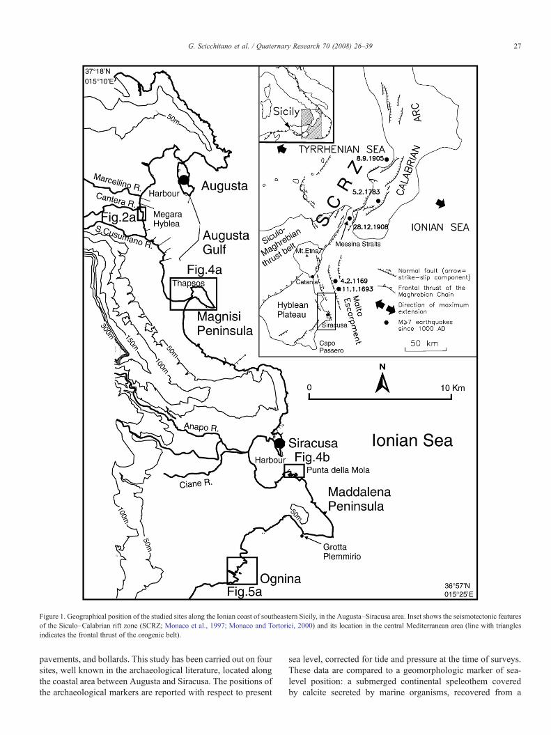
Figure 1. Geographical position of the studied sites along the Ionian coast of southeastern Sicily, in the Augusta–Siracusa area. Inset shows the seismotectonic featuresof the Siculo–Calabrian rift zone (SCRZ; Monaco et al., 1997; Monaco and Tortorici, 2000) and its location in the central Mediterranean area (line with trianglesindicates the frontal thrust of the orogenic belt).
27G. Scicchitano et al. / Quaternary Research 70 (2008) 26–39
pavements, and bollards. This study has been carried out on foursites, well known in the archaeological literature, located alongthe coastal area between Augusta and Siracusa. The positions ofthe archaeological markers are reported with respect to present
sea level, corrected for tide and pressure at the time of surveys.These data are compared to a geomorphologic marker of sea-level position: a submerged continental speleothem coveredby calcite secreted by marine organisms, recovered from a

28 G. Scicchitano et al. / Quaternary Research 70 (2008) 26–39
submarine cave south of Siracusa. This study provides new datato constrain the rate of sea-level rise during the late Holoceneand on the rate of the vertical movements of a land located in atectonically active area.
Tectonic setting
Southeastern Sicily (Fig. 1) is characterized by thickMesozoicto Quaternary carbonate sequences and volcanics forming theemerged foreland of the Siculo–Maghrebian thrust belt (Grassoand Lentini, 1982). This area, mostly constituted by the HybleanPlateau, is located on the footwall of a large normal fault systemwhich since the middle Pleistocene has reactivated the MaltaEscarpment (Bianca et al., 1999), a Mesozoic boundary sepa-rating the continental domain from the oceanic crust of the Ionianbasin (Scandone et al., 1981; Sartori et al., 1991;Hirn et al., 1997).
Since the early-middle Pleistocene, active faulting hascontributed to continuous extensional deformation from easternSicily to western Calabria (Siculo–Calabrian rift zone, Figure 1;Monaco et al., 1997; Bianca et al., 1999; Monaco and Tortorici,2000; Jacques et al., 2001). In eastern Sicily the SSW–NNEstriking normal faults are mostly located offshore and controlthe Ionian coast from Messina to the eastern lower slope of Mt.Etna, joining southwards to the NNW–SSE trending system ofthe Malta Escarpment (Fig. 1). This area is marked by a highlevel of crustal seismicity producing earthquakes with inten-sities of up to XI–XII MCS and M~7, such as the AD 1169,1693 and 1908 events (Postpischl, 1985; Boschi et al., 1995).According to most of published geological data and numericalmodelling, the seismogenic source of these events should belocated in the Messina Straits and in the Ionian offshore (theMalta Escarpment) between Catania and Siracusa (Postpischl,1985; Piatanesi and Tinti, 1998; Valensise and Pantosti, 1992;Bianca et al., 1999; Monaco and Tortorici, 2000; Azzaro andBarbano, 2000; Tinti and Armigliato, 2003).
The development of the Siculo–Calabrian rift zone was cou-pled with a strong regional uplifting of Calabria and NortheasternSicily, which progressively decreases toward the north and thesouth, spectacularly documented by flights of marine terracesdeveloped along the coasts (Cosentino and Ghiozzi, 1988;Westaway, 1993; Bordoni and Valensise, 1998; Ferranti et al.,2006). According to Westaway (1993), post-middle Pleistoceneuplift of southern Calabria was 1.67 mm/yr, 1 mm/yr of which isdue to regional processes and the residual to coseismic dis-placement. Regional uplifting could result either from stalling ofretreat of the Ionian subducted slab and consequent astheno-spheric flow into the gap resulting from slab detachment (Worteland Spakman, 2000; Goes et al., 2004) or from corner flow in theasthenosphere beneath a delaminated crust (Doglioni, 1991;Gvirtzman and Nur, 2001). The uplift has been locally accom-modated in the upper crust by repeated coseismic displacement;the highest values have been found in areas located in the footwallof the main active faults where a fault-related component iscyclically superimposed on the regional signal (Valensise andPantosti, 1992;Westaway, 1993; Bianca et al., 1999; Monaco andTortorici, 2000; Catalano and De Guidi, 2003; Catalano et al.,2003; Tortorici et al., 2003).
The Augusta–Siracusa area is located at the southern tip ofthe Siculo–Calabrian rift zone (Fig. 1). In this area the verticalcomponent of deformation has been recorded by several ordersof middle–upper Quaternary marine terraces and palaeo-shorelines (Di Grande and Raimondo, 1982), which indicatelong-term uplift rates of ~0.2 mm/yr in the last 125 ka(Antonioli et al., 2006) and 0.5–0.7 mm/yr in the last 400 ka(Bianca et al., 1999). This uplift rate gradually decreasestowards the stable areas of southeastern Sicily (Ferranti et al.,2006). No data reporting Holocene vertical uplift in the studiedarea are currently available in the literature. Only in the coastalarea of the Catania Plain, tens of kilometres to the north, short-term mean values of 0.5 mm/yr have recently been determined(Monaco et al., 2004). New data on late Holocene coastalmovements are provided in this paper.
Archaeological markers
Along the southeastern coast of Sicily, between Augusta andSiracusa (Fig. 1), four important archaeological sites, spanningthe period from the Bronze Age to the Greek archaic period,have been selected and investigated with the aim of evaluatingsignificant vertical movement along the coast. Evidence ofshoreline tectonic movement comes from the Bronze Agesettlements of Ognina and Thapsos, from the Greek archaicsettlement of Megara Hyblaea and from the coastal quarry ofPunta della Mola exploited during the Greek archaic period(Fig. 1). All of these sites contain valuable archaeologicalmarkers to deduce sea level change in the last millennia. ExceptMegara Hyblaea, archaeological knowledge on these sites isbased on the work of Orsi (1890, 1895) as no new substantialinvestigations have been undertaken in recent times (Leighton,1986 and references therein).
Materials and methods
Measurements of the current heights of significant archae-ological markers with respect to the current sea level at the timeof the survey were performed by an invar rod mechanicalsystem. Data have been corrected for tides and pressure relativeto mean sea level (MSL) using data from the tide gauges ofCatania [http://www.wxtide32.com] and from the meteorologi-cal site www.wunderground.com. We measured quarries,tombs, docks and piers.
To compare the archaeological structures and to relate themto ancient MSL, we defined their former functional height as aparameter to estimate sea-level change at each location. Thefunctional height is defined as the height of a specificarchitectural part of an archaeological structure with respect tothe mean sea level at the time of its construction and use. Thisdepends on the type of structure, its use, and the local tideamplitudes. These parameters also define the minimum heightof the structure above the local highest tides. With respect toharbour and dock structures, the functional heights of modernpiers and docks are in the range of 0.30 m above high tide,independent of the size of the harbour itself. This estimate is inagreement with the observations collected at other coastal

Table 1Location, elevation and age of the archaeological and geomorphologic markers
ASite
BCoordinates
CMeasurementdd/mm/yy
and local time
DMarker type,
measured elevation(m.b.s.l.)
EAge
(years BP)
FTide(m)
GPressure(hPa)/
correction (m)
HCorrectedelevation
(m)
IFunctionalheight(m)
LPalaeo-sea level
(m)
MPredictedsea level
(m)
NUplift Rate(mm/yr)
Megara Iblea 37°12.34′N15°11.60′E
15/06/06 –11:36 AM
“Banchinamento Orsi”−0.80
2600±100 −0.01 1020/−0.07 −0.88 0.60 −1.48 −2.25 0.30+ 0.03−0.04
Thapsos 37°09.53′N15°13.92′E
07/07/06 –12.56 AM
Tomb floor−0.40
3350±150 0.00 1016/−0.03 −0.43 ≥0.60 ≤−1.03 −3.29 ≤0.68±0.04
Punta della Mola 37°02.47′N15°18.42′E
14/06/06 –16:30 AM
Quarries−0.40
2600±100 0.07 1018/−0.05 −0.38 ≥0.60 ≤−0.98 −2.25 ≤0.49±0.03
Ognina 36°58.76N15°15.78′E
15/06/06 –08:25 AM
Tomb floor (dromos)−1.20
3500±300 0.06 1020/−0.07 −1.21 ≥0.60 ≤−1.81 −3.5 ≤0.49+ 0.09−0.10
36°58.80′N15°15.38′E
06/07/06 –08:00 PM
Channel sea-bottom−3.00
3500±300 0.11 1021/−0.08 −2.97 ≤−1.00 ≥−1.97 −3.5 ≥0.44±0.10
Plemmirio cave 37°00.25′N15°18.74′E
13/12/03 –06:00 AM
Serpulid overgrowthon stalagmite −20.3
8229±242 0.08 1013/0 −20.22 N/A ≤−20.22 −27.2 ≤0.78+0.32−0.33
Site in column A are also reported in Fig. 2; B: Coordinates (Lat/Long) of the surveyed site; C: day month, year, and hour of measurement; D: Type and field measurements (before correction) of the archaeologicalmarkers; E:Archaeological age of the sites; the 14C AMS dating of Serpulid fragment collected at the bottom of the Plemmirio Cave stalagmite was carried out at the Research School of Earth Sciences of The AustralianNational University, Canberra. Calibrated age was calculated using CALIB 5.0.1 (Stuiver et al., 2005); please refer to Dutton et al. (submitted) for raw data and methods. F: tidal correction applied for tide amplitude atthe moment of surveys; tide data (Catania) from http://wxtide32.com/version 4.6 (2006\6\30).G: atmospheric pressure and correction values at the time of surveys. Pressure data from http://www.wunderground.com;H:corrected elevation=D (measured elevation)+F (tide correction)+G (pressure correction); I: functional height of the used marker, with respect to the functional mean sea level; for quarries and tombs we assume aminimum elevation at 0.30 m above high tide (0.30 m) to be always dry, whereas the value of≤−1.0 m for the channel sea bottom depends on the ship draught; L: estimated relative sea level at the time of settlement=H(corrected elevation)− I (functional height);M: predicted sea level is computed as the average of predictions for Pachino and Catania Plain from the Lambeck et al. (2004b) model. These two sites bracket the location ofthe studied sites, with Catania plain just to the north and Pachino to the south of the study area; N: uplift rates are reported considering the age error bars and uniform uplift over the entire period of time considered, andhence represent time-averaged estimates.
29G.Scicchitano
etal.
/Quaternary
Research
70(2008)
26–39

Figure 2. a) Sketch map of the archaeological site of Megara Hyblea (see Fig. 1 for location); the position of the submerged “Banchinamento Orsi” harbour pier isshown; b) plan and c) cross-section of the “Banchinamento Orsi” harbour pier (from Villard and Vallet, 1953).
30 G. Scicchitano et al. / Quaternary Research 70 (2008) 26–39
archaeological sites (Lambeck et al., 2004a; Antonioli et al.,2007). Taking into account a maximum tide of about 0.30 m inthe Ionian coast of eastern Sicily, a functional height of 0.60 mwith respect to mean sea level is estimated (Table 1). Moreoverthese coastal structures were used by ships with a possibledraught of about 1.0 m (Kapitaen, 2002; Castagnino Berlin-ghieri, 2002, 2003). For quarry platforms and rock-cut tombs(presently submerged or partially submerged), we also assume aminimum elevation of their original floor at 0.30 m above hightide to be always dry, which suggests a minimum functionalheight of 0.60 m with respect to mean sea level.
Further on, the four distinct archaeological sites will bedescribed following their location along the coastline, from thenorth to the south (Fig. 1).
Megara Hyblaea
Megara Hyblaea (Orsi, 1890; Cavallari, 1892) is an ancientGreek colony built alongside a large Quaternary calcareniteplateau (A.A.V.V., 1987) facing the Augusta Gulf, at anelevation of 10–15 m above sea level (Figs. 1 and 2). It islocated inside the modern Augusta harbour between two rivers,the Cantera to the north and the San Cusumano to the south.Although debate about the location of the ancient harbor of the
Figure 3. a) Underwater view of the “Banchinamento Orsi” harbour pier (see Fig. 2a flocation); c) view of the Punta della Mola partially submerged quarry (see Fig. 4b for l(see Fig. 1 for location); the submerged channel and isthmus connecting the islet to thein the Ognina islet (see Fig. 5a for location); f) underwater view of the dromos of the tthe Ognina channel (see Fig. 5a for location); h) 1-m-high stalagmite in the third ro
Greek colony still persists, a few considerations about thecoastline and its landscape may shed some light on coastalmodifications that occurred during the last millennia. Even bysimple comparison with 16th to 19th century cartography (Gras,1995) it is evident that the ancient coastline north of thearcheological site formed a more pronounced bay than now.This is mainly due to the construction of two modern piers in theAugusta harbour, which are responsible for a huge accumula-tion of sediment transported by the rivers Marcellino andCantera (Fig. 1). Gravity driven processes are also evident alongthe slope of the plateau, especially in the northeastern andsoutheastern corners, where the Greek Archaic temples “C” and“ZR” (Gras et al., 2004), respectively, have been partiallydestroyed by landslides triggered by marine erosion (Fig. 2a).
The most significant archeological marker is a submergedstone structure, at about 4 m off the present coastline near thenortheastern corner of the plateau (Fig. 2a), previously observedby foreign visitors (Houel, 1785; Schubring, 1864) and firstanalyzed by Orsi (1890) who was able to recognize it during anexceptional low-tide episode. This stone structure (“banchina-mento”), later reconsidered by Villard and Vallet (1953) andGras (1995), was interpreted as a harbour pier because oflocation, block typology, and building technique. It is 24.50 mlong and 5.30 m wide (Fig. 2b) and it was built in the so called
or location); b) view of the partially submerged tomb of Thapsos (see Fig. 4a forocation); d) satellite image (from Google Earth) of the Ognina archaeological sitemainland are evident; e) entrance of the partially submerged dromos of the tombomb in the Ognina islet; g) partially submerged bollard along the southern pier ofom of the Plemmirio cave at ~−20 m depth (see Fig. 6 for location).

31G. Scicchitano et al. / Quaternary Research 70 (2008) 26–39

Figure 4. a) Sketch map of the archaeological site of Thapsos (see Fig. 1 for location); the position of the partially submerged tomb is shown; b) sketch map of Puntadella Mola in the Maddalena Peninsula (see Fig. 1 for location), showing the location of the partially submerged old Greek quarries.
32 G. Scicchitano et al. / Quaternary Research 70 (2008) 26–39
“Greek style” technique that is typical of landing or militarystructures of the Greek world. This technique is characterisedby the use of large parallelepiped calcarenite blocks (Fig. 3a),as long as 1 m and without any joins or transversal blocks,arranged in four overlapping rows (Fig. 2c): the first one seemsto be placed straight on the rocky seabed and no foundationlevel has been detected; the second one forms a largesubmerged platform. In the eastern sector, the sea bottomrelative to the second row is 1.20 m deep at the pier foot and0.80 m (corrected height −0.88 m) at the pier head (Table 1).Although only part of the four rows of blocks is still in place,one might hypothesize the existence of a complete four-rowstructure; if we consider the top of the mentioned structure andits original functional surface, the palaeo-sea level should beat –1.48 m depth.
According to Villard and Vallet (1953), the submerged stonestructure, named “Banchinamento Orsi”, should be a portion ofa bigger complex (“portique à ailes”) connected with anotherstructure transversally located onshore (Fig. 2a), which is builtby stone blocks similar in size, but rather differently arranged intechnique. Recent studies (Gras, 1995; Tréziny, 2002; Graset al., 2004) interpreted the entire complex as a monumentalfountain (“fontaine du Cantera”) by comparison with similar oldGreek structures. Regardless of the interpretation of the entirestructure, the “Banchinamento Orsi” could well be a harbourpier area arranged since the Greek Archaic Age (2.5–2.7 ka) inorder to support a channel-harbour on the ancient mouth of theCantera river. In this context, the occurrence of the GreekArchaic temple “C” near the “Banchinamento Orsi” and therecent hypothesis of reconstruction with its entrance from the

Figure 5. a) Sketch map of the archaeological site of Ognina (see Fig. 1 for location); inset shows the islet with the position of the partially submerged tomb; b) crosssections of the emerged (A–B) and submerged (C–D) sectors of the Ognina channel.
33G. Scicchitano et al. / Quaternary Research 70 (2008) 26–39
coastline (Gras et al., 2004) should be reconsidered. Recentanalysis (Guzzardi et al., 2007) of votive offerings recoveredclose to the temple “C” have ascertained that this religiouscomplex was a sanctuary dedicated to Hera Ilithyia, the goddessof childbirth, and that is was almost certainly connected with anharbour located on busy maritime routes.
It is possible that a more accurate investigation with ultra-sound equipment, of the multi-beam profiling type, might find
something under the huge seaweed cover which hides possiblearchaeological remains or architectural details, which arecurrently difficult to identify. Further underwater archaeologicalprospecting carried out along this stretch of the sea floor hasrevealed the occurrence of an irregular structure, still understudy, built by means of several remnants of blocks and roughstones fully covered by seaweeds (Basile, 1995). It is locatedabout 22 m to the north of the “Banchinamento Orsi” at 1.20–

34 G. Scicchitano et al. / Quaternary Research 70 (2008) 26–39
1.40 m depth and has been interpreted as a sort of L-shapedjetty, but it could represent a break-water in front of the Canterariver mouth.
Thapsos
The Bronze Age settlement of Thapsos (Orsi, 1895; BernabòBrea, 1958, 1966a; Voza, 1972, 1973a,b) is located on theMagnisi Peninsula, in the middle of the Augusta Gulf, on thesouth of the harbour (Fig. 4a). The peninsula is formed by a flatand low (maximum 20 m above sea level [a.s.l.]) calcareoushorst (A.A.V.V., 1987), gently tilted to the east-northeast. It isconnected with the mainland by a low-lying sandy isthmus,which provides the site with sheltered leeward anchorages andlanding places.
In the eastern portion of the peninsula, three main clusters ofnecropolis of the Middle Bronze Age (3.5–3.2 ka) are scatteredon a rocky platform placed between 5 and 2 m a.s.l and gentlysloping towards the sea. In the northern sector (Fig. 4a)numerous tombs, which yielded local grey hand-made potterytogether with Mycenean vessels, are partially flooded due to acombination of winds, waves, and currents that generate roughseas. This particular circumstance was first perceived by Orsi(1895) and recently reconsidered (Basile et al., 1988) but nodetailed investigation has been undertaken on site. The bestknown type of necropolis is the one of rock-cut tomb carveddirectly into the bedrock to create a small artificial cave withone, or sometimes more, sub-circular chambers with domedceilings, which is evocative of an Aegean beehive tomb of thetholos type (Alberti, 2004). The architectural structure has arectangular opening with perimeter groove for fitting the stoneslab which shuts the tomb and is characterised by the presenceof a dromos (narrow corridor) in front of the entrance facing thesea. The majority of these tombs have been desecrated by tombrobbers; hence the original position of the grave goods remainsunknown. The architectural structure will eventually be ruinedby the waves on the eastern and northeastern side of thepeninsula.
Apart from some burials, which might show features causedby irregularities in the bedrock, in one case a tomb located onthe northeastern necropolis facing the sea (Fig. 4a) providesclear evidence of sea-level change. Similar to the other rock-cuttombs belonging to the northeastern cluster of necropolis, thistomb is now partially submerged (Fig. 3b) and its shape hasbeen heavily modified by various natural elements. The edge ofthe main sub-circular chamber and the series of niches cut out ofthe bedrock are clearly detectable, even if wave action haspartially eroded the ground plan and enlarged the originalprofile. The presence of part of the markedly arched vault,which is still visible in one side of the chamber, suggests that theceiling was domed. Since the vaulted ceiling is partiallycollapsed and the ground plan eroded, we can infer an altitudeof −0.40 m below the present day sea level for the ground planby comparison with other tombs of the same typology.Considering the corrected value of −0.43 m and the functionalheight, the palaeo-sea level should have been at ≤−1.03 mdepth (Table 1).
Punta della Mola (Maddalena Peninsula)
The Maddalena Peninsula (Fig. 1) is a calcareous horstgently tilted to the east-northeast, located south of the Siracusanatural harbour and formed by Miocene sediments that alongthe coast are unconformably covered by Pleistocene calcar-enites (A.A.V.V., 1987). On the northeastern sector of thepeninsula (Punta della Mola, Fig. 4b), conspicuous evidence ofextracted parallelepiped blocks reveals the existence of stonequarries (Fig. 3c) which were exploited during the GreekArchaic period (2.7–2.5 ka). Remnants of stone quarries downto a –1m depth have been reported by Lena and Basile (1986).Our survey in this area revealed the occurrence of four quarrieswhose floor is located at maximum corrected depths of 0.38 mbelow sea level, suggesting that the palaeo-sea level shouldhave been at ≤−0.98 m depth (Table 1).
Ognina
The Ognina area is located 10 km south of Siracusa and isformed by two small promontories (Fig. 5a). The coast is mostlycharacterized by rocky platforms, carved on Pleistocenecalcarenites (A.A.V.V., 1987), placed between 3 and 0.5 m a.s.l. and gently sloping seaward. The archaeological site wasmostly located on a former small peninsula (the main part is theOgnina island, Fig. 5a), connected to the mainland by a narrowrocky isthmus, which is now submerged (Fig. 3d). It is acomplex site with remnants of several archaeological phases,spanning the period from Neolithic to Byzantine. The positivestructures survive to a height of only 3 m on the top of the islet,whereas negative structures (carved straight out of the rock)endure both on the island as well as on the coastal mainland.Some of the archaeological evidence found at Ognina in apartially modified position with respect to the time of use hasalready been discussed in considerable detail as a signal for sea-level change (Kapitaen, 1970; Castagnino, 1993–1995; Basileet al., 1988). The submerged rocky isthmus provided in theantiquity the settlement with sheltered leeward anchorages andbeaching places, and it is still in place, from −0.20 m down to−3.30 m relative to the present sea level.
On the tiny offshore island of Ognina (Fig. 5a) a series ofpost-hole structures arranged in parallel alignments suggest thepresence of a settlement established during the Neolithic Age,while a stable Maltese trading center (Bernabò Brea, 1966b;Parker, 1980) flourished during the Bronze Age (3.8–3.2 ka).Close relationships with Malta are suggested by certain vesselswhich are matched with Tarxien (3.8–3.4 ka) and Borg inNadur (3.4–3.2 ka) cultures (Bernabò Brea, 1958) and whichreflect a series of long-distance contacts within an organisedsystem of maritime trade. Material evidence seems to suggestthat during the Bronze Age the island of Ognina was a genuinetrading post under the control of Malta. In the western sector ofthe islet (see inset in Fig. 5a), a partially submerged Bronze Agetomb of the rock-cut chamber type is carved in the calcarenites(Fig. 3e). This chamber is preceded by a long dromos with anelliptical opening, the floor of which is at −1.20 m (correctedheight −1.21 m) below the present sea level (Fig. 3f). Taking

35G. Scicchitano et al. / Quaternary Research 70 (2008) 26–39
into account the functional height, the palaeo-sea level shouldhave been at ≤−1.81 m depth (Table 1).
Further meaningful indicators of sea-level change come fromthe adjacent coastal mainland and are located along the channelas well as along the coast southward of Capo Ognina. Alongsidethe channel, several partially submerged bollards are carved intothe rock (Fig. 3g). Below the sea surface a bollard has beendetected which forms a small artificial mushroom shape, thefoot of that is 0.9 m below the present sea level (Fig. 5b). Thesea bottom inside the channel has been detected at maximum−3.00 m (−2.97 m corrected for tide and pressure; Table 1).Taking into account at least 1.0 m of ship draught (CastagninoBerlinghieri, 2003), the palaeo-sea level should have been≥−1.97 m depth. These two last data points are very significantif we relate them with the Bronze Age (3.8–3.2 ka) activity atthe site by the Maltese and other seafaring people, as attested byarchaeological evidence. It is worthwhile to note that thechannel extends to the east where it is completely submerged,with bottom reaching a depth of −13 m b.s.l. (Figs. 5a and c).
Along the edge of the channel (Fig. 5a) there are tracks(carraie), previously discussed by Castagnino (1993–1995),that show clear sign of erosion and part of which are collapsedby the southern side of the channel border. Although shapelessshards of amphorae and common ware have been recoveredfrom the submerged channel, it is rather difficult to assess thechronologic range of use, but it seems feasible to surmise thatthis road system was built to support the intense activity alongthe channel. Stone quarries are in fact located both on the northand on the south side of the present channel mouth; these are ofuncertain age and currently partially submerged with floorlocated at maximum depths of 0.30 m below sea level. Inaddition, a partially submerged furnace of uncertain age hasbeen found south of Capo Ognina (Fig. 5a).
Figure 6. Planimetric map of the Plemmirio cave (see Fig. 1 for location; f
Geomorphological markers
The coastal area of southeastern Sicily is characterized by theoccurrence of several strands of marine terraces formed bywave-cut surfaces and/or thin depositional platforms (DiGrande and Raimondo, 1982; Bianca et al., 1999). The inneredge of the terraced surfaces and the alignments of marinecaves, litophaga holes and notches carved in the coastal cliffs,often linked to palaeo-karstic levels, represent a remarkablerecord of the palaeo-shorelines formed at sea level duringmarine stillstands. The Quaternary period was marked by cyclicglacio-eustatic relative sea-level changes, which have beenreconstructed on the basis of variations of benthic foraminiferaoxygen isotopic ratios (Waelbroeck et al., 2002, and referencestherein). The eustatic sea level calculated for the last 450 kareached ~6 m above the present sea level during the lastinterglacial and about 130 m below the present sea level duringthe last glacial climax. This implies that strands of palaeo-shorelines may occur both inland, especially in uplifted regions,and in submerged areas if not buried by sediment accumulation.
The sea bottom offshore of the present Siracusa coastline ischaracterized by several submerged karstic caves, aligned at thebase of two main escarpments, the shallower one located atdepth between −9 and −12 m and −20 and −22 m, the deeperone located at depth between −20 and −25 m and −40 and−45 m (Scicchitano and Monaco, 2006). These morphologicalelements have been interpreted as the effect of late Pleistocenesea-level stillstands that are presently submerged as aconsequence of Holocene sea-level rise. Several speleothemshave been found inside the caves (Scicchitano and Monaco,2006), which may have been cyclically submerged during theQuaternary sea-level change. A stalagmite (Fig. 3h) wascollected from the “Plemmirio” cave (Fig. 6; Leonardi, 1994;
rom Leonardi, 1994), showing the location of the sampled stalagmite.

36 G. Scicchitano et al. / Quaternary Research 70 (2008) 26–39
Scicchitano and Monaco, 2006), located at a depth of −22 m atthe southeastern corner of the Maddalena Peninsula (Fig. 1).Absolute age determination of the last marine encrustation onthis speleothem was established using 14C AMS on a sampletaken from the base of the Serpulid crust coating the stalagmiteat −20.22 m corrected depth (8229±242 cal yr BP, Table 1).Because Serpulids colonize quite quickly after a cave becomesinundated (Antonioli et al., 2001), this age represents a precisetime estimate of cave submergence during the last transgression.
Implications with the Holocene relative sea level change andestimation of tectonic uplift
Sea levels along Italian coastlines, like elsewhere in theMediterranean, are subject to the isostatic response of the crustto glacial unloading of high-latitude continental ice sheetsduring the last deglaciation as well as to the loading of the oceanfloor by the meltwater (glacio-hydro-isostasy). This processoccurs at rates that are functions of the glacial history of the iceand of the rheology of the mantle (Lambeck and Purcell, 2005).In the Mediterranean, the glacio-isostatic response is one of anongoing collapse of a broad bulge that formed around the icesheet at the time of glacial loading and which extends into theeastern Mediterranean region. The hydro-isostatic response isone of the loading of the sea floor by glacial meltwater andsuperimposes a shorter wavelength spatial variability on themore regional glacio-isostatic response. The predominant con-sequence of the isostatic rebound is that sea level has continued
Figure 7. Comparison between predicted sea level curves calculated by Lambeck et aand geomorphologic markers (this study, Table 1). Sea level predictions are shownsquares, south of sites) to bracket the geographic position of the study area. Sea levelsea level of the Catania plain and Pachino predictions. Inset (B) shows close up of aboxes bears no spatial significance. Rectangles containing a dot in the center represe
to rise up until the present time along the entire length of theItalian coast at a rate that is a function of distance from thecentres of former maximum glacial load but that is also afunction of the coastal geometry. Note that we have notconsidered the numerical uncertainty in the sea-level predictionin our calculations because quantitative estimates through timefor each site are not available. These predictions should beconsidered robust, because they have been rigorously tested atmany sites, but are of course not entirely without error.
Last interglacial shorelines (e.g., marked by fossils, tidalnotches, and terraces) along tectonically stable coasts of Italy arefound at an altitude of 6±3 m (Ferranti et al., 2006). Using thisbenchmark, the extreme tip of southeastern Sicily appears to be astable region, whereas eastern Sicily coastal areas underwentstrong uplift (up to 1.4 mm/yr), gradually decreasing towards thesouth. During the Holocene, palaeo-shoreline observationsalong the Ionian coasts of northeastern Sicily (Firth et al.,1996; Stewart et al., 1997; De Guidi et al., 2003) and analysesfrom the lagoonal fossils sampled in the Catania Plain (Monacoet al., 2004), yield age–altitude results that suggest uplifting inthe order of 2.0 mm/yr (northeastern Sicily), 3.0 mm/yr (Mt.Etna active volcanic area) and 0.5 mm/yr (Catania Plain).
In the Siracusa area, submerged archaeological and geomor-phological markers indicate that in the last 8 ka, sea-level risewas faster than tectonic uplift. The tectonic contribution can beevaluated as the difference between the observed local palaeo-sea-level positions (Table 1) and the predicted sea-level curve forthe same locality (Lambeck et al., 2004b). Figure 7 illustrates
l. (2004b) for southeastern Sicily coast and elevation of observed archaeologicalfor the Catania plain (open squares, north of studied sites) and Pachino (filledpredictions for various uplift rates (dashed lines) are calculated using the averagerchaelogical markers. Width of rectangles represents age uncertainty; height ofnt maximum estimates of sea level and should sit at or above the dashed lines.

37G. Scicchitano et al. / Quaternary Research 70 (2008) 26–39
this comparison. The age of the marine encrustations on thePlemmirio stalagmite suggests that the cave was last submergedduring the Holocene transgression. The 14C date of the Serpulidcalcite collected at the base of the biogenic crust implies that therelative sea level was at or above −20.22 m depth by 8229±240 cal yr BP. Taking into account the predicted sea level at thattime (Table 1; Fig. 7) and the age error bar, a maximum uplift rateof 0.78+0.32−0.33 mm/yr can be calculated dividing theobtained corrected elevation by the calibrated age of the Ser-pulid sample.
The age and palaeo-sea level of the studied archaeologicalindicators have also been compared to the predicted sea-levelcurve. All uplift rates represent time-averaged values as theywere estimated assuming uniform uplift over the entire period oftime considered. A significant marker for identifying sea levelcomes from the Bronze Age tomb of Ognina islet, the floor ofwhich is at −1.21 m below the present sea level (Table 1).Taking into account that the palaeo-sea level was at least 0.60 mlower than the original floor, 0.30 m above high tide (+0.30 m)to be always dry, the relative sea level 3.5±0.3 ka ago shouldhave been at −1.81 m depth. Comparing this value with thepredicted sea level (Table 1; Fig. 7), we obtain a maximumuplift rate of 0.49+0.09−0.10 mm/yr for the last 3500 yr. The≤−1.03 m palaeo-sea level of the Thapsos tomb suggests amaximum uplift rate of 0.68±0.04 mm/yr.
These values can be compared to the Ognina channeltopography, which is characterized by sea-bottom maximumdepths of −2.97 m (corrected for tide and pressure) (Table 1;Fig. 5b). Given that in the Bronze Age (3.5 ka ago) the sea levelwas 3.5 m lower than the present (Lambeck et al., 2004b), itmeans that the channel bottom should have been emergent,unless tectonic uplift has occurred in the intervening time.Taking into account that the ships that used these coastalstructures could have had a possible draught of about 1.0 m(Kapitaen, 2003; Castagnino Berlinghieri, 2002) and assumingnegligible sedimentation accumulation since the Bronze Age,the relative sea level should have been not more than 1.97 mlower than the present, which might fit with the maritimetopography analysed. Correcting this value for the predicted sealevel (Table 1; Fig. 7), we obtain a minimum tectonic uplift ratefor this case of 0.44±0.10 mm/yr.
Another important marker is represented by the “Banchina-mento Orsi” in the archaeological site of Megara Iblea. The pierhead is located at −0.88 m and considering a functional height of0.6 m, the relative sea level should have been at −1.48 m depth2.6±0.1 ka ago. Comparing this value with the predicted sealevel (Table 1; Fig. 7), we obtain an uplift rate of 0.30+0.03−0.04 mm/yr for the last 2.6 ka. For that time period, the Puntadella Mola quarries can also be used for determining a tectoniccomponent in the relative sea level change. Their floor is locatedat a corrected maximum depths of 0.38 m below sea level andconsidering that the palaeo-sea level was at least 0.60 m lowerthan the anthropogenic platform (0.30 m above high tide to bealways dry), the relative sea level should have been at −0.98 mdepth 2.6±0.1 ka ago. Correcting this value for the predicted sealevel (Table 1; Fig. 7), we obtain a maximum uplift rate of 0.49±0.03 mm/yr for the last 2.6 ka.
All the observed data (Fig. 7) fall above the predicted sealevel curve of Lambeck et al. (2004b), indicating that the areahas been subjected to general uplift during the last 8 ka. Thepresent elevation of most of these archaeological sites impliesan uplift rate of ~0.4 mm/yr, with estimates from individualsites ranging from 0.30 to 0.68 mm/yr when compared to thelocal sea level predictions of Lambeck et al. (2004b). Theconsistency of calculated uplift values between sites indicatesthat they reflect a regional process and not localized settling orcollapse of structures. In contrast, the 14C age of the Serpulidcalcite encrusting the speleothem indicates a higher uplift rate of0.78 mm/yr, but note that this estimate has a larger error thanany of the archaeological sites.
The large range of possible uplift rates (between 0.46 and1.11 mm/yr, Table 1) that is calculated for this geomorphologicsea-level marker is mostly due to the fact that the sea-level curvehas a much steeper slope near 8 ka. Hence, our ability toconstrain a precise uplift rate on this data point is limited becausethe sea level is changing rapidly during this period. Therefore,we are left with two possible interpretations: (1) if we considerthe low end-member (0.46 mm/yr) uplift rate calculated for theSerpulid calcite, then this sea-level marker is in excellentagreement with the late Holocene archaeological data; or (2) ifwe consider the best estimate (0.78 mm/yr) or upper end-member (1.11 mm/yr) uplift rate calculated from the 14C data,then this scenario indicates that the uplift history in this region ispunctuated by episodic coseismic events superimposed upon thelonger-term gradual uplift. In general, the uplift values we havecalculated are similar to the Holocene uplift rate of 0.5 mm/yrrecently determined in the coastal sector of the Catania Plain(Monaco et al., 2004) and with the long-term uplift rate of0.65 mm/yr estimated for the last 400 ka (Bianca et al., 1999).
Conclusions
Precise measurements of submerged archaeological markersalong the southeastern Sicily coast, integrated with informationderived from a submerged speleothem, provide data on therelative movement between land and sea level during theHolocene. The main source of uncertainty is the depth range ofthe former functional heights of the submerged archaeologicalmarkers at the time of their construction. We consider ourinference that the minimum height of the archaeologicalstructure must sit above the local highest tides to be alwaysdry to be a robust parameter to determine the former functionalheights (see also Lambeck et al., 2004a; Antonioli et al., 2007).
While there is some heterogeneity in the uplift rates we havecalculated based on geomorphologic and archaeologicalobservations, we emphasize that these estimates are essentiallythe same if we consider the errors in associated ages and in theposition of the predicted sea level from the model. If, however,the heterogeneity in uplift rates is in fact real, it would confirmthe tight connection between long-term tectonic uplift andabrupt fault-related displacement in controlling recent crustalinstability in this area, which is located at the footwall of one ofthe most active seismogenic structure of the central Mediterra-nean (see also Bianca et al., 1999).

38 G. Scicchitano et al. / Quaternary Research 70 (2008) 26–39
Finally, the estimation of recent relative sea level movementis useful to provide a flooding hazard scenario for those civiland industrial settlements of the studied region located near thepresent sea level, where little relative sea level rise movementcould produce extensive coastline sea-flooding.
Acknowledgments
This work was financed by University of Catania funds(Resp. C. Monaco and L. Tortorici). We thank Marco Mancini,the other anonymous reviewer and the Editors for theircomments that helped to clarify some aspects of the work.
References
A.A.V.V., 1987. Carta Geologica della Sicilia sud-orientale. S.El.Ca., Firenze.Alberti, G., 2004. Contributo alla seriazione delle necropoli siracusane. In: La
Rosa, V. (Ed.), Le presenzemicenee nel territorio siracusano. Università degliStudi di Catania, Corso di Laurea in Scienze dei Beni Culturali (Siracusa).
Antonioli, F., Silenzi, S., Frisia, S., 2001. Tyrrhenian Holocene palaeoclimatetrends from spelean serpulids. Quaternary Sciences Reviews 20, 1661–1670.
Antonioli, F., Kershaw, S., Renda, P., Rust,D., Belluomini, G., Cerasoli,M., Radtke,U., Silenzi, S., 2006. Elevation of the last interglacial highstand in Sicily (Italy):a benchmark of coastal tectonics. Quaternary International 145–146, 3–18.
Antonioli, F., Anzidei, M., Lambeck, K., Auriemma, R., Gaddi, D., Furlani, S.,Orrù, P., Solinas, E., Gaspari, A., Karinja, S., Kovačić, V., Surace, L., 2007.Sea level change during the Holocene in Sardinia and in the North-easternAdriatic (Central Mediterranean sea) from archaeological and geomorpho-logical data. Quaternary Science Revue 26, 2463–2486.
Anzidei, M., Esposito, A., Antonioli, F., Benini, A., Tertulliani, A., Del Grande,C., 2006. I movimenti verticali nell’area di Briatico: evidenze da indicatoriarcheologici marittimi nell’area del terremoto del 1905. In: Guerra, I.,Bavaglio, A. (Eds.), 8 settembre 1905 Terremoto in Calabria. Deputazione diStoria Patria per la Calabria, Università della Calabria, Regione Calabria.
Azzaro, R., Barbano, S., 2000. Analysis of the seismicity of southeastern Sicily:a proposed tectonic interpretation. Annali di Geofisica 43, 171–188.
Basile, B., 1995. Sul porto di Megara Iblea e le antiche linee di costa delterritorio siracusano. Relazione presentata alla X Rassegna internazione diArcheologia Subacquea di Giardini Naxos.
Basile, B., Di Stefano, G., Lena, G., 1988. Landings, ports, coastal settlementsand coastlines in Southeastern Sicily from prehistory to late antiquity. In:Raban, A. (Ed.), Archaeology of Coastal Changes”, Proceedings of the FirstInternational Symposium “Cities on the Sea—Past and Present, 404. BARInternational Series, pp. 15–33.
Bernabo’ Brea, L., 1958. La Sicilia prima dei Greci. Il Saggiatore.Bernabo’ Brea, L., 1966a. Thapsos (Augusta-Siracusa): scavo di tombe nella
necropoli dell’età del Bronzo (XIV inizi XIII secolo a.C.). Bollettino d’Arte51, 113.
Bernabo’ Brea, B., 1966b. Abitato neolitico ed insediamento dell’età del Bronzonell’isola di Ognina (Siracusa) ed i rapporti tra Sicilia e Malta dal XVI alXIII sec. a.C. Kokalos 12, 40–69.
Bianca, M., Monaco, C., Tortorici, L., Cernobori, L., 1999. Quaternary normalfaulting in southeastern Sicily (Italy): a seismic source for the 1693 largeearthquake. Geophysical Journal International 139, 370–394.
Bordoni, P., Valensise, G., 1998. Deformation of the 125 kamarine terrace in Italy:tectonic implications. In: Stewart, I.S., Vita-Finzi, C. (Eds.), Coastal Tectonics.Geological Society of London Special Publication, 46, pp. 71–110.
Boschi, E., Ferrari, G., Ferrari, P., Guidoboni, E., Smriglio, G., Valensise, G.,1995. Catalogo dei forti terremoti in Italia dal 461 a.c. al 1980. IstitutoNazionale di Geofisica, S.G.A., Roma.
Caputo, M., Pieri, L., 1976. Eustatic variation in the last 2000 years in theMediterranean. Journal of Geophysical Research 81, 5787–5790.
Catalano, S., De Guidi, G., 2003. Late Quaternary uplift of northeastern Sicily:relation with the active normal faulting deformation. Journal of Geody-namics 36, 445–467.
Catalano, S., De Guidi, G., Monaco, C., Tortorici, G., Tortorici, L., 2003. Long-term behaviour of the Late Quaternary normal faults in the Straits of Messinaarea (Calabrian Arc): structural and morphological constraints. QuaternaryInternational 101–102, 81–91.
Castagnino Berlinghieri, E.F., 1993–1995. Ognina (Siracusa): Note PreliminariAll’indagine di TopografiaMarittima, 137–148. Klearchos, Taranto, pp. 5–13.
Castagnino Berlinghieri, E.F., 2002. Attività umana e assetto costiero nellaProtostoria eoliana: nuovi risultati di ricerca. Atti del Convegno Inter-nazionale Strumenti per la Protezione e la Valorizzazione del PatrimonioCulturale Marino nel Mediterraneo”, Università di Milano Bicocca,Università degli Studi di Palermo e Regione Siciliana, (Palermo–Siracusa2001), Milano, 23–35.
Castagnino Berlinghieri, E.F., 2003. Il contesto archeologico sottomarino diPignataro di Fuori: una testimonianza diretta dell’imprenditoria mercantileeoliana nell’età del Bronzo Antico. Atti della XXXV Riunione Scientifica:Le Comunità della Preistoria Italiana. Studi e Ricerche sul Neolitico e le Etàdei Metalli", Lipari, 2000, Volume II, Firenze, pp. 1043–1048.
Cavallari, F.S., 1892. LaTopografia.MegaraHyblaea, Storia, Topografia,Necropolie Anathemata”, Monumenti Antichi, I, 1889 (1892), coll, pp. 914–950.
Cosentino, D., Ghiozzi, E., 1988. Considerazioni sulle velocità di sollevamentodi depositi eutirreniani dell’Italia Meridionale e della Sicilia. MemorieSocietà Geologica Italiana 41, 653–665.
De Guidi, G., Catalano, S., Monaco, C., Tortorici, L., 2003. Morphologicalevidences of Holocene coseismic deformation in the Taormina area (NESicily). Journal of Geodynamics 36, 193–211.
Di Grande, A., Raimondo, W., 1982. Linee di costa pliopleistoceniche eschema litostratigrafico del Quaternario siracusano. Geologica Romana 21,279–309.
Doglioni, C., 1991. A proposal of kinematic modelling for W-dippingsubductions. Possible applications to the Tyrrhenian–Apennines system.Terra Nova 3, 423–434.
Dutton, A., Scicchitano, G., Monaco, C., Desmarchelier, J., Antonioli, F.,Lambeck, K., Esat, T.M., Fifield, L.K., submitted. Uplift rates defined by U-series ages of speleothems from submerged caves near Siracusa, Sicily(Italy). Submitted to Quat. Geochronol.
Ferranti, L., Antonioli, F., Mauz, B., Amorosi, A., Dai Pra, G., Mastronuzzi, G.,Monaco, C., Orrù, P., Pappalardo, M., Radtke, U., Renda, P., Romano, P.,Sansò, P., Verrubbi, V., 2006. Markers of the last interglacial sea level highstand along the coast of Italy: tectonic implications. Quaternary International145–146, 30–54.
Firth, C., Stewart, I., McGuire, W.M., Kershaw, S., Vita-Finzi, C., 1996. Coastalelevation changes in eastern Sicily: implications for volcano instability atMount Etna. In: McGuire, W.M., Jones, A.P., Neuberg, J. (Eds.), VolcanoInstability on the Earth and Other Planets. Geological Society of LondonSpecial Publication, 110, pp. 153–167.
Flemming, N.C., 1969. Archaeological Evidence for Eustatic Changes of SeaLevel and Earth Movements in the Western Mediterranean in the Last 2000Years, Special Paper Geological Society of America, 109, pp. 1–125.
Flemming, N.C., Webb, C.O., 1986. Tectonic and eustatic coastal changesduring the last 10,000 years derived from archaeological data. Zeits chrift furGeomorphologie., N.F. 62, 1–29.
Gras, M., 1995. Mégara Hyblaea avant Augusta. In: Signorina, Alla (Ed.), Unefontaine dans l’histoire. Mélange offerts à Noelle de la Blanchardière, Roma.
Gras, M., Tréziny, H., Broise, H., 2004. Mégara Hyblaea, 5. La Ville Archaïqued’une cité grecque de Sicile orientale. École Française de Rome.
Grasso, M., Lentini, F., 1982. Sedimentary and tectonic evolution of theeastern Hyblean Plateau (southeast Sicily) during Late Cretaceous toQuaternary times. Palaeogeography, Palaeoclimatology, Palaeoecology39, 261–280.
Goes, S., Giardini, D., Jenny, S., Hollenstein, C., Kahle, H.G., Geiger, A., 2004.A recent tectonic reorganization in the south-central Mediterranean. Earthand Planetary Science Letters 226, 335–345.
Guzzardi, L., Germanà, G., Mondo, A., 2007. Rinvenimenti nel Santuario sulporto di Megara Hyblaea. Atti del Convegno: Ceramica Attica da Santuaridella Grecia, della Ionia e dell’Italia”, Perugia 14–17 Marzo 2007.
Gvirtzman, Z., Nur, A., 2001. Residual topography, lithospheric structure andsunken slabs in the central Mediterranean. Earth and Planetary ScienceLetters 187, 117–130.

39G. Scicchitano et al. / Quaternary Research 70 (2008) 26–39
Hirn, A., Nicolich, R., Gallart, J., Laigle, M., Cernobori, L., 1997. Roots of Etnavolcano in faults of great earthquakes. Earth and Planetary Science Letters148, 171–191.
Houel, J., 1785. Voyage Pittoresque in Sicilie, III, pp. 68–69.Jacques, E., Monaco, C., Tapponnier, P., Tortorici, L., Winter, T., 2001. Faulting
and earthquake triggering during the 1783 Calabria seismic sequence.Geophysical Journal International 147, 499–516.
Kapitaen, G., 1970. Perlustrazioni sottomarine sulla topografia originaria e lasituazione portuale dell’abitato preistorico di Ognina (relazione preliminare1969). In Sicilia Archeologica, pp. 43–56.
Kapitaen, G., 2003. Come navigavano nel Neolitico, in ATTI della XXXVRiunione Scientifica “Le comunità della Preistoria italiana: studi e ricerchesul Neolitico e le età dei Metalli”, in memoria di Luigi Bernabò Brea (Lipari,2–7 giugno 2000), II, pp. 1037–1041, Firenze.
Lambeck, K., Anzidei, M., Antonioli, F., Benini, A., Esposito, E., 2004a. Sealevel in Roman time in the Central Mediterranean and implications formodern sea level rise. Earth and Planetary Science Letters 224, 563–575.
Lambeck, K., Antonioli, F., Purcell, A., Silenzi, S., 2004b. Sea level changealong the Italian coast for the past 10,000 yrs. Quaternary QuaternaryScience Reviews 23, 1567–1598.
Lambeck, K., Purcell, A., 2005. Sea level change in the Mediterranean Sea sincethe LGM: model predictions for tectonically stable areas. QuaternaryScience Reviews 24, 1969–1988.
Lajoie, K.R., 1986. Coastal tectonics. Active Tectonics. National AcademyPress, Washington, pp. 95–124.
Lena, G., Basile, B., 1986. Coastal geomorphology and exploration of lithicresources (latomies and limekilns) in the territory of Syracuse in ancienttime. Thalassa 117–122.
Leonardi, R., 1994. Contributo alla conoscenza delle grotte sommerse dellaPenisola della Maddalena (SR). Bollettino Accademia Gioenia ScienzeNaturali, Catania 27 (348), 599–620.
Leighton, R., 1986. Paolo Orsi (1859–1935) and the prehistory of Sicily.Antiquity 60, 15–20.
Monaco, C., Tortorici, L., 2000. Active faulting in the Calabrian arc and easternSicily. Journal of Geodynamics 29, 407–424.
Monaco, C., Tapponnier, P., Tortorici, L., Gillot, P.Y., 1997. Late Quaternary sliprates on the Acireale–Piedimonte normal faults and tectonic origin of Mt.Etna (Sicily). Earth and Planetary Science Letters 147, 125–139.
Monaco, C., Antonioli, F., De Guidi, G., Lambeck, K., Tortorici, L., Verrubbi,V., 2004. Tectonic uplift and sea-level change during the Holocene in theCatania Plain (eastern Sicily). Quaternaria Nova 8, 171–185.
Orsi, P., 1890. Megara Hyblaea. Monumenti Antichi dei Lincei, coll, pp. 757–761.Orsi, P., 1895. Thapsos, necropoli sicula con vasi e bronzi micenei. Monumenti
Antichi dei Lincei, VI, coll, pp. 89–150.Parker, A.J., 1980. Sicilia e Malta nel commercio marittimo dell’antichità.
Kokalos, XXVI–XXVII, pp. 726–729.Piatanesi, A., Tinti, S., 1998. A revision of the eastern Sicily earthquake and
tsunami. Journal Geophysical Research 103, 2749–2758.Pirazzoli, P.A., 1976. Sea level variations in the northwest Mediterranean during
Roman times. Science 194, 519–521.Postpischl, D., 1985. Catalogo dei terremoti italiani dall’anno 1000 al 1980.
CNR, Progetto Finalizzato Geodinamica, Graficoop, Bologna. 239 pp.
Sartori, R., Colalongo,M.L., Gabbianelli, G., Bonazzi, C., Carbone, S., Curzi, P.V.,Evangelisti, D., Grasso, M., Lentini, F., Rossi, S., Selli, L., 1991. Note stra-tigrafiche e tettoniche sul rise di Messina (Ionio nord-occidentale). Giornale diGeologia 53, 49–64.
Scandone, P., Patacca, E., Radoicic, R., Ryan, W.B.F., Cita, M.B., Rawson, M.,Che zar, H., Miller, E., Mckenzie, J., Rossi, S., 1981. Mesozoic andCenozoic rocks from Malta Escarpment (Central Mediterranean). A.A.P.G.Bulletin 65, 1299–1319.
Scicchitano, G., Monaco, C., 2006. Grotte carsiche e linee di costa sommerse traCapo Santa Panagia e Ognina (Siracusa, Sicilia sud-orientale). Il Quaternario19 (2), 187–194.
Schmiedt, G., 1966. Antichi porti d'Italia. I porti delle colonie greche.L'Universo, XLVI, pp. 253–296.
Schmiedt, G., 1972. Linea di costa della Sicilia orientale compresa fra lafoce del fiume Simeto ed il Capo Ognina. Il livello antico del Mar Tirreno, II,pp. 201–221.
Schubring, J., 1864. Umwanderung des Megarischen Meerbusens in Sizilien.Zeitschrift fur allgemeine Erdkunde, N.S. XVII, pp. 434–464.
Stewart, I., Cundy, A., Kershaw, S., Firth, C., 1997. Holocene coastal uplift inthe Taormina area, northeastern Sicily: implications for the southernprolongation of the Calabrian seismogenic belt. Jornal of Geodynamics24, 37–50.
Stuiver, M., Reimer, P.J., Reimer, R., 2005. Calib radiocarbon calibration,execute version 5.0.2 html. http://calib.qub.ac.uk/calib.
Tinti, S., Armigliato, A., 2003. The use of scenario to evacuate the tsunamiimpact in southern Italy. Marine Geology 199, 221–243.
Tortorici,G., Bianca,M.,DeGuidi,G.,Monaco, C., Tortorici, L., 2003. Fault activityand marine terracing in the Capo Vaticano area (southern Calabria) during theMiddle-Late Quaternary. Quaternary International 101–102, 269–278.
Tréziny, H., 2002. Urbanisme et voire das les colonies grecques archaïques de laSicile orientale. Pallas 58, 267–282.
Valensise, G., Pantosti, D., 1992. A 125 Kyr-long geological record of seismicsource repeatability: the Messina Straits (southern Italy) and the 1908earthquake (Ms 71/2). Terra Nova 4, 472–483.
Villard, F., Vallet, G., 1953. Megara Hyblaea, III. Les Fouilles de 1951, Parigi,pp. 23–27.
Voza, G., 1972. Thapsos, primi risultati delle più recenti ricerche. Atti della XIVRiunione Scientifica dell’Istituto Italiano di Preistoria e Protostoria, Firenze,pp. 175–204.
Voza, G., 1973a. Thapsos. Resoconto sulle campagne di scavo del 1970–1971.Atti della XV riunione Scientifica dell’Istituto Italiano di Preistoria eProtostoria, Firenze. 133 pp.
Voza, G., 1973b. Thapsos. In: Voza, G. (Ed.), Archeologia della Sicilia sudorientale. Napoli, pp. 30–52.
Waelbroeck, C., Labeyrie, L., Michel, A., Duplessy, J.C., McManus, J.F.,Lambeck, K., Balbon, E., Labracherie, M., 2002. Sea-level and deep watertemperature changes derived from benthic foraminifera isotopic records.Quaternary Science Reviews 21, 295–305.
Westaway, R., 1993. Quaternary uplift of Southern Italy. Journal of GeophysicalReseacrh 98, 21722–21741.
Wortel, M.J.R., Spakman, W., 2000. Subduction and slab detachment in theMediterranean-Carpathian region. Science 290, 1910–1917.