submissions to the new noosa plan: attachment 1 12
TRANSCRIPT

SUBMISSIONS TO THE NEW NOOSA PLAN: ATTACHMENT 1 12 SEPTEMBER 2019
Page 1 of 5
CONFIDENTIAL PROPOSED ZONE CHANGES AS A RESULT OF SUBMISSIONS
DOCUMENT INFORM ATION
ZONE MAP
CHANGE REASON
ZM-1 Revert 71 Tablelands Rd Cooran to the Rural zone rather than the Rural Residential zone.
The submitter requests the zone remain Rural to facilitate their home-based business and future aspirations.
ZM-3 Revert 53 Lorikeet Lane Cooroy to the Rural zone rather than the Rural Residential zone.
The submitter requests the zone remain Rural to facilitate their future aspirations
ZM-4 Revert Lot 0 on SP230081278 at 278 Lake Cooroibah Road, Lake Cooroibah to the Rural Residential zone rather than the Environmental Management and Conservation zone.
Rural Residential zone better reflects the existing zone, the tenure of the land and the physical characteristics of the common property parcel.
ZM-4 Change zonings for Johns Landing Nature reserve Lot 115 RP173075. The red zoning shows the portion to be excluded.
New zoning
Change to Recreation and Open Space Zone and Environment Management and Conservation Zone will bring the zones in alignment with the Nature Refuge Gazettal area
ZM-6 Revert Lot 103 on SP148789, off Leggetts Loop, Kin Kin to the Recreation and Open Space Zone rather than the Environmental Management and Conservation zone
Recreation and Open Space better reflects the existing zone and the use of the property.
ZM-6 Revert 53 Main Street, Kin Kin to the Local Centre zone rather than the Low Density Residential zone.
The Local Centre zone reflects the current zoning of the property and the owner’s aspirations for the site.
ZM-7 Change 25-27 Urunga Parade, Boreen Point from Low Density Residential to the Tourist Accommodation zone
Tourist Accommodation zone better reflects the long term history of the site as Le Bateau Ivre Guesthouse.
Special Meeting 12 September 2019 Attachment 1 to Item 1CONFIDENTIAL
CONFIDENTIALITY REMOVED 16 SEPTEMBER 2019
SUBMISSIONS TO THE NEW NOOSA PLAN: ATTACHMENT 1 12 SEPTEMBER 2019
Page 2 of 5
ZM-7 Change 27 Mango Lane Boreen Point from Low Density Residential to Tourist Accommodation Zone
Tourist Accommodation zone better reflects the long term history of the site as Lake Cootharaba Motel.
ZM-7 Change 10 Urangan Street, Boreen Point from the Recreation and Open Space zone to the Community Facilities Zone, annotated for Utility Installation.
This is the site of the water tank for community water supply for public facilities and firefighting purposes.
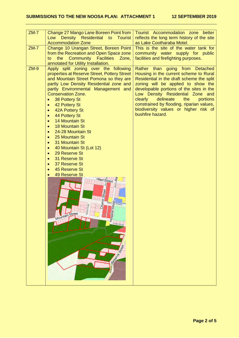
ZM-9 Apply split zoning over the following properties at Reserve Street, Pottery Street and Mountain Street Pomona so they are partly Low Density Residential zone and partly Environmental Management and Conservation Zone. • 38 Pottery St• 42 Pottery St• 42A Pottery St• 44 Pottery St• 14 Mountain St• 18 Mountain St• 24-28 Mountain St• 25 Mountain St• 31 Mountain St• 40 Mountain St (Lot 12)• 29 Reserve St• 31 Reserve St• 37 Reserve St• 45 Reserve St• 49 Reserve St
Rather than going from Detached Housing in the current scheme to Rural Residential in the draft scheme the split zoning will be applied to show the developable portions of the sites in the Low Density Residential Zone and clearly delineate the portions constrained by flooding, riparian values, biodiversity values or higher risk of bushfire hazard.

SUBMISSIONS TO THE NEW NOOSA PLAN: ATTACHMENT 1 12 SEPTEMBER 2019
Page 3 of 5
ZM-9 Change the following properties at Pomona to be zoned Low Density Residential rather than Rural Residential: • 41 Reserve St,• 43 Reserve St,• 51 Reserve St,• 38 Mountain St (Lot 11)
These blocks are either already used for low density housing or suitable for that use. They are between 1000m2 and 2800m2.
ZM-9 Change the zone of 12 School Street Pomona from the Community Facilities zone to the Medium Density Residential Zone.
As the site will not contribute to the operation of the bowls club or be used for any other community purpose it could add to housing choice close to the centre of town.
ZM-10 The split zoning of 86 Garnet Street Cooroy to be adjusted so a greater portion be included in the Low Density Residential zone.
There is more developable land than originally suggested by the Biodiversity Overlay and split zoning, and the boundary of the zone will be amended to better reflect constraints on site.
ZM-11 Include 73 Poinciana Avenue Tewantin in the Medium Density Residential Zone rather than the Community Facilities Zone.
While owned by the Catholic Church and adjoining the church, the current and intended use for this particular site is not place of worship but housing.
ZM-11 Include a further 3,000m2 (approx.) of 141 Cooroy Noosa Rd in the Medium Density Residential Zone as per the sketch below.
Owner of the site has requested that this portion of the site, once the original caretaker’s residence be added to the Medium Density Residential Zone, to facilitate additional relocatable homes.
ZM-11 Include 4, 6, 8 and 10 Carramar Street Tewantin in the Community Facilities Zone, specifically annotated for Residential Care Facility.
These sites have been purchased with the intent of expanding the residential care facility known as ‘Carramar’. Scheme provisions should require vehicular access to the expanded facilities be via Cooroy Noosa Road and not through the quiet residential street of Carramar Street.
SUBMISSIONS TO THE NEW NOOSA PLAN: ATTACHMENT 1 12 SEPTEMBER 2019
Page 4 of 5
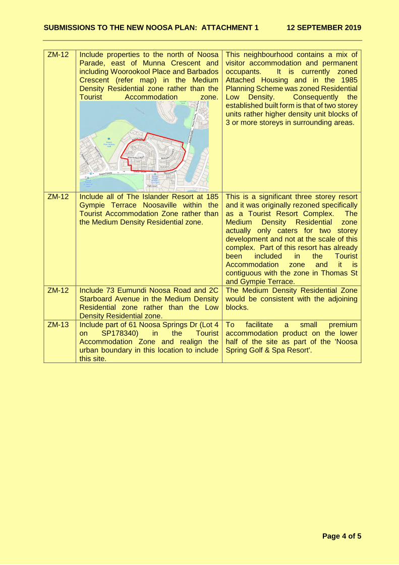
ZM-12 Include properties to the north of Noosa Parade, east of Munna Crescent and including Woorookool Place and Barbados Crescent (refer map) in the Medium Density Residential zone rather than the Tourist Accommodation zone.
This neighbourhood contains a mix of visitor accommodation and permanent occupants. It is currently zoned Attached Housing and in the 1985 Planning Scheme was zoned Residential Low Density. Consequently the established built form is that of two storey units rather higher density unit blocks of 3 or more storeys in surrounding areas.
ZM-12 Include all of The Islander Resort at 185 Gympie Terrace Noosaville within the Tourist Accommodation Zone rather than the Medium Density Residential zone.
This is a significant three storey resort and it was originally rezoned specifically as a Tourist Resort Complex. The Medium Density Residential zone actually only caters for two storey development and not at the scale of this complex. Part of this resort has already been included in the Tourist Accommodation zone and it is contiguous with the zone in Thomas St and Gympie Terrace.
ZM-12 Include 73 Eumundi Noosa Road and 2C Starboard Avenue in the Medium Density Residential zone rather than the Low Density Residential zone.
The Medium Density Residential Zone would be consistent with the adjoining blocks.
ZM-13 Include part of 61 Noosa Springs Dr (Lot 4 on SP178340) in the Tourist Accommodation Zone and realign the urban boundary in this location to include this site.
To facilitate a small premium accommodation product on the lower half of the site as part of the 'Noosa Spring Golf & Spa Resort'.
SUBMISSIONS TO THE NEW NOOSA PLAN: ATTACHMENT 1 12 SEPTEMBER 2019
Page 5 of 5
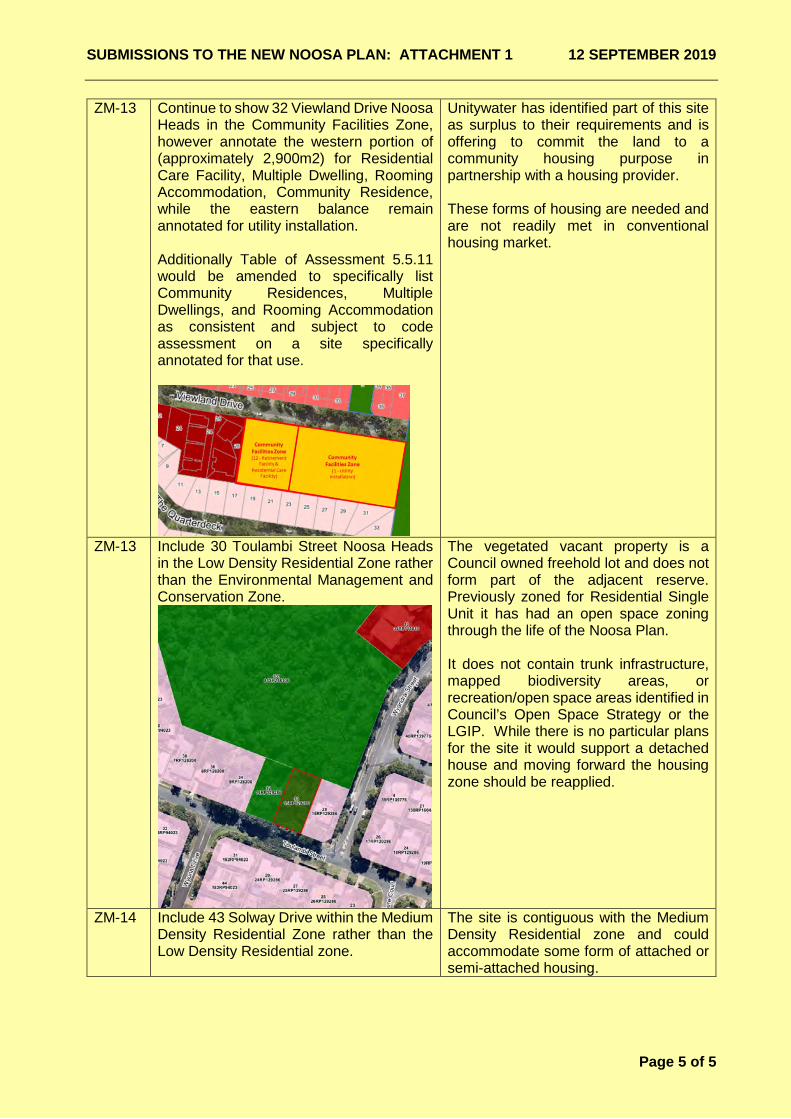
ZM-13 Continue to show 32 Viewland Drive Noosa Heads in the Community Facilities Zone, however annotate the western portion of (approximately 2,900m2) for Residential Care Facility, Multiple Dwelling, Rooming Accommodation, Community Residence, while the eastern balance remain annotated for utility installation.
Additionally Table of Assessment 5.5.11 would be amended to specifically list Community Residences, Multiple Dwellings, and Rooming Accommodation as consistent and subject to code assessment on a site specifically annotated for that use.
Unitywater has identified part of this site as surplus to their requirements and is offering to commit the land to a community housing purpose in partnership with a housing provider.
These forms of housing are needed and are not readily met in conventional housing market.
ZM-13 Include 30 Toulambi Street Noosa Heads in the Low Density Residential Zone rather than the Environmental Management and Conservation Zone.
The vegetated vacant property is a Council owned freehold lot and does not form part of the adjacent reserve. Previously zoned for Residential Single Unit it has had an open space zoning through the life of the Noosa Plan.
It does not contain trunk infrastructure, mapped biodiversity areas, or recreation/open space areas identified in Council’s Open Space Strategy or the LGIP. While there is no particular plans for the site it would support a detached house and moving forward the housing zone should be reapplied.
ZM-14 Include 43 Solway Drive within the Medium Density Residential Zone rather than the Low Density Residential zone.
The site is contiguous with the Medium Density Residential zone and could accommodate some form of attached or semi-attached housing.
Noosa Shire Planning Scheme
Part 5 Tables of Assessment
5.5 Categories of development and assessment—Material change of useThe following tables identify the categories of development and assessment for development in a zone or a precinct for making amaterial change of use.
Table 5.5.4 Tourist AccommodationUse Categories of development and assessment Assessment benchmarks for assessable
development and requirements for accepteddevelopment
Accommodation activities
Caretaker'saccommodation
Impact Assessment
If the gross floor area does not exceed 90m². The planning scheme
Community residence Impact assessment
The planning scheme
Multiple dwelling Impact assessment
If not located: Applicable Local Plan CodeTourist Accommodation Zone CodeDual Occupancy and Multiple Dwelling CodeWorks codes
within the Hastings Street Mixed UsePrecinct;
on Lot 77 SP231615, 215 David Low Way,Peregian Beach;
any lots on Lots 1 to 23SP190823,SP151409, 35 Morwong Drive, NoosaHeads (Viridian Noosa Resort);
on Lots 10 or 11 SP195871,3 – 7 SerenityClose, Noosa Heads (Settlers Cove Resortsite);
on Lot 203 SP267424 or Lot 8033SP203417 SP126203 , 94 Noosa Drive,Noosa Heads (RACV Resort);
on Lots 6 or 7 SP178340, 75105 ResortDrive, Noosa Heads;
on GTP102758, 73 Hilton Terrace,Noosaville (Ivory Palms Resort);
on SP115731 13 Hilton Terrace, Tewantin(Noosa Lakes Resort);
on Lot 2 RP135678, 1 Beach Road, NoosaNorth Shore;
on Lot 2 SP18616930, 30 Beach Rd,Noosa North Shore;
at Lot 500 SP215779, Lot 500 SP186174or is not any of the Beach Road HolidayHomes, 90 Beach Road, Noosa NorthShore;
on P190823 , SP151409, SP174665,
(a)
(b)
(c)
(d)
(e)
(f)
(g)
(h)
(i)
(j)
(k)
(l)
**Draft**New Noosa Plan for the purpose of Community Consultation Round 2 2019 Page 1 of 5
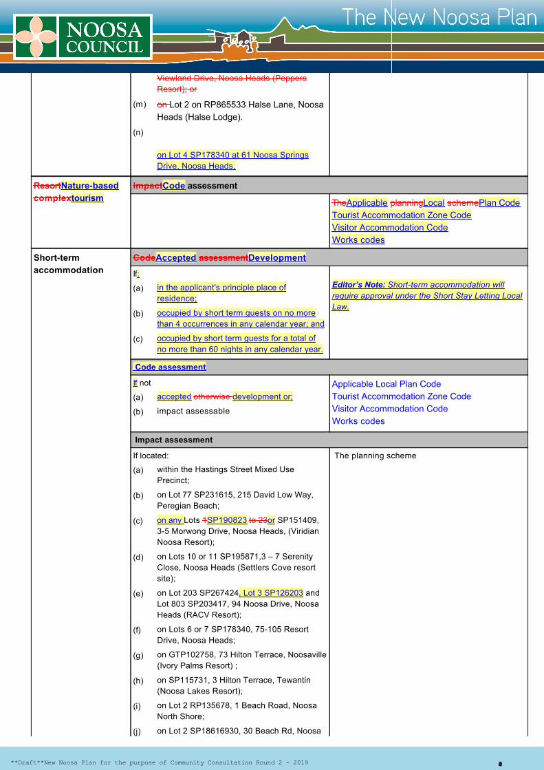
ResortNaturebasedcomplextourism
ImpactCode assessment
TheApplicable planningLocal schemePlan CodeTourist Accommodation Zone CodeVisitor Accommodation CodeWorks codes
Shorttermaccommodation
CodeAccepted assessmentDevelopment
If:Editor’s Note: Shortterm accommodation willrequire approval under the Short Stay Letting LocalLaw.
Code assessment
If not Applicable Local Plan CodeTourist Accommodation Zone CodeVisitor Accommodation CodeWorks codes
Impact assessment
If located: The planning scheme
Viewland Drive, Noosa Heads (PeppersResort); or
on Lot 2 on RP865533 Halse Lane, NoosaHeads (Halse Lodge).
on Lot 4 SP178340 at 61 Noosa SpringsDrive, Noosa Heads.
in the applicant's principle place ofresidence;
occupied by short term guests on no morethan 4 occurrences in any calendar year; and
occupied by short term guests for a total ofno more than 60 nights in any calendar year.
accepted otherwise development or;
impact assessable
within the Hastings Street Mixed UsePrecinct;
on Lot 77 SP231615, 215 David Low Way,Peregian Beach;
on any Lots 1SP190823 to 23or SP151409,35 Morwong Drive, Noosa Heads, (ViridianNoosa Resort);
on Lots 10 or 11 SP195871,3 – 7 SerenityClose, Noosa Heads (Settlers Cove resortsite);
on Lot 203 SP267424, Lot 3 SP126203 andLot 803 SP203417, 94 Noosa Drive, NoosaHeads (RACV Resort);
on Lots 6 or 7 SP178340, 75105 ResortDrive, Noosa Heads;
on GTP102758, 73 Hilton Terrace, Noosaville(Ivory Palms Resort) ;
on SP115731, 3 Hilton Terrace, Tewantin(Noosa Lakes Resort);
on Lot 2 RP135678, 1 Beach Road, NoosaNorth Shore;
on Lot 2 SP18616930, 30 Beach Rd, Noosa
(m)
(n)
(a)
(b)
(c)
(a)
(b)
(a)
(b)
(c)
(d)
(e)
(f)
(g)
(h)
(i)
(j)
**Draft**New Noosa Plan for the purpose of Community Consultation Round 2 2019 Page 2 of 5
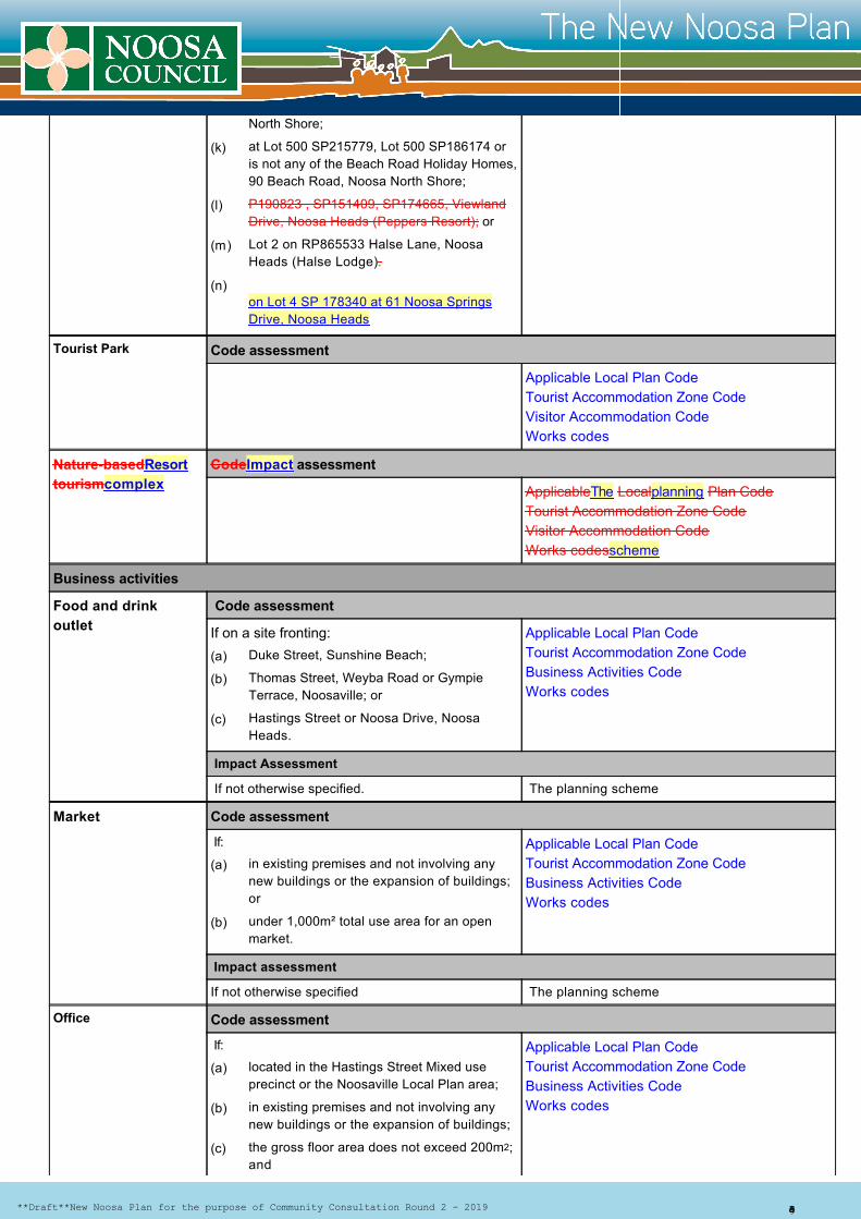
Tourist Park Code assessment
Applicable Local Plan CodeTourist Accommodation Zone CodeVisitor Accommodation CodeWorks codes
NaturebasedResorttourismcomplex
CodeImpact assessment
ApplicableThe Localplanning Plan CodeTourist Accommodation Zone CodeVisitor Accommodation CodeWorks codesscheme
Business activities
Food and drinkoutlet
Code assessment
If on a site fronting: Applicable Local Plan CodeTourist Accommodation Zone Code Business Activities Code Works codes
Impact Assessment
If not otherwise specified. The planning scheme
Market Code assessment
If: Applicable Local Plan CodeTourist Accommodation Zone CodeBusiness Activities Code Works codes
Impact assessment
If not otherwise specified The planning scheme
Office Code assessment
If: Applicable Local Plan CodeTourist Accommodation Zone CodeBusiness Activities Code Works codes
North Shore;
at Lot 500 SP215779, Lot 500 SP186174 oris not any of the Beach Road Holiday Homes,90 Beach Road, Noosa North Shore;
P190823 , SP151409, SP174665, ViewlandDrive, Noosa Heads (Peppers Resort); or
Lot 2 on RP865533 Halse Lane, NoosaHeads (Halse Lodge).
on Lot 4 SP 178340 at 61 Noosa SpringsDrive, Noosa Heads
Duke Street, Sunshine Beach;
Thomas Street, Weyba Road or GympieTerrace, Noosaville; or
Hastings Street or Noosa Drive, NoosaHeads.
in existing premises and not involving anynew buildings or the expansion of buildings;or
under 1,000m² total use area for an openmarket.
located in the Hastings Street Mixed useprecinct or the Noosaville Local Plan area;
in existing premises and not involving anynew buildings or the expansion of buildings;
the gross floor area does not exceed 200m2;and
(k)
(l)
(m)
(n)
(a)
(b)
(c)
(a)
(b)
(a)
(b)
(c)
**Draft**New Noosa Plan for the purpose of Community Consultation Round 2 2019 Page 3 of 5
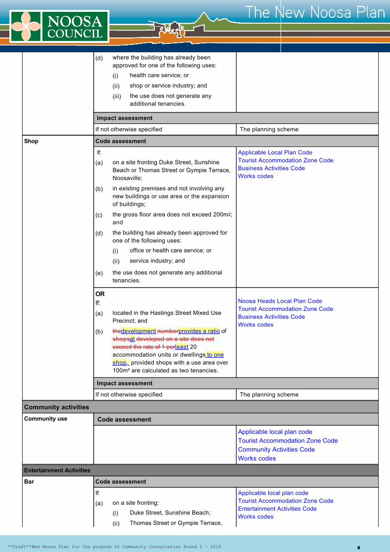
Impact assessment
If not otherwise specified The planning scheme
Shop Code assessment
If: Applicable Local Plan CodeTourist Accommodation Zone CodeBusiness Activities Code Works codes
OR If: Noosa Heads Local Plan Code
Tourist Accommodation Zone Code Business Activities CodeWorks codes
Impact assessment
If not otherwise specified The planning scheme
Community activities
Community use Code assessment
Applicable local plan codeTourist Accommodation Zone Code Community Activities Code Works codes
Entertainment Activities
Bar Code assessment
If: Applicable local plan codeTourist Accommodation Zone CodeEntertainment Activities CodeWorks codes
where the building has already beenapproved for one of the following uses:
health care service; or
shop or service industry; and
the use does not generate anyadditional tenancies.
on a site fronting Duke Street, SunshineBeach or Thomas Street or Gympie Terrace,Noosaville;
in existing premises and not involving anynew buildings or use area or the expansionof buildings;
the gross floor area does not exceed 200m2;and
the building has already been approved forone of the following uses:
office or health care service; or
service industry; and
the use does not generate any additionaltenancies.
located in the Hastings Street Mixed UsePrecinct; and
thedevelopment numberprovides a ratio ofshopsat developed on a site does notexceed the rate of 1 perleast 20accommodation units or dwellings to oneshop, provided shops with a use area over100m² are calculated as two tenancies.
on a site fronting:
Duke Street, Sunshine Beach;
Thomas Street or Gympie Terrace,
(d)
(i)
(ii)
(iii)
(a)
(b)
(c)
(d)
(i)
(ii)
(e)
(a)
(b)
(a)
(i)
(ii)
**Draft**New Noosa Plan for the purpose of Community Consultation Round 2 2019 Page 4 of 5
Impact assessment
If not otherwise specified. The planning scheme
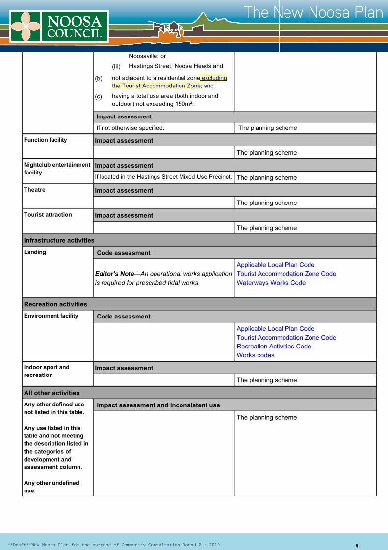
Function facility Impact assessment
The planning scheme
Nightclub entertainmentfacility
Impact assessment
If located in the Hastings Street Mixed Use Precinct. The planning scheme
Theatre Impact assessment
The planning scheme
Tourist attraction Impact assessment
The planning scheme
Infrastructure activities
Landing Code assessment
Editor’s Note—An operational works applicationis required for prescribed tidal works.
Applicable Local Plan CodeTourist Accommodation Zone Code Waterways Works Code
Recreation activities
Environment facility Code assessment
Applicable Local Plan CodeTourist Accommodation Zone Code Recreation Activities Code Works codes
Indoor sport andrecreation
Impact assessment
The planning scheme
All other activities
Any other defined usenot listed in this table.
Any use listed in thistable and not meetingthe description listed inthe categories ofdevelopment andassessment column.
Any other undefineduse.
Impact assessment and inconsistent use
The planning scheme
Noosaville; or
Hastings Street, Noosa Heads and
not adjacent to a residential zone excludingthe Tourist Accommodation Zone; and
having a total use area (both indoor andoutdoor) not exceeding 150m².
(iii)
(b)
(c)
**Draft**New Noosa Plan for the purpose of Community Consultation Round 2 2019 Page 5 of 5
Noosa Shire Planning Scheme
Part 6 Zones
6.3 Residential zones category
6.3.4 Tourist Accommodation Zone Code
ApplicationThis code applies to:
Purpose and overall outcomes
assessable development on land within the Tourist accommodation zone as identified on the zoning maps contained withinSchedule 2 (Mapping); and
acceptable development subject to requirements and identified as requiring assessment against the Tourist accommodationzone code by the tables of assessment in Part 5 (Tables of Assessment).
The purpose of the Tourist accommodation zone is to provide for:
shortterm accommodation; and
community uses, and smallscale services, facilities and infrastructure, to support shortterm accommodation andtourist attractions.
The overall outcomes sought for the Tourist accommodation zone are as follows:
Development provides for a mix of medium to high density visitor accommodation in the form of resorts, hotels andshortterm accommodation such as hostels and selfcontained holiday units.
Visitor accommodation in the urban areas is supported by a mix of business activities which create a vibrantatmosphere and complement and enhance the function and attractiveness of the area as a visitor destination. Cafes,restaurants, entertainment, function facilities and complementary shopping and personal services cater to the needs ofvisitors as well as Noosa Shire residents enjoying these areas.
Business activities are ancillary to visitor accommodation and should be of a nature and scale compatible with themixeduse character and coastal amenity of the area and not compromise the viability of the Noosa Shire centresnetwork by introducing activities at a scale that should be accommodated within a centre. No business uses areappropriate on 215 David Low Way, Peregian Beach.
Development contributes to the economy of the Shire through the tourism and hospitality sectors and integrates withnearby public recreation and open space, promoting low impact nature and waterbased recreation activities.
In urban areas development incorporates a high standard of urban and landscape design that creates attractive,functional buildings and places with active or landscaped streetscapes whilst maintaining a human scale at street level.
For the Noosa North Shore, development is low impact, low density and of a domestic scale within densely landscapedsettings reflecting the seclusion and values of Noosa North Shore. Buildings are designed to be in character with thenatural bushland setting of the locality with lightweight materials or colours that blend with the environment. Anybusiness activities established in the zone servicing tourists have low environmental impacts and are related torecreational experiences offered in the locality such as naturebased tourism.
Development incorporates a high level of residential amenity and safety and ensures that there is no unreasonable lossof amenity to surrounding premises.
The design of development ensures car parking does not visually dominate street frontages and promotes andfacilitates safe and accessible walking, cycling and public transport use where relevant.
Development enhances the experience of the specific features and values that attract tourists to the locality including theNoosa River, beaches and national parks.
Land adjacent to or in close proximity to Gympie Terrace, Noosaville offers ready access to the recreation opportunitiesof the Noosa River and vistas across the waterway.
Native vegetation between buildings and in the public realm enhances the amenity and supports local wildlife.
Development is supported by appropriate infrastructure and essential services and does not adversely impact on thecontinued operation, viability and maintenance of existing infrastructure or compromise future provision of plannedinfrastructure.
(a)
(b)
(1)
(a)
(b)
(2)
(a)
(b)
(c)
(d)
(e)
(f)
(g)
(h)
(i)
(j)
(k)
(l)
**Draft**New Noosa Plan for the purpose of Community Consultation Round 2 2019 Page 1 of 14

Hasting Street Mixed Use Precinct
Acceptable outcomes are provided for some, but not all, performance outcomes, and identify ways in which performanceoutcomes can be met. Compliance with the performance outcome should be demonstrated and the acceptable outcomes areconsidered as one way to satisfy the corresponding performance outcome.
Table 6.3.4.3 Criteria for assessment
Table 6.3.4.3 Criteria for assessment (part)
Performance Outcomes Acceptable Outcomes
Role and function
PO1Development provides a focus for visitor accommodation and arange of ancillary retail, food and beverage and entertainmentuses that contribute to the tourism focus of Noosa Shire.
No acceptable outcome provided.
PO2 Development provides for a range of visitor accommodationactivities and nonresidential uses accommodated in mixedusebuildings, where such activities are compatible with andancillary to the predominant functions of the zone as visitoraccommodation.
AO2Development provides for one or more of the following activitieswhich may be in conjunction with nonresidential uses in amixeduse building format:
PO3Business uses are secondary to accommodation uses andsupport recreational activities and surrounding accommodationfacilities without compromising or competing with Major Centresor District Centres.
AO3.1Businesses offer food and drink outlets, small scale retail andentertainment activities to residents and visitors.
AO3.2Banks, professional offices, supermarkets, discount departmentstores, showrooms, hardware stores and health care servicesdo not establish in the Tourist accommodation zone.
PO4 Development fronting Hastings Street, Gympie Terrace andDuke Street, reinforces the role of Noosa Shire as a majorcoastal tourism destination and visitor accommodation area,providing a range of smallscale boutique retail and outdoordining experiences with accommodation above, and strongvisual and pedestrian linkages with the beach and Noosa Riverforeshore area and nearby community uses.
No acceptable outcome provided
NoosavillePO5 AO5.1
Development sensitively responds to land constraints including topography, bushfire, flooding and storm surge whereapplicable.
Development is designed to respond to the subtropical climate of Noosa Shire and maximise energy efficiency andwater conservation and be resilient to future impacts of climate change.
The purpose of the zone will also be advanced through the following additional outcomes of the Hastings Street mixed useprecinct:
Development in the Hastings Street mixed use precinct is consistent with the existing built form and the particular mix ofaccommodation, dining, retail and other entertainment and services that have created such a a vibrant and successfulcentre dominated by independently operated local businesses.
Because Hastings Street has more intensive building forms than other areas within the Tourist accommodation zone,the protection of character, retention of existing trees and built form presentation to any public spaces about the site,including beaches and other waterways and parks, is of particular significance.
The Hastings Street mixed use precinct is identified as a destination suitable for much day time and night time activityincluding cafes, restaurants, bars and entertainment uses which generate late night noise.
resort accommodation;
shortterm accommodation.
(m)
(n)
(3)
(a)
(b)
(c)
(a)
(b)
**Draft**New Noosa Plan for the purpose of Community Consultation Round 2 2019 Page 2 of 14
Performance Outcomes Acceptable Outcomes
Development is predominantly of a residential nature toaccommodate visitors with ancillary uses limited to GympieTerrace, Thomas Street and Weyba Road.
Nonresidential uses are limited to Gympie Terrace, WeybaRoad and Thomas Street, where:
Hastings Street Mixed Use PrecinctPO6For Hastings Street Mixed Use Precinct uses above the groundfloor are predominantly of a residential nature to accommodatevisitors.
AO6.1The number of nonresidential tenancies developed on a sitedoesprovides nota exceed the rateratio of oneat perleast 20accommodation units or dwellings to one non residentialtenancy, provided that nonresidential usesshops with a usearea over 100m² are calculated as onetwo tenancy per 100m2 orpart thereoftenancies.
AO6.2New nonresidential uses are limited to the ground floor. Referto Figure 6.3.4.4 showing the mixeduse character outcomes forthe Hastings Street Mixed Use Precinct.
PO7The following sites are protected for the purpose of a resortcomplex or shortterm accommodation to the general exclusionof permanent residents:
No acceptable outcome provided.
Development has a nonresidential activity component ofno more than 20% of the gross floor area on the site;
The number of nonresidential tenancies developed on asite does not exceed the rate of one per 12accommodation units or dwellings, provided that nonresidential uses with a use area over 100m² arecalculated as one tenancy per 100m2 or part thereof; and
Nonresidential uses are limited to the ground floor.
located within the Hastings Street Mixed Use Precinct;
on Lot 77 SP231615, 215 David Low Way, PeregianBeach;
Lotsall 1lots toon 23SP15140 SP151409and SP190823,35 Morwong Drive, Noosa Heads, (Viridian NoosaResort);
on Lots 10 or 11 SP195871,3 – 7 Serenity Close, NoosaHeads (Settlers Cove resort site);
on Lot 203 SP267424 and Lot 803 SP203417, 94 NoosaDrive, Noosa Heads (RACV Resort);
on Lots 6 or 7 SP178340, 75105 Resort Drive, NoosaHeads;
on GTP102758, 73 Hilton Terrace, Noosaville (IvoryPalms Resort);
on SP115731, 3 Hilton Terrace, Tewantin (Noosa LakesResort);
on Lot 2 RP135678, 1 Beach Road, Noosa North Shore;
on Lot 2 SP18616930, 30 Beach Rd, Noosa North Shore;
at Lot 500 SP215779, Lot 500 SP186174 or is not any ofthe Beach Road Holiday Homes, 90 Beach Road, NoosaNorth Shore;
P190823, SP151409, SP174665, Viewland Drive, NoosaHeads (Peppers Resort); or
Lot 2 on RP865533 Halse Lane, Noosa Heads (HalseLodge).
(a)
(b)
(c)
(a)
(b)
(c)
(d)
(e)
(f)
(g)
(h)
(i)
(j)
(k)
(l)
(m)
**Draft**New Noosa Plan for the purpose of Community Consultation Round 2 2019 Page 3 of 14

Performance Outcomes Acceptable Outcomes
PO8Lot 77 SP231615, 215 David Low Way, Peregian Beachprovides for a diversity of shortterm accommodation types,including lowcost visitor accommodation, to cater for a range ofvisitor accommodation experiences.
No acceptable outcome provided
Table 6.3.4.3 Criteria for assessment (part)
Performance outcomes Acceptable Outcomes
Built form
Building HeightPO9Buildings and other structures:
AO9.1Buildings and other structures have a building height of no morethan:
AO9.2Where development involves excavation of a site, any portion ofan exposed external wall is backfilled to ground level.
Editor's note—refer to figure AP313A
Lot 4 on SP178340 at 61 Noosa Springs Drive, NoosaHeads.
are low rise and present a building height consistent withstructures on adjoining and surrounding premises;
do not visually dominate the street or surrounding areas;
preserve the amenity of surrounding premises includingprivacy, views and access to sunlight;
respect the scale of any nearby vegetation, retaining avegetated skyline;
respond to the topography of the site;
have a maximum building height of:
Noosaville– three storeys and appear no morethan three storeys from any elevation; or
Coastal Communities –
Sunshine Beach– three storeys and appearno more than three storeys;
Peregian Beach two storeys and appear nomore than two storeys from any elevation; or
Noosa Heads—three storeys and appear no morethan three storeys from any elevation with theexception of:
Lots 10 and 11 SP195871, Serenity Closewhere a maximum height of four storeys ispermitted and buildings appear no morethan four storeys from any elevation;
Lot 3 SP126203, Lot 203 SP267424,SP203417, 94 Noosa Drive and Lot 2 onRP865533, Halse Lane where a maximumheight of two storeys is permitted andbuildings appear no more than two storeysfrom any elevation;
the northern side of Hastings Street within 7metres of the Hastings St alignment – twostoreys and buildings appear no more thantwo storeys from any elevation; and balancearea of site four storeys and buildingsappear no more than four storeys from any
Noosa Heads– 12 metres with the exception of:
Lots 10 and 11 SP195871, Serenity Close wherebuilding height is no more than 15 metres; and
Lot 3 SP126203, Lot 203 SP267424, any lot onSP203417, 94 Noosa Drive and Lot 2 onRP865533, Halse Lane where building height isno more than 8 metres; and
the northern side of Hastings Street:
within 7 metres of the Hastings Stalignment – building height is no more than6 metres;
balance area of the site – building height isno more than 15 metres with a 12 metrespresentation to the beach; and
the southern side of Hastings Street:
within 10 metres of the Hastings St orNoosa Drive alignments – building height ofno more than 6 metres;
balance area of the site – building height of
no more than 15 metres; or
Noosaville and Sunshine Beach – building height of nomore than 12 metres; or
Noosa North Shore, Peregian Beach, Boreen Point andTewantin– building height of no more than 8 metres.
(n)
(a)
(b)
(c)
(d)
(e)
(f)
(i)
(ii)
(A)
(B)
(iii)
(A)
(B)
(C)
(a)
(i)
(ii)
(iii)
(A)
(B)
(iv)
(A)
(B)
(b)
(c)
**Draft**New Noosa Plan for the purpose of Community Consultation Round 2 2019 Page 4 of 14
Performance outcomes Acceptable Outcomes
SiteBuilding cover, plot ratioScale and gross floor areaBulkPO10Development:
No acceptable outcome provided
PO11 The maximum site cover does not exceed 40% unless in theHastings Street mixed use precinct where 45% is permitted.
No acceptable outcome provided
PO12 The maximum plot ratio does not exceed:
No acceptable outcome provided
Setbacks
elevation excluding where fronting the beachwhere buildings have a three storeypresentation to the beach; or
the southern side of Hastings Street within10 metres of the Hastings St or Noosa Drivealignments – two storeys and buildingsappear no more than two storeys from anyelevation; and balance area of the site – fourstoreys and buildings appear no more thanfour storeys from any elevation; or
Noosa North Shore, Boreen Point and Tewantin –two storeys and appear no more two storeys fromany elevation.
is of a scale compatible with surrounding developmentand the particular circumstances of the site; and
does not present an appearance of bulk to adjacentproperties, roads or other areas in the vicinity of the site.
In Noosa Heads –
1.12:1 of the site area if in the Hastings Streetmixed use precinct;
1:1 of the site area if on Lots 10 and 11 SP195871,Serenity Close;
0.4:1 of the site area if on SP190823, SP151409,SP174665, Viewland Drive;
0.4:1 of the site area if on Lots 6 and 7 onSP178340 Resort Drive being the Noosa Springs;
0.4:1 of the site area if on Lot 2 on RP865533,Halse Lane;
0.65:1 of the site area if on Lot 3 SP126203, Lot203 SP267424, SP203417, 94 Noosa Drive; or
0.65:1 of the site area where not listed above.
In Coastal Communities, Tewantin, Boreen Point andNoosaville – 0.65:1 of the site area.
On Noosa North Shore the gross floor area does notexceed
for 30 Beach Road, described as Lot 2 SP186169 2770m2;
for 90 Beach Road, described as Lot 500SP215779 3786m2;
otherwise no increase to gross floor area beyondbuildings in existence on the date of thecommencement of the planning scheme.
(D)
(iv)
(a)
(b)
(a)
(i)
(ii)
(iii)
(iv)
(v)
(vi)
(vii)
(b)
(c)
(i)
(ii)
(iii)
**Draft**New Noosa Plan for the purpose of Community Consultation Round 2 2019 Page 5 of 14
Performance outcomes Acceptable Outcomes
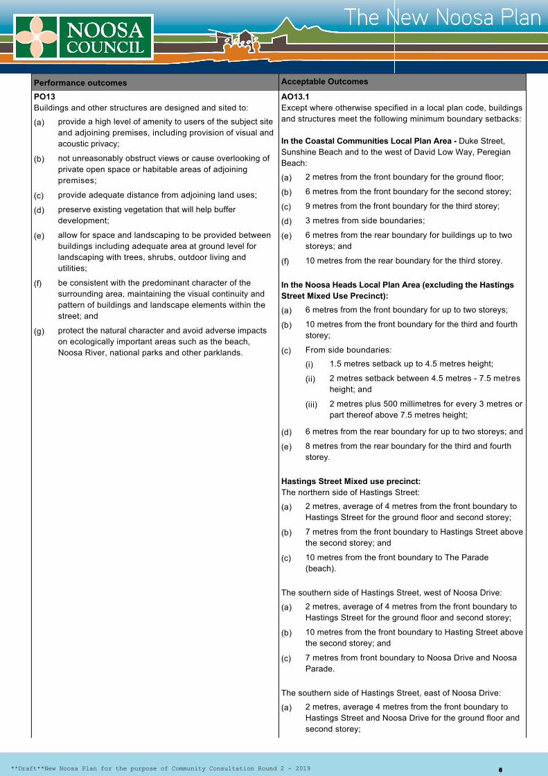
PO13Buildings and other structures are designed and sited to:
AO13.1Except where otherwise specified in a local plan code, buildingsand structures meet the following minimum boundary setbacks:
In the Coastal Communities Local Plan Area Duke Street,Sunshine Beach and to the west of David Low Way, PeregianBeach:
In the Noosa Heads Local Plan Area (excluding the HastingsStreet Mixed Use Precinct):
Hastings Street Mixed use precinct:The northern side of Hastings Street:
The southern side of Hastings Street, west of Noosa Drive:
The southern side of Hastings Street, east of Noosa Drive:
provide a high level of amenity to users of the subject siteand adjoining premises, including provision of visual andacoustic privacy;
not unreasonably obstruct views or cause overlooking ofprivate open space or habitable areas of adjoiningpremises;
provide adequate distance from adjoining land uses;
preserve existing vegetation that will help bufferdevelopment;
allow for space and landscaping to be provided betweenbuildings including adequate area at ground level forlandscaping with trees, shrubs, outdoor living andutilities;
be consistent with the predominant character of thesurrounding area, maintaining the visual continuity andpattern of buildings and landscape elements within thestreet; and
protect the natural character and avoid adverse impactson ecologically important areas such as the beach,Noosa River, national parks and other parklands.
2 metres from the front boundary for the ground floor;
6 metres from the front boundary for the second storey;
9 metres from the front boundary for the third storey;
3 metres from side boundaries;
6 metres from the rear boundary for buildings up to twostoreys; and
10 metres from the rear boundary for the third storey.
6 metres from the front boundary for up to two storeys;
10 metres from the front boundary for the third and fourthstorey;
From side boundaries:
1.5 metres setback up to 4.5 metres height;
2 metres setback between 4.5 metres 7.5 metresheight; and
2 metres plus 500 millimetres for every 3 metres orpart thereof above 7.5 metres height;
6 metres from the rear boundary for up to two storeys; and
8 metres from the rear boundary for the third and fourthstorey.
2 metres, average of 4 metres from the front boundary toHastings Street for the ground floor and second storey;
7 metres from the front boundary to Hastings Street abovethe second storey; and
10 metres from the front boundary to The Parade(beach).
2 metres, average of 4 metres from the front boundary toHastings Street for the ground floor and second storey;
10 metres from the front boundary to Hasting Street abovethe second storey; and
7 metres from front boundary to Noosa Drive and NoosaParade.
2 metres, average 4 metres from the front boundary toHastings Street and Noosa Drive for the ground floor andsecond storey;
(a)
(b)
(c)
(d)
(e)
(f)
(g)
(a)
(b)
(c)
(d)
(e)
(f)
(a)
(b)
(c)
(i)
(ii)
(iii)
(d)
(e)
(a)
(b)
(c)
(a)
(b)
(c)
(a)
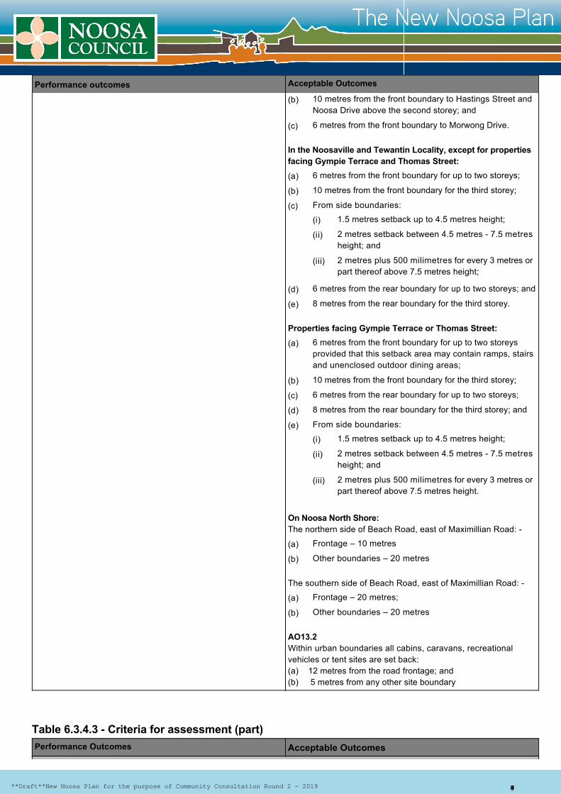
**Draft**New Noosa Plan for the purpose of Community Consultation Round 2 2019 Page 6 of 14
Performance outcomes Acceptable Outcomes
In the Noosaville and Tewantin Locality, except for propertiesfacing Gympie Terrace and Thomas Street:
Properties facing Gympie Terrace or Thomas Street:
On Noosa North Shore: The northern side of Beach Road, east of Maximillian Road:
The southern side of Beach Road, east of Maximillian Road:
AO13.2Within urban boundaries all cabins, caravans, recreationalvehicles or tent sites are set back:(a) 12 metres from the road frontage; and(b) 5 metres from any other site boundary
Table 6.3.4.3 Criteria for assessment (part)Performance Outcomes Acceptable Outcomes
10 metres from the front boundary to Hastings Street andNoosa Drive above the second storey; and
6 metres from the front boundary to Morwong Drive.
6 metres from the front boundary for up to two storeys;
10 metres from the front boundary for the third storey;
From side boundaries:
1.5 metres setback up to 4.5 metres height;
2 metres setback between 4.5 metres 7.5 metresheight; and
2 metres plus 500 milimetres for every 3 metres orpart thereof above 7.5 metres height;
6 metres from the rear boundary for up to two storeys; and
8 metres from the rear boundary for the third storey.
6 metres from the front boundary for up to two storeysprovided that this setback area may contain ramps, stairsand unenclosed outdoor dining areas;
10 metres from the front boundary for the third storey;
6 metres from the rear boundary for up to two storeys;
8 metres from the rear boundary for the third storey; and
From side boundaries:
1.5 metres setback up to 4.5 metres height;
2 metres setback between 4.5 metres 7.5 metresheight; and
2 metres plus 500 milimetres for every 3 metres orpart thereof above 7.5 metres height.
Frontage – 10 metres
Other boundaries – 20 metres
Frontage – 20 metres;
Other boundaries – 20 metres
(b)
(c)
(a)
(b)
(c)
(i)
(ii)
(iii)
(d)
(e)
(a)
(b)
(c)
(d)
(e)
(i)
(ii)
(iii)
(a)
(b)
(a)
(b)
**Draft**New Noosa Plan for the purpose of Community Consultation Round 2 2019 Page 7 of 14

Performance Outcomes Acceptable Outcomes
Design
StreetscapePO14Development:
AO14.1 Building design incorporates design elements to add visualinterest and amenity (such as windows, sun shading devices,balconies, varying railing treatments or a change of buildingmaterial).
Editor's note— refer to figure 6.3.2.4 and figure 6.3.2.5
AO14.2Development on site has the main pedestrian entrance easilyrecognisable from the street.
AO14.3Where fronting Gympie Terrace ofor Thomas Street spacesbetween the building and the road reserve is not used for carparking or vehicular manoeuvring.
AO14.4Where floor levels are raised to accommodate flooding orprojected sea level rise the building design must be designed toengage with the footpath by having an external terrace within thefront setback area that is set at an intermediate level betweenthe footpath and the main ground floor that is suitable foroutdoor trading, dining, seating or display of goods. An exampleis shown in Figure 6.3.4.5
AO14.5Development on corner sites address both streets by includingopenings, balconies and architectural features to bothfrontages. Figure AP37A shows corner treatment for buildingsrequiring active street frontages such as Hastings Street,Thomas Street and Gympie Terrace. AO14.6Development consists of small separate buildings rather thanlarge bulky buildings with no more than six units attached in oneplane.
AO14.7Buildings incorporate both vertical and horizontal articulationsuch that no unbroken elevation is longer than 15 metreswithout a change in plane of at least 750 millimetres.
AO14.8 Subtle changes in colours, textures and materials are used tobreak up the building facades and complement the naturalenvironment.
AO14.9On site development incorporates landscaping in front buildingsetback areas and footpath areas that is in character withexisting or planned streetscape themes.
Editor's note—refer to figure AP35A for example of landscapetreatments.
incorporates a high standard of architectural andlandscaping design and creates attractive and functionalbuildings, streets and places.
addresses and enhances the streetscape byincorporating articulation and individual design elementsthat add visual interest to the development;
provides nondiscriminatory access where floor levels areraised to meet flood immunity;
enables direct visual connection between the street,footpath and interior of the building where located onHastings Street, Gympie Terrace or Thomas Street;
makes the most of corner sites by addressing bothfrontages;
has a form and architectural scale that does not dominatethe streetscape or the surrounding properties;
does not detract from the visual amenity of adjoiningproperties such as the impact on views, access tosunlight or overlooking;
takes the form of small separate buildings, rather thanlarge single bulky development;
sits within a landscaped setting; and
visually screens site utilities or integrates them with thedesign of the development.
(a)
(b)
(c)
(d)
(e)
(f)
(g)
(h)
(i)
(j)
**Draft**New Noosa Plan for the purpose of Community Consultation Round 2 2019 Page 8 of 14
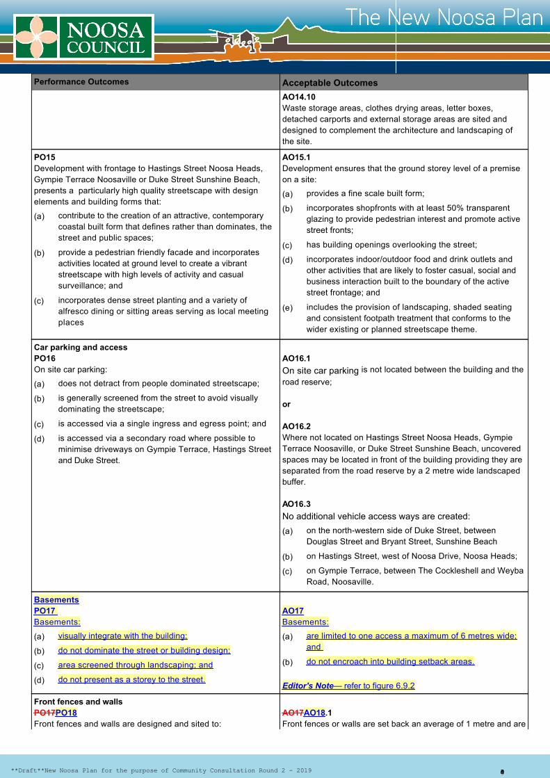
Performance Outcomes Acceptable Outcomes
AO14.10 Waste storage areas, clothes drying areas, letter boxes,detached carports and external storage areas are sited anddesigned to complement the architecture and landscaping ofthe site.
PO15 Development with frontage to Hastings Street Noosa Heads,Gympie Terrace Noosaville or Duke Street Sunshine Beach,presents a particularly high quality streetscape with designelements and building forms that:
AO15.1Development ensures that the ground storey level of a premiseon a site:
Car parking and accessPO16On site car parking:
AO16.1
On site car parking is not located between the building and theroad reserve;
or
AO16.2Where not located on Hastings Street Noosa Heads, GympieTerrace Noosaville, or Duke Street Sunshine Beach, uncoveredspaces may be located in front of the building providing they areseparated from the road reserve by a 2 metre wide landscapedbuffer.
AO16.3
No additional vehicle access ways are created:
BasementsPO17 Basements:
AO17Basements:
Editor's Note— refer to figure 6.9.2
Front fences and wallsPO17PO18Front fences and walls are designed and sited to:
AO17AO18.1Front fences or walls are set back an average of 1 metre and are
contribute to the creation of an attractive, contemporarycoastal built form that defines rather than dominates, thestreet and public spaces;
provide a pedestrian friendly facade and incorporatesactivities located at ground level to create a vibrantstreetscape with high levels of activity and casualsurveillance; and
incorporates dense street planting and a variety ofalfresco dining or sitting areas serving as local meetingplaces
provides a fine scale built form;
incorporates shopfronts with at least 50% transparentglazing to provide pedestrian interest and promote activestreet fronts;
has building openings overlooking the street;
incorporates indoor/outdoor food and drink outlets andother activities that are likely to foster casual, social andbusiness interaction built to the boundary of the activestreet frontage; and
includes the provision of landscaping, shaded seatingand consistent footpath treatment that conforms to thewider existing or planned streetscape theme.
does not detract from people dominated streetscape;
is generally screened from the street to avoid visuallydominating the streetscape;
is accessed via a single ingress and egress point; and
is accessed via a secondary road where possible tominimise driveways on Gympie Terrace, Hastings Streetand Duke Street.
on the northwestern side of Duke Street, betweenDouglas Street and Bryant Street, Sunshine Beach
on Hastings Street, west of Noosa Drive, Noosa Heads;
on Gympie Terrace, between The Cockleshell and WeybaRoad, Noosaville.
visually integrate with the building;
do not dominate the street or building design;
area screened through landscaping; and
do not present as a storey to the street.
are limited to one access a maximum of 6 metres wide;and
do not encroach into building setback areas.
(a)
(b)
(c)
(a)
(b)
(c)
(d)
(e)
(a)
(b)
(c)
(d)
(a)
(b)
(c)
(a)
(b)
(c)
(d)
(a)
(b)
**Draft**New Noosa Plan for the purpose of Community Consultation Round 2 2019 Page 9 of 14
Performance Outcomes Acceptable Outcomes
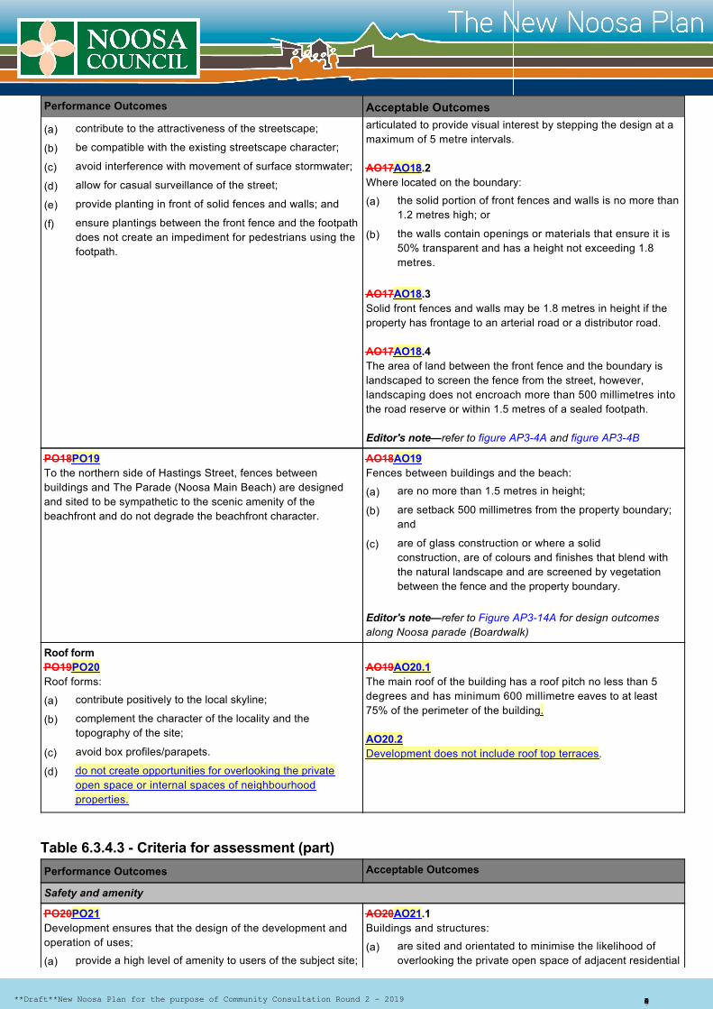
articulated to provide visual interest by stepping the design at amaximum of 5 metre intervals.
AO17AO18.2Where located on the boundary:
AO17AO18.3Solid front fences and walls may be 1.8 metres in height if theproperty has frontage to an arterial road or a distributor road.
AO17AO18.4The area of land between the front fence and the boundary islandscaped to screen the fence from the street, however,landscaping does not encroach more than 500 millimetres intothe road reserve or within 1.5 metres of a sealed footpath.
Editor's note—refer to figure AP34A and figure AP34B
PO18PO19To the northern side of Hastings Street, fences betweenbuildings and The Parade (Noosa Main Beach) are designedand sited to be sympathetic to the scenic amenity of thebeachfront and do not degrade the beachfront character.
AO18AO19Fences between buildings and the beach:
Editor's note—refer to Figure AP314A for design outcomesalong Noosa parade (Boardwalk)
Roof formPO19PO20Roof forms:
AO19AO20.1The main roof of the building has a roof pitch no less than 5degrees and has minimum 600 millimetre eaves to at least75% of the perimeter of the building.
AO20.2Development does not include roof top terraces.
Table 6.3.4.3 Criteria for assessment (part)
Performance Outcomes Acceptable Outcomes
Safety and amenity
PO20PO21Development ensures that the design of the development andoperation of uses;
AO20AO21.1Buildings and structures:
contribute to the attractiveness of the streetscape;
be compatible with the existing streetscape character;
avoid interference with movement of surface stormwater;
allow for casual surveillance of the street;
provide planting in front of solid fences and walls; and
ensure plantings between the front fence and the footpathdoes not create an impediment for pedestrians using thefootpath.
the solid portion of front fences and walls is no more than1.2 metres high; or
the walls contain openings or materials that ensure it is50% transparent and has a height not exceeding 1.8metres.
are no more than 1.5 metres in height;
are setback 500 millimetres from the property boundary;and
are of glass construction or where a solidconstruction, are of colours and finishes that blend withthe natural landscape and are screened by vegetationbetween the fence and the property boundary.
contribute positively to the local skyline;
complement the character of the locality and thetopography of the site;
avoid box profiles/parapets.
do not create opportunities for overlooking the privateopen space or internal spaces of neighbourhoodproperties.
provide a high level of amenity to users of the subject site;are sited and orientated to minimise the likelihood ofoverlooking the private open space of adjacent residential
(a)
(b)
(c)
(d)
(e)
(f)
(a)
(b)
(a)
(b)
(c)
(a)
(b)
(c)
(d)
(a)(a)
**Draft**New Noosa Plan for the purpose of Community Consultation Round 2 2019 Page 10 of 14
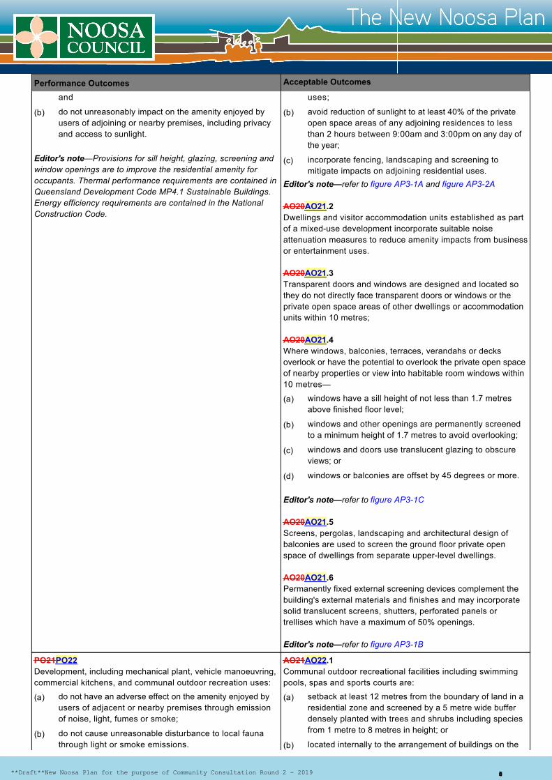
Performance Outcomes Acceptable Outcomes
Editor's note—Provisions for sill height, glazing, screening andwindow openings are to improve the residential amenity foroccupants. Thermal performance requirements are contained inQueensland Development Code MP4.1 Sustainable Buildings.Energy efficiency requirements are contained in the NationalConstruction Code.
Editor's note—refer to figure AP31A and figure AP32A
AO20AO21.2Dwellings and visitor accommodation units established as partof a mixeduse development incorporate suitable noiseattenuation measures to reduce amenity impacts from businessor entertainment uses.
AO20AO21.3Transparent doors and windows are designed and located sothey do not directly face transparent doors or windows or theprivate open space areas of other dwellings or accommodationunits within 10 metres;
AO20AO21.4Where windows, balconies, terraces, verandahs or decksoverlook or have the potential to overlook the private open spaceof nearby properties or view into habitable room windows within10 metres—
Editor's note—refer to figure AP31C
AO20AO21.5Screens, pergolas, landscaping and architectural design ofbalconies are used to screen the ground floor private openspace of dwellings from separate upperlevel dwellings.
AO20AO21.6Permanently fixed external screening devices complement thebuilding's external materials and finishes and may incorporatesolid translucent screens, shutters, perforated panels ortrellises which have a maximum of 50% openings.
Editor's note—refer to figure AP31B
PO21PO22Development, including mechanical plant, vehicle manoeuvring, commercial kitchens, and communal outdoor recreation uses:
AO21AO22.1Communal outdoor recreational facilities including swimmingpools, spas and sports courts are:
and
do not unreasonably impact on the amenity enjoyed byusers of adjoining or nearby premises, including privacyand access to sunlight.
uses;
avoid reduction of sunlight to at least 40% of the privateopen space areas of any adjoining residences to lessthan 2 hours between 9:00am and 3:00pm on any day ofthe year;
incorporate fencing, landscaping and screening tomitigate impacts on adjoining residential uses.
windows have a sill height of not less than 1.7 metresabove finished floor level;
windows and other openings are permanently screenedto a minimum height of 1.7 metres to avoid overlooking;
windows and doors use translucent glazing to obscureviews; or
windows or balconies are offset by 45 degrees or more.
do not have an adverse effect on the amenity enjoyed byusers of adjacent or nearby premises through emissionof noise, light, fumes or smoke;
do not cause unreasonable disturbance to local faunathrough light or smoke emissions.
setback at least 12 metres from the boundary of land in aresidential zone and screened by a 5 metre wide bufferdensely planted with trees and shrubs including speciesfrom 1 metre to 8 metres in height; or
located internally to the arrangement of buildings on the
(b) (b)
(c)
(a)
(b)
(c)
(d)
(a)
(b)
(a)
(b)
**Draft**New Noosa Plan for the purpose of Community Consultation Round 2 2019 Page 11 of 14

Performance Outcomes Acceptable Outcomes
AO21AO22.2For a lit sports court:
AO21AO22.3Outdoor or semienclosed common areas used for serving ordrinking alcohol, or designated outdoor smoking areas are:
AO21AO22.4Mechanical plant is:
Editor’s Note— Mechanical plant includes generators, motors,compressors and pumps such as airconditioning or poolequipment.
PO22PO23On site car parking areas are accessible to residents,customers, and staff during business hours.
AO22AO23.1Car parking spaces are accessible to residents, customers andstaff during business hours with security gating only operationalfor business uses outside of business hours.
site; and
not used between the hours of 9:00pm and 6:30am thefollowing day
the court is located at least 60 metres from the externalwall of an existing or approved dwelling on adjoining ornearby premises (as measured from the centre line of thecourt); and
the vertical illumination resulting from direct, reflectedor other incidental light emanating from the site doesnot exceed 8 lux when measured at any point 1.5metres outside the boundary and at any level fromground level upward; and
any floodlighting is restricted to the types that give noupward component of light where mounted horizontally(i.e. a full cut off luminare).
setback at least 15 metres from the boundary of land in aresidential zone and screened by a 5 metre wide bufferdensely planted with trees and shrubs including speciesfrom 1 metre to 8 metres in height; or
located internally to the arrangement of buildings on thesite.
located at least 2 metres from side or rear propertyboundaries;
where located at ground level, screened by fencing 1.5metres in height or dense vegetation of at least 1.5metres in width incorporating grouped trees and shrubswith a maximum separation distance of 1 metremeasured from the centre of the plant;
where located above ground level, enclosed or screenedsuch that it is not visible from the street frontage noradjoining properties; and
visually integrated into the line and plane of the buildingand roof design and does not project beyond the height orwidth of the building when viewed from the street andadjoining properties.
(c)
(a)
(b)
(c)
(a)
(b)
(a)
(b)
(c)
(d)
**Draft**New Noosa Plan for the purpose of Community Consultation Round 2 2019 Page 12 of 14
Performance Outcomes Acceptable Outcomes
PO22PO23.2Sufficient car parking spaces are allocated to resident guestsand guests are not competing with customers or patrons forparking spaces.
Table 6.3.3.3 Criteria for assessment (part)
Performance outcomes Acceptable Outcomes
Environment, heritage and scenic amenity
PO23PO24Development:
AO23AO24.1Cut or fill is less than 1.5 metres in depth relative to the groundlevel.
AO23AO24.2Development does not result in sediment or other materialincluding building materials or waste products being depositedor released into the road reserve, stormwater drain or adjacentproperties.
AO23AO24.3Development on a site adjoining a local heritage place respectsthe cultural heritage significance of the place by mitigating anyadverse impacts on the setting or integrity of the heritage values.
Editor’s Note—Local heritage places are identified on theHeritage and Character Areas Overlay maps in Schedule 2.
PO24PO25Development on sloping sites:
AO24AO25.1 Buildings and structures are not constructed on land with aslope greater than 25%.
AO24AO25.2Where slope gradients exceed 15%, splitlevel buildings, withsmall floorplates, that step down the slope are used as analternative to standard single or double storey construction tominimise building bulk and benching of the sites.
Editor's note Refer to Figure 6.9.1A and Figure 6.9.1B
AO24AO25.3 The distance between the ground level and the lowest part of thefloor of the building does not exceed 3 metres.
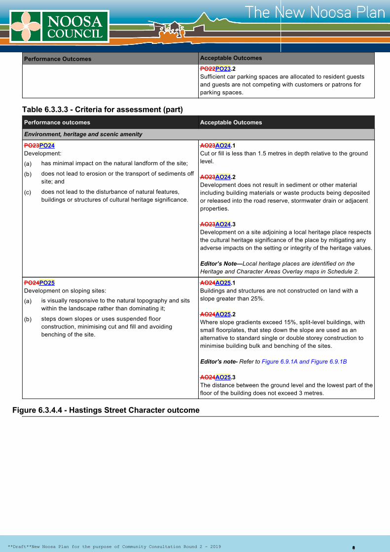
Figure 6.3.4.4 Hastings Street Character outcome
has minimal impact on the natural landform of the site;
does not lead to erosion or the transport of sediments offsite; and
does not lead to the disturbance of natural features,buildings or structures of cultural heritage significance.
is visually responsive to the natural topography and sitswithin the landscape rather than dominating it;
steps down slopes or uses suspended floorconstruction, minimising cut and fill and avoidingbenching of the site.
(a)
(b)
(c)
(a)
(b)
**Draft**New Noosa Plan for the purpose of Community Consultation Round 2 2019 Page 13 of 14
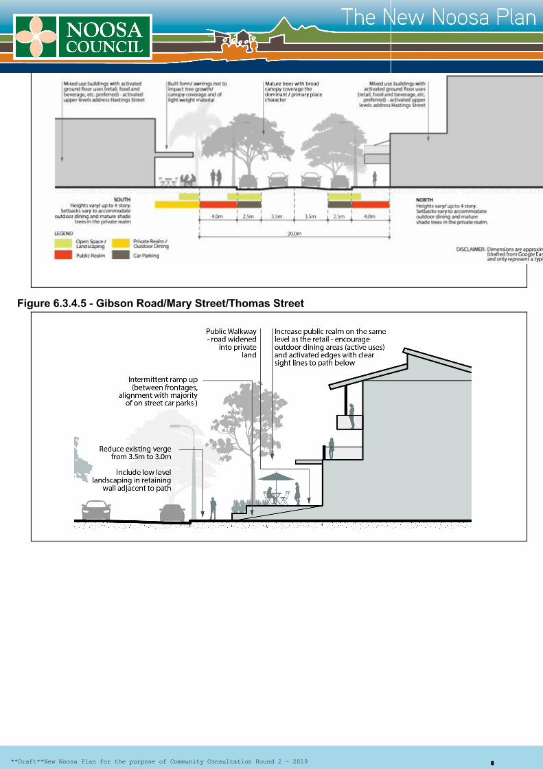
Figure 6.3.4.5 Gibson Road/Mary Street/Thomas Street
**Draft**New Noosa Plan for the purpose of Community Consultation Round 2 2019 Page 14 of 14