subsurface lithofacies and its geomorphic significance: a ... · the river teesta is a tributary to...
TRANSCRIPT
Subsurface lithofacies and its Geomorphic Significance: A Case Study of Teesta River, West
Bengal, IndiaRabin Chakrabortty1, Subodh Chandra Pal2, Sk Najrul Islam3, Biswajit Das1 and Sadhan Malik1
1Junior Research Fellow, Department of Geography, University of Burdwan, India2Assistant Professor, Department of Geography, University of Burdwan, India3West Bengal Police, Govt. of West Bengal, India
Submission: April 02, 2018; Published: April 23, 2018
*Corresponding author: Rabin Chakrabortty, Junior Research Fellow, Department of Geography, The University of Burdwan, India, Email:
IntroductionThe relationships between geomorphic features,
stratification and deposition of facies are very important to explain the characteristics of depositional behavior of sand [1]. Each and every years erosion take place, simultaneously new bar emerge such erosion and deposition are essential study area for the sedimentological research as the history of such deposition well recorded in such a modern river bars. Again the study of the sedimentary structures and the lithology is very important to determine the past depositional environment which is also supported by the grain size analysis and grain morphology [2]. The deposition of alluvium strata is one of the most important determining factors for predicting the climate over long periods. To estimate such factor (chemical, physical and biological), the quaternary sediment have been adopted for detailed measurement in a depositional environment [3-5]. Planform dynamics (spatial and temporal) are adjusted by their active meander. In a depositional environment the grain size studies have been established as almost important tools for detailed investigation [6-9]. In a depositional environment of braided river first of fall the facies type and facies association
have been adopted then it represented the depositional strata in coding system [10-15].
Sub-sequently work by others writers particularly that reported in this volume, has shown that the code system and the vertical profile models can both be usefully to analysis a wider range of depositional variability. The following brief discussion is offered as an attempt to integrate these new data in to the review published earlier and as an introduction to the more detailed papers on braided depositional models which to follow [16-18]. There is a strongly negative correlation between the incised natures of stream and sediment as well as water discharge [19]. The present status of Teesta are associazted with the mid channel bar of paleo channe l [20]. The paleo-flood records helps to understand the past depositional tricks and current position of depositional activities [21-26]. Facies association is a group of facies that accrue together and are considened to be genetically on environment only related, there by masking more information than a facies in isolation from its neighbours . The analysis of facies is then the fundamental to all environmental interpretations and paleo geographic reconstruction [27]. The
Int J Environ Sci Nat Res 10(2): IJESNR.MS.ID.555782 (2018) 001
Abstract
The relationships between geomorphic features, stratification and deposition of facies are very essential to make clear the characteristics of depositional activities of material. In every time erosion obtain place, simultaneously new bar emerge such erosion and deposition are essential study for sediment logical research. Facies is the scrupulous rock body and that is originated by the combination effort of litho logy, texture, structure and the prevailing nature of pale current. Noticeable attributes of a sedimentary rock body that reflect the depositional processes or environments that shaped facies. Some profiles have been drawn in dissimilar parts of the river by means of numerous parameters such as bedding, sedimentary structure, vertical profile, facies contacts etc. Litho logy and structure are the most imperative determining aspect of facies identification. For the study of Teesta River we divided upstream and downstream into three profiles. Profile 1, Profile 2 and Profile 3 have been taken for downstream and Profile 4, Profile 5 and Profile 6 have been taken for upstream. Profile 1, Profile 4 and Profile 2, Profile 5 has the similarities in term of facies description but far different from the Profile 3 and Profile 6. Top profile has been large depositional structure and the thickness of the beds is more than the Profile 2, Profile 5 and Profile 3, Profile 6. In recent times with the basis of construction of engineering structure past evidences ensuing the decreasing volume of river water flow.
Keywords: Facies; Paleo current; Lithology; Depositional structure etc
Research ArticleVolume 10 Issue 2 - April 2018DOI: 10.19080/IJESNR.2018.10.555782
Int J Environ Sci Nat ResCopyright © All rights are reserved by Rabin Chakrabortty

How to cite this article: Rabin C, Subodh C P, Sk Najrul I, Biswajit D, Sadhan M. Subsurface lithofacies and its Geomorphic Significance: A Case Study of Teesta River, West Bengal, India. Int J Environ Sci Nat Res. 2018; 10(2): 555782. DOI: 10.19080/IJESNR.2018.10.55578202
International Journal of Environmental Sciences & Natural Resources
present study laid emphasis of the sedimentary facies in different parts of river Teesta. For detailed investigation of depositional environment, the data of different profiles have been collect and analysed. The profile sections are predetermined by the satellite
images to reach to the location for the drawing the record of the respective facies sections. The profiles have been selected on the basis of identifying (with the help of satellite images) landforms types of different temporal periods Figure 1.
Figure 1: Location of the Study area.
Study Area The river Teesta is a tributary to the world’s largest sandy
braided river Brahmaputra which is known as the Jamuna in its lower reaches where it meets with the Padma in Bangladesh. From Pahunuri glacier in Sikkim the Teesta finds its way through the Darjeeling ridge in a narrow and deep George, and follows a meandering course thus providing the best cross section of the eastern Himalayas [28]. From Melli Bazar (West Bengal and Sikkim border) downstream 30 km., the river leaves the hilly terrain and enters the plains of West Bengal at Sevoke near Siliguri where the river becomes braided with sandy-gravel bars bifurcate multiple channels. Gazaldoba barrage is located 25 km. from the Sevoke and after Gazaldoba the river predominantly a sandy braided river. The river entered into Bangladesh after 75km. from the Gazaldoba Barrage. The study area focused on several reaches of the river.
This reaches are selected on the basis of the dominant island formation and development. It is spread up to Indo-Bangladesh border in the south and in the upstream the point where the river
debouches to the plain from the hill. But for the detailed analysis of the river facies of different sections of different time records the study reach have been divided into two broad sections. From the reference points of the Domohani Teesta Bridge in the 10 km upstream is called as Domohani upstream (DUS) while the 15 km downstream is identified as Domohani Downstream (DDS). In the mentioned reaches across the river total six profiles have been drawn from the cut bank exposure for the detailed study of the facies. The present work seeks to highlight and focus to identify the vertical depositional history of the identified landforms for the facies analysis and classify the dominant depositional sedimentary facies and their characteristics from the selected sections and their relative differences.
Research Method The methodology for lithofacies classification in account
the depositional behavior of the study area is similar to that developed by Miall [29] and Einsele [30] have been adopted for the present purpose. The detailed methodology of the study has given in the following (Figure 2).The vigorous field based

How to cite this article: Rabin C, Subodh C P, Sk Najrul I, Biswajit D, Sadhan M. Subsurface lithofacies and its Geomorphic Significance: A Case Study of Teesta River, West Bengal, India. Int J Environ Sci Nat Res. 2018; 10(2): 555782. DOI: 10.19080/IJESNR.2018.10.55578203
International Journal of Environmental Sciences & Natural Resources
study in the month of March, 2015 taken into consideration near Jalpaiguri town and its surroundings. Total six facies log has been drawn from the cut bank exposure. Purposive sampling has
been taken into consideration for selection of profile sites with the help of high resolution satellite images. Several softwares like Sed Log,ArcGIS have been used for analysis of the samples.
Figure 2: Methodology Flow chart.
Results and Analysis Facies and Profile Details
Facies is the particular rock body and that is formed by the combination of lithology, texture, structure and the nature of paleo current. The observable attributes of a sedimentary rock body that reflect the depositional processes or environments
that formed facies. Several profiles have been drawn in different parts of the river according to facies identification method by cant and Walker (1976-1978) and different parameters are taken into consideration like bedding, sedimentary structure, vertical profile, facies contacts, colour, grain size, map distribution etc. (Table1). Lithology and structure of the beds are the most important determining aspect of facies identification.
Table 1: Lithofacies and Sedimentary structures of modern and ancient braided stream deposits.
Facies code Lithofacies Sedimentary structure Characteristics
St Sand, Medium to v.coarse, may be pebbly.
Solitary or grouped trough crosses beds. Dense (low flow regime).
Sp Sand, medium to v. coarse may be pebbly.
Solitary (alpha) or grouped (omicron) planar cross beds.
Lingleoid, transverse bars, sand waves (lower flow regime).
Sr Sand, very fine to coarse Ripple marks of all types Ripple (low flow regime)
Sh Sand, very fine to very coarse may be pebbly.
Horizontal lamination, parting or streaming lineation. Planner bed flow.
Sl Sand, fine. Low angle cross beds. Scour fills, crevasse splays antidunes.
Fl Sand, silt, mud. Fine lamination, very small ripples. Overbank or waning flood deposits.
Fm Mud, silt. Massive, desiccation cracks. Overbank or drape deposits.
For easy study of Teesta River we divided it into two parts we considered upstream and another is downstream. On the basis of that we divided upstream and downstream into three profiles.
For downstream we have taken Profile 1, Profile 2 and Profile 3 (Figure 3).

How to cite this article: Rabin C, Subodh C P, Sk Najrul I, Biswajit D, Sadhan M. Subsurface lithofacies and its Geomorphic Significance: A Case Study of Teesta River, West Bengal, India. Int J Environ Sci Nat Res. 2018; 10(2): 555782. DOI: 10.19080/IJESNR.2018.10.55578204
International Journal of Environmental Sciences & Natural Resources
Figure 3: Sample Sites.
Profile 1: Flow direction from northwest to southwest. From high resolution Google earth image the present location of the profile has been identified where the present location during the field is 88° 50’ 35.535’’ E and 26° 20’ 40.203’’ N (Table 2, Fig.4) As the available is the high resolution Google earth image since 2005, it has shown that around 200 m bank line as island attached to the bank has been shifted to the eastward direction. But the dramatic change on shifting of the island area has been
noticed in the year of 2011 as recorded more than 450mt. shifted in a single monsoon i.e. within June to October 2014. It is to be assumed, specially the local people aiming that in the 2011 the construction & enhancement of the grown length across the river in the upstream reach to protect the Jalpaiguri town resulting dramatic shifting of the main channel towards its left bank Table 2.
Table 2: Lithofacies and Sedimentary structures of modern and ancient braided stream deposits.
Facies code Lithofacies Sedimentary structure Characteristics
St Sand, Medium to very coarse, may be pebbly.
Solitary or grouped trough cross beds.
Very small scale festoon trough beds are also observed.
Sp Sand, medium to v. coarse may be pebbly.
Solitary (alpha) or grouped (omicron) planar cross beds.
Sandy parallel laminated inclined wedge shaped beds are also observed here.
Sr Sand, very fine to coarse Ripple marks of all types Small scale sandy ripples are identified.
Sh Sand, very fine to very coarse may be pebbly.
Horizontal lamination, parting or streaming lineation. ----------
Sl Sand, fine. Low angle cross beds. -----------
Fl Sand, silt, mud. Fine lamination, very small ripples. -----------
Fm Mud, silt. Massive, desiccation cracks. Root traces leaf impressions are also found there.

How to cite this article: Rabin C, Subodh C P, Sk Najrul I, Biswajit D, Sadhan M. Subsurface lithofacies and its Geomorphic Significance: A Case Study of Teesta River, West Bengal, India. Int J Environ Sci Nat Res. 2018; 10(2): 555782. DOI: 10.19080/IJESNR.2018.10.55578205
International Journal of Environmental Sciences & Natural Resources
Figure 4: Graphical Log of Sedimentary Facies Profile1 by Sed Log (A), Facies section showing clear lithofacies structures and very thick silty and clayey layers interbedded with finer to coarse sand in the top most layers (B), Profile 1 facies section showing the right bank erosion of the island. It shows that a minor dried up channel which is active during flood season (C).
Figure 4 Graphical Log of Sedimentary Facies Profile1 by Sed Log (A), Facies section showing clear lithofacies structures and very thick silty and clayey layers interbedded with finer to coarse sand in the top most layers (B), Profile 1 facies section showing the right bank erosion of the island. It shows that a minor dried up channel which is active during flood season (C).
Profile 2: The present location of the Profile 2 has been identified where the present location during the field is 88° 50’ 29.16’’ E and 26° 25’ 29.119’’ N. The base of the profile is
characterized by large scale planner cross beds characterized by tabular fare set with 30degree inclination upwards downstream with 30 cm. thick and base of the fare set is unexplored so, the thickness may increase (Table3). There are more than 50 cm. of set and eased of parallel bedding with wedge shaped parallel bedding and erosional surface. The top most layer is thick deposits of clay and silt with grass rootlet, wavy parallel laminated beds of silt and clay interbedded structure are also fane in the profile (Figure 5).
Table 3: Lithofacies and Sedimentary structures of morden and ancient braided stream deposits.
Facies code Lithofacies Sedimentary structure Characteristics
St Sand, Medium to v.coarse, may be pebbly.
Solitary or grouped trough crosses beds.
Large scale st beds are observed with varying thickness
Sp Sand, medium to v. coarse may be pebbly.
Solitary (alpha) or grouped (omicron) planar cross beds. 50cm thick
Sr Sand, very fine to coarse Ripple marks of all types ------------
Sh Sand, very fine to very coarse may be pebbly.
Horizontal lamination, parting or streaming lineation. ------------
Sl Sand, fine. Low angle cross beds. -----------
Fl Sand, silt, mud. Fine lamination, very small ripples. -----------
Fm Mud, silt. Massive, desiccation cracks. Root traces, leaf impression and trace

How to cite this article: Rabin C, Subodh C P, Sk Najrul I, Biswajit D, Sadhan M. Subsurface lithofacies and its Geomorphic Significance: A Case Study of Teesta River, West Bengal, India. Int J Environ Sci Nat Res. 2018; 10(2): 555782. DOI: 10.19080/IJESNR.2018.10.55578206
International Journal of Environmental Sciences & Natural Resources
Figure 5: Graphical Log of Sedimentary Facies Profile 2 by Sed Log (A), Planar sigmoidal with transitional cross beds are observed in the Profile 2 (B).

How to cite this article: Rabin C, Subodh C P, Sk Najrul I, Biswajit D, Sadhan M. Subsurface lithofacies and its Geomorphic Significance: A Case Study of Teesta River, West Bengal, India. Int J Environ Sci Nat Res. 2018; 10(2): 555782. DOI: 10.19080/IJESNR.2018.10.55578207
International Journal of Environmental Sciences & Natural Resources
Profile 3: The present location of the Profile 2 has been identified where the present location is 88° 46’ 55.916’’ E and 26° 29’ 12.249’’ N. There are numerous types facies are identified which are 35 cm thick and which is composed of fine sand to clay (sp). Flaser laminated sandstone-shall facies (sf) are also identified here (Table 4) These are of very fine to silt and there thicknesses are Profile 3 and Profile 6 has similarities in terms of structure and their facies associations. Although exposure height of the sections are different but the depositional
pattern of the structures are very similar. Small scale (sr) ripples can be observed in the upper most part of the profile. It is the only profile where silt on soil formation ton sigmoidal planar crossbeds sets and cosets are dominatingly observed. Flow upward direction planar cross beds with 200 inclined can be absorbed. Most of the cross beds are found transitional in nature with the bounding plains 10 to 15cm (Figure 6A, 6B). Thick wedge shaped transitional planar bed can be observed interbedded with fine and coarse grains sands Table 4.
Figure 6: Graphical Log of Sedimentary Facies Profile 2 by Sed Log (A), Planar sigmoidal with transitional cross beds are observed in the Profile 2 (B).
Table 4: Lithofacies and Sedimentary structures of modern and ancient braided stream deposits.
Facies code Lithofacies Sedimentary structure Characteristics
St Sand, Medium to v.coarse, may be pebbly.
Solitary or grouped trough crosses beds. -------------
Sp Sand, medium to v. coarse may be pebbly.
Solitary (alpha) or grouped (omicron) planar cross beds.
Flow direction of planar cross-bed is with 20degree inclination.
Sr Sand, very fine to coarse Ripple marks of all types Small scale ripple mark is identified.

How to cite this article: Rabin C, Subodh C P, Sk Najrul I, Biswajit D, Sadhan M. Subsurface lithofacies and its Geomorphic Significance: A Case Study of Teesta River, West Bengal, India. Int J Environ Sci Nat Res. 2018; 10(2): 555782. DOI: 10.19080/IJESNR.2018.10.55578208
International Journal of Environmental Sciences & Natural Resources
Sh Sand, very fine to very coarse may be pebbly.
Horizontal lamination, parting or streaming lineation. -----------
Sl Sand, fine. Low angle cross beds. -----------
Fl Sand, silt, mud. Fine lamination, very small ripples. -----------
Fm Mud, silt. Massive, desiccation cracks. Root traces, leaf impression and trace fossils are found.
Figure 6 Graphical Log of Sedimentary Facies Profile 3by Sed Log (A), Newly formed sand bar as termed as Profile 3 where small scale ripple marks in the top and small scale planar bed sharply inclined and formed several sets and co-sets (B) For upstream we have taken Profile 4, Profile 5 and Profile 6.
Profile 4: The present location of the Profile 4 has been identified where the present location during the field is 88° 35’ 36.883’’ E and 26° 42’ 57.145’’ N. The topmost layer with 15cm thickness of this lithofacies is loose soils/ paleosols with organic content dried up dark grey in colour. As it is to be found the oldest cut bank exposure, vegetation can be seen above the bank thus the profile has been observed mature tree root penetration on the exposed part (Figure 7C). The thickness of the eastern part of the profile is about 8cm and it is gradually increases up to 54cm in the western part, the next layer is composed by mudstone and siltstone formed by severe flood (Table 5, Figure 7A). Approximately 50 m horizontal cut bank exposures have been studied. Parallel lamination is found in the area those thicknesses are varied from 20cm to 50cm and that is found up to 50m long. Coarse grains pebbles can also been seen within
the parallel lamination. It has root traces, leaf impression and trace fossils in it. Along with (fm) and (sp) planner cross bed is also identified in the profile which is varied in thickness from 15 to 50 cm with several sets and co sets. Fore set inclination 20° to 25° indicates the flow direction dominantly northwest to southeast direction (155° to 335° East).Thickness indicates the energy and depositional pales flow condition the lower most beds are commonly observed as planner cross beds (Fig.7B). Large scale trough (st) beds can be observed with varying thickness where channel scours also be found be found but axis are slightly inclined toward the downstream. Table 5: Lithofacies and Sedimentary structures of modern and ancient braided stream deposits (modified from Maill,1977, Table 3). Figure 7: Graphical Log of Sedimentary Facies Profile 4 by Sed Log (A), Profile 4 of the Upstream Domohani, the dark thick very loose soil with organic content in the top of the facies profile then mudstone and siltstone layer and in the bottom planar tabular bed can be observed with 25 to 30 degree inclined towards the flow direction (B), Profile 4 facies section of the long river bank (right bank) with mature vegetative cover (C).
Table 5: Lithofacies and Sedimentary structures of modern and ancient braided stream deposits.
Facies code Lithofacies Sedimentary structure Characteristics
St Sand, Medium to v.coarse, may be pebbly.
Solitary or grouped trough crosses beds.
Large scale st beds are observed with varying thickness
Sp Sand, medium to v. coarse may be pebbly.
Solitary (alpha) or grouped (omicron) planar cross beds.
Thick ness of sp beds varied from 15 to 50 cm with several sets and cosets.
Sr Sand, very fine to coarse Ripple marks of all types ------------
Sh Sand, very fine to very coarse may be pebbly.
Horizontal lamination, parting or streaming lineation. -------------
Sl Sand, fine. Low angle cross beds. -----------
Fl Sand, silt, mud. Fine lamination, very small ripples. -----------
Fm Mud, silt. Massive, desiccation cracks. It has root impressions and trace fossils.

How to cite this article: Rabin C, Subodh C P, Sk Najrul I, Biswajit D, Sadhan M. Subsurface lithofacies and its Geomorphic Significance: A Case Study of Teesta River, West Bengal, India. Int J Environ Sci Nat Res. 2018; 10(2): 555782. DOI: 10.19080/IJESNR.2018.10.55578209
International Journal of Environmental Sciences & Natural Resources
Figure 7: Graphical Log of Sedimentary Facies Profile 4 by Sed Log (A), Profile 4 of the Upstream Domohani, the dark thick very loose soil with organic content in the top of the facies profile then mudstone and siltstone layer and in the bottom planar tabular bed can be observed with 25 to 30 degree inclined towards the flow direction (B), Profile 4 facies section of the long river ban(right bank) with mature vegetative cover (C).
How to cite this article: Rabin C, Subodh C P, Sk Najrul I, Biswajit D, Sadhan M. Subsurface lithofacies and its Geomorphic Significance: A Case Study of Teesta River, West Bengal, India. Int J Environ Sci Nat Res. 2018; 10(2): 555782. DOI: 10.19080/IJESNR.2018.10.555782010
International Journal of Environmental Sciences & Natural Resources
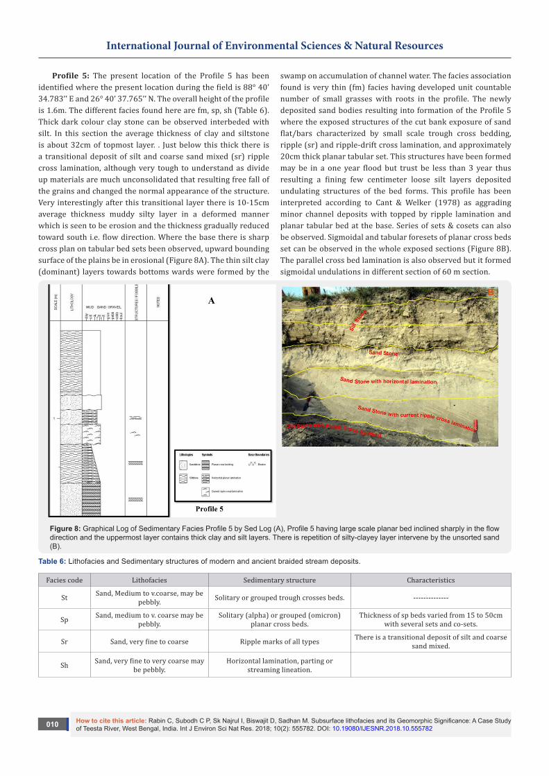
Profile 5: The present location of the Profile 5 has been identified where the present location during the field is 88° 40’ 34.783’’ E and 26° 40’ 37.765’’ N. The overall height of the profile is 1.6m. The different facies found here are fm, sp, sh (Table 6). Thick dark colour clay stone can be observed interbeded with silt. In this section the average thickness of clay and siltstone is about 32cm of topmost layer. . Just below this thick there is a transitional deposit of silt and coarse sand mixed (sr) ripple cross lamination, although very tough to understand as divide up materials are much unconsolidated that resulting free fall of the grains and changed the normal appearance of the structure. Very interestingly after this transitional layer there is 10-15cm average thickness muddy silty layer in a deformed manner which is seen to be erosion and the thickness gradually reduced toward south i.e. flow direction. Where the base there is sharp cross plan on tabular bed sets been observed, upward bounding surface of the plains be in erosional (Figure 8A). The thin silt clay (dominant) layers towards bottoms wards were formed by the
swamp on accumulation of channel water. The facies association found is very thin (fm) facies having developed unit countable number of small grasses with roots in the profile. The newly deposited sand bodies resulting into formation of the Profile 5 where the exposed structures of the cut bank exposure of sand flat/bars characterized by small scale trough cross bedding, ripple (sr) and ripple-drift cross lamination, and approximately 20cm thick planar tabular set. This structures have been formed may be in a one year flood but trust be less than 3 year thus resulting a fining few centimeter loose silt layers deposited undulating structures of the bed forms. This profile has been interpreted according to Cant & Welker (1978) as aggrading minor channel deposits with topped by ripple lamination and planar tabular bed at the base. Series of sets & cosets can also be observed. Sigmoidal and tabular foresets of planar cross beds set can be observed in the whole exposed sections (Figure 8B). The parallel cross bed lamination is also observed but it formed sigmoidal undulations in different section of 60 m section.
Figure 8: Graphical Log of Sedimentary Facies Profile 5 by Sed Log (A), Profile 5 having large scale planar bed inclined sharply in the flow direction and the uppermost layer contains thick clay and silt layers. There is repetition of silty-clayey layer intervene by the unsorted sand (B).
Table 6: Lithofacies and Sedimentary structures of modern and ancient braided stream deposits.
Facies code Lithofacies Sedimentary structure Characteristics
St Sand, Medium to v.coarse, may be pebbly. Solitary or grouped trough crosses beds. --------------
Sp Sand, medium to v. coarse may be pebbly.
Solitary (alpha) or grouped (omicron) planar cross beds.
Thickness of sp beds varied from 15 to 50cm with several sets and co-sets.
Sr Sand, very fine to coarse Ripple marks of all types There is a transitional deposit of silt and coarse sand mixed.
Sh Sand, very fine to very coarse may be pebbly.
Horizontal lamination, parting or streaming lineation.

How to cite this article: Rabin C, Subodh C P, Sk Najrul I, Biswajit D, Sadhan M. Subsurface lithofacies and its Geomorphic Significance: A Case Study of Teesta River, West Bengal, India. Int J Environ Sci Nat Res. 2018; 10(2): 555782. DOI: 10.19080/IJESNR.2018.10.555782011
International Journal of Environmental Sciences & Natural Resources
Sl Sand, fine. Low angle cross beds. -----------
Fl Sand, silt, mud. Fine lamination, very small ripples. -----------
Fm Mud, silt. Massive, desiccation cracks. It has root impressions and trace fossils.
Table 6: Lithofacies and Sedimentary structures of modern and ancient braided stream deposits (modified from Maill,1977, Table 3). Figure 8: Graphical Log of Sedimentary Facies Profile 5 by Sed Log (A), Profile 5 having large scale planar bed inclined
sharply in the flow direction and the uppermost layer contains thick clay and silt layers. There is repetition of silty-clayey layer intervene by the unsorted sand (B).
Figure 9: Graphical Log of Sedimentary Facies Profile 6 by Sed Log (A), Mosaic of the Profile 6 cut bank exposure shows the small scale ripples in the uppermost part and the planar tabular bed with transitional foreset with the bounding surfaces. This section is newly formed sand deposits less than two years in age (B).
Profile 6: The present location of the Profile 6 has been identified where the present location during the field is 88° 45’ 2.431’’ E and 26° 37’ 3.258’’ N. The facies association found is very thin (fm) facies having developed unit countable number of small grasses with roots in the profile (Table 7). The newly deposited sand bodies resulting into formation of the Profile 6
where the exposed structures of the cut bank exposure of sand flat/bars characterized by small scale trough cross bedding, ripple (sr) and ripple-drift cross lamination, and approximately 20cm. thick planar tabular set (Figure 9A, Figure 9B). This structures have been formed may be in a one year flood but trust be less than 3 year thus resulting a fining few centimeter loose

How to cite this article: Rabin C, Subodh C P, Sk Najrul I, Biswajit D, Sadhan M. Subsurface lithofacies and its Geomorphic Significance: A Case Study of Teesta River, West Bengal, India. Int J Environ Sci Nat Res. 2018; 10(2): 555782. DOI: 10.19080/IJESNR.2018.10.555782012
International Journal of Environmental Sciences & Natural Resources
silt layers deposited undulating structures of the bed forms. This profile is exposed sand. It can be interpreted following Cant & Welker (1978) as aggrading minor channel deposits with topped by ripple lamination and planar tabular bed at the base. Series of sets & cosets can also be observed. Sigmoidal and tabular foresets of planar cross beds set can be observed in the whole exposed sections. “The planar cross strata with sigmoidal foresets probably denote local development of humpback dunes or simple cross stratified bars that formed under flow condition transitional to upper phase plane beds” (Chakraborty & Ghosh, 2010). The parallel cross bed lamination is also observed but
it formed sigmoidal undulations in different section of 60m section.
Table 7: Lithofacies and Sedimentary structures of modern and ancient braided stream deposits (modified from Maill, 1977,Table 3). Figure 9: Graphical Log of Sedimentary Facies Profile 6 by Sed Log (A), Mosaic of the Profile 6 cut bank exposure shows the small scale ripples in the uppermost part and the planar tabular bed with transitional foreset with the bounding surfaces. This section is newly formed sand deposits less than two years in age (B).
Table7: Lithofacies and Sedimentary structures of modern and ancient braided stream deposits.
Facies code Lithofacies Sedimentary structure Characteristics
St Sand, Medium to v.coarse, may be pebbly.
Solitary or grouped trough crosses beds.
They are composing of fine sand to silt with occasional medium sand.
Sp Sand, medium to v. coarse may be pebbly.
Solitary (alpha) or grouped (omicron) planar cross beds. Planar cross stratification with impersistent clay.
Sr Sand, very fine to coarse Ripple marks of all types This ripple marks are formed may be in one year flood.
Sh Sand, very fine to very coarse may be pebbly.
Horizontal lamination, parting or streaming lineation. The angle of inclination is less than 10degree.
Sl Sand, fine. Low angle cross beds. -----------
Fl Sand, silt, mud. Fine lamination, very small ripples. -----------
Fm Mud, silt. Massive, desiccation cracks. It has root impressions and trace fossils.
Conclusion
The study area is also focused in specific study reach where field data has been collected to understand the river dynamics as well as sedimentary facies of the fluvial deposits. Total no of six profiles for the analysis of facies has taken for detailed analysis from the cut bank exposer of selected part of the river. Profile 4 is the old deposit of river depositional structure, grain size properties are different from the Profile 3, Profile 6 and Profile 2, Profile 5 in term of the thickness of the bed, grain size properties etc. Profile 1, Profile 4 and Profile 2, Profile 5 has the similarities in term of facies description but far different from the Profile 3 and Profile 6. Here time has recorded and it is to be absent that the scale of deposit in term of time scale where the depositional structure of the Profile 1 and Profile 4 in different from the depositional structure of the Profile 2, Profile 5 and Profile 3, Profile 6. Top profile are large in term of depositional structure and the thickness of the beds are more than the Profile 2, Profile 5 and Profile 3, Profile 6while the most of the collected samples of grain size of the river Teesta in dominantly medium to coarser sand, gravel only be found in the Profile 1, Profile 4 on the old fluvial deposits as excepted high energy environment was prevailed in the past as recent years construction of engineering structure resulting decreasing river water flow (Ghosh, 2014). The present work is concentrated to establish the facies characteristics by changing vertical facies log by identifying structure and thickness deposits. This work will build the path for the future research on fluvial facies of Teesta as this is the basic study of the characterization of facies in relation to the river dynamics.
References1. Cant DJ, Walker RG (1978) Fluvial processes and facies sequences in
the sandy braided South Saskatchewan River, Canada Sedimentology 25(5): 625-648.
2. Kale VS, Achyuthan H, Jaiswal M, Sengupta S (2010) Palaeoflood records from upper Kaveri River, southern India: evidence for discrete floods during Holocene. Geochronometria 37(1): 49-55.
3. Rajaguru SN, Ganjoo RK, Misra VN (1994) A fresh look at the Quaternary litho and bio-stratigraphy of a part of the central Narmada valley, Narsinghpur district, Madhya Pradesh. India: geomorphological diversity. Rawat Publication Jaipur, India 435-452.
4. Rajaguru SN, Kale VS, Badam GL (1993) Quaternary fluvial systems in Upland Maharashtra. Current Science 817-822.
5. Nichols G (1999) Sedimentology and Stratigraphy. Blackwell Oxford: 355.
6. Juyal N, Raj R, Maurya DM, Chamyal LS, Singhvi AK (2000) Chronology of Late Pleistocene environmental changes in the lower Mahi basin, western India. Journal of Quaternary Science 15(5): 501-508.
7. Kale VS, Gupta A, Singhvi AK (2003) 13 Late Pleistocene Holocene Palaeohydrology of Monsoon Asia. Palaeohydrology: understanding global change pp.213.
8. Thomas PJ, Juyal N, Kale VS, Singhvi AK (2007) Luminescence chronology of late Holocene extreme hydrological events in the upper Penner River basin, South India. Journal of Quaternary Science, 22(8): 747-753.
9. Rajganapathi VC, Jitheshkumar N, Sundararajan M, Bhat KH, Velusamy S (2013) Grain size analysis and characterization of sedimentary environment along Thiruchendur coast, Tamilnadu, India. Arabian Journal of Geosciences 6(12): 4717-4728.
10. Bristow CS (1993) Sedimentary structures exposed in bar tops in the Brahmaputra River, Bangladesh. Geological Society. London Special Publications 75(1): 277-289.

How to cite this article: Rabin C, Subodh C P, Sk Najrul I, Biswajit D, Sadhan M. Subsurface lithofacies and its Geomorphic Significance: A Case Study of Teesta River, West Bengal, India. Int J Environ Sci Nat Res. 2018; 10(2): 555782. DOI: 10.19080/IJESNR.2018.10.555782013
International Journal of Environmental Sciences & Natural Resources
11. Chamyal LS, Khadkikar AS, Malik JN, Maurya DM (1997) Sedimentology of the Narmada alluvial fan, western India. Sedimentary Geology 107(3-4): 263-279.
12. Joshi VU, Kale VS (1997) Colluvial deposits in northwest Deccan, India: their significance in the interpretation of late Quaternary history. Journal of Quaternary Science 12(5): 391-403.
13. Alam M, Alam MM, Curray JR, Chowdhury MLR, Gani MR (2003) An overview of the sedimentary geology of the Bengal Basin in relation to the regional tectonic framework and basin fill history. Sedimentary Geology 155(3): 179-208.
14. Goodbred SL, Kuehl SA, Steckler MS, Sarker MH (2003) Controls on facies distribution and stratigraphic preservation in the Ganges-Brahmaputra delta sequence. Sedimentary Geology 155(3): 301-316.
15. Miall AD (1997) The Geology of Stratigraphic Sequences. Springer, Berlin 433
16. Sinha R, Tandon SK, Gibling MR, Bhattacharjee PS, Disrupt AS (2005) Late Quaternary geology and alluvial stratigraphy of the Ganga basin. Himalayan Geology, 26(1): 223-240.
17. Tewari RC, Hota RN, Maejima W (2012) Fluvial architecture of Early Permian Barakar rocks of Korba Gondwana basin, eastern-central India. Journal of Asian Earth Sciences 52: 43-52.
18. Ghosh S, Guchhait SK (2014) Palaeoenvironmental significance of fluvial facies and archives of Late Quaternary deposits in the floodplain of Damodar River, Arab J Geosci, India 7: 4145-4161.
19. Sinha R, Friend PF (1994) River systems and their sediment flux, Indo Gangetic plains, northern Bihar, India: Sedimentology 41: 825-845.
20. Chakraborty T, Kar P, Ghosh P, Basu S (2010) Kosi Megafan: Historical records, geomorphology and the recent avulsion of the Kosi River. Quaternary International 143-160.
21. Cheetham GH (1976) Palaeohydrological investigations of river terrace gravels. Geo-archaeology: earth science and the past. Duckworth, London, UK, pp. 335-344.
22. Sen PK (1985) The genesis of floods in the lower Damodar catchment. The concepts and methods in geography. The University of Burdwan Burdwan, India, p. 71-85.
23. Brakenridge GR (1988) River flood regime and floodplain stratigraphy. Flood Geomorphology. John Wiley & Sons New York, UK, pp. 139-156.
24. Baker VR, Kochel RC, Patton PC (1988) Flood geomorphology. In Flood geomorphology. Wiley-Interscience.
25. Deo S, Mishra S, Rajaguru SN (2004) Palaeoclimatic Studies at the Deccan College (1940-2005): a Geoarchaeological Approach. Bulletin of the Deccan College Research Institute 64: 209-228.
26. Ghosh S, Mistri B (2012) Investigating the causes of floods in Damodar River of India: A geographical perspective. Indian Journal of Geomorphology 17(1): 37-49.
27. Miall AD (1994) Sequence stratigraphy and chronostratigraphy: problems of definition and precision in correlation, and their implications for global eustasy. Geoscience Canada 21: 1-26.
28. Mukhopadhyay SC (1982) The Tista Basin: A Study in Fluvial Geomorphology KP Bagchi and Company, Calcutta, India pp. 308.
29. Miall AD (1985) Architectural-element analysis: a new method of facies analysis applied to fluvial deposits. Earth Science Reviews 22(4): 261-308.
30. Einsele G (1992) Sedimentary Basins, Berlin, Heidelberg Newyork. Springer Verlag 628.
Your next submission with Juniper Publishers will reach you the below assets
• Quality Editorial service• Swift Peer Review• Reprints availability• E-prints Service• Manuscript Podcast for convenient understanding• Global attainment for your research• Manuscript accessibility in different formats
( Pdf, E-pub, Full Text, Audio) • Unceasing customer service
Track the below URL for one-step submission https://juniperpublishers.com/online-submission.php
This work is licensed under CreativeCommons Attribution 4.0 LicenseDOI: 10.19080/IJESNR.2018.10.555782