sudan now and before
TRANSCRIPT
2015
DN-El-2013-027-1
Ghofran Alnabilsy
[SUDAN NOW AND BEFORE]
Research Entitled By :
1
Done By:
Ghofran Mohammad Alnabilsy
Index No. :
Dn-El-2013-027-1
Electronic Engineering
Control Department
Batch (7)
Sudanese Studies
Dr. Zienab Alzuber
University of Medical Science and Technology
Khartoum, Sudan
2014-2015
2
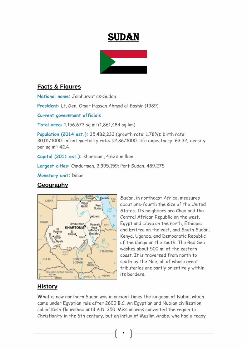
Sudan
Facts & Figures
National name: Jamhuryat as-Sudan
President: Lt. Gen. Omar Hassan Ahmad al-Bashir (1989)
Current government officials
Total area: 1,156,673 sq mi (1,861,484 sq km)
Population (2014 est.): 35,482,233 (growth rate: 1.78%); birth rate:
30.01/1000; infant mortality rate: 52.86/1000; life expectancy: 63.32; density
per sq mi: 42.4
Capital (2011 est.): Khartoum, 4.632 million
Largest cities: Omdurman, 2,395,159; Port Sudan, 489,275
Monetary unit: Dinar
Geography
Sudan, in northeast Africa, measures
about one-fourth the size of the United
States. Its neighbors are Chad and the
Central African Republic on the west,
Egypt and Libya on the north, Ethiopia
and Eritrea on the east, and South Sudan,
Kenya, Uganda, and Democratic Republic
of the Congo on the south. The Red Sea
washes about 500 mi of the eastern
coast. It is traversed from north to
south by the Nile, all of whose great
tributaries are partly or entirely within
its borders.
History
What is now northern Sudan was in ancient times the kingdom of Nubia, which
came under Egyptian rule after 2600 B.C. An Egyptian and Nubian civilization
called Kush flourished until A.D. 350. Missionaries converted the region to
Christianity in the 6th century, but an influx of Muslim Arabs, who had already

3
conquered Egypt, eventually controlled the area and replaced Christianity with
Islam. During the 1500s a people called the Funj conquered much of Sudan, and
several other black African groups settled in the south, including the Dinka,
Shilluk, Nuer, and Azande. Egyptians again conquered Sudan in 1874, and after
Britain occupied Egypt in 1882, it took over Sudan in 1898, ruling the country in
conjunction with Egypt. It was known as the Anglo-Egyptian Sudan between 1898
and 1955.
Nubia
Nubia is a region along the Nile river, which is
located in northern Sudan and southern Egypt.
There were a number of large Nubian
kingdoms throughout the Postclassical Era, the
last of which collapsed in 1504, when Nubia
became divided between Egypt and the Sennar
sultanate resulting in the Arabization of much
of the Nubian population. Nubia was again
united within Ottoman Egypt in the 19th
century, and within Anglo-Egyptian Sudan from
1899 to 1956.
The name Nubia is derived from that of the
Noba people, nomads who settled the area in
the 4th century, with the collapse of the
kingdom of Meroë. The Noba spoke a Nilo-
Saharan language, ancestral to Old Nubian. Old
Nubian was mostly used in religious texts
dating from the 8th and 15th centuries AD.
Before the 4th century, and throughout
classical antiquity, Nubia was known as Kush,
or, in Classical Greek usage, included under the
name Ethiopia (Aithiopia).
Historically, the people of Nubia spoke at least two varieties of the Nubian
language group, a subfamily which includes Nobiin (the descendant of Old
Nubian), Kenuzi-Dongola, Midob and several related varieties in the northern
part of the Nuba Mountains in South Kordofan. Until at least 1970, the Birgid
language was spoken north of Nyala in Darfur but is now extinct.
Nubia was divided into two major regions: Upper and Lower Nubia, so called
because of their location in the Nile river valley, the 'lower' being further
downstream than the 'upper'. Lower Nubia lay between the First and Second
Cataracts of the Nile river, spreading in modern southern Egypt and northern

4
Sudan, while Upper Nubia extended between the Second and Sixth Cataracts, in
modern central Sudan.
Kingdoms of Nubia:
1- Kingdom of Kerma
From the pre-Kerma culture, the first kingdom
to unify much of the region arose. The Kingdom
of Kerma, named for its presumed capital at
Kerma, was one of the earliest urban centers in
the Nile region. By 1750 BC, the kings of Kerma
were powerful enough to organize the labor for
monumental walls and structures of mud brick.
They also had rich tombs with possessions for
the afterlife and large human sacrifices.
George Reisner excavated sites at Kerma and
found large tombs and a palace-like structures.
The structures, named (Deffufa), alluded to
the early stability in the region. At one point,
Kerma came very close to conquering Egypt.
Egypt suffered a serious defeat at the hands
of the Kushites.
According to Davies, head of the joint British Museum and Egyptian
archaeological team, the attack was so devastating that if the Kerma forces
chose to stay and occupy Egypt, they might have eliminated it for good and
brought the nation to extinction. When Egyptian power revived under the
New Kingdom (c. 1532–1070 BC) they began to expand further southwards.
The Egyptians destroyed Kerma's kingdom and capitol and expanded the
Egyptian empire to the Fourth Cataract.
By the end of the reign of Thutmose I (1520 BC), all of northern Nubia had
been annexed. The Egyptians built a new administrative center at Napata,
and used the area to produce gold. The Nubian gold production made Egypt a
prime source of the precious metal in the Middle East. The primitive working
conditions for the slaves are recorded by Diodorus Siculus who saw some of
the mines at a later time. One of the oldest maps known is of a gold mine in
Nubia, the Turin Papyrus Map dating to about 1160 BC.
5
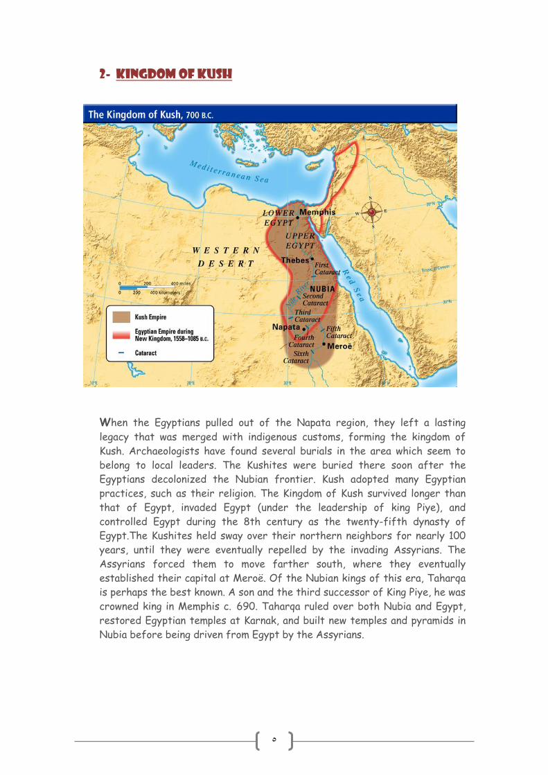
2- Kingdom of Kush
When the Egyptians pulled out of the Napata region, they left a lasting
legacy that was merged with indigenous customs, forming the kingdom of
Kush. Archaeologists have found several burials in the area which seem to
belong to local leaders. The Kushites were buried there soon after the
Egyptians decolonized the Nubian frontier. Kush adopted many Egyptian
practices, such as their religion. The Kingdom of Kush survived longer than
that of Egypt, invaded Egypt (under the leadership of king Piye), and
controlled Egypt during the 8th century as the twenty-fifth dynasty of
Egypt.The Kushites held sway over their northern neighbors for nearly 100
years, until they were eventually repelled by the invading Assyrians. The
Assyrians forced them to move farther south, where they eventually
established their capital at Meroë. Of the Nubian kings of this era, Taharqa
is perhaps the best known. A son and the third successor of King Piye, he was
crowned king in Memphis c. 690. Taharqa ruled over both Nubia and Egypt,
restored Egyptian temples at Karnak, and built new temples and pyramids in
Nubia before being driven from Egypt by the Assyrians.

6
3-Kingdom of Meroë:
Aerial view at Nubian pyramids, Meroe.
Meroë (800 BC – c. AD 350) in
southern Nubia lay on the east bank
of the Nile about 6 km north-east of
the Kabushiya station near Shendi,
Sudan, ca. 200 km north-east of
Khartoum. The people there
preserved many ancient Egyptian
customs but were unique in many
respects. They developed their own
form of writing, first utilizing Egyptian hieroglyphs, and later using an alphabetic
script with 23 signs. Many pyramids were built in Meroë during this period and
the kingdom consisted of an impressive standing military force. Strabo also
describes a clash with the Romans in which the Romans defeated Nubians.
According to Strabo, following the Kushite advance, Petronius (a Prefect of
Egypt at the time) prepared a large army and marched south. The Roman forces
clashed with the Kushite armies near Thebes and forced them to retreat to
Pselchis (Maharraqa) in Kushite lands. Petronius, then, sent deputies to the
Kushites in an attempt to reach a peace agreement and make certain demands.
Quoting Strabo, the Kushites "desired three days for consideration" in order to
make a final decision. However, after the three days, Kush did not respond and
Petronius advanced with his armies and took the Kushite city of Premnis (modern
Karanog) south of Maharraqa. From there, he advanced all the way south to
Napata, the second Capital in Kush after Meroe. Petronius attacked and sacked
Napata, causing the son of the Kushite Queen to flee. Strabo describes the
defeat of the Kushites at Napata, stating that "He (Petronius) made prisoners
of the inhabitants"."
During this time, the different parts of the region divided into smaller groups
with individual leaders, or generals, each commanding small armies of
mercenaries. They fought for control of what is now Nubia and its surrounding
territories, leaving the entire region weak and vulnerable to attack. Meroë would
eventually meet defeat by a new rising kingdom to their south, Aksum, under
King Ezana.
The classification of the Meroitic language is uncertain; it was long assumed to
have been of the Afro-Asiatic group, but is now considered to have likely been
an Eastern Sudanic language.
At some point during the 4th century, the region was conquered by the Noba
people, from which the name Nubia may derive (another possibility is that it

7
comes from Nub, the Egyptian word for gold). From then on, the Romans
referred to the area as the Nobatae.
Christian Nubia
Around AD 350, the area was invaded by
the Kingdom of Aksum and the kingdom
collapsed. Eventually, three smaller
kingdoms replaced it: northernmost was
Nobatia between the first and second
cataract of the Nile River, with its capital
at Pachoras (modern-day Faras); in the
middle was Makuria, with its capital at Old
Dongola; and southernmost was Alodia,
with its capital at Soba (near Khartoum).
King Silky of Nobatia crushed the
Blemmyes, and recorded his victory in a
Greek inscription carved in the wall of the
temple of Talmis (modern Kalabsha)
around AD 500.
While bishop Athanasius of Alexandria consecrated one Marcus as bishop of
Philae before his death in 373, showing that Christianity had penetrated the
region by the 4th century, John of Ephesus records that a Monophysite priest
named Julian converted the king and his nobles of Nobatia around 545. John of
Ephesus also writes that the kingdom of Alodia was converted around 569.
However, John of Biclarum records that the kingdom of Makuria was converted
to Catholicism the same year, suggesting that John of Ephesus might be
mistaken. Further doubt is cast on John's testimony by an entry in the chronicle
of the Greek Orthodox Patriarch of Alexandria Eutychius, which states that in
719 the church of Nubia transferred its allegiance from the Greek to the Coptic
Orthodox Church.
By the 7th century, Makuria expanded becoming the dominant power in the
region. It was strong enough to halt the southern expansion of Islam after the
Arabs had taken Egypt. After several failed invasions the new rulers agreed to a
treaty with Dongola allowing for peaceful coexistence and trade. This treaty
held for six hundred years. Over time the influx of Arab traders introduced
Islam to Nubia and it gradually supplanted Christianity. While there are records
of a bishop at Qasr Ibrim in 1372, his see had come to include that located at
Faras. It is also clear that the cathedral of Dongola had been converted to a
mosque in 1317.

8
The influx of Arabs and Nubians to Egypt and Sudan had contributed to the
suppression of the Nubian identity following the collapse of the last Nubian
kingdom around 1504. A major part of the modern Nubian population became
totally Arabized and some claimed to be Arabs (Jaa'leen – the majority of
Northern Sudanese – and some Donglawes in Sudan). A vast majority of the
Nubian population is currently Muslim, and the Arabic language is their main
medium of communication in addition to their indigenous old Nubian language.
The unique characteristic of Nubian is shown in their culture (dress, dances,
traditions, and music).
Islamic Nubia
In the 14th century, the Dongolan government collapsed and the region became
divided and dominated by Arabs. The next centuries would see several Arab
invasions of the region, as well as the establishment of a number of smaller
kingdoms. Northern Nubia was brought under Egyptian control while the south
came under the control of the Kingdom of Sennar in the 16th century. The
entire region would come under Egyptian control during the rule of Muhammad
Ali in the early 19th century, and later became a joint Anglo-Egyptian
condominium.

9
The New Sudan
Below is a list of the 18 states of Sudan, organized by their original provinces
during the period of Anglo-Egyptian Sudan. Arabic language versions are, as
appropriate, in parentheses. States that were not provinces before 1994 are
marked with (*). Transliterations from Arabic to English may vary; in particular,
the article "al" is sometimes transliterated as "el". Numbers correspond to
those of the map at right. Prior to 9 July 2011, the Republic of Sudan was
composed of 25 states. The ten southern states now form part of the
independent country of South Sudan. Two additional states were created in
2012 within the Darfur region, and one in 2013 in Kurdufan, bringing the total to
18.
10
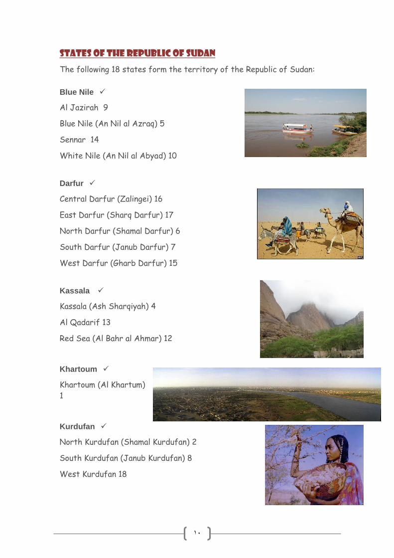
States of the Republic of Sudan
The following 18 states form the territory of the Republic of Sudan:
Blue Nile
Al Jazirah 9
Blue Nile (An Nil al Azraq) 5
Sennar 14
White Nile (An Nil al Abyad) 10
Darfur
Central Darfur (Zalingei) 16
East Darfur (Sharq Darfur) 17
North Darfur (Shamal Darfur) 6
South Darfur (Janub Darfur) 7
West Darfur (Gharb Darfur) 15
Kassala
Kassala (Ash Sharqiyah) 4
Al Qadarif 13
Red Sea (Al Bahr al Ahmar) 12
Khartoum
Khartoum (Al Khartum)
1
Kurdufan
North Kurdufan (Shamal Kurdufan) 2
South Kurdufan (Janub Kurdufan) 8
West Kurdufan 18

11
Northern
Northern (Ash Shamaliyah) 3
River Nile (Nahr an Nil) 11
12
World > Countries > Sudan
Adam, William Y. (1977): Nubia: Corridor to Africa, London.
"Black Pharaohs", National Geographic, Feb 2008
Bulliet et al. (2001): Nubia, The Earth and Its Peoples, pp. 70–71,
Houghton Mifflin Company, Boston.
Emberling, Geoff (2011): Nubia: Ancient Kingdoms of Africa. New
York: Institute for the Study of the Ancient World.
Fisher, Marjorie, et al. (2012): Ancient Nubia: African Kingdoms on
the Nile. The American University in Cairo Press.
Hassan, Yusuf Fadl (1973): The Arabs and the Sudan, Khartoum.
Jennings, Anne (1995) The Nubians of West Aswan: Village
Women in the Midst of Change, Lynne Reinner Publishers.
Thelwall, Robin (1978): "Lexicostatistical relations between
Nubian, Daju and Dinka", Études nubiennes: colloque de
Chantilly, 2–6 juillet 1975, 265–286.
Thelwall, Robin (1982) 'Linguistic Aspects of Greater Nubian
History', in Ehret, C. & Posnansky, M. (eds.) The Archeological
and Linguistic Reconstruction of African History.Berkeley/Los
Angeles, 39–56.
Török, László (1997): The Kingdom of Kush: Handbook of the
Napatan-Meroitic Civilization. Brill Academic Publishers.
Valbelle, Dominique, and Bonnet, Charles (2006): The Nubian
Pharaohs. New York: The American University in Cairo Press.
Western Kordofan State
Sudan shuffles governors of Kordofan states including ICC
suspect
http://allafrica.com/stories/201201110764.html

13
Title Page No. Sudan
(Introduction)
2
Nubia 3
Kingdom of Kerma 4
Kingdom of Kush 5
Kingdom of Meroe 6
Christian Nubia 7
Islamic Nubia 8
The New Sudan 9
States of The
Republic of Sudan
10
References 12