suitable locations for new gas stations in mankato,...
TRANSCRIPT

Suitable Locations for New Gas Stations In Mankato, MNBENJAMIN ALBERT

Data
Collected data from MNDOT(Traffic data), TIGER(Road network), MNGEO (Elevation data), MN Geospatial Commons (Land Use data)
Aerial analysis to find the current gas stations in Mankato, used google docs to geo code the addresses into a layer.
Clipped all data to only include the urban area around Mankato.
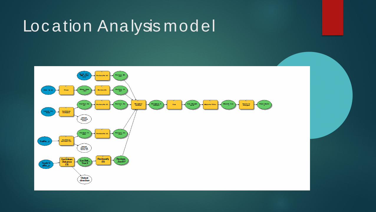
Location Analysis model

Methodology
Reclassify data to favor ideal conditions for a new gas station. Use reclassified data to find optimal locations for Gas stations based
on proximity to major roads and distance from competition.
Use weighted overlay to assign different values to different conditions.
Find the best spots to build

Traffic Data
This was actually done outside the model then I ran a Euclidean distance on just the busiest 1/3 of ofstreets

Heavy Truck TrafficDid the same thing with the trucks and only took the top 1/3rd again to be used for the Euclidean distance

Land use Data
You cant just build a gas station anywhere you want.I cut out the landuses that were restricted to new buildings, like open water and already built-up areas.

Competitor gas stations

Terrain Data
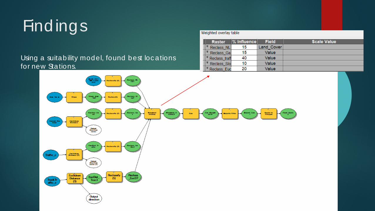
Findings
Using a suitability model, found best locations for new Stations.

Findings

FindingsUsing the Con tool I extracted only the two highest classes of suitability (left) and the highest bracket (right)

Findings
After using the Con tool to pull out only the highest ranked areas I converted them into vector data for better visualization and analysis.

Findings
Using only the highest ranked bracket I narrowed it down further by looking at the base map and hand deleting areas that are not suitable due to old data.

Findings
Remember this map from earlier? All 4 of the most ideal locations are further than three quarters of a mile from any competition, on stable ground (no slope), close to main roads, and sitting on Land that is buildable.


COGOin’ Colleagues Enabling land records staff with the
Parcel Drafter Widget
Nick Flatgard
Steele County
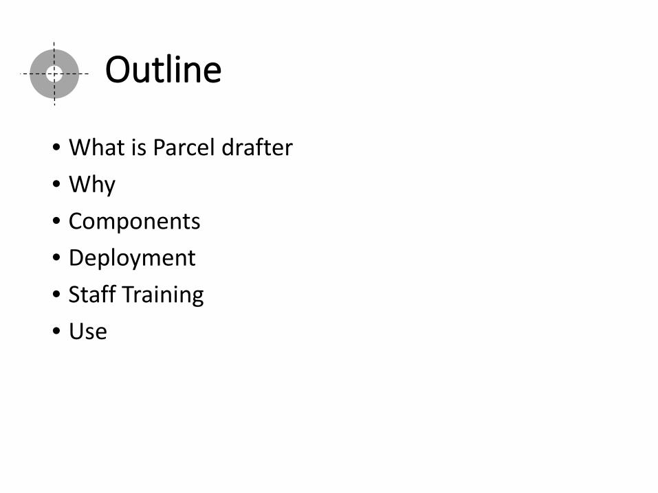
Outline
• What is Parcel drafter• Why• Components• Deployment• Staff Training• Use

What
• ESRI Widget for Web AppBuilder (AGO & DE)

What does this describe? Tangential Curve?What is this exception?
Can you draw out this legal for me?Rods, Links, chains?
I don’t do curves!
Point of Beginning
N90° E 150.00’90°
90°
Tangent Curve
Non-Tangent Curve
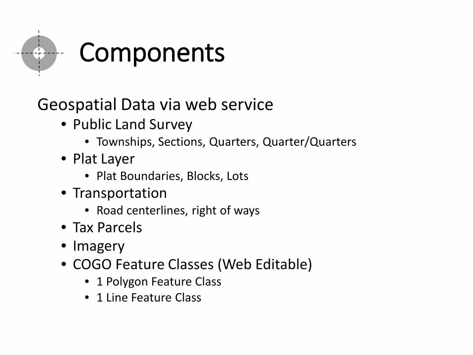
Components
Geospatial Data via web service• Public Land Survey
• Townships, Sections, Quarters, Quarter/Quarters• Plat Layer
• Plat Boundaries, Blocks, Lots• Transportation
• Road centerlines, right of ways• Tax Parcels• Imagery• COGO Feature Classes (Web Editable)
• 1 Polygon Feature Class• 1 Line Feature Class

Components cont.
COGO Feature Classes• Self-hosted or AGO hosted feature service• Line Fields
• Relate Global ID, Bearing, Distance, Radius, ArcLength, ChordLength
• Polygon Fields• Rotation, Scale, Global ID, Name, Type, Misclose
• Relationship Class• Global ID• Relate Global ID
Components cont.
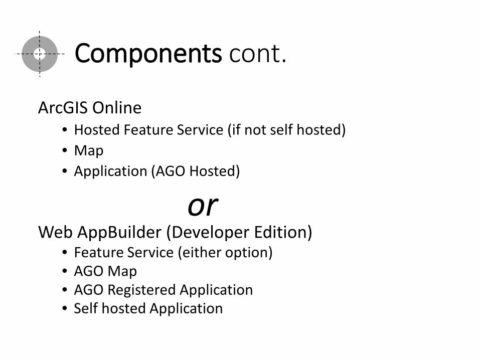
ArcGIS Online• Hosted Feature Service (if not self hosted)• Map• Application (AGO Hosted)
orWeb AppBuilder (Developer Edition)
• Feature Service (either option)• AGO Map• AGO Registered Application • Self hosted Application

Deployment
Focused Application

Search
Deployment cont.

Print Plus
Deployment cont.
Print service
Data Frame
Cache Scales
config.json

Parcel Drafter
Deployment cont.

• Single office testing June 2017• Division release August 2017• Staff Training September 2017
Staff Training


def Why ():
• Needed Update
• Repetitive
• Cost effective
• Learn python

def Methods ():
Parcel Labeling• Field Work
• Remove unneeded • Add fields for labels
• Dissolve Parcels• Same sec/twp/rg & ownership
• Calculate acreage• Assign labels (data access update cursor)
• Determined by parcel area• string.split() (short & long labels)• single letter

def Methods (cont):
Owner Index• Import reportlab
• PLATYPUS – Page Layout and Typography using Scripts
Page Template
Fram
e 1
Fram
e 2
Fram
e 3
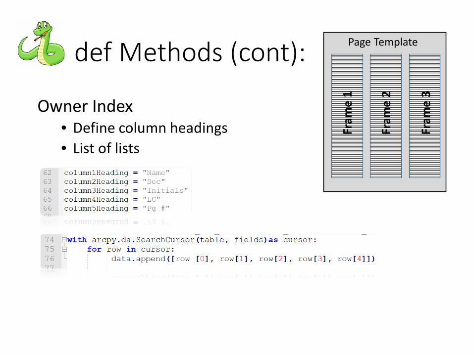
def Methods (cont):
Owner Index• Define column headings• List of lists
Page Template
Fram
e 1
Fram
e 2
Fram
e 3

def Methods(cont):
Owner Index• Set reportlab table style• Append flowables• Build PDF

def Methods (cont):
arcpy.mapping• Replace layers in existing mxd’s• Produce maps
• Township• Parcel
• Compile• Non map pages• Map pages• Owner index
• Build document

def Cover(GIMP):

StormwaterInspections with
Survey123

Past Inspections
Paper Inspection Forms – 10 forms. Storage – File and/or Scanned
Not easily mapped.
Difficult to search or query

Stormwater Inspection Goals
Provide a Mobile Solution for Stormwater Inspections Needs:
To be Accessible in various platforms.
Easily symbolized and mapped.
Ability to query data.
Provide Reports.

Collector for ArcGIS
Sufficient Option
Edit our Feature Services (related tables)
The inspection tables can be mapped easily through spatial views.
Easily searchable.
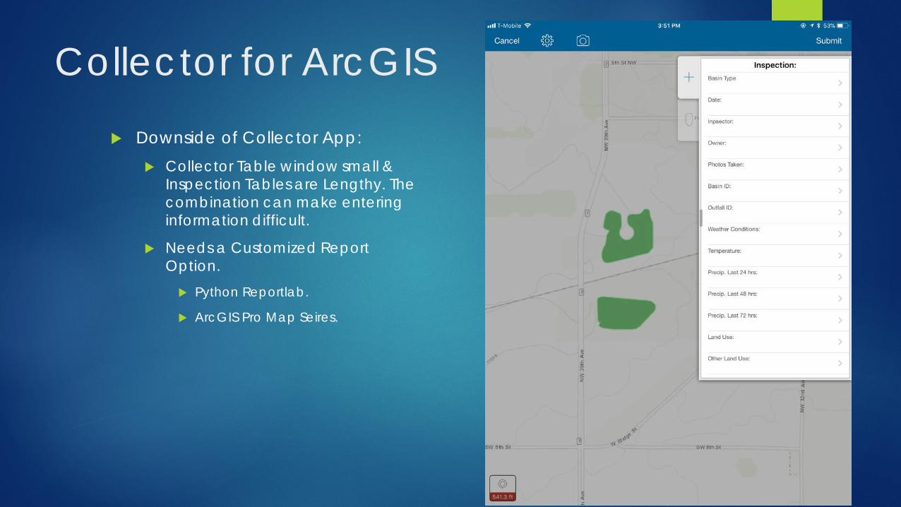
Collector for ArcGIS
Downside of Collector App: Collector Table window small &
Inspection Tables are Lengthy. The combination can make entering information difficult.
Needs a Customized Report Option. Python Reportlab.
ArcGIS Pro Map Seires.
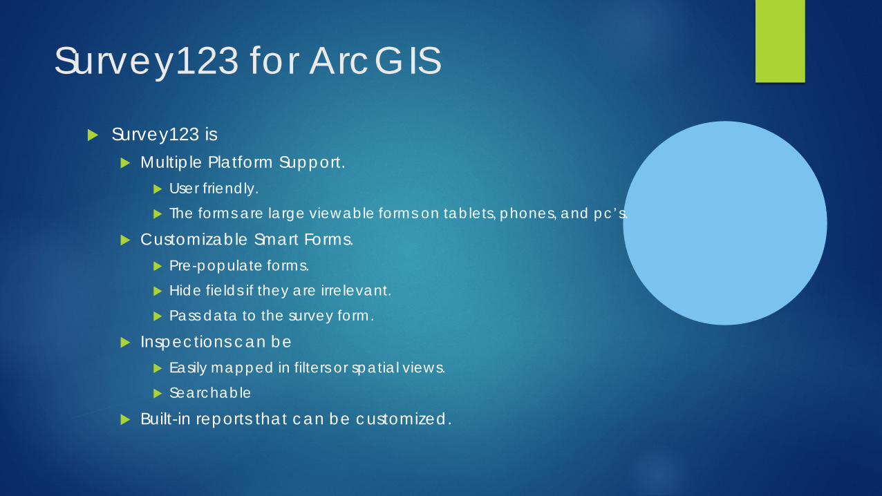
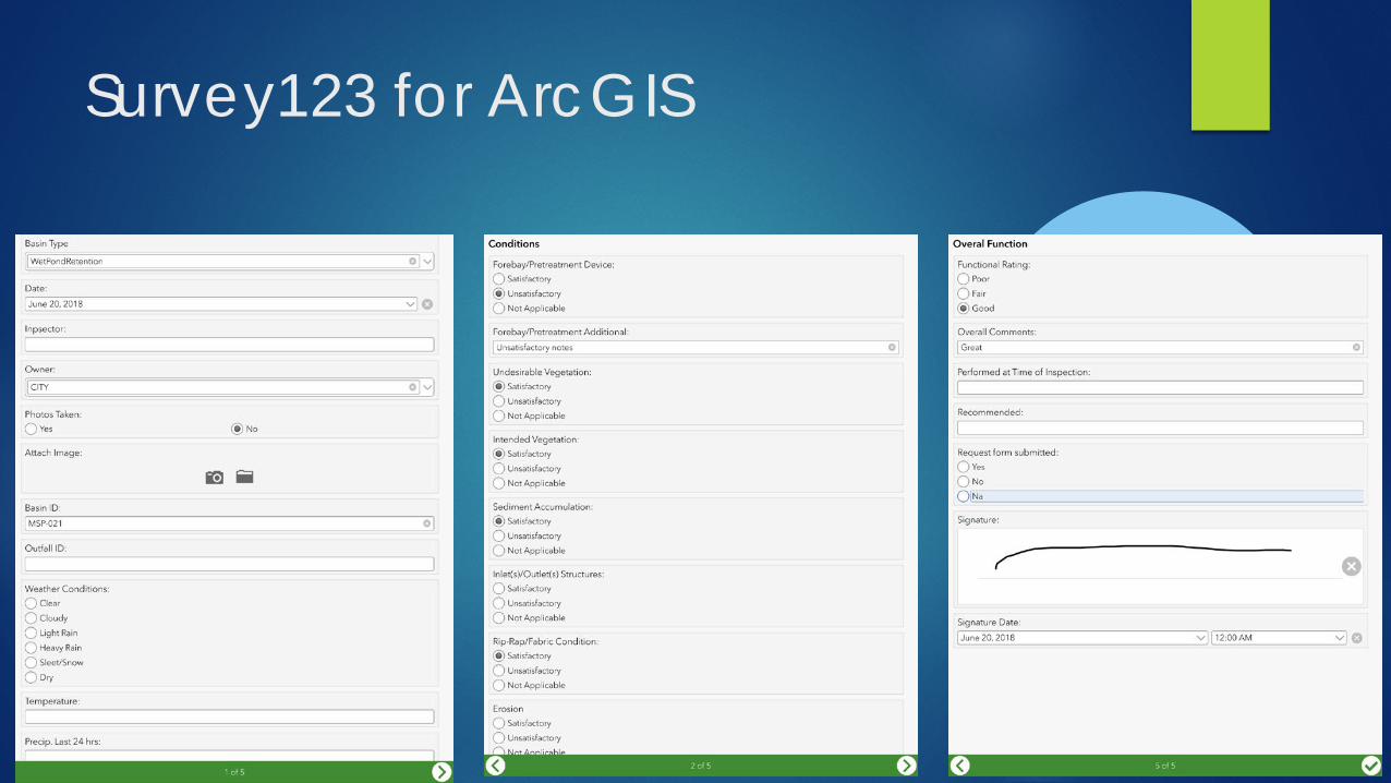
Survey123 for ArcGIS
Survey123 is Multiple Platform Support.
User friendly. The forms are large viewable forms on tablets, phones, and pc’s.
Customizable Smart Forms. Pre-populate forms. Hide fields if they are irrelevant. Pass data to the survey form.
Inspections can be Easily mapped in filters or spatial views. Searchable
Built-in reports that can be customized.
Survey123 for ArcGIS

Survey123 for ArcGIS
Hosted Feature Layer in ArcGIS Online We have multiple Surveys Forms 10 Stormwater
Point for each survey record. Stacked Points Points can have Inaccurate
Locations
Difficult to quickly view the latest inspections / current status.
Began Using Survey123 before the ability to use ArcServer Feature Services.

Survey123 for ArcGIS
Convert to Our Feature Services
Relationship Class (Global Id’s)
SQL Spatial Views Map Latest Inspections
Or Specific Categories
In the process of converting Existing Survey123 hosted layers to ArcGIS Server Feature Services.

Survey123 with non-federated ArcGIS Server services
Requirements: ArcGIS Server 10.3.1 or later
Must have Global ID’s
Feature service cannot be versioned
Service must be secured
Service registered in AGO with credentials saved.

Survey123 Form Creation Customize Survey form in
an XLSForm spreadsheet Survey Tab Choices Tab
Domains
Settings Tab Title, Id, Style Service URL
Types Tab Describes Rules,
Formatting, Field Types, Functions
XLSForm Syntax http://xlsform.org
Survey123 Connect

Survey123 Form Creation

Survey123 for ArcGIS
Demo AGO Web App Link

Updates from St. Paul
Mike Dolbow | GIS Supervisor, MnGeoSE MN GIS User Group Meeting, June 21, 2018

Agenda
Topic
Great Outdoors Application
Demo
Tech Stack
Data Maintenance
LUCA
NG911
Standards
Geospatial Commons
7/17/2018 2


Demo…
7/17/2018 4

Demo…
7/17/2018 5

Demo…
7/17/2018 6
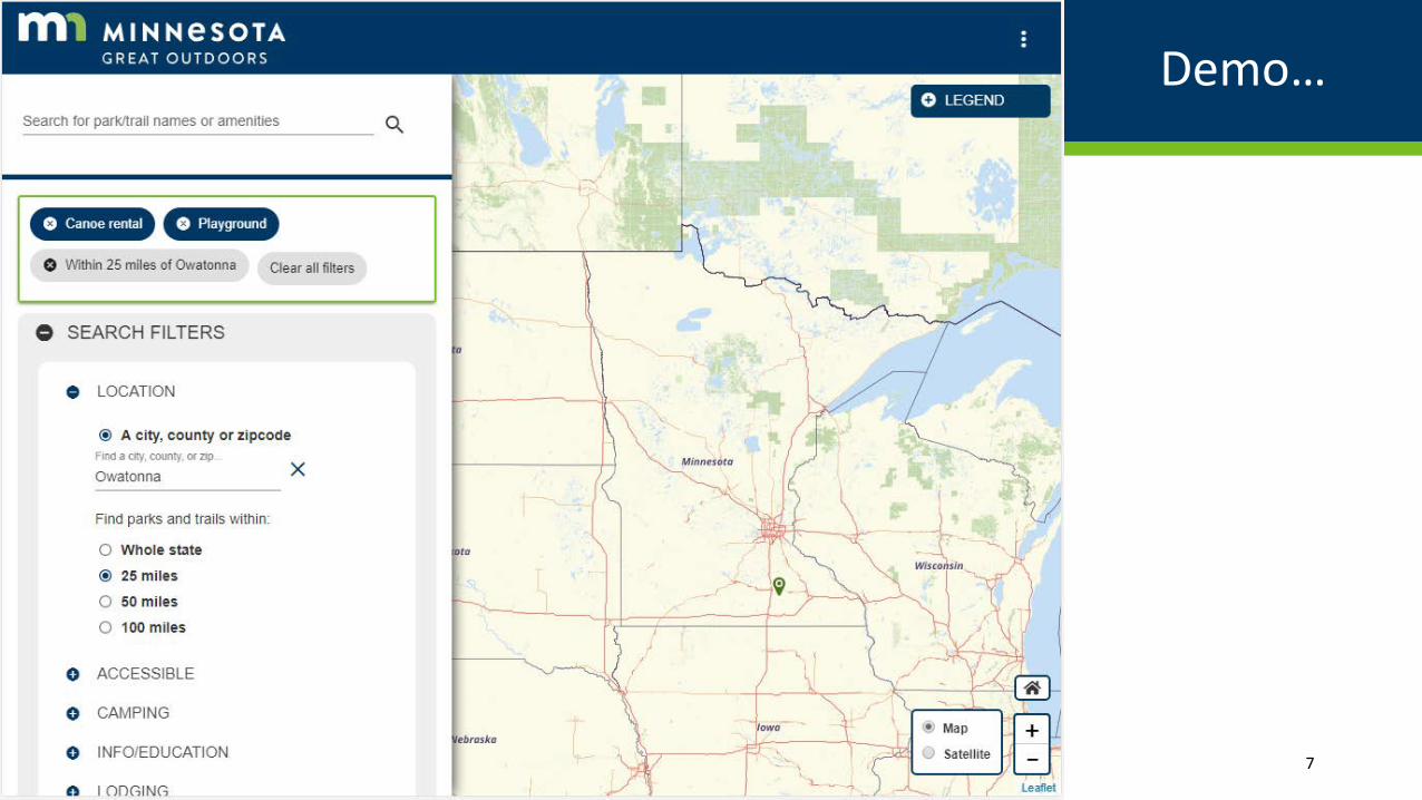
Demo…
7/17/2018 7
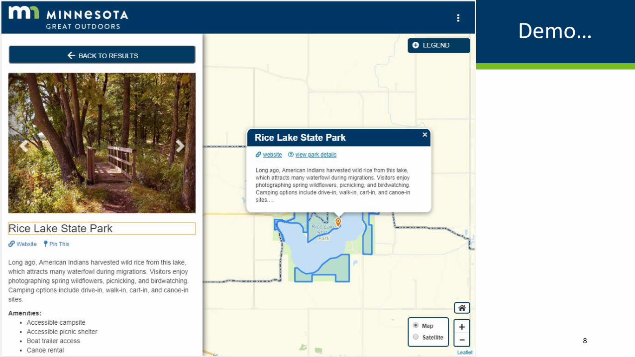
Demo…
7/17/2018 8

Great Outdoors: Tech Stack
• Apache Solr (Search)
• Material Design (CSS, styling)
• Angular (JS Framework)
• Leaflet (Mapping Library)
• Gitlab (code versioning and issue management)
• OSM basemap (self-hosted & styled)
• ArcGIS Server (poly, line overlays)
7/17/2018 9

Great Outdoors: Data Maintenance
• Each “steward” (DNR, Met Council, Greater Minnesota Regional Parks & Trails Commission) has a secure data maintenance site through AGOL
• Can add, remove, modify, add photos, etc
• Everything goes through extract, transfer, load (ETL) overnight and shows up in the app the next day
• Questions?
7/17/2018 10

Local Update of Census Addresses (LUCA)
• MnGeo submitting for counties that declined or not registered
• Working with cities within counties that might not be covered
• Will share knowledge as best as we can (can’t share the Census data)
• Brent Lund (PM), plus two Student Workers
7/17/2018 11

LUCA stats
7/17/2018 12
County Add Delete Correct Not in Juris. Non-Res.Comments
Aitkin 3 51 166 0 0OngoingBig Stone 13 21 42 0 2Chippewa 15 17 7 0 0Clearwater 10 60 29 0 4Cottonwood 14 14 4 0 0Faribault 0 0 0 0 0Grant 0 0 0 0 0Houston 0 0 0 0 0Jackson 0 0 0 0 0Kanabec 0 0 0 0 0Kittson 0 0 0 0 0Lac qui Parle 4 9 67 0 4Le Sueur 69 46 235 0 1Lincoln 15 1 32 0 1Mahnomen 0 0 0 0 0On hold due to incomplete parcel dataMarshall 17 11 182 0 0McLeod 11 4 3 0 0Pennington 0 1 4 0 0Red Lake 11 7 34 0 0OngoingWadena 0 0 0 0 0Norman 0 0 0 0 0subset of county will be reviewedPolk 0 0 0 0 0subset of county will be reviewedRoseau 0 0 0 0 0subset of county will be reviewedTotal 182 242 805 0 12
Questions?

NG911
• Lead Project Manager (Adam Iten) left December 2017
• Goal: all local address point and centerlines in standard by 12/31
• Team working on standards, data validation, and data creation (Koochiching & Kanabec) since then
• More info at https://dps.mn.gov/divisions/ecn/programs/911/Pages/gis-information.aspx
7/17/2018 13

NG911 Interactive Map
7/17/2018 14
Questions?

Standards
• Recently approved by the Geospatial Advisory Council (GAC):
• Address Point Data Standard for Minnesota (12/6/2017)
• Parcel Data Transfer Standard for Minnesota (3/28/2018)
• Public Comment Closed June 8 for Minnesota Road Centerline Standard
• See more at http://www.mngeo.state.mn.us/committee/standards/
• Questions?
7/17/2018 15

Geospatial Commons
• Over 700 data resources at gisdata.mn.gov from 29 publishers
• Thank you for participating, SE MN counties!
• Steele County (2 resources)
• Rice County (6 resources)
• And neighbors!• Dakota County (64 resources)
• Waseca County (5 resources)
Organization Resource Count
Natural Resources Department 175
Metropolitan Council 160
Geospatial Information Office 99
Agriculture Department 34
Pollution Control Agency 30
Minnesota Geological Survey 26
MetroGIS 25
Legislative GIS Office 19
Education Department 14
Transportation Department 13
University of Minnesota, Twin Cities 12
Health Department 6
Board of Water and Soil Resources (BWSR)
5
Revenue Department 2
Secretary of State 2
Minnesota Board of Animal Health 1
And many more!!! …7/17/2018 16

Geospatial Commons – Becoming a Publisher
• Sufficient documentation
• Freely available data
• Cover some part of MN
• Spatial data or ability to be spatial
• Some limitations on size
• Authoritative Source
• Compliance with Standards
• Learn more at: https://gisdata.mn.gov/content/?q=help/become_publisher
• Questions? 17

Get news from MnGeo, the GAC, etc
• We have a newsletter! Get news about standards, imagery, data, etc.
• We promise not to SPAM you! (We send one about every other month)
• Sign up at http://www.mngeo.state.mn.us/newsletter.html
7/17/2018 18
