summary approval on this site. in the councils...
TRANSCRIPT

Application No: 17/0539N
Location: Land Rear Of, CHEERBROOK ROAD, WILLASTON
Proposal: Reserved matters application following outline approval 14/5825N - Outline application for residential development for up to 100 dwellings with access and associated works
Applicant: ., Wainhomes (North West) Ltd
Expiry Date: 01-Sep-2017
SUMMARY
The principle of development has already been accepted as part of the outline approval on this site.
The development will not have a detrimental impact upon residential amenity, it would provide benefits in terms of much needed affordable housing provision and would help in the Councils delivery of 5 year housing land supply.
The impact upon infrastructure would be neutral.
In terms of the POS and play space provision this is considered to be acceptable and would be a benefit to this scheme.
The proposed landscaping scheme is acceptable.
With regard to ecological impacts, the development would have a neutral impact subject to mitigation (conditions 9-11 on the outline consent).
The drainage/flood risk implications for this proposed development are considered to be acceptable.
The proposed access point is acceptable and the traffic impact as part of this development has already been accepted. The internal design of the highway layout and parking provision is considered to be acceptable.
The design/layout of the development is considered to be acceptable and has been subject to negotiation with the developer. The design/layout is considered to comply with the Design Guide SPD.
There is no objection to this development in terms of the impact upon the trees on the site.
The development of the site would provide a number of economic benefits in the residential use of the site.
The proposed development is in accordance with the development plan and as such the NPPF recommends that the development should be approved without delay.
RECOMMENDATIONAPPROVE with conditions
PROPOSAL
This is a reserved matters application for 100 dwellings. Access was approved as part of outline application 14/5825N which was allowed at appeal and would be taken via Illidge Close onto Cheerbrook Road to the south of the site.
This application seeks approval for the appearance, landscaping, scale and layout of the development.
The development of this site includes the provision of 30% affordable housing and a LEAP.
SITE DESCRIPTION
The site of the proposed development extends to 4.4 hectares and is located to the north of Cheerbrook Road, to the west of an existing area of open space and to the south of the Crewe-Nantwich Railway line. To the south-east of the site are residential properties which front The Fields. To the south of the site is a recently constructed group of residential properties located on Illidge Close.
There are a number of trees and lengths of hedgerow to the site boundaries. Four of the trees located to the boundaries of the site are subject to TPO protection (1 tree to the north-east corner and 3 trees to the south-west corner).
RELEVANT HISTORY
17/3360N - Variation of legal agreement relating to 14/5825N - Outline application for residential development for up to 100 dwellings with access and associated works – S106 Modified 15th September 2017
17/0965N - Erection of one dwelling (Plot 7 – Phase 1) – Approved 7th April 2017
16/1329N - Outline application for residential development for up to 100 dwellings with access and associated works (Resubmission of 14/5825N) – Withdrawn 8th December 2016
14/5825N - Outline application for residential development for up to 100 dwellings with access and associated works – Refused 16th April 2015 – Appeal Lodged – Appeal Allowed 7th September 2016
14/5837N - Variation of Condition 2 (Plans) on Application 13/3762N - Construction of 21 two-storey residential dwellings, new shared access and associated works (Resubmission 13/0641N) – Application has a resolution to approve subject to the completion of a S106 Agreement

14/4423N - Non Material Amendment to Approved application 13/3762N – Approved 2nd October 2014
13/0641N - Construction of 21 two-storey residential dwellings, new shared access and associated works – Refused 7th May 2013 – Appeal Lodged – Appeal Withdrawn
10/4452N - Extension to Time Limit - P07/1435 - To increase Basement Area of Dwelling – Approved 22nd December 2010
P07/1435 - Resubmission to Increase Basement Area of Dwelling Approved Under Application No P07/0832 – Approved 12th December 2007
P07/1407 - Additional Vehicular Access – Refused 10th December 2007
P07/0832 - Replacement Dwelling – Approved 10th August 2007
P06/1376 - Replacement Dwelling – Withdrawn – 12th January 2007
P05/1628 - Demolition of Existing Bungalow and Garage and Erection of Replacement Dwelling – Refused 31st January 2007 – Appeal Lodged – Appeal Dismissed
NATIONAL & LOCAL POLICY
Cheshire East Local Plan Strategy (CELPS)
PG1 – Overall Development StrategyPG2 – Settlement HierarchyPG6 – Open CountrysidePG7 - Spatial Distribution of DevelopmentSC4 – Residential MixCO1 Sustainable Travel and TransportCO4 – Travel Plans and Transport Assessments SC5 – Affordable HomesSD1 - Sustainable Development in Cheshire East SD2 - Sustainable Development Principles SE 1 - DesignSE 2 - Efficient Use of LandSE 3 - Biodiversity and GeodiversitySE 4 - The LandscapeSE 5 - Trees, Hedgerows and WoodlandSE 6 – Green InfrastructureSE 8 – Renewable and Low Carbon EnergySE 9 – Energy Efficient DevelopmentSE 13 - Flood Risk and Water ManagementIN1 – InfrastructureIN2 – Developer Contributions
Borough of Crewe and Nantwich Replacement Local Plan
The relevant Saved Polices are:NE.5 (Nature Conservation and Habitats) NE.9: (Protected Species)NE.20 (Flood Prevention) BE.1 (Amenity) BE.3 (Access and Parking)BE.4 (Drainage, Utilities and Resources) RES.5 (Housing in the Open Countryside)RT.3 (Provision of Recreational Open Space and Children’s Playspace in New Housing Developments)TRAN.3 (Pedestrians) TRAN.5 (Cycling)
Willaston Neighbourhood PlanIn this case the Willaston Neighbourhood Plan has reached Regulation 17 stage and the relevant Policies are relevant to this application
GG1 – Green GapH1 – Scale of Housing DevelopmentH2 – Affordable Housing, Starter Homes and Low Cost Market Housing to meet Local Housing NeedsH3 – Tenure MixH4 – Settlement BoundaryH5 – Car Parking on New DevelopmentD2 – Environmental Sustainability of buildings and adapting to climate changeD4 – Design of New HousingLE2 – Landscape Quality, Countryside and Open ViewsLE4 – Woodland, Trees, Hedgerows, Walls Boundary Treatment and PavingTP1 – Footpaths, Cycleways and Public Rights of WayTP2 – Traffic CongestionTP3 – Improving Air QualityTP4 – Walkable NeighbourhoodsTP5 – Bus Services TP6 – Cycle ParkingTP7 – Identification of Underground Utility AssetsC2 – Provide for the sports needs of residentsC3 – Community FacilitiesC5 – Contributions to Community Infrastructure
National PolicyThe National Planning Policy Framework establishes a presumption in favour of sustainable development. Of particular relevance are paragraphs:14. Presumption in favour of sustainable development.50. Wide choice of quality homes56-68. Requiring good design
Supplementary Planning DocumentsThe EC Habitats Directive 1992Conservation of Habitats & Species Regulations 2010

Circular 6/2005 - Biodiversity and Geological Conservation - Statutory Obligations and Their Impact within the Planning SystemInterim Planning Statement Affordable HousingInterim Planning Statement Release of Housing LandCheshire East Design Guide
CONSULTATIONS
CEC Strategic Housing Manager: No objection.
CEC Flood Risk Manager: No comments received.
Network Rail: The revised site plan states that there will be a 2m high acoustic fence on varying height wall to give 5m above tracks. No proposal should increase Network Rail’s liability. This will mean that there will be works to alter the ground levels adjacent to the railway boundary as well as a 2m high acoustic fence. At this stage we cannot the proposal until the developer has provided the following information to Network Rail;- Wind loading and foundation details to be agreed with Network Rail- Details of the excavation works to be agreed with Network Rail- The applicant will need to sign a Basic Asset Protection Agreement (BAPA) to facilitate the
proposed works- Details of loading adjacent to the railway boundary- The applicant will also need to assess if the works impact upon any drainage on the section of land
they are proposing to construct the retaining wall on and how will the wall and fence be maintained in future
The land falls away from the railway boundary and therefore there is a concern that the retaining wall and the acoustic fence works could impact upon the safe operation of the railway unless agreed to and supervised by Network Rail.
The applicant should contact Network Rail Asset Protection and discuss this matter. Once they have agreed to the works and a BAPA is set up then NR Town Planning would have no further comments.
Strategic Highways Manager: No objections subject to the imposition of planning conditions.
United Utilities: A 24” trunk main crosses the site. United Utilities need access for operating and maintaining it, we will not permit development in close proximity to the main. The development will need an access strip of no less than 10 metres, measuring at least 5 metres either side of the centre line of the pipe.
CEC Environmental Health: Conditions suggested relating to environment management plan, construction hours, dust mitigation, noise mitigation, travel plan, and electrical vehicle infrastructure.
Ansa (Public Open Space): No comments received at the time of writing this report.
CEC Countryside Access Team: The legal status, maintenance and specification of the proposed paths in the public open space of the site would need the agreement of the Council as the Highway Authority. If the routes are not adopted as public highway or Public Right of Way with the provision of
a commuted maintenance sum, the route would need to be maintained for use under the arrangements for the management of the open space of the site.
Should the development be granted consent, the developer should be conditioned to provide new residents with information about local walking and cycling routes for both leisure and travel purposes, with key routes signposted.
VIEWS OF THE PARISH COUNCIL
Willaston Parish Council: The Parish Council make the following comments;- The adjacent playing field is Parish Council land and the Council is not prepared to see open access over this land due to concerns that it would lead to a re-occurrence of anti-social behaviour. The gates to the playing field are currently closed at dusk every evening following previous anti-social behaviour causing concern to surrounding residents. Therefore a revised travel plan is required based upon there being no access through the playing field into the village.- The working hours on site should be restricted to 08:30 to 17:00 Monday to Friday and 09:00 to 14:00 on Saturdays.- There are concerns about the bounce back effect of the proposed noise mitigation barrier along the railway line and the increased noise levels which this could cause to the existing properties on Park Road and Beech Tree Close.- The current access road to the site was originally designed for the phase one development of just 21 houses and is very narrow. The Parish Council are already seeing construction vehicles cutting across the front gardens of adjacent houses on Cheerbrook Road and would strongly propose that the access needs to be widened.- There are concerns about who will pick up responsibility for the ongoing maintenance of the LEAP and open spaces once the development is completed and the developers have left. This council would like to see some kind of bond from the management company to cover the likely costs over at least the following ten years.
Stapeley & District Parish Council: No comments received
REPRESENTATIONS
Letters of objection have been received from 31 local households raising the following points:
Principal of development- Willaston has already seen a large amount of development- Willaston will no longer be a village- Lack of employment- Loss of Green Belt- A public footpath runs through the site- No decision should be made on this application until there is the outcome of the Supreme Court decision at Moorfields, Willaston- There is no need for more housing in Willaston- Brownfield sites should be used first- The comments made on the original application were ignored- Impact upon the Green Gap- Allowing this development could result in future phases of development- Erosion of the gap between Willaston and Nantwich
Highways- Adverse impacts caused by increased traffic- Difficult to access the ‘Peacock’ and ‘Cheerbrook’ roundabouts- Wistaston Road is very narrow and is used for rat running- Lack of parking within Willaston - Traffic problems will be worse when school buses are cancelled- The existing highway network is in a poor state of repair- Increased traffic will cause a danger to pedestrians/school children- The access via Illidge close is narrow with poor visibility- Cheerbrook Road is too narrow- Large vehicles have to use a private drive to turn into Illidge Close- The access has created a crossroads - Drainage problems on part of the highway- The S106 contributions towards the peacock roundabout will not be sufficient to mitigate the impact of this development- Concern that it will not be possible for refuse collection vehicles and emergency services to access this site
Green Issues- The fields are valued by the local community by dog walkers and families- Loss of the fields would impact upon community health and well being- The site is abundant with wildlife- The site includes a number of mature trees- Impact upon wildlife
Infrastructure- The development of the site could lead to localised flooding issues- Impact upon education provision- Cheshire East schools are going to have a significant funding cut which will result in the loss of teaching staff- The doctors surgery is full- Sewage infrastructure is at capacity- Drainage infrastructure is at capacity- Dentists in the locality are full
Design Issues- The acoustic wall to the railway will be an eye saw
Amenity Issues- The acoustic wall will reflect the railway sound back towards the existing residential properties to the northern side of the railway- The proposed block of flats would be overly tall- The proposed flats would impact upon privacy- Increased air pollution- Concern that land levels will be raised on this site- Increased noise pollution- The acoustic fencing is not required- The properties to the north of the site are set at a much lower level

- Loss of privacy/overlooking- Acoustic fencing should be installed on both sides of the railway- Noise and disturbance caused during the construction phase of the development
Other Issues- Loss of agricultural land- Lack of notification of this planning application
APPRAISAL
Principle of Development
The principle of residential development and the point of access has already been accepted following the approval of the outline application 14/5825N which was allowed at appeal.
The site was formerly part of the Green Gap but has now been removed from this designation as part of PG5 (Strategic Green Gaps) of the CELPS.
This application relates to the approval of the appearance, landscaping, layout and scale of the development.
Section 38(6) of the Planning and Compulsory Purchase Act 2004 requires that where in making any determination under the planning Acts, regard is to be had to the development plan; the determination shall be made in accordance with the plan unless material consideration indicates otherwise.
Housing Mix
Paragraph 50 of the Framework sets out that Council’s should plan for a mix of housing based on current and future demographic trends, market trends and the needs of different groups in the community. They should also identify the size, type, tenure and range of housing that is required in particular locations, reflecting local demand.
Policy SC4 of the submission version of the Local Plan requires that developments provide an appropriate mix of housing (however this does not specify a mix). In this case the development would provide the following mix:
- 6 x one bed units- 6 x two bed units- 26 x three bed units- 47 x four bed units - 15 x five bed units
In terms of provision for elderly residents the development would provide 6 ground floor flats (three x 1 bed and three x two bed) which would provide level access for the future occupiers.
Clearly there is a larger number of four and five bedroom units proposed as part of this application. In relation to this issue the applicant has stated that the 4 and 5 bed units vary in size from 1,200 square foot to around 2,700 square foot and consequently they vary in price (c.£250k – c.£470K). This can be seen in the table below;
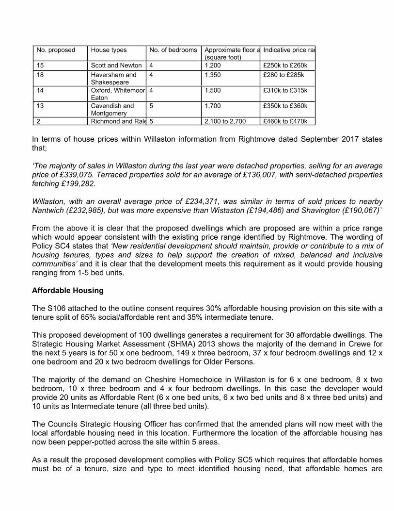
No. proposed House types No. of bedrooms Approximate floor area (square foot)
Indicative price range
15 Scott and Newton 4 1,200 £250k to £260k18 Haversham and
Shakespeare4 1,350 £280 to £285k
14 Oxford, Whitemoor and Eaton
4 1,500 £310k to £315k
13 Cavendish and Montgomery
5 1,700 £350k to £360k
2 Richmond and Raleigh5 2,100 to 2,700 £460k to £470k
In terms of house prices within Willaston information from Rightmove dated September 2017 states that;
‘The majority of sales in Willaston during the last year were detached properties, selling for an average price of £339,075. Terraced properties sold for an average of £136,007, with semi-detached properties fetching £199,282.
Willaston, with an overall average price of £234,371, was similar in terms of sold prices to nearby Nantwich (£232,985), but was more expensive than Wistaston (£194,486) and Shavington (£190,067)’
From the above it is clear that the proposed dwellings which are proposed are within a price range which would appear consistent with the existing price range identified by Rightmove. The wording of Policy SC4 states that ‘New residential development should maintain, provide or contribute to a mix of housing tenures, types and sizes to help support the creation of mixed, balanced and inclusive communities’ and it is clear that the development meets this requirement as it would provide housing ranging from 1-5 bed units.
Affordable Housing
The S106 attached to the outline consent requires 30% affordable housing provision on this site with a tenure split of 65% social/affordable rent and 35% intermediate tenure.
This proposed development of 100 dwellings generates a requirement for 30 affordable dwellings. The Strategic Housing Market Assessment (SHMA) 2013 shows the majority of the demand in Crewe for the next 5 years is for 50 x one bedroom, 149 x three bedroom, 37 x four bedroom dwellings and 12 x one bedroom and 20 x two bedroom dwellings for Older Persons.
The majority of the demand on Cheshire Homechoice in Willaston is for 6 x one bedroom, 8 x two bedroom, 10 x three bedroom and 4 x four bedroom dwellings. In this case the developer would provide 20 units as Affordable Rent (6 x one bed units, 6 x two bed units and 8 x three bed units) and 10 units as Intermediate tenure (all three bed units).
The Councils Strategic Housing Officer has confirmed that the amended plans will now meet with the local affordable housing need in this location. Furthermore the location of the affordable housing has now been pepper-potted across the site within 5 areas.
As a result the proposed development complies with Policy SC5 which requires that affordable homes must be of a tenure, size and type to meet identified housing need, that affordable homes are
dispersed throughout the site, that the market and affordable homes are undistinguishable and achieve the same design quality.
Public Open Space
Based on a development of 100 dwellings there would be a requirement for 4,500sq.m of open space on this site. This would be easily provided within the site in three pockets; on the eastern boundary, to the south-east corner and to the western boundary which measure 7,100sq.m.
The original S106 required the provision of an 8 piece NEAP on the site. In this case the developer was unable to provide the required off-set distances to the NEAP. In order to address this issue the applicant proposed that they would provide a LEAP and make a commuted payment of £35,000 to provide replacement equipment on the adjacent Parish Council owned play area. This was agreed as part of application 17/3360N and a Deed of Variation to the S106 was signed on 15th September 2017.
On this basis the development is acceptable in terms of its POS and play space provision.
In terms of the management of the POS and play area this is to be dealt with by a management company which was agreed as part of the S106 Agreement as part of the outline application which was allowed at appeal.
The open space provision on the site would comply with Policy SE6 of the CELPS which seeks to strengthen the contribution that sport, playing fields, open space and recreation facilities make through the adequate provision of open space, secure new provision to help address identified shortages, to secure the appropriate location of open space facilities and to promote linkages between new development and the surrounding recreational networks, communities and facilities.
Education
The impact upon education provision was considered at the outline stage and the S106 Agreement for the appeal application includes a contribution of £45,500 towards Special Educational Needs provision.
Health
A number of the letters of objection raise concerns about the impact upon health provision in this area. In this case there was no requirement for any contribution towards health contribution at the outline stage. This cannot be reconsidered at the reserved matters stage.
Residential Amenity
In terms of the surrounding residential properties, the properties to the north are located to the opposite side of the railway, to the east they are located to the opposite side of an area of open space, the dwellings to the south front Cheerbrook Road, Illidge Close and The Fields.
In terms of the appearance and visual impact of the noise mitigation fencing the heights were provided at the outline stage (as discussed below) and in relation to the visual impact the inspector found at paragraph 20 that;

‘Therefore whilst there would be a noticeable change in the character and appearance of the appeal site, having regard to the surrounding residential development, including that to the north of the railway line, and the relatively contained nature of the appeal site, I consider that the proposal would not significantly harm the visual character of the landscape when viewed from the playing fields’
To the north of the site the nearest proposed dwellings are those which front Beech Tree Close. In this case there would be a separation distance of 45m between the proposed dwellings and the dwellings on Beech Tree Close (to the dwellings on Park Road the closest separation distance would be 56m). In this case there would be an intervening railway line and the section drawing shows that the existing and proposed dwellings would have a similar slab level. It is considered that the proposed development would not have a detrimental impact upon the dwellings to the north of the site.
To the dwellings on the Fields there would be intervening open space and a separation distance of 40m. It is considered that the proposed development would not have a detrimental impact upon the dwellings fronting The Fields.
The separation distances to the dwellings on Cheerbrook Road are acceptable given the long separation distances to these dwellings. It is also considered that adequate separation distance would be provided to the dwellings fronting Illidge Close (Phase 1 of the development).
The Environmental Health Officer has requested conditions relating to environment management plan and construction hours. These matters are covered by Condition 12 attached to the outline consent.
As a result the proposed development complies with Policy BE.1 (Amenity) and the SPD titled ‘Development on Backland and Gardens’.
Noise
A number of objections submitted as part of this application raise concerns over the impact of the proposed acoustic fencing that will be installed along the northern boundary of the site to screen the development from the adjacent railway line. The submitted plan states that an acoustic fence will be provided along the northern boundary of the site and that the height would vary from 2m when viewed from the application site to 2.2m-4.7m when viewed from the railway (including a retaining wall) to give a height of 5 metres above the tracks of the railway line.
In this case the noise mitigation is the subject of condition 15 attached to the outline consent which states as follows;
‘No development shall commence until a noise mitigation scheme for protecting the proposed dwellings from rail traffic noise in accordance with the recommendations of the Martec Environmental Consultants Noise Assessment, dated December 2014 has been submitted to and approved in writing by the local planning authority. All works which form part of the scheme shall be completed before any dwellings to which they relate are occupied’
The Martec Environmental Consultants Noise Assessment (dated December 2014) as referred to within the condition above was submitted as part of the outline application and makes the following recommendation;

‘If it is desired to control garden noise levels, an acoustic barrier should be erected along the boundary of the site with the railway; its top/crest should be 5m above the height of the nearest section of railway; the height of the top/crest will vary above local ground height. The barrier should “return” along the western and eastern boundaries by say 20m. This barrier could be any combination of fence, walls or mound to achieve the specified height’
The assessment also makes recommendations for the mitigation of noise with the first floor windows of the bedrooms facing the railway line being upgraded to thermal glazing of the form 10mm glass/12mm air/6mm glass and Greenwood MA3051 Acoustic Wall Vent or similar and approved. The ground floor habitable rooms of the same dwellings can be mitigated to the levels specified in BS8233:2014 using standard thermal glazing and trickle vents using an indirect air path.
In this case the exact details of the noise mitigation will be determined as part of a future application to discharge condition 15 attached to the outline consent. However it should be noted that the height of the fencing will need be in accordance with the details submitted as part of the Martec Environmental Consultants Noise Assessment (5m above the height of the nearest section of railway) and referred to within condition 15 attached to the outline consent.
A number of the letters of objection raise concerns that the proposed acoustic fence would result in the deflection of the noise back across the railway to the dwellings which front Beech Tree Close and Park Road. In relation to this issue the applicant has provided an updated Noise Assessment which states that;
‘It is understood that concern has been expressed over the possible effects of railway noise being reflected back over the railway line towards the existing properties; however, the maximum effect of the reflection is 1.5dBA; given that the least discernible difference in noise levels is generally considered to be 2 to 3dBA, and then only if the change occurs immediately, it is considered that any changes are unlikely to be noticed by the existing residents’
As stated above the exact specification of the acoustic fencing will be agreed as part of condition 15 and there are numerous fence specifications which would absorb rather than deflecting sound. On this basis the Environmental Health Officer has confirmed that there is no objection in terms of noise deflection to the properties on the opposite side of the railway.
Vibration
A vibration assessment was submitted as part of the outline application to consider the existing vibration levels from rail movements and their potential impacts for future residents on the proposed development. The monitoring indicated that levels are not such as to cause an adverse impact.
Air Quality
The concerns raised in relation to air quality are noted. In this case the impact would be mitigated through the conditions attached to the outline consent; Condition 12 Environment Management Plan (including dust mitigation), Condition 13 Travel Plan and Condition 14 Electrical Vehicle Infrastructure. As a result there is no objection from the Environmental Health Officer in terms of the impact upon air quality.
Contaminated Land

The application is for new residential properties which are a sensitive end use and could be affected by any contamination present. The issue of contaminated land is controlled through the imposition of condition 16 attached to the appeal decision.
Public Rights of Way
There are no public footpaths crossing the site.
Highways
The point of access and the traffic generation as part of this development were considered as part of the outline application. It should also be noted that the S106 Agreement attached to the outline consent includes bus pass provision in the form of a public transport voucher equivalent to the cost of three x 4 weekly Arriva bus passes.
Condition 17 attached to the outline approval requires that a scheme of improvements for the Peacock Roundabout shall be submitted and implemented in accordance with a timetable which is to be agreed.
The proposed internal road does not raise any material concerns regarding width and alignment subject to there being no raised tables within the design. The level of off-street parking provided for each of the units across the development accords with CEC standards as identified in Appendix C of the CELPS and is considered acceptable.
In this case it should be noted that both conditions requested by the Strategic Highways Manager in relation to the provision of the access prior to occupation and a Construction Management Plan are attached to the outline consent (Conditions 4 and 12) and there is no need to repeat the conditions on this reserved matters application.
Trees and Hedgerows
The application is supported by a Tree Survey and Tree Protection Plan.
The original plans raised concerns in terms of the encroachment of the proposed development into the Root Protection Areas in terms of the proposed highway. The receipt of amended plans has addressed these concerns and this aspect is considered to be acceptable.
There are issues of spatial relationship and social proximity remain in respect of plot 63 and the adjacent mature Lime identified as T11. Whilst it is accepted that the adjacent property could be constructed without detrimentally impacting on the tree, providing protective fencing is maintained; there may be long term issues of light nuisance, and over bearing impact. This single tree shouldn’t be considered as a reason for refusal.
The impact upon trees and hedgerows is considered to be acceptable and complies with Policy NE.5 of the C&NLP and SE5 of the CELPS. In particular SE5 states that the Council will seek to ensure the sustainable management of trees, woodland and hedgerows including the provision of new planting (including large trees) to provide local distinctiveness within the landscape and to support biodiversity.

Design
The importance of securing high quality design is specified within the NPPF and paragraph 61 states that:
“Although visual appearance and the architecture of individual buildings are very important factors, securing high quality and inclusive design goes beyond aesthetic considerations. Therefore, planning policies and decisions should address the connections between people and places and the integration of new development into the natural, built and historic environment.”
Outline approval (Number of Dwellings/Density)
The issue of the number of dwellings and the density of the proposed development was considered by the Inspector who determined the appeal.
ConnectionsDoes the scheme integrate into its surroundings by reinforcing existing connections and creating new ones; whilst also respecting existing buildings and land uses along the boundaries of the development site?
The proposal only has a single point of vehicular access to the south and whilst this is rarely ideal given the nature of the site there are no other potential places for pedestrian/vehicular access. It was hoped that an access could be secured to the existing Parish Council owned play area to the east of the site. However the Parish Council have stated that they are not prepared to allow access from the application site.
Internally within the site vehicular movements have been improved through the provision of a central internal loop road with a reduction in the number of cul-de-sacs. Pedestrian connectivity is better with a pleasant footpath link from northeast to southwest through the open space and around the proposed play area. With regard to the edges and land uses around the site these are handled reasonably well with pedestrian access to the neighbouring open space via the new informal open space area to the eastern boundary.
Facilities and servicesDoes the development provide (or is it close to) community facilities, such as shops, schools, workplaces, parks, play areas, pubs or cafes?
This issue was considered as part of the outline application which was allowed at appeal. In this case the Inspector found that;
‘The appeal site is accessible to local shops and services, including schools. Therefore having regard to public transport services in the area, including Nantwich Station, I conclude that the appeal site occupies an accessible location’
Public transportDoes the scheme have good access to public transport to help reduce car dependency?
Again this issue was considered as part of the outline application and the Inspectors comments above apply. The developer indicates that there are five bus stops within 10 minutes walking distance of the
site and whilst these distances have clearly been calculated from the closest part of the site there are a number of bus routes accessible within walkable distances. These routes provide services to Crewe, Nantwich and Chester where national rail can be accessed. The inclusion of public transport vouchers for each dwelling as a part of the S106 agreement will encourage occupants to use public transport.
Meeting local housing requirementsDoes the development have a mix of housing types and tenures that suit local requirements?
In terms of the affordable housing on site and as discussed above the development would provide 6 x one bed units, 6 x two bed units and 18 x 3 bed units. This meets housing need in both the SHMA and Cheshire Homechoice data.
In terms of the open market housing this is discussed above with reference to Policy SC4. It is considered that the proposed mix complies with Policy SC4.
CharacterDoes the scheme create a place with a locally inspired or otherwise distinctive character?
Willaston is identified as an example settlement within the Design SPD and is located within the Salt & Engineering Towns area and the design cues for this are include the following;- A wide variety of building styles reflecting different periods in the growth of the towns. - A predominance of red brick terraces and villas.- Two-storey properties with steep roofed gables onto the street. - Boundary walls often constructed from same material as main property. - Subtle variation in detailing or colour palette creates variation between properties within long terraces.- Properties often set to back of pavement providing strong enclosure to street. - Brick of various shades and textures is the main building material. - All eras of architecture are found within the settlement character area • - Existing landscape features should be retained on site to preserve the landscape character.
There is a variation of house-types adjoining the site. The majority are two-storey in height although there are some single-storey units in the area (to the west of the access onto Cheerbrook Road and dwellings fronting The Fields to the south east) and one two-and-a-half storey dwellings along Cheerbrook Road (to the east of the access). The age of the surrounding dwellings also varies with some larger period properties and more modern dwellings which appear to be set within relatively large plots along Cheerbrook Road. To the north (along Park Road and Beech Tree Close) and to the east (along Wybunbury Road) the dwellings are more closely grouped terrace and semi-detached units.
The surrounding dwellings largely have pitched roofs but there are some properties with hipped roofs located mainly along Wybunbury Road to the east. As a general rule the dwellings which surround the site are relatively simple in their design. The dwellings in the locality of the site include a number of design features such as projecting gables (some with timber infill details but the majority in brick), bay windows (single and two-storey), window header and sill details (stone, brick, arched and flat-stopped) and chimneys. The materials in the locality are largely red brick with slate and tiled roofs (largely blue with some red).
The proposed dwellings including the apartments would all be two-storeys in height apart from a single Raleigh House Type on Plot 64 which would be two-and-a-half storeys in height. Most of the proposed dwellings would have a gabled roof design apart from the Newton, Oxford and Eton house types (a total of 16 units) which would have a hipped roof. The roof heights vary across the development which would add some interest and most of the proposed house types include chimneys. The height variation across the proposed development is consistent with the wider locality in this part of Willaston and is considered to be acceptable.
Largely it is considered that the proposed development respects this character of the area. Many of the design cues within this location are incorporated into the development with a modern design. The development includes projecting gables (most with a timber and render infill which is a design cue referenced for Willaston within the design guide), window design includes bay windows at ground floor level, brick cill and arched header details (the design guide refers to arched detailing) brick banding and finial detailing (which is a feature which is prevalent on properties further north of the site along Wistaston Road).
The perimeter block type layout is at an appropriate density with corner turning houses providing active frontages and removing the requirement for prominent blank gables within the street-scene.
The proposed materials would be red brick with a grey tiled roof. This would match the first phase of the development and complies with the Cheshire East Design Guide.
Working with the site and its contextDoes the scheme take advantage of existing topography, landscape features (including watercourses), wildlife habitats, existing buildings, site orientation and microclimates?
The site is currently open farmland with no existing buildings with the retention of the majority of existing hedgerows and mature trees to the western edge of the site. It is also positive that the site appears to open up to the existing area of public open space to the eastern edge.
The only real concern is the relationship to the railway line to the north, the housing seems relatively close to the railway but any impact could be mitigated as per the Inspectors appeal decision.
Creating well defined streets and spacesAre buildings designed and positioned with landscaping to define and enhance streets and spaces and are buildings designed to turn street corners well?
The proposed dwellings are generally positioned well in a loose perimeter block layout, front doors face the street, blocks turn corners effectively in a variety of ways creating good passive surveillance and they do define the streets and spaces. Specifically the cluster of homes at the southern gateway to the site work well and the homes on plots 90-95, front the public open space and LEAP. The clusters of homes around the home-zone type courtyards are also sensibly located.
Easy to find your way aroundIs the scheme designed to make it easy to find your way around?
The layout is legible with a wide variety of house types and a varied and interesting layout including corner turning blocks and properly terminated views all of this will aid navigation around the proposed development.

Streets for allAre streets designed in a way that encourage low vehicle speeds and allow them to function as social spaces?
There is a clear hierarchy of streets with variations in materials and shared-space mews turnings. It can be seen that all streets are designed in such a way as to reduce vehicle speeds. There is a real potential for the streets to be used as social/play spaces, specifically the shared-space areas. Overall the streets are pedestrian and cycle friendly as well as being safe for vehicles.
Car parkingIs resident and visitor parking sufficient and well integrated so that it does not dominate the street?
The level of off street parking is suitable and complies with the Councils standards. This is provided predominantly in curtilage on driveways to the front and side of homes and in small parking courts serving the two apartment blocks and the terraces of smaller two and three-bed houses. These parking courts are landscaped with short runs of adjacent bays which are located close to properties and are well overlooked.
Public and private spacesWill public and private spaces be clearly defined and designed to be attractive, well managed and safe?
The proposed development is adjacent to an existing area of public open space (although no access has been agreed with the Parish Council) that it opens up to with its own informal open space. In addition to this there is a 400m2 LEAP located at the southern edge of the site. All areas of public open space are well overlooked and would feel safe. However, there is a question over the strip of open space to the west of the established hedgerow on the western boundary. With regard to private space, every house has a private but independently accessible rear garden that is clearly defined and most homes also have gardens to the front. The apartment blocks do not have dedicated communal gardens but they are both located in close proximity to public open space.
External storage and amenity spaceIs there adequate external storage space for bins and recycling as well as vehicles and cycles?
All houses have adequately sized rear gardens with external access that are suitable for the storage of refuse and recycling bins as well as potentially cycles. The two apartment blocks have dedicated bin stores located close to the front doors. Many homes have garages, either internal or detached (the larger units have double garages).
Design Conclusion
On the basis of the above assessment it is considered that the proposed development does score well and on this basis it is considered that the design of the development is acceptable and would comply with the Cheshire East Design Guide and Policy SE1 (Design) of the CELPS).
Landscape

The wider impact upon the landscape and Green Gap was considered as part of the previous appeal decision on this site and the Inspector stated that;
‘Overall, I conclude that whilst the proposal would erode the Green Gap, it would nevertheless comply with the objectives of policy NE.4 and would not significantly harm the visual character of the landscape’
In this case the applicant has submitted a landscape scheme for the proposed development and this has been the subject of a number of revisions following concerns raised by the Councils Landscape Architect. The revised landscaping scheme is considered to be acceptable and would comply with Policies SE4 (The Landscape) and SE6 (Green Infrastructure). Policy SE4 requires that development should incorporate appropriate landscaping which reflects the character if the area, avoid the loss of habitats of significant landscape importance and protect/conserve the ecological qualities of an area.
Ecology
Bats
Four trees on site were identified at the outline stage that had the potential to support roosting bats. Two of these trees are retained as part of the proposed development and one has already been felled. The final tree (referred to as T9 on the submitted tree survey) has been subject to a detailed survey which did not record any evidence of roosting bats. As a result the Councils Ecologist advises that roosting bats are not reasonable likely to be affected by the proposed development.
Hedgerows
Hedgerows are a priority habitat and hence a material consideration. The proposed development will result in the loss of a section of hedgerow to facilitate the site entrance. The Councils Ecologist advises that the submitted landscaping proposals should be amended to include the provision of native species hedgerow planting.
Provision for Nesting Birds
If planning permission is granted the Councils Ecologist has suggested the imposition of a condition to secure nesting bird mitigation measures on this site.
Therefore it is considered that the development complies with Policies NE.5 and NE.9 of the C&NLP and SE3 (Biodiversity and Geodiversity) of the CELPS. In particular SE3 requires that all development must aim to positively contribute to the conservation and enhancement of biodiversity and geodiversity and should not negatively affect these interests.
Flood Risk/Drainage
The application site is located within Flood Zone 1 (low probability of river/tidal flooding) according to the Environment Agency Flood Maps. A Flood Risk Assessment (FRA) was submitted as part of the outline application and judged to be acceptable at that stage by the Planning Inspector.
The Planning Inspector attached a condition to the outline consent relating to the disposal of surface water and stated within her decision that
‘A scheme for the disposal of surface water, in accordance with the principles within the submitted Flood Risk Assessment, is necessary in order to ensure that the proposed dwellings would not be at risk of flooding or increase the risk of flooding elsewhere’
Agricultural Land Quality
In this case the loss of BMV agricultural land was considered as part of the outline application on this site where the Inspector found that the loss would be relatively small and that it was not a determinative factor in the appeal.
Impact upon Railway Infrastructure
As can be seen from the comments made by Network Rail there are potential concerns over the impact of the development upon the adjacent railway infrastructure and Network Rail have requested further information from the applicant. At the time of writing this report negotiations were continuing between the applicant and Network Rail and an update will be provided in relation to this issue.
Economic Benefits
With regard to the economic role of sustainable development, the proposed development will help to maintain a flexible and responsive supply of land for housing as well as bringing direct and indirect economic benefits to Willaston including additional trade for local shops and businesses, jobs in construction and economic benefits to the construction industry supply chain.
PLANNING BALANCE
The principle of development has already been accepted as part of the outline approval on this site.
Section 38(6) of the Planning and Compulsory Purchase Act 2004 requires that where in making any determination under the planning Acts, regard is to be had to the development plan; the determination shall be made in accordance with the plan unless material consideration indicates otherwise.
The development will not have a detrimental impact upon residential amenity, it would provide benefits in terms of much needed affordable housing provision and would help in the Councils delivery of 5 year housing land supply.
The impact upon infrastructure would be neutral.
In terms of the POS and play space provision this is considered to be acceptable and would be a benefit to this scheme.
The proposed landscaping scheme is acceptable.
With regard to ecological impacts, the development would have a neutral impact subject to mitigation (conditions 9-11 on the outline consent).
The drainage/flood risk implications for this proposed development are considered to be acceptable.

The proposed access point is acceptable and the traffic impact as part of this development has already been accepted. The internal design of the highway layout and parking provision is considered to be acceptable.
The design/layout of the development is considered to be acceptable and has been subject to negotiation with the developer. The design/layout is considered to comply with the Design Guide SPD.
There is no objection to this development in terms of the impact upon the trees on the site.
The development of the site would provide a number of economic benefits in the residential use of the site.
The proposed development is in accordance with the development plan and as such the NPPF recommends that the development should be approved without delay.
RECOMMENDATION:
APPROVE subject to the following conditions;1. Approved Plans2. Materials to be submitted and agreed in writing3. Approved landscaping scheme to be implemented4. Prior to the commencement of development the developer shall submit details of the LEAP
for approval in writing. The approved scheme shall be implemented prior to the first occupation of 50% of the dwellings on the site.
5. A scheme of nesting bird mitigation measures to be submitted and approved6. A scheme of hard landscaping/surfacing to be submitted and approved7. A scheme of boundary treatment to be submitted and approved8. All arboricultural works shall be carried out in accordance with TBA Arboricultural Impact
Assessment and Method Statement Phase 2 Rev B (Ref MG/4780/AIA&AMS/PHASE2/REVB/MAY17 and TBA Tree Protection Plan (Drawing No 4780.04 B) received by the Local Authority on the 19th May 2017
9. Notwithstanding the approved plans – details of a gated maintenance access to the railway shall be submitted and approved
In order to give proper effect to the Board`s/Committee’s intentions and without changing the substance of the decision, authority is delegated to the Head of Planning (Regulation), in consultation with the Chair (or in her absence the Vice Chairman) of Strategic Planning Board, to correct any technical slip or omission in the wording of the resolution, between approval of the minutes and issue of the decision notice.
