summary: draft ulp peis march 2013
TRANSCRIPT


Summary: Draft ULP PEIS March 2013
COVER SHEET 1 2 3 Lead Agency: U.S. Department of Energy (DOE) 4 5 Cooperating Agencies: The cooperating agencies are U.S. Department of the Interior (DOI), 6 Bureau of Land Management (BLM); U.S. Environmental Protection Agency (EPA); Colorado 7 Department of Transportation (CDOT); Colorado Division of Reclamation, Mining, and Safety 8 (CDRMS); Colorado Parks and Wildlife (CPW); Mesa County Commission; Montrose County 9 Commission; San Juan County Commission; San Miguel County Board of Commissioners; the 10 Pueblo of Acoma Tribe; the Pueblo de Cochiti Tribe; the Pueblo de Isleta Tribe; the Navajo 11 Nation; and the Southern Ute Indian Tribe. 12 13 Title: Draft Uranium Leasing Program Programmatic Environmental Impact Statement 14 (DOE/EIS-0472D) 15 16 For additional information on this Draft Programmatic Environmental Impact Statement (PEIS), contact: Ray Plieness, PEIS Document Manager Office of Legacy Management U.S. Department of Energy 11025 Dover Street, Suite 1000 Westminster, CO 80021 Telephone: (303) 410-4806 Fax: (720) 377-3829 E-mail: [email protected]
For general information on the DOE National Environmental Policy Act (NEPA) process, contact: Carol M. Borgstrom, Director Office of NEPA Policy and Compliance U.S. Department of Energy 1000 Independence Avenue, SW Washington, DC 20585 Telephone: (202) 585-4600, or leave a message at 1-800-472-2756 Email: [email protected]
17 Abstract: The U.S. Department of Energy (DOE) has prepared this Draft Uranium Leasing 18 Program Programmatic Environmental Impact Statement (Draft ULP PEIS) pursuant to the 19 National Environmental Policy Act of 1969 (NEPA), the Council on Environmental Quality’s 20 (CEQ’s) NEPA regulations (40 CFR Parts 1500–1508), and DOE’s NEPA implementing 21 procedures (10 CFR Part 1021) to analyze the reasonably foreseeable environmental impacts, 22 including the site-specific impacts, of the range of reasonable alternatives for the management of 23 the ULP. DOE’s ULP administers 31 tracts of land covering an aggregate of approximately 24 25,000 acres (10,000 ha) in Mesa, Montrose, and San Miguel Counties in western Colorado for 25 exploration, mine development and operations, and reclamation of uranium mines. There are 26 currently 29 existing leases; two of the lease tracts are not leased. Site-specific information 27 available on the 31 lease tracts (including current lessee information and status, size of each lease 28 tract, previous mining operations that occurred, location of existing permitted mines and 29 associated structures, and other environmental information) has been utilized as the basis for the 30 evaluation contained in this Draft ULP PEIS. 31 32 DOE has evaluated five alternatives that address the range of reasonable alternatives for the 33 management of the ULP. These alternatives are as follows: 34 35
• Alternative 1: DOE would terminate all leases, and all operations would be 36 reclaimed by lessees. DOE would continue to manage the withdrawn lands, 37 without leasing, in accordance with applicable requirements. 38

Summary: Draft ULP PEIS March 2013
• Alternative 2: Same as Alternative 1, except once reclamation was completed 1 by lessees, DOE would relinquish the lands in accordance with 2 43 CFR Part 2370. If DOI/BLM determines, in accordance with that same Part 3 of the CFR, the lands were suitable to be managed as public domain lands, 4 they would be managed by BLM under its multiple use policies. DOE’s 5 uranium leasing program would end. 6
7 • Alternative 3: DOE would continue the ULP as it existed before July 2007 8
with the 13 then-active leases, for the next 10-year period or for another 9 reasonable period, and DOE would terminate the remaining leases.1 10
11 • Alternative 4: DOE would continue the ULP with the 31 lease tracts for the 12
next 10-year period or for another reasonable period. 13 14
• Alternative 5: This is the No Action Alternative, under which DOE would 15 continue the ULP with the 31 lease tracts for the remainder of the 10-year 16 period, as the leases were when they were issued in 2008. 17
18 Preferred Alternative: DOE’s preferred alternative is Alternative 4. 19 20 Public Comments: DOE issued a Notice of Intent (NOI) to prepare the ULP PEIS in the Federal 21 Register on June 21, 2011, and a supplemental notice was issued on July 21, 2011, to announce 22 the four public scoping meetings and their locations and to announce the extension of the public 23 scoping period to September 9, 2011. Meetings were held in Montrose, Naturita, and Telluride in 24 Colorado and in Monticello, Utah. DOE has considered all input received during the scoping 25 process to prepare this Draft ULP PEIS. 26 27 A 60-day public comment period on this Draft ULP PEIS begins with the publication of the EPA 28 Notice of Availability in the Federal Register. This Draft ULP PEIS is available on the ULP web 29 site at http://ulpeis.anl.gov and on the DOE NEPA web site at http://energy.gov/nepa. DOE will 30 consider all comments postmarked or received during the comment period in preparing the Final 31 ULP PEIS. DOE will consider any comments postmarked after the comment period to the extent 32 practicable. The locations and times of the public hearings on the Draft ULP PEIS will be 33 identified in a DOE Federal Register notice and through other media, such as local press notices. 34 In addition to the public hearings, comments may also be submitted by mail or electronically via 35 the web site or e-mail at the addresses listed below. 36 37
Web site: http://ulpeis.anl.gov U.S. mail: Ray Plieness, PEIS Document Manager
Office of Legacy Management U.S. Department of Energy 11025 Dover Street, Suite 1000 Westminster, CO 80021
E-mail: [email protected]
38
1 In July 2007, DOE issued a programmatic environmental assessment and finding of no significant impact for the
ULP, which a U.S. District Court invalidated on October 18, 2011.


Summary: Draft ULP PEIS March 2013
S-iii
CONTENTS 1 2 3 NOTATION .............................................................................................................................. S-vii 4 5 CONVERSION TABLE ............................................................................................................. S-x 6 7 S.1 INTRODUCTION ........................................................................................................... S-1 8 9 S.1.1 Background .......................................................................................................... S-1 10 S.1.2 Current Status of the ULP .................................................................................... S-3 11 S.1.2.1 DOE ULP Administrative Process ...................................................... S-4 12 S.1.2.2 Lease Requirements ............................................................................ S-10 13 S.1.2.3 Site-Specific Information for the ULP Lease Tracts ........................... S-11 14 S.1.3 Purpose and Need for Agency Action ................................................................. S-21 15 S.1.4 Proposed Action ................................................................................................... S-21 16 S.1.5 Cooperating and Commenting Agencies ............................................................. S-21 17 S.1.6 Consultation ......................................................................................................... S-23 18 19 S.2 NEPA PROCESS FOR THE ULP PEIS ......................................................................... S-23 20 21 S.2.1 Public Involvement .............................................................................................. S-24 22 S.2.1.1 Comments Considered within ULP PEIS Scope ................................. S-25 23 S.2.1.2 Comments Considered outside ULP PEIS Scope ............................... S-27 24 25 S.3 SCOPE OF THE DRAFT ULP PEIS .............................................................................. S-27 26 27 S.3.1 Alternatives Evaluated in the Draft ULP PEIS .................................................... S-28 28 S.3.1.1 Alternative 1 ........................................................................................ S-29 29 S.3.1.2 Alternative 2 ........................................................................................ S-32 30 S.3.1.3 Alternative 3 ........................................................................................ S-32 31 S.3.1.4 Alternative 4 ........................................................................................ S-36 32 S.3.1.5 Alternative 5 ........................................................................................ S-38 33 S.3.2 Preferred Alternative ............................................................................................ S-39 34 S.3.3 Alternatives Considered but Not Evaluated in Detail .......................................... S-39 35 36 S.4 SUMMARY AND COMPARISON OF POTENTIAL ENVIRONMENTAL 37 IMPACTS ........................................................................................................................ S-40 38 39 S.5 MEASURES TO MINIMIZE POTENTIAL IMPACTS FROM ULP 40 MINING ACTIVITIES.................................................................................................... S-59 41 42 S.6 CUMULATIVE IMPACTS ............................................................................................. S-73 43 44 S.7 HOW THE PUBLIC CAN PARTICIPATE .................................................................... S-80 45

Summary: Draft ULP PEIS March 2013
S-iv
CONTENTS (Cont.) 1 2 3 S.8 LOCATIONS AND DATES OF THE PUBLIC HEARINGS ........................................ S-81 4 5 S.9 REFERENCES ................................................................................................................ S-81 6 7 8
FIGURES 9 10 11 S.1-1 Locations of the 31 ULP Lease Tracts in Colorado ...................................................... S-8 12 13 S.1-2 Location of Lease Tracts 5, 5A, 6, 7, 8, 8A, and 9 ....................................................... S-13 14 15 S.1-3 Location of Lease Tracts 11, 11A, 12, 13, 13A, 14, 15, and 15A ................................ S-17 16 17 S.1-4 Location of Least Tract 18 ............................................................................................ S-20 18 19 S.2-1 NEPA Process for the ULP PEIS.................................................................................. S-24 20 21 S.3-1 Locations of Lease Tracts Evaluated under Alternatives 1 and 2 ................................. S-30 22 23 S.3-2 Locations of Lease Tracts Evaluated under Alternative 3 ............................................ S-33 24 25 S.6-1 Region of Cumulative Effects ....................................................................................... S-74 26 27 28
TABLES 29 30 31 S.1-1 Summary of Three Leasing Programs Administered between 1949 and 2008 ............ S-2 32 33 S.1-2 Summary of the 31 DOE ULP Lease Tracts in 2011 .................................................... S-5 34 35 S.1-3 Estimated Remaining Ore Reserve at the ULP Lease Tracts ....................................... S-12 36 37 S.3-1 Lease Tracts Evaluated under Alternatives 1 and 2 ...................................................... S-31 38 39 S.3-2 Lease Tracts Evaluated under Alternative 3 ................................................................. S-34 40 41 S.4-1 Definition of Impact Levels .......................................................................................... S-41 42 43 S.4-2 Comparison of the Potential Impacts on Air Quality, the Acoustic 44 Environment, and Soil Resources from Alternatives 1 through 5 ................................ S-44 45
Summary: Draft ULP PEIS March 2013
S-v
TABLES (Cont.) 1 2 3 S.4-3 Comparison of the Potential Impacts on Water Resources, Land Use, and 4 Waste Management from Alternatives 1 through 5 ...................................................... S-47 5 6 S.4-4 Comparison of the Potential Impacts on Human Health from 7 Alternatives 1 through 5 ................................................................................................ S-49 8 9 S.4-5 Comparison of the Potential Impacts on Ecological Resources from 10 Alternatives 1 through 5 ................................................................................................ S-52 11 12 S.4-6 Comparison of the Potential Impacts on Socioeconomics, Environmental 13 Justice, and Transportation from Alternatives 1 through 5 ........................................... S-55 14 15 S.4-7 Comparison of the Potential Impacts on Cultural Resources and Visual 16 Resources from Alternatives 1 through 5 ..................................................................... S-57 17 18 S.5-1 Measures Identified to Minimize Potential Impacts from Uranium Mining 19 at the ULP Lease Tracts ................................................................................................ S-60 20 21

Summary: Draft ULP PEIS March 2013
S-vi
1 2 3 4 5 6 7 8 9 10 11 12
This page intentionally left blank 13 14
15

Summary: Draft ULP PEIS March 2013
S-vii
NOTATION 1 2 3 The following is a list of acronyms and abbreviations, chemical names, and units of 4 measure used in the Summary. 5 6 7 ACRONYMS AND ABBREVIATIONS 8 9 AEA Atomic Energy Act 10 AEC Atomic Energy Commission 11 12 13 BA biological assessment 14 BLM Bureau of Land Management 15 BMP best management practice 16 17 CDOT Colorado Department of Transportation 18 CDPHE Colorado Department of Public Health and Environment 19 CDRMS Colorado Division of Reclamation, Mining, and Safety 20 CEQ Council on Environmental Quality 21 CFR Code of Federal Regulations 22 CPW Colorado Parks and Wildlife 23 24 DOE U.S. Department of Energy 25 DOI U.S. Department of the Interior 26 27 EIS environmental impact statement 28 EPA U.S. Environmental Protection Agency 29 ESA Endangered Species Act 30 31 FONSI Finding of No Significant Impact 32 FR Federal Register 33 34 ISL in situ leaching 35 36 LCF latent cancer fatality 37 38 MOU Memorandum of Understanding 39 40 NEPA National Environmental Policy Act 41 NHPA National Historic Preservation Act 42 NOI Notice of Intent 43 NRC U.S. Nuclear Regulatory Commission 44 45

Summary: Draft ULP PEIS March 2013
S-viii
PEA programmatic environmental assessment 1 PEIS programmatic environmental impact statement 2 P.L. Public Law 3 PLO Public Land Order 4 PM particulate matter 5 PM2.5 particulate matter with a mean diameter of 2.5 µm or less 6 PM10 particulate matter with a mean diameter of 10 µm or less 7 8 ROD Record of Decision 9 ROI region of influence 10 ROW right-of-way 11 12 ULP Uranium Leasing Program 13 USC United States Code 14 USFWS U.S. Fish and Wildlife Service 15 16 WL working level 17 18 19 UNITS OF MEASURE 20 21 ac-ft acre-foot (feet) 22 23 cm centimeter(s) 24 25 dBA a-weighted decibel(s) 26 27 ft foot (feet) 28 29 gal gallon(s) 30 31 h hour(s) 32 ha hectare(s) 33 34 in. inch(es) 35 36 kg kilogram(s) 37 km kilometer(s) 38 39 lb pound(s) 40 41 m meter(s) 42 mi mile(s) 43 mrem millirem 44 45

Summary: Draft ULP PEIS March 2013
S-ix
ppm part(s) per million 1 2 rem roentgen equivalent man 3 4 s second(s) 5 6 yr year(s) 7 8
9

Summary: Draft ULP PEIS March 2013
S-x
CONVERSION TABLE 1 ENGLISH/METRIC AND METRIC/ENGLISH EQUIVALENTS 2
3 4
Multiply
By
To Obtain
English/Metric Equivalents Acres 0.004047 square kilometers (km2) acre-feet (ac-ft) 1,234 cubic meters (m3) cubic feet (ft3) 0.02832 cubic meters (m3) cubic yards (yd3) 0.7646 cubic meters (m3) degrees Fahrenheit (ºF) –32 0.5555 degrees Celsius (ºC) feet (ft) 0.3048 meters (m) gallons (gal) 3.785 liters (L) gallons (gal) 0.003785 cubic meters (m3) inches (in.) 2.540 centimeters (cm) miles (mi) 1.609 kilometers (km) miles per hour (mph) 1.609 kilometers per hour (kph) pounds (lb) 0.4536 kilograms (kg) short tons (tons) 907.2 kilograms (kg) short tons (tons) 0.9072 metric tons (t) square feet (ft2) 0.09290 square meters (m2) square yards (yd2) 0.8361 square meters (m2) square miles (mi2) 2.590 square kilometers (km2) yards (yd) 0.9144 meters (m) Metric/English Equivalents centimeters (cm) 0.3937 inches (in.) cubic meters (m3) 0.00081 acre-feet (ac-ft) cubic meters (m3) 35.31 cubic feet (ft3) cubic meters (m3) 1.308 cubic yards (yd3) cubic meters (m3) 264.2 gallons (gal) degrees Celsius (ºC) +17.78 1.8 degrees Fahrenheit (ºF) hectares (ha) 2.471 Acres kilograms (kg) 2.205 pounds (lb) kilograms (kg) 0.001102 short tons (tons) kilometers (km) 0.6214 miles (mi) kilometers per hour (kph) 0.6214 miles per hour (mph) liters (L) 0.2642 gallons (gal) meters (m) 3.281 feet (ft) meters (m) 1.094 yards (yd) metric tons (t) 1.102 short tons (tons) square kilometers (km2) 247.1 Acres square kilometers (km2) 0.3861 square miles (mi2) square meters (m2) 10.76 square feet (ft2) square meters (m2) 1.196 square yards (yd2)
5

Summary: Draft ULP PEIS March 2013
S-1
S.1 INTRODUCTION 1 2 The U.S. Department of Energy (DOE) has prepared the Uranium Leasing Program 3 (ULP) Programmatic Environmental Impact Statement (PEIS) pursuant to the National 4 Environmental Policy Act of 1969 (NEPA) (Title 42, Section 4321 and following sections of the 5 United States Code [42 USC 4321 et seq.]), the Council on Environmental Quality’s (CEQ’s) 6 NEPA regulations found in Title 40 of the Code of Federal Regulations (40 CFR Parts 1500–7 1508), and DOE’s NEPA implementing procedures (10 CFR Part 1021) in order to analyze the 8 reasonably foreseeable environmental impacts, including the site-specific impacts, of alternatives 9 for the management of the ULP. DOE’s ULP administers tracts of land located in Mesa, 10 Montrose, and San Miguel Counties in western Colorado for the exploration, mine development 11 and operations, and extraction of uranium and vanadium ores. 12 13 14 S.1.1 Background 15 16 Congress authorized DOE’s predecessor agency, the U.S. Atomic Energy Commission 17 (AEC), to develop a supply of domestic uranium. In 1948, the Bureau of Land Management 18 (BLM) issued Public Land Order (PLO) 459, which stated, “Subject to valid existing rights and 19 existing withdrawals, the public lands and the minerals reserved to the United States in the 20 patented lands in the following areas in Colorado are hereby withdrawn from all forms of 21 appropriation under the public-land laws, including the mining laws but not the mineral-leasing 22 laws, and reserved for the use of the United States Atomic Energy Commission.” Subsequently, 23 other PLOs increased or decreased the total acreage of the withdrawn lands. In addition, the 24 Federal Government, through the Union Mines Development Corporation, acquired a substantial 25 number of patented and unpatented mining claims, mill and tunnel site claims, and agricultural 26 patents, until the aggregated acreage managed by AEC totaled approximately 25,000 acres 27 (10,000 ha). The areas under consideration are located in western Colorado in Mesa, Montrose, 28 and San Miguel Counties. 29 30 Beginning in 1949, the AEC and its successor agencies, the U.S. Energy Research and 31 Development Administration and DOE, administered three separate and distinct leasing 32 programs during the ensuing 60 years, as summarized in Table S.1-1. To put the production 33 numbers in Table S.1-1 in perspective, domestic annual uranium production peaked in 1980 at 34 about 44 million lb (20 million kg), of which lease production that year represented about 2.5% 35 of the total. In addition, today’s world market produces approximately 100 million lb 36 (45 million kg) of uranium annually. 37 38 In preparing for the 1974 leasing period, the AEC evaluated the potential environmental 39 and economic impacts related to the leasing program. This evaluation was documented in 40 Environmental Statement, Leasing of AEC Controlled Uranium Bearing Lands (AEC 1972). In 41 1995, DOE again evaluated the potential environmental and economic impacts related to the 42 leasing program and documented its findings in the Finding of No Significant Impact for the 43 Uranium Lease Management Program (DOE 1995). 44 45

Summary: Draft ULP PEIS March 2013
S-2
TABLE S.1-1 Summary of Three Leasing Programs 1 Administered between 1949 and 2008 2
Lease Production
(million lb)a
Years of No. of Royalties Generated Operation Leases U3O8 V2O5 ($ million)
1949–1962 48 1.2 6.8 5.9 1974–1994b 43 6.5 33.0 53.0 1996–2008 15 0.3 1.4 4.0
Total 8.0 41.2 62.9 a Uranium ore is generated as uranium oxide (U3O8) and vanadium ore is
generated as vanadium oxide (V2O5).
b Mining operations peaked in 1980. 3 4 When the first leasing program ended in 1962, the AEC directed the lessees to close the 5 mines (to prohibit unauthorized entry), but little was done to reclaim the mine sites. These mine 6 sites became DOE’s “legacy sites,” discussed later in this section. 7 8 In 1974, the AEC initiated reclamation bonding requirements in its new lease agreements 9 that ensured that all mine sites would be adequately reclaimed when lease operations ended. 10 During this period, a new lessee could elect to incorporate an existing mine (from the previous 11 leasing program) into its current operation. By so doing, the new lessee accepted the 12 responsibility and liability associated with the ultimate reclamation of that mine site. 13 14 In October 1994, DOE initiated a mine-site reconnaissance and reclamation project on 15 the lease tracts. Each lease tract was thoroughly inspected to identify all the abandoned mine 16 sites that resulted from pre-1974 leasing activities. After this identification process, all the 17 mining-related features associated with each site were quantified and assessed for their historic 18 importance. In 1995, in the absence of specific guidance pursuant to the reclamation of 19 abandoned uranium mine sites, DOE initiated discussions with BLM officials (state and local) 20 that culminated in the establishment of a guidance document, Uranium Closure/Reclamation 21 Guidelines (BLM 1995) for such sites. DOE’s objective in establishing this guidance document 22 was to ensure that DOE’s lease tracts were reclaimed in a manner that was acceptable to BLM, 23 so that the lands could be restored to the public domain and managed by BLM. Subsequently, 24 DOE’s “legacy” mine sites were prioritized and systematically reclaimed. Reclamation at the 25 final legacy mine site was completed in May 2001. DOE reclaimed a total of 161 separate mine 26 sites on 22 lease tracts at a total cost of $1.25 million. 27 28 29
Summary: Draft ULP PEIS March 2013
S-3
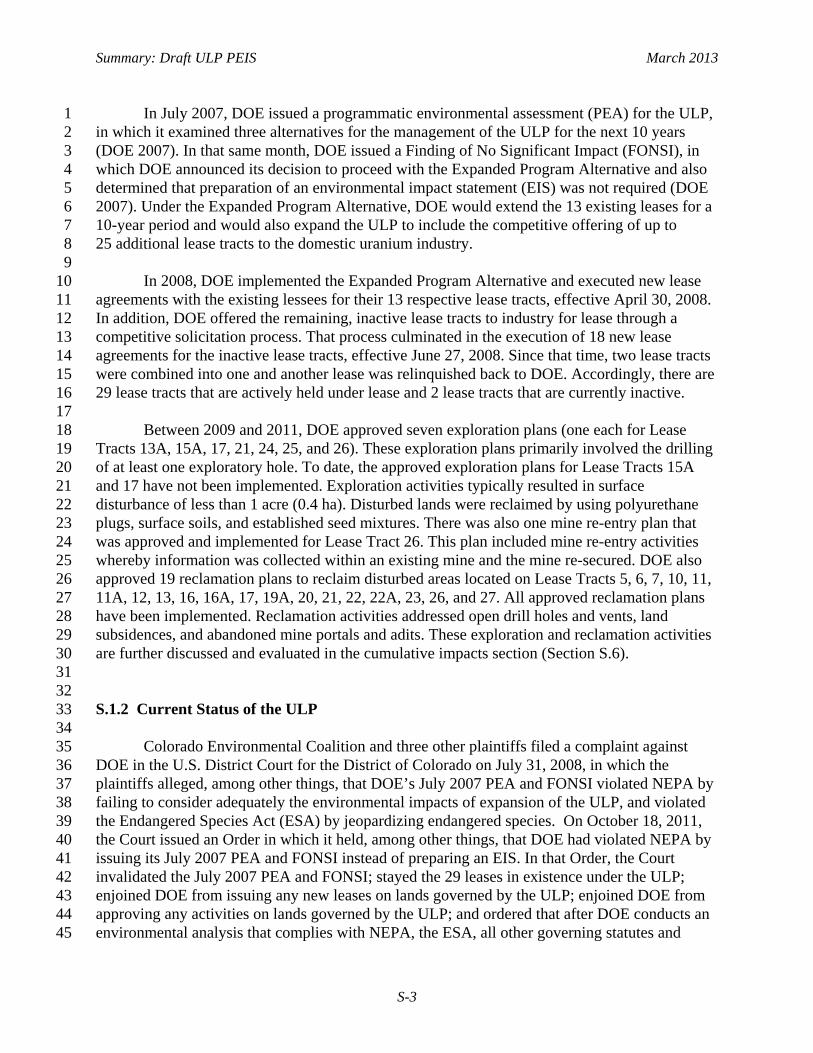
In July 2007, DOE issued a programmatic environmental assessment (PEA) for the ULP, 1 in which it examined three alternatives for the management of the ULP for the next 10 years 2 (DOE 2007). In that same month, DOE issued a Finding of No Significant Impact (FONSI), in 3 which DOE announced its decision to proceed with the Expanded Program Alternative and also 4 determined that preparation of an environmental impact statement (EIS) was not required (DOE 5 2007). Under the Expanded Program Alternative, DOE would extend the 13 existing leases for a 6 10-year period and would also expand the ULP to include the competitive offering of up to 7 25 additional lease tracts to the domestic uranium industry. 8 9 In 2008, DOE implemented the Expanded Program Alternative and executed new lease 10 agreements with the existing lessees for their 13 respective lease tracts, effective April 30, 2008. 11 In addition, DOE offered the remaining, inactive lease tracts to industry for lease through a 12 competitive solicitation process. That process culminated in the execution of 18 new lease 13 agreements for the inactive lease tracts, effective June 27, 2008. Since that time, two lease tracts 14 were combined into one and another lease was relinquished back to DOE. Accordingly, there are 15 29 lease tracts that are actively held under lease and 2 lease tracts that are currently inactive. 16 17
Between 2009 and 2011, DOE approved seven exploration plans (one each for Lease 18 Tracts 13A, 15A, 17, 21, 24, 25, and 26). These exploration plans primarily involved the drilling 19 of at least one exploratory hole. To date, the approved exploration plans for Lease Tracts 15A 20 and 17 have not been implemented. Exploration activities typically resulted in surface 21 disturbance of less than 1 acre (0.4 ha). Disturbed lands were reclaimed by using polyurethane 22 plugs, surface soils, and established seed mixtures. There was also one mine re-entry plan that 23 was approved and implemented for Lease Tract 26. This plan included mine re-entry activities 24 whereby information was collected within an existing mine and the mine re-secured. DOE also 25 approved 19 reclamation plans to reclaim disturbed areas located on Lease Tracts 5, 6, 7, 10, 11, 26 11A, 12, 13, 16, 16A, 17, 19A, 20, 21, 22, 22A, 23, 26, and 27. All approved reclamation plans 27 have been implemented. Reclamation activities addressed open drill holes and vents, land 28 subsidences, and abandoned mine portals and adits. These exploration and reclamation activities 29 are further discussed and evaluated in the cumulative impacts section (Section S.6). 30 31 32 S.1.2 Current Status of the ULP 33 34 Colorado Environmental Coalition and three other plaintiffs filed a complaint against 35 DOE in the U.S. District Court for the District of Colorado on July 31, 2008, in which the 36 plaintiffs alleged, among other things, that DOE’s July 2007 PEA and FONSI violated NEPA by 37 failing to consider adequately the environmental impacts of expansion of the ULP, and violated 38 the Endangered Species Act (ESA) by jeopardizing endangered species. On October 18, 2011, 39 the Court issued an Order in which it held, among other things, that DOE had violated NEPA by 40 issuing its July 2007 PEA and FONSI instead of preparing an EIS. In that Order, the Court 41 invalidated the July 2007 PEA and FONSI; stayed the 29 leases in existence under the ULP; 42 enjoined DOE from issuing any new leases on lands governed by the ULP; enjoined DOE from 43 approving any activities on lands governed by the ULP; and ordered that after DOE conducts an 44 environmental analysis that complies with NEPA, the ESA, all other governing statutes and 45

Summary: Draft ULP PEIS March 2013
S-4
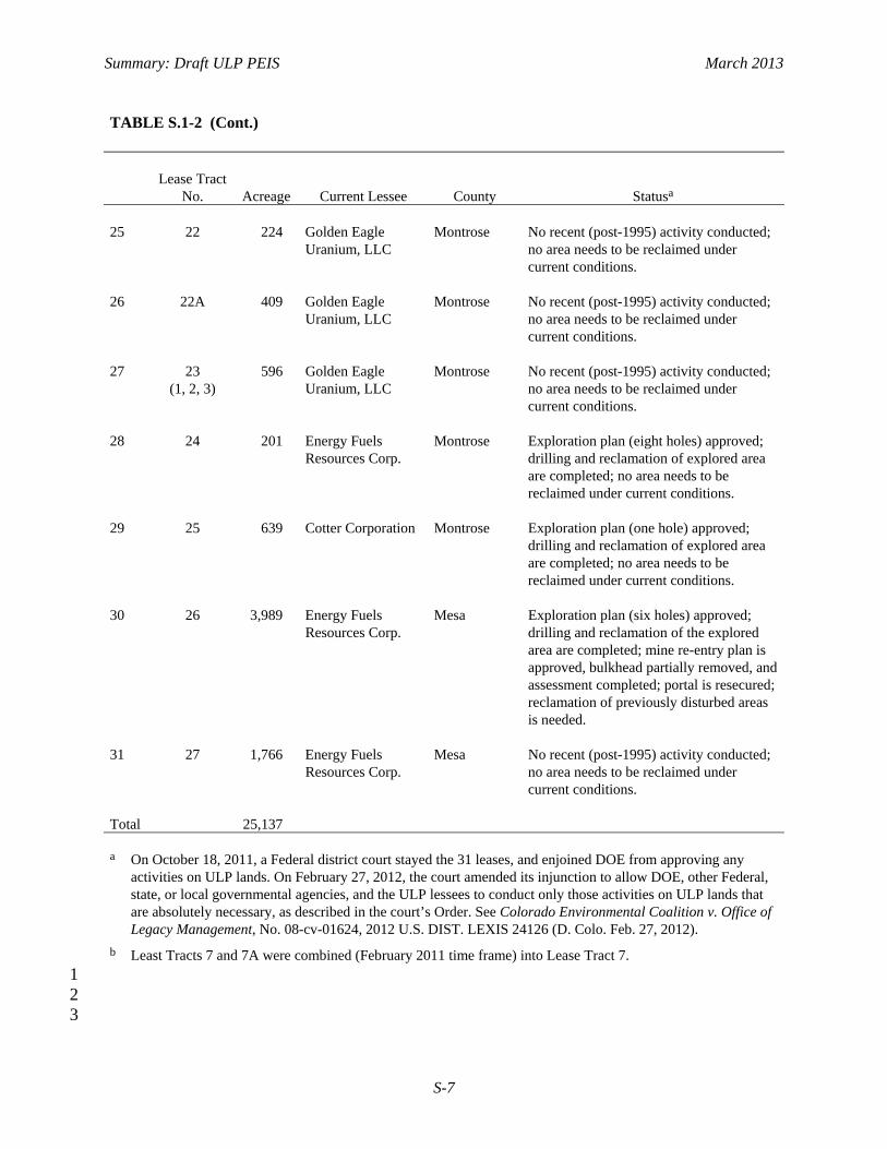
regulations, and the Court’s Order, DOE could then move the Court to dissolve its injunction 1 (Colorado Environmental Coalition v. DOE, No. 08-cv-1624 [D. Colo. Oct. 18, 2011]). 2 3 The Court later granted in part DOE’s motion for reconsideration of that Order and 4 amended its injunction to allow DOE; other Federal, state, or local governmental agencies; 5 and/or the ULP lessees to conduct only those activities on ULP lands that are absolutely 6 necessary: (1) to conduct DOE’s environmental analysis regarding the ULP; (2) to comply with 7 orders from Federal, state, or local government regulatory agencies; (3) to remediate certain 8 dangers to public health, safety, and the environment on ULP lands; and (4) to conduct certain 9 activities to maintain the ULP lease tracts and their existing facilities (Colorado Environmental 10 Coalition v. DOE, No. 08-cv-1624 [D. Colo. Feb. 27, 2012]). 11 12 On June 21, 2011, DOE published the Notice of Intent (NOI) to prepare the PEIS 13 (see Volume 76, page 36097 of the Federal Register [76 FR 36097]). In the NOI, DOE stated 14 that it had determined, in light of the site-specific information that it had gathered as a result of 15 the site-specific agency actions proposed and approved pursuant to the July 2007 PEA, that it 16 was appropriate for DOE to prepare a PEIS in order to analyze the reasonably foreseeable 17 environmental impacts, including the site-specific impacts, of a range of alternatives for the 18 management of the ULP for the remainder of the 10-year period that was covered by the 19 July 2007 PEA. After DOE published the NOI, it notified the ULP lessees that until the PEIS 20 process was completed, DOE would not approve any new exploration and mining plans and 21 would not require any lessees to pay royalties. 22 23 Currently, of the 31 ULP lease tracts, 29 have active leases. Two do not—Lease 24 Tracts 8A and 14 (Parcels 14-1, 14-2, and 14-3) are currently not leased. Lease Tract 8A is a 25 small tract that is isolated and may be located entirely below (or outside) the uranium-bearing 26 formation, which could indicate a lack of ore. Lease Tract 14 comprises three parcels (14-1, 27 14-2, and 14-3). There was some interest in Parcels 14-1 and 14-2 by potential lessees in the 28 past; however, the third parcel (14-3, which lies east of Parcel 14-1) is located almost entirely 29 within the Dolores River corridor and was never leased. Table S.1-2 lists the 31 lease tracts with 30 applicable acreage, current lessee, and status of each. Figure S.1-1 shows the locations of the 31 31 ULP lease tracts. 32 33 34
S.1.2.1 DOE ULP Administrative Process 35 36 DOE’s administration of the ULP includes the actions needed to manage the activities 37 conducted at the 31 lease tracts. Table S.1-2 lists the 31 lease tracts with applicable acreage, 38 current lessee, and the status of each. Figure S.1-1 shows the locations of the 31 ULP lease 39 tracts. These actions are undertaken to assure that the program’s technical and administrative 40 objectives are accomplished, as listed below: 41 42
• Offer the lease tracts to the domestic uranium industry through a competitive 43 royalty-bid process that culminates in the award of each lease to the highest 44 qualified bidder. 45

Summary: Draft ULP PEIS March 2013
S-5
TABLE S.1-2 Summary of the 31 DOE ULP Lease Tracts in 2011 1
Lease Tract
No. Acreage Current Lessee County Statusa
1 10 638 Golden Eagle
Uranium, LLC San Miguel No recent (post-1995) activity conducted;
no area needs to be reclaimed under current conditions.
2 11 1,303 Cotter Corporation San Miguel One new underground mine permitted and
developed; reclamation of previously disturbed areas needed.
3 11A 1,297 Golden Eagle
Uranium, LLC San Miguel No recent (post-1995) activity conducted;
no area needs to be reclaimed under current conditions.
4 12 641 Colorado Plateau
Partners San Miguel No recent (post-1995) activity conducted;
no area needs to be reclaimed under current conditions.
5 13 1,077 Gold Eagle Mining,
Inc. San Miguel Three existing, permitted underground
mines; reclamation of previously disturbed areas is needed.
6 13A 420 Cotter Corporation San Miguel Exploration plan (one hole) approved;
drilling and reclamation of the explored area are completed.
7b 14
(1, 2, 3) 971 Not applicable San Miguel Lease tract not currently leased.
8 15 350 Gold Eagle Mining,
Inc. San Miguel One existing underground mine;
reclamation of previously disturbed areas is needed.
9 15A 172 Golden Eagle
Uranium, LLC San Miguel No recent (post-1995) activity conducted;
no area needs to be reclaimed under current conditions.
10 16 1,790 Golden Eagle
Uranium, LLC San Miguel No recent (post-1995) activity conducted;
no area needs to be reclaimed under current conditions.
11 16A 585 Energy Fuels
Resources Corp. San Miguel No recent (post-1995) activity conducted;
no area needs to be reclaimed under current conditions.
12 5 151 Gold Eagle Mining,
Inc. Montrose One existing, permitted underground
mine; reclamation of previously disturbed areas is needed.
2

Summary: Draft ULP PEIS March 2013
S-6
TABLE S.1-2 (Cont.)
Lease Tract
No. Acreage Current Lessee County Statusa 13 5A
(1, 2) 25 Golden Eagle
Uranium, LLC Montrose No recent (post-1995) activity conducted;
no area needs to be reclaimed under current conditions.
14 6 530 Cotter Corporation Montrose One existing permitted underground mine;
reclamation of previously disturbed areas is needed.
15 7 493 Cotter Corporation Montrose Two existing permitted mines—one
underground mine and one large open-pit mine; reclamation of previously disturbed areas is needed.
16 8 955 Cotter Corporation Montrose One existing permitted underground mine;
reclamation of previously disturbed areas is needed.
17 8A 78 Not applicable Montrose Lease tract has not been leased. 18 9 1,037 Cotter Corporation Montrose One existing permitted underground mine;
reclamation of previously disturbed areas is needed.
19 17
(1, 2) 475 Golden Eagle
Uranium, LLC Montrose and San Miguel
No recent (post-1995) activity conducted; no area needs to be reclaimed under current conditions.
20 18 1,181 Cotter Corporation Montrose One existing permitted underground mine;
reclamation of previously disturbed areas is needed.
21 19 662 Energy Fuels
Resources Corp. Montrose No recent (post-1995) activity conducted;
no area needs to be reclaimed under current conditions.
22 19A 1,204 Energy Fuels
Resources Corp. Montrose No recent (post-1995) activity conducted;
no area needs to be reclaimed under current conditions.
23 20 627 Energy Fuels
Resources Corp. Montrose No recent (post-1995) activity conducted;
no area needs to be reclaimed under current conditions.
24 21 651 Cotter Corporation Montrose Exploration plan (two holes) approved;
drilling and reclamation of the explored area are completed; no area needs to be reclaimed under current conditions.
Summary: Draft ULP PEIS March 2013
S-7
TABLE S.1-2 (Cont.)
Lease Tract
No. Acreage Current Lessee County Statusa 25 22 224 Golden Eagle
Uranium, LLC Montrose No recent (post-1995) activity conducted;
no area needs to be reclaimed under current conditions.
26 22A 409 Golden Eagle
Uranium, LLC Montrose No recent (post-1995) activity conducted;
no area needs to be reclaimed under current conditions.
27 23
(1, 2, 3) 596 Golden Eagle
Uranium, LLC Montrose No recent (post-1995) activity conducted;
no area needs to be reclaimed under current conditions.
28 24 201 Energy Fuels
Resources Corp. Montrose Exploration plan (eight holes) approved;
drilling and reclamation of explored area are completed; no area needs to be reclaimed under current conditions.
29 25 639 Cotter Corporation Montrose Exploration plan (one hole) approved;
drilling and reclamation of explored area are completed; no area needs to be reclaimed under current conditions.
30 26 3,989 Energy Fuels
Resources Corp. Mesa Exploration plan (six holes) approved;
drilling and reclamation of the explored area are completed; mine re-entry plan is approved, bulkhead partially removed, and assessment completed; portal is resecured; reclamation of previously disturbed areas is needed.
31 27 1,766 Energy Fuels
Resources Corp. Mesa No recent (post-1995) activity conducted;
no area needs to be reclaimed under current conditions.
Total 25,137 a On October 18, 2011, a Federal district court stayed the 31 leases, and enjoined DOE from approving any
activities on ULP lands. On February 27, 2012, the court amended its injunction to allow DOE, other Federal, state, or local governmental agencies, and the ULP lessees to conduct only those activities on ULP lands that are absolutely necessary, as described in the court’s Order. See Colorado Environmental Coalition v. Office of Legacy Management, No. 08-cv-01624, 2012 U.S. DIST. LEXIS 24126 (D. Colo. Feb. 27, 2012).
b Least Tracts 7 and 7A were combined (February 2011 time frame) into Lease Tract 7. 1 2
3

Summary: Draft ULP PEIS March 2013
S-8
1
FIGURE S.1-1 Locations of the 31 ULP Lease Tracts in Colorado 2

Summary: Draft ULP PEIS March 2013
S-9
• Inspect and maintain lease tract boundary markers and monuments on the 1 lease tracts. Establish and maintain records of survey control points for said 2 markers and monuments. 3
4 • Review lessees’ exploration and mining plans, in coordination with BLM and 5
the Colorado Division of Reclamation, Mining and Safety (CDRMS), to 6 ensure that they are consistent with Federal, state, and local rules and 7 regulations; existing environmental regulations; lease stipulations; and 8 standard industry practices. Approve or deny each plan as warranted. 9
10 • Coordinate with other Federal agencies (e.g., BLM, U.S. Fish and Wildlife 11
Service [USFWS], U.S Environmental Protection Agency [EPA]), state 12 agencies (e.g., CDRMS, Colorado Division of Parks and Wildlife [CPW], 13 Colorado Department of Public Health and the Environment [CDPHE]), local 14 and tribal officials, and private entities as appropriate to address concerns that 15 they may have. Routinely review each Memorandum of Understanding 16 established with BLM and CDRMS to ensure that the agreements remain up 17 to date and reflect actual work practices. 18
19 • Establish the amount of reclamation performance bonding appropriate for the 20
amount of environmental disturbance anticipated based on an evaluation of 21 the lessees’ proposed activities, including site-specific access routes, 22 exploration drill-hole locations, mine-site support facility locations, and 23 proposed methods of reclamation. 24
25 • Monitor lessees’ exploration, mine-development, and ore-production activities 26
to ensure compliance with Federal, state, and local environmental regulations 27 and lease stipulations. Identify adverse conditions that need to be addressed 28 and advise the lessees accordingly. 29
30 • Review exploration drill-hole logs, drill-hole maps, mine maps, and quarterly 31
reports submitted by the lessees to assess the lessees’ progress and verify 32 conditions witnessed during field inspections. 33
34 • Review Federal and state mine safety inspection records and reports to 35
identify significant violations or adverse trends and determine whether actions 36 are warranted. 37
38 • Monitor and track market prices (spot and long term) for uranium oxide 39
(U3O8) and vanadium oxide (V2O5) (uranium ore is generated as uranium 40 oxide and vanadium ore is generated as vanadium oxide) and keep abreast of 41 activities occurring within the world uranium and vanadium industries. 42
43 • Develop and maintain procedures to process and maintain records of ores 44
produced from the DOE lease tracts and delivered to a mill or other receiving 45
Summary: Draft ULP PEIS March 2013
S-10
station for processing. Calculate the resulting royalties due and payable to 1 DOE. Ensure that royalty payments are submitted in accordance with the lease 2 agreements. Maintain records associated with the number of miles traveled by 3 ore trucks on Federal, state, and county roadways. Ensure that lessees’ pulp 4 ore samples are analyzed in accordance with lease agreement requirements. 5
6 • Maintain a record of and provide for the routine surveillance of concurrent 7
surface activities (e.g., activities associated with oil and gas leases and special 8 use permits) that are authorized by other agencies with surface-management 9 jurisdiction. 10
11 • Evaluate sample plants to verify that they or other facilities receiving lease 12
tract ores have adequate procedures for weighing, sampling, and assaying said 13 ores and for reporting the results to DOE. 14
15 • Monitor lessees’ reclamation activities to ensure that they comply with 16
Federal, state, and local environmental regulations and lease stipulations. 17 Ensure that these activities are consistent with existing exploration and mining 18 plans and standard industry practices. Monitor post-reclamation sites for 3 to 19 5 years to assure that adequate vegetation is successfully re-established at the 20 site. 21
22 • Oversee the relinquishment of lease agreements when requested by a lessee or 23
the termination of lease agreements for cause when directed by DOE. 24 25 Determine the eligibility of inactive, reclaimed lease tracts for restoration to the public 26 domain under BLM’s management . Prepare a Request to Relinquish Lands and submit it to the 27 BLM Colorado State Office for processing. Help BLM officials review the Request, and monitor 28 its status until the restoration process is complete. 29 30 31
S.1.2.2 Lease Requirements 32 33 Two generic leases are currently utilized for the DOE ULP and could be modified in the 34 future as a result of this ULP PEIS process. Both generic leases are the same except for how the 35 royalty payment is determined. Before conducting any exploratory or mining activity, the lessee 37 is required to file a “Notice of Intent to Conduct Prospecting Operations” or “Reclamation 38 Permit Application” with the Colorado Mined Land Reclamation Board for the review and 39 approval of CDRMS. The lessee is then required to submit three copies of a detailed Exploration 40 Plan or Mining Plan to DOE. This plan must include a site-specific environmental analysis and a 41 description of measures to be taken to ensure compliance with all Federal, state, and local laws. 42 In addition, the lessee must consult with all pertinent Federal, state, and local agencies—43 including, but not limited to, the BLM, USFWS, U.S. Army Corps of Engineers (USACE), EPA, 44 CPW, State Historic Preservation Officer (SHPO), and Indian tribal governments—to determine 45 the presence and/or location of all endangered, threatened, and sensitive plant and wildlife 46

Summary: Draft ULP PEIS March 2013
S-11
species; known cultural resources; and floodplain and wetland areas. Plans are reviewed by 1 DOE, and upon DOE’s approval, the actions described in the plan can commence. DOE and 2 other appropriate agencies must be notified in writing if the lessee wishes to change part of the 3 plan, and no change can take place until approval is given. After the plan is approved, but before 4 any ground-disturbing activity can commence, the lessee must file a performance bond (the 5 amount is established by DOE) in coordination with CDRMS. This coordination is reflected in 6 the Memorandum of Understanding (MOU) between DOE and CDRMS (DOE and 7 CDRMS 2012). 8 9 10
S.1.2.3 Site-Specific Information for the ULP Least Tracts 11 12 In addition to information about the 31 lease tracts presented in Table S.1-2 (and 13 Figure S.1-1), site-specific information on 8 of the 31 lease tracts where existing permitted mines 14 are located is summarized in this section. This information, in addition to other site-specific 15 information and assumptions discussed in Section S.3.1, is used as the basis of the evaluation for 16 potential impacts discussed in Section S.4. The information for Lease Tracts 5, 6, 7, 8, 9, 11, 13, 17 and 18 discussed in the sections that follow includes the location of the existing permitted 18 mine(s), activities conducted to date, amount of ore generated, and royalty realized. Finally, 19 Table S.1-3 lists the estimated ore reserve that remains at each of the 31 lease tracts. 20 21 22 S.1.2.3.1 ULP Lease Tract 5. On Lease Tract 5, the C–JD–5 mine is located in 23 Sections 21 and 22, T 46 N, R 17 W, NMPM, in Montrose County, Colorado (see Figure S.1-2). 24 The original lease was executed effective June 12, 1974. A royalty bid of 12.00%, payable on 25 ores containing 700,000 lb (318,000 kg) of U3O8 secured the lease. 26 27 A mining plan was submitted on June 10, 1976, proposing entry by a 16-ft (4.9-m) 28 diameter, 320 ft (98 m) deep, shaft located in the northwest corner of the property. The leasee 29 began sinking the shaft shortly after the plan was approved, and the shaft was bottomed in early 30 April 1977. The ore zone was encountered almost immediately and the initial shipment of ore 31 was made on May 26, 1977. As mining continued, a second level was developed that ultimately 32 yielded the bulk of the mine’s production. The mine was extended to the west and south and 33 connected with the old Paradox D and Mineral Joe No. 4 mines, respectively; during this time, 34 the mine maintained consistent ore production at approximately 3,000 tons (2,700 metric tons) 35 per month. The mine was shut down in early 1980 due to a lack of economical ore reserves. 36 37 Mining resumed briefly in 1989 (as the mine’s economics improved) and production 38 continued through June 1990. In March 1998, Gold Eagle Mining, Inc. (GEMI), notified DOE of 39 its intensions to resume operations at the mine. Subsequent to DOE’s approval, GEMI upgraded 40 the mine’s entire infrastructure to current standards and code. Unfortunately, GEMI could not 41 secure a milling agreement and no ore production occurred. At that time, the mine was placed on 42 standby status. 43 44 45

Summary: Draft ULP PEIS March 2013
S-12
TABLE S.1-3 Estimated Remaining 1 Ore Reserve at the ULP Lease Tracts 2
ULP Lease Tract Remaining Ore
Reservesa (lb U3O8)
5 230,000 5A 30,000 6 850,000 7 2,800,000 8 330,000 8A 30,000 9 630,000 10b 0 11 740,000 11A 300,000 12 160,000 13 330,000 13A 220,000 14 85,000 15 84,000 15A 250,000 16 44,000 16A 18,000 17 75,000 18 1,200,010 19b 0 19A 1,500,000 20 800,000 21 1,000,000 22 140,000 22Ab 0 23 550,000 24 90,000 25 540,000 26 68,000 27 87,000
Total remaining ore reserves
13,000,000
a Amount shown equals the lease “bid
quantity” minus the total production to date. Values have been rounded to two significant figures.
b The lease “bid quantity” has been produced from this tract; any additional reserves that may exist have not been quantified.
3

Summary: Draft ULP PEIS March 2013
S-13
1
FIGURE S.1-2 Location of Lease Tracts 5, 5A, 6, 7, 8, 8A, and 9 2

Summary: Draft ULP PEIS March 2013
S-14
A total of 136,000 tons (123,000 metric tons) of ore, containing 466,000 lb (211,000 kg) 1 of U3O8 and 1,812,000 lb (822,000 kg) of V2O5, have been produced and sold from the mine. 2 Royalties paid for this lease tract (production royalties plus annual royalties) total $2,154,000. 3 4 5 S.1.2.3.2 ULP Lease Tract 6. On Lease Tract 6, the C-JD-6 mine is located in 6 Sections 21 and 22, T 46 N, R 17 W, NMPM, in Montrose County, Colorado (see Figure S.1-2). 7 The original lease was executed effective April 18, 1974. A royalty bid of 14.20% payable on 8 ores containing 1,200,000 lb (544,000 kg) of U3O8 secured the lease. 9 10 A mining plan was submitted in September of 1975 proposing access through the Duggan 11 Adit, which is located on adjacent, privately held unpatented claims. The plan was approved and 12 development work began the following April. The first ore shipment from the mine was made on 13 May 12, 1976; however, the true production cycle did not begin until August 1977. Mining 14 continued much the same until May 1980, at which time Cotter Corporation announced a 15 temporary shutdown of operations effective August 8, 1980. 16 17 In May 2004, the lessee, Cotter, notified DOE of its intensions to resume operations at 18 the mine. Subsequent to DOE’s approval and following several weeks of site preparation, Cotter 19 resumed mining activities on August 2, 2004. Production continued through November 2005, at 20 which time mining was suspended and the mine was placed on standby status. In 2008, Cotter 21 installed a lysimeter downgradient of the mine site to determine whether near-surface soils or 22 rock formations contain moisture that could affect (or be affected by) the mine site. The 23 lysimeter is monitored monthly. 24 25 A total of 107,000 tons (97,000 metric tons) of ore, containing 350,000 lb (159,000 kg) of 26 U3O8 and 2,248,000 lb (1,020,000 kg) of V2O5, have been produced and sold from the mine. 27 Royalties paid for this lease tract (production royalties plus annual royalties) total $2,946,000. 28 29 30 S.1.2.3.3 ULP Lease Tract 7. On Lease Tract 7, the C-JD-7 mine is located in 31 Sections 16, 20, 21, and 22, T 46 N, R 17 W, NMPM, in Montrose County, Colorado 32 (see Figure S.1-2). The original lease was executed effective April 18, 1974. A royalty bid of 33 27.30% payable on ores containing 2,800,000 lb (1,270,000 kg) of U3O8 secured the lease. 34 35 An underground mining plan was submitted in November 1976 proposing entry through a 36 1600-ft (490-m) decline in the northern portion of the tract. The plan was approved and 37 development work was initiated the following May. Following numerous delays, including the 38 encountering of sugar sands, which require continuous support, the incline was finally bottomed 39 in December 1978. Water was then encountered in the drift and two evaporation ponds were 40 constructed to support dewatering activities. The first ore was shipped in July 1979 and 41 production continued through May 1980, at which time Cotter Corporation announced a 42 temporary shutdown of operations effective May 22, 1980. In June 1980, the water treatment 43 system was redesigned (another pond was built) to bring the mine-water treatment system into 44 compliance with the existing NPDES permit. In June 2005, Cotter notified DOE of its intensions 45

Summary: Draft ULP PEIS March 2013
S-15
to resume operations at the mine. Subsequent to DOE’s approval, Cotter began rehabilitating the 1 underground mine workings to support future production activities. This work continued through 2 November 2005, at which time development activities were suspended and the mine was placed 3 on standby status. 4 5 During May 1979, Cotter submitted an open pit mining plan for the property that would 6 require the removal of 13 million tons (12 million metric tons) of overburden and affect some 7 650 acres (260 ha). The plan was approved in November and Cotter entertained bids on two 8 separate contracts. The first contract was for the removal of the vegetation; that work was 9 initiated in January 1980. The second contract was for Phase 1 of stripping the overburden, 10 which began in April 1980. Phase 1 activities included utilizing the northern portion of Lease 11 Tract 7A (also a Cotter lease tract) for the spoils pile. Stripping activities continued at a rate of 12 1,000,000 yd3 (765,000 m3) per month for 13 months, until March 31, 1981, at which time the 13 mine was placed on standby status due to declining market conditions. Once in production, the 14 operation was expected to produce 500 tons (450 metric tons) of ore per day, averaging 0.30% 15 U3O8. 16 17 On February 16, 2011, DOE executed a modification to the lease that incorporated Lease 18 Tract 7A into 7, recognizing that the two lease tracts were inseparable due to the open-pit mining 19 operation. 20 21 A total of 12,000 tons (11,000 metric tons) of ore, containing 46,000 lb (21,000 kg) of 22 U3O8 and 125,000 lb (57,000 kg) of V2O5, have been produced and sold from the mine. 23 Royalties paid for this lease tract (production royalties plus annual royalties) total $1,442,000. 24 25 26 S.1.2.3.4 ULP Lease Tract 8. On Lease Tract 8, the C-JD-8 mine is located in 27 Sections 17, 18, 19, and 20, T 46 N, R 17 W, NMPM, in Montrose County, Colorado 28 (see Figure S.1-2). The original lease was executed effective April 18, 1974. A royalty bid of 29 36.20% payable on ores containing 375,000 lb (170,000 kg) of U3O8 secured the lease. 30 31 In January 1984, a mining plan was submitted proposing access through the Opera Box 32 Adit, which is located on an adjacent, privately held patented claim. This plan was approved on 33 November 18, 1985; however, it was never acted upon. A revised mining plan, updated to meet 34 current requirements, was submitted in December 2004 and was approved January 21, 2005. 35 Cotter Corporation enlarged the existing Opera Box portal and the main haulage drift to 36 accommodate larger, more modern equipment. The first ore shipment from the mine was made in 37 June 2005 and production continued through November 2005, at which time mining was 38 suspended and the mine was placed on standby status. In 2008, Cotter installed a lysimeter 39 downgradient of the mine site to determine whether near-surface soils or rock formations contain 40 moisture that could affect (or be affected by) the mine site. The lysimeter is monitored monthly. 41 42 A total of 9,000 tons (8,000 metric tons) of ore, containing 46,000 lb (21,000 kg) of 43 U3O8 and 178,000 lb (81,000 kg) of V2O5, have been produced and sold from the mine. 44 Royalties paid for this lease tract (production royalties plus annual royalties) total $1,264,000.45

Summary: Draft ULP PEIS March 2013
S-16
S.1.2.3.5 ULP Lease Tract 9. On Lease Tract 9, the C-JD-9 mine is located in 1 Sections 19, 29, and 30, T 46 N, R 17 W, NMPM, in Montrose County, Colorado 2 (see Figure S.1-2). The original lease was executed effective April 18, 1974. A royalty bid of 3 24.30% payable on ores containing 850,000 lb (386,000 kg) of U3O8 secured the lease. 4 5 A mining plan was submitted in February 1977 proposing entry through a 1700-ft 6 (520-m) incline of –17.5% in the south-central portion of the tract. The plan was approved and 7 development work began in May. Numerous delays were encountered while sinking the decline; 8 however, it was finally bottomed in March 1978 and development drift work continued toward 9 different ore bodies. Water was soon encountered and two evaporation ponds were constructed to 10 support dewatering activities. Some ore was encountered in August 1978 and the initial ore 11 shipment was made. The ore production rate soon increased and ore shipments were made on a 12 regular basis until May 1980 when Cotter Corporation announced a temporary shutdown of 13 operations effective August 8, 1980. 14 15 On April 28, 1998, Cotter submitted a plan to construct two new mine-water treatment 16 ponds and decommission the existing pond system on top of Monogram Mesa. Construction of 17 the ponds was completed, but the ponds were never lined or put into service and the existing 18 pond system was never decommissioned. 19 20 In March 2003, Cotter advised DOE of its plans to resume mining operations at the site. 21 Following several weeks of site preparation, Cotter resumed production activities at the mine. 22 Mine production activities continued through November 2005, at which time mining was 23 suspended and the mine was placed on standby status. In 2008, Cotter installed a lysimeter 24 downgradient of the mine site to determine whether near-surface soils or rock formations contain 25 moisture that could affect (or be affected by) the mine site. In addition, in December 2006 DOE 26 approved the installation of a groundwater monitoring well downgradient of the mine site. The 27 lysimeter and monitoring well are monitored and sampled monthly. In October 2008, Cotter 28 notified DOE of a rockfall that had recently occurred at the mine, approximately 100 ft (30 m) 29 down the main haulage drift from the portal. In discussions between DOE and Cotter, Cotter 30 concluded that it would assess the situation and options. 31 32 A total of 55,000 tons (50,000 metric tons) of ore, containing 223,000 lb (101,000 kg) of 33 U3O8 and 1,112,000 lb (504,000 kg) of V2O5, have been produced and sold from the mine. 34 Royalties paid for this lease tract (production royalties plus annual royalties) total $2,586,000. 35 36 37 S.1.2.3.6 ULP Lease Tract 11. On Lease Tract 11, the C-SR-11 mine is located in 38 Sections 8, 17, and 18, T 43 N, R 19 W, NMPM, in San Miguel County, Colorado 39 (see Figure S.1-3). The original lease was executed effective June 12, 1974. A royalty bid of 40 11.67% payable on ores containing 900,000 lb (408,000 kg) of U3O8 secured the lease. 41 42 A number of different mining plans were submitted and approved for the lease tract, 43 proposing re-entry into existing mines and resumption of mining activities through existing mine 44 workings. However, only two operations bear any significant recognition: the Brighton and Ike 45

Summary: Draft ULP PEIS March 2013
S-17
1
FIGURE S.1-3 Location Lease Tracts 11, 11A, 12, 13, 13A, 14, 15, and 15A 2

Summary: Draft ULP PEIS March 2013
S-18
mines. The Brighton mine, located along the rim of Summit Canyon, was in production from 1 December 1975 through April 1977. The Ike mine complex, mined through the Dawson Incline, 2 was in production from August 1975 through mid-December 1980. This operation included some 3 initial work in the existing Ike No. 2 mine, in addition to development of and production from a 4 nearby incline on the Radium No. 8 claim adjacent to the lease tract along the northeast corner. 5 In December 1980, mining activities on the lease tract were suspended and the mines were 6 placed on standby status. In 1999, Cotter Corporation initiated reclamation activities at the 7 Brighton and Ike mines, as well as on legacy mine sites located on the lease tract. The mine 8 portals and ventilation shafts were permanently sealed and closed; the mine waste-rock dumps 9 were recontoured to blend in with the surrounding natural topography, and the disturbed areas 10 were reseeded. These activities were completed in the fall of 2000. 11 12 In February 2005, Cotter proposed a new mine for the lease tract located in the south-13 central portion of the property. Entry was to be gained from a 1,300-ft (400-m) decline, and DOE 14 approved the plan in June 2005. Mine development work began almost immediately and 15 continued through November 2005, at which time mining activities were suspended and the mine 16 was placed on standby status. At that time, the decline had been advanced approximately 250 ft 17 (76 m). 18 19 A total of 47,000 tons (43,000 metric tons) of ore, containing 162,000 lb (73,000 kg) of 20 U3O8 and 925,000 lb (420,000 kg) of V2O5 have been produced and sold from the lease tract 21 mines. Royalties paid for this lease tract (production royalties plus annual royalties) total 22 $1,200,000. 23 24 25 S.1.2.3.7 ULP Lease Tract 13. On Lease Tract 13, the C-SR-13 mine is located in 26 Sections 29, 30, 31, 32, and 33, T 44 N, R 18 W, NMPM, in San Miguel County, Colorado 27 (see Figure S.1-3). The original lease was executed effective May 24, 1974. A royalty bid of 28 20.60% payable on ores containing 700,000 lb (318,000 kg) of U3O8 secured the lease. 29 30 The initial mining plan submitted in January 1975 proposed entry through the Burro 31 Tunnel Mine. The mine portal and a portion of the main haulage drift are located on the lease 32 tract but provide access to the Burro Mine complex, which is located immediately north of the 33 lease tract on the privately held unpatented Burro claims. The plan was approved and production 34 began from an area along the northern boundary of the lease tract in an area of the Burro Mine 35 complex where ore was showing in the heading. Production continued from there and extended 36 southward toward the Ellison Mine. The initial shipment of ore was made in June 1975 and 37 production continued through 1981, at which time the mine was placed on standby status. A 38 second mining plan (the New Ellison Mine) was submitted in November 1978 proposing entry 39 through a new decline into the area northeast of the existing Ellison mine, with which it would 40 connect for ventilation. The plan was approved and development began in May 1979. The incline 41 was bottomed in August 1980 and development continued through December of that year. 42 Although ore is showing in several headings, the operation was limited to development and no 43 ore was produced. In March 1981, the mine was expanded to connect with the existing Ellison 44 mine, establishing a ventilation pathway and a secondary escapeway. Shortly afterward, 45

Summary: Draft ULP PEIS March 2013
S-19
operations ceased and this mine was also placed on standby status. Other operations were 1 conducted sporadically during this time and include mines such as Hawkeye and Herbert. 2 However, ore shipments from these operations were small and relatively insignificant when 3 compared to the operation at the Burro Mine complex. These smaller mine sites have since been 4 reclaimed. The mine portals were gated to conserve bat habitat, or were permanently sealed and 5 closed; the mine-waste-rock dumps were recontoured to blend in with the surrounding, natural 6 topography; and the disturbed areas were reseeded. 7 8 A total of 86,000 tons (78,000 metric tons) of ore, containing 323,000 lb (147,000 kg) of 9 U3O8 and 2,766,000 lb (1,255,000 kg) of V2O5, have been produced and sold from the lease 10 tract. Royalties paid for this lease tract (production royalties plus annual royalties) total 11 $4,047,000. 12 13 14 S.1.2.3.8 ULP Lease Tract 18. On Lease Tract 18, the C-SM-18 mine is located in 15 Sections 21, 22, 26, 27, and 28, T 48 N, R 17 W, NMPM, Montrose County, Colorado 16 (see Figure S.1-4). The original lease was executed effective April 18, 1974. A royalty bid of 17 15.60% payable on ores containing 1,300,000 lb (590,000 kg) U3O8 secured the lease. 18 19 A mining plan was submitted in March 1978 proposing entry through a 1540-ft (470-m) 20 decline in the northwestern portion of the lease. The plan was approved and development began 21 in late May. After numerous delays, the incline was bottomed in September 1979 and production 22 began in December of that year. The initial shipment of ore was made in February 1980. 23 Production continued until May when Cotter Corporation announced a temporary shutdown of 24 operations effective May 22, 1980. The mine was placed on standby status and remained so until 25 October 2000. At that time, Cotter submitted a reclamation plan for a portion of its mining 26 operations on Lease Tract 18. The plan was approved by DOE in January 2001 and reclamation 27 activities were completed in February. The mine portal and ventilation shaft were permanently 28 sealed and closed; the mine-waste-rock dump was recontoured to blend in with the surrounding, 29 natural topography; and the disturbed areas were reseeded. The maintenance shop building was 30 left intact to support Cotter’s continuing operations on the lease tract. 31 32 In September 2004, Cotter submitted a new mining plan, proposing entry into the 33 southern portion of the lease tract through the Wright Mine located on an adjacent, privately held 34 patented claim. DOE approved the plan in October 2004 and site preparation activities began 35 almost immediately. Mining was initiated in the first quarter of 2005 and shipments of lease tract 36 ore began in March. Mining was suspended in November 2005 and the mine was placed on 37 standby status. In 2008, Cotter installed a lysimeter downgradient of the mine site to determine 38 whether near-surface soils or rock formations contain moisture that could affect (or be affected 39 by) the mine site. The lysimeter is monitored monthly. 40 41 A total of 27,000 tons (24,000 metric tons) of ore, containing 136,000 lb (62,000 kg) of 42 U3O8 and 1,163,000 lb (528,000 kg) of V2O5, have been produced and sold from the mine. 43 Royalties paid for this lease tract (production royalties plus annual royalties) total $1,950,000. 44 45

Summary: Draft ULP PEIS March 2013
S-20
1
FIGURE S.1-4 Location of Least Tract 18 2

Summary: Draft ULP PEIS March 2013
S-21
S.1.3 Purpose and Need for Agency Action 1 2 The underlying purpose and need for agency action is to support the implementation of 3 the Atomic Energy Act (AEA)(42 U.S.C. §§ 2096-2097), which authorized and directed DOE to 4 develop a supply of domestic uranium and to issue leases for the mining of uranium and other 5 source materials to effectuate the provisions of the AEA, and the implementation of the Energy 6 Policy Act of 2005 (Public Law [P.L.]109-58), which emphasized the reestablishment of nuclear 7 power (Sections 601 through 657). In support of these statutes, DOE needs to determine the 8 future course of the ULP, including whether to continue leasing some or all of the withdrawn 9 lands and Government-owned patented claims (referred to as “DOE-managed lands”) for the 10 exploration and production of uranium and vanadium ores. 11 12 13 S.1.4 Proposed Action 14 15 DOE’s proposed action is to decide whether to continue the ULP and, if it decides to 16 continue the ULP, to determine which alternative to adopt in order to manage the ULP. DOE 17 developed the range of reasonable alternatives by carefully considering DOE’s underlying need 18 for action and comments received during the public scoping period for this Draft ULP PEIS. 19 20 21 S.1.5 Cooperating and Commenting Agencies 22 23 DOE invited various Federal, state, and county agencies and tribal nations to participate 24 either as a cooperating agency or commenting agency in the preparation of the Draft ULP PEIS. 25 Since January 2012, monthly telephone conferences have been held between DOE and the 26 cooperating agencies to develop the Draft ULP PEIS. The following government agencies and 27 tribal groups are participating as cooperating agencies by providing their expertise and 28 knowledge about various areas required during the preparation of the Draft ULP PEIS: 29 30
1. BLM: Jurisdictional responsibilities in land use planning, designations, or 31 restrictions on and surrounding DOE-withdrawn lands; and an understanding 32 of the potential impacts from increased mining and oil and gas exploration and 33 development. An MOU between the BLM and DOE (BLM and DOE 2010) is 34 currently in place that identifies the individual and shared roles and 35 responsibilities of DOE and the BLM with respect to the DOE ULP. 36
37 2. EPA: Expertise in addressing the protection of human health and the 38
environment (e.g., water quality, air quality, and radiation protection). 39 40
3. CDOT: Knowledge of local and regional transportation systems including 41 primary and secondary highways. 42
43 4. CDRMS: Expertise in mining and reclamation and the safety requirements 44
attendant to these activities. An MOU between DOE and CDRMS (DOE and 45

Summary: Draft ULP PEIS March 2013
S-22
CDRMS 2012) is currently in place for the purpose of promoting coordination 1 between DOE and CDRMS to result in efficient and effective oversight of 2 uranium and vanadium mining on the DOE ULP lease tracts. 3
4 5. CPW: Expertise in addressing the protection of wildlife. 5
6 6. Mesa County Commission: Expertise in identifying and assessing the potential 7
impacts that energy development activities, such as uranium mining, would 8 have on the county’s economy, residents, and the environment, including its 9 primary and secondary roadways. 10
11 7. Montrose County Commissioners: Expertise in socioeconomic, transportation, 12
and water quality issues related to the county. 13 14
8. San Juan County Commission: Expertise in identifying and assessing the 15 potential impacts that energy development activities, such as uranium mining, 16 would have on the county’s economy, residents, and the environment, 17 including its primary and secondary roadways. 18
19 9. San Miguel County Board of Commissioners: Expertise in identifying and 20
assessing the potential impacts that energy development activities, such as 21 uranium mining, would have on the county’s economy, residents, and the 22 environment, including its primary and secondary roadways and land use and 23 planning. 24
25 10. Navajo Nation: Knowledge of cultural resources in the area. 26
27 11. Pueblo of Acoma Tribe: Knowledge of cultural resources in the area. 28
29 12. Pueblo de Cochiti Tribe: Knowledge of cultural resources in the area. 30
31 13. Pueblo de Isleta Tribe: Knowledge of cultural resources in the area. 32
33 14. Southern Ute Indian Tribe: Knowledge of cultural resources in the area. 34
35 The following agencies and tribal groups chose to participate as commenting agencies 36 and are included in the project distribution list to receive the Draft ULP PEIS for review and 37 comment: 38 39
1. USFWS; 40 41
2. U.S. Nuclear Regulatory Commission (NRC); 42 43
3. CDPHE; 44 45

Summary: Draft ULP PEIS March 2013
S-23
4. Utah Department of Transportation; 1 2
5. Hopi Nation; 3 4
6. Ute Indian Tribe; 5 6
7. Ute Mountain Ute Tribe; and 7 8
8. White Mesa Ute Tribe. 9 10 11 S.1.6 Consultation 12 13 In the NOI (76 FR 36097) to prepare the ULP PEIS, DOE stated that it is preparing to 14 enter into consultation with the USFWS, in compliance with Section 7 of the ESA, concerning 15 DOE’s management of the ULP. Section 7 of the ESA requires Federal agencies to consider the 16 effect of their undertakings on species listed under the ESA and to consult with the USFWS to 17 ensure that the action or actions that they fund, authorize, or permit are not likely to jeopardize 18 the continued existence of any listed species or result in the destruction or adverse modification 19 of the critical habitat of such species. DOE and the USFWS have initiated the informal 20 consultation, and DOE is currently preparing a biological assessment (BA). DOE has also 21 provided the USFWS with updates on the ULP PEIS project schedule. 22 23 The Government-to-government relationship with Indian tribes was formally recognized 24 by the Federal Government with Executive Order (E.O.) 13175 on November 6, 2000, and DOE 25 is coordinating and consulting with Indian tribal governments, Indian tribal communities, and 26 tribal individuals whose interests might be directly affected by activities on the ULP lands. As 27 part of this consultation, DOE has contacted 25 Indian tribal governments to provide them with 28 opportunities for Government-to-government consultation by participating in the planning and 29 resource management decision-making throughout the ULP PEIS process. Five are participating 30 as cooperating agencies, and four are participating as commenting agencies (see Section S.1.5). 31 32 33 S.2 NEPA PROCESS FOR THE ULP PEIS 34 35 After the ULP PEIS is completed and at least 30 days after the EPA issues a notice of 36 availability of the Final ULP PEIS, DOE may issue a Record of Decision (ROD) announcing 37 DOE’s selection of an alternative for the continued management of the ULP. Section S.2.2 of 38 this Summary identifies DOE’s preferred alternative (i.e., Alternative 4, to continue with 39 exploration, mine development and operations, and reclamation on the 31 DOE ULP lease tracts 40 for the next 10 years or another reasonable time period). After the ROD is issued, as plans 41 (exploration, mining, and reclamation) are submitted by the lessees to DOE for approval, further 42 NEPA review for a given action would be conducted. The level of follow-on NEPA review for a 43 44

Summary: Draft ULP PEIS March 2013
S-24
given lease tract (e.g., categorical exclusion determination, 1 environmental assessment, or EIS) would depend on the 2 action being proposed by the lessees, as indicated in the plans 3 submitted. 4 5 This NEPA review would be conducted to inform 6 DOE’s decision on approval of the plans, including the 7 conditions DOE would require to mitigate potential 8 environmental impacts. No activity can be undertaken by the 9 lessees until DOE has approved the plans submitted. DOE’s 10 review would be conducted in consultation with Federal, state, 11 and local agencies. Tribal consultation would also be 12 undertaken for site-specific actions, as appropriate. Public 13 participation on the follow-on NEPA review would occur in a 14 manner consistent with the level of review conducted and with 15 DOE and CEQ guidelines. Section S.2.1 discusses the public 16 participation process for the ULP PEIS. 17 18 During the preparation of the ULP PEIS, opportunities 19 for public participation have been and are being provided 20 (see Figure S.2-1). Consistent with CEQ requirements 21 (40 CFR 1501.7) and DOE NEPA implementation procedures 22 (10 CFR 1021.311), an early and open scoping process was 23 carried out to determine the scope of the ULP PEIS and 24 identify significant issues related to the proposed action. An 25 NOI was issued for public review, and a public scoping 26 process was conducted. Public participation is also being solicited for the review of the Draft 27 ULP PEIS during the public comment period. NEPA requires that comments on the Draft ULP 28 PEIS be evaluated and considered during the preparation of the Final ULP PEIS and that a 29 response to comments be provided. 30 31 32 S.2.1 Public Involvement 33 34 The NOI (76 FR 36097) to prepare the ULP PEIS was issued on June 21, 2011, and a 35 supplemental notice (76 FR 43678) was issued on July 21, 2011, to announce the four public 36 scoping meetings and their locations and to announce the extension of the public scoping period 37 to September 9, 2011. Public scoping meetings were held in Montrose, Telluride, and Naturita in 38 Colorado and in Monticello, Utah. 39 40 In addition to presenting comments at the scoping meetings, stakeholders could 41 also mail comments directly to DOE or submit comments through the project web site 42 (http://ulpeis.anl.gov/) by completing and submitting a scoping comment form. A total of 43 287 unique “comment documents” were submitted by individuals, organizations, and 44 government agencies to provide comments on the scope of the ULP PEIS. A comment document 45
FIGURE S.2-1 NEPA Process for the ULP PEIS
Summary: Draft ULP PEIS March 2013
S-25
is a written document, an e-mail submission, or an oral presentation given during a scoping 1 meeting that provides comments on the scope of the PEIS. A single comment document may 2 contain multiple comments on one or more issues. There were 61 comment documents provided 3 at the scoping meetings; 164 were mailed to DOE (counting both e-mails and regular mail), and 4 62 were submitted electronically through the project web site. Of these comment documents, 5 8 were received from Federal, state, or local government agencies, with the remainder being 6 from individuals or other organizations. Of the 262 comments for which a state of origin was 7 identified, approximately 88% were from Colorado within the potentially affected area. 8 However, comments were received from 12 other states as well. 9 10 Comments received during the public scoping period focused on whether or not the ULP 11 or uranium mining at the lease tracts should be continued. Summarized comments and DOE 12 responses are provided as follows. The first set of comments (Section S.2.1.1) consists of those 13 comments determined to be within the scope of the ULP PEIS, and the second set 14 (Section S.2.1.2) consists of those determined to be outside the scope of the ULP PEIS. 15 16 17
S.2.1.1 Comments Considered within ULP PEIS Scope 18 19
• The current leases should be terminated and reclamation conducted, after 20 which uranium mining should not be conducted on the lands. The lands could 21 be restored to the public domain under BLM oversight and the DOE ULP 22 terminated. 23
24 Alternatives 1 and 2 evaluated in the Draft ULP PEIS address this comment. 25 Under Alternative 1, all leases on the 31 lease tracts would be terminated, and 26 reclamation would be conducted where needed. The lands would then be 27 maintained per DOE oversight without leasing for uranium mining. 28 Alternative 2 evaluated in the Draft ULP PEIS is similar to Alternative 1, 29 except once reclamation was completed by lessees, DOE’s jurisdiction would 30 return to BLM, if approved by DOI/BLM (in accordance with 31 43 CFR § 2372.3). If approved, the land would be managed by BLM under its 32 multiple use policies. DOE’s uranium leasing program would end. 33
34 • DOE should continue with the ULP and continue to make the 31 lease tracts 35
available for exploration, mine development and operations, and reclamation, 36 as was the case before the preparation of the PEIS was initiated. 37
38 Alternatives 4 and 5 evaluated in the Draft ULP PEIS address this comment. 39 Under Alternative 4, DOE would continue the ULP with the 31 lease tracts for 40 the next 10-year period or for another reasonable period. Alternative 5 is 41 similar to Alternative 4, except that the lease period is limited to the remainder 42 of the current 10-year lease period and the leases would continue exactly the 43 same as when they were issued in 2008. 44
45

Summary: Draft ULP PEIS March 2013
S-26
• DOE should prohibit any further mining or exploration until reclamation has 1 been completed on existing or old leases. 2
3 As mentioned above, reclamation would be conducted where needed as part of 4 the alternatives evaluated in the Draft ULP PEIS. In addition, all legacy mine 5 sites located on the DOE lease tracts have already been reclaimed. 6
7 • DOE should stipulate protection of the Dolores and San Miguel River 8
watersheds. 9 10
The preferred alternative includes a requirement for future mines to be at least 11 0.25 mi (0.40 km) from the Dolores River. The San Miguel River is about 12 0.3 mi (0.54 km) from the closest lease tracts. The evaluation for water quality 13 discussed in the Draft ULP PEIS considers both the Dolores and San Miguel 14 Rivers. 15
16 • Potential impacts from uranium mining at the DOE ULP lease tracts on air 17
quality, water quality, human health, socioeconomics, transportation, views 18 from sensitive areas, and cultural resources should be evaluated. 19
20 Chapter 4 of the Draft ULP PEIS (as summarized in Section S.4) analyzes the 21 potential impacts associated with the human health and environmental 22 resource areas listed. Potential impacts on noise, soil resources, land use, 23 ecology, environmental justice, and waste management are also analyzed. 24
25 • DOE should undertake its duties under Section 7 of the ESA. 26
27 DOE is engaged in consultation with the USFWS pursuant to Section 7 of the 28 ESA. A BA is also being prepared as part of this consultation. Chapter 6 of 29 the Draft ULP PEIS presents a summary of this consultation. 30
31 • DOE should collaborate with other agencies, including the CDRMS, BLM, 32
and EPA. 33 34
DOE is collaborating with various agencies, including the CDRMS, BLM, 35 and EPA, on the ULP PEIS process. Section S.1.5 presents a list of the 36 cooperating agencies and the commenting agencies. 37
38 • The review and approval process must include a site-specific NEPA review 39
for each proposed mining operation. 40 41
This PEIS utilizes site-specific data that are available and contains a 42 discussion of the NEPA process that would be conducted once site-specific 43 and project-specific mine plans were submitted by the lessees to DOE for 44 review and approval. 45

Summary: Draft ULP PEIS March 2013
S-27
S.2.1.2 Comments Considered outside PEIS Scope 1 2
• Because of unstable uranium markets and the uncertainty of future 3 commercial development of nuclear power facilities, uranium should be 4 preserved for the future use by the American people until it becomes critical 5 for national strategic energy purposes. 6
7 The issue presented is not within the scope of the purpose and need for DOE’s 8 action (described in Section S.1.3 of this Summary). 9
10 • Analyze a No Action Alternative that would allow the leases to lapse with no 11
reclamation conducted. 12 13
The option of not performing reclamation when leases lapse or are terminated 14 is not consistent with the requirements of the leases, the ULP, and applicable 15 laws and is therefore not considered a reasonable alternative to evaluate in the 16 Draft ULP PEIS. 17
18 • Analyze the economic benefit of fully reclaiming and rehabilitating all 19
Federal and state lands in the Uravan Mineral Belt and compare that to the 20 economic benefit of maintaining the existing uranium leases over the next 21 5 years. 22
23 The economic study suggested is not relevant and is considered outside the 24 scope of the Draft ULP PEIS. It does not meet the purpose and need for 25 DOE’s action (described in Section S.1.3 of this Summary). 26
27 28 S.3 SCOPE OF THE DRAFT ULP PEIS 29 30 The Draft ULP PEIS evaluates five alternatives for managing the ULP for which there 31 are 31 lease tracts located in Mesa, Montrose, and San Miguel Counties in western Colorado. 32 These alternatives address the range of reasonable options, which involve (1) terminating the 33 leases and conducting reclamation where needed, with DOE continuing to maintain oversight of 34 the lands without uranium leasing; (2) terminating the leases and conducting reclamation where 35 needed, relinquishing the lands for potential management by BLM as public domain lands; 36 (3) terminating the DOE ULP; and (4) continuing the ULP with associated exploration, mine 37 development and operations, and reclamation at some or all of the 31 lease tracts. At the time 38 that the Draft ULP PEIS was being prepared, 29 of the 31 lease tracts were actively held under 39 lease, and the remaining 2 tracts had not been leased. 40 41 Of the 31 lease tracts, 11 are located in San Miguel County, 17 are located in Montrose 42 County, 2 are located in Mesa County, and 1 is located in both San Miguel and Montrose 43 Counties. The lease tracts vary in size from as small as 25 acres (10 ha) to as large as about 44 4,000 acres (1,600 ha). 45
Summary: Draft ULP PEIS March 2013
S-28
The 29 active leases are held by five companies: (1) Golden Eagle Uranium, LLC; 1 (2) Cotter Corporation; (3) Gold Eagle Mining, Inc.; (4) Colorado Plateau Partners; and 2 (5) Energy Fuels Resources Corporation, Inc. 3 4 The Draft ULP PEIS evaluates the three mining phases associated with the underground 5 and surface open-pit mining methods. These phases are the exploration phase, mine development 6 and operations phase, and reclamation phase. The resource areas listed below are evaluated; 7 cumulative impacts that consider the potential impacts from the five alternatives in combination 8 with impacts from past, present, and reasonably foreseeable future actions are also evaluated. 9 10
• Air quality, 11 • Acoustic environment (noise), 12 • Geology and soils, 13 • Water resources, 14 • Human health, 15 • Ecological resources, 16 • Land use, 17 • Socioeconomics, 18 • Environmental justice, 19 • Transportation, 20 • Cultural resources, 21 • Visual resources, and 22 • Waste management. 23
24 The analyses in this Draft ULP PEIS incorporates site-specific information available 25 regarding the ULP lease tracts (e.g., including current lessee information and status, size of each 26 lease tract, previous mining operations that occurred, location of existing permitted mines and 27 associated structures, and other environmental information) . In addition, since, as of the 28 preparation of the Draft ULP PEIS, no new mine plans have been submitted to DOE by the 29 lessees, the locations where new, future, potential mining would take place and other associated 30 details are not currently known. Hence, the evaluation conducted in the Draft ULP PEIS also 31 incorporates assumptions for developing a reasonable scenario that could represent an upper-32 bound level for possible future mining activity under each of the alternatives, as appropriate. 33 34 35 S.3.1 Alternatives Evaluated in the Draft ULP PEIS 36 37 DOE developed the range of alternatives for determining how the ULP should be 38 managed by carefully considering the following: (1) the need for uranium reserves to support 39 energy development (consistent with the Energy Policy Act of 2005); (2) other mining issues; 40 and (3) comments received during the public scoping period for the NOI (76 FR 36097) to 41 prepare the ULP PEIS. The five alternatives are as follows: 42 43

Summary: Draft ULP PEIS March 2013
S-29
1. Alternative 1: DOE would terminate all leases, and all operations would be 1 reclaimed by lessees. DOE would continue to manage the withdrawn lands, 2 without uranium leasing, in accordance with applicable requirements. 3
4 2. Alternative 2: Same as Alternative 1, except once reclamation was completed 5
by lessees, DOE would relinquish the lands in accordance with 6 43 CFR Part 2370. If DOI/BLM determines, in accordance with that same Part 7 of the CFR, the lands were suitable to be managed as public domain lands, 8 they would be managed by BLM under its multiple use policies. DOE’s 9 uranium leasing program would end. 10
11 3. Alternative 3: DOE would continue the ULP as it existed before July 2007, 12
with the 13 active leases, for the next 10-year period or for another reasonable 13 period, and DOE would terminate the remaining leases.4 14
15 4. Alternative 4: This is the preferred alternative under which DOE would 16
continue the ULP with the 31 lease tracts for the next 10-year period or for 17 another reasonable period. 18
19 5. Alternative 5: This is the No Action Alternative, under which DOE would 20
continue the ULP with the 31 lease tracts for the remainder of the 10-year 21 period, and the leases would continue exactly as they were issued in 2008. 22
23 24
S.3.1.1 Alternative 1 25 26 Alternative 1 would involve terminating the existing leases and conducting reclamation 27 as needed. Two of the 31 lease tracts are not leased. There are currently no ongoing operations 28 on any of the lease tracts, so no ongoing operations would need to be terminated. Reclamation 29 would need to be conducted at 10 of the 31 lease tracts. These 10 lease tracts (11, 13, 15, 5, 6, 7, 30 8, 9, 18, and 26) shown on Figure S.3-1 have areas that were disturbed in the past either for 31 exploration or from operations. Table S.3-1 presents a list of these lease tracts, the lessees, and 32 the approximate acreage that would have to be reclaimed at each lease tract. Existing structures 33 that would have to be removed during reclamation are also listed. Reclamation plans submitted 34 to DOE for review and approval would have to be consistent with CDRMS requirements. 35 CDRMS requires that reclamation plans take into account existing and planned structures before 36 a permit is issued. The reclamation of these structures is approved prior to the issuance of the 37 permit. Any changes not consistent with the approved plans would require a revision to the 38 CDRMS permit. 39 40 After the leases were terminated and reclamation was completed, DOE would continue to 41 manage the withdrawn lands and not lease these lands for uranium mining purposes. Under 42
4 In July 2007, DOE issued a programmatic environmental assessment and finding of no significant impact for the
ULP, which a U.S. District Court invalidated on October 18, 2011.

Summary: Draft ULP PEIS March 2013
S-30
1
FIGURE S.3-1 Locations of Lease Tracts Evaluated under Alternatives 1 and 2 2

Summary: Draft ULP PEIS March 2013
S-31
TABLE S.3-1 Lease Tracts Evaluated under Alternatives 1 and 2 1
Lease Tract
Lease Tract
Acreagea
Approximate
Acreage of Mine Site Surface To Be Reclaimed
Structures That Need To Be Removed
or Reclaimed Lease Holder
5 151 7 Head frame, hoist house, vent fan, timbered ore bins
Gold Eagle Mining, Inc.
6 530 8 Two vent fans Cotter Corporation
7 493 210 Small and large shop buildings, three water treatment ponds, 6,000-gal water tank, vent fan, substation
Cotter Corporation
8 955 5 None Cotter Corporation
9 1,037 8 Shop building, four water treatment ponds, three vents, hoist house, pump house, substation
Cotter Corporation
11 1,303 5b Office trailer, 6,000-gal water tank Cotter Corporation
13 1,077 8 Grated vent Gold Eagle Mining, Inc.
15 350 1 None Gold Eagle Mining, Inc.
18 1,181 4 Shop building, vent fan Cotter Corporation
26 3,989 1 None Energy Fuels
Total 257 a Indicates total acreage for the lease tract; only disturbed areas need to be reclaimed as listed in the next
column.
b In early November 2005, when the mine on Lease Tract 11 was shut down, Cotter Corporation had disturbed just less than 5 acres (2 ha) and had advanced the decline approximately 330 ft (100 m). The development of the decline created a small mine waste-rock dump at the site, which is how conditions remain to date.
2 3 4

Summary: Draft ULP PEIS March 2013
S-32
Alternative 1, after reclamation was complete, essentially no activity would occur on the lease 1 tracts aside from continued maintenance to ensure conditions would remain consistent with 2 Federal, state, and local requirements. Surface rights would continue to be held by the BLM, and 3 current activities approved or permitted by the BLM would continue under BLM oversight. 4 5 6
S.3.1.2 Alternative 2 7 8 Under this alternative, the same 29 leases addressed in Alternative 1 would be 9 terminated. The primary difference between Alternative 1 and 2 is that under Alternative 2, after 10 reclamation was completed by the lessees on the 10 lease tracts listed in Table S.3-1 and shown 11 on Figure S.3-1, DOE would relinquish all the withdrawn lands for potential management by 12 BLM in accordance with 43 CFR § 2372.3. DOE’s uranium leasing program would end. 13 14 Under BLM management, private parties could establish new mining claims under the 15 1872 mining law. The potential impacts from any future potential uranium mining under BLM 16 management would likely be similar to those discussed in the Draft ULP PEIS (e.g., those 17 discussed for Alternatives 3 through 5, depending on the level of mining activity). If BLM 18 determines that the relinquished lands cannot be managed as public domain lands, the General 19 Services Administration (GSA) would evaluate potential management and disposition options. 20 21 22
S.3.1.3 Alternative 3 23 24 Under Alternative 3, DOE would continue with exploration, mine development and 25 operations, and reclamation at the 13 lease tracts for which leases existed prior to July 2007. The 26 leases on the remainder of the lease tracts would be terminated. The 13 leases before July 2007 27 were on Lease Tracts 5, 6, 7, 7A, 8, 9, 11, 13, 13A, 15, 18, 21, and 25. Lease Tracts 7 and 7A 28 (separate tracts at that time) were since combined (February 2011) into Lease Tract 7 (held by 29 Cotter Corporation). The lease tracts, which now number 12 (as shown in Figure S.3-2), either 30 have approved exploration drill holes and/or have existing inactive mines or permits for new 31 underground mines. Of the 12 lease tracts, 9 are leased to Cotter Corporation, and the remaining 32 3 are leased to Gold Eagle Mining, Inc. Table S.3-2 presents a list of the lease tracts evaluated 33 under Alternative 3. Other relevant information about these lease tracts is also presented. 34 35 This alternative assumes future mine development and operations would occur on the 36 12 lease tracts for the next 10 years or for another reasonable period of time, with subsequent 37 reclamation to be conducted after the operations were considered complete. Leases could be 38 extended after the 10-year period was met. Under this alternative, it is expected that all mines to 39 be developed at the 12 lease tracts would be underground mines, with the exception of Lease 40 Tract 7, where an open-pit mine currently exists and would likely be operated. This expectation 41 is consistent with the current status of the 12 leases summarized in Table S.3-2. Notwithstanding 42 the existing, permitted mines located on the lease tracts (that would be expected to resume 43 operations), no new project-specific plans have been submitted to DOE by the lessees. 44 Accordingly, for the purposes of the analyses for the Draft ULP PEIS, additional assumptions 45 have been developed to form the basis of the impacts analyses for Alternative 3. 46

Summary: Draft ULP PEIS March 2013
S-33
1
FIGURE S.3-2 Locations of Lease Tracts Evaluated under Alternative 3 2 3

Summary: Draft ULP PEIS March 2013
S-34
TABLE S.3-2 Lease Tracts Evaluated under Alternative 3 1
Lease Tract Acreage
Location (County) Lessee Current Status
5 151 Montrose Gold Eagle
Mining, Inc. One existing permitted underground mine
6 530 Montrose Cotter
Corporation One existing permitted underground mine
7 493 Montrose Cotter
Corporation Two existing permitted mines: one underground and one very large open pit mine
7Aa – – – –
8 955 Montrose Cotter Corporation
One existing permitted underground mine
9 1,037 Montrose Cotter
Corporation One existing permitted underground mine
11 1,303 San Miguel Cotter
Corporation New permit for one underground mine yet to be developed
13 1,077 San Miguel Gold Eagle
Mining, Inc. Three existing permitted underground mines
13A 420 San Miguel Cotter
Corporation Exploration of one hole approved; drilling and reclamation of the explored area completed
15 350 San Miguel Gold Eagle
Mining, Inc. One existing permitted underground mine
18 1,181 Montrose Cotter
Corporation One existing underground mine
21 651 Montrose Cotter
Corporation Exploration of two holes approved; drilling and reclamation of the explored area completed
25 639 Montrose Cotter
Corporation Exploration of one hole approved; drilling and reclamation of the explored area completed
a Lease Tract 7A, which existed in 2007, was combined with Lease Tract 7 in February 2011.
2 3
Summary: Draft ULP PEIS March 2013
S-35
It is assumed that activities associated with the exploration phase would be minor, given 1 that at all 12 lease tracts involved under Alternative 3 contain existing permitted mines or have 2 been the subject of exploration activities. However, assumptions for potential new exploration 3 activities were developed to provide the basis for the evaluation in the Draft ULP PEIS. It is 4 assumed that the total disturbed surface area for the exploration of the assumed new two small 5 mines, four medium mines, and one large mine would be about 0.11 acre (0.04 ha), 0.44 acre 6 (0.17 ha), and 0.17 acre (0.06 ha), respectively. The disturbed area for the existing very large 7 open-pit mine (the JD-7 mine) is about 210 acres (80 ha). It is further assumed that the total 8 number of workers for the exploration phase for Alternative 3 is eight workers. 9 10 In addition, a “peak year” of activity representing a reasonable upper-bound level of 11 activity was analyzed in order to provide conservative yet reasonable estimates for Alternative 3, 12 addressing impacts that could result from the largest number of mines that could be operated at 13 the same time. The peak year could occur more than once; that is, there could be multiple years 14 with the same number of mines operating at similar ore production rates. It is also reasonable to 15 expect that there would be a smaller number of mines in operation or that ore production could 16 be less in the years other than the peak year(s). Uranium ore from some of the mines could be 17 exhausted before the 10-year lease period, and operations at these mines could end sooner than 18 the 10-year lease period. The potential impacts for years other than the peak year(s) would fall 19 within the range of impacts discussed in the Draft ULP PEIS and summarized in Section S.4. For 20 Alternative 3, the potential impacts for the entire 10-year lease period would be expected to be 21 no more than 10 times those for the peak year, if it is conservatively assumed that all 10 years of 22 mining operations are consistent with the assumptions for the peak year discussed here. 23 24 Given that State of Colorado permits have already been obtained for most of the lease 25 tracts and given that these permits hold, the peak year of operations for Alternative 3 could occur 26 as early as year 5 or 6 after the first mine development commenced. The lessees would have to 27 submit a plan to DOE for review and approval. For existing mines on some of the lease tracts, 28 however, operations could resume sooner and simultaneously; this could result in a peak year 29 that would occur sooner. There could be several peak years, depending on how much ore was 30 available on the lease tracts. It is also expected that some of the mines would be terminated 31 before others, depending on the availability of ore deposits. A 10-year lease period would allow 32 for, on average, about 6 years of operations for each of the mines, and that amount of time might 33 or might not be enough to exhaust the ore that would be available, depending on the lease tracts. 34 However, under Alternative 3, the lease period for a given lease could be extended beyond the 35 10-year period for another reasonable period, which would then allow additional time for mining 36 operations. 37 38 Other assumptions made to estimate potential impacts from this alternative include the 39 tonnage that would be generated by each mine, the size of the surface area that would be 40 disturbed by each mine, the number of workers needed, and the amount of water needed for each 41 mine. (It is assumed that this water would be trucked into the work site and used as potable 42 water, for showers, and for other activities such as dust control.) For Alternative 3, it is assumed 43 that in addition to the two retention pond systems that currently exist at ULP mine sites (located 44 at medium-size mines at Lease Tracts 7 and 9), an additional two new retention pond systems 45

Summary: Draft ULP PEIS March 2013
S-36
could be utilized for the new mines. Potential future mining operations at lease tracts 8 and 13 1 could encounter water that might need to employ retention pond systems. These ponds are 2 primarily intended to capture surface water and prevent sediment from entering nearby streams 3 and drainages. The pond volumes are between 330,000 gal (about 1 acre-ft) and 470,000 gal 4 (about 1.5 acre-ft) with discharge rates of between 160,000 gal/mo (0.5 acre-ft/mo) to 5 280,000 gal/mo (0.86 acre-ft/mo). These assumptions are generally based on past uranium 6 mining experiences in the area. 7 8 While the existence of one stockpiles during active mining operations is expected, the 9 duration is not expected to affect human health and the environment. The Colorado State 10 regulations prohibit the stockpiling of ore at the mine sites for more than 180 days. 11 12 For the reclamation phase, a workforce of 29 workers would be employed for a 1-year 13 period to perform the reclamation field work for a given peak year. It is assumed that a team of 14 five workers would be employed for about 3 to 4 months (adjusting for seasonal considerations) 15 to conduct the reclamation needed per lease tract. Hence, three teams of five workers each are 16 assumed for the reclamation of the nine lease tracts, excluding the JD-7 mine. It is assumed that 17 an additional 14 workers would work on the reclamation of the JD-7 mine for 1 year. The peak 18 year of reclamation has been analyzed to address a reasonable upper-bound scenario to provide a 19 conservative estimate of potential impacts; however, it is expected that reclamation would be 20 conducted for a given lease tract when mining operations were considered complete. Similar to 21 Alternatives 1 and 2, it is assumed that field work associated with reclamation would be 22 conducted during daytime work hours. Reclamation undertaken for Alternative 3 would require 23 the same types of equipment as those discussed for Alternatives 1 and 2. 24 25 26
S.3.1.4 Alternative 4 27 28 All 31 lease tracts (see Table S.1-2) are assumed to be available for potential exploration 29 and mining of uranium ores under Alternative 4. Leases on the ULP lease tracts would be 30 continued for the next 10 years or for another reasonable period, as appropriate. As discussed 31 previously in Section S.1.2, Lease Tract 8A and Lease Tract 14 (i.e., Parcels 14-1, 14-2, and 32 14-3) are currently not leased. Lease Tract 8A is a small tract that is isolated and may be located 33 entirely below or outside the uranium-bearing formation, which could indicate a lack of ore. 34 Lease Tract 14 is composed of three parcels (14-1, 14-2, and 14-3). There was some interest in 35 Parcels 14-1 and 14-2 by potential lessees in the past; however, the third parcel (14-3, which lies 36 east of 14-1) is located almost entirely within the Dolores River corridor and was never leased. 37 The leases stipulate that no new mining activity could be conducted within 0.25 mi (0.4 km) of 38 the Dolores River. 39 40 As is the case for Alternative 3, no new project-specific plans have been submitted to 41 DOE by the lessees with regard to where and how many mines might be developed and operated 42 in the near future. For the purposes of the analyses for the Draft ULP PEIS, various assumptions 43 have been developed to form the basis of the impact analyses for Alternative 4. 44 45

Summary: Draft ULP PEIS March 2013
S-37
It is assumed that there would be a total of 19 mines operating at various production rates 1 at the same time during what would be considered the peak year of operations. That is, the 2 19 mines would comprise 6 small, 10 medium, 2 large, and 1 very large (open-pit JD-7 mine). 3 Similar to Alternative 3, it is further assumed for Alternative 4 that there would be a smaller 4 number of mines in operation in the years other than the peak year, and that this peak year could 5 occur more than once (i.e., there could be multiple years with the same number of mines 6 operating at similar ore production rates). It is expected that the potential impacts for years other 7 than the peak year(s) would fall within the range of impacts discussed in the Draft ULP PEIS as 8 summarized in Section S.4. Similar to Alternative 3, the potential impacts for the entire 10-year 9 lease period would be expected to be no more than 10 times those for the peak year, if the 10 assumptions for all 10 years of the operations would be the same as those for the for the peak 11 year discussed here. 12 13 The peak year could occur as early as the seventh year after operations began, for each of 14 the five companies holding the leases. It is assumed that each company would begin mine 15 development and operations at one mine at a time, with the second mine being developed about 16 8 months after the first one, and so on, until the entire number of mines planned to operate at the 17 same time would be in operation. It is also likely that the ore for some of the mines would be 18 exhausted after several years (e.g., the resources for the mines that were placed into operation 19 first could be exhausted after 6 years, so the potential impacts for the years before and after the 20 peak year[s] would be less). This assumption allows for 2 to 3 years to obtain permits and 21 approvals for plans submitted. 22 23 For the exploration phase for Alternative 4, it is assumed that a total of 0.33 acre 24 (0.13 ha), 1.1 acre (0.44 ha), and 0.33 acre (0.13 ha) of surface would be disturbed for the new 25 6 small, 10 medium, and 2 large mines assumed, respectively. For the very large mine, 210 acres 26 (92 ha) has already been disturbed at the JD-7 surface open-pit mine. A total of 20 workers 27 would be required to conduct the exploration phase for the number of mines assumed for 28 Alternative 4 (not including the very large open-pit mine at JD-7, for which exploration is 29 assumed to have been completed). 30 31 The total area disturbed for Alternative 4 is 460 acres (190 ha). This acreage should 32 remain the same through the life of Alternative 4. Total tonnage of ore generated for the peak 33 year of operation would be about 480, 000 tons. The number of workers needed for mine 34 development and operations would depend on the size of the mine and could vary from 7 to 35 51 workers. It is assumed that 7, 11, 17, and 51 workers would be needed for each small, 36 medium, large, and very large mine, respectively. These workers would consist mostly of mine 37 workers. 38 39 Equipment needed for mine development and operations would include both underground 40 and surface equipment. The equipment includes diesel skid-steer loaders, diesel trucks or 41 buggies, development drills, production drills, exploration drills, backhoes, highway haul trucks, 42 scrapers, and power generators. The items of equipment needed for mine development and 43 operations at the one very large mine evaluated (the JD-7 surface open-pit mine on Lease 44 Tract 7) would be different than those needed for the underground mines assumed under this 45

Summary: Draft ULP PEIS March 2013
S-38
alternative; primarily surface equipment (e.g., front-end loaders, bulldozers, dump trucks, and 1 backhoes) would be needed at Lease Tract 7. Water would also be needed and would be trucked 2 in. The annual amount of water needed for the 19 mines assumed for Alternative 4 would be 3 about 6,300,000 gal (19 ac-ft). Similar to the discussion in Section 2.2.3.1 for Alternative 3, 4 retention ponds would be used to capture surface water and prevent sediment from entering 5 nearby streams and drainages. For Alternative 4, as many as four retention ponds are assumed 6 for the peak ULP mining activities with similar pond volumes and discharge rates discussed in 7 Section 2.2.3.1. 8 9 Reclamation of the mine operations for Alternative 4 would involve 39 workers over the 10 course of a peak year. It is also assumed that there would be a waiting period of about 1 or 11 2 years to account for following up on the revegetation and obtaining the necessary release and 12 approval from the state. 13 14 Current expectations indicate that most, if not all, of the mines would be underground, 15 with the exception of the JD-7 mine on Lease Tract 7, which is a surface open-pit mine. 16 17 18
S.3.1.5 Alternative 5 19 20 The primary difference between Alternatives 4 and 5 is that the leases for Alternative 5 21 would be for the remainder of the 10-year period and would continue exactly as they were in 22 2008. This is the No Action Alternative and reflects the current status for the management of the 23 ULP. The ULP is administering the 29 leases that existed in 2008. So far, the 10-year period for 24 these leases has been extended for a time period equivalent to the time taken to prepare and 25 complete this Draft ULP PEIS. It is currently projected that the leases would be extended by 26 about 3 years, which means that instead of expiring in 2018, as originally stipulated, the leases 27 would now be expiring in 2021. The lease tracts are listed in Table S.1-1. 28 29 It is assumed that because the lease period for Alternative 5 is shorter than that for 30 Alternative 4, a similar number of mines could be operated in a peak year, but to increase ore 31 production, individual mines would be larger (e.g., there would be more medium mines and no 32 small mines). This would enable the production of as much uranium ore as reasonable within the 33 shorter time frame of Alternative 5. That is, 16 medium, 2 large, and 1 very large (the open-pit 34 JD-7 mine) constitute the 19 mines assumed for Alternative 5. The total amount of ore generated 35 for Alternative 5 for the peak-year operations would be about 552,000 tons. The total area 36 disturbed for Alternative 5 is 490 acres (200 ha). This acreage should remain the same through 37 the life of Alternative 5. Annual water usage would be about 8,000,000 gal (25 ac-ft). 38 Assumptions associated with the exploration and reclamation phases are generally the same as 39 those for Alternative 4. 40 41 42

Summary: Draft ULP PEIS March 2013
S-39
S.3.2 Preferred Alternative 1 2 DOE’s preferred alternative for the management of the ULP is Alternative 4. DOE would 3 continue to allow, after appropriate NEPA analysis, the exploration, mine development and 4 operations, and reclamation of uranium mines on the 31 lease tracts that are being managed 5 under the DOE ULP. As stated in previous sections, the primary difference between 6 Alternative 4 (the preferred alternative) and Alternative 5 (the No Action Alternative for the 7 Draft ULP PEIS) is the lease period associated with these alternatives. Under Alternative 4, the 8 lease period would be for the next 10 years or for another reasonable period; under Alternative 5, 9 the lease period would be for the 10-year period stipulated in the leases executed in 2008. Hence, 10 the number of years available for ore generation would be shorter under Alternative 5 and might 11 not give the lessees enough flexibility to time their mining activities to coincide with periods 12 when the economic market for uranium ore was favorable. The shorter period of time associated 13 with Alternative 5 could also mean that the ore in some of the mines might not be exhausted by 14 the time the lease(s) expired, resulting in the premature shutdown of activities, termination, and 15 reclamation. 16 17 The comparison and summary of potential impacts in Section S.3 indicates that in 18 general, the impacts from Alternative 4 would be similar to those from Alternative 5. The 19 exception is that it is assumed that a slightly greater quantity of ore would be generated each year 20 under Alternative 5. This assumption was made to simulate conditions in which the lessees 21 would expedite ore production by operating medium-sized to large mines (and not any small 22 mines, which are considered under Alternative 4). The slightly higher amount of ore generated 23 under Alternative 5 would result in potential impacts slightly greater than those under 24 Alternative 4. 25 26 Potential impacts from reclamation activities would be similar under all the alternatives, 27 1 through 5. Potential impacts under Alternatives 1 and 2 would result only from reclamation. 28 Potential impacts from mine operations would be slightly less under Alternative 3 than under 29 Alternative 4 because it is assumed that fewer mines (with fewer leases—12 versus 31) would be 30 operated under Alternative 3. The assumptions developed for Alternative 4 are considered more 31 realistic based on historical experience and on the outlook for future uranium mining in the area. 32 33 34 S.3.3 Alternatives Considered but Not Evaluated in Detail 35 36 DOE identified the range of reasonable alternatives for detailed analysis based on the 37 purpose and need for agency action described in Section S.1.3 and comments received during the 38 scoping period. Some comments identified other alternatives, which were considered to be 39 outside the scope of the ULP PEIS. 40 41 DOE has focused this Draft ULP PEIS on its AEA authority to manage the leasing of 42 land with known uranium resources withdrawn under PLO 459. The extracted ore would later be 43 converted, enriched, and fabricated into nuclear fuel; used in commercial reactors; possibly 44 reprocessed; and ultimately result in the generation of various radioactive wastes requiring 45

Summary: Draft ULP PEIS March 2013
S-40
specialized disposal. This Draft ULP PEIS does not discuss the impacts of these actions. The 1 quantity of uranium available on the DOE ULP lease tracts (estimated to be 13.5 million lb 2 [6.1 million kg]) represents approximately only 1.5% of the available domestic uranium reserves 3 (nearly 900 million lb [410 million kg]). These domestic reserves represent approximately 7% of 4 the world’s known uranium reserves. Uranium mining on the DOE ULP lease tracts would have 5 little to no impact on the nuclear fuel cycle, because this small percentage would not dictate 6 whether or not uranium ore processing would continue. All components of the nuclear fuel cycle 7 will continue to be the subject of proposal-specific and site-specific environmental analyses by 8 the appropriate governmental entity. 9 10 There is no need to evaluate the in situ leaching (ISL) method for mining uranium in this 11 Draft ULP PEIS, because it is not considered to be a viable option due to the location of the ore 12 in “dry” sedimentary strata. The ISL method is not suitable considering the geology of the DOE 13 ULP area and the manner in which the uranium ore is located on the lease tracts. The uranium 14 ore at the DOE ULP lease tracts is expected to be deposited along roll fronts following stream 15 bends. The ISL method requires that ore be located within areas where groundwater is present in 16 relative abundance, which is not the case at the DOE ULP lease tracts. In addition, past mining 17 operations on the lease tracts have been primarily underground (and current permits have been 18 primarily for underground mining). 19 20 21 S.4 SUMMARY AND COMPARISON OF POTENTIAL ENVIRONMENTAL IMPACTS 22 23 Table S.4-1 provides definitions of the terms used to describe the levels of potential 24 impact for the various resources evaluated in the Draft ULP PEIS. Tables S.4-2 through S.4-7 25 describe the potential impacts from the five alternatives evaluated for each of the environmental 26 resource areas and human health. Measures identified to minimize the potential impacts 27 summarized in this section are identified in Section S.5. Potential impacts from the five 28 alternatives are considered in combination with impacts of past, present, and reasonably 29 foreseeable future actions in the cumulative impacts evaluation summarized in Section S.6. 30 31 The potential impacts from the five alternatives for the various resource areas indicate 32 that the potential impacts are generally negligible to moderate and that Alternative 5 could result 33 in the highest potential impacts of all the alternatives, primarily because the assumptions used as 34 basis for the analysis require the most activities, area of disturbance, ore tonnage generated, and 35 water utilized. 36 37 38

Summary: Draft ULP PEIS March 2013
S-41
TABLE S.4-1 Definition of Impact Levels 1
Resource/System
Impact Level
Negligible
Minor
Moderate
Major Air quality No measurable
impacts. Most impacts on affected resource could be avoided with proper mitigation. If impacts occur, the affected resource would recover completely without mitigation once the impacting stressor is eliminated.
Impacts on the affected resource are unavoidable; the viability of the affected resource is not threatened, and would recover completely if proper mitigation is applied or proper remedial action is taken once the impacting stressor is eliminated.
Impacts on the affected resource are unavoidable; the viability of the affected resource may be threatened, and the affected resource would not fully recover even if proper mitigation is applied or remedial action is implemented once the impacting stressor is eliminated.
Acoustic environment Same as for air
quality. Same as for air quality.
Same as for air quality.
Same as for air quality.
Soil resources Same as for air
quality. Same as for air quality.
Same as for air quality.
Same as for air quality.
Water resources Same as for air
quality. Same as for air quality.
Same as for air quality.
Same as for air quality.
Human healtha Not applicable Not applicable Not applicable Not applicable Ecological resourcesb Same as for air
quality. Same as for air quality.
Same as for air quality.
Same as for air quality.
Land use No measurable
impacts. Adverse impacts on the affected activity, community, or resource could be avoided with proper mitigation. Impacts would not disrupt the normal or routine functions of the affected activity, community, or resource. The affected activity, community, or
Impacts on the affected activity, community, or resource are unavoidable. Proper mitigation would reduce impacts substantially during the life of the project. A portion of the affected activity, community, or resource would have to adjust somewhat
Impacts on the affected activity, community, or resource are unavoidable. Proper mitigation would reduce impacts substantially during the life of the project. Resources could incur long-term effects or unavoidable disruptions to a

Summary: Draft ULP PEIS March 2013
S-42
TABLE S.4-1 (Cont.) 1
Resource/System
Impact Level
Negligible
Minor
Moderate
Major
Land use (Cont.) resource would
return to a condition of no measurable effects once the impacting stressor is eliminated.
to account for disruptions due to impacts of the project. The affected activity, community, or resource would return to a condition of no measurable effects once the impacting stressor is eliminated.
degree beyond what is normally acceptable. The affected activity, community, or resource would return to a condition of no measurable effects once the impacting stressor is eliminated.
Socioeconomics Same as for land
use. Same as for land use.
Same as for land use. Same as for land use.
Environmental justice Same as for land
use. Same as for land use.
Same as for land use. Same as for land use.
Transportationc Not applicable Not applicable Not applicable Not applicable Cultural resources Same as for land
use. Same as for land use.
Same as for land use. Same as for land use. All of the affected resource would be permanently damaged or destroyed.
Visual resourcesd No contrast: The
contrast is technically visible but unlikely to be seen by the casual observer and unlikely to create discernible contrast.
Weak contrast: The contrast is unlikely to be seen by the casual observer but is noticeable to those who look closely at the affected area.
Minimal contrast: The contrast is likely to be seen by anyone but does not strongly attract and hold visual attention.
Dominant contrast: The contrast is strong enough to attract and hold visual attention and may dominate the view.
a Human health potential impacts are discussed relative to regulatory limits.
b Ecological resources include vegetation, wildlife, aquatic biota, and threatened, endangered, and rare species. For most biota, these levels are based on population-level impacts rather than impacts on individuals. For species listed under the ESA, the impact levels consider impacts on individuals, when appropriate, as well as on populations. Impacts on species listed under the ESA are discussed using impact levels consistent with determinations made in ESA Section 7 consultation with the USFWS.
Footnotes continued on next page.

Summary: Draft ULP PEIS March 2013
S-43
TABLE S.4-1 (Cont.)
c Radiological transportation impacts are quantified based on the latest scientific knowledge regarding radiation
and human health, to aid in understanding the general level of potential risks, but the assignment of cutoff or significance levels is not appropriate. The same is true for potential injuries and fatalities as a result of potential traffic accidents.
d Because project-specific information is not yet available, the analysis for visual resources focuses only on the potential level of visual contrast (i.e., changes in form, line, color, and texture as compared to the existing or baseline condition) that would occur as a result of mining-related activities on the lease tracts. For this analysis, contrast is characterized as either nonexistent (i.e., no contrast), minimal, weak, or dominant—terms that roughly approximate the four-level classification scheme presented in the table.
1 2 5

Summ
ary: Draft U
LP
PE
IS
March 2013
S-44
TABLE S.4-2 Comparison of the Potential Impacts on Air Quality, the Acoustic Environment, and Soil Resources from Alternatives 1 2 through 5 3
Resource/
System
Alternative 1 Alternative 2 Alternative 3 Alternative 4 Alternative 5 Air Quality Potential impacts on ambient
air quality anticipated to be minor and temporary in nature. It is estimated that PM10 emissions would be about 0.92% of emission totals for the three counties and NOx emissions would be about 0.09% of the three-county totals.
Same as Alternative 1. However, under BLM’s multiple use policies, there could be additional potential impacts.
Potential impacts from the exploration phase would be minimal and temporary in nature. Peak-year emission rate estimates would be small during mine development and operations compared with the emission totals for the three counties. PM10 and PM2.5 emissions could contribute about 1.5% and 0.66 % of the three county total, respectively. NOx emissions could be highest during operations, contributing about 1% of the three-county total emissions. During reclamation, PM10 emissions could be highest, at about 0.98% of the three-county total emissions.
Similar to Alternative 3 in that potential impacts from the exploration phase would be minimal and temporary in nature. Peak-year emission rates would be small during mine development and operations compared with the emission totals for the three counties. PM10 and PM2.5 emissions could contribute about 3.0% and 1.3% of the three-county total, respectively. Estimates indicate NOx emissions would contribute about 2% of the three-county total emissions. During reclamation, PM10 emission estimates could be highest at about 1.1% of the three-county total emissions.
Peak-year mine development and operations emission rates are estimated to be higher than those under Alternative 4. PM10 and PM2.5 emissions could contribute about 3.2% and 1.4% of the three-county total, respectively. NOx emissions would contribute about 2.3% of the three-county total. During reclamation, PM10 emission estimates could be highest at about 1.1% of the three-county total emissions.
4
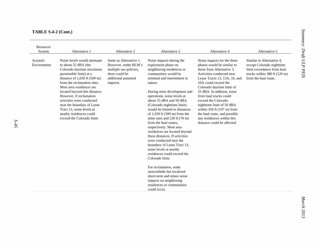
Summ
ary: Draft U
LP
PE
IS
March 2013
S-45
TABLE S.4-2 (Cont.)
Resource/
System
Alternative 1 Alternative 2 Alternative 3 Alternative 4 Alternative 5 Acoustic Environment
Noise levels would attenuate to about 55 dBA (the Colorado daytime maximum permissible limit) at a distance of 1,650 ft (500 m) from the reclamation sites. Most area residences are located beyond this distance. However, if reclamation activities were conducted near the boundary of Lease Tract 13, noise levels at nearby residences could exceed the Colorado limit.
Same as Alternative 1. However, under BLM’s multiple use policies, there could be additional potential impacts.
Noise impacts during the exploration phase on neighboring residences or communities would be minimal and intermittent in nature. During mine development and operations, noise levels at about 55 dBA and 50 dBA (Colorado nighttime limit) would be limited to distances of 1,650 ft (500 m) from the mine sites and 230 ft (70 m) from the haul routes, respectively. Most area residences are located beyond these distances. If activities were conducted near the boundary of Lease Tract 13, noise levels at nearby residences could exceed the Colorado limit. For reclamation, some unavoidable but localized short-term and minor noise impacts on neighboring residences or communities could occur.
Noise impacts for the three phases would be similar to those from Alternative 3. Activities conducted near Lease Tracts 13, 13A, 16, and 16A could exceed the Colorado daytime limit of 55 dBA. In addition, noise from haul trucks could exceed the Colorado nighttime limit of 50 dBA within 350 ft (107 m) from the haul route, and possibly any residences within this distance could be affected.
Similar to Alternative 4, except Colorado nighttime limit exceedance from haul trucks within 380 ft (120 m) from the haul route.

Summ
ary: Draft U
LP
PE
IS
March 2013
S-46
TABLE S.4-2 (Cont.)
Resource/
System
Alternative 1 Alternative 2 Alternative 3 Alternative 4 Alternative 5 Soil Resources Ground disturbances from
reclamation activities could result in minor impacts due to soil compaction, soil horizon mixing, soil contamination (from oil and fuel releases related to use of trucks and other equipment), and soil erosion.
Same as Alternative 1. However, under BLM’s multiple use policies, there could be additional potential impacts.
Ground disturbances from mining-related activities could result in minor impacts due to soil compaction, soil horizon mixing, soil contamination (from oil and fuel releases related to use of trucks and other equipment), and soil erosion. Potential impacts from Alternative 3 would likely be greater than those from Alternative 1 since there would be impacts from mine development and operations, which would also be conducted.
Potential impact could be greater than that from Alternative 3 since more mines would be developed and operated.
Potential impact could be slightly greater than from Alternative 4 since larger sized mines would be developed requiring a slightly larger surface footprint.
1 2 3 4

Summ
ary: Draft U
LP
PE
IS
March 2013
S-47
TABLE S.4-3 Comparison of the Potential Impacts on Water Resources, Land Use, and Waste Management from Alternatives 1 1 through 5 2
Resource/
System
Alternative 1 Alternative 2 Alternative 3 Alternative 4 Alternative 5
Water Resources
Of the 10 lease tracts evaluated for Alternative 1, reclamation activities on Lease Tract 13 has the greatest potential to affect surface water resources due to the proximity to the Dolores River. The potential impacts due to the backfill materials and poor sealing of drill holes would be minor in Lease Tracts 7, 9, and 13 and avoided by implementation of reclamation performance standards set by the CDWR.
Same as Alternative 1. However, under BLM’s multiple use policies, there could be additional potential impacts.
Potential impacts (e.g., runoff generation and erosion) associated with exploration would be minor due to the small amount of land involved. Potential impacts of groundwater mixing and leaching via exploratory drill holes are expected to be minor in a few lease tracts (i.e., Lease Tracts 7, 9, and 13). For mine development and operations, activities on lease tracts closest to the Dolores River and San Miguel River (e.g., Lease Tracts 13 and 18) pose the greatest potential to affect water quality because of erosion. Potential groundwater contamination impacts and dewatering effects would be minor in a few lease tracts (i.e., Lease Tracts 7, 9, and 13). However, a limited number of existing domestic water wells, associated with Lease Tracts 7, 9, and 13, would be potentially affected if local groundwater is contaminated or aquifers are dewatered. Impacts from reclamation activities would be greater than those for Alternative 1. Water use under Alternative 3 during development and operation would be 3,200,000 gal/yr (9.8 ac-ft/yr).
Similar to the type of potential impacts under Alternative 3, potential impacts associated with exploration (e.g., runoff generation and erosion) would be minor due to the small spatial extent involved. Potential impacts of groundwater mixing and leaching via exploratory drill holes are expected to be minor in a few lease tracts (i.e., Lease Tracts 7, 9, and 13). Also, mine development and operations on the lease tracts closest to the Dolores River and San Miguel River (i.e., Lease Tracts 13 and 18) would have the greatest potential to affect water quality because of erosion. Potential groundwater contamination impacts and dewatering effects would be minor in a few lease tracts (i.e., Lease Tracts 7, 9, 13, and possibly 8A). The number of domestic wells that might be affected is similar to Alternative 3, and they are associated more with Lease Tracts 5, 6, 8, 13, 16, and 18. Impacts from reclamation activities would be greater than those under Alternative 1. Water use under Alternative 4 during development and operation would be two times higher than that under Alternative 3.
Similar to Alternative 4, except water that would be used during development and operation is 8,000,000 gal/yr (25 ac-ft/yr).

Summ
ary: Draft U
LP
PE
IS
March 2013
S-48
TABLE S.4-3 (Cont.)
Resource/
System
Alternative 1 Alternative 2 Alternative 3 Alternative 4 Alternative 5 Land Use Potential impacts due to land
use conflicts are expected to be small under Alternative 1; the lands would continue to be closed to mineral entry, and all other activities, like recreation within the lease tracts, would continue.
Same as Alternative 1. However, under BLM’s multiple use policies, there could be additional potential impacts.
Potential impacts due to land use conflicts are expected to be minor under Alternative 3; the lands would be closed to mineral entry, and all other activities, like recreation within the lease tracts, would continue.
Potential impacts due to land use conflicts are expected to be small under Alternative 4; the lands would continue to be closed to mineral entry, and all other activities, like recreation within the lease tracts, would continue.
Potential impacts due to land use conflicts are expected to be small like Alternative 4 but would affect a slightly larger amount of land due to larger sized mines that would be developed.
Waste Management
Amounts of waste or trash generated would be small and would be taken to a mill for recovery, or taken to a permitted landfill near Nucla or Naturita.
Same as Alternative 1. However, under BLM’s multiple use policies, there could be additional potential impacts.
Amounts of waste that would be generated during exploration, mine development and operations, and reclamation would be small and managed in a manner similar to that described for Alternative 1. Any waste-rock piles that would remain at the mine surface would be graded to be consistent with the surrounding area, provided with a top cover of soil or other material from the mine site, and seeded.
Amounts of waste or trash generated during the three phases would be small but more than those generated under Alternative 3. They would be managed in a manner similar to that described for Alternatives 1 and 3.
Amount of waste or trash generated during the three phases would be small but slightly more than that generated under Alternative 4.
1
2

Summ
ary: Draft U
LP
PE
IS
March 2013
S-49
TABLE S.4-4 Comparison of the Potential Impacts on Human Health from Alternatives 1 through 5 1
Phase of Activities Receptor Assessment Endpointa Alternative 1 Alternative 2 Alternative 3 Alternative 4 Alternative 5
Mine development and operations
Uranium miner Individual rad dose (mrem/yr) NAb NA 433c Same as Alt. 3 Same as Alt. 3 Individual LCF risk (1/yr) NA NA 4 × 10⁻⁴ c Same as Alt. 3 Same as Alt. 3 Chemical risk (hazard index or HI) NA NA 1.1d Same as Alt. 3 Same as Alt. 3
General public – resident
Individual rad dose (mrem/yr) NA NA 16‒1.9e
(WL: 0.0013 to 0.00016)
Same as Alt. 3 Same as Alt. 3
Individual LCF risk (1/yr) NA NA 2 × 10⁻⁵ to3 × 10–6 e
Same as Alt. 3 Same as Alt. 3
Collective rad dose (person-rem/yr) NA NA 7.5 to39f 17‒94f 20‒110f Collective LCF (1/yr) NA NA 0.01 to0.05f 0.02‒0.1f 0.03‒0.1f Chemical risk (HI) NA NA << 1.0e Same as Alt. 3 Same as Alt. 3
Reclamation Reclamation
worker Individual rad dose (mrem/yr) 4.8
(WL: <5 × 10⁻⁵)Same as Alt. 1 Same as Alt. 1 Same as Alt. 1 Same as Alt. 1
Individual LCF risk (1/yr) 4 10–6 Same as Alt. 1 Same as Alt. 1 Same as Alt. 1 Same as Alt. 1 Chemical risk (HI) 0.043 Same as Alt. 1 Same as Alt. 1 Same as Alt. 1 Same as Alt. 1
General public – resident
Individual rad dose (mrem/yr) 3.0‒0.03g
(WL: <2 × 10⁻⁴)Same as Alt. 1 Same as Alt. 1 Same as Alt. 1 Same as Alt. 1
Individual LCF risk (1/yr) 3 10–6 to3 10–8 g
Same as Alt. 1 Same as Alt. 1 Same as Alt. 1 Same as Alt. 1
Chemical risk (HI) < 0.010 Same as Alt. 1 Same as Alt. 1 Same as Alt. 1 Same as Alt. 1

Summ
ary: Draft U
LP
PE
IS
March 2013
S-50
TABLE S.4-4 (Cont.)
Phase of Activities Receptor Assessment Endpointa Alternative 1 Alternative 2 Alternative 3 Alternative 4 Alternative 5
Post-reclamation General public –
recreationist Individual rad dose (mrem/yr) 0.38 to 11h
(WL: <2 × 10⁻⁴)
Same as Alt. 1 Same as Alt. 1 Same as Alt. 1 Same as Alt. 1
Individual LCF risk (1/yr) 7 10–7 to 9 10–6
Same as Alt. 1 Same as Alt. 1 Same as Alt. 1 Same as Alt. 1
Chemical risk (HI) < 0.13 Same as Alt. 1 Same as Alt. 1 Same as Alt. 1 Same as Alt. 1
General public – individual entering an inactive underground mine
Individual rad dose (mrem/h) 7.4 to 87i
(WL: 3 to 39) Same as Alt. 1 Same as Alt. 1 Same as Alt. 1 Same as Alt. 1
Individual LCF risk (1/h) 9 10–6 to 3 10–4i
Same as Alt. 1 Same as Alt. 1 Same as Alt. 1 Same as Alt. 1
Chemical risk (HI) 0 Same as Alt. 1 Same as Alt. 1 Same as Alt. 1 Same as Alt. 1
a Radiation dose and chemical risk (HI) estimates are rounded to two significant figures; latent cancer facility (LCF) risk is rounded to one significant figure.
For some radiation doses, the corresponding radon levels in terms of working level (WL) are also listed in parentheses.
b NA = not applicable; continued uranium mining would not occur under Alternatives 1 and 2.
c The listed values are based on historical data on the average exposures of underground uranium miners.
d The impact associated with exposure to particulates containing uranium and vanadium compounds during this phase was estimated based on the radiation dose associated with inhalation of particulates containing uranium isotopes and their decay products.
e Potential individual radiation dose and LCF risk for the general public – resident scenario would depend on the location of the residence. The dose and risk are functions of the distance and direction from the residence to the radon emission source. The listed range is associated with a residence located in the dominant wind direction that gives the highest exposures at a distance of 1,630 to 16,400 ft (500 to 5,000 m) to the emission source, which is a medium-underground mine. Potential dose and LCF risk associated with a small underground mine would be about half of the listed values; those associated with a large underground mine would be about twice the listed values. Potential dose and LCF risk associated with a very large open-pit mine would be greater than those associated with a small underground mine but less than those associated with a medium-sized underground mine for a distance of 3,300 ft (1,000 m) or greater. Potential hazard index associated with the exposures of residents is expected to be much smaller than that associated with the exposures of uranium miners (i.e., much smaller than the threshold value of 1).
Footnotes continued on next page.

Summ
ary: Draft U
LP
PE
IS
March 2013
S-51
TABLE S.4-4 (Cont.)
f The collective dose and LCF risk were estimated for the entire population living at a distance of 3.1 to 50 mi (5 to 80 km) from the center of each lease
tract group. The collective dose and LCF risk correspond to the peak year of operations. In any other year, the collective dose/LCF risk is expected to be lower than the listed value.
g Potential individual radiation dose and LCF risk for the general public – resident scenario would depend on the location of the residence. The dose and risk are functions of the distance and direction from the residence to the source of radon and particulate emissions. The listed range is associated with a residence located in the most dominant wind direction at a distance of 1,600 to 16,000 ft (500 to 5,000 m) to the emission source, which is a waste-rock pile at a scale ranging from small to very large. The waste-rock pile is assumed to be generated by the development and operations of an underground mine for 10 years.
h The recreationist dose and LCF risk results were obtained based on the assumption that the emission source (i.e., a waste-rock pile) would be covered by 0–1 ft (0–0.3 m) of soil materials.
i Potential individual radiation dose and LCF risk for the general public – individual entering an inactive underground mine were calculated on the basis of radon levels that were measured in three abandoned mines in the United Kingdom (Denman et al. 2003).
1 2 3

Summ
ary: Draft U
LP
PE
IS
March 2013
S-52
TABLE S.4-5 Comparison of the Potential Impacts on Ecological Resources from Alternatives 1 through 5 3
Resource/
System
Alternative 1 Alternative 2 Alternative 3 Alternative 4 Alternative 5 Vegetation It is expected that impacts under
Alternative 1 would generally be minor and short term. Areas affected by Alternative 1 activities would generally consist of previously disturbed areas, and reclamation would generally include relatively small surface areas (approximately 1 to 8 acres [0.4 to 3.2 ha] per mine, other than the JD-7 mine). Reclamation would establish plant communities on disturbed areas, including waste rock; however, resulting plant communities might be considerably different from those of adjacent areas. The successful reestablishment of some plant communities, such as sagebrush shrubland or piñon-juniper woodland, would likely require decades. Indirect impacts associated with reclamation activities could include the deposition of fugitive dust, erosion, sedimentation, and the introduction of non-native species, including noxious weeds. However, because of the small areas involved and short duration of reclamation activities, these would generally constitute a short-term impact. The establishment of invasive species, including the potential alteration of fire regimes, could result in long-term impacts, although monitoring and vegetation management programs would likely control invasive species.
Same as Alternative 1. However, under BLM’s multiple use policies, there could be additional potential impacts.
Impacts under Alternative 3 would range from minor to moderate and short term to long term. Impacts from exploration would result from disturbance of vegetation and soils, the removal of trees or shrubs, compaction of soils, destruction of plants, burial of vegetation under waste material, or erosion and sedimentation. Exploration activities are expected to affect relatively small areas, and impacts would generally be short term. The localized destruction of biological soil crusts, where present, would be considered a longer-term impact, particularly where soil erosion has occurred. Ground disturbance from mine development and operations would range from 10 to 20 acres (4 to 8 ha) per mine, except for the 210-acre (85-ha) JD-7 open-pit mine. Impacts would include the destruction of habitats during site clearing and excavation, as well as the loss of habitat in additional use areas. Affected areas might include high-quality mature habitats or previously degraded areas. Wetlands present on project sites could be directly or indirectly affected. Indirect impacts from mining would be associated with fugitive dust, invasive species, erosion, sedimentation, and impacts due to changes in surface water or groundwater hydrology or water quality. The deposition of fugitive dust and the establishment of invasive species, including the potential alteration of fire regimes, could result in long-term impacts.
Impacts would be similar to those for Alternative 3, except a larger area (460 acres, or 190 ha) would be disturbed.
Similar to Alternative 4 with respect to the amount of area disturbed, but disturbance would be for a shorter period of time (i.e., 10 years versus potentially more than 10 years for Alternative 4).

Summ
ary: Draft U
LP
PE
IS
March 2013
S-53
1 TABLE S.4-5 (Cont.)
Resource/
System
Alternative 1 Alternative 2 Alternative 3 Alternative 4 Alternative 5 Wildlife Reclamation activities would cause a
short-term, localized disturbance of wildlife in the area of the 13 mine sites on 10 lease tracts. Reclamation of 267 acres (108 ha) would result in long-term, localized improvement of wildlife habitats within the 10 lease tracts. Negligible impacts on wildlife would occur during DOE’s long-term management of the withdrawn lands.
Similar to Alternative 1. However, under BLM’s multiple use policies, there could be additional potential impacts.
There could be impacts on a total of 310 acres (125 ha) of wildlife habitat at 8 mine sites within 1 or more of the 12 formerly active lease tracts during the peak year of operations. Additional habitats could be affected by any access roads or utility lines required for the mines. Impacts on wildlife could occur from habitat disturbance, wildlife disturbance, and wildlife injury or mortality and habitat loss. Overall, localized impacts on wildlife would range from negligible to moderate during mine development and operations, while wildlife impacts would last for decades but would not affect the viability of wildlife populations.
Impacts would be similar to those from Alternative 3, except that a total of 460 acres (190 ha) of wildlife habitat at 19 mine sites could be disturbed within any of the 31 lease tracts during the peak year of operations. Overall, localized impacts on wildlife would range from negligible to moderate and would not affect the viability of wildlife populations.
Impacts on a total of 490 acres (198 ha) of wildlife habitat at 19 mine sites within any of the 31 lease tracts during the peak year of operations. Impacts on wildlife would be similar to, but for a shorter time period than, those for Alternative 4. Overall, localized impacts on wildlife would range from negligible to moderate and would not affect the viability of wildlife populations.
Aquatic Biota Reclamation activities could cause
sediment deposition in intermittent and ephemeral streams and possibly the Dolores River. The potential for sediments to enter the perennial streams is negligible to minor due to the limited amount of land undergoing reclamation in any given area. Reclaimed areas would be less prone to erosion as vegetation becomes established.
Similar to Alternative 1. However, under BLM’s multiple use policies, there could be additional potential impacts.
Impacts on aquatic resources could result from increases in sedimentation and turbidity from soil erosion and runoff during mine development and operations. There would be a very low likelihood of an accidental ore spill into a perennial stream or river. Overall, localized impacts on aquatic biota would range from negligible to moderate and would not affect the viability of any aquatic species.
Impacts on aquatic resources would be similar to those under Alternative 3, except that 19 mines could be in operation on any of the 31 lease tracts during the peak year of operations. Overall, localized impacts on aquatic biota would range from negligible to moderate and would not affect the viability of any aquatic species
Impacts on aquatic resources would be similar to those under Alternative 4, except that the mines would be in operation for a shorter length of time. Overall, localized impacts on aquatic biota would range from negligible to moderate and would not affect the viability of any aquatic species.

Summ
ary: Draft U
LP
PE
IS
March 2013
S-54
TABLE S.4-5 (Cont.)
Resource/
System
Alternative 1 Alternative 2 Alternative 3 Alternative 4 Alternative 5 Threatened, Endangered, and Sensitive Species
Reclamation activities would generally cause minor, short-term impacts on threatened, endangered, and sensitive species. The small scale of reclamation activities on previously disturbed areas would generally have minor direct impacts on sensitive terrestrial species. Indirect impacts associated with water withdrawal, erosion, and sedimentation might have minor, short-term impacts on sensitive aquatic species (including Colorado River endangered fish species).
Same as Alternative 1. However, under BLM’s multiple use policies, there could be additional potential impacts.
Potential impacts on threatened, endangered, and sensitive species could range from small to moderate and short term to long term, depending on the location of the mines and amount of surface disturbance. Direct impacts could result from the destruction of habitats during site clearing, excavation, and operations. Indirect impacts could result from fugitive dust, erosion, sedimentation, and impacts related to altered surface water and groundwater hydrology. Water withdrawals from the Upper Colorado River Basin to support mining activities may result in potentially unavoidable impacts on aquatic biota (particularly the Colorado River endangered fish species). For this reason, ULP activities under Alternative 3 may affect, but are not likely to adversely affect, the Colorado River endangered fish species and their critical habitat.
Similar to Alternative 3. However, there would be more lease tracts available for mining under this alternative, thereby increasing the area that could be disturbed or developed and the potential for impacts on threatened, endangered, and sensitive species.
Similar to Alternative 4, but the total disturbed surface area is somewhat larger than that under Alternative 4.
2 3 4 5
6 7

Summ
ary: Draft U
LP
PE
IS
March 2013
S-55
TABLE S.4-6 Comparison of the Potential Impacts on Socioeconomics, Environmental Justice, and Transportation from Alternatives 1 1 through 5 2
Resource/
System
Alternative 1 Alternative 2 Alternative 3 Alternative 4 Alternative 5 Socioeconomics Potential impact is
expected to be minor. Reclamation activities would require 29 direct jobs and generate 16 indirect jobs. Reclamation would produce $1.7 million in income. There would likely be a small positive impact on recreation and tourism because of the reclamation that would be completed.
Same as Alternative 1. However, under BLM’s multiple use policies, there could be additional potential impacts.
Potential impact is expected to be minor. Mine development and operations would create 123 direct jobs, 98 indirect jobs, $4.7 million in direct income, and $4.0 million in indirect income. In-migration could include up to 63 people moving into the ROI. Reclamation activities would require 29 direct jobs and generate 17 indirect jobs. Reclamation would produce $1.8 million in income.
Potential impact is expected to be minor. Mine development and operations would create 229 direct jobs, 152 indirect jobs, and $14.8 million in income. In-migration could include up to 115 people moving into the ROI. Reclamation activities would require 39 direct jobs and generate 21 indirect jobs. Reclamation would produce $2.4 million in income.
Potential impact is expected to be minor. Mine development and operations would create 253 direct jobs, 152 indirect jobs, and $15.6 million in income. In-migration could include up to 122 people moving into the ROI. Reclamation activities would require 39 direct jobs and generate 25 indirect jobs. Reclamation would produce $2.5 million in income.
Environmental Justice
Potential impacts on the general population could result from uranium mining activities. For the majority of resources evaluated, impacts would be likely to be minor and would be unlikely to disproportionately affect low-income and minority populations.
Same as Alternative 1. However, under BLM’s multiple use policies, there could be additional potential impacts.
Potential impacts are likely to be minor and are unlikely to disproportionately affect low-income and minority populations. Specific impacts on low-income and minority populations as a result of participation in subsistence or cultural and religious activities would also be minor and unlikely to be disproportionate.
The types of impacts related to mine development and operations under Alternative 4 would be similar to those described under Alternative 3, but the increase in the disturbed area under Alternative 4 could potentially increase the impacts. Impacts on low-income and minority populations associated with the reclamation activities would be the same as those under Alternative 1.
The types of impacts related to exploration under Alternative 5 would be similar to those under Alternative 3. The types of impacts related to mine development and operations under Alternative 5 would be similar to those under Alternative 4. Under Alternative 5, for the majority of resources evaluated, the impacts would likely be minor and would be unlikely to have disproportionate impacts on low-income or minority populations.

Summ
ary: Draft U
LP
PE
IS
March 2013
S-56
TABLE S.4-6 (Cont.)
Resource/
System
Alternative 1 Alternative 2 Alternative 3 Alternative 4 Alternative 5 Transportation No transportation of
uranium ore would occur. There would be no radiological transportation impacts. No changes in current traffic trends near the DOE ULP lease tracts would be anticipated because no significant supporting truck traffic or equipment moves would occur, and only about five reclamation workers would be commuting to each site on a regular basis during reclamation activities.
Same as Alternative 1. However, under BLM’s multiple use policies, there could be additional potential impacts.
There would be an average of approximately 40 round-trip uranium ore truck shipments per weekday under Alternative 3. For the sample case considered, the total annual distance travelled in the peak year by the haul trucks would be about 1.10 million mi (1.77 million km), primarily on CO 90 and CO 141 and on US 491 and US 191. The estimated attendant traffic accident injuries and fatalities would be about 0.33 and 0.029, respectively. The resultant collective radiological population dose to those individuals living and working near the haul routes was estimated to be approximately 0.14 person-rem, a dose that could potentially result in an LCF risk of 8 10–5. The potential annual collective dose estimated for the truck drivers is 0.71 person-rem, with an associated LCF risk of 0.0004. Dependent on which lease tracts have mining operations and which mill was used in each case, the total annual distance in the peak year could range from about 0.47 million to 2.22 million mi (751,000 to 3.58 million km), with impacts roughly proportional to the distance travelled.
There would be an average of approximately 80 round-trip uranium ore truck shipments per weekday under Alternative 4. For the sample case considered, the total annual distance travelled in the peak year by the haul trucks would be about 2.22 million mi (3.57 million km), primarily on CO 90 and CO 141 and on US 491 and US 191. The estimated attendant traffic accident injuries and fatalities would be about 0.63 and 0.057, respectively. The resultant collective radiological population dose to those individuals living and working near the haul routes was estimated to be approximately 0.28 person-rem, a dose that could potentially result in an LCF risk of 0.0002 in the population. The potential annual collective dose estimated for the truck drivers is 1.4 person-rem, with an associated LCF risk of 0.0009. Dependent on which lease tracts have mining operations and which mill was used in each case, the total annual distance in the peak year could range from about 1.14 million to 4.26 million mi (1.84 million to 6.86 million km), with impacts roughly proportional to the distance travelled.
There would be an average of approximately 92 round-trip uranium ore truck shipments per weekday under Alternative 5. For the sample case considered, the total annual distance travelled in the peak year by the haul trucks would be about 2.72 million mi (4.38 million km), primarily on CO 90 and CO 141 and on US 491 and US 191. The estimated attendant traffic accident injuries and fatalities would be about 0.81 and 0.073, respectively. The resultant collective radiological population dose to those individuals living and working near the haul routes is estimated to be approximately 0.34 person-rem, a dose that could potentially result in an LCF risk of 0.0002 in the population. The potential annual collective dose estimated for the truck drivers was 1.8 person-rem, with an associated LCF risk of 0.001. Depending on which lease tracts have mining operations and which mill was used in each case, the total annual distance in the peak year could range from about 1.45 million to 4.90 million mi (2.34 million to 7.88 million km), with impacts roughly proportional to the distance travelled.
1 2

Summ
ary: Draft U
LP
PE
IS
March 2013
S-57
TABLE S.4-7 Comparison of the Potential Impacts on Cultural Resources and Visual Resources from Alternatives 1 through 5 3
Resource/
System
Alternative 1 Alternative 2 Alternative 3 Alternative 4 Alternative 5 Cultural Resources
Under Alternative 1, indirect impacts could occur on all known cultural resources located within the 10 lease tracts. It is estimated that there are 111 resources within the 10 lease tracts. Direct impacts are not expected because areas to be reclaimed have already been disturbed, and no new land disturbance is expected. Indirect impacts under Alternative 1 would include the increased potential for vandalism related to road or footpath expansion and for the disturbance of a cultural resource from fugitive dust. Significant cultural properties that could be adversely affected by the proposed action would be identified before any ground-disturbing activities occurred, and plans would be modified to avoid or mitigate impacts on cultural resources. There is potential for buried cultural deposits to be uncovered even if sites were not identified on the surface prior to ground disturbance activities.
Same as Alternative 1. However, under BLM’s multiple use policies, there could be additional potential impacts.
Under Alternative 3, indirect impacts could occur on all known cultural resource sites located within the 12 lease tracts. It is estimated that there are 128 resources within the 12 lease tracts. Direct impacts could occur on eight of these resources. Potential direct impacts would include the disturbance of buried cultural resources or surface deposits as a result of excavation, vibration from equipment, and fugitive dust. Indirect impacts would include visual disturbance to resources; the introduction of noise to traditional sacred areas; and an increased potential for vandalism, erosion, trampling, and nonauthorized collecting related to road or footpath expansion. Significant cultural properties that would be adversely affected by the proposed actions would be identified before any ground-disturbing activities occurred, and plans would be modified to avoid or mitigate impacts on cultural resources.
Under Alternative 4, indirect impacts on all known cultural resources located within the 31 lease tract could occur. Direct impacts could occur on 21 of these resources. Types of potential impacts would be the same as those discussed for Alternative 3. Significant cultural properties that would be adversely affected by the proposed action would be identified before ground-disturbing activities occurred, and plans could be modified to avoid or mitigate impacts on cultural resources.
Similar to Alternative 4, except that direct impacts could occur on 23 of the known cultural resources on the 31 lease tracts.

Summ
ary: Draft U
LP
PE
IS
March 2013
S-58
TABLE S.4-7 (Cont.)
Resource/
System
Alternative 1 Alternative 2 Alternative 3 Alternative 4 Alternative 5 Visual Resourcesa
Potential visual impacts that could occur under Alternative 1 would include vegetation clearing, landform alteration, removal of structures and materials, changes to existing roadways, vehicular and worker activity, and light pollution. Under Alternative 1, one or more of the 10 lease tracts would be visible from portions of the Sewemup WSA, Palisade ONA ACEC, Palisade WSA, Unaweep/ Tabeguache Scenic and Historic Byway, Tabeguache Area, Dolores River Canyon WSA, Dolores River SRMA, McKenna Peak WSA, San Miguel ACEC, San Miguel SMRA, and Trail of the Ancient Byways, which are located within 0–25 mi (0–40 km) of the lease tracts. Visual contrast of visible activities occurring within the lease tracts would range from none to strong, depending on the viewer’s location with respect to the SVRA.
Similar to Alternative 1. However, under BLM’s multiple use policies, there could be additional potential impacts.
Potential visual impacts that could occur under Alternative 3 include vegetation clearing, exploratory drilling, road construction, support facility construction, worker and equipment presence, and lighting in the form of skyglow, light trespass, or glare. Under Alternative 3, one or more of the 12 lease tracts would be visible from portions of the Sewemup WSA, Unaweep/Tabeguache Scenic and Historic Byway, Tabeguache Area, Dolores River Canyon WSA, Dolores River SRMA, McKenna Peak WSA, San Miguel ACEC, San Miguel SMRA, and Trail of the Ancient Byways, which are located within 0–25 mi (0–40 km) of the lease tracts. Visual contrast of visible activities occurring within the lease tracts would range from none to strong, depending on the viewer’s location with respect to the SVRA.
Potential visual impacts under Alternative 4 would be the same as those under Alternative 3.
Under Alternative 4, 1 or more of the 31 lease tracts would be visible from portions of the Sewemup, Palisade, Squaw/Papoose Canyon, McKenna Peak, Dolores River Canyon, and Cahone Canyon WSAs; the Palisade ONA, San Miguel SMRA, and San Miguel ACECs; the Unaweep/ Tabeguache Scenic and Historic Byway; the Tabeguache Area; the Dolores River SRMA; Canyon of the Ancients National Monument; and Trail of the Ancient Byways, which are located within 0–25 mi (0–40 km) of the lease tracts. Visual contrast of visible activities occurring within the 31 lease tracts would range from none to strong, depending on the viewer’s location with respect to the SVRA.
Similar to Alternative 4.
a ONA = Outstanding Natural Area, SRMA = Special Recreation Management Area, SVRA = special visual resource area, WA = Wilderness Area, WSA = Wilderness
Study Area.

Summary: Draft ULP PEIS March 2013
S-59
S.5 MEASURES TO MINIMIZE POTENTIAL IMPACTS FROM ULP MINING 4 ACTIVITIES 5
6 The potential impacts discussed in Tables S.4-2 through S.4-7 are expected to be 7 minimized or reduced by implementing the measures listed in Table S.5-1. These measures apply 8 to the three phases of the proposed action (exploration, mine development and operations, and 9 reclamation), as applicable. The measures have been grouped by the 12 objectives included in 10 Table S.5-1 and further categorized into the following three categories: 11 12 13
1. Compliance measures: Measures that are required by applicable regulations. 14 15
2. Mitigation measures: Measures that are required by DOE as identified in 16 current leases or that could be added to the leases when modified. DOE may 17 also identify additional mitigation measures. 18
19 3. Best management practices (BMPs): Best industry practices and activities that 20
should be considered during implementation, as practicable. 21 22 Reclamation activities would be conducted to ensure that post-reclamation mine 23 conditions are protective of the environment and human health. Mitigation measures such as 24 those listed in Table S.5-1 would be implemented so that potential exposure to a reasonable end-25 state scenario (i.e., a recreational visitor scenario at the mine site footprint and within the lease 26 tracts, and a resident scenario for outside the lease tracts) would be at acceptable risk levels 27 (e.g., meet applicable dose requirements or the EPA’s acceptable risk range) for the appropriate 28 end-state land use. 29 30 Specifics associated with the measures (compliance, mitigation measures, or BMPs) that 31 involve monitoring, sample collection, and the installation of protective elements (e.g., depth of 32 soil cover on waste-rock piles, the necessity for and/or type of liners for water evaporation 33 ponds, other elements) during operations and reclamation would be identified in the mine plans 34 submitted to DOE for review and approval. 35 36 37 38 39

Summ
ary: Draft U
LP
PE
IS
March 2013
S-60
TABLE S.5-1 Measures Identified to Minimize Potential Impacts from Uranium Mining at the ULP Lease Tracts 1
Measure Description Compliance
Measurea
Mitigation Measureb BMPc
M-1 Reduce dust emissions; reduce air emissions • Apply water or chemical suppressants on unpaved haul roads, disturbed surfaces, and temporary stockpiles. X • Limit soil-disturbing activities and travel on unpaved roads. Xd • Design and construct new access roads to meet appropriate standards; roads should be no larger than
necessary to accommodate their intended function. Xd
• Cover unpaved access roads, frequently used on-site roads, and parking lots with aggregate. X • Assure all heavy equipment meets emission standards as required. X • Limit idle time of vehicles and motorized equipment. X • Fuel all diesel engines used with ultra-low sulfur diesel (sulfur content of ≤15 parts per million [ppm]). Xe • Avoid construction traffic and reduce speeds on unpaved surfaces. X • Ensure that all vehicles transporting loose materials are covered (e.g., with tarpaulins), both when travelling
with a load of ore and when returning empty; loads should be sufficiently wet and kept below the freeboard. X
M-2 Identify and protect paleontological resources • Consult with affected BLM Field Offices to determine whether areas of moderate to high fossil-yield
potential (i.e., PFYC 3, 4, or 5) or known significant localities occur within proposed areas of disturbance. All PFYC 4 and 5 areas should be field surveyed; PFYC 3 areas should be field surveyed and sampled. Surveys should be conducted along rock outcrops devoid of thick soils and well-developed vegetation to identify exposed fossils. Areas identified as PFYC 3, 4, or 5 may require monitoring by a qualified paleontologist during all excavation and earthmoving activities.
X
• For areas of high fossil-yield potential (PFYC 4 or 5), develop a paleontological resources management plan to define mitigation measures (i.e., avoidance, removal, monitoring, or special stipulations) and the analysis, reporting, and curation of any collected fossils.
X
• Immediately notify the BLM authorized officer of any paleontological resources discovered as a result of mining activities so that appropriate measures to mitigate adverse effects to significant paleontological resources can be determined and implemented. Operations may continue if activities can avoid further impacts on the fossil discovery or can be continued elsewhere.
X
2

Summ
ary: Draft U
LP
PE
IS
March 2013
S-61
TABLE S.5-1 (Cont.)
Measure Description Compliance
Measurea
Mitigation Measureb BMPc
M-3 Reduce noise-related impacts • Maintain equipment in good working order in accordance with manufacturer’s specifications. X • Limit noisy activities to the least noise-sensitive times of the day (daytime between 7 a.m. and 7 p.m.) and
weekdays and limit idle time for vehicles and motorized equipment. X
• Notify area residents of high-noise and/or high-vibration-generating activities (e.g., aboveground and belowground blasting) in advance.
X
• Employ noise-reduction devices (e.g., mufflers) as appropriate. X • Provide a noise complaint process for surrounding communities. X • Site noise sources to take advantage of topography and distance; construct engineered sound barriers and/or
berms as necessary. X
• Limit operational noise to 49 dBA or less within 2 mi (3 km) from an occupied/active Gunnison sage-grouse lek.
X
M-4 Protect soils from erosion; protect local surface water bodies from contamination and sedimentation;
protect local aquifers from contamination
• Identify local factors that cause slope instability (e.g., slope angles, precipitation) and avoid areas with
unstable slopes. X
• Avoid creating excessive slopes during excavation; use special construction techniques, where applicable, in areas of steep slopes, erodible soil, and stream channel crossings.
Xf
• Apply all dust palliatives in accordance with appropriate laws and regulations; ensure that dust suppression chemicals are not sprayed on (released to) soils or streams.
Xg
• Control and direct runoff from slope tops to settling or rapid infiltration basins until disturbed slopes are stabilized; stabilize slopes as quickly as possible.
Xh
• Assure operators comply with CDRMS requirements regarding groundwater and groundwater contamination.
X
• Obtain borrow materials from authorized or permitted sites. Xi • Retain sediment-laden waters from disturbed areas with the lease tract through the use of barriers and
sedimentation devices (e.g., berms, straw bales, sandbags, jute netting, or silt fences) as necessary. Xh
• Place barriers and sedimentation devices around drainages and wetlands. Xg • Require developers using on-site groundwater supplies to conduct a hydrologic study consistent with that
required by the state’s environmental protection plan. X

Summ
ary: Draft U
LP
PE
IS
March 2013
S-62
TABLE S.5-1 (Cont.)
Measure Description Compliance
Measurea
Mitigation Measureb BMPc
• Conduct routine inspections to assess effectiveness and maintenance requirements for erosion and sediment
control systems. X
• Maintain, repair, or replace barriers and sedimentation devices as necessary to ensure optimum control. Xh • Inspect and clean tires of all vehicles to ensure they are free of dirt before they enter paved public roadways
to the extent practicable. X
• Locate a diversion ditch upstream of the mine site to intercept surface water flow or shallow groundwater and channel it around the site; tailor the location and length of the ditch to site-specific conditions, taking into account the location of mine waste piles, the site topography, and surface flow patterns.
Xh
• Place drill holes at a distance from existing water rights to the extent possible. X • Plug open drill holes and areas around vent shafts to reduce the volume of groundwater entering an
underground mine during operations to the extent possible; use underground sumps to contain water flow, as needed; pump water from groundwater seepage to control water flow, if necessary, into surface mine-water treatment pond.
Xj
• Divert water pumped from mines (or drill sites) to a lined sedimentation pond for treatment. Locate settling pond(s) in topographically low areas (but not any that are along drainages or near naturally flowing water). The purpose of treatment is to promote the precipitation of heavy metals through oxidation processes like aeration. (Employ this option at sites at which the mine drainage is high in total suspended solids).
Xh
• As sedimentation ponds are cleaned, test sediments and precipitates for proper disposal. Xh • Locate mine ore storage and waste-rock or tailings piles on topographically high ground so they do not
come into direct contact with flowing or ponded water; grade the ore storage area and construct an earthen berm around it. Divert any runoff from the area to a sedimentation pond for testing and treatment.
X
• Contain any runoff from mine waste-rock piles (e.g., divert it to a sedimentation pond) and treat it, as needed.
Xh
• Provide off-site (downgradient) groundwater monitoring consistent with Colorado requirements for groundwater protection permits.
Xi
• Site and design mine entrances and activities so that they avoid direct and indirect impacts on important, sensitive, or unique habitats, including, but not limited to, wetlands (both jurisdictional and nonjurisdictional), springs, seeps, streams (ephemeral, intermittent, and perennial), 100-year floodplains, ponds and other aquatic habitats, riparian habitats, remnant vegetation associations, rare or unique biological communities, crucial wildlife habitats, and habitats supporting sensitive species populations.
Xk

Summ
ary: Draft U
LP
PE
IS
March 2013
S-63
TABLE S.5-1 (Cont.)
Measure Description Compliance
Measurea
Mitigation Measureb BMPc
• Restrict activities at previously mined sites so they do not further encroach toward perennial streams
(e.g., the Dolores River); new mining activities should not be allowed within 0.25 mi (0.40 km) of perennial streams; avoid the placement of facilities or roads in drainages, and make necessary accommodations for the disruption of runoff.
Xl
• Identify surface water runoff patterns at the mine site and develop mitigation that prevents soil deposition and erosion throughout and downhill from the site; potential adverse impacts could be minimized by incorporating erosion-control techniques such as water bars, weed-free hay bales and silt fences, vegetation, erosion-control fabric, temporary detention basins, and land contours in the construction design.
Xh
• Assure that herbicides used meet the specifications and standards of BLM and county weed control staff. Xm • Seed soil stockpiles to minimize erosion and growth of weeds. X • Apply methods such as chisel plowingn or subsoilingo (tilling), as necessary, to abandoned roads and areas
no longer needed to alleviate soil compaction. X
• Limit herbicide use to nonpersistent, immobile substances. Do not use herbicides near or in U.S. waters, including ponds, lakes, streams (intermittent or perennial), and wetlands, unless the herbicide is labeled for such uses. If herbicides are used in or near U.S. waters, the applicator shall ensure that the applications meet the requirements of the EPA’s “Pesticide General Permit for Discharges from the Application of Pesticides.” Determine setback distances in coordination with Federal and state resource management agencies. Before beginning any herbicide treatments, ensure that a qualified biologist has conducted surveys of bird nests and of sensitive species to identify the special measures or BMPs that are necessary to avoid and minimize impacts on migratory birds and sensitive species. The herbicides to be used would be approved by BLM through submission of “Pesticide Use Proposal” forms. The state-, county-, and BLM-listed plant species scheduled for eradication that are found in the project area would be eradicated and reported to BLM through submission of “Pesticide Application Records.”
Xm
M-5 Minimize the extent of ground disturbance and the duration of ground-disturbing activities • Reduce the surface footprint of disturbed areas (buildings, service areas, storage areas, stockpile areas, and
loading areas) within the lease tracts to the extent possible. X
• Minimize the duration of ground-disturbing activities, especially during periods of heavy rainfall. X • Expand disturbed areas (e.g., waste-rock pile storage areas) incrementally to the extent practicable. X • Use existing roads and disturbed areas (and transportation ROWs) to the extent possible (before
constructing new roads or disturbing new areas). X

Summ
ary: Draft U
LP
PE
IS
March 2013
S-64
TABLE S.5-1 (Cont.)
Measure Description Compliance
Measurea
Mitigation Measureb BMPc
• If ground-disturbing activities require an extended schedule, employ measures to limit exposure to wind
and water during the activity. X
• Avoid clearing and disturbing sensitive areas (e.g., steep slopes and natural drainages) and minimize the potential for erosion.
X
• Limit access to disturbed areas and staging areas to authorized vehicles traveling only on designated (dust-stabilized) roads.
X
• Minimize disturbance to vegetation, soils, drainage channels, and stream banks. Xp M-6 Restore original grade and reclaim soil and vegetation • Salvage topsoil and vegetation prior to site disturbance and place in stockpiles (to be used in final
reclamation). X
• Use DOE-developed seed mixture (see Table 4.1-9). Xm • Reestablish the original grade and drainage pattern of all disturbed areas before final reclamation to the
extent practicable. Xp
• Test for agronomic nutrient profile to determine whether amendments are needed to establish vegetation before final reclamation.
X
• Place topsoil over the top of disturbed areas and seed (e.g., by broadcast or drill seeder). X • Monitor seeded areas for some period following seeding to ensure vegetation is reestablished. Xh • Grade mine waste-rock or tailings piles to create a gently sloping (more stable) surface. Xf • Recontour soil borrow areas and cut and fill slopes, berms, waterbars, and other disturbed areas to
approximate naturally occurring slopes. Xf
M-7 Protect wildlife and wildlife habitats (and grazing animals, if present) from ground disturbance and
general site activities
• Use wattles or other appropriate materials to reduce potential for sediment transport offsite. X • Avoid unnecessary disturbance or feeding of wildlife. The collection, harassment, or disturbance of wildlife
and their habitats should be reduced through employee and contractor education about applicable state and Federal laws.
X

Summ
ary: Draft U
LP
PE
IS
March 2013
S-65
TABLE S.5-1 (Cont.)
Measure Description Compliance
Measurea
Mitigation Measureb BMPc
• Minimize the number of areas where wildlife could hide or be trapped (e.g., open sheds, pits, uncovered
basins, and laydown areas). For example, cap uncovered pipes at the end of each workday to prevent animals from entering the pipes. If a sensitive species is discovered inside a component, do not move that component, or, if it must be moved, move it only to remove the animal from the path of activity, until the animal has escaped.
X
• Establish buffer zones around sensitive habitats and either exclude project facilities and activities from those areas or modify them within those areas, to the extent practicable.
X
• If any Federally listed threatened and endangered species are found during any phase of the project, consult with the USFWS as required by Section 7 of the ESA and determine an appropriate course of action to avoid or mitigate impacts.
X
• Schedule activities to avoid critical winter ranges for big game (mule deer and elk) when they are heavily used (December 1 through April 15), or utilize compensatory mitigation (e.g., habitat enhancement or replacement) to offset long-term displacement of big game from critical winter ranges. Compensatory mitigation projects may be developed in coordination with CPW.
X
• Conduct pre-disturbance surveys for threatened, endangered, and sensitive species within all areas that would be disturbed by mining activities. These surveys would be used to determine the presence of sensitive species on the lease tracts and develop the appropriate measures to avoid, minimize, or mitigate impacts on these species. If sensitive species are located in the developable area, coordination with the USFWS and CPW would be necessary to determine the appropriate species-specific measures.
X
• Minimize increases in the number of nuisance animals and pests in the project area, particularly any individuals or species that could affect human health and safety or that could adversely affect native plants and animals to the extent practicable.
X
• Monitor to the extent practicable the potential for an increase in the predation of sensitive species (particularly Gunnison sage-grouse) from ravens and other species that are attracted to developed areas and that use tall structures opportunistically to spot vulnerable prey.
X
• Locate soil borings, mine entrances, and travel routes to avoid important, sensitive, or unique habitats, including, but not limited to, wetlands, springs, seeps, ephemeral streams, intermittent streams, ponds and other aquatic habitats, riparian habitat, remnant vegetation associations, rare natural communities, and habitats supporting sensitive species populations as identified in applicable land use plans or best available information and science.
Xg
• Conduct pre-construction raptor nest surveys to ensure compliance with the Migratory Bird Treaty Act; follow the recommended buffer zones and seasonal restrictions for Colorado’s raptors (CPW 2008).
Xq

Summ
ary: Draft U
LP
PE
IS
March 2013
S-66
TABLE S.5-1 (Cont.)
Measure Description Compliance
Measurea
Mitigation Measureb BMPc
• Schedule activities to avoid, minimize, or mitigate impacts on wildlife. For example, avoid crucial winter
ranges, especially during the periods when they are used. If there are plans to conduct activities during bird breeding seasons, a nesting bird survey should be conducted first. If active nests are detected, the nest area should be flagged, and no activity should take place near the nest (at a distance determined in coordination with the USFWS) until nesting is completed (i.e., until nestlings have fledged or the nest has failed) or until appropriate agencies agree that construction can proceed with the incorporation of agreed-upon monitoring measures. Coordinate the timing of activities with BLM, USFWS, and CPW. Prior to authorization of ground disturbing activities a habitat suitability analysis would be done and for habitats found suitable, a protocol survey would be done. If nesting birds are found, seasonal and year-round buffers would be established with USFWS coordination.
X
• Avoid and minimize impacts to bats during mine renewal activities (as well as during mine closure and reclamation) as follows: – Reentry of existing mines that contain winter roosting bats should be avoided during the winter
season (October 1 through April 15). For existing mines expected to be reused, exclusion devices could be used to prevent bats from using the mines during winter. This would involve screening out bats by placing chicken wire with ≤1-in. (2.5-cm) mesh across the bat gate or open-access point at mine complexes that are ungated. Exclusions should be installed by September 1, if possible, but no later than September 30.
– Existing mines utilized as summer roosting sites (other than maternity roost sites) can be handled similarly. The summer season is considered April 15 through September 1.
– Any mine to be reworked that is used as a maternity roost should undergo an exclusion effort by April 15 and should be maintained from at least April 15 through June 15. Also, the portal(s) should be covered during night to prevent the potential reuse as maternity sites. In the event that a maternity roost will be permanently impacted, consideration should be given to preserving nearby mine features, if possible, to serve as mitigation and as a possible alternate habitat for bats. This is also recommended to mitigate impacts for a large winter roost site that will be permanently impacted. The creation of artificial bat habitat could also serve as an important alternative to mitigate impacts on maternity roosts or large winter roost sites.
– For mine sites used year round, mining renewal activities should be spring (April through May) or fall (September through October).
– The development and enactment of bat mitigation should be coordinated with the Colorado Bat Working Group and CPW.
X

Summ
ary: Draft U
LP
PE
IS
March 2013
S-67
TABLE S.5-1 (Cont.)
Measure Description Compliance
Measurea
Mitigation Measureb BMPc
• Avoid vegetation clearing, grading, and other construction activities during the bird breeding season; if
activities are planned during the breeding season, a survey of nesting birds should be conducted first. If active nests are detected, the nest area should be flagged, and no activity should take place near the nest (at a distance determined in coordination with the USFWS) until nesting is completed (i.e., until nestlings have fledged or the nest has failed) or until appropriate agencies agree that construction can proceed with the incorporation of agreed-upon monitoring measures. Coordinate the timing of initial development activities with the BLM, USFWS, and CPW.
Xq
• Relocate wildlife found in harm’s way away from the area of the activity when safe to do so. X • Design stream crossings to provide in-stream conditions that would allow for and maintain uninterrupted
movement of water and safe passage of fish; minimize removal of any deadfall and overhanging vegetation that provides shelter and shading to aquatic organisms.
X
• Exclude new mining and other surface-disturbing activities within 0.25 mi (0.4 km) of the Dolores River to avoid impacts on a desert bighorn sheep movement corridor (and other wildlife).
Xl
• Limit vegetation maintenance for transmission lines located near aquatic habitats or riparian areas (e.g., use minimum buffers identified in the applicable land use plan or best available science and information) and perform maintenance mechanically rather than with herbicides. Cutting in wetlands or stream and wetland buffers should be done by hand or by feller-bunchers. Tree cutting in stream buffers should only target trees able to grow into a transmission line conductor clearance zone within 3 to 4 years. Cutting in such areas for construction or vegetation management should be minimized, and the disturbance of soil and remaining vegetation should be minimized.
X
• The leaseholder should consult with the USFWS to address concerns regarding mine-water treatment ponds. Water pumped from mines should be diverted to a lined sedimentation pond for treatment. Settling ponds should be located in topographically low areas but not in any areas that are along drainages or near naturally flowing water. The treatment ponds should be constructed in accordance with applicable regulations. As applicable, the ponds should be fenced and netted to prevent use by wildlife (or livestock), including birds and bats. The lower 18 in. (46 cm) of the fencing should be a solid barrier that would exclude entrance by amphibians and other small animals.
Xq
• Before mine entrances are closed during reclamation, conduct a summer and winter bat survey, if required, to determine the number and species of bats that could potentially occupy a site. Depending on the results of the surveys, undertake actions that could include the installation of bat gates. If bat surveys indicate no presence of bats, promptly close off all mine openings when finished with mining activities before bats have an opportunity to establish roosts or hibernacula.
Xq

Summ
ary: Draft U
LP
PE
IS
March 2013
S-68
TABLE S.5-1 (Cont.)
Measure Description Compliance
Measurea
Mitigation Measureb BMPc
• Use herbicides that have a low toxicity to wildlife and untargeted native plant species, as determined in
consultation with the USFWS. Do not use herbicides near or in U.S. waters, including ponds, lakes, streams (intermittent or perennial), and wetlands, unless the herbicide is labeled for such uses. If herbicides are used in or near U.S. waters, the applicator shall ensure that the applications meet the requirements of the EPA’s “Pesticide General Permit for Discharges from the Application of Pesticides.” Determine setback distances in coordination with Federal and state resource management agencies. Before beginning any herbicide treatments, ensure that a qualified biologist has conducted surveys of bird nests and of sensitive species to identify the special measures or BMPs that are necessary to avoid and minimize impacts on migratory birds and sensitive species. The herbicides to be used would be approved by BLM through submission of “Pesticide Use Proposal” forms. The state-, county-, and BLM-listed plant species scheduled for eradication that are found in the project area would be eradicated and reported to BLM through submission of “Pesticide Application Records.”
Xm
• If a transmission line is required, it should be designed and constructed in conformance with Avian Protection Plan Guidelines (APLIC and USFWS 2005), in conjunction with Suggested Practices for Avian Protection on Power Lines (APLIC 2006), to reduce the operational and avian risks that result from avian interactions with electric utility facilities. For example, transmission line support structures and other facility structures shall be designed to discourage their use by raptors for perching or nesting (e.g., by use of anti-perching devices). This would also minimize potential increased presence of ravens and raptors that may prey upon Gunnison sage-grouse. Shield wires should be marked with devices that have been scientifically tested and found to significantly reduce the potential for bird collisions.
Xq
M-8 Minimize the establishment and spread of invasive (vegetative) species • Monitor the area regularly and eradicate invasive species immediately. Xm • Use DOE-developed seed mixture (see Table 4.1-9) and weed-free mulch. Xm • Clean vehicles to avoid introducing invasive weeds. X M-9 Identify and protect cultural and historic resources • Assure that all activities comply with Section 106 of the NHPA. X • Assure that all individuals performing cultural resources management tasks and services meet the Secretary
of the Interior Standards for Archaeology and Historic Preservation. X

Summ
ary: Draft U
LP
PE
IS
March 2013
S-69
TABLE S.5-1 (Cont.)
Measure Description Compliance
Measurea
Mitigation Measureb BMPc
• Identify through searches of records, field surveys, and consultation with tribes, as necessary, all cultural
resources in the area of potential effects and evaluate them for eligibility for inclusion on the NRHP. X
M-10r Minimize lighting to off-site areas; minimize contrast with surrounding areas • Design lighting to provide the minimum illumination needed to achieve safety and security objectives.
Minimize or eliminate lighting of off-site areas or the sky. All unnecessary lighting should be turned off at night to limit attracting migratory birds, bats, or other wildlife.
X
• Minimize the number of structures required. X • Construct low-profile structures whenever possible to reduce the structures’ visibility. X • Repeat and/or blend materials and surface treatments (e.g., paint buildings) to correspond with the existing
form, line, color, and texture of the landscape. X
• Select appropriately colored materials for structures, or apply appropriate stains as coatings, so they blend with the backdrop of the lease tract.
X
• Use materials, coatings, or paints having little or no reflectivity whenever possible. X • Avoid installing gravel and pavement wherever possible to reduce contrasts in color and texture with the
existing landscape to the extent practicable. X
• Avoid downslope wasting of excess fill material. X • Control litter and noxious weeds by removing them regularly during mine development and operations. X • When accurate color rendition is not required (e.g., roadway, basic security), lighting should be amber in
color, using either low-pressure sodium lamps or yellow LED lighting, or an equivalent. X
• Undertake interim restoration during the operating life of the mine, as soon as possible after disturbances have occurred.
Xp
• Ensure that lighting for structures on the mining sites does not exceed the minimum number of lights and brightness required for safety and security and does not cause excessive reflected glare.
X
• Use full cut-off luminaires recommended or approved by the International Dark Sky Association to minimize uplighting; direct lights downward or toward the area to be illuminated.
X
• Ensure that light fixtures do not spill light beyond the lease tract boundaries to the extent practicable. X
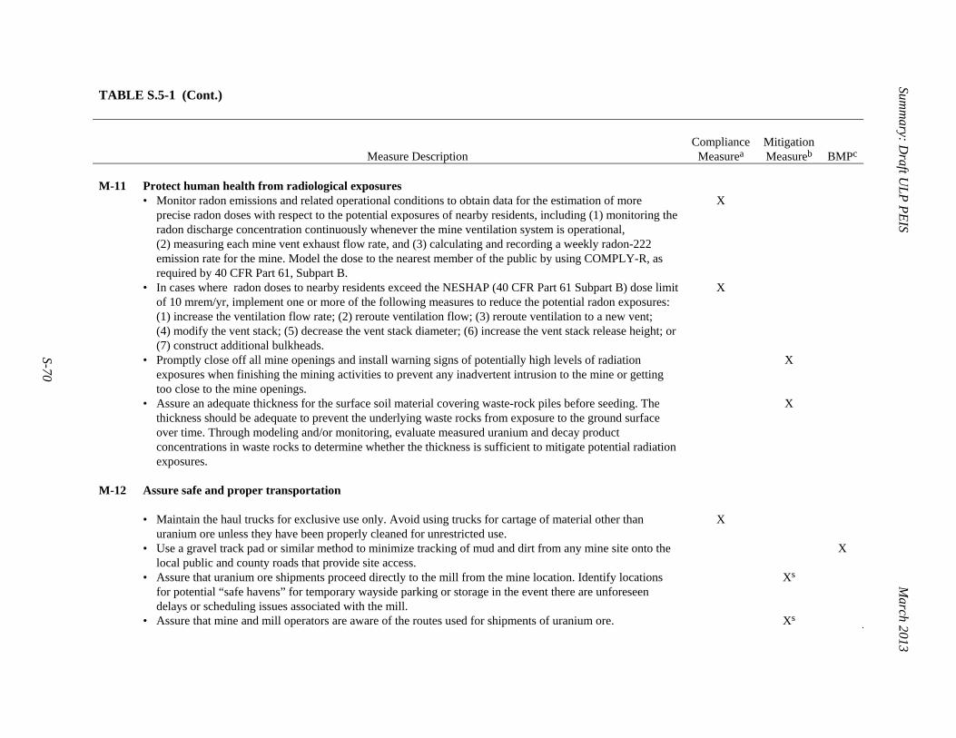
Summ
ary: Draft U
LP
PE
IS
March 2013
S-70
TABLE S.5-1 (Cont.)
Measure Description Compliance
Measurea
Mitigation Measureb BMPc
M-11 Protect human health from radiological exposures • Monitor radon emissions and related operational conditions to obtain data for the estimation of more
precise radon doses with respect to the potential exposures of nearby residents, including (1) monitoring the radon discharge concentration continuously whenever the mine ventilation system is operational, (2) measuring each mine vent exhaust flow rate, and (3) calculating and recording a weekly radon-222 emission rate for the mine. Model the dose to the nearest member of the public by using COMPLY-R, as required by 40 CFR Part 61, Subpart B.
X
• In cases where radon doses to nearby residents exceed the NESHAP (40 CFR Part 61 Subpart B) dose limit of 10 mrem/yr, implement one or more of the following measures to reduce the potential radon exposures: (1) increase the ventilation flow rate; (2) reroute ventilation flow; (3) reroute ventilation to a new vent; (4) modify the vent stack; (5) decrease the vent stack diameter; (6) increase the vent stack release height; or (7) construct additional bulkheads.
X
• Promptly close off all mine openings and install warning signs of potentially high levels of radiation exposures when finishing the mining activities to prevent any inadvertent intrusion to the mine or getting too close to the mine openings.
X
• Assure an adequate thickness for the surface soil material covering waste-rock piles before seeding. The thickness should be adequate to prevent the underlying waste rocks from exposure to the ground surface over time. Through modeling and/or monitoring, evaluate measured uranium and decay product concentrations in waste rocks to determine whether the thickness is sufficient to mitigate potential radiation exposures.
X
M-12 Assure safe and proper transportation • Maintain the haul trucks for exclusive use only. Avoid using trucks for cartage of material other than
uranium ore unless they have been properly cleaned for unrestricted use. X
• Use a gravel track pad or similar method to minimize tracking of mud and dirt from any mine site onto the local public and county roads that provide site access.
X
• Assure that uranium ore shipments proceed directly to the mill from the mine location. Identify locations for potential “safe havens” for temporary wayside parking or storage in the event there are unforeseen delays or scheduling issues associated with the mill.
Xs
• Assure that mine and mill operators are aware of the routes used for shipments of uranium ore. Xs
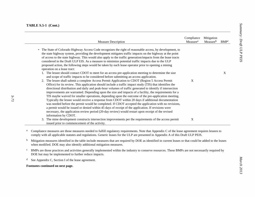
Summ
ary: Draft U
LP
PE
IS
March 2013
S-71
TABLE S.5-1 (Cont.)
Measure Description Compliance
Measurea
Mitigation Measureb BMPc
• The State of Colorado Highway Access Code recognizes the right of reasonable access, by development, to
the state highway system, providing the development mitigates traffic impacts on the highway at the point of access to the state highway. This would also apply to the traffic generation/impacts from the lease tracts considered in the Draft ULP EIS. As a measure to minimize potential traffic impacts due to the ULP proposed action, the following steps would be taken by each lease operator prior to opening a mining operation on a lease tract:
1. The lessee should contact CDOT to meet for an access pre-application meeting to determine the size and scope of traffic impacts to be considered before submitting an access application.
2. The lessee shall submit a complete Access Permit Application to CDOT (Region 5 Access Permit Office) for its review. This application should include a traffic impact study (TIS) that identifies the directional distribution and daily and peak-hour volumes of traffic generated to identify if intersection improvements are warranted. Depending upon the size and impacts of a facility, the requirements for a TIS maybe waived for smaller operations, depending upon the outcome of the pre-application meeting. Typically the lessee would receive a response from CDOT within 20 days if additional documentation was needed before the permit would be completed. If CDOT accepted the application with no revisions, a permit would be issued or denied within 45 days of receipt of the application. If revisions were necessary, the application review period (20-day review) would restart upon receipt of the revised information by CDOT.
3. The mine development constructs intersection improvements per the requirements of the access permit issued prior to commencement of the activity.
X
X
X
a Compliance measures are those measures needed to fulfill regulatory requirements. Note that Appendix C of the lease agreement requires lessees to
comply with all applicable statutes and regulations. Generic leases for the ULP are presented in Appendix A of this Draft ULP PEIS.
b Mitigation measures identified in the table include measures that are required by DOE as identified in current leases or that could be added to the leases when modified. DOE may also identify additional mitigation measures.
c BMPs are those practices and activities generally implemented within the industry to conserve resources. These BMPs are not necessarily required by DOE but may be implemented to further reduce impacts.
d See Appendix C, Section I of the lease agreement.
Footnotes continued on next page.

Summ
ary: Draft U
LP
PE
IS
March 2013
S-72
TABLE S.5-1 (Cont.) 1
e Except for older diesel equipment meeting emissions requirements that need higher sulfur content for proper functioning.
f See Appendix C, Section L of the lease agreement.
g See Appendix C, Section J of the lease agreement.
h The CDRMS requires lessees to obtain permits for their mining operations and to submit and follow an EPP. Runoff and run-on are specifically addressed on a site-by-site basis, as are issues concerning hydrology and reestablishment of vegetation.
i Article XIII MINING PLAN of the lease agreement addresses the process for reclamation; the ULP will work with the BLM to identify and clear local sources of borrow material.
j See Appendix C, Section M of the lease agreement; also required to be submitted under Article XII EXPLORATION PLAN of the lease agreement.
k See Appendix C, Sections G and H of the lease agreement, which address the location of mining infrastructure.
l See Appendix C, Section T of the lease agreement (for applicable lease tracts).
m Requirement of the surface management agency, BLM.
n Chisel plowing is a method used to alleviate shallow soil compaction by inserting a narrow tool in soil to depths of at least 14 in. (35 cm).
o Subsoiling is a method used to alleviate shallow soil compaction by tillage of soil to depths of at least 14 in. (35 cm).
p See Appendix C, Section H of the lease agreement.
q Measure per CPW.
r Primary source of information is USDA and DOI (2007).
s See Appendix C, Section P of the lease agreement.
2 3 4

Summary: Draft ULP PEIS March 2013
S-73
S.6 CUMULATIVE IMPACTS 1 2 Potential impacts from the five alternatives in this Draft ULP PEIS are considered in 4 combination with impacts of past, present, and reasonably foreseeable future actions. For this 5 cumulative impacts analysis, past projects are generally assumed to be reflected in the affected 6 environment discussion. Projects that have been completed, such as the exploration and 7 reclamation activities implemented under the ULP in 2009 and 2011, are generally assumed to 8 be part of the baseline conditions that were analyzed under the five alternatives 9 (see Sections S.3.1.1 through S.3.1.5). As mentioned previously, the region of cumulative effects 10 is conservatively assumed to be a 50-mi (80-km) radius (see Figure S.6-1). For most of the 11 resource areas, a 25-mi (40-km) radius was identified as the ROI. The analyses for potential 12 environmental justice impacts and potential impacts on the human health of the population 13 generally addressed a 50-mi (80-km) radius, which is why the region of cumulative effects was 14 extended to this larger radius (see Appendix D for information on how the radius was identified 15 as the ROI for each resource area). 16 17 The major ongoing projects that are related to uranium mining activities proposed under 18 the five alternatives evaluated in this Draft ULP PEIS include (1) the White Mesa Mill; 19 (2) various permitted uranium mining projects in Montrose, Mesa, and San Miguel Counties, 20 none of which are currently actively producing (of the 33 permitted projects, a few of the permits 21 are for mines on the DOE ULP lease tracts); (3) the Daneros Mine; (4) the Energy Queen Mine, 22 which is operational but currently inactive; and (5) the ongoing reclamation of abandoned 23 uranium mines (these mines are not on the DOE ULP lease tracts). There are also several 24 foreseeable projects related to uranium mining, which are currently in the planning phase. These 25 include the Piñon Ridge Mill5 and the Whirlwind Mine near Gateway. 26 27 Projects that are not related to uranium mining include the operating Nucla Station Power 28 Plant; the Lisbon Natural Gas Processing Plant; the New Horizon Coal Mine; other mineral 29 mining projects (for sand, gravel, gold, quartz, and granite); oil and gas exploration, transmission 30 line, and transportation ROW projects; grazing and wildlife and vegetation management projects; 31 and National Monument improvement projects. 32 33 The environmental impacts discussion in Section S.4 (and summarized in Tables S.4-5 34 through S.4-7) concludes that potential impacts on the resource areas evaluated for the five 35 5 Energy Fuels Resources Corporation has planned to construct the Piñon Ridge Mill (a conventional uranium
mill) in Paradox Valley, between Naturita and Bedrock in Montrose County, Colorado. In early 2011, the Colorado Department of Public Health and Environment (CDPHE) issued a final radioactive materials license to Energy Fuels Resources Corporation (which is the main asset of Ontario’s Energy Fuels Resources, Inc., located in Lakewood, Colorado), following CDPHE’s preparations of a decision analysis and environmental impact analysis (CDPHE 2011). A group of plaintiffs then challenged that license by filing a lawsuit against CDPHE in Colorado’s District Court for the City and County of Denver. On June 13, 2012, the court issued a decision in which it held that the CDPHE had unlawfully issued the license without conducting the necessary administrative procedures. The court set aside CDPHE’s action in issuing the license, remanded the case for further proceedings, and ordered CDPHE to convene an additional hearing. As of the present date, CDPHE has convened that hearing, and further proceedings have been scheduled. Pursuant to CDPHE’s tentative schedule, by April 2013 it will take final agency action and make a new decision on whether or not to issue the license.

Summary: Draft ULP PEIS March 2013
S-74
1
FIGURE S.6-1 Region of Cumulative Effects 2
Summary: Draft ULP PEIS March 2013
S-75
alternatives generally would be minor and could be further minimized by implementing the 1 compliance and mitigation measures and/or BMPs as required by project-specific mine plans. 2 Estimates for potential human health impacts indicate that the emission of radon would be the 3 primary source of potential human health radiation exposure. However, requirements for 4 monitoring and ventilating mine operations and for worker safety are expected to mitigate 5 potential impacts on human health. The potential radon dose estimates presented in the Draft 6 PEIS were calculated by using conservation assumptions that the radon emission rate is 7 proportional to the cumulative uranium production and the uranium mines have been in 8 operation for 10 years. Actual radon dose based on measured radon emission data should be used 9 to obtain more realistic radon exposure estimates. 10 11 Although the various present, ongoing, and planned projects identified in the region of 12 cumulative effects could contribute to impacts on the various environmental resource areas 13 evaluated, it is expected that uranium-mining-related projects would be most similar with respect 14 to the types of potential environmental impacts that could occur, and most of these are located 15 closer to (within 25 mi or 40 km) the lease tracts. However, information for most of the projects 16 is either not available or qualitative in nature. 17 18 Potential impacts from the five alternatives would generally be negligible to moderate. 19 The potential (incremental) impacts from the five alternatives are tabulated in Tables S.4-5 20 through S.4-7. 21 22 For specific resources, the cumulative impacts as well as the incremental contributions to 23 these impacts from implementation of the ULP under any of the five alternatives are summarized 24 below: 25 26
• Air quality. Because of the relatively low population density, low level of 27 industrial activities, and relatively low traffic volume in the ULP region, the 28 quantity of anthropogenic emissions is small and the ambient air quality is 29 relatively good. Particulate emissions associated with ongoing actions in the 30 region, such as White Mesa Mill and uranium mining, and planned actions, 31 such as Piñon Ridge Mill, are not expected to exceed ambient air quality 32 standards. Cumulative impacts on air quality in the ULP region are therefore 33 considered to be minor. Under Alternatives 1 and 2, PM10 and NOx emissions 34 during reclamation are estimated to be less than 1% and 0.1% of the emission 35 totals, respectively, for the Colorado counties (Mesa, Montrose, and San 36 Miguel) encompassing the ULP lease tracts. Under Alternatives 3 through 5, 37 PM10 and NOx emissions are estimated to be highest during the development 38 and operations phase, ranging from 1.5 to 3.2% (PM10) and 1.0 to 2.3% (NOx) 39 of emission totals. The contribution of any alternative to cumulative impacts 40 in the region is expected to be negligible to minor. None of the ULP 41 alternatives would cause measurable impacts on regional ozone or AQRVs at 42 nearby Class 1 areas. 43
44

Summary: Draft ULP PEIS March 2013
S-76
• Acoustic environment. There are no sensitive receptors (such as hospitals or 1 schools) within 3 mi (5 km) of the ULP lease tracts, and only 17 residences lie 2 within 1 mi (1.6 km) of the lease tracts (7 of which are adjacent to a lease 3 tract). Although there are no noise surveys of the immediate vicinity, it is 4 likely that the highest human-caused noise levels (in the range of 50 to 5 60 dBA) in the ULP region are intermittent and associated with state 6 highways and agricultural/industrial activities. Planned and ongoing actions, 7 such as the Piñon Ridge Mill and uranium mining, are not expected to exceed 8 the maximum permissible noise levels. Noise-related cumulative impacts are 9 therefore considered minor. Noise levels associated with reclamation activities 10 under Alternatives 1 and 2 would be about 55 dBA at a distance of about 11 1,650 ft (500 m) from the reclamation site; this is the Colorado daytime 12 maximum permissible limit in a residential zone. Under all alternatives, noise-13 related impacts are expected to be local and intermittent and, therefore, minor. 14 Noise levels could exceed the Colorado limit at Lease Tract 13 under 15 Alternatives 1 through 3 and at Lease Tracts 13, 13A, 16, and 16A under 16 Alternatives 4 and 5, if any activities occurred near the boundary. The 17 contribution of any of the five ULP alternatives to cumulative noise-related 18 impacts in the region is expected to be minor. 19
20 • Paleontological resources. Significant paleontological resources within the 21
ULP lease tracts (the region of cumulative effects) are associated with 22 stratigraphic units of Jurassic and Cretaceous age. The PFYC ranking of the 23 Jurassic-age Morrison Formation, the main source of uranium in the lease 24 tracts and the geologic unit most likely to be affected by future mining, is 5 25 (very high), indicating that it is highly fossiliferous and most at risk for 26 human-caused adverse impacts or natural degradation. Other uranium mines 27 in the region have acknowledged the potential for discovering or damaging 28 vertebrate fossils within in the Morrison Formation. Because there are 29 compliance-driven measures governing the management of paleontological 30 resources on Federal lands, the cumulative impacts on these resources are 31 considered to be minor. Lessees would follow requirements set forth in 32 project-specific paleontological management plans prepared in consultation 33 with the BLM. Therefore, the contribution of any of the five ULP alternatives 34 to cumulative impacts on paleontological resources is expected to be minor. 35
36 • Soil resources. Cumulative impacts on soil resources within and adjacent to 37
the ULP lease tracts (the region of cumulative effects) would result mainly 38 from ground-disturbing activities associated with mining activities under any 39 of the five alternatives. These impacts are expected to be minor to moderate, 40 but they would be short in duration and generally controlled through 41 mitigation measures and BMPs. 42
43 • Water resources. Water resources in the region of cumulative effects include 44
surface water in the Upper Dolores, San Miguel, and Lower Dolores 45

Summary: Draft ULP PEIS March 2013
S-77
watersheds; groundwater in the bedrock aquifers within Paradox Basin; and 1 alluvial aquifers within the various canyons along the Dolores and San Miguel 2 Rivers. Cumulative impacts on stream flow in the Dolores River are 3 considered moderate due mainly to the effects of regulated flow by the 4 McPhee Dam located upstream of the ULP lease tracts. Changes in the water 5 cycle due to seasonal shifts in precipitation (and a decline in snowpack) are 6 projected to cause up to a 20% decrease in runoff in the Upper Colorado River 7 Basin (of which the Dolores and San Miguel Rivers are a part) in the 8 foreseeable future; the decrease in runoff will also affect recharge rates in 9 aquifers throughout the region. Water consumption, especially in terms of 10 irrigation from surface water sources, is already on the decline because of 11 regional drought conditions, and this trend is likely to continue into the 12 foreseeable future. In terms of water quality, the cumulative impacts on 13 groundwater and surface water in the Paradox Basin are considered to be 14 moderate, due mainly to the naturally high saline groundwater that discharges 15 to the Dolores River in Paradox Valley. Activities associated with ongoing 16 actions in the region, such as the White Mesa Mill and uranium mining, and 17 planned actions such as the Piñon Ridge Mill, could reduce runoff to the 18 Dolores River; however, water quality impacts are not expected. Under all 19 five alternatives, minor impacts on water quality could occur as a result of 20 land disturbance and underground mining activities associated with mine 21 development, operations, and reclamation; these impacts would be minimized 22 by the implementation of compliance and mitigation measures and/or BMPs 23 (Table 4.6-1). Minor (local and temporary) impacts on stream flow are also 24 expected. 25
26 • Human health. Exposures from background radiation sources within a 50-mi 27
(80-km) radius of the ULP lease tracts were estimated on the basis of two 28 hypothetical scenarios: (1) considering an individual who lives near the lease 29 tracts; and (2) considering an individual pumping out groundwater from a well 30 for drinking. Potential dose estimates show that an individual could receive a 31 dose of about 120 mrem/yr from ambient gamma radiation, 290 mrem/yr from 32 inhalation of radon, 0.47 mrem/yr from breathing airborne radionuclides in 33 resuspended dust particles, and 25 mrem/yr from drinking untreated well 34 water. The probability that such a person would incur an LCF is estimated to 35 be about 5 × 10⁻⁴ (i.e., 1 in 2,000 [2 × 10³]). Dose estimates associated with 36 White Mesa and Piñon Ridge Mills (to the nearest receptor at the site 37 boundary) range from 5.8 to 8.2 mrem/yr. The contribution of any of the five 38 ULP alternatives to cumulative impacts due to radiation exposure in the 39 region is expected to be negligible, ranging only from 1 to 10 mrem/yr for a 40 resident living more than 1.5 mi (2,500 m) from the lease tract. The potential 41 dose could be higher if the distance is less than 1.5 mi (2,500 m), but the dose 42 would still be less than 31 mrem/yr, which corresponds to a probability of 43 4 × 10⁻⁵ to develop a latent fatal cancer (i.e., 1 in 2,500 [2.5 × 10⁴]). 44
45

Summary: Draft ULP PEIS March 2013
S-78
• Ecological resources (vegetation). The region of cumulative effects 1 (Montrose, Mesa, and San Miguel Counties) supports a wide variety of 2 vegetation types, primarily woodlands and shrublands. Incremental impacts on 3 vegetation result mainly from ground disturbance (which can destroy 4 vegetation and introduce non-native species); indirect impacts include 5 deposition of fugitive dust, soil erosion, sedimentation, and changes in water 6 quantity or quality. Impacts are expected to be minor to moderate; 7 establishment of native plant communities during reclamation would reduce 8 impacts over the long term. 9
10 • Ecological resources (wildlife). Incremental impacts on wildlife in the region 11
of cumulative effects (Montrose, Mesa, and San Miguel Counties) result 12 mainly from habitat disturbance. Such impacts could be minor to moderate in 13 the short term but would be localized and would not affect the viability of 14 wildlife populations. 15
16 • Ecological resources (aquatic biota). The region of cumulative effects 17
(Montrose, Mesa, and San Miguel Counties) contains a variety of freshwater 18 aquatic habitats that support a wide diversity of aquatic biota. Incremental 19 impacts result from the disturbance of these habitats, sedimentation (due to 20 soil erosion from mine sites), or changes in water quantity or quality due to 21 alterations in drainages or releases of contaminants into aquatic systems. 22 Overall, these impacts are expected to be negligible to minor for all project 23 phases under each of the five ULP alternatives; moderate impacts would be 24 expected only if mines were located near perennial water bodies. 25
26 • Ecological resources (threatened, endangered, and sensitive species). 27
Incremental impacts on threatened, endangered, and sensitive species would 28 be similar to those described for vegetation, wildlife, and aquatic biota. 29
30 • Land use. Most of the lands surrounding the ULP lease tracts are managed by 31
the BLM under its “multiple use” management framework. These lands are 32 currently managed for uses that include conservation, recreation, agriculture 33 (including grazing), rangeland, and minerals (via mining, leasing, and free 34 use). Because these lands are managed under the authority of the BLM and 35 USFS, the cumulative impacts within the 25-mi (40-km) radius (the region of 36 cumulative effects) are considered to be minor. Lands within the Uravan 37 Mineral Belt, including those on which the ULP lease tracts are located, were 38 withdrawn from mineral entry in 1948 in order to reserve them for the 39 exploration and development of uranium and vanadium resources. Under 40 Alternatives 1 and 2, all mining activities on these lands would cease, and 41 other activities within the lease tracts would continue. The contributions of the 42 ULP to cumulative impacts in the region would be minor since there would be 43 no conflict between mining and other uses. Under Alternatives 3 through 5, 44 mining activities within the lease tracts may preclude certain other uses (such 45 as recreation and grazing), but their contributions to cumulative impacts 46

Summary: Draft ULP PEIS March 2013
S-79
would also be considered minor since the surrounding lands offer ample 1 opportunity for these other uses. 2
3 • Socioeconomics. Cumulative socioeconomic impacts result from changes in 4
employment opportunities and income, expenditures for goods and services, 5 and tax revenues associated with various types of commercial, industrial, and 6 recreational activities that are taking place within the region of cumulative 7 effects (Montrose, Mesa, and San Miguel Counties). These impacts are 8 generally considered beneficial to local communities, counties, and states. 9 Unemployment in the three-county region is currently 9.6% (2011). Under 10 Alternatives 1 and 2, socioeconomic impacts are expected to be minor, 11 increasing the total employment by about 0.1% in the region. Under 12 Alternatives 3 through 5, impacts would also be minor, increasing the total 13 employment by less than 1% in the region. 14
15 • Environmental justice. Cumulative environmental justice impacts would 16
encompass any (and all) human health and environmental impacts that could 17 be disproportionately high and adverse on minority or low-income 18 populations; however, there are no minority or low-income populations, as 19 defined by CEQ guidelines, within the region of cumulative effects. As a 20 result, there would be no anticipated cumulative impacts on these populations, 21 and no contribution to these impacts from any of the five ULP alternatives. 22
23 • Transportation. Most roads in the region of cumulative effects pass through 24
uninhabited public lands; however, routes used to haul uranium ore over the 25 past 10 to 30 years pass 13 of 15 residences along the ULP lease tracts. Traffic 26 volume along these routes is expected to increase with the continued operation 27 of White Mesa Mill, the construction of Piñon Ridge Mill, and future uranium 28 mining in the region. Under Alternatives 1 and 2, there would be no transport 29 of uranium ore and therefore no change in current traffic trends. Ore 30 shipments under Alternatives 3 through 5 would increase truck traffic along 31 affected routes and would contribute to cumulative impacts, such as human 32 exposure to low levels of radiation, increased traffic, and potential accidents. 33 It is estimated that the number of shipments from mines to mills could be as 34 high as 92 per day under Alternative 5. The average external dose rate is about 35 0.1 mrem/h at 6.6 ft (2 m), two orders of magnitude lower than the regulatory 36 maximum. Estimated potential impacts include no LCFs to the collective 37 population, no traffic fatalities, and possibly one traffic injury under 38 Alternatives 4 and 5. 39
40 • Cultural resources. Incremental impacts from the five ULP alternatives could 41
result from vandalism, theft, and damage or destruction of cultural artifacts 42 within the lease tracts or in adjacent areas affected by mining activities. 43 Adverse impacts on traditional cultural properties are also counted among the 44 direct impacts on cultural resources. Direct impacts on these resources are not 45

Summary: Draft ULP PEIS March 2013
S-80
expected under Alternatives 1 and 2; however, vandalism and theft are 1 possible impacts because of greater site accessibility. Ground disturbance 2 under Alternatives 3 through 5 could damage or destroy artifacts and 3 traditional cultural properties, and artifacts could be lost through vandalism or 4 theft as a result of improved site access. Such impacts would be minimized or 5 avoided, since all activities would comply with Section 106 of the NHPA. 6
7 • Visual resources. Incremental impacts from the five ULP alternatives relate 8
mainly to alterations to vegetation and landforms, removal of structures and 9 materials, changes to roadways, and changes in vehicular and work activities. 10 Although impacts associated with exploration are generally expected to be 11 minor, potential long-term impacts could result from mine development and 12 operations, as would occur under Alternatives 3 through 5, because activities 13 during these phases could increase contrasts in form, line, color, and texture. 14 The magnitude of these impacts would need to be determined at the project 15 level. 16
17 • Waste management. Incremental impacts on waste management within the 18
lease tracts (the region of cumulative effects for waste management) are 19 associated with the generation of waste from the various mining phases. These 20 impacts are expected to minor under all five of the ULP alternatives. 21
22 Potential cumulative impacts on the various environmental resources (e.g., air quality, 23 water quality, soils, ecological resources, socioeconomics, transportation) and human health 24 from various past, present, and reasonably foreseeable projects and activities within the 50-mi 25 (80-km) ROI, which include the impact of these activities when added to activities related to the 26 ULP, would vary by resource but would generally range from negligible to moderate (see 27 Table S.4-1). The overall contribution of the ULP to these impacts is considered to be minor.6 28 29 30 S.7 HOW THE PUBLIC CAN PARTICIPATE 31 32 DOE is soliciting comments on the Draft ULP PEIS during a 60-day public comment 33 period, during which public hearings will be held to provide interested members of the public 34 with opportunities to learn more about the content of the ULP PEIS, hear DOE representatives 35 present a summary of the results of the Draft ULP PEIS analyses, ask clarifying questions, and 36 6 Because of the qualitative nature of information presented for most projects or activities in the region of
cumulative effects, it is not possible to determine an overall cumulative impact in a quantitative sense. Even for projects where quantitative results are calculated or estimated, (e.g., for air emissions, human health doses, transportation, and socioeconomics), the methodology and associated assumptions used for the calculations vary, making definitive comparisons among projects difficult. For this Draft ULP PEIS, the potential incremental impacts of the five alternatives are based on conservative assumptions and mostly do not take credit for measures (compliance measures, mitigation measures, and BMPs) that would minimize the potential impacts. Hence, it is expected that the potential incremental impacts of the ULP would be less than those summarized in S.4-5 through S.4-7, since such measures would be implemented as required by project-specific mine plans and permits.

Summary: Draft ULP PEIS March 2013
S-81
provide oral and written comments. The ULP PEIS web site (http://www.ulpeis.anl.gov) 1 provides detailed information about the Draft ULP EIS, public hearings, comment submission, 2 and other pertinent information. 3 4 5 S.8 LOCATIONS AND DATES OF THE PUBLIC HEARINGS 6 7 Public hearing dates, times, and locations will be announced in the Federal Register, in 8 local newspapers, on the ULP PEIS web site (http://www.ulpeis.anl.gov), and on the DOE NEPA 9 web site (http://energy.gov/nepa). 10 11 12 S.9 REFERENCES 13 14 AEC (U.S. Atomic Energy Commission), 1972, Leasing of AEC Controlled Uranium Bearing 15 Lands, Colorado, Utah, New Mexico, WASH-1523, Sept. 16 17 APLIC (Avian Power Line Interaction Committee), 2006, Suggested Practices for Avian 18 Protection on Power Lines: The State of the Art in 2006, Edison Electric Institute, APLIC, and 19 the California Energy Commission, Washington, D.C., and Sacramento, Calif. Available at 20 http://www.aplic.org/SuggestedPractices2006(LR).pdf. Accessed March 25, 2008. 21 22 APLIC and USFWS (U.S. Fish and Wildlife Service), 2005, Avian Protection Plan (APP) 23 Guidelines, April. Available at http://www.eei.org/industry_issues/environmental/land/ 24 wildlife_and_endangered_species/AvainProtectionPlanGuidelines.pdf. Accessed March 7, 2007. 25 26 BLM (Bureau of Land Management), 1995, Uranium Closure/Reclamation Guidelines, 27 supplement to the BLM Solid Minerals Reclamation Handbook, BLM Handbook H-3042-1. 28 29 BLM and DOE (U.S. Department of Energy), 2010, Memorandum of Understanding between the 30 U.S. Bureau of Land Management and the U.S. Department of Energy, April. 31 32 CPW (Colorado Parks and Wildlife), 2008, Recommended Buffer Zones and Seasonal 33 Restrictions for Colorado Raptors. Available at http://wildlife.state.co.us/ 34 SiteCollectionDocuments/DOW/Wildlife Species/LivingWithWildlife/RaptorBufferGuidelines 35 2008.pdf. Accessed Sept. 14, 2012. 36 37 Denman, A.R., et al., 2003, “Assessment of Health Risks to Skin and Lung of Elevated Radon 38 Levels in Abandoned Mines,” Health Physics 85(6), Dec. 39 40 DOE (U.S. Department of Energy), 1995, Finding of No Significant Impact, Uranium Lease 41 Management Program. 42 43

Summary: Draft ULP PEIS March 2013
S-82
DOE, 2007, Uranium Leasing Program, Final Programmatic Environmental Assessment, 1 DOE/EA-1535; also Finding of No Significant Impact for the Uranium Leasing Program, Office 2 of Legacy Management, July. 3 4 DOE and CDRMS (Colorado Division of Reclamation, Mining, and Safety), 2012, 5 Memorandum of Understanding between the U.S. Department of Energy and the Colorado 6 Division of Reclamation, Mining, and Safety, Sept. 7 8 USDA (U.S. Department of Agriculture) and DOI (U.S. Department of the Interior), 2007, 9 Surface Operating Standards and Guidelines for Oil and Gas Exploration and Development, 10 BLM/WO/ST-06/021+3071/REV 07, Denver, Colo. Available at http://www.blm.gov/wo/ 11 st/en/prog/energy/oil_and_gas/best_management_practices/gold_book.html. Accessed Nov. 2, 12 2012. 13 14