summary - new brunswick · 1 sisson project eia report summary the completed environmental impact...
TRANSCRIPT

SUMMARY
Sisson Mine Project Environmental Impact Assessment Report
For the proposed construction and operation of
an open pit tungsten and molybdenum mine near Napadogan, New Brunswick
by Sisson Mines Ltd.
Prepared by the New Brunswick Department of Environment and Local Government
April 2015
1
Sisson Project EIA Report Summary The completed Environmental Impact Assessment Report (EIA) regarding the proposed Sisson Project contains more than 1,600 pages in 12 Chapters and 2 Volumes. It was prepared by Stantec Inc. on behalf of the Project Proponent – Sisson Mines Limited (SML). This summary of Stantec’s EIA Report has been prepared by the New Brunswick Department of Environment and Local Government (NBDELG). It’s aimed at assisting interested stakeholders and the public in understanding the assessments described in the full document; the major issues covered, and the conclusions reached by Stantec’s study team. This summary is also designed to serve as a detailed reader’s guide to the final EIA Report. A total of 303 individual tables and 214 illustrative figures are contained in the full document. Only a few of these graphic components are reproduced in the NBDELG summary. But a comprehensive list is also provided, showing where to locate each and every table and figure in the complete Report. To aid interested stakeholders and the public, this NBDELG summary and the EIA Report itself are now simultaneously available for public review. This should help readers of this summary locate further more detailed information in relevant sections of the full document. A ‘General Review Statement’ concerning the completed Sisson Project EIA is also now publicly available and has been issued by the NB Technical Review Committee (TRC). The TRC is a group of diverse technical specialists from various provincial and federal agencies who were appointed by the NB Minister of Environment regarding this specific EIA process. The ‘General Review Statement’ provides specific comments from the TRC in response to the full Report. As required by the New Brunswick EIA Regulation, all three documents above are now available to the public as follows:
• Copies of the Summary of the EIA Report and the General Review Statement are available at the following locations:
- Burtts Corner: Birds Corner Store, 002, Route 104 - Florenceville-Bristol: Town office, 4724 Juniper Road - Fredericton: Department of Environment and Local Government, 20 McGloin Street (Marysville
Place); Fredericton Public Library, 12 Carleton Street; Nashwaaksis Public Library, Nashwaaksis Middle School, 324 Fulton Avenue
- Juniper: Mills Convenience Store, 6765, Route 107 - Millville: Village office, 39 Howland Ridge Road - Nackawic: Town office, 26 Pinder Road - Stanley: Village office, 20 Main Street, Stanley Community Library, 28 Bridge Street, Unit 2,
Hillside Convenience, 30 Main Street - Tay Creek: Tay Creek Country Store, 3789, Route 620 - Woodstock: Town office, 824 Main Street
Copies of the complete EIA Report in both official languages are available for referencing at the municipal offices and libraries listed above. All documents, including the complete EIA Report, are also accessible online at www.gnb.ca/environment.

2
• A public meeting will be held on June 22, 2015 beginning at 7 p.m. in the Stanley High School gymnasium, 28 Bridge Street, Stanley, NB
To register to make a presentation at the public meeting, please contact the Department of Environment and Local Government at (506) 453-3700. The public meeting will also provide opportunity for general comments. Simultaneous Interpretation will be provided at the public meeting. If you require sign language interpretation or an assistive listening device, please call (506) 633-0599 (TTY).
• Written comments can be submitted until July 17, 2015 in the official language of your choice
and should be forwarded to:
The Department of Environment and Local Government, Education and Engagement Branch, P.O. Box 6000 (20 McGloin Street), Fredericton, NB E3B 5H1 Tel: (506) 453-3700, Fax: (506) 453-3676, Email: EIA/[email protected]
NBDELG Summary - Vol.1 Volume 1 of the EIA Report includes 7 Chapters and covers a total of 554 pages. In addition to the narrative text, it provides additional detailed information in 158 tables and 119 illustrative figures. Chapter 1 – Introduction The opening chapter of Vol. 1 covers pages 1.1 to 1.19. It includes 4 sections; 10 sub-sections, 2 tables and 4 figures. The Report begins by explaining that the proposed Sisson Project would involve construction and operation of an open pit tungsten and molybdenum mine near Napadogan, approximately 60 km directly northwest of Fredericton. Following a two year construction period, the mine would operate for an estimated 27 years. Ore from the open pit would be mined and processed on-site, at an average rate of approximately 30,000 tonnes per day. The resulting mineral products would be trucked to nearby rail facilities for subsequent transportation to customers. Waste rock from the open pit, and tailings as a by-product of the ore processing operations, would be permanently stored in a tailings storage facility (TSF). At the end of mining, decommissioning, reclamation and closure would restore the site to near natural conditions, and to meet end land uses agreed with the New Brunswick Government, First Nations and other stakeholders. The Report notes that development of the proposed project was registered under the New Brunswick EIA Regulation in 2008. A federal environmental assessment regarding the project was also initiated in 2011 by the Canadian Environmental Assessment Agency (CEAA). The purpose of the EIA Report is to document the results of the EIA required to satisfy requirements of both the NB EIA Regulation and CEAA. The capital cost of the Project is estimated at C$579 million and the projected expenditures for the entire period of operation of the Project are estimated at C$3.7 billion. The Project would create up to 500 direct jobs during the construction phase, and up to 300 direct full-time jobs over its operating lifespan.

3
The Project Development Area (PDA) is shown in Figure 1.2.1 which is reproduced on the following page. The PDA would cover 1,253 hectares (3,096 acres). The Report notes that the PDA has a long history of natural resource development and use, including extensive forest resource harvesting. It is also integral to the ecology of the Nashwaak and St. John River watersheds; lies within the traditional territory of the Maliseet First Nations, and is important for hunting, fishing, and outdoor recreation.

!
!
!
!
!
!
!
!
!
!
!
!
!
!
!
!
!
!
!
!
!
!
!
!
!
!
!
!
!
!
!
!
!
!
!
!
!
!
!
!
!
!
!
!
!
!
!
!
!
!
!
!
!
!
!
!
!
!
!
!
!
!
!
!
!
!
!
!
!
!
!
!
!
!
!
!
!
!
!
!
!
!
!
!
!
!
!
!
!
!
!
!
!
!
!
!
!
!
!
!
!
!
!
!
!
!
!
!
!
?
?
?
??
?
?
?
?
?
??
?
?
?
?
?
?
??
?
?
?
?
?
?
?
??
?
?
?
?
?
?
?
?
?
?
?
!
!
!
!
!
!
!
!
!
!
!
!
!
!
!
!
!
!
!
!
!
!
!
!
!
!
!
!
!
!
!
!
!
!
!
!
!
!
!
!
!
!
!
!
!
!
!
!!!!!!!
!
!
!
!
!
!
!
!
!
!
!
!
!
!
!
!
!
!
!
!
!
!
!
!
!
!
!
!
!
!
!
!
!
!
!
!
!!!!!!!
!
!
!
!
!
!
!
!
!
!
!
!
!
!
!
Tailings Storage Facility(TSF)Quarry
Open Pit
Relocated 345 kV Transmission Line and
Fire Road
Existing 345 kV Transmission Line Relocation
Access Road
Truck ShopNew 138 kV Transmission Line and
Access Road
Existing 345 kV Transmission Line Relocation, New 138 kV Transmission Line,
and Relocated Fire Road
Process Plant
Conveyor
Crusher
New 138 kV Transmission Line from
Keswick Terminal
Relocated Fire Road
Water Management Ponds
Topsoil Stockpile
Bird Brook
McBean Brook
Sisso
n Broo
k
West Branch Napadogan Brook
Manzer B rook
Barker B rook
East Brook
Project Development Area (PDA)
Sisson Mines Ltd.Client:
±
NOTE: THIS DRAWING ILLUSTRATES SUPPORTING INFORMATION SPECIFIC TO A STANTEC PROJECT AND SHOULD NOT BE USED FOR OTHER PURPOSES.
0 1 2 3
Kilometres
Scale:
Date:
Project No.:
Dwn. By: Appd. By:
Fig. No.:
1.2.1121810356
JAB DLMMap: NAD83 CSRS NB Double Stereographic
1:45,000Data Sources:SNBNRCAN, ESRI
(dd/mm/yyyy)
Stantec Consulting Ltd. © 2013
Millville
Village of Stanley
CardiganCardiganTaymouthTaymouth
Tay CreekTay Creek
NapadoganNapadogan
Burtts CornerBurtts Corner
Sisson Project: Environmental Impact Assessment (EIA) Report, Napadogan, N.B.
23/11/2014
Path:
V:\01
218\a
ctive
\1218
1035
6\gis\
mapp
ing\m
xd\ei
a\1_in
trodu
ction
\fig_1
_2_1
_201
3032
7_pd
a_nl.
mxd
Legend
! ! New 138 kV Transmission Line? Clean Water Diversion Channel? Mine Contact Water Collection Channel
Project Development Area (PDA)Topsoil StockpileWater Management PondWatercourse
Tailings Storage Facility (TSF)Major RoadSecondary RoadLimited Use Road
! ! Existing Transmission LineWaterbody
! !Existing 345 kV Transmission Line Relocation
Embankment Crest
5
The Report notes that the Proponent has been committed to engaging with the public, stakeholders and Aboriginal communities in an open, transparent, and responsive manner. Examples showing where sustainable development principles have been incorporated in planning and design of the Sisson Project are also provided. These include the following:
• The configuration of the open pit has been optimized to maximize the recovery of ore from the Sisson deposit, while minimizing its footprint.
• The ore processing plant, TSF, and associated facilities would all be sited within a single watershed, Napadogan Brook, for maximum effectiveness of responsible water management, and ultimate closure of the project.
• The ore processing plant, TSF, and other major Project components would be sited in very
close proximity to the open pit location, thereby minimizing hauling and pumping distances for maximum energy efficiency.
• The TSF has been designed to exceed the requirements of Canadian Dam Association
guidelines, to ensure it will readily withstand the effects of extreme storm events and earthquakes.
• The TSF has been sited to avoid water bodies to the extent possible, and its proposed
location would avoid disturbing lakes in the area, some of which support recreational fisheries. The size and configuration of the TSF have been optimized to avoid unnecessary disturbance or destruction of fish habitat, as well as areas having concentrations of sites with elevated archaeological potential.
• All potentially acid generating process tailings would be stored under water in the TSF to
effectively mitigate the potential onset of acid generation. • All waste rock (some of which is potentially acid generating) would also be stored under water
in the TSF, rather than in a separate waste rock storage area on the land surface. This conservative design feature avoids the need to collect and treat potentially acidic drainage that could otherwise occur from its storage, and minimizes potential environmental effects. Storing waste rock under water in the TSF would effectively mitigate acid generation from the rock.
• No waste rock would be used to build the TSF embankments, since some is potentially acid
generating. Instead, a quarry will be developed on-site to provide rock for the embankments which is not potentially acid generating.
• Ammonium paratungstate (APT) would be produced on-site as an added-value end product,
enhancing job creation and economic benefits.
The Report explains that it has been developed to meet the requirements of the Final Guidelines issued under the New Brunswick EIA Regulation, and Terms of Reference that form the Scope of the EA under CEAA. It notes that the full EIA Report is organized in twelve chapters, as follows.

6
• Chapter 1 provides an introduction to the EIA Report, identifies the Proponent and provides a brief Project overview, provides context for the Project, and outlines the structure and content of the EIA Report.
• Chapter 2 describes the planning of the Project. It outlines the principles and philosophies applied by the Proponent in design, construction, operation, ultimate decommissioning, reclamation and closure of the Project. Environmental management initiatives and practices that would be implemented as part of the Project to minimize environmental effects are also covered.
• Chapter 3 provides a detailed Project Description of the proposed elements of the Sisson Project, including how the Project will be constructed, operated, ultimately decommissioned, reclaimed and closed at the end of mine life. Alternative means of carrying out the Project that would be technically and economically feasible are discussed. Emissions and wastes, transportation requirements, and employment and expenditure for the Project are also described.
• Chapter 4 provides a discussion of the applicable regulatory framework, including the regulatory requirements for the EIA; the scope of the Project and the scope of the EIA; a summary of public, stakeholder, Aboriginal, and regulatory consultation and engagement efforts; and other matters relevant to the scoping of the EIA. The valued environmental components (VECs) that have been selected for the EIA are identified. Additionally, a list of other projects and activities that are considered for the assessment of cumulative environmental effects is provided.
• Chapter 5 provides a description of the methodology used to conduct this EIA to meet the requirements of the EIA Regulation and CEAA.
• Chapter 6 provides a summary of the existing environmental setting of the Project area, including the historical setting, ecological and socioeconomic context of the region.
• Chapter 7 provides a summary of the key predictive studies that were carried out to provide information or analyses to support the environmental effects assessment of the Project.
• Chapter 8 provides the assessment of potential environmental effects of the Project, including cumulative environmental effects, on various VECs of relevance and importance to this EIA, for all Project phases, as well as for accidents, malfunctions, and unplanned events.
• Chapter 9 describes the follow-up and monitoring program that would be developed regarding the Project.
• Chapter 10 summarizes the mitigation measures proposed for the Project.
• Chapter 11 provides conclusions of the EIA.
• Chapter 12 provides the references cited or consulted in the preparation of the EIA Report. Additional supporting information is provided in the Appendices.

7
Chapter 2 – Project Planning and Management Chapter 2 covers pages 2-1 to 2.10. It includes 7 sections; 8 sub-sections, 2 tables, and 4 figures. This chapter begins by providing corporate information on SML. It then explains that Tungsten is an important alloy in tool making and construction steel, enhancing hardness, cutting efficiency and speed, with a similar hardness to diamonds. Tungsten components are used in lighting technology, transportation, the electronic, chemical and glass industries, medical technology, power engineering, and in jewelry. Molybdenum is an important alloy in the manufacture of stainless steel and steel. It is also an important material for the chemical and lubricant industries. Molybdenum is used in automotive parts, construction equipment, gas transmission pipes, and turbine parts. The Report states that, as a major employer and economic driver over its 29 year lifetime, the Project would bring much-needed employment to the Central New Brunswick communities that surround it, and contribute considerably to the overall well-being of the region. It also highlights planning and management strategies to avoid or minimize the adverse environmental effects of the Project, and enhance positive ones. These would include:
• Adopting guiding principles for design and implementation of the Project, particularly those that protect surface water and groundwater resources using geo-technically stable materials and concepts.
• Implementing technically and economically feasible components and technologies that are proven, limiting the footprint and visual effects of the Project, and designing the Project components with closure in mind;
• Incorporating feedback received from the public, stakeholders, Aboriginal persons, and other parties so as to minimize environmental effects and address issues and concerns;
• Promoting responsible and sustainable development of the mineral resource. The Report states that environmental protection and management measures adopted in development of the Project would include, but are not limited to, the following measures:
• Siting facilities to avoid sensitive areas such as wetlands, watercourses and important habitat types, where possible, and reduce the size and number of natural drainages that might be affected.
• Minimizing the “footprint” of Project facilities and activities to consequently reduce the amount of disturbed land, wetlands and water resources.
• Employing good planning, design and management practices to comply with:
o regulated standards for air emissions, water releases, storage or disposal of solid wastes, and handling and disposal of hazardous materials;

8
o regulated and/or industry design and management standards to satisfactorily deal with environmental risks such as seismicity, unusual weather events, flooding, and erosion.
Environmental protection and management measures would also include:
o An Environmental Management Plan incorporating operational policies and practices for monitoring and management of, for example, land and soil resources, air and water, noise and vibration, hazardous materials and waste, community health and safety, and cultural heritage;
o An Environmental Protection Plan (EPP) for Construction activities that will be included in, and enforced through, construction contracts;
o An Emergency Preparedness and Response Plan (EPRP);
o A Public, Stakeholder and First Nations Engagement Plan to ensure that, wherever possible, concerns about the Project are accommodated in its design, construction, operation and closure, and employment, business and other benefits are optimized and realized locally.
o Planning the Project with closure in mind; having a Decommissioning, Reclamation and Closure Plan, as well as a bonding agreement, in place with the Government of New Brunswick from the startup of Construction.
o Planning and financing compensation measures for unavoidable adverse environmental effects to aquatic habitats and wetlands in order to sustain biodiversity in the vicinity of the Project.
The Report states that the Proponent would continue to carry out various public, stakeholder, and First Nations engagement initiatives to consider the potential post-closure land uses for the Project. The Decommissioning, Reclamation and Closure Plan would be updated accordingly as the Project proceeds and planned land uses change. Each update, and the final version, of this plan would require approval by the Province of New Brunswick. Chapter 3 – Project Description Chapter 3 covers pages 3-1 to 3-161. It includes 4 sections, 165 sub-sections, 46 tables, 42 figures and contains extensive highly detailed descriptions of:
• Project components, including the likely infrastructure and associated facilities, and planned mitigation for potential environmental effects;
• Alternative means of carrying out the Project;
• Activities that would be carried out during Construction, Operation, and eventual Decommissioning, Reclamation and Closure of the Project; and
• Project-related emissions, wastes, and other requirements, and their management. In sub section 3.2.2, the Report explains that the layout of an open pit mine is developed to facilitate ore extraction and accommodate equipment operation. The open pit includes benches, haul roads, and

9
overburden disposal. A bench is the term used for each ledge that forms a single level of operation within the pit, above which mineral or waste materials are mined back to the bench face. The mineral or waste is removed in successive layers, each of which is a bench. Several benches may be in operation simultaneously in different parts of, and at different elevations in the mine. The open pit for the Sisson Project would cover an area of about 145 hectares (358 acres) at its ultimate extent. On completion of mining at approximately Year 27, it would measure between 300 - 370 meters in depth (984 - 1, 213 feet) compared to current elevations. The TSF would eventually reach 751 hectares (1,855 acres) in size. The Report emphasizes that the Project’s general water management plan would divert non-contact surface water outside of the PDA back to natural drainages, using diversion channels away from the PDA to the fullest extent possible. All mine contact water would be collected within the PDA and stored in the TSF. Section 3.3 of Volume 1 examines alternative means of carrying out the Project. This is standard requirement in contemporary EIA studies aimed at demonstrating how the Proponent ultimately settled on its specific approach to various aspects of the undertaking. Section 3.4 provides a highly detailed description over 74 pages of the Project’s various phases and activities. It explains, for example, that creation of the TSF would gradually flood sections of Bird Brook, Sisson Brook, and an unnamed tributary (Tributary “A”) to West Branch Napadogan Brook, thus eliminating them as fish habitat. Sisson Brook is located atop the Sisson ore deposit, and Bird Brook and its tributaries pass directly through the location of the TSF. It notes that such a loss of habitat would require Federal regulatory approval and would be compensated accordingly. In order to avoid the possibility of harming fish resident at the time in the brook sections referred to above, the proponent would explore and, if possible, implement a program for removing fish from these brook sections before any tailings are deposited in them. Construction of the TSF would begin with construction of small starter dams to collect the water required for the start of Operation. These dams would become encapsulated within the TSF embankments. The embankments as well as the area inundated by water (and then tailings when operations begin) would grow over the life of the Project. In Section 3.4.2.1, the Report explains that open pit mining would be carried out year-round on a 24 hour per day, seven day per week schedule, for approximately 360 days per year. Following clearing, and removal and stockpiling of overburden in the pit area during Project construction, the pit would be excavated by drilling and blasting successive benches and removing the broken rock with a hydraulic shovel and/or wheeled loaders. Blasting would occur approximately every two days using emulsion explosives. The broken rock would be hauled out of the pit by truck, and run-of-mine (ROM) ore would be delivered to the primary crusher or to the temporary ore stockpile nearby. Waste rock would be trucked to the TSF and stored under water in the TSF. As the pit expands over time, there would be successive “push backs” of the pit rim with associated vegetative clearing and overburden removal and storage. In Section 3.4.2.3, the Report explains that the TSF is designed to contain approximately 282 million tonnes of tailings; 17 million tonnes of mid-grade ore, 287 million tonnes of waste rock from the open pit;

10
water contained within the tailings and waste rock voids, as well as mine contact water from the entire Project site. Approximately 650,000 tonnes of APT process residue would also be stored in lined cells within the TSF over the mine life. An operational water management plan for the TSF is briefly outlined at this point and is subsequently described extensively in Section 7.6. In sub-section 3.4.2.5, the Report presents information on potential sources of air emissions, including sound, as well as treated surplus water releases, mining waste and non-mining solid waste disposal. A total of 19 separate tables are used to provide this data, in addition to the narrative text. The Report notes that mining operations would require various types of workers on-site, including, but not limited to, management personnel, heavy equipment operators, contractors, process operators, and maintenance personnel. It is expected that the Project would generate direct employment for up to 300 workers during the Operation phase of the Project, generally split between two 12-hour shifts per day. Table 3.4.3.7 shows the total operating expenditures by main component of the Project over its life. At present, the projected expenditures for the Operation phase total $4.09 billion, including $3.9 billion in operating expenditures and $195.8 million in sustaining capital. An accompanying table breaks down these projected expenditures on a yearly basis over the 27 year period. In sub-section 3.4.3, the Report notes that a closure and reclamation plan would be implemented at various stages of the mine development, as presented in Figure 3.4.14 to Figure 3.4.17. It also states that three distinct bonds would be posted and maintained over the 27 year life of the Project to mitigate liability to the Province for Reclamation; Environmental Protection, and Post-Closure Water Treatment. Chapter 4 – Regulatory Framework, Scoping, Consultation and Engagement This chapter covers pages 4-1 to 4-42. It includes 5 sections, 20 sub-sections and 5 tables. Chapter 4 begins by describing the regulatory framework which applies to the Sisson Project EIA, at both the provincial and federal level. It notes that the Governments of New Brunswick and Canada have implemented a harmonized environmental impact assessment process in this regard. The Scope and Terms of Reference for the study were both developed through this process and are detailed in Section 4.2. Section 4.3 provides extensive detail on the Consultation and Engagement Program conducted by the proponent to date. It states that SML considered it essential to actively engage members of the public to ensure the EIA is scoped adequately, concerns are identified and addressed as appropriate, and members of the public are able to obtain information regarding the Project. Up to October 2014, the Proponent held 176 meetings with various stakeholders, stakeholder groups and First Nation leaders or their representatives. An email list of 862 names and a mailing list of 224 individuals was also established. The various communications tools involved included, but are not limited to:
• A project website; • Newsletters and emails; • An information office in Stanley; • Open houses; • Working groups; • Presentations to and meetings with stakeholder groups; • Community barbeques;

11
• Career information sessions • Workshops.
Four working groups have also been established for the Project: a Sustainability Working Group; an Aquatics Stakeholder Working Group; a First Nations Environmental Assessment Working Group, and a HADD Working Group (HADD refers to Harmful Alteration, Disruption, or Destruction of fish habitat). Sections 4.3.1 and 4.3.2 explain that throughout the public, stakeholder, and First Nations engagement programs, questions, comments and issues were raised regarding the Project itself; its design and operation, and its anticipated environmental effects and how they could be addressed. Tables 4.3.1, 4.3.2 and 4.3.3 provide a summary of the key questions, comments, or issues which were raised by stakeholders, the general public and by First Nations, with a focus on those that relate to the design of the Project or the preparation of the EIA Report. Based on the requirements of the Final Guidelines and the Terms of Reference, and in response to the issues and comments received from the public, stakeholders, First Nations, and regulatory agencies, the Report confirms that the following Valued Environmental Components (VECs) were selected for conducting the environmental effects assessment of the Project:
Valued Environmental Components (VECs)
• Atmospheric Environment;
• Acoustic Environment;
• Water Resources;
• Aquatic Environment;
• Terrestrial Environment;
• Vegetated Environment;
• Wetland Environment;
• Public Health and Safety;
• Labour and Economy;
• Community Services and Infrastructure;
• Land and Resource Use;
• Current Use of Land and Resources for Traditional Purposes by Aboriginal Persons;
• Heritage Resources;

12
• Transportation. Additionally, the Effects of the Environment on the Project were also selected for assessment in consideration of the nature and location of the Project; the changing global climate, and the potential expenditures that could result from an adverse effect of the environment on the Project. Finally, in recognition of public concern and the importance of a defensible and comprehensive assessment of accidents, malfunctions and unplanned events that could occur during the various phases of the Project, the Report notes that a separate section on potential Accidents, Malfunctions and Unplanned Events has been prepared to consider the potential environmental effects of credible accidents, malfunctions or unplanned events on all the VECs listed above. Chapter 5 – Environmental Impact Assessment Methods Chapter 5 covers pages 5-1 to 5-21. It includes 7 sections, 20 sub-sections, 7 tables, and 1 figure and describes the methods used by the Stantec to conduct the EIA study of behalf of SML. In addition to the narrative text, the overall study process is detailed in Figure 5.1.1 which is reproduced below:

13
Figure 5.1.1 Summary of Stantec EIA Methodology Chapter 6 – Environmental Setting (Summary of Existing Conditions) Chapter 6 covers pages 6-1 to 6-62. It includes 4 sections, 53 sub-sections, 7 tables, and 16 figures. This chapter presents a highly detailed description of the Central New Brunswick area where the proposed project would be located. Typically well-drained, forested upland, it is separated by rolling valleys, with surface elevations range from approximately 300 m to 350 m (984 to 1,145 feet) above mean sea level. Small lakes and wetlands are commonly found in low-lying areas and air quality is good to very good most of the time. The region as a whole is sparsely populated.
Selection of Valued Environmental Components (VEC)Rationale for Selection, Issues Identification, Regulatory Setting
Project Interactions with the Environment•Identification of Environmental Effects
•Screening of Project-Environment Interactions•Selection of Measurable Parameters
Identification of Environmental Assessment (EA) Boundaries Spatial, Temporal, Administrative, and Technical
Establish Standards or Thresholds for Determining Significance of Environmental Effects(also known as Significance Criteria)
Establish Existing Conditions
Scop
ing
of th
e As
sess
men
t
Assessment of Project-Related Environmental Effects•Description of Project Environmental Effects•Mitigation of Project Environmental Effects
•Characterization of Residual Project Environmental Effects•Description of Effects of the Environment on the Project
Assessment of Cumulative Environmental Effects•Screening of Cumulative Environmental Effects•Identification of Other Projects and Activities
•Characterization of Residual Cumulative Environmental Effects
Determination of Significance•Residual Project-Related Environmental Effects
•Residual Cumulative Environmental Effects
Follow-Up
Summary
Asse
ssm
ent
Conc
lusi
ons
Repeat for Each VEC and Environmental
Effect
Step 1
Step 2
Step 3
Step 4
Step 5
Step 6
Step 7
Step 8
Step 9
Step 10
Exis
ting
Cond
ition
s

14
The Report notes that the majority of the proposed Project facilities would lie within the small Bird and Sisson brook tributary watersheds to West Branch Napadogan Brook, which drains to the upper Nashwaak River. The southwestern portion of the open pit would, however, partially intersect small unnamed tributaries to McBean Brook, a small tributary watershed to the Nashwaak River itself, as do portions of the relocated 345 kV transmission line, and realigned Fire Road. The Report notes that Nashwaak River watershed supports several fish species including Atlantic salmon, brook trout and bass. Surface water and groundwater quality is generally good to very good. Wildlife in the vicinity is typical for Central New Brunswick, with abundant deer, moose, bear, and a wide variety of small mammals. An abundance of preferred bird nesting and breeding habitat is available. An Environmentally Sensitive Area (ESA) classified as significant for birds is located near the Project. This is the Miramichi Lake ESA, which includes the lake and surrounding wetlands, approximately 8 km to the northeast. At the time of this ESA designation in the mid-1990s by the N.B. Nature Trust, the area supported one nesting pair of Bald Eagle, two nesting pair of Osprey, and a small colony of Great Blue Heron. Given a long history of active commercial logging, many forestry roads, landing areas, and forest blocks in various stages of regrowth and maturity are present in the vicinity of the Project. Recreational activity in the area consists of hunting, fishing, trapping, ATV riding, and snowmobiling. The closest permanent residences to the Project are located in Napadogan, a small community on Highway 107 approximately 10 km to the northeast of the Project site. There are approximately 39 privately-owned, active recreational campsite leases on provincial Crown land to the east and southeast of the Project. The closest of these campsites, some of which contain cabins, is approximately 1.5 km to the east of the open pit location, on the opposite side of a prominent ridge separating the open pit from the location of cabins to its east. The Project site does not include First Nation reserve land, but is within an area which the Maliseet assert as part of their traditional territory. Natural resources in the vicinity of the Project site have been and continue to be used by Aboriginal people. A visual assessment of these areas was conducted by Stantec in 2011, and shovel testing to determine the presence of archaeological resources in these areas was initiated in the Fall of 2012 (Stantec 2012j), and continued in 2013 and 2014. To date, over 500 artifacts have been discovered during shovel testing of the PDA, particularly in one area within the footprint of the Open Pit. The discovery of archaeological resources in the PDA during shovel testing carried out in 2013 and 2014 provides further evidence that there has been Aboriginal use of this area in the distant past. The archaeological resources discovered within the PDA appear to date from between 6,500 and 7,500 years before present, based on the shape of the projectile points that have been recovered. Section 6 also presents a detailed description of the area’s socio-economic setting, including population, employment, economic activity, labour, land use, community services, infrastructure, heritage resources and transportation. Chapter 7 – Summary of Key Predictive Studies This chapter covers pages 7-1 to 7-240. It includes 7 sections, 89 tables, and 52 figures. Chapter 7 begins by explaining that a number of the environmental effects assessments subsequently discussed in Volume 2 of the Report depend upon predictive studies. Such studies focus on the fate of
15
air contaminants, greenhouse gases (GHG), sound, and effluent from the Project throughout the phases of Construction, Operation, and ultimately Decommissioning, Reclamation and Closure. The key predictive studies which were carried out to support subsequent environmental effects assessments during the EIA are summarized extensively in this chapter. They include:
• Section 7.1 - Air quality modelling of the Project’s emissions to the atmosphere and their dispersion in the ambient environment;
• Section 7.2 - Characterization of the Project’s emissions of Greenhouse Gases (GHGs), and their placement in the context of provincial, national and global GHG emissions;
• Section 7.3 - Characterization and modelling of the Project’s sound and vibration emissions in the ambient environment, and their transport to nearby noise sensitive receptors;
• Section 7.4 - A discussion of how the Project might affect fish habitat in and around the Project Development Area (PDA), resulting in loss of habitat directly and indirectly, and how such habitat loss might be compensated;
• Section 7.5 - Characterization of the potential for acid rock drainage (ARD) and/or metal leaching (ML) resulting from ore and wastes from the Project, and potential associated environmental effects to water quality;
• Section 7.6 - Prediction of how releases from the Project might affect downstream water quality in receiving watercourses;
• Section 7.7 - Human health and ecological risk assessment (HHERA) modeling, to understand the effect of emissions and releases from the Project on human and ecological health in the surrounding environment.
In Section 7.1, the Report explains that Stantec carried out dispersion and deposition modelling of air contaminant emissions resulting from Construction and Operation of the Project for the purposes of:
• Predicting changes to ambient air quality arising from the Project’s emissions, to determine the potential for exceedances of ambient air quality standards and objectives;
• Providing inputs to the Human Health and Ecological Risk Assessment (HHERA) study for the Project.
The narrative text defines ‘dispersion’ and disposition as follows: Dispersion is the dispersal of an exhaust plume from an air contaminant emission source. Plume dispersion occurs due to mixing of the exhaust gases with ambient air. Plume dispersion is modelled to predict air contaminant concentrations downwind at ground-level.
Deposition refers to particulate matter or gaseous air contaminants, from a single emission source or a group of sources, which are deposited at the ground surface. There are two forms of deposition: dry, and wet. Dry deposition occurs when air contaminants are transported downwind through dispersion of the

16
exhaust plume, which is eventually deposited at the ground surface. Wet deposition occurs when air contaminants are captured in precipitation and are deposited at the ground surface when the precipitation falls.
The Report emphasizes that the dispersion and deposition of air contaminants released from the Project is an important component in understanding of how ambient air quality may be affected by the Project’s activities.
In sub-section 7.1.2, the results of this dispersion and deposition modeling activity are discussed in narrative text extending over 28 pages, as well as 6 tables and 10 figures.
In sub-section 7.2, estimated GHG emissions are also discussed.
In Section 7.3, the Report points out that sound and vibration emissions would also be released to the ambient environment through Construction, Operation, and ultimately through Decommissioning, Reclamation and Closure activities. Among other sources, sound and/or vibration emissions might result from:
• Movement and use of heavy equipment on-site during Construction, and from the movement of ore and waste rock during Operation;
• Movement of heavy-duty trucks and passenger vehicles (including medium and light-duty vehicles) on-site and to and from the Project site during Construction, Operation, and Decommissioning, Reclamation and Closure;
• Blasting activities during Construction and Operation for the movement of rock for construction purposes, and from ore extraction and mining activities during Operation;
• Operation of the mill and processing facilities, in particular from the crushers and associated conveying equipment, during Operation.
The Report explains that nearest noise sensitive receptors selected for the prediction of Project-related sound emissions were identified as the nearest residential receptor in Napadogan (approximately 10 km to the northeast of the Project site), and the nearest recreational campsite (located approximately 1.5 km to the east of the Project site). 5 tables and 4 figures are included in Section 7.3 to illustrate this subject area.
In Section 7.4, the Report points out that the project would alter drainage patterns and stream flows in the Napadogan Brook watershed (and to a lesser extent in the McBean Brook watershed). These flow alterations would result in both the direct loss of physical habitat for fish and other aquatic organisms, and the indirect loss of habitat due to flow reductions downstream of the Project. A detailed Conceptual Fish Habitat Compensation Plan was developed in this regard and is detailed in sub-section 7.4.5. In Section 7.5, the Report notes that the Project would generate various waste materials which have the potential to result in metal leaching and acid rock drainage (ML/ARD). It explains that the geochemical

17
nature of these waste was assessed, using lab and field techniques, to identify how their potential environmental effects could be mitigated if necessary. A detailed water management plan for the all phases of the Project is described in Section 7.6. It confirms that Construction would involve:
• Extensive clearing, grubbing, and stripping;
• Development of a site access road and internal haul roads; and
• Establishing water management and sediment control structures including coffer dams, pumping systems, run-off collection ditches, and diversion channels.
Some of the temporary works such as coffer dams and by-pass diversion channels would be decommissioned once the initial tailings storage facility (TSF) starter embankments were constructed. Sediment collection ponds and collection channels would remain in place throughout the life of the Project. During Operation, the Report states all water that has been in contact with mine facilities or associated construction areas (referred to as mine contact water), including the open pit, ore processing plant site and soil stockpiles, would be controlled and managed. The operational water management plan for the site would include the following components.
• Diversion channels upstream of the Project facilities, including the TSF, plant site, and other infrastructure, would direct non-contact water back to the natural environment to the extent possible. This water may be collected to control sediment before discharge if needed.
• All un-diverted run-off from within the footprints of the project facilities (e.g., plant site) would be collected in channels and routed to water management ponds.
• All un-diverted run-off from within the TSF catchment would be directed to the TSF.
• Water from the open pit would be pumped to a collection pond near the pit rim, and subsequently pumped to the TSF.
• Tailings would be selectively deposited from the crest of the TSF embankments to develop
tailings beaches, which would function as an extensive low permeability zone to mitigate seepage through the embankments. The operational supernatant pond would be managed to reduce the potential for dust generation and to ensure sufficient storage exists for operational flexibility and storm inflow storage.
• Process water contained in the tungsten and molybdenum tailings would be discharged into the TSF with the tailings slurry at an average rate of approximately 2,022 m3/h (cubic meters per hour) at full production.
• Tailings supernatant water would be reclaimed, treated, and pumped back to the mill to the extent possible to meet the average process water requirement of approximately 2,003 m3/h at full production.

18
• Water would be discharged from the TSF to a water treatment plant (WTP) when the facility is operating in a water surplus condition, likely starting in Year 8 of the mine life under average climatic conditions, to maintain an acceptable TSF operating pond volume.
• Water management ponds (WMPs) at low points around the TSF perimeter would collect seepage and run-off from the TSF embankments. This water would be pumped back to the TSF unless the water quality is suitable for discharge.
• Groundwater monitoring wells would be located below the WMPs. Groundwater pump-back wells would be developed and operated as necessary to return groundwater to the WMPs and TSF, if seepage quality might jeopardize downstream water quality.
The Report also examines the period between the end of active mining and processing operations and the time at which the open pit has filled with water. It is estimated that closure would begin in Year 28 and the open pit would be filled by about Year 39. The water management plan for the site during the Decommissioning, Reclamation and Closure phase includes the following elements.
• Diversion channels would be maintained upstream of the Project facilities that had not yet been removed or reclaimed to direct non-contact water back to the natural environment to the extent possible. This water would be collected to control sediment before discharge if needed. Once Project-affected areas had been fully reclaimed and stabilized, surface drainage would be re-directed to mimic the pre-Project regime wherever possible.
• All un-diverted run-off from within the footprints of the Project facilities (e.g., TSF embankments) would be collected in channels and directed to water management ponds until water quality becomes suitable for discharge. Once water quality from reclaimed areas meets applicable discharge criteria, the water management structures (i.e., collection channels and water management ponds) would be decommissioned.
• All un-diverted run-off from within the TSF catchment would flow to the TSF.
• The tailings beaches would be reshaped to enhance drainage towards the TSF pond and to meet the end land use objectives for the site. The tailings surface would be capped with rock and soil to minimize erosion by water and wind, provide a trafficable surface, and allow re-vegetation.
• The TSF quarry area would be connected to the TSF pond with a channel excavated in rock.
• An outlet channel would be constructed between the TSF pond and the open pit to allow excess water from the TSF to flow into the open pit. This would help fill the open pit more quickly during Closure.
• Water management ponds at low points around the TSF perimeter would continue to collect seepage and run-off from the TSF embankments. This water would be pumped back to the TSF until the water quality becomes suitable for discharge.
• Groundwater monitoring wells would be maintained below the water management ponds. Groundwater pump-back wells would be operated as necessary.

19
The Report explains that the Post-Closure period would begin when the open pit has completely filled with water and discharge begins to the downstream environment. The water management plan for the site in Post-Closure includes the following.
• The diversion channel on the southeast side of the open pit would be maintained to continue providing flow to the McBean Brook watershed.
• All water management features that are no longer needed would be reclaimed as open water features, wetlands, and/or other appropriate end land uses.
• The outlet channel between the TSF pond and the open pit would continue to allow excess water from the TSF to flow into the open pit.
• The water level in the pit lake would be maintained by pumping the water to the WTP, and treating it as necessary prior to discharge. The lake level would be maintained at an elevation that ensures all groundwater flows into it. All water that needs to be discharged would be treated for as long as is necessary to meet the Project’s permit conditions for discharge water quality. It is expected that the water treatment facility used during Operation would be re-mobilized for this purpose, although it might need to be refurbished and/or reconfigured to suit Post-Closure water treatment requirements.
• When the pit lake water is of sufficient quality to allow its discharge into downstream drainages, pumping and treatment would cease; the pit would be allowed to fill completely, and the pit lake would discharge to Sisson Brook through an engineered channel at the low point on the pit rim.
• Groundwater monitoring wells would be maintained below the water management ponds.
• Groundwater pump-back wells would be operated as necessary.
At the end of Section 7.6, Sub-section 7.6.3.5 presents the results of the Study Team’s modelling for water chemistry predictions in the narrative text, as well as in nine separate figures. In Section 7.7., the Report states that activities being carried out during the Construction, Operation, Decommissioning, Reclamation and Closure phases of the Project would release contaminants of potential concern (COPCs) to which humans and ecological receptors may potentially be exposed. Specifically:
• Emissions of criteria air contaminants (CACs) from Project activities would have the potential to affect human health through inhalation;
• Deposition of COPCs in dust from extraction and transport of the ore would have the potential to affect soil quality, thereby also affecting vegetation, wildlife, and consumers of country foods;
• Treated surplus water release from the water treatment plant, and release of seepage from the TSF, could release COPCs into groundwater or surface water which might affect water quality in nearby streams and thereby affect drinking water, aquatic life, and consumers of fish or aquatic plants.

20
The Report emphasizes that a Human Health and Ecological Risk Assessment (HHERA) is the most appropriate mechanism to quantify such potential risks to human and ecological health that could result from Project activities. It points out that such assessments consist of two main components: a Human Health Risk Assessment (HHRA) and an Ecological Risk Assessment (ERA). An HHRA is an assessment of the potential toxicological risks on human receptors. The Report states that all chemicals, whether from human-made or natural sources, have an inherent toxicity and thus can result in a potential to cause a toxicological health risk to living organisms. It explains that the nature and magnitude of the health risk associated with a chemical depends upon:
• The type of receptor being exposed (e.g., human or wildlife);
• The duration and route of exposure (e.g., acute versus chronic exposure; with dermal, inhalation or ingestion routes of exposure); and
• The hazard represented by the chemical (i.e., its inherent toxicity).
If all three components (i.e., receptor, exposure, and hazard) are present, then the possibility exists that a health risk may result. If, however, one or more of these three components is not present, then there is no risk. The Report notes, for example, that a human or ecological receptor could be exposed to a contaminant, but if that contaminant has a very low toxicity or is present at very low levels, then no unacceptable risk would be expected. Alternatively, a contaminant present or released into the environment may be very toxic, but if there is no route of exposure by which a receptor could be exposed to the contaminant, again there is no risk to the receptor. The Report confirms that this EIA study’s HHERA process considered potential risks from the Project alone, and in the context of the existing environmental conditions, as follows: .
• The “Baseline Case” evaluated potential health risks presently existing at and near the Project site, and was based upon measured data for COPC concentrations in air, soil, plants, water, soil invertebrates, small mammals, and fish. COPC concentrations for wild game (e.g., moose) were estimated based upon measured concentrations of COPCs in other media.
• The “Project Alone Case” evaluated potential future health risks arising from changes in air quality and the burden of metal deposition to soils and vegetation caused by dust fall near the Project site, and changes to water quality in downstream watercourses (i.e., Napadogan Brook) caused by the Project.
Section 7.7 of the Report covers 94 pages. It includes 52 tables, 12 figures and concludes with the following Summary in sub-section 7.7.5: A Human Health and Ecological Risk Assessment (HHERA) was completed to quantify the potential risks to human and ecological health that could result from the Construction, Operation, and Decommissioning, Reclamation and Closure of the Project. The potential human and ecological health risks were assessed for both the existing (Baseline Case) and future (Project + Baseline Case) conditions, and followed published regulatory guidance for completion of HHERAs.

21
With respect to human health, as determined by the Human Health Risk Assessment (HHRA) the Project activities are not expected to result in short-term exposures above the health-based ambient air quality guidelines established by regulatory agencies at the recreational campsites, nearest residences in Napadogan, or the HHERA receptor locations. As well, the Project is not expected to affect the human health risks for long-term inhalation exposures, exposure to soil, or ingestion of water. Project-related activities have the potential to affect the human health risks for consumption of food. The human health risks associated with consumption of food for the existing (Baseline Case) concentrations of a number of metals (i.e., arsenic, chromium, cobalt, lead, manganese, methyl mercury (fish only), and thallium) found in the environment near the Project were determined through the HHRA to be high in relation to accepted benchmarks (even in the absence of the Project), thus potentially contributing to health risks to Aboriginal receptors that may currently be obtaining 100% of their game, 20% of their fish, and 10% of their total vegetation from the Study Area. Predicted human health risks associated with Project-related activities were generally similar to baseline human health risks, with the exception of predicted human health risks associated with predicted concentrations of arsenic, boron, cobalt and thallium in fish tissues. However, further examination of these data determined that concentrations of these metals in fish tissues or surface water are similar to published concentrations from other areas of Canada and North America obtained from reference locations or natural areas or meet fish tissue guidelines (where available). With respect to ecological health, as determined by the Ecological Risk Assessment (ERA), predicted ecological health risks were identified for certain receptors in relation to arsenic, copper, manganese, thallium, vanadium and zinc exposure. However, differences in predicted ecological health risks between the Baseline Case and Project + Baseline Case scenarios were generally negligible for terrestrial mammalian and avian wildlife. Identified predicted ecological health risks to the terrestrial wildlife (which in some cases are localized) are generally related to pre-existing baseline metal concentrations in the environment, and the Project-related contribution to these environmental effects is negligible. For semi-aquatic wildlife (i.e., American mink, American black duck, and belted kingfisher), predicted ecological health risks were identified for certain receptors in relation to thallium and vanadium exposure. Ecological health risks in relation to thallium were identified for the Project + Baseline Case for the American black duck.
Ecological health risks in relation to vanadium were identified for both the Baseline Case and the Project + Baseline Case for the American black duck and the belted kingfisher. Both can be related to an increase in predicted surface water concentrations due primarily to modelled seepage from the TSF toward small tributaries of West Branch Napadogan Brook. However, these ecological health risks are expected to be localized.

22
NBDELG Summary - Vol. 2 Volume 2 of the Report includes 4 Chapters and covers more than 1000 pages. In addition to the narrative text, it provides additional detailed information in 146 tables and 95 illustrative figures. Chapter 8 – Environmental Effects Assessment The largest single chapter in the EIA Report, Chapter 8 covers more than 800 pages. It includes 141 tables; 93 figures, and begins by listing its individual sections, as well as the VECs (Valued Environmental Components) they address.
• Section 8.1 - Project Interactions with the Environment
• Section 8.2 - Atmospheric Environment
• Section 8.3 - Acoustic Environment
• Section 8.4 - Water Resources
• Section 8.5 - Aquatic Environment
• Section 8.6 - Terrestrial Environment
• Section 8.7 - Vegetated Environment
• Section 8.8 - Wetland Environment
• Section 8.9 - Public Health and Safety
• Section 8.10 - Labour and Economy
• Section 8.11 - Community Services and Infrastructure
• Section 8.12 - Land and Resource Use
• Section 8.13 - Current Use of Land and Resources for Traditional Purposes by Aboriginal Persons
• Section 8.14 - Heritage Resources
• Section 8.15 - Transportation
• Section 8.16 - Effects of the Environment on the Project
23
• Section 8.17 - Accidents, Malfunctions, and Unplanned Events
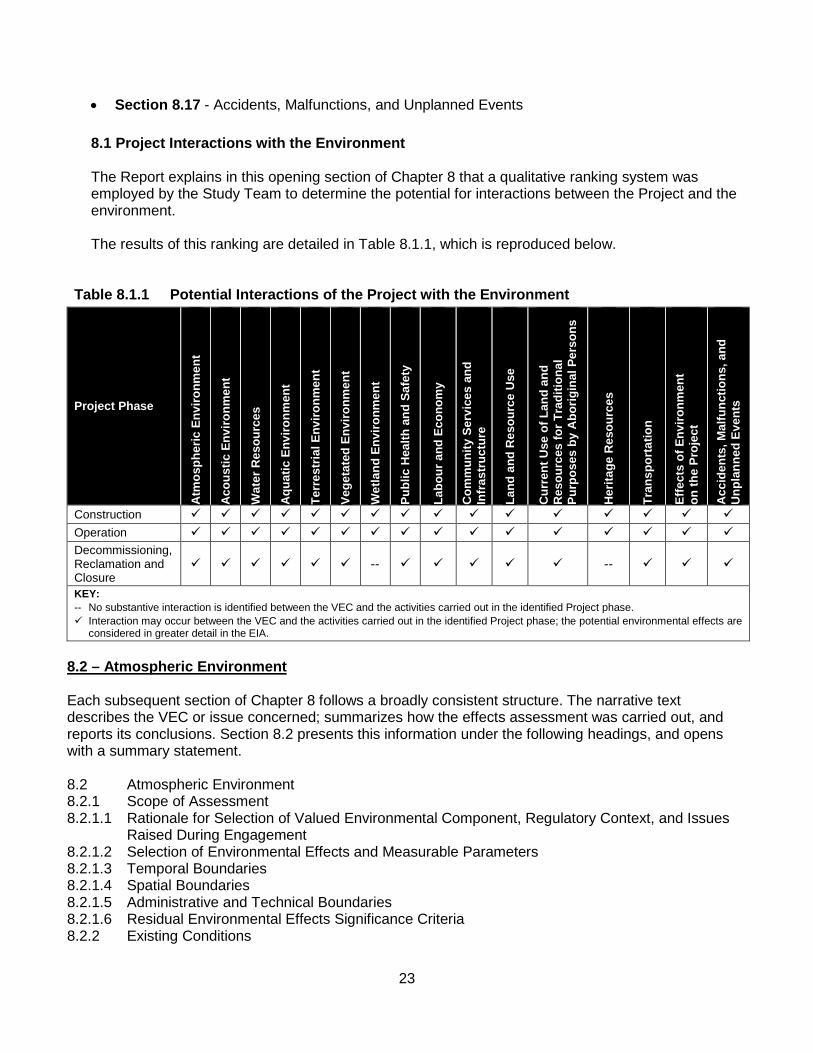
8.1 Project Interactions with the Environment The Report explains in this opening section of Chapter 8 that a qualitative ranking system was employed by the Study Team to determine the potential for interactions between the Project and the environment. The results of this ranking are detailed in Table 8.1.1, which is reproduced below.
Table 8.1.1 Potential Interactions of the Project with the Environment
Project Phase
Atm
osph
eric
Env
ironm
ent
Aco
ustic
Env
ironm
ent
Wat
er R
esou
rces
Aqu
atic
Env
ironm
ent
Terr
estr
ial E
nviro
nmen
t
Vege
tate
d En
viro
nmen
t
Wet
land
Env
ironm
ent
Publ
ic H
ealth
and
Saf
ety
Labo
ur a
nd E
cono
my
Com
mun
ity S
ervi
ces
and
Infr
astr
uctu
re
Land
and
Res
ourc
e U
se
Cur
rent
Use
of L
and
and
Res
ourc
es fo
r Tra
ditio
nal
Purp
oses
by
Abo
rigin
al P
erso
ns
Her
itage
Res
ourc
es
Tran
spor
tatio
n
Effe
cts
of E
nviro
nmen
t on
the
Proj
ect
Acc
iden
ts, M
alfu
nctio
ns, a
nd
Unp
lann
ed E
vent
s
Construction Operation Decommissioning, Reclamation and Closure
-- --
KEY: -- No substantive interaction is identified between the VEC and the activities carried out in the identified Project phase. Interaction may occur between the VEC and the activities carried out in the identified Project phase; the potential environmental effects are
considered in greater detail in the EIA.
8.2 – Atmospheric Environment Each subsequent section of Chapter 8 follows a broadly consistent structure. The narrative text describes the VEC or issue concerned; summarizes how the effects assessment was carried out, and reports its conclusions. Section 8.2 presents this information under the following headings, and opens with a summary statement. 8.2 Atmospheric Environment 8.2.1 Scope of Assessment 8.2.1.1 Rationale for Selection of Valued Environmental Component, Regulatory Context, and Issues
Raised During Engagement 8.2.1.2 Selection of Environmental Effects and Measurable Parameters 8.2.1.3 Temporal Boundaries 8.2.1.4 Spatial Boundaries 8.2.1.5 Administrative and Technical Boundaries 8.2.1.6 Residual Environmental Effects Significance Criteria 8.2.2 Existing Conditions
24
8.2.2.1 Climate 8.2.2.2 Ambient Air Quality 8.2.2.2.1 Provincial Ambient Air Quality Monitoring 8.2.2.2.2 Ambient Air Quality Monitoring Within the LAA 8.2.2.3 Air Contaminant and GHG Emissions 8.2.3 Potential Project-VEC Interactions 8.2.4 Assessment of Project-Related Environmental Effects 8.2.4.1 Potential Project Environmental Effects Mechanisms 8.2.4.2 Mitigation of Project Environmental Effects 8.2.4.3 Characterization of Residual Project Environmental Effects 8.2.4.3.1 Air Quality 8.2.4.3.2 Greenhouse Gas Emissions 8.2.5 Assessment of Cumulative Environmental Effects 8.2.6 Determination of Significance 8.2.6.1 Residual Project Environmental Effects 8.2.6.2 Residual Cumulative Environmental Effects 8.2.7 Follow-up of Monitoring Summary Statement - Atmospheric Environment
The opening summary statement for Section 8.2 begins on Page 8-5. It defines the Atmospheric Environment as a component of the environment that comprises the layer of air near the earth’s surface to a height of approximately 10 km.
It notes that the Atmospheric Environment was selected as a VEC for this EIA, because a healthy atmosphere helps sustain life and maintain the health and well-being of the biophysical environment. If not properly managed, the Report states that releases of air contaminants, including greenhouse gases (GHGs), to the atmosphere could cause adverse environmental effects on the air, the land and the waterways, and on the interacting biological systems that depend on them in the vicinity of the Project.
The Report states that Changes to the Atmospheric Environment during Construction, Operation, and Decommissioning, Reclamation and Closure of the Project might occur due to emissions from the Project components during each phase. These include emissions from heavy equipment used on-site, trucks used to deliver equipment and materials to the site, processing plant sources, fugitive emission sources, as well as passenger and heavy-duty vehicles.
It notes that these sources generate emissions such as particulate matter, combustion gases, and GHGs. Blasting; the movement of ore and rock, and wind erosion of exposed ground surfaces might also release particulate matter in the form of fugitive dust.
The Report explains that the environmental effects assessment of the Atmospheric Environment focused on a 25 km x 25 km area centred on the Project site. It notes that, within this Local Assessment Area (LAA) there are recreational campsites (located approximately 1.5 km southeast of the location of the open pit for the Project) and permanent residences (located in Napadogan approximately 10 km to the northeast of the Project). The Report notes that existing (baseline) conditions for the Atmospheric Environment were based on published data from Environment Canada and NBDELG, as well as a Project-specific baseline air quality monitoring campaign conducted in the LAA.

25
The study process used an air contaminant and GHG emissions inventory developed for the Construction and Operation phases, as these phases are likely to generate the highest emissions of air contaminants and GHGs during the Project life. The environmental effects assessment relied on the emissions inventory and associated dispersion modelling of specific air contaminants, selected due to the magnitude of those emissions, or because those contaminants are of ecological interest for both Construction and Operation. The Report explains that dispersion modelling provides predictions of ground-level concentrations and deposition of contaminants used to evaluate changes in the Atmospheric Environment. To evaluate the significance of these predicted changes, the results of the modelling were compared to objectives, guidelines and standards for the air contaminants of interest. Dispersion modelling results showed that during both Construction and Operation, ambient air quality standards and objectives are not expected to be exceeded at the nearest populated areas, such as the recreational campsites or at further distances such as the community of Napadogan. The Project might cause the ambient concentrations of total particulate matter (PM) and particulate matter less than 10 microns (PM10), but not less than 2.5 microns (PM2.5), to exceed ambient air quality objectives used in the EIA to assess potential environmental effects near the off-site access roads for the Project. These exceedances would be the result of road dust generation from Project-related traffic travelling on these unpaved roads, in a manner similar to dust levels from existing traffic on such roads today. The Report points out that these off-site access roads are located in remote wooded areas where relatively few human receptors would be exposed to such dust. Any ambient concentrations in excess of those objectives would be expected to be localized within a few hundred metres of the roads, infrequent, and of short duration. Dusty conditions near the primary crusher for the Project during Operation might also cause the ambient 24-hour PM objective to be infrequently exceeded. The Report states that ambient hydrogen sulphide (H2S) concentrations from the production of ammonium paratungstate (APT) might exceed the 10-minute odour threshold during Operation near the ore processing plant within the PDA. However, the occurrence of these levels would be infrequent and limited to a small area within 20 m of the ore processing plant. No perceivable odour is anticipated beyond 20 m from the ore processing plant. The estimated GHG emissions from Operation would be considered low (less than 50,000 tonnes of carbon dioxide equivalent (CO2e) per year), and similar in magnitude and GHG intensity to other metal mines in Canada. The summary statement for Section 8.2 concludes by stating that, given these observations, and as demonstrated by the analyses, with the proposed mitigation and environmental protection measures, the residual environmental effects of a Change in Atmospheric Environment during all phases of the Project would not be significant.
The Report states that monitoring of fuel combustion volumes in Project-related stationary and mobile equipment would be proposed to evaluate whether federal GHG reporting thresholds are reached. It also notes that monitoring programs for ambient air quality during Operation might be a requirement of a NBDELG-issued Certificate to Approval to Construct or Operate.
26
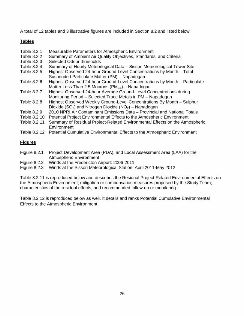
A total of 12 tables and 3 illustrative figures are included in Section 8.2 and listed below: Tables Table 8.2.1 Measurable Parameters for Atmospheric Environment Table 8.2.2 Summary of Ambient Air Quality Objectives, Standards, and Criteria Table 8.2.3 Selected Odour thresholds Table 8.2.4 Summary of Hourly Meteorlogical Data – Sisson Meteorological Tower Site Table 8.2.5 Highest Observed 24-hour Ground-Level Concentrations by Month – Total
Suspended Particulate Matter (PM) – Napadogan Table 8.2.6 Highest Observed 24-hour Ground-Level Concentrations by Month – Particulate
Matter Less Than 2.5 Mocrons (PM2.5) – Napadogan Table 8.2.7 Highest Observed 24-hour Average Ground-Level Concentrations during
Monitoring Period – Selected Trace Metals in PM – Napadogan Table 8.2.8 Highest Observed Weekly Ground-Level Concentrations By Month – Sulphur
Dioxide (SO2) and Nitrogen Dioxide (NO2) – Napadogan Table 8.2.9 2010 NPRI Air Contaminant Emissions Data – Provincial and National Totals Table 8.2.10 Potential Project Environmental Effects to the Atmospheric Environment Table 8.2.11 Summary of Residual Project-Related Environmental Effects on the Atmospheric
Environment Table 8.2.12 Potential Cumulative Environmental Effects to the Atmospheric Environment Figures Figure 8.2.1 Project Development Area (PDA), and Local Assessment Area (LAA) for the
Atmospheric Environment Figure 8.2.2 Winds at the Fredericton Airport: 2006-2011 Figure 8.2.3 Winds at the Sisson Meteorological Station: April 2011-May 2012 Table 8.2.11 is reproduced below and describes the Residual Project-Related Environmental Effects on the Atmospheric Environment; mitigation or compensation measures proposed by the Study Team; characteristics of the residual effects, and recommended follow-up or monitoring. Table 8.2.12 is reproduced below as well. It details and ranks Potential Cumulative Environmental Effects to the Atmospheric Environment.

27
Table 8.2.11 Summary of Residual Project-Related Environmental Effects on the Atmospheric Environment
Potential Residual Project-Related Environmental Effects
Project Phases, Activities, and
Physical Works Mitigation / Compensation
Measures
Residual Environmental Effects Characteristics
Sign
ifica
nce
Pred
ictio
n C
onfid
ence
Like
lihoo
d C
umul
ativ
e En
viro
nmen
tal
Effe
cts?
Recommended Follow-up or Monitoring
Dire
ctio
n
Mag
nitu
de
Geo
grap
hic
Exte
nt
Dur
atio
n an
d Fr
eque
ncy
Rev
ersi
bilit
y
Ecol
ogic
al/
Soci
oeco
nom
ic
Con
text
Change in Atmospheric Environment
Construction Emissions and
Wastes.
Implementation of idling reduction program.
Application of water on the site access road and on-site roads within the PDA (but not on forest resource roads) as required to reduce dust generation.
Seeding and re-vegetation of topsoil and overburden storage piles as soon as possible after disturbance.
Implementation of equipment and vehicle maintenance program to improve operational efficiency and reduce emissions.
A L L MT/C
R U N H -- Y • No follow-up recommended.
• Conduct ambient particulate monitoring, if complaints are received.
• Comply with Approval to Construct monitoring requirements.
Operation Emissions and
Wastes.
All mitigation mentioned under Construction above.
Use of dust collection systems on the primary crusher and within the ore processing plant, and partial covering of ore conveyors.
Use of H2S and NH3 scrubbers on APT plant.
A M L LT/C R U N H -- Y • No follow-up recommended.
• Conduct ambient particulate monitoring, if complaints are received.
• Comply with Approval to Operate monitoring requirements.
• Record the volumes of fuel consumed in stationary and mobile equipment, as well as electricity consumption.
• Estimate direct GHG emissions for

28
Table 8.2.11 Summary of Residual Project-Related Environmental Effects on the Atmospheric Environment
Potential Residual Project-Related Environmental Effects
Project Phases, Activities, and
Physical Works Mitigation / Compensation
Measures
Residual Environmental Effects Characteristics
Sign
ifica
nce
Pred
ictio
n C
onfid
ence
Like
lihoo
d C
umul
ativ
e En
viro
nmen
tal
Effe
cts?
Recommended Follow-up or Monitoring
Dire
ctio
n
Mag
nitu
de
Geo
grap
hic
Exte
nt
Dur
atio
n an
d Fr
eque
ncy
Rev
ersi
bilit
y
Ecol
ogic
al/
Soci
oeco
nom
ic
Con
text
comparison with reporting threshold.
Decommissioning, Reclamation and Closure
Residual Environmental Effects for all Phases
N H -- Y
KEY Direction P Positive. A Adverse. Magnitude L Low: Air Quality is not affected or
slightly affected but is well below objectives, guidelines, or standards; GHG Emissions < 50,000 t CO2e/a.
M Medium: Air Quality is affected to values that are near but largely below the objectives, guidelines, or standards; GHG Emissions < 500,000 but > 50,000 t CO2e/a.
H High: Air Quality is degraded to values that may substantially exceed objectives, guidelines, or standards; GHG Emissions > 500,000 t CO2e/a.
Geographic Extent S Site-specific: Within the PDA. L Local: Within the LAA. R Regional: Within the RAA.
Duration ST Short-term: Occurs and lasts for
short periods (e.g., days/weeks).
MT Medium-term: Occurs and lasts for extended periods of time (e.g., years).
LT Long-term: Occurs during Construction and/or Operation and lasts for the life of Project.
P Permanent: Occurs during Construction and Operation and beyond.
Frequency O Occurs once. S Occurs sporadically at irregular
intervals. R Occurs on a regular basis and at
regular intervals. C Continuous.
Reversibility R Reversible. I Irreversible. Ecological/Socioeconomic
Context U Undisturbed: Area relatively or
not adversely affected by human activity.
D Developed: Area has been substantially previously disturbed by human development or human development is still present.
N/A Not Applicable. Significance S Significant. N Not Significant.
Prediction Confidence Confidence in the significance prediction, based on scientific information and statistical analysis, professional judgment and known effectiveness of mitigation: L Low level of confidence. M Moderate level of confidence. H High level of confidence. Likelihood If a significant environmental effect is predicted, the likelihood of that significant environmental effect occurring, based on professional judgment: L Low probability of occurrence. M Medium probability of occurrence. H High probability of occurrence. Cumulative Environmental Effects? Y Potential for environmental effect to interact with the
environmental effects of other past, present or foreseeable projects or activities in RAA.
N Environmental effect will not or is not likely to interact with the environmental effects of other past, present or

29
Table 8.2.11 Summary of Residual Project-Related Environmental Effects on the Atmospheric Environment
Potential Residual Project-Related Environmental Effects
Project Phases, Activities, and
Physical Works Mitigation / Compensation
Measures
Residual Environmental Effects Characteristics
Sign
ifica
nce
Pred
ictio
n C
onfid
ence
Like
lihoo
d C
umul
ativ
e En
viro
nmen
tal
Effe
cts?
Recommended Follow-up or Monitoring
Dire
ctio
n
Mag
nitu
de
Geo
grap
hic
Exte
nt
Dur
atio
n an
d Fr
eque
ncy
Rev
ersi
bilit
y
Ecol
ogic
al/
Soci
oeco
nom
ic
Con
text
foreseeable projects or activities in RAA.

30
Table 8.2.12 Potential Cumulative Environmental Effects to the Atmospheric Environment
Other Projects or Activities With Potential for Cumulative Environmental Effects
Potential Cumulative Environmental Effects Change in Atmospheric Environment
Past or Present Projects or Activities That Have Been Carried Out Industrial Land Use (Past or Present) 0 Forestry and Agricultural Land Use (Past or Present) 0 Current Use of Land and Resources for Traditional Purposes by Aboriginal Persons (Past or Present) 0
Recreational Land Use (Past or Present) 0 Residential Land Use (Past or Present) 0 Future Projects or Activities That Will Be Carried Out Industrial Land Use (Future) 1 Forestry and Agricultural Land Use (Future) 1 Current Use of Land and Resources for Traditional Purposes by Aboriginal Persons (Future) 0
Recreational Land Use (Future) 0 Planned Residential Development (Future) 1 Cumulative Environmental Effects Notes: Cumulative environmental effects were ranked as follows: 0 Project environmental effects do not act cumulatively with those of other Projects and Activities. 1 Project environmental effects act cumulatively with those of other Project and Activities, but are unlikely to result in significant
cumulative environmental effects OR Project environmental effects act cumulatively with existing significant levels of cumulative environmental effects but will not measurably change the state of the VEC.
2 Project environmental effects act cumulatively with those of other project and activities, and may result in significant cumulative environmental effects OR Project environmental effects act cumulatively with existing significant levels of cumulative environmental effects and may measurably change the state of the VEC.

31
8.3 – Acoustic Environment The narrative text in this section describes the VEC concerned; summarizes how the effects assessment was carried out, and reports its conclusions. Section 8.3 presents this information under the following headings, and opens with a summary statement. 8.3 Acoustic Environment 8.3.1 Scope of Assessment 8.3.1.1 Rationale for Selection of Valued Environmental Component, Regulatory Context, and Issues During Engagement 8.3.1.2 Selection of Environmental Effect and Measurable Parameters 8.3.1.3 Temporal Boundaries 8.3.1.4 Spatial Boundaries 8.3.1.5 Administrative and Technical Boundaries 8.3.1.6 Residual Environmental Effects Significance Criteria 8.3.2 Existing Conditions 8.3.3 Potential Project-VEC Interactions 8.3.4 Assessment of Project-Related Environmental Effects 8.3.4.1 Potential Project Environmental Effects Mechanisms 8.3.4.2 Mitigation of Project Environmental Effects 8.3.4.3 Characterization of Residual project Environmental Effects 8.3.5 Assessment of Cumulative Environmental Effects 8.3.6 Determination of Significance 8.3.6.1 Residual Project Environmental Effects 8.3.6.2 Residual Cumulative Environmental Effects 8.3.7 Follow-up or Monitoring
Summary Statement – Acoustic Environment
The opening summary statement for Section 8.3 begins on Page 8-37. It states that the Project might adversely affect the Acoustic Environment, including sound quality in the outdoor environment. It notes that the emission of sound waves from natural and manmade sources; their propagation through the atmosphere, and their detection through auditory or other means at a noise sensitive receptor in the ambient environment, characterize sound quality. The Project could affect sound quality near the Project, and therefore Acoustic Environment is a VEC for the EIA.
The Report notes that there is also potential for Project activities to generate vibration in the immediate vicinity of the Project that, if excessive, could be objectionable or cause property damage. Thus, for the purpose of this VEC, the Acoustic Environment also includes Project-related vibration that could affect nearby human receptors to the Project.
The Report states that sound and vibration emissions could be generated from heavy equipment; drilling and blasting of ore and rock; transportation of personnel, materials, and products; crushing and conveying equipment; and processing equipment. It notes that the assessment of the Acoustic Environment centred on the PDA and extended out to 10 km in order to encompass the nearest permanent residential receptor in Napadogan.
Sound pressure level monitoring for a period of one week near the Project provided conservative existing baseline conditions for the environmental effects assessment. The Report explains that sound pressure

32
levels and vibration during Construction and Operation would likely generate the highest sound and vibration levels during the Project life. Modelling of Project-related sound and vibration provided predicted sound pressure and vibration levels at both the nearest noise sensitive receptors (i.e., recreational campsites) and nearest permanent residences, for comparison with objectives and standards.
The sound emissions estimates and sound pressure level monitoring showed that, with the exception of sound emissions from blasting events, activities during Construction and Operation would not be expected to be noticeable at the nearest residential receptor in Napadogan, nor more proximally at the nearest recreational campsite.
The Report also notes there was no predicted change in the measurable parameter of ‘percent highly annoyed’, an indicator of disturbance for people, for Construction or Operation at either location. Estimated vibration levels from heavy equipment movements and the process operation showed that vibration would not be noticeable at the recreational campsites or at further distances, during either Construction or Operation.
The Report notes that there is potential for occupants of the nearest recreational campsite to perceive vibration during a blasting event; however, the period would be brief and the vibration amplitude small (similar to the vibration caused by a large bulldozer operating 7.6 m away from a receptor).
The summary statement for Section 8.3 concludes by stating that, as demonstrated by the analyses, with the proposed mitigation and environmental protection measures, the residual environmental effects of a Change in the Acoustic Environment during all phases of the Project would be not significant, and no follow-up is proposed.
A total of 8 tables and 5 illustrative figures are included in Section 8.3 and listed below: Tables Table 8.3.1 Measurable Parameters for the Acoustic Environment Table 8.3.2 Baseline Sound Monitoring Locations and Dates Table 8.3.3 Baseline Sound Pressure Level Monitoring Results – 1-h Leq Table 8.3.4 Baseline Sound Pressure Level Monitoring Results – 24-h Leq Table 8.3.5 Baseline Sound Pressure Level Monitoring Results - LDN Table 8.3.6 Potential Project Environmental Effects to the Acoustic Environment Table 8.3.7 Summary of Residual Project-Related Environmental Effects on the Acoustic Environment Table 8.3.8 Potential Cumulative Environmental Effects to the Acoustic Environment Figures Figure 8.3.1 Local Assessment Area (LAA) and Regional Assessment Area (RAA) for Acoustic Environment Figure 8.3.2 Baseline Sound Pressure Level Monitoring Locations Figure 8.3.3 Baseline Sound Pressure Levels at Meteorological Station (Monitoring Site 1) – 1-h Leq (October 20 to October 27, 2011) Figure 8.3.4 Baseline Sound Pressure Levels at Four Mile Brook Road (Monitoring Site 2) – 1-h Leq (November 3 to November 10, 2011)

33
Figure 8.3.5 Baseline Sound Pressure Levels at Recreational Campsite (Monitoring Site 3) – 1-h Leq (October 6 to October 13, 2011) Table 8.3.7 is reproduced below and summarizes the Residual Project-Related Environmental Effects on the Acoustic Environment; mitigation or compensation measures proposed by the Study Team; characteristics of the residual effects, and recommended follow-up or monitoring. Table 8.3.8 is reproduced below as well. It details and ranks Potential Cumulative Environmental Effects to the Acoustic Environment.

34
Table 8.3.7 Summary of Residual Project-Related Environmental Effects on the Acoustic Environment
Potential Residual Project-Related Environmental Effects
Project Phases, Activities, and
Physical Works Mitigation / Compensation
Measures
Residual Environmental Effects Characteristics
Sign
ifica
nce
Pred
ictio
n C
onfid
ence
Like
lihoo
d
Cum
ulat
ive
Envi
ronm
enta
l Effe
cts
Recommended Follow-up or Monitoring
Dire
ctio
n
Mag
nitu
de
Geo
grap
hic
Exte
nt
Dur
atio
n an
d Fr
eque
ncy
Rev
ersi
bilit
y
Ecol
ogic
al/
Soci
oeco
nom
ic
Con
text
Change in the Acoustic Environment
Construction • Emissions and
Wastes.
• Implement an idling reduction policy.
• Limit construction activity to daytime hours where feasible.
• Limit blasting activity to daytime hours only, where feasible, and minimize the frequency of blasts.
• Complete drilling and blasting events during daytime hours only whenever feasible, and minimize the frequency of blasts.
• Use of mufflers. • Ensure equipment is properly
maintained.
A M L MT/R
R D N H -- Y If noise complaints are received, sound monitoring may be conducted and activities modified to reduce noise. Comply with Approval to Construct monitoring requirements.
Operation • Emissions and
Wastes.
• Complete drilling and blasting events during daytime hours only whenever feasible, and minimize the frequency of blasts.
• Notify nearby residents and camp owners of the blasting schedule.
• Implementation of an idling reduction policy.
• Routine trucking during daytime time hours only.
• Carry out preventative maintenance on equipment Processing equipment enclosed in buildings.
• Partially enclosed primary crusher and conveyors.
A M L/R
LT/R
R D N H -- Y Conduct sound and vibration monitoring at the nearest recreational campsite to confirm the estimated sound and vibration levels. Comply with Approval to Operate monitoring requirements. If noise complaints are received, sound monitoring may be conducted and activities modified to reduce noise.
Decommissioning,

35
Table 8.3.7 Summary of Residual Project-Related Environmental Effects on the Acoustic Environment
Potential Residual Project-Related Environmental Effects
Project Phases, Activities, and
Physical Works Mitigation / Compensation
Measures
Residual Environmental Effects Characteristics
Sign
ifica
nce
Pred
ictio
n C
onfid
ence
Like
lihoo
d
Cum
ulat
ive
Envi
ronm
enta
l Effe
cts
Recommended Follow-up or Monitoring
Dire
ctio
n
Mag
nitu
de
Geo
grap
hic
Exte
nt
Dur
atio
n an
d Fr
eque
ncy
Rev
ersi
bilit
y
Ecol
ogic
al/
Soci
oeco
nom
ic
Con
text
Reclamation and Closure
Residual Environmental Effects for all Phases
N H -- Y
KEY Direction P Positive. A Adverse. Magnitude L Low: Sound pressure levels at or below
background, vibration below detection threshold.
M Medium: Sound pressure levels above background but below noise guideline level, vibration noticeable but not causing annoyance or structural damage.
H High: Sound pressure levels exceed noise guideline level, vibration is disturbing to nearest receptors or causes structural damage.
Geographic Extent S Site-specific: Within the PDA. L Local: Within the LAA. R Regional: Within the RAA.
Duration ST Short term: Occurs and lasts for
short periods (e.g., days/weeks). MT Medium term: Occurs and lasts for
extended periods of time (e.g., years).
LT Long term: Occurs during Construction and/or Operation and lasts for the life of Project.
P Permanent: Occurs during Construction and Operation and beyond.
Frequency O Occurs once. S Occurs sporadically at irregular
intervals. R Occurs on a regular basis and at
regular intervals. C Continuous.
Reversibility R Reversible. I Irreversible. Ecological/Socioeconomic Context U Undisturbed: Area relatively or not
adversely affected by human activity.
D Developed: Area has been substantially previously disturbed by human development or human development is still present.
N/A Not Applicable. Significance S Significant. N Not Significant.
Prediction Confidence Confidence in the significance prediction, based on scientific information and statistical analysis, professional judgment and known effectiveness of mitigation: L Low level of confidence. M Moderate level of confidence. H High level of confidence. Likelihood If a significant environmental effect is predicted, the likelihood of that significant environmental effect occurring, based on professional judgment: L Low probability of occurrence. M Medium probability of occurrence. H High probability of occurrence. Cumulative Environmental Effects? Y Potential for environmental effect to interact with
the environmental effects of other past, present, or foreseeable projects or activities in RAA.
N Environmental effect will not or is not likely to interact with the environmental effects of other past, present or foreseeable projects or activities in RAA.

36
Table 8.3.8 Potential Cumulative Environmental Effects to the Acoustic Environment
Other Projects or Activities With Potential for Cumulative Environmental Effects
Potential Cumulative Environmental Effects Change in the Acoustic Environment
Past or Present Projects or Activities That Have Been Carried Out Industrial Land Use (Past or Present) 0 Forestry and Agricultural Land Use (Past or Present) 1 Current Use of Land and Resources for Traditional Purposes by Aboriginal Persons (Past or Present) 1
Recreational Land Use (Past or Present) 1 Residential Land Use (Past or Present) 1 Potential Future Projects or Activities That Will Be Carried Out Industrial Land Use (Future) 1 Forestry and Agricultural Land Use (Future) 1 Current Use of Land and Resources for Traditional Purposes by Aboriginal Persons (Future) 1
Recreational Land Use (Future) 1 Planned Residential Development (Future) 1 Cumulative Environmental Effects Notes: Cumulative environmental effects were ranked as follows: 0 Project environmental effects do not act cumulatively with those of other Projects and Activities. 1 Project environmental effects act cumulatively with those of other Project and Activities, but are unlikely to result in
significant cumulative environmental effects OR Project environmental effects act cumulatively with existing significant levels of cumulative environmental effects but will not measurably change the state of the VEC.
2 Project environmental effects act cumulatively with those of other project and activities, and may result in significant cumulative environmental effects OR Project environmental effects act cumulatively with existing significant levels of cumulative environmental effects and may measurably change the state of the VEC.
8.4 – Water Resources This section’s narrative text describes the VEC concerned; summarizes how the effects assessment was carried out, and reports its conclusions. Section 8.4 presents this information under the following headings, and opens with a summary statement. 8.4 Water Resources 8.4.1 Scope of Assessment 8.4.1.1 Rationale for Selection of Valued Environmental Component, Regulatory Context, and Issues Raised During Engagement 8.4.1.2 Selection of Environmental Effect and Measurable Parameters 8.4.1.3 Temporal Boundaries 8.4.1.4 Spatial Boundaries 8.4.1.5 Administrative and Technical Boundaries 8.4.1.6 Residual Environmental Effects Significance Criteria 8.4.2 Existing Conditions 8.4.2.1 Climate and Water Resources 8.4.2.1.1 Precipitation Analysis 8.4.2.1.2 Extreme Precipitation 8.4.2.1.3 Environmental Water Balance 8.4.2.2 Hydrological Conditions 8.4.2.2.1 Watershed Delineation 8.4.2.2.2 Stream Flow 8.4.2.2.3 Surface Water Quality

37
8.4.2.2.4 Surface Water Users 8.4.2.3 Groundwater 8.4.2.3.1 Bedrock Geology 8.4.2.3.2 Surficial Geology 8.4.2.3.3 Hydrogeologic Setting 8.4.2.3.4 Groundwater Quality 8.4.2.3.5 Groundwater Users 8.4.3 Potential Project-VEC Interactions 8.4.3.1 Construction 8.4.3.2 Operation 8.4.3.3 Decommissioning, Reclamation and Closure 8.4.4 Assessment of Project-Related Environmental Effects 8.4.4.1 Potential project Environmental Effects Mechanisms 8.4.4.1.1 Construction: Physical Construction and Installation of Project Facilities 8.4.4.1.2 Operation: Mine Waste and Water Management 8.4.4.1.3 Decommissioning, Reclamation and Closure 8.4.4.2 Mitigation of Project Environmental Effects 8.4.4.3 Characterization of Residual Project Environmental Effects 8.4.4.3.1 Construction 8.4.4.3.2 Operation 8.4.4.3.3 Decommissioning, Reclamation and Closure 8.4.5 Assessment of Cumulative Environmental Effects 8.4.6 Determination of Significance 8.4.6.1 Residual Project Environmental Effects 8.4.6.2 Residual Cumulative Environmental Effects 8.4.7 Follow-up Monitoring Summary Statement – Water Resources
The opening summary statement for Section 8.4 begins on Page 8-61 and states that Water is essential for life on Earth. As a key resource for human and ecological life, it notes that changes in the availability of water, both in terms of the amount of water and the quality of the water, may affect the lives of people and other living things.
It notes that Water Resources were identified as a VEC because of the importance of this resource in providing potable water to users in the area surrounding the Project.
The Report also explains that Water Resources are closely linked to other VECs. These include the Aquatic Environment (as a resource for fish and aquatic life); Terrestrial Environment (as a resource for wildlife); Vegetated Environment (as a resource for plants); Wetland Environment (as habitat for plants, animals, communities and for hydrological function), as well as Land and Resource Use (as a resource for humans).
It notes that the use of water as a resource for human use, and by extension for all living things, is assessed in Section 8.4 with particular emphasis placed on the use of water as a resource for human consumption.
The Report states that the Project would interact with Water Resources in the following ways:

38
• Alterations to some watercourses during Construction, either through elimination of portions of those watercourses to construct the Project facilities, or through re-routing or diversion of water around Project facilities, would result in a local re-distribution of water resources.
• Dewatering of the open pit during Operation would result in localized lowering of the water table, possibly affecting surface water hydrology and nearby well users (if any are present).
• Sequestration of mine contact and process water within the tailings voids in the tailings storage facility (TSF) during Operation, filling of the open pit during Closure, and evaporation from the TSF pond and the eventual pit lake Post-Closure, would reduce the amount of surface water (and thus groundwater) available for possible human consumption.
• Discharges of surplus water (beyond Project needs), and seepage through or beneath the TSF embankments, might affect groundwater or surface water quality, if not adequately contained or treated to acceptable standards prior entering the receiving environment.
As demonstrated in the assessment, the Report states the environmental effects of the Project on Water Resources would not be significant because:
• the environmental effects of watercourse alterations on surface water hydrology would be mitigated and authorized under provincial and federal regulation;
• virtually all of the water requirements for the Project would be met by the reuse of water collected on-site, and recycled through the TSF;
• the collection of mine contact and process water in the TSF during Operation, and in the pit lake during Closure, would not adversely affect downstream surface water use or groundwater use;
• discharge of surplus water from the Project would be treated (as necessary) to acceptable discharge standards prior to release; and
• the design and management of the TSF would ensure that seepage through the TSF embankments would not affect downstream groundwater and surface water quality to an extent that it causes an exceedance of Health Canada’s “Guidelines for Canadian Drinking Water Quality” that would adversely affect human health.
Portions of watercourses and watersheds within the PDA would be permanently eliminated to make way for the open pit, TSF, and associated Project facilities, particularly Bird and Sisson brooks and a small unnamed tributary (known as Tributary “A”), to West Branch Napadogan Brook.
Later during Operation, fingertip portions of McBean Brook near the open pit might also be affected, either directly or indirectly.
The Report states that the elimination of substantial portions of these watercourses and various Project-related diversions and consumptions would result in a re-distribution of water resources in these

39
watersheds. The watercourse alterations would be conducted under an authorization under the Fisheries Act and a permit under the Watercourse and Wetland Alteration Regulation. The affected watercourses and watersheds are tributary to the larger Napadogan Brook and Nashwaak River watersheds.
The Report explains that, although some mine contact water falling onto the PDA as precipitation and run-off would be sequestered in the TSF during Operation, and in the open pit during Closure, thereby resulting in a reduction of flows in these headwaters, minimal long-term reductions to flows within the downstream Napadogan Brook or the Nashwaak River watershed as a whole would result from these alterations and sequestration. No large surface water users for human consumption were identified on Napadogan Brook, and therefore, the reductions are not anticipated to affect surface water availability for potential users.
Groundwater seepage and precipitation into the open pit would be periodically removed from the pit using conventional (pit sump) dewatering approaches. This would result in the lowering of the water table and affect the availability of groundwater up to 2 km from the open pit. However, the closest known residential well users as identified by NBDELG are located more than 9 km from the open pit in Napadogan.
The Report notes that other potential groundwater users, including recreational campsites, are located more than 1.5 km from the open pit, and are not expected to be affected by pit dewatering, as these water supplies are likely local shallow groundwater beyond the zone of influence of the open pit drawdown. There are no known plans for surface water or groundwater use within the zone of influence of the open pit or the PDA itself, except for the mine fresh water supply. The Report explains that this fresh potable water supply would be sited and developed in consideration of the potential zone of influence of the Project, and other users are too far removed from the Project to be of concern from a human consumption perspective.
During Operation, the water from open pit dewatering would be directed to a water management pond to the north of the pit, and then to the TSF for use in the Project. Water surplus to Project needs would be drawn from the TSF, clarified and treated before release to the receiving environment in the lower Sisson Brook above its confluence with Napadogan Brook, such that downstream water quality would not adversely affect existing users.
During Post-Closure of the Project, similar treatment of the pit lake water would be undertaken before discharge for as long as necessary, to ensure downstream water quality objectives are met. The bulk of the water requirements for ore processing would be derived from reclaiming mine contact water collected in the TSF, and subsequently discharged back to the TSF following clarification and use in the process.
This would minimize the demand for fresh water for the Project; allow for a predictable water budget over the life of the Project, and minimize the requirement for discharge and treatment of mine-contact water, at least until approximately Year 7 of Operation.
Until that time, there would be no need for treatment and discharge of surplus water. Fresh water would be required for on-site potable water, sanitary facilities, fire suppression, watering of unpaved roads and exposed areas, and process make-up water. It would be supplied by on-site wells drilled for the Project,
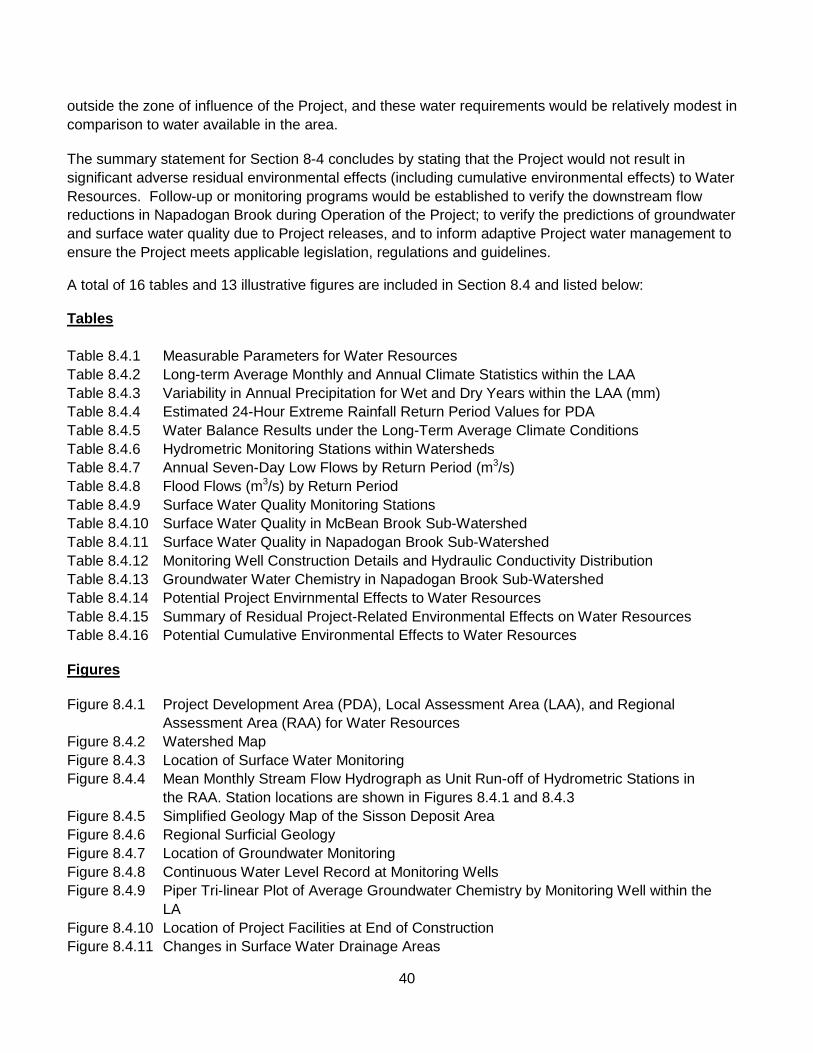
40
outside the zone of influence of the Project, and these water requirements would be relatively modest in comparison to water available in the area.
The summary statement for Section 8-4 concludes by stating that the Project would not result in significant adverse residual environmental effects (including cumulative environmental effects) to Water Resources. Follow-up or monitoring programs would be established to verify the downstream flow reductions in Napadogan Brook during Operation of the Project; to verify the predictions of groundwater and surface water quality due to Project releases, and to inform adaptive Project water management to ensure the Project meets applicable legislation, regulations and guidelines.
A total of 16 tables and 13 illustrative figures are included in Section 8.4 and listed below: Tables Table 8.4.1 Measurable Parameters for Water Resources Table 8.4.2 Long-term Average Monthly and Annual Climate Statistics within the LAA Table 8.4.3 Variability in Annual Precipitation for Wet and Dry Years within the LAA (mm) Table 8.4.4 Estimated 24-Hour Extreme Rainfall Return Period Values for PDA Table 8.4.5 Water Balance Results under the Long-Term Average Climate Conditions Table 8.4.6 Hydrometric Monitoring Stations within Watersheds Table 8.4.7 Annual Seven-Day Low Flows by Return Period (m3/s) Table 8.4.8 Flood Flows (m3/s) by Return Period Table 8.4.9 Surface Water Quality Monitoring Stations Table 8.4.10 Surface Water Quality in McBean Brook Sub-Watershed Table 8.4.11 Surface Water Quality in Napadogan Brook Sub-Watershed Table 8.4.12 Monitoring Well Construction Details and Hydraulic Conductivity Distribution Table 8.4.13 Groundwater Water Chemistry in Napadogan Brook Sub-Watershed Table 8.4.14 Potential Project Envirnmental Effects to Water Resources Table 8.4.15 Summary of Residual Project-Related Environmental Effects on Water Resources Table 8.4.16 Potential Cumulative Environmental Effects to Water Resources
Figures
Figure 8.4.1 Project Development Area (PDA), Local Assessment Area (LAA), and Regional Assessment Area (RAA) for Water Resources Figure 8.4.2 Watershed Map Figure 8.4.3 Location of Surface Water Monitoring Figure 8.4.4 Mean Monthly Stream Flow Hydrograph as Unit Run-off of Hydrometric Stations in the RAA. Station locations are shown in Figures 8.4.1 and 8.4.3 Figure 8.4.5 Simplified Geology Map of the Sisson Deposit Area Figure 8.4.6 Regional Surficial Geology Figure 8.4.7 Location of Groundwater Monitoring Figure 8.4.8 Continuous Water Level Record at Monitoring Wells Figure 8.4.9 Piper Tri-linear Plot of Average Groundwater Chemistry by Monitoring Well within the LA Figure 8.4.10 Location of Project Facilities at End of Construction Figure 8.4.11 Changes in Surface Water Drainage Areas

41
Figure 8.4.12 Stream Flow Alteration Throughout the Project Life as Percentage of Baseline Mean Annual Flow Figure 8.4.13 Limits of Potential Groundwater Drawdown from Open Pit Dewatering
Table 8.4.15 is reproduced below and summarizes the Residual Project-Related Environmental Effects on Water Resources; mitigation or compensation measures proposed by the Study Team; characteristics of the residual effects, and recommended follow-up or monitoring. Table 8.4.16 is reproduced below as well. It details and ranks Potential Cumulative Environmental Effects to Water Resources.
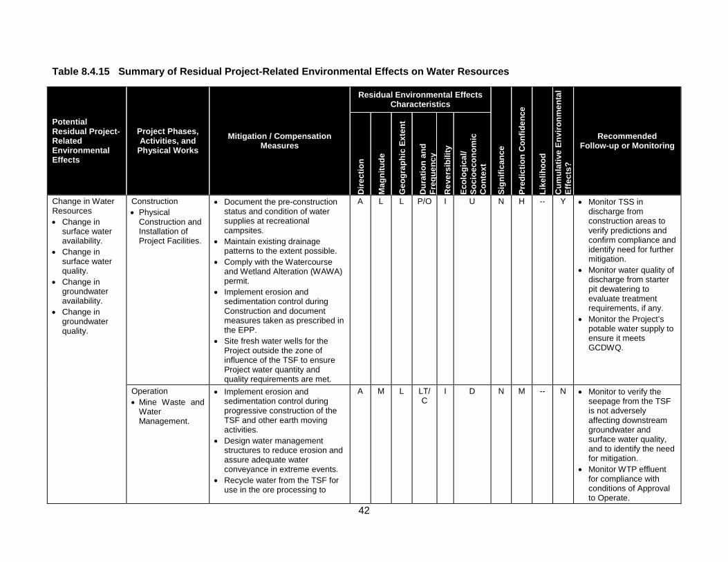
42
Table 8.4.15 Summary of Residual Project-Related Environmental Effects on Water Resources
Potential Residual Project-Related Environmental Effects
Project Phases, Activities, and
Physical Works Mitigation / Compensation
Measures
Residual Environmental Effects Characteristics
Sign
ifica
nce
Pred
ictio
n C
onfid
ence
Like
lihoo
d
Cum
ulat
ive
Envi
ronm
enta
l Ef
fect
s?
Recommended Follow-up or Monitoring
Dire
ctio
n
Mag
nitu
de
Geo
grap
hic
Exte
nt
Dur
atio
n an
d Fr
eque
ncy
Rev
ersi
bilit
y
Ecol
ogic
al/
Soci
oeco
nom
ic
Con
text
Change in Water Resources • Change in
surface water availability.
• Change in surface water quality.
• Change in groundwater availability.
• Change in groundwater quality.
Construction • Physical
Construction and Installation of Project Facilities.
• Document the pre-construction status and condition of water supplies at recreational campsites.
• Maintain existing drainage patterns to the extent possible.
• Comply with the Watercourse and Wetland Alteration (WAWA) permit.
• Implement erosion and sedimentation control during Construction and document measures taken as prescribed in the EPP.
• Site fresh water wells for the Project outside the zone of influence of the TSF to ensure Project water quantity and quality requirements are met.
A L L P/O I U N H -- Y • Monitor TSS in discharge from construction areas to verify predictions and confirm compliance and identify need for further mitigation.
• Monitor water quality of discharge from starter pit dewatering to evaluate treatment requirements, if any.
• Monitor the Project’s potable water supply to ensure it meets GCDWQ.
Operation • Mine Waste and
Water Management.
• Implement erosion and sedimentation control during progressive construction of the TSF and other earth moving activities.
• Design water management structures to reduce erosion and assure adequate water conveyance in extreme events.
• Recycle water from the TSF for use in the ore processing to
A M L LT/C
I D N M -- N • Monitor to verify the seepage from the TSF is not adversely affecting downstream groundwater and surface water quality, and to identify the need for mitigation.
• Monitor WTP effluent for compliance with conditions of Approval to Operate.
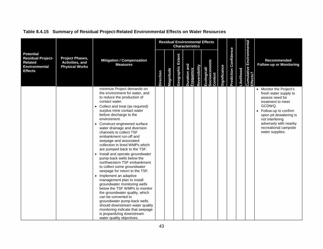
43
Table 8.4.15 Summary of Residual Project-Related Environmental Effects on Water Resources
Potential Residual Project-Related Environmental Effects
Project Phases, Activities, and
Physical Works Mitigation / Compensation
Measures
Residual Environmental Effects Characteristics
Sign
ifica
nce
Pred
ictio
n C
onfid
ence
Like
lihoo
d
Cum
ulat
ive
Envi
ronm
enta
l Ef
fect
s?
Recommended Follow-up or Monitoring
Dire
ctio
n
Mag
nitu
de
Geo
grap
hic
Exte
nt
Dur
atio
n an
d Fr
eque
ncy
Rev
ersi
bilit
y
Ecol
ogic
al/
Soci
oeco
nom
ic
Con
text
minimize Project demands on the environment for water, and to reduce the production of contact water.
• Collect and treat (as required) surplus mine contact water before discharge to the environment.
• Construct engineered surface water drainage and diversion channels to collect TSF embankment run-off and seepage and associated collection in lined WMPs which are pumped back to the TSF.
• Install and operate groundwater pump-back wells below the northwestern TSF embankment to collect some groundwater seepage for return to the TSF.
• Implement an adaptive management plan to install groundwater monitoring wells below the TSF WMPs to monitor the groundwater quality, which can be converted to groundwater pump-back wells should downstream water quality monitoring indicate that seepage is jeopardizing downstream water quality objectives.
• Monitor the Project’s fresh water supply to assess need for treatment to meet GCDWQ.
• Follow-up to confirm open pit dewatering is not interfering adversely with nearby recreational campsite water supplies.

44
Table 8.4.15 Summary of Residual Project-Related Environmental Effects on Water Resources
Potential Residual Project-Related Environmental Effects
Project Phases, Activities, and
Physical Works Mitigation / Compensation
Measures
Residual Environmental Effects Characteristics
Sign
ifica
nce
Pred
ictio
n C
onfid
ence
Like
lihoo
d
Cum
ulat
ive
Envi
ronm
enta
l Ef
fect
s?
Recommended Follow-up or Monitoring
Dire
ctio
n
Mag
nitu
de
Geo
grap
hic
Exte
nt
Dur
atio
n an
d Fr
eque
ncy
Rev
ersi
bilit
y
Ecol
ogic
al/
Soci
oeco
nom
ic
Con
text
• Construct engineered drainage and diversion channels to divert non-contact water around the Project facilities wherever possible.
Decommissioning, Reclamation and Closure • Closure.
• Flood the open pit during Closure to minimize the potential for metal leaching and acid rock drainage (ML/ARD) from remaining pit walls.
• Maintain ponded water over PAG tailings and waste rock within the TSF to effectively mitigate the potential for ML/ARD.
• As required, treat water released from Project following Closure, for as long as necessary to meet discharge water quality requirements.
• Post-Closure, maintain pit lake level to ensure it is a groundwater sink until water quality meets discharge conditions of the Approval to Operate.
A L L P/O R D N M -- Y • Monitor discharge from the TSF, and water in the open pit, to evaluate need for treatment before discharge to Sisson Brook.
Residual Environmental Effects for all Phases
N M -- Y

45
Table 8.4.15 Summary of Residual Project-Related Environmental Effects on Water Resources
Potential Residual Project-Related Environmental Effects
Project Phases, Activities, and
Physical Works Mitigation / Compensation
Measures
Residual Environmental Effects Characteristics
Sign
ifica
nce
Pred
ictio
n C
onfid
ence
Like
lihoo
d
Cum
ulat
ive
Envi
ronm
enta
l Ef
fect
s?
Recommended Follow-up or Monitoring
Dire
ctio
n
Mag
nitu
de
Geo
grap
hic
Exte
nt
Dur
atio
n an
d Fr
eque
ncy
Rev
ersi
bilit
y
Ecol
ogic
al/
Soci
oeco
nom
ic
Con
text
KEY Direction P Positive. A Adverse. Magnitude L Low: Environmental effect occurs that is
detectable but is within the normal variability of existing conditions.
M Medium: Environmental effect occurs that is larger than the normal variability of existing conditions but is within regulatory objectives or limits and restricted to the LAA.
H High: Environmental effect occurs that would singly or as a substantial contribution in combination with other sources may cause exceedance of objectives or regulatory limits within the LAA or RAA.
Geographic Extent S Site-specific: Within the PDA. L Local: Within the LAA. R Regional: Within the RAA.
Duration ST Short-term: Occurs and lasts
for short periods (e.g., days/weeks).
MT Medium-term: Occurs and lasts for extended periods of time (e.g., years).
LT Long-term: Occurs during Construction and/or Operation and lasts for the life of Project.
P Permanent: Occurs during Construction and Operation and beyond.
Frequency O Occurs once. S Occurs sporadically at irregular
intervals. R Occurs on a regular basis and at
regular intervals. C Continuous.
Reversibility R Reversible. I Irreversible. Ecological/Socioeconomic Context U Undisturbed: Area relatively or not
adversely affected by human activity.
D Developed: Area has been substantially previously disturbed by human development or human development is still present.
N/A Not Applicable. Significance S Significant. N Not Significant.
Prediction Confidence Confidence in the significance prediction, based on scientific information and statistical analysis, professional judgment and known effectiveness of mitigation: L Low level of confidence. M Moderate level of confidence. H High level of confidence. Likelihood If a significant environmental effect is predicted, the likelihood of that significant environmental effect occurring, based on professional judgment: L Low probability of occurrence. M Medium probability of occurrence. H High probability of occurrence. Cumulative Environmental Effects? Y Potential for environmental effect to interact with
the environmental effects of other past, present or foreseeable projects or activities in RAA.
N Environmental effect will not or is not likely to interact with the environmental effects of other past, present or foreseeable projects or activities in RAA.

46
Table 8.4.16 Potential Cumulative Environmental Effects to Water Resources
Other Projects or Activities With Potential for Cumulative Environmental Effects
Potential Cumulative Environmental Effects Change in Water Resources
Past or Present Projects or Activities That Have Been Carried Out Industrial Land Use (Past or Present) 0 Forestry and Agricultural Land Use (Past or Present) 1 Current Use of Land and Resources for Traditional Purposes by Aboriginal Persons (Past or Present) 0
Recreational Land Use (Past or Present) 0 Residential Land Use (Past or Present) 0 Potential Future Projects or Activities That Will Be Carried Out Industrial Land Use (Future) 0 Forestry and Agricultural Land Use (Future) 1 Current Use of Land and Resources for Traditional Purposes by Aboriginal Persons (Future) 0
Land Use (Future) Recreational 0
Planned Residential Development (Future) 0
Cumulative Environmental Effects Notes: Cumulative environmental effects were ranked as follows: 0 Project environmental effects do not act cumulatively with those of other projects or activities that have been or will be carried out. 1 Project environmental effects act cumulatively with those of other projects or activities that have been or will be carried out, but are
unlikely to result in significant cumulative environmental effects; or Project environmental effects act cumulatively with existing significant levels of cumulative environmental effects but will not measurably change the state of the VEC.
2 Project environmental effects act cumulatively with those of other projects or activities that have been or will be carried out, and may result in significant cumulative environmental effects; or Project environmental effects act cumulatively with existing significant levels of cumulative environmental effects and may measurably change the state of the VEC.
8.5. – Aquatic Environment This section’s narrative text describes the VEC concerned; summarizes how the effects assessment was carried out, and reports its conclusions. Section 8.5 presents this information under the following headings, and opens with a summary statement: 8.5 Aquatic Environment 8.5.1 Scope of Assessment 8.5.1.1 Rationale for Selection of Valued Environmental Component, Regulatory Context, and Issues Raised During Engagement 8.5.1.2 Selection of Environmental Effect and Measurable Parameters 8.5.1.3 Temporal Boundaries 8.5.1.4 Spatial Boundaries 8.5.1.5 Administrative and Technical Boundaries 8.5.1.5.1 Administrative Boundaries 8.5.1.5.2 Technical Boundaries 8.5.1.6 Residual Environmental Effects Significance Criteria 8.5.2 Existing Conditions 8.5.2.1 General Setting 8.5.2.2 Methods for the Characterization of Baseline Conditions 8.5.2.3 Description of the Existing Aquatic Environment 8.5.2.3.1 Fish Habitat 8.5.2.3.1.1 Bird Brook

47
8.5.2.3.1.2 Sisson Brook 8.5.2.3.1.3 McBean Brook 8.5.2.3.1.4 West Branch Napadogan Brook 8.5.2.3.1.5 East Branch Napadogan Brook 8.5.2.3.1.6 Napadogan Brook 8.5.2.3.1.7 Nashwaak River 8.5.2.3.2 Fish 8.5.2.3.2.1 Fish Populations 8.5.2.3.2.2 Baseline Concentrations of Metals in Fish 8.5.2.3.2.3 Fish Species at Risk and Species of Conservation Concern 8.5.3 Potential Project-VEC Interactions 8.5.3.1 Construction: Activities With a Ranking of 0 or 1 8.5.3.2 Operation: Activities With a Ranking of 0 or 1 8.5.3.3 Decommissioning, Reclamation and Closure: Activities With a Ranking of 0 or 1 8.5.3.4 Summary of Activities with a Ranking of 0 or 1 8.5.4 Assessment of Project-Related Environmental Effects 8.5.4.1 Potential Project Environmental Effects Mechanisms 8.5.4.1.1 Construction 8.5.4.1.1.1 Fish Habitat Area 8.5.4.1.1.2 Fish Health 8.5.4.1.1.3 Fish Populations 8.5.4.1.2 Operation 8.5.4.1.2.1 Fish Habitat Area 8.5.4.1.2.2 Water Quality 8.5.4.1.2.3 Sediment Quality 8.5.4.1.2.4 Productivity 8.5.4.1.2.5 Benthic Macroinvertebrate Community 8.5.4.1.2.6 Fish Passage 8.5.4.1.2.7 Fish Health 8.5.4.1.2.8 Fish Populations 8.5.4.1.3 Decommissioning, Reclamation and Closure 8.5.4.1.3.1 Fish Habitat Area 8.5.4.1.3.2 Water Quality and Sediment Quality 8.5.4.1.3.3 Productivity and Benthic Macroinvertebrate Community 8.5.4.1.3.4 Fish Passage, Fish Health, and Fish Populations 8.5.4.2 Mitigation of Project Environmental Effects 8.5.4.2.1 TSF Site Selection and Design 8.5.4.2.2 Fish Relocation 8.5.4.2.3 Mine Waste and Water Management 8.5.4.2.4 Fish Habitat Offsetting 8.5.4.2.5 Management of Pit Lake Water at Closure 8.5.4.3 Characterization of Residual Project Environmental Effects 8.5.4.3.1 Construction 8.5.3.3.1.1 Fish Habitat Area 8.5.4.3.1.2 Fish Health 8.5.4.3.1.3 Fish Populations 8.5.4.3.1.4 Summary of the Residual Environmental Effects of Construction 8.5.4.3.2 Operation 8.5.4.3.2.1 Fish Habitat Area 8.5.4.3.2.2 Water Quality (Trace Metals) 8.5.4.3.2.3 Water Quality (Temperature)

48
8.5.4.3.2.3 Water Quality (DO and pH) 8.5.4.3.2.5 Sediment Quality 8.5.4.3.2.6 Productivity 8.5.4.3.2.7 Benthic Macroinvertebrate Community 8.5.4.3.2.8 Fish Passage 8.5.4.3.2.9 Fish Health 8.5.4.3.2.10 Fish Populations 8.5.4.3.2.11 Summary of the Residual Environmental Effects of Operation 8.5.4.3.3 Decommissioning, Reclamation and Closure 8.5.4.3.3.1 Fish Habitat Area 8.5.4.3.3.2 Water and Sediment Quality 8.5.4.3.3.3 Productivity and Benthic Macroinvertebrate Community 8.5.4.3.3.4 Fish Passage, Fish Health, and Fish Populations 8.5.4.3.4 Summary of the Residual Environmental Effects of Decommissioning, Reclamation and
Closure 8.5.5 Assessment of Cumulative Environmental Effects 8.5.5.1 Cumulative Environmental Effects Mechanisms 8.5.5.2 Mitigation of Cumulative Environmental Effects 8.5.5.3 Characterization of Residual Cumulative Environmental Effects 8.5.6 Determination of Significance 8.5.6.1 Residual Project Environmental Effects 8.5.6.2 Residual Cumulative Environmental Effects 8.5.7 Follow-up or Monitoring Summary Statement – Aquatic Environment
The opening summary statement for Section 8.5 begins on Page 8-137. It explains that the Aquatic Environment includes freshwater watercourses (rivers, lakes, and streams) that provide habitat for fish, benthic communities, and other aquatic species.
It was identified as a VEC based on its importance in supporting freshwater aquatic life as a fisheries resource, as food for other organisms (birds or mammals), and in providing recreational opportunities, all of which are of importance to the public, stakeholders, and Aboriginal communities.
The Report also points out that the Aquatic Environment is protected through the federal Fisheries Act and other federal and provincial laws and other guidelines that are intended to protect or regulate the use of the Aquatic Environment and the species it supports.
The Project would be primarily located in the Napadogan Brook watershed, which is part of the upper Nashwaak River watershed. It includes several other named watercourses that include Bird Brook and Sisson Brook, as well as numerous unnamed tributaries.
A small portion of the Project would be located in the McBean Brook watershed, which is also part of the upper Nashwaak River watershed. There is no known commercial fishery in the LAA, but there is a local recreational fishery that is used by both the public and Aboriginal persons for recreation and for subsistence, particularly for common species like brook trout.
The Report states that these watercourses offer generally suitable habitat for fish species that prefer cold water habitat (i.e., Atlantic salmon, brook trout, and slimy sculpin) and warm water habitat (i.e., American

49
eel, white sucker, longnose sucker, sea lamprey, blacknose dace, pearl dace, creek chub, common shiner, blacknose shiner).
It notes that the Project has the potential to affect the Aquatic Environment through changes in hydrology, fish habitat, water quality and quantity, productivity, usability of the fisheries resource, and the abundance and distribution of fish and benthic macroinvertebrate species.
The Report notes that the Project would affect the Aquatic Environment in the following important ways:
• Development activities, such as the development of the tailings storage facility (TSF), preparation of the open pit, and relocation of the Fire Road, would result in the direct loss of fish habitat in Bird Brook, Sisson Brook, Tributary “A” to the West Branch Napadogan Brook, and a portion of some McBean Brook headwater tributaries.
• Development of the TSF and the open pit would result in displacement, mortality or active relocation of resident fish of Bird and Sisson brooks and other affected watercourses to other portions of the Napadogan Brook or Nashwaak River watershed.
• The retention of mine contact water in the TSF, which was formerly the catchment of Sisson and Bird brooks during approximately the first seven years of Operation and would be again in the Closure phase, would result in the indirect loss or alteration of fish habitat in West Branch Napadogan Brook and Lower Napadogan Brook, due to reduced flows downstream, and the creation of a partial barrier to fish passage at one location during extreme low flow conditions that are typical in the summer season.
• Seepage of water through the TSF embankments, and the release of treated surplus water from the water treatment plant, is predicted to result in increased concentrations of certain trace metals in downstream receiving waters during Operation, and extending into the Closure and Post-Closure periods.
• The retention of mine contact water in the TSF, especially during Years 1-7 of Operation, could result in changes in dissolved oxygen (DO), temperature, pH, productivity, and benthic macroinvertebrate community in the downstream receiving waters.
The Report states that, as demonstrated in the assessment, the environmental effects of the Project on the Aquatic Environment would be mitigated and not significant, as follows:
• It is being proposed, pending DFO approval, that the loss of fish habitat would be offset by replacing an old wooden box culvert at the outlet of Nashwaak Lake (known as the Nashwaak Lake culvert) with a woods road bridge, as discussed in Section 7.4. The culvert is considered a partial to full barrier to fish passage. This offsetting is expected to restore free-flow in the Nashwaak River at this location and to provide access to Nashwaak Lake and its upstream tributaries in accordance with DFO policy, and as authorized under the Fisheries Act.
• Fish would be relocated from affected habitat prior to Construction activities to minimize fish mortality and facilitate productive use of habitat elsewhere.

50
• The mine waste and water management approach would maintain all mine contact water within the Project site in the TSF during Operation. The beneficial re-use of stored water from the TSF as process water in a closed cycle would minimize Project water demands on the Napadogan watershed. Potentially acid generating (PAG) tailings and waste rock would be stored under water in the TSF to effectively mitigate the potential for acid generation. The TSF embankments and associated water management systems would limit the amount of seepage that might enter surface waters.
• Surplus water stored in the TSF, and afterwards from the pit lake that would be formed during Closure of the mine, would be treated prior to release to comply with regulatory requirements, and monitored extensively to ensure that downstream water and environmental quality is not jeopardized by the Project.
• An adaptive management strategy and mitigation plan would be applied in the event that follow-up and monitoring identifies that seepage or treated surplus water releases lead to concentrations of metals in surface waters that pose a risk to ecological or fish health.
Construction activities would result in the direct loss of approximately 366 fish habitat units (where 1 fish habitat unit = 100 m2). The direct loss would be spread among Bird Brook (from the development of the TSF), Sisson Brook (from development of the TSF, open pit, and other components), McBean Brook (during the Project life, from the development of the open pit), and Tributary “A” to West Branch Napadogan Brook (from the development of the TSF), in descending order of magnitude.
The Report explains that under the Fisheries Act, proponents are responsible for avoiding and mitigating the “serious harm to fish” that could result from their projects.
When proponents are unable to completely avoid serious harm to fish such that some residual serious harm to fish remains, they must seek an authorization to carry out that work, including the requirement to offset any residual serious harm to fish that could not be avoided or otherwise mitigated as part of the authorization. It is therefore expected that, despite the proposed mitigation, offsetting, follow-up and monitoring, and adaptive management strategies for the Project, the direct loss of fish habitat would need to be authorized by DFO under Section 35 of the Fisheries Act in order for the Project to proceed.
During Construction, fish would be relocated from watercourses within the PDA to nearby watercourses containing suitable habitat within nearby sub-watersheds. A Scientific Collection Permit and Introduction and Transfer Permit would be obtained prior to capturing and relocating fish. Relocation might result in a temporary increase in fish density in the receiving watercourses where captured fish are deposited, though it is expected that fish would naturally relocate from these areas if necessary, so that there would not be a long-term burden on the available food source, shelter, and other habitats and therefore on fish health.
The Report notes that the fish species residing in the PDA, including brook trout, Atlantic salmon, and American eel among others, occur commonly throughout the region, and habitat for them in the Nashwaak River watershed, are abundant. The Construction activities are not anticipated to affect habitat that is limiting for any of the fish species currently residing therein.

51
Operation activities are projected to result in the indirect loss of approximately 123 fish habitat units in the residual stream segments of Bird Brook, Sisson Brook, and Tributary “A” to West Branch Napadogan Brook, in descending order of magnitude, due to decreased flow in these residual segments as a result of their smaller catchment area following Construction.
Similarly, Operation activities would result in the indirect loss of approximately 55 fish habitat units in West Branch Napadogan Brook and Lower Napadogan Brook, due to reduction in downstream flow arising from reduced flows from Bird Brook, Sisson Brook and Tributary “A”. The projected indirect loss of fish habitat would be expected to be authorized by DFO under the Fisheries Act, concurrent with the direct loss of fish habitat.
Water quality modelling was also conducted to predict the concentrations of various trace metals in the receiving waters as a result of the Operation, Closure, and Post-Closure of the Project (Section 7.6).
Predictive modelling considered baseline concentrations of various trace metals in water in the LAA as measured through routine surface water monitoring, and considered the contributions to this baseline from the Project arising from seepage, and from the release of treated surplus water from the TSF.
The Report states that predictive water quality modelling suggests that, while concentrations of most parameters in receiving waters would meet the guidelines of various agencies to protect environmental quality during Operation, concentrations of some trace metals might intermittently and non-continuously exceed some of guidelines in receiving waters. Sediment quality might also be affected.
The modelling involves a number of inherent conservatisms that would be expected to result in predictions that are likely to be over-estimates of what will actually occur (Section 7.6). The Report notes, however that the model assumptions do involve some level of uncertainty (see Section 7.6.3.4.1) that is addressed through follow-up and an adaptive management strategy to provide an early warning of undesirable change, and of the need for appropriate additional measures to mitigate potential environmental effects.
A robust Follow-up and Monitoring Plan would monitor metals concentrations in groundwater, surface water, and fish tissue over time to compare against the model results and/or applicable guidelines, and an adaptive management mitigation plan would be applied, if and as necessary.
The retention of water on the Project site would reduce stream flow in West Branch Napadogan Brook and Lower Napadogan Brook, particularly in Years 1-7 of Operation, and during Closure. The Report notes that temperature mapping of tributaries in the Napadogan Brook watershed has revealed that the potential reduction in cold water refugia availability in the Sisson and Bird brooks would likely result in spatial re-distribution of the brook trout population (and other cold water species) into other tributaries of Napadogan Brook that continually provide thermal refugia during the summer months.
It also points out that dissolved oxygen concentrations in the Napadogan Brook could be slightly affected by the predicted increase in water temperature as described above. The average increase in water temperature is predicted to be from 0.2 to 1.4C° compared to the baseline condition, and the dissolved oxygen levels would still be considered suitable for supporting the fish species known to reside and migrate in this habitat. Similarly, the storage of PAG waste rock and tailings sub-aqueously in the TSF

52
would effectively mitigate the potential for acid generation; thus, no downward movement in pH is predicted in the receiving waters.
During Years 1-7 of Operation, reductions in stream flow in West Branch Napadogan Brook below Bird Brook might result in a change in benthic macroinvertebrate abundance and community composition and a decrease in benthic macroinvertebrate community diversity and richness. It is predicted that the affected communities would be restored close to pre-Project conditions where it is affected by the Project through natural re-colonization during the times when water is released from the Project site.
The Report notes that fish passage conditions as a result of reduced stream flow and water depths were field-identified, and input into a model of future low water conditions. The model results indicated a negligible 1 cm reduction in water depth, with a single location where a partial barrier to fish greater than 13.5 cm in length might occur during extreme low flow events.
Potential changes to Atlantic salmon spawning habitat were also considered and it was determined that the Project would not be anticipated to result in changes to Atlantic salmon populations.
The summary statement for Section 8.5 concludes by stating that, when mitigation is considered, the Project would not result in significant adverse residual environmental effects (including cumulative environmental effects) on the Aquatic Environment. It adds that a follow-up program would be established to verify the environmental effects predictions, various model assumptions and results, as well as the effectiveness of mitigation.
The Report also states that a monitoring program would be established to comply with applicable regulatory requirements, including the provincial Approval to Operate and federal Metal Mining Effluent Regulations. The Follow-up and Monitoring Program would inform an adaptive management strategy should unanticipated environmental effects or changes be observed.
A total of 12 tables and 11 illustrative figures are included in Section 8.5 and listed below: Tables Table 8.5.1 Measurable Parameters for Aquatic Environment Table 8.5.2 MMER Schedule 4 – Authorized Limits for Release of Deleterious Substances Table 8.5.3 CCME Canadian Water Quality Guidelines for the Protection of Aquatic Life (Freshwater) – Selected Limits Applicable to Soft Water (hardness ˂ 60 mg/L) Table 8.5.4 CCME Canadian Sediment Quality Guidelines for the Protection of Aquatic Life (Freshwater) – Probable Effect Levels Table 8.5.5 Fish Species Composition and Distribution Within the LAA Table 8.5.6 Baseline Concentrations for Selected Trace Metals in While Fish (Average, with Minimum and Maximum Values Shown in Brackets) Table 8.5.7 Potential Project Environmental Effects to the Aquatic Environment Table 8.5.8 Summary of Residual Project-Related Environmental Effects on the Aquatic Environment Table 8.5.9 Comparison of Maximum Predicted Snowmelt Concentrations to CCME FAL Guidelines Table 8.5.10 Observed and Predicted Fish Habitat Connectivity Conditions at Identified Locations in West Branch Napadogan Brook and the Main Branch Napadogan Brook Table 8.5.11 Potential Cumulative Environmental Effects to the Aquatic Environment

53
Table 8.5.12 Summary of Residual Cumulative Environmental Effects on the Aquatic Environment Figures
Figure 8.5.1 Spatial Boundaries for the Aquatic Environment Figure 8.5.2 Napadogan Brook Watershed Figure 8.5.3 Fish and Fish Habitat Survey Stations for Linear Facilities Study Corridor Figure 8.5.4 Schematic of Stream Order Concept Figure 8.5.5 Substrate Composition of Watercourses Within the LAA Figure 8.5.6 Brook Trout Habitat Suitability of Bird Brook Figure 8.5.7 Brook Trout Habitat Suitability of Sisson Brook Figure 8.5.8 Brook Trout Habitat Suitability of McBean Brook within the PDA Figure 8.5.9 Relative Abundance of Fish Species by Watercourse in the LAA Figure 8.5.10 Water Temperature Survey Locations Figure 8.5.11 Potential Barriers to Fish Passage at Low Flow
Table 8.5.8 is reproduced below and summarizes the Residual Project-Related Environmental Effects on the Aquatic Environment; mitigation or compensation measures proposed by the Study Team; characteristics of the residual effects, and recommended follow-up or monitoring
Table 8.5.12 is reproduced below as well. It details and ranks Potential Cumulative Environmental Effects on the Aquatic Environment.

54
Table 8.5.8 Summary of Residual Project-Related Environmental Effects on the Aquatic Environment
Potential Residual Project-Related Environmental Effects
Project Phases, Activities, and Physical Works
Mitigation / Compensation Measures
Residual Environmental Effects Characteristics
Sign
ifica
nce
Pred
ictio
n C
onfid
ence
Like
lihoo
d C
umul
ativ
e En
viro
nmen
tal
Effe
cts?
Recommended Follow-up or Monitoring
Dire
ctio
n
Mag
nitu
de
Geo
grap
hic
Exte
nt
Dur
atio
n an
d Fr
eque
ncy
Rev
ersi
bilit
y
Ecol
ogic
al/
Soci
oeco
nom
ic
Con
text
Change in the Aquatic Environment
Construction • Site
Preparation of Open Pit, TSF, and Buildings and Ancillary Facilities.
• Physical Construction and Installation of Project Facilities.
• Physical Construction of Realigned Fire Road, New Site Access Road, and Internal Site Roads.
• Comply with the conditions of the Fisheries Act Authorization including mitigation and offsetting measures.
• Relocation of fish from watercourses within the TSF and open pit to nearby watercourses with suitable habitat.
• Maintain existing drainage patterns to the extent possible.
• Comply with the Wetland and Watercourse Alteration (WAWA) permit.
• Implement erosion and sedimentation control during Construction and document measures taken as prescribed in the EPP.
• Siting of Project facilities to minimize disturbance of watersheds and watercourses
A L L P/O I D N H -- Y • Monitor TSS in discharge from construction sites to verify predictions and confirm compliance and identify need for further mitigation.
• Monitor water quality of discharge from starter pit dewatering to evaluate treatment requirements, if any.
Change in the Aquatic Environment
Operation • Mine Waste
and Water Management.
• Comply with the conditions of the Fisheries Act Authorization including mitigation and offsetting measures.
• Erosion and sedimentation control during progressive construction of the TSF and other earth moving activities.
A M/H
L LT/C I D N M -- Y • Monitor to verify the seepage from the TSF is not adversely affecting downstream groundwater quality, surface water quality, or metals in fish tissue, and to identify the potential need for mitigation.

55
Table 8.5.8 Summary of Residual Project-Related Environmental Effects on the Aquatic Environment
Potential Residual Project-Related Environmental Effects
Project Phases, Activities, and Physical Works
Mitigation / Compensation Measures
Residual Environmental Effects Characteristics
Sign
ifica
nce
Pred
ictio
n C
onfid
ence
Like
lihoo
d C
umul
ativ
e En
viro
nmen
tal
Effe
cts?
Recommended Follow-up or Monitoring
Dire
ctio
n
Mag
nitu
de
Geo
grap
hic
Exte
nt
Dur
atio
n an
d Fr
eque
ncy
Rev
ersi
bilit
y
Ecol
ogic
al/
Soci
oeco
nom
ic
Con
text
• Design water management structures to reduce erosion and assure adequate water conveyance in extreme events.
• Recycle water from the TSF for use in the ore processing to minimize Project demands on the environment for water, and to reduce the production of contact water.
• Treat (as required) surplus mine contact water before discharge to the environment.
• Construct engineered drainage collection channels to collect TSF embankment run-off and seepage and associated collection in lined WMPs which are pumped back to the TSF.
• Install and operate groundwater pump-back wells below the northwestern TSF embankment to collect some groundwater seepage for return to the TSF.
• Implement an adaptive management plan integrated with Follow-up and Monitoring Program to identify the need for and install groundwater monitoring wells below the TSF WMPs to monitor the groundwater quality, which can
• Monitor WTP effluent for compliance with conditions of Approval to Operate.
• Verify water temperature modeling by comparing the predicted values against an observed temperature at two different time periods.
• The stream flow at the existing hydrometric stations (B-2, SB-1, NB-2B, TL-2 and MBB-2) will be observed and compared to the equivalent pre-Project stream flow rates calculated from the Narrows Mountain Brook (NMB) station.
• Fish passage conditions comparative survey will be undertaken during low-water conditions, and a spawner survey for adult Atlantic salmon will be carried out in

56
Table 8.5.8 Summary of Residual Project-Related Environmental Effects on the Aquatic Environment
Potential Residual Project-Related Environmental Effects
Project Phases, Activities, and Physical Works
Mitigation / Compensation Measures
Residual Environmental Effects Characteristics
Sign
ifica
nce
Pred
ictio
n C
onfid
ence
Like
lihoo
d C
umul
ativ
e En
viro
nmen
tal
Effe
cts?
Recommended Follow-up or Monitoring
Dire
ctio
n
Mag
nitu
de
Geo
grap
hic
Exte
nt
Dur
atio
n an
d Fr
eque
ncy
Rev
ersi
bilit
y
Ecol
ogic
al/
Soci
oeco
nom
ic
Con
text
be converted to groundwater pump-back wells should downstream water quality monitoring indicate that seepage is jeopardizing downstream water quality objectives.
• Construct engineered drainage and diversion channels to divert non-contact water around the Project facilities wherever possible.
• Construct and operate a water treatment facility to treat surplus water from the Project before discharge, as required.
• Develop site-specific water quality objectives in watercourses downstream of the Project, consistent with CCME guidance, for implementation as part of the Approval to Operate.
• Adaptive management measures to further reduce seepage in the event that Follow-up and Monitoring Program identifies further mitigation is required.
Napadogan Brook. • Deleterious substance,
pH, and acute lethality testing (MMER Sections 12-17)
• Effluent characterization, sub-lethal toxicity testing and water quality monitoring (MMER, Schedule 5, Part 1)
• Biological monitoring studies of fish, fish habitat, benthic macroinvertebrates, and the usability of fisheries resources (MMER, Schedule 5, Part 2).

57
Table 8.5.8 Summary of Residual Project-Related Environmental Effects on the Aquatic Environment
Potential Residual Project-Related Environmental Effects
Project Phases, Activities, and Physical Works
Mitigation / Compensation Measures
Residual Environmental Effects Characteristics
Sign
ifica
nce
Pred
ictio
n C
onfid
ence
Like
lihoo
d C
umul
ativ
e En
viro
nmen
tal
Effe
cts?
Recommended Follow-up or Monitoring
Dire
ctio
n
Mag
nitu
de
Geo
grap
hic
Exte
nt
Dur
atio
n an
d Fr
eque
ncy
Rev
ersi
bilit
y
Ecol
ogic
al/
Soci
oeco
nom
ic
Con
text
Change in the Aquatic Environment
Decommissioning, Reclamation and Closure • Reclamation;
Closure; Post-Closure.
• Comply with the conditions of the Fisheries Act Authorization including mitigation and offsetting measures.
• Flood the open pit to minimize potential metal leaching and acid rock drainage (ML/ARD) from remaining pit walls.
• Maintain ponded water over PAG tailings and waste rock within the TSF to prevent ML/ARD.
• Treat water released from Project following Closure, as required to meet the conditions of the Approval to Operate.
• Maintain pit lake level to ensure it is a groundwater sink until water quality meets discharge conditions of the Approval to Operate.
• Adaptive management measures to further reduce seepage in the event that Follow-up and Monitoring Program identifies further mitigation to be required.
A M/H
L LT/C I D N M -- Y • Monitor discharge from the TSF, and water in the open pit, to evaluate need for treatment before discharge to Sisson Brook.
Residual Environmental Effects for all Phases
N M -- Y
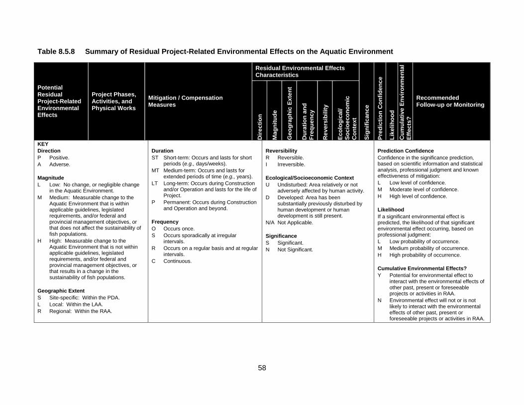
58
Table 8.5.8 Summary of Residual Project-Related Environmental Effects on the Aquatic Environment
Potential Residual Project-Related Environmental Effects
Project Phases, Activities, and Physical Works
Mitigation / Compensation Measures
Residual Environmental Effects Characteristics
Sign
ifica
nce
Pred
ictio
n C
onfid
ence
Like
lihoo
d C
umul
ativ
e En
viro
nmen
tal
Effe
cts?
Recommended Follow-up or Monitoring
Dire
ctio
n
Mag
nitu
de
Geo
grap
hic
Exte
nt
Dur
atio
n an
d Fr
eque
ncy
Rev
ersi
bilit
y
Ecol
ogic
al/
Soci
oeco
nom
ic
Con
text
KEY Direction P Positive. A Adverse. Magnitude L Low: No change, or negligible change
in the Aquatic Environment. M Medium: Measurable change to the
Aquatic Environment that is within applicable guidelines, legislated requirements, and/or federal and provincial management objectives, or that does not affect the sustainability of fish populations.
H High: Measurable change to the Aquatic Environment that is not within applicable guidelines, legislated requirements, and/or federal and provincial management objectives, or that results in a change in the sustainability of fish populations.
Geographic Extent S Site-specific: Within the PDA. L Local: Within the LAA. R Regional: Within the RAA.
Duration ST Short-term: Occurs and lasts for short
periods (e.g., days/weeks). MT Medium-term: Occurs and lasts for
extended periods of time (e.g., years). LT Long-term: Occurs during Construction
and/or Operation and lasts for the life of Project.
P Permanent: Occurs during Construction and Operation and beyond.
Frequency O Occurs once. S Occurs sporadically at irregular
intervals. R Occurs on a regular basis and at regular
intervals. C Continuous.
Reversibility R Reversible. I Irreversible. Ecological/Socioeconomic Context U Undisturbed: Area relatively or not
adversely affected by human activity. D Developed: Area has been
substantially previously disturbed by human development or human development is still present.
N/A Not Applicable. Significance S Significant. N Not Significant.
Prediction Confidence Confidence in the significance prediction, based on scientific information and statistical analysis, professional judgment and known effectiveness of mitigation: L Low level of confidence. M Moderate level of confidence. H High level of confidence. Likelihood If a significant environmental effect is predicted, the likelihood of that significant environmental effect occurring, based on professional judgment: L Low probability of occurrence. M Medium probability of occurrence. H High probability of occurrence. Cumulative Environmental Effects? Y Potential for environmental effect to
interact with the environmental effects of other past, present or foreseeable projects or activities in RAA.
N Environmental effect will not or is not likely to interact with the environmental effects of other past, present or foreseeable projects or activities in RAA.

59
Table 8.5.12 Summary of Residual Cumulative Environmental Effects on the Aquatic Environment
Cumulative Environmental Effects
Case Other Projects, Activities and
Actions
Mitigation / Compensation
Measures
Residual Cumulative Environmental Effects
Characteristics
Sign
ifica
nce
Pred
ictio
n C
onfid
ence
Like
lihoo
d
Recommended Follow-up or Monitoring
Dire
ctio
n
Mag
nitu
de
Geo
grap
hic
Exte
nt
Dur
atio
n an
d Fr
eque
ncy
Rev
ersi
bilit
y Ec
olog
ical
/ So
cioe
cono
mic
C
onte
xt
Change in the Aquatic Environment
Cumulative Environmental Effects with Project
• Past or Present Forestry and Agricultural Land Use.
• Potential Future Forestry and Agricultural Land Use.
• As listed in Table 8.5.8.
A L R P/C
R D N H - • None recommended beyond those measures recommended in Table 8.5.8.
Project Contribution to Cumulative Environmental Effects
A L L LT/O
R D N H -
KEY Direction P Positive. A Adverse. Magnitude L Low: No change, or negligible Change
in the Aquatic Environment. M Medium: Measurable change to the
Aquatic Environment that is within applicable guidelines, legislated requirements, and/or federal and provincial management objectives, or that does not affect the sustainability of fish populations.
H High: Measurable change to the Aquatic Environment that is not within applicable guidelines, legislated requirements, and/or federal and provincial management objectives, or that results in a change in the sustainability of fish populations.
Geographic Extent S Site-specific: Within the PDA. L Local: Within the LAA. R Regional: Within the RAA. Duration ST Short-term: Occurs and lasts for short
periods (e.g., days/weeks). MT Medium-term: Occurs and lasts for
extended periods of time (e.g., years). LT Long-term: Occurs during Construction
and/or Operation and lasts for the life of Project.
P Permanent: Occurs during Construction and Operation and beyond.
Frequency O Occurs once. S Occurs sporadically at irregular intervals. R Occurs on a regular basis and at regular
intervals. C Continuous.
Reversibility R Reversible. I Irreversible. Ecological/Socioeconomic Context U Undisturbed: Area relatively or
not adversely affected by human activity.
D Developed: Area has been substantially previously disturbed by human development or human development is still present.
N/A Not Applicable. Significance S Significant. N Not Significant.
Prediction Confidence Confidence in the significance prediction, based on scientific information and statistical analysis, professional judgment and known effectiveness of mitigation: L Low level of confidence. M Moderate level of confidence. H High level of confidence. Likelihood If a significant environmental effect is predicted, the likelihood of that significant environmental effect occurring (if applicable), based on professional judgment: L Low probability of occurrence. M Medium probability of occurrence. H High probability of occurrence. Other Projects, Activities, and Actions List of specific projects and activities that would contribute to the cumulative environmental effects.
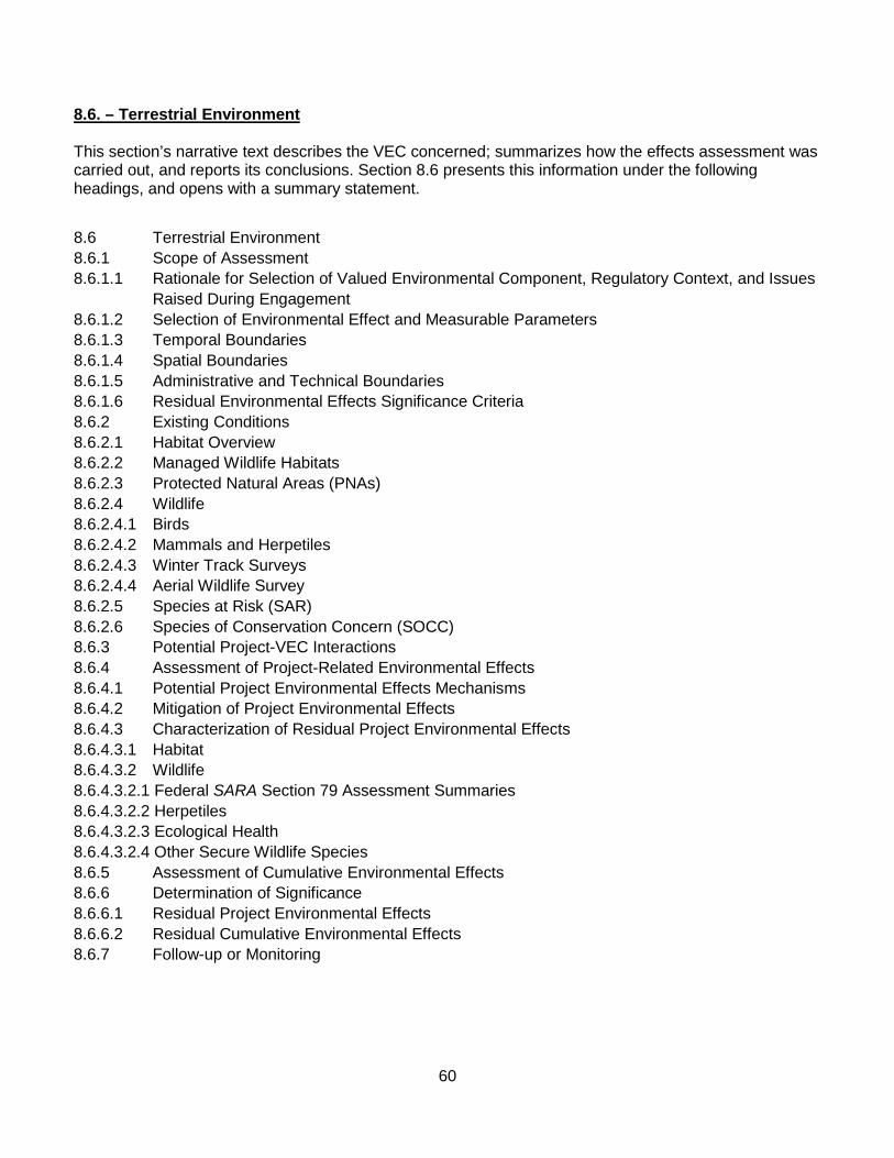
60
8.6. – Terrestrial Environment This section’s narrative text describes the VEC concerned; summarizes how the effects assessment was carried out, and reports its conclusions. Section 8.6 presents this information under the following headings, and opens with a summary statement.
8.6 Terrestrial Environment 8.6.1 Scope of Assessment 8.6.1.1 Rationale for Selection of Valued Environmental Component, Regulatory Context, and Issues Raised During Engagement 8.6.1.2 Selection of Environmental Effect and Measurable Parameters 8.6.1.3 Temporal Boundaries 8.6.1.4 Spatial Boundaries 8.6.1.5 Administrative and Technical Boundaries 8.6.1.6 Residual Environmental Effects Significance Criteria 8.6.2 Existing Conditions 8.6.2.1 Habitat Overview 8.6.2.2 Managed Wildlife Habitats 8.6.2.3 Protected Natural Areas (PNAs) 8.6.2.4 Wildlife 8.6.2.4.1 Birds 8.6.2.4.2 Mammals and Herpetiles 8.6.2.4.3 Winter Track Surveys 8.6.2.4.4 Aerial Wildlife Survey 8.6.2.5 Species at Risk (SAR) 8.6.2.6 Species of Conservation Concern (SOCC) 8.6.3 Potential Project-VEC Interactions 8.6.4 Assessment of Project-Related Environmental Effects 8.6.4.1 Potential Project Environmental Effects Mechanisms 8.6.4.2 Mitigation of Project Environmental Effects 8.6.4.3 Characterization of Residual Project Environmental Effects 8.6.4.3.1 Habitat 8.6.4.3.2 Wildlife 8.6.4.3.2.1 Federal SARA Section 79 Assessment Summaries 8.6.4.3.2.2 Herpetiles 8.6.4.3.2.3 Ecological Health 8.6.4.3.2.4 Other Secure Wildlife Species 8.6.5 Assessment of Cumulative Environmental Effects 8.6.6 Determination of Significance 8.6.6.1 Residual Project Environmental Effects 8.6.6.2 Residual Cumulative Environmental Effects 8.6.7 Follow-up or Monitoring

61
Summary Statement - Terrestrial Environment
The opening summary statement for Section 8.6 begins on Page 8-249. It explains that the Terrestrial Environment includes wildlife (fauna) and the habitats that support wildlife species. Specifically, this VEC focuses on birds, mammals, and herpetofauna, including species at risk (SAR) and species of conservation concern (SOCC), and their habitats. It notes that the Terrestrial Environment was selected as a VEC because of the intrinsic value of wildlife and wildlife habitat.
The Report states that the Project has the potential to interact with the Terrestrial Environment by changing terrestrial habitats and/or populations of wildlife that are important in a socioeconomic or environmental context, including SAR or SOCC. SOCC are species that, unlike SAR, are not listed under federal or New Brunswick legislation. SOCC are placed on lists as a precautionary measure that reflects an observed trend in their population status. SAR and SOCC are important indicators of ecosystem health and regional biodiversity.
The Report states that habitat would be lost as a result of the Construction and subsequent Operation of the Project. But some habitat restoration would occur upon Decommissioning, Reclamation and Closure, as Project elements are removed and some re-vegetation of disturbed areas is carried out.
The Report notes that wildlife habitat types within the LAA are common and found throughout Central New Brunswick, and no habitat would be lost that is unique to the region, or that is critical for the survival of a wildlife SAR or SOCC population.
It states that managed conservation areas including interior forest, deer wintering areas, old forest wildlife habitat, protected natural areas (existing and proposed) would not be affected substantially by the Construction and subsequent Operation of the Project.
The Report points out that the assessment of environmental effects identified the presence or possible presence of various secure species of birds, mammals and herpetiles in the PDA. It states that these secure species are not limited by their habitat and would not be adversely affected significantly by Project presence. SAR (e.g., Canada lynx, Bald Eagle, Common Nighthawk, Olive-sided Flycatcher, Canada Warbler, and Rusty Blackbird) and several SOCC have been recorded in or near the PDA, but they are not likely to be affected substantially by the Project activities.
The Project would not cause the decline of any population of a non-secure wildlife species such that their survival in New Brunswick is jeopardized. Adverse environmental effects of the Project on wildlife would be minimized or avoided through a number of mitigation measures including timing restrictions on clearing, and Project design.
The summary statement for Section 8.6 concludes by stating that, with the proposed mitigation and environmental protection measures, the residual environmental effects of the Project on the Terrestrial Environment during all phases of the Project would be not significant. While other projects or activities are ongoing within the proximal ecoregions and the Province as a whole, the potential cumulative environmental effects of the Project in combination with other projects or activities that have been or will be carried were rated not significant.
A total of 7 tables and 15 illustrative figures are included in Section 8.6 and listed below:

62
Tables Table 8.6.1 Measurable Parameters for the Terrestrial Environment Table 8.6.2 Bird Species Observed During Breeding Bird Surveys in 2001 and/or 2012 Table 8.6.3 Mammal and Herpetile Species Observed in the LAA During 2008, 2001, and 2012 Field Studies Table 8.6.4 Wildlife Species At Risk (SAR) with Records Within or Near the LAA Table 8.6.5 Potential Project Environmental Effects to the Terrestrial Environment Table 8.6.6 Summary of Residual Project-Related Environmental Effects on the Terrestrial Environment Table 8.6.7 Potential Cumulative Environmental Effects to the Terrestrial Environment Figures
Figure 8.6.1 Project Development Area (PDA), and Local Assessment Area (LAA) for the Terrestrial Environment – Mine Site Portion Figure 8.6.2 Project Development Area (PDA), and Local Assessment Area (LAA) for the Terrestrial Environment – Transmission Line Portion Figure 8.6.3 Regional assessment Area (RAA) for the Terrestrial Environment Figure 8.6.4 Habitats – Mine Site Portion Figure 8.6.5 Habitats – Transmission Line Portion Figure 8.6.6 Conservation Forest – Mine Site Portion Figure 8.6.7 Conservation Forest – Transmission Line Portion Figure 8.6.8 Interior Forest – Mine Site Portion Figure 8.6.9 Interior Forest – Transmission Line Portion Figure 8.6.10 Bird Survey Locations – Mine Site Portion Figure 8.6.11 Bird Survey Locations – Transmission Line Portion Figure 8.6.12 Locations of Recorded Species At Risk – Mine Site Portion Figure 8.6.13 Locations of Recorded Species At Risk – Transmission Line Portion Figure 8.6.14 Locations of Recorded Species of Conservation Concern – Mine Site Portion Figure 8.6.15 Locations of Recorded Species of Conservation Concern – Transmission Line Portion
Table 8.6.6 is reproduced below and summarizes the Residual Project-Related Environmental Effects on the Terrestrial Environment; mitigation or compensation measures proposed by the Study Team; characteristics of the residual effects, and recommended follow-up or monitoring.
Table 8.6.7 is reproduced below as well. It details and ranks Potential Cumulative Environmental Effects on the Terrestrial Environment.

63
Table 8.6.6 Summary of Residual Project-Related Environmental Effects on the Terrestrial Environment
Potential Residual Project-Related Environmental Effects
Project Phases, Activities, and
Physical Works Mitigation /
Compensation Measures
Residual Environmental Effects Characteristics
Sign
ifica
nce
Pred
ictio
n C
onfid
ence
Like
lihoo
d C
umul
ativ
e En
viro
nmen
tal
Effe
cts?
Recommended Follow-up or Monitoring
Dire
ctio
n
Mag
nitu
de
Geo
grap
hic
Exte
nt
Dur
atio
n an
d Fr
eque
ncy
Rev
ersi
bilit
y
Ecol
ogic
al/
Soci
oeco
nom
ic
Con
text
Change in Wildlife Populations
Construction • Site Preparation
of Open Pit, TSF, and Buildings and Ancillary Facilities.
• Physical Construction and Installation of Project Facilities.
• Physical Construction of Transmission Lines and Associated Infrastructure.
• Physical Construction of Realigned Fire Road, New Site Access Road, and Internal Site Roads
Mitigation to be considered in Construction and Operation is as follows. • SML will work with NBDNR and
Crown licensees and sub-licensees to communicate information about the Project footprint and schedule for habitat alteration so that it can be factored into broader forest management and other related wildlife management initiatives in the region.
• Avoidance of, to the extent feasible, known locations of wildlife SAR and SOCC.
• Minimization of the loss or fragmentation of mature forest habitat and interior forest.
• Co-location of linear facilities, where possible, to other linear disturbances to minimize the environmental effects of fragmentation.
• Minimization of linear corridor width/footprint and clearing to extent practicable.
• Minimization of size of temporary work spaces.
• Limiting clearing and grubbing to infrastructure footprint to that
A L S ST/O
I D N H - Y • Point count surveys in preferred habitats of Canada Warbler, Olive-sided Flycatcher, and Rusty Blackbirds, including pre-Construction and post-Construction/ clearing surveys where, in consultation with the Canadian Wildlife Service and NBDNR, it is determined that habitat is a limiting factor for these bird SAR.
• Common Nighthawk Surveys conducted in 2011 and 2012 could be repeated at the same locations prior to Construction and post-Construction, if determined to be necessary in consultation with the Canadian Wildlife Service and NBDNR.
• Point count surveys along the transmission line could be conducted where Bird SAR were

64
Table 8.6.6 Summary of Residual Project-Related Environmental Effects on the Terrestrial Environment
Potential Residual Project-Related Environmental Effects
Project Phases, Activities, and
Physical Works Mitigation /
Compensation Measures
Residual Environmental Effects Characteristics
Sign
ifica
nce
Pred
ictio
n C
onfid
ence
Like
lihoo
d C
umul
ativ
e En
viro
nmen
tal
Effe
cts?
Recommended Follow-up or Monitoring
Dire
ctio
n
Mag
nitu
de
Geo
grap
hic
Exte
nt
Dur
atio
n an
d Fr
eque
ncy
Rev
ersi
bilit
y
Ecol
ogic
al/
Soci
oeco
nom
ic
Con
text
which is necessary. • Maintenance of natural buffers
around wetlands and riparian zones.
• Use of down-lighting, a technique of directing night lighting downward so as not to attract migrating birds;
• An Avifauna Management Plan (AMP) to address incidental take.
• Establishment of buffers and protection of active migratory bird nests until fledging, upon their discovery in work areas.
• Scheduling of clearing activities outside the breeding season of migratory birds (when possible).
• Environmentally sensitive areas identified during clearing and construction will be flagged and avoided until an assessment has been completed.
• Development of a wildlife awareness program for Construction and Operation.
• Permitting the development of shrub vegetation along transmission lines (to the extent practical) to promote their use by wildlife.
recorded in 2012, prior to Construction, during Construction, and following Construction, if determined to be required in consultation with the Canadian Wildlife Service and NBDNR.
• Monitor bird collisions along the transmission line where warranted in consultation with NBDNR and the Canadian Wildlife Service.

65
Table 8.6.6 Summary of Residual Project-Related Environmental Effects on the Terrestrial Environment
Potential Residual Project-Related Environmental Effects
Project Phases, Activities, and
Physical Works Mitigation /
Compensation Measures
Residual Environmental Effects Characteristics
Sign
ifica
nce
Pred
ictio
n C
onfid
ence
Like
lihoo
d C
umul
ativ
e En
viro
nmen
tal
Effe
cts?
Recommended Follow-up or Monitoring
Dire
ctio
n
Mag
nitu
de
Geo
grap
hic
Exte
nt
Dur
atio
n an
d Fr
eque
ncy
Rev
ersi
bilit
y
Ecol
ogic
al/
Soci
oeco
nom
ic
Con
text
• Rehabilitate access routes that are no longer needed.
• Proper storage of food and waste on site so as to avoid the attraction of wildlife to the Project.
• Use of approved noise arrest mufflers on all equipment to reduce potential environmental effects of noise.
• Implementation of various dust control measures.
• Vehicle operation at appropriate speed and yielding to wildlife.
Operation • Mine Waste and
Water Management.
• See all measures identified above.
A L S P/R I D N H - Y Continue collision monitoring where warranted along transmission line.
Decommissioning, Reclamation and Closure
Same as during Construction and Operation phases above.
Residual Environmental Effects for all Phases
N H - Y

66
Table 8.6.6 Summary of Residual Project-Related Environmental Effects on the Terrestrial Environment
Potential Residual Project-Related Environmental Effects
Project Phases, Activities, and
Physical Works Mitigation /
Compensation Measures
Residual Environmental Effects Characteristics
Sign
ifica
nce
Pred
ictio
n C
onfid
ence
Like
lihoo
d C
umul
ativ
e En
viro
nmen
tal
Effe
cts?
Recommended Follow-up or Monitoring
Dire
ctio
n
Mag
nitu
de
Geo
grap
hic
Exte
nt
Dur
atio
n an
d Fr
eque
ncy
Rev
ersi
bilit
y
Ecol
ogic
al/
Soci
oeco
nom
ic
Con
text
KEY Direction: P Positive. A Adverse. Magnitude: L Low - the residual Project environmental
effects (alteration/loss) are not expected to exceed 5 percent of the known population in the Province or RAA for secure and non-sure populations, respectively, and/or are not measurable.
M Moderate - the residual Project environmental effects (alteration/loss) are expected to be greater than 5 percent and not exceed 25 percent of the known population in the Province or RAA for secure and non-secure populations, respectively, and the effect can be measured.
H High - the residual Project environmental effects to (alteration/loss) are expected to exceed 25 percent of the known population in the Province or RAA for secure and non-secure populations, respectively; the effect can be easily observed, measured and described, and may be widespread.
Geographic Extent: S Site-specific: Within the PDA. L Local: Within the LAA. R Regional: Within the RAA.
Duration: ST Short-term: Occurs and lasts for short
periods (e.g., days/weeks). MT Medium-term: Occurs and lasts for
extended periods of time (e.g., years). LT Long-term: Occurs during Construction
and/or Operation and lasts for the life of Project.
P Permanent: Occurs during Construction and Operation and beyond.
Frequency: O Occurs once. S Occurs sporadically at irregular intervals. R Occurs on a regular basis and at regular
intervals. C Continuous.
Reversibility: R Reversible. I Irreversible. Ecological/Socioeconomic Context: U Undisturbed: Area relatively or not
adversely affected by human activity.
D Developed: Area has been substantially previously disturbed by human development or human development is still present.
N/A Not Applicable. Significance: S Significant. N Not Significant.
Prediction Confidence: Confidence in the significance prediction, based on scientific information and statistical analysis, professional judgment and known effectiveness of mitigation: L Low level of confidence. M Moderate level of confidence. H High level of confidence. Likelihood: If a significant environmental effect is predicted, the likelihood of that significant environmental effect occurring, based on professional judgment: L Low probability of occurrence. M Medium probability of occurrence. H High probability of occurrence. Cumulative Environmental Effects? Y Potential for environmental effect to
interact with the environmental effects of other past, present or foreseeable projects or activities in RAA.
N Environmental effect will not or is not likely to interact with the environmental effects of other past, present or foreseeable projects or activities in RAA.
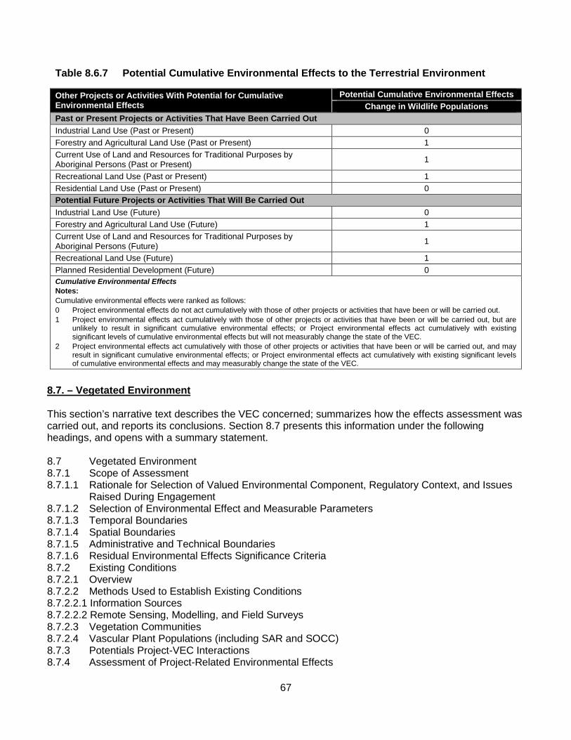
67
Table 8.6.7 Potential Cumulative Environmental Effects to the Terrestrial Environment
Other Projects or Activities With Potential for Cumulative Environmental Effects
Potential Cumulative Environmental Effects Change in Wildlife Populations
Past or Present Projects or Activities That Have Been Carried Out Industrial Land Use (Past or Present) 0 Forestry and Agricultural Land Use (Past or Present) 1 Current Use of Land and Resources for Traditional Purposes by Aboriginal Persons (Past or Present) 1
Recreational Land Use (Past or Present) 1 Residential Land Use (Past or Present) 0 Potential Future Projects or Activities That Will Be Carried Out Industrial Land Use (Future) 0 Forestry and Agricultural Land Use (Future) 1 Current Use of Land and Resources for Traditional Purposes by Aboriginal Persons (Future) 1
Recreational Land Use (Future) 1 Planned Residential Development (Future) 0 Cumulative Environmental Effects Notes: Cumulative environmental effects were ranked as follows: 0 Project environmental effects do not act cumulatively with those of other projects or activities that have been or will be carried out. 1 Project environmental effects act cumulatively with those of other projects or activities that have been or will be carried out, but are
unlikely to result in significant cumulative environmental effects; or Project environmental effects act cumulatively with existing significant levels of cumulative environmental effects but will not measurably change the state of the VEC.
2 Project environmental effects act cumulatively with those of other projects or activities that have been or will be carried out, and may result in significant cumulative environmental effects; or Project environmental effects act cumulatively with existing significant levels of cumulative environmental effects and may measurably change the state of the VEC.
8.7. – Vegetated Environment This section’s narrative text describes the VEC concerned; summarizes how the effects assessment was carried out, and reports its conclusions. Section 8.7 presents this information under the following headings, and opens with a summary statement. 8.7 Vegetated Environment 8.7.1 Scope of Assessment 8.7.1.1 Rationale for Selection of Valued Environmental Component, Regulatory Context, and Issues
Raised During Engagement 8.7.1.2 Selection of Environmental Effect and Measurable Parameters 8.7.1.3 Temporal Boundaries 8.7.1.4 Spatial Boundaries 8.7.1.5 Administrative and Technical Boundaries 8.7.1.6 Residual Environmental Effects Significance Criteria 8.7.2 Existing Conditions 8.7.2.1 Overview 8.7.2.2 Methods Used to Establish Existing Conditions 8.7.2.2.1 Information Sources 8.7.2.2.2 Remote Sensing, Modelling, and Field Surveys 8.7.2.3 Vegetation Communities 8.7.2.4 Vascular Plant Populations (including SAR and SOCC) 8.7.3 Potentials Project-VEC Interactions 8.7.4 Assessment of Project-Related Environmental Effects

68
8.7.4.1 Potential Project Environmental Effects Mechanisms 8.7.4.2 Mitigation of Project Environmental Effects 8.7.4.3 Characterization of Residual Project Environmental Effects 8.7.5 Assessment of Cumulative Environmental Effects 8.7.5.1 Cumulative Environmental Effects Mechanisms 8.7.5.2 Mitigation of Cumulative Environmental Effects 8.7.5.3 Characterization of Residual Cumulative Environmental Effects 8.7.6 Determination of Significance 8.7.6.1 Residual Project Environmental Effects 8.7.6.2 Residual Cumulative Environmental Effects 8.7.7 Follow-up or Monitoring Summary Statement – Vegetated Environment The opening summary statement for Section 8.7 begins on Page 8-335. It defines the Vegetated Environment as the physical area where vegetation is found, and includes all vascular plants and vegetation communities, as well as the soil, climatic, and hydrological conditions that support them in upland, wetland, and aquatic habitats.
The Report notes that the Vegetated Environment was selected as a VEC because of the potential for the Project to affect the Vegetated Environment, and because of the intrinsic value of plants and vegetation communities for biodiversity. It points out that this VEC focused on “rare” plants and vegetation communities as defined below, within the zone of influence of the Project, as the most important indicators of biodiversity.
A variety of information sources, including field surveys, were used to describe the existing conditions within the PDA and LAA, focusing on vegetation communities (including wetlands), and vascular plant species at risk (SAR) and species of conservation concern (SOCC).
Potential Project-VEC interactions were evaluated, including Construction-related activities such as site preparation for all mine-related infrastructure such as the tailings storage facility (TSF); ore processing facilities and open pit; the new 138 kV transmission line construction; relocation of the existing 345 kV transmission line; construction of the site access road, internal site roads, and relocation of the Fire Road. These were determined to be the Project-related activities that had the highest potential for causing adverse environmental effects to biodiversity and the Vegetated Environment.
The Report states that mitigation measures have been outlined and potential cumulative environmental effects between the Project and other projects or activities that have been or will be carried out were also evaluated. A particular focus was placed on future forestry and agricultural land use, the activities determined to be most likely to potentially interact cumulatively with the Project on the Vegetated Environment.
It reports that field surveys conducted in the LAA identified 446 vascular plant species. No vascular plant SAR were discovered during field surveys, and only one plant SOCC (Nodding ladies’-tresses, ‘Spiranthes cernua’) was found within the LAA, in the corridor for the planned relocation of the existing 345 kV transmission line.

69
This SOCC was found immediately adjacent to an existing forest resource road, and as mitigation, clearing would be restricted in this area. With avoidance of clearing and placement of transmission line poles to span this area, the identified SOCC would not be directly affected by the Project.
The Report states that the Project would result in the loss and/or change in some vegetation communities, as Project facilities are constructed. But, with mitigation, the resulting residual loss represents less than 1.6% of the vegetation communities in the Regional Assessment Area (RAA), and thus the resulting environmental effects were rated not significant.
Cumulative environmental effects resulting from the Project and future forestry and agricultural use could result in a temporary change in the planned removal or change in vegetation communities within the RAA. This would be related to forest harvesting and the removal of timber (resulting from some stands within the PDA being removed earlier than planned and the subsequent need to adjust harvest plans for the area), as well as a temporary displacement of Old Forest Communities designated by the NBDNR.
The Report states that these communities can be replaced with planning, where appropriate stands are identified for management as Old Forest Communities. It adds that any losses would be minor (i.e., represent less than 0.8% of the affected Old Forest Communities in the RAA) and temporary in nature and are thus rated not significant. Monitoring of the SOCC population, particularly for Nodding ladies’-tresses, would be proposed for years 1, 3, and 5 following the completion of Construction.
A total of 9 tables and 3 illustrative figures are included in Section 8.7 and listed below: Tables Table 8.7.1 Measurable Parameters for Vegetated Environment Table 8.7.2 Distribution of Vegetation Communities Within the LAA Table 8.7.3 Vascular Plant Species Observed in the LAA Surrounding Areas Table 8.7.4 Potential Project Environmental Effects to the Vegetated Environment Table 8.7.5 Summary of Residual Project-Related Environmental Effects on the Vegetated Environment Table 8.7.6 Ecosites kWithin the LAA and RAA, and % of RAA That May Be Lost or Altered as a Result of the Project Table 8.7.7 NBDNR Old Forest Communities within PDA, LAA (but outside PDA), and Ecoregion Table 8.7.8 Potential Cumulative Environmental Effects to the Vegetated Environment Table 8.7.9 Summary of Residual Cumulative Environmental Effects on the Vegetated Environment Figures Figure 8.7.1 Project Development Area (PDA), and Local Assessment Area (LAA) for the Vegetated Environment Figure 8.7.2 Vegetation Communities within the PDA and LAA, and Species of Conservation Concern
(North) Figure 8.7.3 Vegetation Communities within the PDA and LAA, and Species of Conservation Concern
(South) Table 8.7.5 is reproduced below and summarizes the Residual Project-Related Environmental Effects on the Vegetated Environment; mitigation or compensation measures proposed by the Study Team;

70
characteristics of the residual effects, and recommended follow-up or monitoring. Table 8.7.9 is reproduced below as well. It details and ranks Potential Cumulative Environmental Effects on the Vegetated Environment.

71
Table 8.7.5 Summary of Residual Project-Related Environmental Effects on the Vegetated Environment
Potential Residual Project-Related Environmental Effects
Project Phases, Activities, and
Physical Works Mitigation / Compensation Measures
Residual Environmental Effects Characteristics
Sign
ifica
nce
Pred
ictio
n C
onfid
ence
Like
lihoo
d C
umul
ativ
e En
viro
nmen
tal
Effe
cts?
Recommended Follow-up or Monitoring
Dire
ctio
n
Mag
nitu
de
Geo
grap
hic
Exte
nt
Dur
atio
n an
d Fr
eque
ncy
Rev
ersi
bilit
y
Ecol
ogic
al/
Soci
oeco
nom
ic
Con
text
Change in the Vegetated Environment
Construction: • Site Preparation of
Open Pit, TSF, Buildings and Ancillary Facilities.
• Physical Construction of Transmission Lines and Associated Infrastructure.
• Physical Construction of Realigned Fire Road, New Site Access Road, and Internal Site Roads.
Mitigation to be implemented in Construction is as follows. • Clearing activities will be restricted to
necessary portions of the PDA, and not beyond.
• Standard erosion and sedimentation control measures will be employed, including: ● erosion control fencing; ● check dams; ● sedimentation control ponds where
appropriate; ● construction sequencing to minimize
soil exposure; ● retaining existing vegetation as long
as possible; ● vegetation and mulching of denuded
areas; ● diverting runoff away from denuded
areas; ● optimizing length and steepness of
slope; ● keeping surface water runoff
velocities low; ● proper sizing and protecting of
drainage ways and outlets; ● intercepting of sediments on site;
and ● inspecting and maintaining the
above-mentioned control measures.
A L L LT/C R D N H -- Y Flag the population of nodding ladies’-tresses (Spiranthes cernua) for avoidance during Construction, and monitor at Years 1, 3, and 5 following the completion of Construction to confirm effectiveness of mitigation.

72
Table 8.7.5 Summary of Residual Project-Related Environmental Effects on the Vegetated Environment
Potential Residual Project-Related Environmental Effects
Project Phases, Activities, and
Physical Works Mitigation / Compensation Measures
Residual Environmental Effects Characteristics
Sign
ifica
nce
Pred
ictio
n C
onfid
ence
Like
lihoo
d C
umul
ativ
e En
viro
nmen
tal
Effe
cts?
Recommended Follow-up or Monitoring
Dire
ctio
n
Mag
nitu
de
Geo
grap
hic
Exte
nt
Dur
atio
n an
d Fr
eque
ncy
Rev
ersi
bilit
y
Ecol
ogic
al/
Soci
oeco
nom
ic
Con
text
• Clean, coarse fill material will be used for grading, to minimize the risk of introducing or spreading exotic and/or invasive vascular plant species.
• Construction machinery will be cleaned prior to entering and leaving wetlands to minimize the risk of introducing or spreading exotic and/or invasive species from one wetland to another.
• Any vascular plant SAR or SOCC within or adjacent to the PDA will be flagged and/or fenced off, and construction activities will be minimized in areas adjacent to SAR or SOCC, whenever possible.
• NB Power will follow an EPP during the construction of the transmission line and associated infrastructure, which includes mitigation measures for vascular plant SAR or SOCC within the transmission line ROW.
• Construction activities will be minimized in wetland areas to reduce the potential environmental effects of disturbance, such as erosion and sedimentation, and the introduction or spread of exotic and/or invasive vascular plant species.
• Forested Crown land that will be removed from the PDA will be accounted for by NBDNR in consideration of the results of this

73
Table 8.7.5 Summary of Residual Project-Related Environmental Effects on the Vegetated Environment
Potential Residual Project-Related Environmental Effects
Project Phases, Activities, and
Physical Works Mitigation / Compensation Measures
Residual Environmental Effects Characteristics
Sign
ifica
nce
Pred
ictio
n C
onfid
ence
Like
lihoo
d C
umul
ativ
e En
viro
nmen
tal
Effe
cts?
Recommended Follow-up or Monitoring
Dire
ctio
n
Mag
nitu
de
Geo
grap
hic
Exte
nt
Dur
atio
n an
d Fr
eque
ncy
Rev
ersi
bilit
y
Ecol
ogic
al/
Soci
oeco
nom
ic
Con
text
assessment and the appropriate forest licensee in the management plans of the subsequent forest cycle..
• Conservation Vegetation Communities within the PDA will be replaced within the ecoregion and license block whenever stands meeting the criteria are available. The licensees, the regional NBDNR office, and the NBDNR Fish and Wildlife Branch will collaborate to identify replacement stands.
Operation
Decommissioning, Reclamation and Closure
Residual Environmental Effects for all Phases
N H -- Y

74
Table 8.7.5 Summary of Residual Project-Related Environmental Effects on the Vegetated Environment
Potential Residual Project-Related Environmental Effects
Project Phases, Activities, and
Physical Works Mitigation / Compensation Measures
Residual Environmental Effects Characteristics
Sign
ifica
nce
Pred
ictio
n C
onfid
ence
Like
lihoo
d C
umul
ativ
e En
viro
nmen
tal
Effe
cts?
Recommended Follow-up or Monitoring
Dire
ctio
n
Mag
nitu
de
Geo
grap
hic
Exte
nt
Dur
atio
n an
d Fr
eque
ncy
Rev
ersi
bilit
y
Ecol
ogic
al/
Soci
oeco
nom
ic
Con
text
KEY Direction P Positive. A Adverse. Magnitude L Low: <5% of vegetation communities or SOCC
populations within the RAA will be exposed to the effect, or no measurable change in vegetation communities or population size relative to baseline conditions. SAR are not affected.
M Medium: 5% - 25% of vegetation communities or SOCC populations within the RAA will be exposed to the effect, or a measurable change in vegetation communities or population size relative to baseline conditions that does not cause management concern. SAR are not affected.
H High: >25% of vegetation communities or SOCC populations within the RAA will be exposed to the effect, or a measurable change in vegetation communities or population size relative to baseline conditions that does cause management concern. SAR may be affected.
Geographic Extent S Site-specific: Within the PDA. L Local: Within the LAA. R Regional: Within the RAA.
Duration ST Short-term: Occurs and lasts for
short periods (e.g., days/weeks). MT Medium-term: Occurs and lasts for
extended periods of time (e.g., years).
LT Long-term: Occurs during Construction and/or Operation and lasts for the life of Project.
P Permanent: Occurs during Construction and Operation and beyond.
Frequency O Occurs once. S Occurs sporadically at irregular
intervals. R Occurs on a regular basis and at
regular intervals. C Continuous.
Reversibility R Reversible. I Irreversible. Ecological/Socioeconomic Context U Undisturbed: Area relatively or
not adversely affected by human activity.
D Developed: Area has been substantially previously disturbed by human development or human development is still present.
N/A Not Applicable. Significance S Significant. N Not Significant.
Prediction Confidence Confidence in the significance prediction, based on scientific information and statistical analysis, professional judgment and known effectiveness of mitigation: L Low level of confidence. M Moderate level of confidence. H High level of confidence. Likelihood If a significant environmental effect is predicted, the likelihood of that significant environmental effect occurring is determined, based on professional judgment: L Low probability of occurrence. M Medium probability of occurrence. H High probability of occurrence. Cumulative Environmental Effects? Y Potential for environmental effect to
interact with the environmental effects of other past, present or foreseeable future projects or activities in RAA.
N Environmental effect will not or is not likely to interact with the environmental effects of other past, present or foreseeable future projects or activities in RAA.

75
Table 8.7.9 Summary of Residual Cumulative Environmental Effects on the Vegetated Environment
Cumulative Environmental Effects
Case Other Projects, Activities and
Actions Mitigation /
Compensation Measures
Residual Cumulative Environmental Effects
Characteristics
Sign
ifica
nce
Pred
ictio
n C
onfid
ence
Like
lihoo
d
Recommended Follow-up or Monitoring
Dire
ctio
n
Mag
nitu
de
Geo
grap
hic
Exte
nt
Dur
atio
n an
d Fr
eque
ncy
Rev
ersi
bilit
y Ec
olog
ical
/ So
cioe
cono
mic
C
onte
xt
Change in the Vegetated Environment
Cumulative Environmental Effects with Project
• Forestry and Agricultural Land Use (Future).
• Forested Crown land that will be removed from the PDA will be accounted for by NBDNR and the appropriate forest licensee in the management plans of the subsequent forest cycle.
• NBDNR Conservation Vegetation Communities within the PDA will be replaced within the ecoregion and license block whenever stands meeting the criteria are available. The licensee, the regional NBDNR office, and the NBDNR Fish and Wildlife Branch will collaborate to identify replacement stands.
A L R LT/O
R D N H -- None recommended.
Project Contribution to Cumulative Environmental Effects
A L S LT/O
R D N H --

76
Table 8.7.9 Summary of Residual Cumulative Environmental Effects on the Vegetated Environment
Cumulative Environmental Effects
Case Other Projects, Activities and
Actions Mitigation /
Compensation Measures
Residual Cumulative Environmental Effects
Characteristics
Sign
ifica
nce
Pred
ictio
n C
onfid
ence
Like
lihoo
d
Recommended Follow-up or Monitoring
Dire
ctio
n
Mag
nitu
de
Geo
grap
hic
Exte
nt
Dur
atio
n an
d Fr
eque
ncy
Rev
ersi
bilit
y Ec
olog
ical
/ So
cioe
cono
mic
C
onte
xt
KEY Direction P Positive. A Adverse. Magnitude L Low: <5% of vegetation communities or
SOCC populations within the RAA will be exposed to the effect, or no measurable change in vegetation communities or population size relative to baseline conditions. SAR are not affected.
M Medium: 5% - 25% of vegetation communities or SOCC populations within the RAA will be exposed to the effect, or a measurable change in vegetation communities or population size relative to baseline conditions that does not cause management concern. SAR are not affected.
H High: >25% of vegetation communities or SOCC populations within the RAA will be exposed to the effect, or a measurable change in vegetation communities or population size relative to baseline conditions that does cause management concern. SAR may be affected.
Geographic Extent S Site-specific: Within the PDA. L Local: Within the LAA. R Regional: Within the RAA.
Duration ST Short-term: Occurs and lasts for
short periods (e.g., days/weeks). MT Medium-term: Occurs and lasts
for extended periods of time (e.g., years).
LT Long-term: Occurs during Construction and/or Operation and lasts for the life of Project.
P Permanent: Occurs during Construction and Operation and beyond.
Frequency O Occurs once. S Occurs sporadically at irregular
intervals. R Occurs on a regular basis and at
regular intervals. C Continuous.
Reversibility R Reversible. I Irreversible. Ecological/Socioeconomic Context U Undisturbed: Area relatively or not
adversely affected by human activity. D Developed: Area has been
substantially previously disturbed by human development or human development is still present.
N/A Not Applicable. Significance S Significant. N Not Significant.
Prediction Confidence Confidence in the significance prediction, based on scientific information and statistical analysis, professional judgment and known effectiveness of mitigation: L Low level of confidence. M Moderate level of confidence. H High level of confidence. Likelihood If a significant environmental effect is predicted, the likelihood of that significant environmental effect occurring is determined, based on professional judgment: L Low probability of occurrence. M Medium probability of occurrence. H High probability of occurrence. Other Projects, Activities, and Actions List of specific projects or activities that would contribute to the cumulative environmental effects.
77
8.8. – Wetland Environment This section’s narrative text describes the VEC concerned; summarizes how the effects assessment was carried out, and reports its conclusions. Section 8.8 presents this information under the following headings, and opens with a summary statement. 8.8 Wetland Environment 8.8.1 Scope of Assessment 8.8.1.1 Rationale for Selection of Valued Environmental Component, Regulatory Context, and Issues
Raised During Engagement 8.8.1.2 Selection of Environmental Effect and Measurable Parameters 8.8.1.3 Temporal Boundaries 8.8.1.4 Spatial Boundaries 8.8.1.5 Administrative and Technical Boundaries 8.8.1.6 Residual Environmental Effects Significance Criteria 8.8.2 Existing Conditions 8.8.2.1 Overview 8.8.2.2 Wetland Evaluation Methods 8.8.2.2.1 Information Sources 8.8.2.2.2 Remote Sensing, Modeling, and Field Surveys 8.8.2.3 Wetlands in the LAA 8.8.2.3.1 Wetland Function 8.8.3 Potential Project-VEC Interactions 8.8.4 Assessment of Project-Related Environmental Effects 8.8.4.1 Potential Project Environmental Effects Mechanisms 8.8.4.2 Mitigation of Project Environmental Effects 8.8.4.2.1 Wetland Mitigation in New Brunswick 8.8.4.3 Characterization of Residual Project Environmental Effects 8.8.4.3.1 Direct Loss of GeoNB-mapped Wetlands 8.8.4.3.2 Direct Loss of Unmapped Wetlands 8.8.4.3.3 Percent Loss within the RAA 8.8.4.3.4 Indirect Loss of Wetlands During Operation 8.8.4.3.5 Provincially Significant Wetlands 8.8.5 Assessment of Cumulative Environmental Effects 8.8.5.1 Cumulative Environmental Effects Mechanisms 8.8.5.2 Mitigation of Cumulative Environmental Effects 8.8.5.3 Characterization of Residual Cumulative Environmental Effects 8.8.6 Determination of Significance 8.8.6.1 Residual Project Environmental Effects 8.8.6.2 Residual Cumulative Environmental Effects 8.8.7 Follow-up or Monitoring Summary Statement - Wetland Environment
The opening summary statement for Section 8.8 begins on Page 8-387. It defines the Wetland Environment as the sum of water, soil, and biota that occur in areas that are saturated with water for sufficient periods to promote aquatic processes, as indicated by hydric soils, hydrophytic vegetation, and biological activities adapted to the wet environment.

78
It notes that the Wetland Environment was selected as a VEC because of the potential for interactions between the Project and the Wetland Environment. in consideration of the value of wetlands on a local and landscape scale as recognized by regulatory agencies, the public, and other stakeholders, and in recognition of both federal and provincial wetland conservation policy objectives of no net loss of wetland function.
The Report points out that various information sources were used to create a wetland model for the LAA, which was subsequently verified and corrected through extensive field surveys, during which descriptions of wetlands and observations on wetland function were noted. Potential Project-VEC interactions were evaluated, including Construction activities such as site preparation, which would lead to the direct loss of GeoNB-mapped wetlands and unmapped wetlands within the PDA, and Operation activities which might lead to the indirect loss of wetland in the LAA (outside of the PDA) due to changes in drainage and local hydrology.
Mitigation measures were outlined, including compensation for wetland loss and/or functional changes. Potential cumulative environmental effects of the Project in combination with other projects or activities that have been or will be carried out were also evaluated, including particularly future forestry and agricultural land use, which was determined to be most likely to potentially interact cumulatively with the Project on the Wetland Environment in the future.
In concluding the summary statement for Section 8.8., the Report states that, although the Project would result in the direct and indirect loss of area and/or function of some wetlands, the direct loss of both GeoNB-mapped as well as unmapped wetlands in the PDA would be compensated in accordance with the applicable provincial and federal wetland conservation policies. It explains that, for unmapped wetlands, this residual loss represents less than 0.1% of all wetland in the RAA. The extent of indirect loss of GeoNB-mapped and unmapped wetland in areas outside of the PDA would be evaluated through a follow-up program, the results of which would be used to determine the requirements for adaptive management.
The Report states that, overall, it is not expected that these losses would be substantive. Consequently the environmental effects of the Project on the Wetland Environment were rated not significant.
A total of 8 tables and 7 illustrative figures are included in Section 8.8 and listed below: Tables Table 8.8.1 Measurable Parameters for Wetland Environment Table 8.8.2 Wetland Area, Vegetation and Hydrologic Characteristics for the PDA and LAA (Including the New 138 kV Transmission Line) Table 8.8.3 Summary of Wetland Functions for Each Wetland Type by Function Category Table 8.8.4 Potential Project Environmental Effects to the Wetland Environment Table 8.8.5 Summary of Residual Project-Related Environmental Effects on the Wetland Environment Table 8.8.6 Wetlands Within the PDA, LAA and RAA (Crown Land Only and Estimated Total RAA), and Percent of RAA that May Be Directly or Indirectly Lost as a Result of the Project (Excluding 138 kV Transmission Line Corridor)

79
Table 8.8.7 Potential Cumulative Environmental Effects to the Wetland Environment Table 8.8.8 Summary of Residual Cumulative Environmental Effects on the Wetland Environment
Figures
Figure 8.8.1 Project Development Area (PDA), and Local Assessment Area (LAA) for the Wetland Environment Figure 8.8.2 Regional Assessment Area (RAA) for the Wetland Environment Figure 8.8.3 Wetland Types (North) Figure 8.8.4 Wetland Types (South) Figure 8.8.5 Landscape Position of Wetlands – Sisson Brook Figure 8.8.6 Landscape Position of Wetlands – Bird Brook Figure 8.8.7 Potential Environmental Effects on Wetlands
Table 8.8.5 is reproduced below and summarizes the Residual Project-Related Environmental Effects on the Wetland Environment; mitigation or compensation measures proposed by the Study Team; characteristics of the residual effects, and recommended follow-up or monitoring. Table 8.8.8 is reproduced below as well. It details and ranks Potential Cumulative Environmental Effects on the Wetland Environment.

80
Table 8.8.5 Summary of Residual Project-Related Environmental Effects on the Wetland Environment
Potential Residual Project-Related Environmental Effects
Project Phases, Activities, and
Physical Works Mitigation / Compensation Measures
Residual Environmental Effects Characteristics
Sign
ifica
nce
Pred
ictio
n C
onfid
ence
Like
lihoo
d
Cum
ulat
ive
Envi
ronm
enta
l Ef
fect
s?
Recommended Follow-up or Monitoring
Dire
ctio
n
Mag
nitu
de
Geo
grap
hic
Exte
nt
Dur
atio
n an
d Fr
eque
ncy
Rev
ersi
bilit
y
Ecol
ogic
al/
Soci
oeco
nom
ic
Con
text
Change in Wetland Environment • Change in
wetland area (ha);
• Change in wetland function.
Construction: • Site Preparation
of Open Pit, TSF, and Buildings and Ancillary Facilities.
• Physical Construction and Installation of Project Facilities.
• Physical Construction of Realigned Fire Road, New Site Access Road, and Internal Site Roads.
Mitigation to be implemented during Construction is as follows. • Clearing activities will be restricted to
necessary portions of the PDA, and not beyond, to minimize the amount of habitat lost or altered through direct disturbance, or adjacent edge effects.
• Standard erosion and sedimentation control measures will be employed, including: ● erosion control fencing; ● check dams; ● sedimentation control ponds
where appropriate; ● construction sequencing to
minimize soil exposure; ● retaining existing vegetation as
long as possible; ● re-vegetation and mulching of
denuded areas; ● diverting run-off away from
denuded areas; ● optimizing length and steepness
of slope; ● keeping surface water run-off
velocities low; ● proper sizing and protecting of
drainage ways and outlets; ● intercepting of sediments on site;
and
A L S LT/OC
R D N H -- Y None recommended.

81
Table 8.8.5 Summary of Residual Project-Related Environmental Effects on the Wetland Environment
Potential Residual Project-Related Environmental Effects
Project Phases, Activities, and
Physical Works Mitigation / Compensation Measures
Residual Environmental Effects Characteristics
Sign
ifica
nce
Pred
ictio
n C
onfid
ence
Like
lihoo
d
Cum
ulat
ive
Envi
ronm
enta
l Ef
fect
s?
Recommended Follow-up or Monitoring
Dire
ctio
n
Mag
nitu
de
Geo
grap
hic
Exte
nt
Dur
atio
n an
d Fr
eque
ncy
Rev
ersi
bilit
y
Ecol
ogic
al/
Soci
oeco
nom
ic
Con
text
● inspecting and maintaining the above-mentioned control measures.
• Development of a Wetland Compensation Plan that meets the applicable provincial and federal requirements.
• Compensation for net loss of wetland function in accordance with the applicable provincial and federal wetland conservation policies.
• Standard dust control measures will be implemented.
• Quarried, crushed material will be used for road building in and near wetlands, to minimize the risk of introducing or spreading exotic and/or invasive vascular plant species.
• Construction activities will be minimized in wetland areas to reduce the potential environmental effects of disturbance, such as erosion and sedimentation, and the introduction or spread of exotic and/or invasive vascular plant species.
Operation • Mine Waste and
Water Management.
Mitigation to be implemented during Operation is as follows. • Water will be treated as necessary
prior to release to the environment. • Invasive species will be managed
through minimizing Operation
A/P
L L LT/OC
R D N M -- Y Follow-up is recommended to verify the outcome of compensation measures aimed at enhancing, maintaining and developing new wetland for direct losses.

82
Table 8.8.5 Summary of Residual Project-Related Environmental Effects on the Wetland Environment
Potential Residual Project-Related Environmental Effects
Project Phases, Activities, and
Physical Works Mitigation / Compensation Measures
Residual Environmental Effects Characteristics
Sign
ifica
nce
Pred
ictio
n C
onfid
ence
Like
lihoo
d
Cum
ulat
ive
Envi
ronm
enta
l Ef
fect
s?
Recommended Follow-up or Monitoring
Dire
ctio
n
Mag
nitu
de
Geo
grap
hic
Exte
nt
Dur
atio
n an
d Fr
eque
ncy
Rev
ersi
bilit
y
Ecol
ogic
al/
Soci
oeco
nom
ic
Con
text
activities in wetland areas. When ground disturbance in or near wetland areas is necessary, appropriate erosion and sedimentation controls will be installed, and equipment will be thoroughly cleaned before entering a wetland.
• Standard erosion and sedimentation control measures will be employed, as described above for Construction activities.
• Standard dust control measures will be implemented.
• Ongoing compensation for net loss of wetland function in accordance with the approved Wetland Compensation Plan that meets the applicable provincial and federal wetland conservation policies.
Follow-up will occur as a part of adaptive management downgradient of mine infrastructure. This would determine the nature, magnitude and extent of environmental effects, and the need for additional mitigation or compensation. Water quality will be monitored under the Aquatic Environment monitoring program.
Decommissioning, Reclamation and Closure
Residual Environmental Effects for all Phases
N M -- Y

83
Table 8.8.5 Summary of Residual Project-Related Environmental Effects on the Wetland Environment
Potential Residual Project-Related Environmental Effects
Project Phases, Activities, and
Physical Works Mitigation / Compensation Measures
Residual Environmental Effects Characteristics
Sign
ifica
nce
Pred
ictio
n C
onfid
ence
Like
lihoo
d
Cum
ulat
ive
Envi
ronm
enta
l Ef
fect
s?
Recommended Follow-up or Monitoring
Dire
ctio
n
Mag
nitu
de
Geo
grap
hic
Exte
nt
Dur
atio
n an
d Fr
eque
ncy
Rev
ersi
bilit
y
Ecol
ogic
al/
Soci
oeco
nom
ic
Con
text
KEY Direction P Positive. A Adverse. Magnitude L Low: <5% loss of existing wetland by
area within the RAA. M Medium: 5-25% loss of existing
wetland by area within the RAA. H High: >25% loss of existing wetland by
area within the RAA. Geographic Extent S Site-specific: Within the PDA. L Local: Within the LAA. R Regional: Within the RAA.
Duration ST Short-term: Occurs and lasts for
short periods (e.g., days/weeks). MT Medium-term: Occurs and lasts for
extended periods of time (e.g., years).
LT Long-term: Occurs during Construction and/or Operation and lasts for the life of Project.
P Permanent: Occurs during Construction and Operation and beyond.
Frequency O Occurs once. S Occurs sporadically at irregular
intervals. R Occurs on a regular basis and at
regular intervals. C Continuous.
Reversibility R Reversible. I Irreversible. Ecological/Socioeconomic Context U Undisturbed: Area relatively or
not adversely affected by human activity.
D Developed: Area has been substantially previously disturbed by human development or human development is still present.
N/A Not Applicable. Significance S Significant. N Not Significant.
Prediction Confidence Confidence in the significance prediction, based on scientific information and statistical analysis, professional judgment and known effectiveness of mitigation: L Low level of confidence. M Moderate level of confidence. H High level of confidence. Likelihood If a significant environmental effect is predicted, the likelihood of that significant environmental effect occurring, based on professional judgment: L Low probability of occurrence. M Medium probability of occurrence. H High probability of occurrence. Cumulative Environmental Effects? Y Potential for environmental effect to interact with
the environmental effects of other past, present or foreseeable projects or activities in RAA.
N Environmental effect will not or is not likely to interact with the environmental effects of other past, present or foreseeable projects or activities in RAA.

84
Table 8.8.8 Summary of Residual Cumulative Environmental Effects on the Wetland Environment
Cumulative Environmental Effects
Case Other Projects,
Activities or Actions
Mitigation / Compensation Measures
Residual Cumulative Environmental Effects
Characteristics
Sign
ifica
nce
Pred
ictio
n C
onfid
ence
Like
lihoo
d
Recommended Follow-up or Monitoring
Dire
ctio
n
Mag
nitu
de
Geo
grap
hic
Exte
nt
Dur
atio
n an
d Fr
eque
ncy
Rev
ersi
bilit
y Ec
olog
ical
/ So
cioe
cono
mic
C
onte
xt
Change in Wetland Environment • Loss of
wetland area (ha).
• Change in wetland function.
Cumulative Environmental Effects with Project
• Future Forestry and Agricultural Land Use.
• Forested crown land that will be removed from the Project Development Area (including forested wetlands) will be accounted for by NBDNR and the appropriate forest licensee in the management plans of the subsequent forest cycle, to maintain the appropriate overall annual allowable cut (AAC) for the licensee.
• Any merchantable timber within the PDA would be allotted to the current licensee during site preparation, so there should be little or no requirement for additional allotments to compensate for loss in AAC.
A L R P/C
R D N H -- None recommended.
Project Contribution to Cumulative Environmental Effects
A L L MT/O
R D N H --

85
Table 8.8.8 Summary of Residual Cumulative Environmental Effects on the Wetland Environment
Cumulative Environmental Effects
Case Other Projects,
Activities or Actions
Mitigation / Compensation Measures
Residual Cumulative Environmental Effects
Characteristics
Sign
ifica
nce
Pred
ictio
n C
onfid
ence
Like
lihoo
d
Recommended Follow-up or Monitoring
Dire
ctio
n
Mag
nitu
de
Geo
grap
hic
Exte
nt
Dur
atio
n an
d Fr
eque
ncy
Rev
ersi
bilit
y Ec
olog
ical
/ So
cioe
cono
mic
C
onte
xt
KEY Direction P Positive. A Adverse. Magnitude L Low: <5% loss of existing
wetland by area within the RAA. M Medium: 5-25% loss of existing
wetland by area within the RAA. H High: >25% loss of existing
wetland by area within the RAA. Geographic Extent S Site-specific: Within the PDA. L Local: Within the LAA. R Regional: Within the RAA.
Duration ST Short-term: Occurs and lasts for short
periods (e.g., days/weeks). MT Medium-term: Occurs and lasts for
extended periods of time (e.g., years). LT Long-term: Occurs during Construction
and/or Operation and lasts for the life of Project.
P Permanent: Occurs during Construction and Operation and beyond.
Frequency O Occurs once. S Occurs sporadically at irregular
intervals. R Occurs on a regular basis and at
regular intervals. C Continuous.
Reversibility R Reversible. I Irreversible. Ecological/Socioeconomic Context U Undisturbed: Area relatively or
not adversely affected by human activity.
D Developed: Area has been substantially previously disturbed by human development or human development is still present.
N/A Not Applicable. Significance S Significant. N Not Significant.
Prediction Confidence Confidence in the significance prediction, based on scientific information and statistical analysis, professional judgment and known effectiveness of mitigation: L Low level of confidence. M Moderate level of confidence. H High level of confidence. Likelihood If a significant cumulative environmental effect is predicted, the likelihood of that significant cumulative environmental effect occurring (if applicable), based on professional judgment: L Low probability of occurrence. M Medium probability of occurrence. H High probability of occurrence. Other Projects, Activities, and Actions List of specific projects and activities that would contribute to the cumulative environmental effects.

86
8.9. – Public Health and Safety This section’s narrative text describes the VEC concerned; summarizes how the effects assessment was carried out, and reports its conclusions. Section 8.9 presents this information under the following headings, and opens with a summary statement. 8.9 Public Health and Safety 8.9.1 Scope of Assessment 8.9.1.1 Rationale for Selection of Valued Environmental Component, Regulatory Context, and Issues Raised During Engagement 8.9.1.2 Selection of Environmental Effects and Measurable Parameters 8.9.1.3 Temporal Boundaries 8.9.1.4 Spatial Boundaries 8.9.1.5 Administrative and Technical Boundaries 8.9.1.6 Residual Environmental Effects Significance Criteria 8.9.2 Existing Conditions 8.9.2.1 Current Health Status 8.9.2.1.1 Mortality 8.9.2.1.2 Cancer Incidence 8.9.2.1.3 Cardiovascular Disease 8.9.2.1.4 Neurodegenerative Diseases 8.9.2.1.5 Mental Health 8.9.2.1.6 Obesity 8.9.2.1.7 Teenage Pregnancy 8.9.2.1.8 Injury 8.9.2.1.9 Injuries in Sport, Recreation and Exercise 8.9.9.1.10 Workplace Health and Safety 8.9.2.2 Predicted Baseline Human Health Risks – Existing Environmental Contaminant Concentrations 8.9.2.2.1 Predicted Baseline Health Risks via Inhalation 8.9.2.2.2 Predicted Baseline Health Risks via Ingestion of and Dermal Contact with Soil 8.9.2.2.3 Predicted Baseline Health Risks via Ingestion of Food 8.9.2.2.4 Predicted Baseline Health Risks via Ingestion of Water 8.9.3 Potential Project-VEC Interactions 8.9.3.1 Potential Interactions With a Change in Public Health 8.9.3.2 Potential Interactions With a Change in Public Safety 8.9.4 Assessment of Project-Related Environmental Effects 8.9.4.1 Potential Project Environmental Effects Mechanisms 8.9.4.2 Mitigation of Project Environmental Effects 8.9.4.3 Characterization of Residual Project Environmental Effects 8.9.4.3.1 Health Risks via Inhalation 8.9.4.3.2 Health Risks via Ingestion of Soil and Dermal Contact with Soil 8.9.4.3.3 Health Risks via Ingestion of Food 8.9.4.3.4 Health Risks via Ingestion of Water 8.9.4.3.5 Summary 8.9.5 Assessment of Cumulative Environmental Effects

87
8.9.6 Determination of Significance 8.9.6.1 Residual Project Environmental Effects 8.9.6.2 Residual Cumulative Environmental Effects 8.9.7 Follow-up or Monitoring
Summary Statement - Public Health and Safety
The opening summary statement for Section 8.9 begins on Page 8-451, and states that Public Health relates to the physical health and well-being of the human/public community surrounding the Project.
The Report explains that the potential for public health concerns include those associated with releases to the environment, human health factors, potable water supplies, and several types of accidents, malfunctions and unplanned events. It notes that Public Health can be assessed both in light of long term (chronic) conditions, as well as short-term (acute) conditions, and can be affected by air quality, drinking water quality and food, among other factors.
It explains that Public Safety relates to the prevention and protection of workers and the general population from all manners of injury, damage or harm associated with potential Project-related accidents, malfunctions or unplanned events (e.g., fuel spill, vehicle collisions).
The Report notes that Public Safety is generally assessed with regard to acute (short-term) incidents or environmental effects, resulting primarily from accidents, malfunctions and unplanned events. Chronic (long-term) environmental effects are addressed through engineering design or mitigation aimed at addressing Public Safety concerns.
The Report states that Public Health and Safety was selected as a VEC because the public and Aboriginal people who use the area near the Project for hunting, fishing, trapping, and recreational activities could be exposed to emissions to the atmosphere and releases to the aquatic environment from the Project.
Among other uses, the area surrounding the Project is used primarily for forest resource harvesting, but also for hunting and fishing, trapping, and recreational activities such as hiking, all-terrain vehicle (ATV) riding, and snowmobiling. The lands of central New Brunswick, including the PDA, are reported to be used by Aboriginal persons for traditional hunting, fishing, trapping, gathering, subsistence and related purposes.
As authorized by approvals and permits that could be issued for the Project following the EIA, the Project would release air and water emissions and thus release contaminants into the air, water, and/or soil. The conditions of those approvals and permits would define the acceptable quality and quantity of those releases. The Report states that, despite this, any chemical, from the most benign to the most toxic, has the potential to cause environmental effects. It is the concentration, duration of exposure, and route by which people come into contact with a particular chemical that determines if it may cause harm to their health.
The Report points out that a Human Health and Ecological Risk Assessment (HHERA) was completed to assist in the assessment of potential environmental effects on Public Health during Construction, Operation, and Decommissioning, Reclamation and Closure of the Project (Section 7.7). It explains that

88
the potential human and ecological health risks were assessed for both the existing (Baseline) and future (Project + Baseline) conditions, and were evaluated in the context of the existing health status of residents of the LAA and RAA.
With respect to Public Health, the Report states that health risks associated with existing (Baseline) concentrations of a number of metals (i.e., arsenic, chromium, cobalt, lead, manganese, methyl mercury, and thallium) found in the environment near the Project were determined through the HHERA to be high in relation to accepted benchmarks (even in the absence of the Project), thus potentially contributing to risks to Aboriginal receptors that may currently be obtaining 100% of their game, 20% of their fish, and 10% of their total vegetation from the Project area.
Predicted health risks associated with Project-related activities were generally similar to baseline health risks, with the exception of health risks associated with predicted concentrations of arsenic, boron, cobalt, and thallium in fish tissues, as well as from arsenic in surface water. However, the Report states that further examination of these data determined that concentrations of these metals are similar to published fish tissue concentrations from other reference locations or natural areas or meet fish tissue guidelines (where available).
The Report notes that the Project’s environmental effects on Public Health and Safety would be minimized by the application of standard mitigation and environmental management practices and procedures used in the mining industry. It adds that mitigation measures described for the Atmospheric Environment (Section 8.2), Water Resources (Section 8.4), and Aquatic Environment (Section 8.5) are also protective of Public Health.
Project-related emissions and wastes would be controlled to an extent that they are in compliance with air quality or health-based standards, and as such, the Project is anticipated to not substantively affect the existing health status of residents in surrounding areas.
The Report states that the Construction, Operation, Decommissioning, Reclamation and Closure of the Project would not cause significant environmental effects to a Change in Public Health. An extensive follow-up program developed to monitor the environmental effects of the Project on downstream water, and fish tissue quality in particular (see Section 8.5) is recommended to verify these EIA predictions and assist in planning and adaptive management for the Project, should environmental conditions become of concern.
With respect to Public Safety, the Report notes that all phases of the Project as planned would be carried out in compliance with the applicable occupational health and safety as well as public safety legislation of the Province of New Brunswick and the Government of Canada. Mitigation, planning, and environmental management measures developed in support of the Project would assist in minimizing the risks of accidents, malfunctions or unplanned events that could otherwise be a cause for concern with regard to Public Safety.
The summary statement for Section 8.9 concludes by stating that the potential environmental effects of the Project on Public Health and Safety (including cumulative environmental effects) were rated not significant for all phases of the Project.
A total of 4 tables and 2 illustrative figures are included in Section 8.9 and listed below:

89
Tables Table 8.9.1 Measurable Parameters for Public Health and Safety Table 8.9.2 Potential Project Environmental Effects to Public Health and Safety Table 8.9.3 Summary of Residual Project-Related Environmental Effects on Public Health and Safety Table 8.9.4 Potential Cumulative Environmental Effects to Public Health and Safety Figures Figure 8.9.1 Project Development Area (PDA), and Local Assessment Area (LAA) for Public Health and Safety Figure 8.9.2 Regional Assessment Area (RAA) for Public Health and Safety
Table 8.9.3.is reproduced below and summarizes the Residual Project-Related Environmental Effects on Public Health and Safety; mitigation or compensation measures proposed by the Study Team; characteristics of the residual effects, and recommended follow-up or monitoring.
Table 8.9.4 is reproduced below as well. It details and ranks Potential Cumulative Environmental Effects on Public Health and Safety.
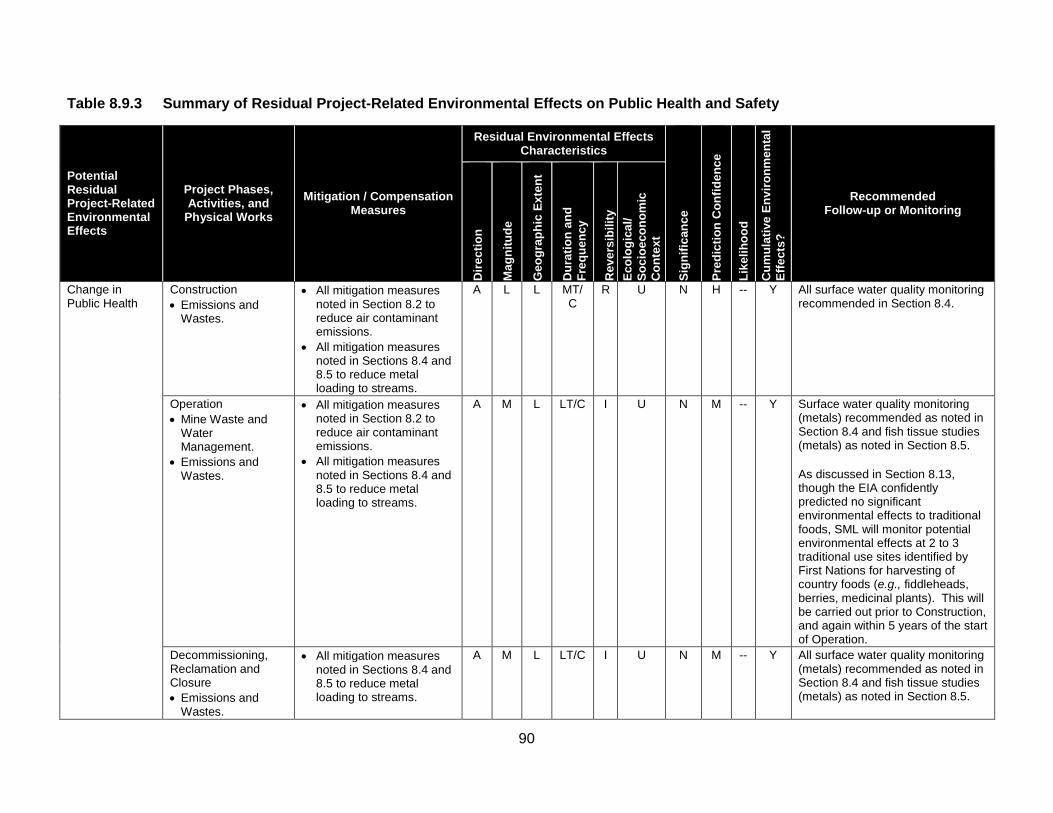
90
Table 8.9.3 Summary of Residual Project-Related Environmental Effects on Public Health and Safety
Potential Residual Project-Related Environmental Effects
Project Phases, Activities, and
Physical Works Mitigation / Compensation
Measures
Residual Environmental Effects Characteristics
Sign
ifica
nce
Pred
ictio
n C
onfid
ence
Like
lihoo
d
Cum
ulat
ive
Envi
ronm
enta
l Ef
fect
s?
Recommended Follow-up or Monitoring
Dire
ctio
n
Mag
nitu
de
Geo
grap
hic
Exte
nt
Dur
atio
n an
d Fr
eque
ncy
Rev
ersi
bilit
y Ec
olog
ical
/ So
cioe
cono
mic
C
onte
xt
Change in Public Health
Construction • Emissions and
Wastes.
• All mitigation measures noted in Section 8.2 to reduce air contaminant emissions.
• All mitigation measures noted in Sections 8.4 and 8.5 to reduce metal loading to streams.
A L L MT/C
R U N H -- Y All surface water quality monitoring recommended in Section 8.4.
Operation • Mine Waste and
Water Management.
• Emissions and Wastes.
• All mitigation measures noted in Section 8.2 to reduce air contaminant emissions.
• All mitigation measures noted in Sections 8.4 and 8.5 to reduce metal loading to streams.
A M L LT/C I U N M -- Y Surface water quality monitoring (metals) recommended as noted in Section 8.4 and fish tissue studies (metals) as noted in Section 8.5. As discussed in Section 8.13, though the EIA confidently predicted no significant environmental effects to traditional foods, SML will monitor potential environmental effects at 2 to 3 traditional use sites identified by First Nations for harvesting of country foods (e.g., fiddleheads, berries, medicinal plants). This will be carried out prior to Construction, and again within 5 years of the start of Operation.
Decommissioning, Reclamation and Closure • Emissions and
Wastes.
• All mitigation measures noted in Sections 8.4 and 8.5 to reduce metal loading to streams.
A M L LT/C I U N M -- Y All surface water quality monitoring (metals) recommended as noted in Section 8.4 and fish tissue studies (metals) as noted in Section 8.5.

91
Table 8.9.3 Summary of Residual Project-Related Environmental Effects on Public Health and Safety
Potential Residual Project-Related Environmental Effects
Project Phases, Activities, and
Physical Works Mitigation / Compensation
Measures
Residual Environmental Effects Characteristics
Sign
ifica
nce
Pred
ictio
n C
onfid
ence
Like
lihoo
d
Cum
ulat
ive
Envi
ronm
enta
l Ef
fect
s?
Recommended Follow-up or Monitoring
Dire
ctio
n
Mag
nitu
de
Geo
grap
hic
Exte
nt
Dur
atio
n an
d Fr
eque
ncy
Rev
ersi
bilit
y Ec
olog
ical
/ So
cioe
cono
mic
C
onte
xt
Residual Environmental Effects for all Phases
N M -- Y
KEY Direction P Positive. A Adverse. Magnitude N Negligible: Project-related environmental
exposures are below the benchmarks established by a recognized health organization (i.e., HQ<0.2; CR< 1.0; ILCR<1E-05) and/or do not affect the public health status.
L Low: Project-related environmental exposures are approaching the benchmarks established by a recognized health organization (i.e., 0.2<HQ≤2.0; 1.0<CR≤2.0; 1E-05<ILCR≤1E-04) and/or are unlikely to substantially change the public health status.
M Medium: Project-related environmental exposures are predicted to exceed the benchmarks established by a recognized health organization (i.e., 2.0<HQ≤10.0; 2.0<CR≤10.0; 1E-04<ILCR≤1E-03) and/or are may result in a long-term, substantive change in the public health status.
H High: Project-related environmental exposures are predicted to substantially exceed the benchmarks established by a recognized health organization (i.e., HQ>10.0; CR>10.0; ILCR>1E-03) and/or are likely to result in a long-term, substantive change in the public health status.
Geographic Extent S Site-specific: Within the
PDA. L Local: Within the LAA. R Regional: Within the RAA. Duration ST Short-term: Occurs and lasts
for short periods (e.g., days/weeks).
MT Medium-term: Occurs and lasts for extended periods of time (e.g., years).
LT Long-term: Occurs during Construction and/or Operation and lasts for the life of Project.
P Permanent: Occurs during Construction and Operation and beyond.
Frequency O Occurs once. S Occurs sporadically at
irregular intervals. R Occurs on a regular basis
and at regular intervals. C Continuous.
Reversibility R Reversible. I Irreversible. Ecological/Socioeconomic Context U Undisturbed: Area relatively or not
adversely affected by human activity.
D Developed: Area has been substantially previously disturbed by human development or human development is still present.
N/A Not Applicable. Significance S Significant. N Not Significant.
Prediction Confidence Confidence in the significance prediction, based on scientific information and statistical analysis, professional judgment and known effectiveness of mitigation: L Low level of confidence. M Moderate level of confidence. H High level of confidence. Likelihood If a significant environmental effect is predicted, the likelihood of that significant environmental effect occurring, based on professional judgment: L Low probability of occurrence. M Medium probability of occurrence. H High probability of occurrence. Cumulative Environmental Effects? Y Potential for environmental effect to interact
with the environmental effects of other past, present or foreseeable projects or activities in RAA.
N Environmental effect will not or is not likely to interact with the environmental effects of other past, present or foreseeable projects or activities in RAA.

92
Table 8.9.4 Potential Cumulative Environmental Effects to Public Health and Safety
Other Projects or Activities With Potential for Cumulative Environmental Effects
Potential Cumulative Environmental Effects Change in Public Health Change in Public Safety
Past or Present Projects or Activities That Have Been Carried Out Industrial Land Use (Past or Present) 0 0 Forestry and Agricultural Land Use (Past or Present) 0 0 Current Use of Land and Resources for Traditional Purposes by Aboriginal Persons (Past or Present) 0 0
Recreational Land Use (Past or Present) 0 0 Residential Land Use (Past or Present) 0 0 Future Projects or Activities That Will Be Carried Out Industrial Land Use (Future) 1 0 Forestry and Agricultural Land Use (Future) 1 0 Current Use of Land and Resources for Traditional Purposes by Aboriginal Persons (Future) 0 0
Recreational Land Use (Future) 0 0 Planned Residential Development (Future) 1 0 Cumulative Environmental Effects Notes: Cumulative environmental effects were ranked as follows: 0 Project environmental effects do not act cumulatively with those of other Projects and Activities. 1 Project environmental effects act cumulatively with those of other Project and Activities, but are unlikely to result in significant
cumulative environmental effects OR Project environmental effects act cumulatively with existing significant levels of cumulative environmental effects but will not measurably change the state of the VEC.
2 Project environmental effects act cumulatively with those of other project and activities, and may result in significant cumulative environmental effects OR Project environmental effects act cumulatively with existing significant levels of cumulative environmental effects and may measurably change the state of the VEC.
8.10 – Labour and Economy
This section’s narrative text describes the VEC concerned; summarizes how the effects assessment was carried out, and reports its conclusions. Section 8.10 presents this information under the following headings and opens with a summary statement. 8.10 Labour and Economy 8.10.1 Scope of Assessment 8.10.1.1 Rationale for Selection of Valued Environmental Component, Regulatory Context, and Issues
Raised During Engagement 8.10.1.2 Selection of Environmental Effects and Measurable Parameters 8.10.1.3 Temporal Boundaries 8.10.1.4 Spatial Boundaries 8.10.1.5 Administrative and Technical Boundaries 8.10.1.6 Residual Environmental Effects Significance Criteria 8.10.2 Existing Conditions 8.10.2.1 Population Demographics 8.10.2.2 Economy 8.10.2.2.1 New Brunswick 8.10.2.2.2 York County 8.10.2.2.3 Carleton County 8.10.2.3 Labour 8.10.2.3.1 New Brunswick 8.10.2.3.2 York County

93
8.10.2.3.3 Carleton County 8.10.2.4 Aboriginal Employment 8.10.3 Potential Project-VEC Interactions 8.10.4 Assessment of Project-Related Environmental Effects 8.10.4.1 Potential Project Environmental Effects Mechanisms 8.10.4.2 Mitigation of Project Environmental Effects 8.10.4.3 Characterization of Residual Project Environmental Effects 8.10.5 Assessment of Cumulative Environmental Effects 8.10.6 Determination of Significance 8.10.6.1 Residual Project Environmental Effects 8.10.6.2 Residual Cumulative Environmental Effects 8.10.7 Follow-up or Monitoring Summary Statement - Labour and Economy
The opening summary statement for Section 8.10 begins on Page 8-485. It explains that Labour and Economy refers to the labour market and availability, employment, employment income and business income, and their aggregate environmental effects on taxes and such indicators as the provincial gross domestic product (GDP).
The Report notes that that Labour and Economy is a VEC because the Project would generate benefits to local, regional, and provincial economies during Construction and Operation through expenditures, employment, taxation, royalties, and other direct, indirect, and induced benefits to the local, regional, and provincial economies.
The Report states that these benefits could also result in potential adverse environmental effects from employment and spending that could require management to optimize overall benefit. The Report notes that potential positive and adverse environmental effects on Labour and Economy have been the subject of both public and regulatory interest and consultation, which informed the scope of assessment.
It explains that the Project has potential to generate adverse residual environmental effects on Labour and Economy by creating increased demand for labour, goods, and services. If Project demand for skilled labour were to exceed supply, labour market competition could cause wage inflation and labour shortages.
Similarly, Project-related demand for goods and services has potential to exceed the capacity of local and regional supply, resulting in price inflation, and reduced availability of goods and services for other projects and economic sectors. The Report states, however, it is anticipated that the existing and forecast supply of labour, goods, and services would be sufficient to meet Project demand and those of other future projects or activities.
It adds that the Project would generate considerable benefits to local, regional, and provincial economies through the generation of employment, incomes, taxes, and GDP. These benefits would result directly from the Project, while indirect and induced benefits would accrue through economic spin-off related to the Project.
An estimate of the economic benefits generated by the Project was made using an economic model (EcoTec 2013) that predicts Project expenditures throughout the regional, provincial, and national

94
economies. Based on this model, it is estimated that direct employment for Construction (2 years) and Operation (27 years) would reach 9,826 person-years over its lifetime, over 90% of which would be created in New Brunswick.
Including direct, indirect, and induced employment, the Project would support an estimated 32,619 person-years of employment, with 16,406 person-years of that employment directly within New Brunswick.
The expected direct, indirect, and induced GDP generated over the life of the Project would be $5.91 billion, including $3.75 billion (63.5%) of that total contributing directly to the New Brunswick economy. The direct, indirect, and induced GDP generated by the Project in New Brunswick would be approximately $2.76 billion, $474.4 million, and $522.6 million, respectively.
The Project would also contribute substantially to tax revenue provincially and federally. In total, the Project would generate an estimated $1.78 billion in tax over its lifetime, of which $742.9 million (41.7%) would go to the Province of New Brunswick. The Report states that based on the magnitude of these economic benefits, the Project is expected to generate significant positive environmental effects on Economy during Construction and Operation.
During Decommissioning, Reclamation and Closure, there would be minor positive environmental effects through some additional employment; however, these environmental effects were rated not significant due to the reduced magnitude of economic benefits.
Potential adverse environmental effects on a Change in Economy related to local price inflation and goods and services supply were assessed and rated not significant for all Project phases. It is anticipated that the existing business capacity of the local, regional, and provincial economies would be able to meet the Project demand for goods and services. While the Project would generate substantial economic benefits by awarding contracts to businesses within the LAA and the rest of the province, it is expected that goods and services required in New Brunswick would not exceed supply or lead to price inflation or goods and services shortages.
The Report states that adverse environmental effects on a Change in Labour (i.e., wage inflation and labour shortage) were rated not significant for all Project phases. Given current labour market conditions in the LAA, and local interest in employment opportunities that has been expressed through consultation activities, it is anticipated that there would be a considerable supply of labour from the LAA for all Project phases.
In addition, while SML intends to promote a proactive local employment strategy, it is expected that the Project would also employ New Brunswickers (including First Nations) from outside the region, as well as from other areas. As such, it is not expected that Project labour demands would cause a highly competitive labour market leading to wage inflation or labour shortages.
A total of 15 tables and 4 illustrative figures are included in Section 8.10 and listed below:

95
Tables Table 8.10.1 Measurable Parameters for Labour and Economy Table 8.10.2 Gross Domestic Product (GDP), New Brunswick, 2001 to 2010 Table 8.10.3 Labour Force Characteristics: New Brunswick, York and Carleton Counties, 2006 Table 8.10.4 Labour Force Characteristics: New Brunswick, ork and Carleton Counties – Aboriginal Identify Population (2013) Table 8.10.5 Experienced Aboriginal Labor Force by Industry, Province of New Brunswick (2011) Table 8.10.6 Experienced Aboriginal Labour Force by Occupation, New Brunswick (2011) Table 8.10.7 Potential Project environmental Effects to Labour and Economy Table 8.10.8 Summary of Residual Project-Related Environmental Effects on Labour and Evonomy Table 8.10.9 Employment Generated During Construction Table 8.10.10 Tax Revenues Generated During Constructin ($ Millions) Table 8.10.11 Economic Activity Generated During Construction, as GDP ($ Millions) Table 8.10.12 Employment Generated During Operation Table 8.10.13 Tax Revenues Generated During Operation Expenditures ($ Millions) Table 8.10.14 Economic Activity Generated During Operation, as GDP ($ Millions) Table 8.10.15 Potential Cumulative Environmental Effects to Labour and Economy Figures Figure 8.10.1 Project Development Area (PDA), and Local Assessment Area (LAA) for Labour and Economy Figure 8.10.2 Education Level, New Brunswick, 2006 Figure 8.10.3 Education Level, York County, 2006 Figure 8.10.4 Education Level, Carleton County, 2006
Table 8.10.8 is reproduced below and summarizes the Residual Project-Related Environmental Effects on Labour and Economy; mitigation or compensation measures proposed by the Study Team; characteristics of the residual effects, and recommended follow-up or monitoring. Table 8.10.15 is reproduced below as well. It details and ranks Potential Cumulative Environmental Effects on Labour and Economy.

96
Table 8.10.8 Summary of Residual Project-Related Environmental Effects on Labour and Economy
Potential Residual Project-Related Environmental Effects
Project Phases, Activities, and
Physical Works Mitigation / Compensation
Measures
Residual Environmental Effects Characteristics
Sign
ifica
nce
Pred
ictio
n C
onfid
ence
Like
lihoo
d
Cum
ulat
ive
Envi
ronm
enta
l Ef
fect
s?
Recommended Follow-up or Monitoring
Dire
ctio
n
Mag
nitu
de
Geo
grap
hic
Exte
nt
Dur
atio
n an
d Fr
eque
ncy
Rev
ersi
bilit
y
Ecol
ogic
al/
Soci
oeco
nom
ic
Con
text
Change in Economy
Construction • Employment and
Expenditure
Mitigation to be implemented during Construction and Operation will be as follows. • Qualified local workers will be given
priority consideration for Project employment.
• SML will work with local education and training institutions and communicate work requirements to improve the availability of appropriate programs, allowing local people opportunities to gain qualifications for employment.
• Local companies will be given preference for site contract work where qualified companies and suppliers can be identified.
• SML will work with the local business community to communicate requirements and expectations for contracting opportunities and to identify new Project-related business opportunities for local companies.
• SML will continue to engage with the public throughout Operation, allowing sufficient time to plan for and mitigate any adverse environmental effects on Economy that may occur during Decommissioning, Reclamation and Closure.
P H L/R
MT/C
R D S
H
H Y
None recommended
Operation • Employment and
Expenditure
P H L/R
LT/C
R D S
H
H Y

97
Table 8.10.8 Summary of Residual Project-Related Environmental Effects on Labour and Economy
Potential Residual Project-Related Environmental Effects
Project Phases, Activities, and
Physical Works Mitigation / Compensation
Measures
Residual Environmental Effects Characteristics
Sign
ifica
nce
Pred
ictio
n C
onfid
ence
Like
lihoo
d
Cum
ulat
ive
Envi
ronm
enta
l Ef
fect
s?
Recommended Follow-up or Monitoring
Dire
ctio
n
Mag
nitu
de
Geo
grap
hic
Exte
nt
Dur
atio
n an
d Fr
eque
ncy
Rev
ersi
bilit
y
Ecol
ogic
al/
Soci
oeco
nom
ic
Con
text
Decommissioning, Reclamation and Closure • Employment and
Expenditure
• SML will continue to engage with the public throughout its planning procedures for Decommissioning, Reclamation and Closure, allowing optimal time to plan for and mitigate environmental effects.
P
M
L/R
MT/C
R D N H - Y
Residual Environmental Effects for all Phases
S H H Y
KEY Direction P Positive. A Adverse. Magnitude L Low: Environmental effects limited
to specific businesses and trades directly required by the Project.
M Moderate: Environmental effects felt by businesses and labour directly and indirectly related to Project.
H High: Environmental effects felt broadly by businesses and labour throughout the economy.
Geographic Extent S Site-specific: Within the PDA. L Local: Within the LAA. R Regional: Within the RAA.
Duration ST Short-term: Occurs and lasts for
short periods (e.g., days/weeks).
MT Medium-term: Occurs and lasts for extended periods of time (e.g., years).
LT Long-term: Occurs during Construction and/or Operation and lasts for the life of Project.
P Permanent: Occurs during Construction and Operation and beyond.
Frequency O Occurs once. S Occurs sporadically at irregular
intervals. R Occurs on a regular basis and at
regular intervals. C Continuous.
Reversibility R Reversible. I Irreversible. Ecological/Socioeconomic
Context U Undisturbed: Area
relatively or not adversely affected by human activity.
D Developed: Area has been substantially previously disturbed by human development or human development is still present.
N/A Not Applicable. Significance S Significant. N Not Significant.
Prediction Confidence Confidence in the significance prediction, based on scientific information and statistical analysis, professional judgment and known effectiveness of mitigation: L Low level of confidence. M Moderate level of confidence. H High level of confidence. Likelihood If a significant environmental effect is predicted, the likelihood of that significant environmental effect occurring, based on professional judgment: L Low probability of occurrence. M Medium probability of occurrence. H High probability of occurrence. Cumulative Environmental Effects? Y Potential for environmental effect to interact with the environmental effects of
other past, present or foreseeable projects or activities in RAA. N Environmental effect will not or is not likely to interact with the environmental
effects of other past, present or foreseeable projects or activities in RAA.
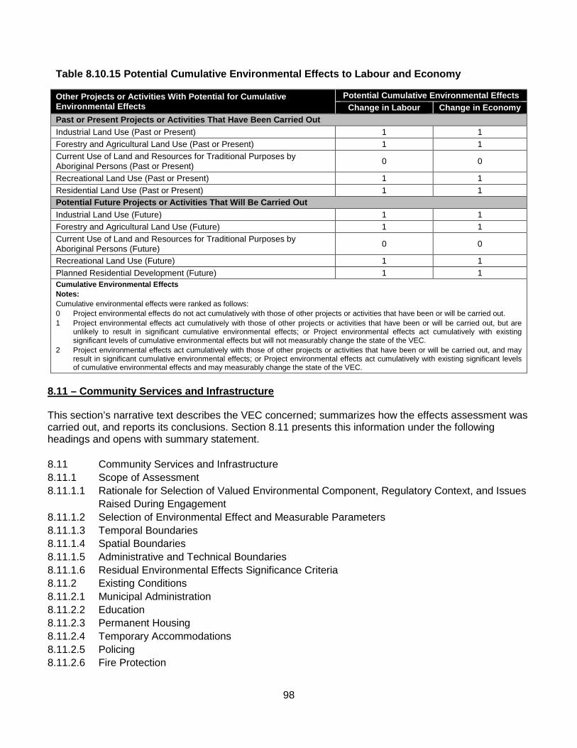
98
Table 8.10.15 Potential Cumulative Environmental Effects to Labour and Economy
Other Projects or Activities With Potential for Cumulative Environmental Effects
Potential Cumulative Environmental Effects Change in Labour Change in Economy
Past or Present Projects or Activities That Have Been Carried Out Industrial Land Use (Past or Present) 1 1 Forestry and Agricultural Land Use (Past or Present) 1 1 Current Use of Land and Resources for Traditional Purposes by Aboriginal Persons (Past or Present) 0 0
Recreational Land Use (Past or Present) 1 1 Residential Land Use (Past or Present) 1 1 Potential Future Projects or Activities That Will Be Carried Out Industrial Land Use (Future) 1 1 Forestry and Agricultural Land Use (Future) 1 1 Current Use of Land and Resources for Traditional Purposes by Aboriginal Persons (Future) 0 0
Recreational Land Use (Future) 1 1 Planned Residential Development (Future) 1 1 Cumulative Environmental Effects Notes: Cumulative environmental effects were ranked as follows: 0 Project environmental effects do not act cumulatively with those of other projects or activities that have been or will be carried out. 1 Project environmental effects act cumulatively with those of other projects or activities that have been or will be carried out, but are
unlikely to result in significant cumulative environmental effects; or Project environmental effects act cumulatively with existing significant levels of cumulative environmental effects but will not measurably change the state of the VEC.
2 Project environmental effects act cumulatively with those of other projects or activities that have been or will be carried out, and may result in significant cumulative environmental effects; or Project environmental effects act cumulatively with existing significant levels of cumulative environmental effects and may measurably change the state of the VEC.
8.11 – Community Services and Infrastructure This section’s narrative text describes the VEC concerned; summarizes how the effects assessment was carried out, and reports its conclusions. Section 8.11 presents this information under the following headings and opens with summary statement. 8.11 Community Services and Infrastructure 8.11.1 Scope of Assessment 8.11.1.1 Rationale for Selection of Valued Environmental Component, Regulatory Context, and Issues Raised During Engagement 8.11.1.2 Selection of Environmental Effect and Measurable Parameters 8.11.1.3 Temporal Boundaries 8.11.1.4 Spatial Boundaries 8.11.1.5 Administrative and Technical Boundaries 8.11.1.6 Residual Environmental Effects Significance Criteria 8.11.2 Existing Conditions 8.11.2.1 Municipal Administration 8.11.2.2 Education 8.11.2.3 Permanent Housing 8.11.2.4 Temporary Accommodations 8.11.2.5 Policing 8.11.2.6 Fire Protection

99
8.11.2.7 Community Health 8.11.2.8 Recreation and Entertainment 8.11.3 Potential Project-VEC Interactions 8.11.4 Assessment of Project-Related Environmental Effects 8.11.4.1 Potential Project Environmental Effects Mechanisms 8.11.4.2 Mitigation of Project Environmental Effects 8.11.4.3 Characterization of Residual Project Environmental Effects 8.11.5 Assessment of Cumulative Environmental Effects 8.11.6 Determination of Significance 8.11.6.1 Residual Project Environmental Effects 8.11.6.2 Residual Cumulative Environmental Effects 8.11.7 Follow-up or Monitoring
Summary Statement - Community Services and Infrastructure
The opening summary statement for Section 8.11 begins on Page 8-517. It explains that Community Services and Infrastructure refers to the public services and infrastructure that are provided to local populations through various public and governmental programs, as well as the services provided by businesses and organizations to meet societal needs.
The Report notes that Community Services and Infrastructure was selected as a VEC because the Project has the potential to affect community services and infrastructure and the ability of nearby communities in central New Brunswick to deliver these to the public.
It states that the environmental effects on Community Services and Infrastructure, both adverse and positive, would derive largely from the Project’s economic effects through employment and demands on business, services, and infrastructure, such as medical facilities and accommodation. This includes the environmental effects of any Project-related in-migration by workers and their families. It notes that SML would implement a comprehensive Environmental and Social Management System (ESMS) (Appendix D) to avoid or reduce adverse environmental effects and enhance positive environmental effects.
The environmental effects on Community Services and Infrastructure were assessed for five measurable parameters: capacity of housing; accommodations and building lot availability; capacity of policing and fire services and infrastructure; capacity of health facilities and emergency services and infrastructure; and capacity of recreational and entertainment facilities.
To provide context for the assessment, existing Community Services and Infrastructure conditions are discussed for New Brunswick as a whole, and for York County and Carleton County. This includes an overview of: municipal administration; the education system and its capacity for additional students; the current supply of permanent and temporary accommodations, as well as land available for residential development; policing and fire services and infrastructure; health and emergency services and infrastructure; and recreation and entertainment venues, including eating establishments.
Construction of the Project would last approximately 2 years and generate up to approximately 500 direct jobs at the peak of Construction activity. Some of these employees may currently reside within the Project area, and others would either commute from nearby communities or move to the region, primarily on a temporary basis, as specialized skills will be required for certain positions. This population increase
100
would place additional demands on Community Services and Infrastructure, particularly temporary accommodations since construction workers tend not to settle in the Project area.
The vacancy rate in the Fredericton area (the largest urban centre nearest to the Project) is already the lowest in the province; however, these environmental effects are not expected to be significant, since the workforce demands would be dispersed throughout the communities in the region. During Construction, SML would provide bussing to and from the Project site to facilitate dispersal of the temporary housing demand over the region, and otherwise work with communities to adapt to this demand through processes included in the ESMS.
The Report states that Operation would generate up to 300 direct jobs over an estimated 27-year mine life. As with Construction, certain employees would likely be specialized and originate from communities outside of the central New Brunswick region. Since this phase could last up to 27 years, it is likely that these in-migrant workers and their families would settle in central New Brunswick and place additional demands on existing services and infrastructure.
The Report notes that the local housing market appears to have capacity to absorb new residents, as there appears to be a good supply of new and resale homes in the Fredericton area and land available for residential development in some of the other nearby communities in central New Brunswick. Therefore, any adverse environmental effects on the housing market would not be significant.
Environmental effects of in-migration on health facilities and emergency services and infrastructure and police and fire services and infrastructure during Construction and Operation are not expected to be significant, since the workforce would be dispersed throughout central New Brunswick and there would be emergency fire and medical response resources at the Project site. The Report notes that Project workers would place additional demands on recreation and entertainment facilities in the region; however this would be dispersed throughout central New Brunswick and the facilities in the area are expected to have the capacity for additional demand created by new residents.
Throughout all Project phases, and as described in the ESMS, the Report states that SML would consult regularly with the applicable agencies, organizations and communities to provide Project information and to identify and address potential Project-related implications for local services and infrastructure. SML would also work with local communities to assist them in appreciating and responding to the Project in ways that contribute to the sustainable development of their communities.
A total of 6 tables and 1 illustrative figure is included in Section 8.11 and listed below: Tables Table 8.11.1 Measurable Parameters for Community Services and Infrastructure Table 8.11.2 Number of Physicians at Healthcare Facilities in the LAA Table 8.11.3 Recreational Facilities, Fredericton Table 8.11.4 Potential Project Environmental Effects to Community Services and Infrastructure Table 8.11.5 Summary of Residual Project-Related Environmental Effects on Community Services and Infrastructure Table 8.11.6 Potential Cumulative Environmental Effects to Community Services and Infrastructure

101
Figures Figure 8.11.1 Project Development Area (PDA), Local Assessment Area (LAA), and Regional Assessment Area (RAA) for Community Services and Infrastructure Table 8.11.5 is reproduced below and summarizes the Residual Project-Related Environmental Effects on Community Services and Infrastructure; mitigation or compensation measures proposed by the Study Team; characteristics of the residual effects, and recommended follow-up or monitoring. Table 8.11.6 is reproduced below as well. It details and ranks Potential Cumulative Environmental Effects on Public Health and Safety.
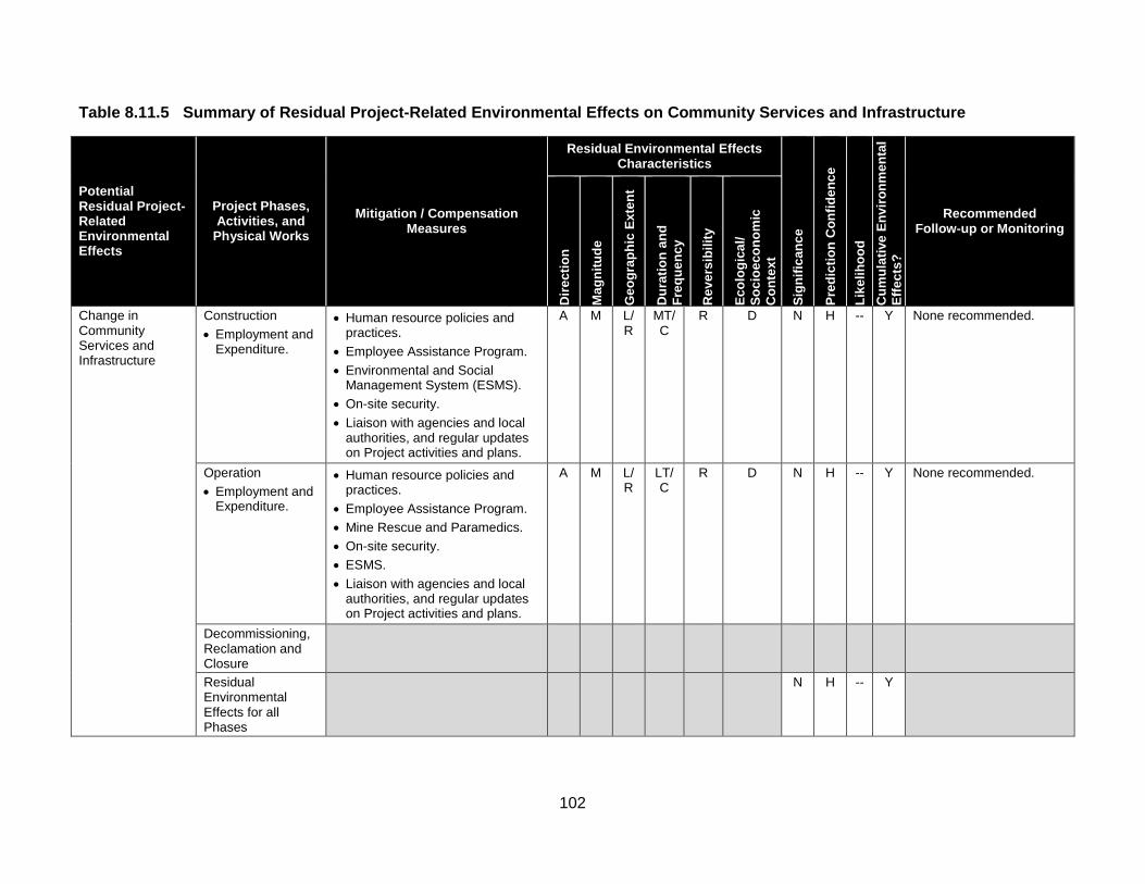
102
Table 8.11.5 Summary of Residual Project-Related Environmental Effects on Community Services and Infrastructure
Potential Residual Project-Related Environmental Effects
Project Phases, Activities, and
Physical Works Mitigation / Compensation
Measures
Residual Environmental Effects Characteristics
Sign
ifica
nce
Pred
ictio
n C
onfid
ence
Like
lihoo
d C
umul
ativ
e En
viro
nmen
tal
Effe
cts?
Recommended Follow-up or Monitoring
Dire
ctio
n
Mag
nitu
de
Geo
grap
hic
Exte
nt
Dur
atio
n an
d Fr
eque
ncy
Rev
ersi
bilit
y
Ecol
ogic
al/
Soci
oeco
nom
ic
Con
text
Change in Community Services and Infrastructure
Construction • Employment and
Expenditure.
• Human resource policies and practices.
• Employee Assistance Program. • Environmental and Social
Management System (ESMS). • On-site security. • Liaison with agencies and local
authorities, and regular updates on Project activities and plans.
A M L/R
MT/C
R D N H -- Y None recommended.
Operation • Employment and
Expenditure.
• Human resource policies and practices.
• Employee Assistance Program. • Mine Rescue and Paramedics. • On-site security. • ESMS. • Liaison with agencies and local
authorities, and regular updates on Project activities and plans.
A M L/R
LT/C
R D N H -- Y None recommended.
Decommissioning, Reclamation and Closure
Residual Environmental Effects for all Phases
N H -- Y

103
Table 8.11.5 Summary of Residual Project-Related Environmental Effects on Community Services and Infrastructure
Potential Residual Project-Related Environmental Effects
Project Phases, Activities, and
Physical Works Mitigation / Compensation
Measures
Residual Environmental Effects Characteristics
Sign
ifica
nce
Pred
ictio
n C
onfid
ence
Like
lihoo
d C
umul
ativ
e En
viro
nmen
tal
Effe
cts?
Recommended Follow-up or Monitoring
Dire
ctio
n
Mag
nitu
de
Geo
grap
hic
Exte
nt
Dur
atio
n an
d Fr
eque
ncy
Rev
ersi
bilit
y
Ecol
ogic
al/
Soci
oeco
nom
ic
Con
text
KEY Direction P Positive. A Adverse. Magnitude L Low: within current capacity, standard or
threshold. M Medium: approaches current capacity,
standard or threshold. H High: exceeds current capacity, standard
or threshold. Geographic Extent S Site-specific: Within the PDA. L Local: Within the LAA. R Regional: Within the RAA.
Duration ST Short-term: Occurs and lasts for
short periods (e.g., days/weeks). MT Medium-term: Occurs and lasts for
extended periods of time (e.g., years).
LT Long-term: Occurs during Construction and/or Operation and lasts for the life of Project.
P Permanent: Occurs during Construction and Operation and beyond.
Frequency O Occurs once. S Occurs sporadically at irregular
intervals. R Occurs on a regular basis and at
regular intervals. C Continuous.
Reversibility R Reversible. I Irreversible. Ecological/Socioeconomic Context U Undisturbed: Area relatively or not
adversely affected by human activity. D Developed: Area has been substantially
previously disturbed by human development or human development is still present.
N/A Not Applicable. Significance S Significant. N Not Significant.
Prediction Confidence Confidence in the significance prediction, based on scientific information and statistical analysis, professional judgment and known effectiveness of mitigation: L Low level of confidence. M Moderate level of confidence. H High level of confidence. Likelihood If a significant environmental effect is predicted, the likelihood of that significant environmental effect occurring is determined, based on professional judgment: L Low probability of occurrence. M Medium probability of occurrence. H High probability of occurrence. Cumulative Environmental Effects? Y Potential for environmental effect to
interact with the environmental effects of other past, present or foreseeable future projects or activities in RAA.
N Environmental effect will not or is not likely to interact with the environmental effects of other past, present or foreseeable future projects or activities in RAA.

104
Table 8.11.6 Potential Cumulative Environmental Effects to Community Services and Infrastructure
Other Projects or Activities With Potential for Cumulative Environmental Effects
Potential Cumulative Environmental Effects Change in Community Services and
Infrastructure Past or Present Projects or Activities That Have Been Carried Out Industrial Land Use (Past or Present) 0 Forestry and Agricultural Land Use (Past or Present) 0 Current Use of Land and Resources for Traditional Purposes by Aboriginal Persons (Past or Present) 0
Recreational Land Use (Past or Present) 0 Residential Land Use (Past or Present) 0 Potential Future Projects or Activities That Will Be Carried Out Industrial Land Use (Future) 0 Forestry and Agricultural Land Use (Future) 1 Current Use of Land and Resources for Traditional Purposes by Aboriginal Persons (Future) 0
Recreational Land Use (Future) 0 Planned Residential Development (Future) 1 Cumulative Environmental Effects Notes: Cumulative environmental effects were ranked as follows: 0 Project environmental effects do not act cumulatively with those of other projects or activities that have been or will be carried out. 1 Project environmental effects act cumulatively with those of other projects or activities that have been or will be carried out, but are
unlikely to result in significant cumulative environmental effects; or Project environmental effects act cumulatively with existing significant levels of cumulative environmental effects but will not measurably change the state of the VEC.
2 Project environmental effects act cumulatively with those of other projects or activities that have been or will be carried out, and may result in significant cumulative environmental effects; or Project environmental effects act cumulatively with existing significant levels of cumulative environmental effects and may measurably change the state of the VEC.
8.12 – Land and Resource Use This section’s narrative text describes the VEC concerned; summarizes how the effects assessment was carried out, and reports its conclusions. Section 8.12 presents this information under the following headings and opens with a summary statement. 8.12 Land and Resource Use 8.12.1 Scope of Assessment 8.12.1.1 Rationale for Selection of Valued Environmental Component, Regulatory Context, and Issues
Raised During Engagement 8.12.1.2 Selection of Environmental Effect and Measurable Parameters 8.12.1.3 Temporal Boundaries 8.12.1.4 Spatial Boundaries 8.12.1.5 Administrative and Technical Boundaries 8.12.1.6 Residual Environmental Effects Significance Criteria 8.12.2 Existing Conditions 8.12.3 Potential Project-VEC Interactions 8.12.4 Assessment of Project-Related Environmental Effects 8.12.4.1 Potential Project Environmental Effects Mechanisms 8.12.4.2 Mitigation of Project Environmental Effects 8.12.4.3 Characterization of Residual Project Environmental Effects 8.12.5 Assessment of Cumulative Environmental Effects

105
8.12.6 Determination of Significance 8.12.6.1 Residual Project Environmental Effects 8.12.6.2 Residual Cumulative Environmental Effects 8.12.7 Follow-up Monitoring Summary Statement - Land and Resource Use
The opening summary statement for Section 8.12 begins on Page 8-547. It explains that Land and Resource Use, as a VEC, includes current and future proposed occupation, and public and private use, of the lands and resources within and adjacent to the PDA for the Project. It notes that Land and Resource Use was selected as a VEC because of the potential for interactions between the Project and the use of the land and resources in the PDA and their intrinsic value for recreation, sustenance, industry, economic development, and other purposes. The focus of this VEC is on the environmental effects on Land and Resource Use in the central New Brunswick region and the rural communities in that region; the recreational campsite leases (some of which include cabins) near the Project, and for non-Aboriginal New Brunswickers The Report states that the potential of the Project to result in a change in Land and Resource Use was evaluated using several measurable parameters including the Project footprint, change in sound level, change in air quality, total area with changed viewshed, and change in property values. Emphasis was placed on the recreational use and enjoyment of land and resources in and around the PDA. It notes that the Project would change the primary land use within the PDA from primarily forestry to industrial mining. As the Project would be located on Crown land and result in substantive economic benefits to New Brunswick, the Report states that this land use appears to be an acceptable use of Crown land according to the New Brunswick Department of Natural Resource’s Crown Land Management Principles (NBDNR 2010).
The Project would also result in a loss of recreational land use that occurs at the convenience of the Crown within the PDA. However, land in the surrounding areas has the capacity to accommodate any recreational land use that is displaced by the Project. As the closest permanent residence is approximately 10 km from the Project, localized sound and air emissions are unlikely to result in nuisance-related environmental effects.
The Report notes that recreational cabins are located approximately 1.5 km to the east of the open pit location. However, nuisance environmental effects on recreational cabins and other human uses of the land and resources in the area, as a result of air contaminant and sound emissions, are not expected to be substantive.
It states that project components like the open pit and tailings storage facility (TSF) could alter the nature of the local viewshed substantively, compared to its current condition. But residual environmental effects would be low in magnitude, as the Project would only be visible from a small number of local receptors, and would not be visible from the nearby recreational campsites or from any permanent residence.
The Report states that the environmental effect on property values due to the Project is also expected to be low in magnitude and localized; although actual changes to property values are difficult to predict

106
because of the multiple contributing factors such as local market conditions, economic conditions, and the social and cultural context.
With mitigation, including communication with Crown timber license holders, maintenance of vegetated buffers, and communication with recreational campsite lease holders, The Report states that the residual environmental effects of the Project on Land and Resource Use have been rated not significant.
A total of 4 tables and 16 illustrative figures are included in Section 8.12 and listed below: Tables Table 8.12.1 Measurable Parameters for Land and Resource Use Table 8.12.2 Potential Project Environmental Effects to Land and Resource Use Table 8.12.3 Summary of Residual Project-Related Environmental Effects on Land and Resource Use Table 8.12.4 Potential Cumulative Environmental Effects to Land and Resource Use Figures Figure 8.12.1 Project Development Area (PDA), and Local Assessment Area (LAA) for Land and Resource Use Figure 8.12.2 Regional Assessment Area (RAA) for Land and Resource Use Figure 8.12.3 Location and Direction of Photographs of the PDA Figure 8.12.4 Photograph Looking West Toward PDA from Napadogan (Photo 1 in Figure 8.12.3) Figure 8.12.5 Photograph Taken Within PDA, Looking Northwest Toward Future Location of TSF (Photo 2 in Figure 8.12.3) Figure 8.12.6 Photograph Taken Along Existing 345 kV Electrical Transmission Line, Looking Northwest Toward the PDA (Photo 3 in Figure 8.12.3) Figure 8.12.7 Photograph Taken from Chainy Lakes Road, Looking North Toward the PDA (Photo 4 in figure 8.12.3) Figure 8.12.8 Photograph Taken Along Four Mile Brook Road, Looking South Toward the TSF (Photo 5 in figure 8.12.3) Figure 8.12.9 Viewshed Map Figure 8.12.10 Modelled View from Napadogan, Looking West Toward PDA (from Photo 1 in Figure 8.12.3, inset) Figure 8.12.11 Modelled View from Within PDA, Looking Nortwest Toward TSF (from Photo 2 in Figure 8.12.3, inset) Figure 8.12.12 Modelled View Looking Northwest Toward Open Pit and TSF (from Photo 3 in Figure 8.12.3, inset) Figure 8.12.13 Modelled View From Chainy Lakes Road, Looking North Toward TSF (from Photo 4 in Figure 8.12.3, inset) Figure 8.12.14 Modelled View From Four Mile Brook, Looking South toward TSF (from Photo 5 in Figure 8.12.3, inset) Figure 8.12.15 Modelled View From Top of Crabbe Mountain, Looking North Toward Project Figure 8.12.16 Agricultural Land in the Vicinity of the New 138 kV Transmission Line Table 8.12.3 is reproduced below and summarizes the Residual Project-Related Environmental Effects on Land and Resource Use; mitigation or compensation measures proposed by the Study Team; characteristics of the residual effects, and recommended follow-up or monitoring.

107
Table 8.12.4 is reproduced below as well. It details and ranks Potential Cumulative Environmental Effects on Land and Resource Use.

108
Table 8.12.3 Summary of Residual Project-Related Environmental Effects on Land and Resource Use
Potential Residual Project-Related Environmental Effects
Project Phases, Activities, and
Physical Works Mitigation / Compensation Measures
Residual Environmental Effects Characteristics
Sign
ifica
nce
Pred
ictio
n C
onfid
ence
Like
lihoo
d
Cum
ulat
ive
Envi
ronm
enta
l Ef
fect
s?
Recommended Follow-up or Monitoring
Dire
ctio
n
Mag
nitu
de
Geo
grap
hic
Exte
nt
Dur
atio
n an
d Fr
eque
ncy
Rev
ersi
bilit
y
Ecol
ogic
al/
Soci
oeco
nom
ic
Con
text
Change in Land and Resource Use
Construction • Site Preparation
of Open Pit, TSF, and Buildings and Ancillary Facilities.
• Physical Construction and Installation of Project Facilities.
• Physical Construction of Transmission Lines and Associated Infrastructure.
• Physical Construction of Realigned Fire Road, New Site Access Road, and Internal Site Roads.
• Forestry management plans will be revised by Crown licensees to incorporate the harvesting of forestry resources in the PDA as part of Site Preparation. Northcliff will provide information to licensees well in advance of Construction to facilitate planning in collaboration with NBDNR.
• Where possible in accessible areas (i.e., along cleared right-of-ways), trees and other vegetation will be left in place or encouraged to grow to obstruct the view of Project facilities, reducing the change in the nature of the viewshed and muffling nuisance noise.
• The Proponent will communicate with local campsite and land owners regarding Project schedule, and the timing of blasting events to minimize surprise and nuisance.
• Mitigation measures and guidelines outlined in the Environmental and Social Management System (ESMS) to reduce nuisance noise and air contaminant emissions, and changes to the viewshed.
• No trespassing signs will be posted along the perimeter of the Project site to alert local land users of the presence of the Project and its facilities.
• Additional mitigation measures relating to air and sound emissions are described in Section 8.2 (Atmospheric Environment) and Section 8.3 (Acoustic Environment).
A L L MT/C
R D N H -- N None recommended.
Operation • Mining. • Mine Waste and
Water Management.
A L L LT/C
R D N H -- Y None recommended.

109
Table 8.12.3 Summary of Residual Project-Related Environmental Effects on Land and Resource Use
Potential Residual Project-Related Environmental Effects
Project Phases, Activities, and
Physical Works Mitigation / Compensation Measures
Residual Environmental Effects Characteristics
Sign
ifica
nce
Pred
ictio
n C
onfid
ence
Like
lihoo
d
Cum
ulat
ive
Envi
ronm
enta
l Ef
fect
s?
Recommended Follow-up or Monitoring
Dire
ctio
n
Mag
nitu
de
Geo
grap
hic
Exte
nt
Dur
atio
n an
d Fr
eque
ncy
Rev
ersi
bilit
y
Ecol
ogic
al/
Soci
oeco
nom
ic
Con
text
Decommissioning, Reclamation and Closure
Residual Environmental Effects for all Phases
N H -- Y
KEY Direction P Positive. A Adverse. Magnitude L Low: Adjacent land and resource use activities are not
affected by the Project, and/or land and resource use of specific groups are not restricted or degraded and can continue.
M Medium: Adjacent land and resource use activities are affected by the Project but can continue, and/or land and resource use activities of specific groups are restricted or degraded but can continue if mitigation or compensation is applied.
H High: Land and resource uses are incompatible with adjacent land use activities, and/or land and resource use of a broad range of groups is restricted or degraded such that they cannot continue and for which the environmental effects are not mitigated or compensated.
Geographic Extent S Site-specific: Within the PDA. L Local: Within the LAA. R Regional: Within the RAA.
Duration ST Short term: Occurs and
lasts for short periods (e.g., days/weeks).
MT Medium term: Occurs and lasts for extended periods of time (e.g., years).
LT Long term: Occurs during Construction and/or Operation and lasts for the life of Project.
P Permanent: Occurs during Construction and Operation and beyond.
Frequency O Occurs once. S Occurs sporadically at
irregular intervals. R Occurs on a regular basis
and at regular intervals. C Continuous.
Reversibility R Reversible. I Irreversible. Ecological/Socioeconomic Context U Undisturbed: Area
relatively or not adversely affected by human activity.
D Developed: Area has been substantially previously disturbed by human development or human development is still present.
N/A Not Applicable. Significance S Significant. N Not Significant.
Prediction Confidence Confidence in the significance prediction, based on scientific information and statistical analysis, professional judgment and known effectiveness of mitigation: L Low level of confidence. M Moderate level of confidence. H High level of confidence. Likelihood If a significant environmental effect is predicted, the likelihood of that significant environmental effect occurring, based on professional judgment: L Low probability of occurrence. M Medium probability of occurrence. H High probability of occurrence. Cumulative Environmental Effects? Y Potential for environmental effect to interact with the
environmental effects of other past, present or foreseeable projects or activities in RAA.
N Environmental effect will not or is not likely to interact with the environmental effects of other past, present or foreseeable projects or activities in RAA.

110
Table 8.12.4 Potential Cumulative Environmental Effects to Land and Resource Use Other Projects or Activities With Potential for Cumulative Environmental Effects
Potential Cumulative Environmental Effects Change in Land and Resource Use
Past or Present Projects or Activities That Have Been Carried Out Industrial Land Use (Past or Present) 0 Forestry and Agricultural Land Use (Past or Present) 0 Current Use of Land and Resources for Traditional Purposes by Aboriginal Persons (Past or Present) 0
Recreational Land Use (Past or Present) 0 Residential Land Use (Past or Present) 0

111
Table 8.12.4 Potential Cumulative Environmental Effects to Land and Resource Use Other Projects or Activities With Potential for Cumulative Environmental Effects
Potential Cumulative Environmental Effects Change in Land and Resource Use
Potential Future Projects or Activities That Will Be Carried Out Industrial Land Use (Future) 0 Forestry and Agricultural Land Use (Future) 1 Current Use of Land and Resources for Traditional Purposes by Aboriginal Persons (Future) 0
Recreational Land Use (Future) 0 Planned Residential Development (Future) 1 Cumulative Environmental Effects Notes: Cumulative environmental effects were ranked as follows: 0 Project environmental effects do not act cumulatively with those of other projects or activities that have been or will be carried out. 1 Project environmental effects act cumulatively with those of other projects or activities that have been or will be carried out, but are
unlikely to result in significant cumulative environmental effects; or Project environmental effects act cumulatively with existing significant levels of cumulative environmental effects but will not measurably change the state of the VEC.
2 Project environmental effects act cumulatively with those of other projects or activities that have been or will be carried out, and may result in significant cumulative environmental effects; or Project environmental effects act cumulatively with existing significant levels of cumulative environmental effects and may measurably change the state of the VEC.
8.13 – Current Use of Land and Resources for Traditional Purposes by Aboriginal Persons This section’s narrative text describes the VEC concerned; summarizes how the effects assessment was carried out, and reports its conclusions. Section 8.13 presents this information under the following headings and opens with a summary statement. 8.13 Current Use of Land and Resources for Traditional Purposes by Aboriginal Persons 8.13.1 Scope of Assessment 8.13.1.1 Rationale for Selection of Valued Environmental Component, Regulatory Contest, and Issues Raised During Engagement 8.13.1.2 Selection of Environmental Effect and Measurable Parameters 8.13.1.3 Temporal Boundaries 8.13.1.4 Spatial Boundaries 8.13.1.5 Administrative and Technical Boundaries 8.13.1.6 Residual Environmental Effects Significance Criteria 8.13.2 Existing Conditions 8.13.2.1 First Nation Communities and Population in New Brunswick 8.13.2.2 Traditional Territory 8.13.2.3 Indigenous Knowledge Study (IKS) 8.13.2.4 Forest Resource Harvesting 8.13.3 Potential Project-VEC Interactions 8.13.4 Assessment of Project-Related Environmental Effects 8.13.4.1 Potential project Environmental Effects Mechanisms 8.13.4.2 Mitigation of Project Environmental Effects 8.13.4.3 Characterization of Residual Project Environmental Effects 8.13.5 Assessment of Cumulative Environmental Effects 8.13.6 Determination of Significance 8.13.6.1 Residual Project Environmental Effects

112
8.13.6.2 Residual Cumulative Environmental Effects 8.13.7 Follow-up or Monitoring
Summary Statement - Current Use of Land and Resources for Traditional Purposes by Aboriginal Persons The opening summary statement for Section 8.13 begins on Page 8-585. It explains that the lands of central New Brunswick have been, and are being, used by Aboriginal persons for traditional hunting, fishing, trapping, gathering, subsistence and related purposes. The Report states that an Indigenous Knowledge Study (IKS) was prepared by Moccasin Flower Consulting Inc., on behalf of the St. Mary’s First Nation, Woodstock First Nation, and Madawaska Maliseet First Nation. This proponent-sponsored study reported that land and resources near the Project area have been, and are being, used for traditional purposes by Maliseet First Nations. The Report points out that the Project would result in the loss of access to, or use of, land and resources in the PDA and LAA, due to the physical presence of the Project facilities and associated exclusion zones. It states that these potential interactions of the Project with the Current Use of Land and Resources for Traditional Purposes by Aboriginal Persons are of concern to Aboriginal communities in New Brunswick, because they could result in a loss of access to, or use of, areas currently used for traditional purposes by Aboriginal persons.
It notes that, as required by CEAA, this VEC focuses on the environmental effects of the Project on the current use of lands and resources by Aboriginal persons to carry out their traditional activities. It does not consider potential infringement of the Project on Aboriginal and Treaty Rights, which is a matter for consideration by the Crown.
The Report states that the Project would result in the temporary or permanent loss of a portion of 1,446 ha (3,573 acres) of Crown land, that is within the traditional territory of the Maliseet First Nations. Aboriginal persons report that they use the lands and resources of the general area of the Project, and within the Project site.
The Report states that the geographic extent of land and resources that would be used by the Project is small compared to the larger asserted Maliseet traditional territory (about 0.16% of the Crown land within that territory, and about 1.9% of the contiguous block of Crown land within which the Project is sited). It also notes that the Project site contains no resources that are not common throughout the encompassing contiguous Crown land block. The Report states that SML would work to optimize training, employment, and business opportunities of the Project for Aboriginal people. It notes as well that, as evidenced by the environmental effects assessment of other VECs, potential residual environmental effects to biophysical resources (e.g., fish, wildlife) would not be significant.
The Report states that, consequently, while there is the potential for residual environmental effects to the Current Use of Land and Resources for Traditional Purposes by Aboriginal Persons from the presence of the Project itself and the activities carried out in support of it, those environmental effects, including cumulative environmental effects, have been rated not significant.
113
A total of 6 tables and 6 illustrative figures are included in Section 8.13 and listed below: Tables Table 8.13.1 Measurable Parameters for Current Use of Land and Resources for Traditional Purposes by Aboriginal Persons Table 8.13.2 Population of New Brunswick Maliseet and Mi’kmaq First Nation Communities, 2006 Table 8.13.3 Potential Project environmental Effects to Current Use of Land and Resources for Traditional Purposes by Aboriginal Persons Table 8.13.4 Summary of Residual Project-Related Environmental Effects on Current Use of Land and Resources for Traditional Purposes by Aboriginal Persons Table 8.13.5 Summary of Concerns Raised by Aboriginal Groups (Revised November 10, 2014) Table 8.13.6 Potential Cumulative Environmental Effects to Current Use of Land and Resources for Traditional Purposes by Aboriginal Persons Figures Figure 8.13.1 Project Development Area (PDA), and Local Assessment Area (LAA) for Current Use of Land and Resources for Traditional Purposes by Aboriginal Persons Figure 8.13.2 Regional Assessment Area (RAA) for Current Use of Land and Resources for Traditional Purposes by Aboriginal Persons Figure 8.13.3 Location of New Brunswick First Nations Communities Figure 8.13.4 Maliseet Traditional Territory Figure 8.13.5 Proportion of the Regional Assessment Area (RAA) Occupied by the Local Assessment Area (LAA) for the Project Figure 8.13.6 Proportion of Contiguous Crown Land Occupied by the Local Assessment Area (LAA) for the Project
Table 8.13.4 is reproduced below and summarizes the Residual Project-Related Environmental Effects on Current Use of Land and Resources for Traditional Purposes by Aboriginal Persons; mitigation or compensation measures proposed by the Study Team; characteristics of the residual effects, and recommended follow-up or monitoring.
Table 8.13.6 is reproduced below as well. It details and ranks Potential Cumulative Environmental Effects on Current Use of Land and Resources for Traditional Purposes by Aboriginal Persons.
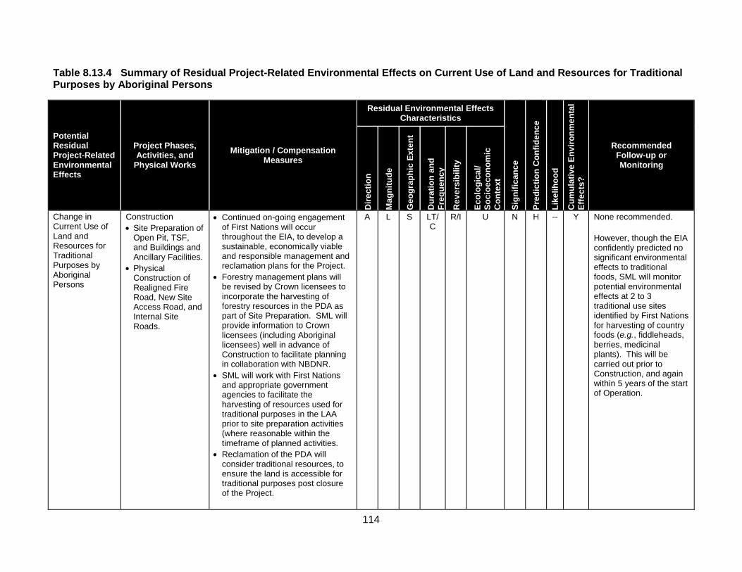
114
Table 8.13.4 Summary of Residual Project-Related Environmental Effects on Current Use of Land and Resources for Traditional Purposes by Aboriginal Persons
Potential Residual Project-Related Environmental Effects
Project Phases, Activities, and
Physical Works Mitigation / Compensation
Measures
Residual Environmental Effects Characteristics
Sign
ifica
nce
Pred
ictio
n C
onfid
ence
Like
lihoo
d
Cum
ulat
ive
Envi
ronm
enta
l Ef
fect
s?
Recommended Follow-up or Monitoring
Dire
ctio
n
Mag
nitu
de
Geo
grap
hic
Exte
nt
Dur
atio
n an
d Fr
eque
ncy
Rev
ersi
bilit
y
Ecol
ogic
al/
Soci
oeco
nom
ic
Con
text
Change in Current Use of Land and Resources for Traditional Purposes by Aboriginal Persons
Construction • Site Preparation of
Open Pit, TSF, and Buildings and Ancillary Facilities.
• Physical Construction of Realigned Fire Road, New Site Access Road, and Internal Site Roads.
• Continued on-going engagement of First Nations will occur throughout the EIA, to develop a sustainable, economically viable and responsible management and reclamation plans for the Project.
• Forestry management plans will be revised by Crown licensees to incorporate the harvesting of forestry resources in the PDA as part of Site Preparation. SML will provide information to Crown licensees (including Aboriginal licensees) well in advance of Construction to facilitate planning in collaboration with NBDNR.
• SML will work with First Nations and appropriate government agencies to facilitate the harvesting of resources used for traditional purposes in the LAA prior to site preparation activities (where reasonable within the timeframe of planned activities.
• Reclamation of the PDA will consider traditional resources, to ensure the land is accessible for traditional purposes post closure of the Project.
A L S LT/C
R/I U N H -- Y None recommended. However, though the EIA confidently predicted no significant environmental effects to traditional foods, SML will monitor potential environmental effects at 2 to 3 traditional use sites identified by First Nations for harvesting of country foods (e.g., fiddleheads, berries, medicinal plants). This will be carried out prior to Construction, and again within 5 years of the start of Operation.

115
Table 8.13.4 Summary of Residual Project-Related Environmental Effects on Current Use of Land and Resources for Traditional Purposes by Aboriginal Persons
Potential Residual Project-Related Environmental Effects
Project Phases, Activities, and
Physical Works Mitigation / Compensation
Measures
Residual Environmental Effects Characteristics
Sign
ifica
nce
Pred
ictio
n C
onfid
ence
Like
lihoo
d
Cum
ulat
ive
Envi
ronm
enta
l Ef
fect
s?
Recommended Follow-up or Monitoring
Dire
ctio
n
Mag
nitu
de
Geo
grap
hic
Exte
nt
Dur
atio
n an
d Fr
eque
ncy
Rev
ersi
bilit
y
Ecol
ogic
al/
Soci
oeco
nom
ic
Con
text
• SML will work to optimize training, employment, and business opportunities of the Project for Aboriginal people.
Operation
Decommissioning, Reclamation and Closure
Residual Environmental Effects for All Phases
N H -- Y

116
Table 8.13.4 Summary of Residual Project-Related Environmental Effects on Current Use of Land and Resources for Traditional Purposes by Aboriginal Persons
Potential Residual Project-Related Environmental Effects
Project Phases, Activities, and
Physical Works Mitigation / Compensation
Measures
Residual Environmental Effects Characteristics
Sign
ifica
nce
Pred
ictio
n C
onfid
ence
Like
lihoo
d
Cum
ulat
ive
Envi
ronm
enta
l Ef
fect
s?
Recommended Follow-up or Monitoring
Dire
ctio
n
Mag
nitu
de
Geo
grap
hic
Exte
nt
Dur
atio
n an
d Fr
eque
ncy
Rev
ersi
bilit
y
Ecol
ogic
al/
Soci
oeco
nom
ic
Con
text
KEY Direction P Positive. A Adverse. Magnitude L Low: No net loss of current use of land and
resources for traditional purposes by Aboriginal persons that is not mitigated.
M Moderate: A nominal loss, or a substantive loss that is mitigated, in the availability or access to land and/or resources currently used for traditional purposes by Aboriginal persons.
H High: An unmitigated, substantive and permanent loss in the availability or access to land and/or resources currently used for traditional purposes by Aboriginal persons.
Geographic Extent S Site-specific: Within the PDA. L Local: Within the LAA. R Regional: Within the RAA.
Duration ST Short-term: Occurs and lasts for
short periods (e.g., days/weeks).
MT Medium-term: Occurs and lasts for less than one year.
LT Long-term: Occurs during Construction and/or Operation and lasts for the life of Project.
P Permanent: Occurs during Construction and continues beyond completion of Decommissioning, Reclamation and Closure activities.
Frequency O Occurs once. S Occurs sporadically at irregular
intervals. R Occurs on a regular basis and
at regular intervals. C Continuous.
Reversibility R Reversible. I Irreversible. Ecological/Socioeconomic Context U Undisturbed: Area
relatively or not adversely affected by human activity.
D Developed: Area has been substantially previously disturbed by human development or human development is still present.
N/A Not Applicable. Significance S Significant. N Not Significant.
Prediction Confidence Confidence in the significance prediction, based on scientific information and statistical analysis, professional judgment and known effectiveness of mitigation: L Low level of confidence. M Moderate level of confidence. H High level of confidence. Likelihood If a significant environmental effect is predicted, the likelihood of that significant environmental effect occurring, based on professional judgment: L Low probability of occurrence. M Medium probability of occurrence. H High probability of occurrence. Cumulative Environmental Effects? Y Potential for environmental effect to interact with the
environmental effects of other past, present or foreseeable projects or activities in RAA.
N Environmental effect will not or is not likely to interact with the environmental effects of other past, present or foreseeable projects or activities in RAA.

117
Table 8.13.6 Potential Cumulative Environmental Effects to Current Use of Land and Resources for Traditional Purposes by Aboriginal Persons
Other Projects and Activities With Potential for Cumulative Environmental Effects
Potential Cumulative Environmental Effects Change in Current Use of Land and Resources for
Traditional Purposes by Aboriginal Persons Past or Present Projects or Activities That Have Been Carried Out Industrial Land Use (Past or Present) 0 Forestry and Agricultural Land Use (Past or Present) 0 Current Use of Land and Resources for Traditional Purposes by Aboriginal Persons (Past or Present) 0
Recreational Land Use (Past or Present) 0 Residential Land Use (Past or Present) 0 Potential Future Projects or Activities That Will Be Carried Out Industrial Land Use (Future) 0 Forestry and Agricultural Land Use (Future) 1 Current Use of Land and Resources for Traditional Purposes by Aboriginal Persons (Future) 0
Recreational Land Use (Future) 0 Planned Residential Development (Future) 0 Cumulative Environmental Effects Notes: Cumulative environmental effects were ranked as follows: 0 Project environmental effects do not act cumulatively with those of other projects or activities that have been or will be carried out. 1 Project environmental effects act cumulatively with those of other projects or activities that have been or will be carried out, but are
unlikely to result in significant cumulative environmental effects; or Project environmental effects act cumulatively with existing significant levels of cumulative environmental effects but the Project will not measurably contribute to these cumulative environmental effects on the VEC.
2 Project environmental effects act cumulatively with those of other projects or activities that have been or will be carried out, and may result in significant cumulative environmental effects; or Project environmental effects act cumulatively with existing significant levels of cumulative environmental effects and the Project may measurably contribute to adverse changes in the state of the VEC.
8.14 – Heritage Resources
This section’s narrative text describes the VEC concerned; summarizes how the effects assessment was carried out, and reports its conclusions. Section 8.14 presents this information under the following headings and opens with a summary statement. 8.14 Heritage Resources 8.14.1 Scope of Assessment 8.14.1.1 Rationale for Selection of Valued Environmental Component, Regulatory Context, and Issues Raised During Engagement 8.14.1.2 Selection of Environmental effect and Measurable Parameter 8.14.1.3 Temporal Boundaries 8.14.1.4 Spatial Boundaries 8.14.1.5 Administrative and Technical Boundaries 8.14.1.6 Residual Environmental Effects Significance Criteria 8.14.2 Existing Conditions 8.14.2.1 Background Research 8.14.2.2 Archaeological Survey 8.14.2.3 Shovel Testing Results To Date

118
8.14.3 Potential Project-VEC Interactions 8.14.3.1 Construction 8.14.3.2 Operation 8.14.3.3 Decommissioning, Reclamation and Closure 8.14.3.4 Summary 8.14.4 Assessment of Project-Related Environmental Effects 8.14.4.1 Potential Project Environmental Effects Mechanisms 8.14.4.2 Mitigation of Project Environmental Effects 8.14.4.3 Characterization of Residual project Environmental Effects 8.14.5 Assessment of Cumulative Environmental Effects 8.14.5.1 Past or Present Projects or Activities That Have Benn Carried Out 8.14.5.2 Future Projects or Activities That Will Be Carried Out 8.14.6 Determination of Significance 8.14.6.1 Residual Project Environmental Effects 8.14.6.2 Residual Cumulative Environmental Effects 8.14.7 Follow-up or Monitoring Summary Statement - Heritage Resources
The opening summary statement for Section 8.14 begins on Page 8-639. It explains that Heritage Resources are those resources, both human and natural, created by activities from the past that remain to inform present and future societies of that past. It further notes that Heritage Resources are relatively permanent, although highly tenuous, features of the environment. If they are present, their integrity is highly susceptible to construction and ground-disturbing activities. Heritage Resources were selected as a VEC in recognition of the interest of provincial and federal regulatory agencies who are responsible for the effective management of these resources, the general public as a whole, and First Nations that have an interest in the preservation and management of Heritage Resources related to their history and culture. For this VEC, Heritage Resources include consideration of historical, archaeological, architectural (built heritage), and palaeontological resources. The Report explains that any Project activity that includes surface or sub-surface ground disturbance has the potential for interaction with Heritage Resources, where they are present. Accordingly, Construction represents the Project phase with the greatest potential for interaction with Heritage Resources, as it is during this phase that the majority of the ground breaking and earth moving activities of surface soils would take place. From documentary research and field investigations carried out in support of the Project, the Report notes that there were no known Heritage Resources in the PDA, prior to the initiation of the shovel testing recommended within the PDA.
Based on information gathered by local First Nations, Aboriginal persons have used areas of central New Brunswick, including those near the Project, in carrying out their traditional activities. The discovery of archaeological resources in the PDA during shovel testing carried out in 2013 and 2014 provided further evidence that there has been Aboriginal use of this area in the distant past. The archaeological resources discovered within the PDA appear to date from between 6,500 and 7,500 years before present, based on the shape of the projectile points that have been recovered.

119
During the Historic Period, there was little settlement within and near the PDA, prior to the construction of a sawmill near Juniper on the South Branch Southwest Miramichi River in 1914. Similarly, there are no known architectural or palaeontological resources in or near the PDA.
During the field survey conducted in 2011, a number of areas with elevated potential to contain archaeological resources were identified, in particular along the shorelines of watercourses that have been identified by the Provincial archaeological potential map received from Archaeological Services in the New Brunswick Department of Tourism, Heritage and Culture.
The Report points out that sub-surface shovel testing carried out in 2013 and 2014 identified several hundred artifacts and recorded a number of archaeological sites, most of which were in the area of the Open Pit. Additionally, two artifacts were recovered from the area of the tailings storage facility (TSF). As agreed with NBDELG and as described in SML’s ESMS (Appendix D), SML intends to complete the archaeological test pitting in the Tailings Storage Facility (TSF) and Open Pit areas prior to commencement of construction. The rest of the test pitting, and any consequent archaeological site mitigation, would be completed according to a schedule to be agreed with Archaeological Services and NBDELG.
As a result of discovering archaeological resources in the PDA, a Heritage Mitigation Plan was developed to ensure that all work is conducted in accordance with the provincial Guidelines for Conducting Archaeological Assessments in New Brunswick, and the New Brunswick Heritage Conservation Act.
Given that all archaeological mitigation would be completed in accordance with the Heritage Mitigation Plan and applicable legislation and Guidelines, and these activities would be conducted in consultation with Archaeological Services, there would be no unauthorized disturbance to heritage resources that are not mitigated, and therefore the Project would not have a significant adverse environmental effect on Heritage Resources. Similarly, the Project would not, in combination with other past, present, or reasonably foreseeable future projects or activities, result in significant cumulative environmental effects.
A total of 4 tables and 3 illustrative figures are included in Section 8.14 and listed below: Tables Table 8.14.1 Measurable Parameter for Heritage Resources Table 8.14.2 Potential Project Environmental Effects to Heritage Resources Table 8.14.3 Summary of residual Project-Related Environmental Effects on Heritage Resources Table 8.14.4 Potential Cumulative Environmental Effects to Heritage Resources Figures
Figure 8.14.1 Project Development Area (PDA), and Local Assessment Area (LAA) for Heritage Resources Figure 8.14.2 Regional Assessment Area (RAA) for Heritage Resources Figure 8.14.3 Steps for the Evaluation of High, Medium and Low Archaeological Potential Areas

120
Table 8.14.3 is reproduced below and summarizes the Residual Project-Related Environmental Effects on Heritage Resources; mitigation or compensation measures proposed by the Study Team; characteristics of the residual effects, and recommended follow-up or monitoring.
Table 8.14.4 is reproduced below as well. It details and ranks Potential Cumulative Environmental Effects to Heritage Resources.

121
Table 8.14.3 Summary of Residual Project-Related Environmental Effects on Heritage Resources
Potential Residual Project-Related Environmental Effects
Project Phases, Activities, and Physical
Works Mitigation / Compensation Measures
Residual Environmental Effects Characteristics
Sign
ifica
nce
Pred
ictio
n C
onfid
ence
Like
lihoo
d
Cum
ulat
ive
Envi
ronm
enta
l Ef
fect
s?
Recommended Follow-up or Monitoring
Dire
ctio
n
Mag
nitu
de
Geo
grap
hic
Exte
nt
Dur
atio
n an
d Fr
eque
ncy
Rev
ersi
bilit
y
Ecol
ogic
al/
Soci
oeco
nom
ic C
onte
xt
Change in Heritage Resources
Construction: • Site Preparation of
Open Pit, TSF, and Buildings and Ancillary Facilities.
• Physical Construction and Installation of Project Facilities.
• Physical Construction Transmission Lines and Associated Infrastructure.
• Physical Construction of Realigned Fire Road, New Site Access Road, and Internal Site Roads.
• During the course of the archaeological survey conducted in 2011, several areas of elevated archaeological potential were identified that are recommended for shovel testing within the Project site (Stantec 2012j). It was noted that a redesign of the TSF would avoid two watercourses, and thus, greatly reduce the number of shovel test pits required for the TSF areas. The footprint of the TSF was modified, thus eliminating some of the elevated archaeological potential areas to be affected by Project activities, and reducing the number of required shovel test pits within the TSF. As the location of the open pit is fixed by the location of the ore body, it is not possible to make similar adjustments to the open pit.
• As mitigation for the Project, a systematic sub-surface test (“shovel testing”) program has been developed and submitted to Archaeological Services for review and approval. This shovel testing was undertaken in 2012, 2013 and 2014 by a permitted archaeologist. The shovel testing is following the provincial Guidelines (Archaeological Services 2012) and accepted professional standards and practices. As agreed with NBDELG and as described in SML’s ESMS (Appendix D), SML intends to complete the archaeological test pitting in the Tailings Storage Facility (TSF) and Open Pit areas prior to commencement of construction.
A H S P/O I U/D N H -- Y Monitoring of preliminary ground breaking construction activities in proximity to locations where archaeological resources were discovered..

122
Table 8.14.3 Summary of Residual Project-Related Environmental Effects on Heritage Resources
Potential Residual Project-Related Environmental Effects
Project Phases, Activities, and Physical
Works Mitigation / Compensation Measures
Residual Environmental Effects Characteristics
Sign
ifica
nce
Pred
ictio
n C
onfid
ence
Like
lihoo
d
Cum
ulat
ive
Envi
ronm
enta
l Ef
fect
s?
Recommended Follow-up or Monitoring
Dire
ctio
n
Mag
nitu
de
Geo
grap
hic
Exte
nt
Dur
atio
n an
d Fr
eque
ncy
Rev
ersi
bilit
y
Ecol
ogic
al/
Soci
oeco
nom
ic C
onte
xt
• Further to this, a Heritage Mitigation Plan has been developed (Stantec 2014b) to guide any and all archaeological investigation and excavation within the PDA. This Plan was reviewed by Archaeological Services and their comments implemented prior to finalizing the Plan. The Plan was also provided to First Nations for review and comment and those comments were also implemented prior to finalizing it.
• The archaeological resources discovered during the shovel testing will be mitigated in accordance with the Guidelines and the Heritage Conservation Act and in consultation with Archaeological Services and First Nations, as applicable, according to a schedule to be agreed with Archaeological Services and NBDELG.
• The archaeological survey of the 138 kV electrical transmission line will assist in the planning and placement of transmission line towers to avoid elevated areas of archaeological potential areas where possible. Due to the relatively small area of the transmission line towers and base, and the average 160 to 200 m span limit between transmission line towers, NB Power Transmission will attempt to move the location of these towers outside of any areas identified as having elevated potential for archaeological resources. Following the completion of the design of the new transmission line, any areas where towers

123
Table 8.14.3 Summary of Residual Project-Related Environmental Effects on Heritage Resources
Potential Residual Project-Related Environmental Effects
Project Phases, Activities, and Physical
Works Mitigation / Compensation Measures
Residual Environmental Effects Characteristics
Sign
ifica
nce
Pred
ictio
n C
onfid
ence
Like
lihoo
d
Cum
ulat
ive
Envi
ronm
enta
l Ef
fect
s?
Recommended Follow-up or Monitoring
Dire
ctio
n
Mag
nitu
de
Geo
grap
hic
Exte
nt
Dur
atio
n an
d Fr
eque
ncy
Rev
ersi
bilit
y
Ecol
ogic
al/
Soci
oeco
nom
ic C
onte
xt
cannot avoid areas of elevated archaeological potential will be subject to an archaeological survey that will determine detailed shovel testing recommendations that will be provided to Archaeological Services for approval prior to implementation.
• Any small areas of the PDA that may not have been previously assessed due to minor adjustments in the Project footprint will be assessed prior to initiating Construction, and any recommended mitigation (e.g., shovel testing) will be implemented. These areas likely have low archaeological potential as no additional watercourses or areas considered to hold elevated archaeological potential were identified on the archaeological potential map (Stantec 2012k).
• The specific recommendations of the number of shovel test pits are documented in the Archaeological Assessment Reports (Stantec 2012k; Stantec 2013g) and have been provided to Archaeological Services. The archaeological resources that have been identified during the shovel testing will require further mitigation (i.e., archaeological excavation) that will be implemented in consultation with Archaeological Services and in accordance with their most current Guidelines (Archaeological Services 2012). Local First Nations will be engaged as appropriate.
• The fish habitat offsetting/compensation requirements may result in the need for

124
Table 8.14.3 Summary of Residual Project-Related Environmental Effects on Heritage Resources
Potential Residual Project-Related Environmental Effects
Project Phases, Activities, and Physical
Works Mitigation / Compensation Measures
Residual Environmental Effects Characteristics
Sign
ifica
nce
Pred
ictio
n C
onfid
ence
Like
lihoo
d
Cum
ulat
ive
Envi
ronm
enta
l Ef
fect
s?
Recommended Follow-up or Monitoring
Dire
ctio
n
Mag
nitu
de
Geo
grap
hic
Exte
nt
Dur
atio
n an
d Fr
eque
ncy
Rev
ersi
bilit
y
Ecol
ogic
al/
Soci
oeco
nom
ic C
onte
xt
ground disturbance associated with the development of the offset measure. Prior to any construction activities, a detailed archaeological survey will be completed in order to determine if a shovel testing strategy as warranted. Any recommendations for shovel testing will be reviewed and approved by Archaeological Services and completed prior to any proposed ground breaking activities associated with fish habitat offsetting/compensation activities.
• A heritage resources response procedure will be in place and will be followed during Project-related construction activities as a part of the overall ESMS. This procedure will document that in the event of the discovery of a potential archaeological or palaeontological site, all work in this area would immediately be temporarily suspended and a sufficient buffer would be established around the find until it can be fully investigated. If it is confirmed to be a heritage resource, appropriate mitigation will be developed and implemented in consultation with Archaeological Services, the NBM, and First Nations, as appropriate. The heritage resources response procedure will include procedures to be followed in the event of the discovery of archaeological resources, palaeontological resources, and unidentified bone material.
Operation

125
Table 8.14.3 Summary of Residual Project-Related Environmental Effects on Heritage Resources
Potential Residual Project-Related Environmental Effects
Project Phases, Activities, and Physical
Works Mitigation / Compensation Measures
Residual Environmental Effects Characteristics
Sign
ifica
nce
Pred
ictio
n C
onfid
ence
Like
lihoo
d
Cum
ulat
ive
Envi
ronm
enta
l Ef
fect
s?
Recommended Follow-up or Monitoring
Dire
ctio
n
Mag
nitu
de
Geo
grap
hic
Exte
nt
Dur
atio
n an
d Fr
eque
ncy
Rev
ersi
bilit
y
Ecol
ogic
al/
Soci
oeco
nom
ic C
onte
xt
Decommissioning, Reclamation and Closure
Residual Environmental Effects for all Phases
N H -- Y
KEY Direction P Positive. A Adverse. Magnitude 1 = Low: Minor impairments to heritage
resources appreciation or affects to non-significant Historic period heritage feature (e.g., stone fence line, field stone pile; loss of individual artifact).
2 = Medium: Loss of heritage resources not of major importance or pre-disturbed heritage site, artifacts present, however, no or little chance of intact features.
3 = High: A permanent Project-related disturbance to, or destruction of, all or part of a heritage resource (i.e., archaeological, architectural or palaeontological resources) considered by the provincial heritage regulators to be of major importance due to factors such as rarity, undisturbed condition, spiritual importance, or research importance, but that can be mitigated or compensated to the extent that the environmental effects are not significant.
Geographic Extent S Site-specific: Within the PDA. L Local: Within the LAA. R Regional: Within the RAA. Duration ST Short-term: Occurs and lasts for
short periods (e.g., days/weeks). MT Medium-term: Occurs and lasts
for extended periods of time (e.g., years).
LT Long-term: Occurs during Construction and/or Operation and lasts for the life of Project.
P Permanent: Occurs during Construction and Operation and beyond.
Frequency O Occurs once. S Occurs sporadically at irregular
intervals. R Occurs on a regular basis and at
regular intervals. C Continuous.
Reversibility R Reversible. I Irreversible. Ecological/Socioeconomic Context U Undisturbed: Area relatively or
not adversely affected by human activity.
D Developed: Area has been substantially previously disturbed by human development or human development is still present.
N/A Not Applicable. Significance S Significant. N Not Significant.
Prediction Confidence Confidence in the significance prediction, based on scientific information and statistical analysis, professional judgment and known effectiveness of mitigation: L Low level of confidence. M Moderate level of confidence. H High level of confidence. Likelihood If a significant environmental effect is predicted, the likelihood of that significant environmental effect occurring is determined, based on professional judgment: L Low probability of occurrence. M Medium probability of occurrence. H High probability of occurrence. Cumulative Environmental Effects? Y Potential for environmental effect to interact with the
environmental effects of other past, present or foreseeable future projects or activities in RAA.
N Environmental effect will not or is not likely to interact with the environmental effects of other past, present or foreseeable future projects or activities in RAA.

126
Table 8.14.4 Potential Cumulative Environmental Effects to Heritage Resources
Other Projects or Activities With Potential for Cumulative Environmental Effects
Potential Cumulative Environmental Effects Change in Heritage Resources
Past or Present Projects or Activities That Have Been Carried Out Industrial Land Use (Past or Present) 1 Forestry and Agricultural Land Use (Past or Present) 1 Current Use of Land and Resources for Traditional Purposes by Aboriginal Persons (Past or Present) 0
Recreational Land Use (Past or Present) 0 Residential Land Use (Past or Present) 1 Potential Future Projects or Activities That Will Be Carried Out Industrial Land Use (Future) 0 Forestry and Agricultural Land Use (Future) 1 Current Use of Land and Resources for Traditional Purposes by Aboriginal Persons (Future) 0
Recreational Land Use (Future) 0 Planned Residential Development (Future) 0 Cumulative Environmental Effects Notes: Cumulative environmental effects were ranked as follows: 0 Project environmental effects do not act cumulatively with those of other projects or activities that have been or will be carried out. 1 Project environmental effects act cumulatively with those of other projects or activities that have been or will be carried out, but are
unlikely to result in significant cumulative environmental effects; or Project environmental effects act cumulatively with existing significant levels of cumulative environmental effects but will not measurably change the state of the VEC.
2 Project environmental effects act cumulatively with those of other projects or activities that have been or will be carried out, and may result in significant cumulative environmental effects; or Project environmental effects act cumulatively with existing significant levels of cumulative environmental effects and may measurably change the state of the VEC.
8.15 – Transportation This section’s narrative text describes the VEC concerned; summarizes how the effects assessment was carried out, and reports its conclusions. Section 8.15 presents this information under the following headings. 8.15 Transportation 8.15.1 Scope of Assessment 8.15.1.1 Rationale for Selection of Valued Environmental Component, Regulatory Context, and
Issues Raised During Engagement 8.15.1.2 Selection of Environmental Effect and Measurable Parameters 8.15.1.3 Temporal Boundaries 8.15.1.4 Spatial Boundaries 8.15.1.5 Administrative and Technical Boundaries 8.15.1.6 Residual Environmental Effects Significance Criteria 8.15.2 Existing Conditions 8.15.2.1 Primary Site Access (PSA) Route and Secondary Site Access (SSA) Route 8.15.2.2 Existing Road Transportation Network 8.15.2.3 Existing Level of Service 8.15.2.4 Existing Traffic Safety 8.15.2.5 Existing Road Network Infrastructure Condition 8.15.3 Potential Project-VEC Interactions 8.15.4 Assessment of Project-Related Environmental Effects 8.15.4.1 Potential Project Environmental Effect Mechanisms 8.15.4.2 Mitigation of Project Environmental Effects

127
8.15.4.3 Characterization of Residual Project Environmental Effects 8.15.4.3.1 Road Infrastructure 8.15.4.3.2 Traffic Level of Service 8.15.4.3.3 Summary 8.15.5 Assessment of Cumulative Environmental Effects 8.15.6 Determination of Significance 8.15.6.1 Residual Project Environmental Effects 8.15.6.2 Residual Cumulative Environmental Effects 8.15.7 Follow-up or Monitoring Summary Statement - Transportation
The opening summary statement for Section 8.15 notes that Transportation, including both road and rail transportation modes, and the infrastructure networks that support them, are important to the public in the area surrounding the Project for access and mobility. The Report points out that road and rail transportation are also important for the safe transportation of workers and supplies to and from the Project. It states that Transportation was identified by regulatory agencies and the public as a VEC. The expected contribution of the Project to existing traffic levels in the Project area and the responsibility for maintenance of the transportation network that could be degraded as a result of the Project were a particular concern. Though existing rail infrastructure and port facilities would be used for the Project, these facilities would remain unchanged from their current state, and no new rail or port infrastructure is required or planned to facilitate their use by the Project. The Report points out that vehicles would carry personnel, materials, supplies and products to/from the Project site during all phases of the Project, which would result in increased traffic volumes on existing public and forest resource roads leading to and from the Project site. It notes that increased traffic volumes have the potential to cause traffic delays by reducing the level of service (LOS), and/or damaging road infrastructure, and increase the potential for accidents or collisions.
The Report states that Project-related traffic would use the existing provincial highway transportation network and existing forest resource roads to access the Project site. It adds that these roads are under-used and more than able to accommodate the limited increased traffic that would arise from the Project, with some maintenance and refurbishment as necessary.
The likelihood of over-capacity on, or sustained damage to, the existing road transportation network arising from the Project would be mitigated by the use of a primary truck route that uses the provincial highway (maximum allowable weight limits, all truck configurations permitted) as well as forest resource roads designated for heavy trucking.
Bussing of personnel from off-site parking lots would also reduce the volume of traffic on the site access routes during Construction, and limit the number of vehicles travelling to and from the Project site each day.

128
With the proposed mitigation described above, and with SML consultation and agreements with the Crown Timber Licence Holders, and NBDNR regarding the refurbishment and maintenance required on the forest road network, the Report states that the environmental effects of the Project on Transportation would be not significant.
A total of 17 tables and 2 illustrative figures are included in Section 8.15 and listed below: Tables Table 8.15.1 Measurable Parameters for Transportation Table 8.15.2 Highway Designations in New Brunswick Table 8.15.3 Level of Service (LOS) Criteria Table 8.15.4 Road Network Infrastructure Condition Geometric Criteria Table 8.15.5 Existing Level of Service (LOS) for Selected Routes within the LAA Table 8.15.6 Existing Levels of Service of Key Intersections Table 8.15.7 Existing Collision Rates Along provincial Highway Routes (2006-2010) Table 8.15.8 Geometric Characteristics of Roads within the LAA Table 8.15.9 Potential Project Environmental Effects to Transportation Table 8.15.10 Summary of Residual Project-Related Environmental Effects on Transportation Table 8.15.11 Distribution of Traffic Volumes to Highway Segments – Construction Phase Table 8.15.12 Distribution of Traffic Volumes to Highway Segments – Operation Phase Table 8.15.13 Level of Service – Existing Conditions and Construction Phase Table 8.15.14 Level of Service at Key Intersections – Existing Conditions and Construction Phase Table 8.15.15 Level of Service – Existing Conditions and Operation Phase Table 8.15.16 Level of Service at Key Intersections – Existing Conditions and Operation Phase Table 8.15.17 Potential Cumulative Environmental Effects to Transportation
Figures
Figure 8.15.1 Local Assessment Area (LAA) and Regional Assessment Area (RAA) for Transportation Figure 8.15.2 Primary Site Assessment (PSA) Route and Secondary Site Access (SSA) Route
Table 8.15.10 is reproduced below and summarizes the Residual Project-Related Environmental Effects on Transportation; mitigation or compensation measures proposed by the Study Team; characteristics of the residual effects, and recommended follow-up or monitoring.
Table 8.15.17 is reproduced below as well. It details and ranks Potential Cumulative Environmental Effects to Transportation.

129
Table 8.15.10 Summary of Residual Project-Related Environmental Effects on Transportation
Potential Residual Project-Related Environmental Effects
Project Phases, Activities, and
Physical Works Mitigation / Compensation Measures
Residual Environmental Effects Characteristics
Sign
ifica
nce
Pred
ictio
n C
onfid
ence
Like
lihoo
d
Cum
ulat
ive
Envi
ronm
enta
l Ef
fect
s?
Recommended Follow-up or Monitoring
Dire
ctio
n
Mag
nitu
de
Geo
grap
hic
Exte
nt
Dur
atio
n an
d Fr
eque
ncy
Rev
ersi
bilit
y
Ecol
ogic
al/
Soci
oeco
nom
ic
Con
text
Change in Transportation
Construction • Transportation.
Mitigation to be implemented in Construction and Operation is as follows. • During Construction, bussing of
personnel to/from the Project location from off-site parking lots in Nackawic and Napadogan, and potentially from other towns.
• The designation of principal truck routes to the Project site to limit truck traffic to PSA and SSA routes during all phases.
• Design of the realignment of the Fire Road will be done in consultation with and approved by NBDNR and in agreement with the Crown Timber Licence Holders.
• Adherence to current design standards and best-practices for forest road construction, for the realignment of the Fire Road and refurbishment of the forest resource roads along the PSA and SSA routes as required to accommodate two-way Project traffic on the realigned section of Fire Road.
• In consultation with NBDNR and the Crown Timber Licence Holders, maintenance of the roadway and roadside warning signs to reduce traffic safety risks along the forest
A M L MT/S
R D N H - Y None recommended.

130
Table 8.15.10 Summary of Residual Project-Related Environmental Effects on Transportation
Potential Residual Project-Related Environmental Effects
Project Phases, Activities, and
Physical Works Mitigation / Compensation Measures
Residual Environmental Effects Characteristics
Sign
ifica
nce
Pred
ictio
n C
onfid
ence
Like
lihoo
d
Cum
ulat
ive
Envi
ronm
enta
l Ef
fect
s?
Recommended Follow-up or Monitoring
Dire
ctio
n
Mag
nitu
de
Geo
grap
hic
Exte
nt
Dur
atio
n an
d Fr
eque
ncy
Rev
ersi
bilit
y
Ecol
ogic
al/
Soci
oeco
nom
ic
Con
text
Operation • Transportation.
roads that are part of the PSA and SSA routes during all phases.
• In consultation with NBDTI, NBDNR and the Crown Timber Licence Holders, the clearing of bushes along roadsides to improve sight distance at the approaches of the intersections of the PSA and SSA routes at provincial highways during Operation.
• Compliance with the existing forest roads best practices that require use of CB radio systems (in SML-controlled vehicles like heavy trucks and buses) for communicating the location of heavy or vehicles among drivers will reduce traffic safety risks along the PSA and SSA routes during all phases.
• Traffic Plan will be developed to guide Project employees and delivery vehicles that specifically identifies roadway hazards along the PSA and SSA routes. The Traffic Plan will include communications and best-practices training and a monitoring and reporting program aimed at reducing traffic safety risks along the PSA and SSA routes for the Operation phase.
A L L MT/R
R D N H Y

131
Table 8.15.10 Summary of Residual Project-Related Environmental Effects on Transportation
Potential Residual Project-Related Environmental Effects
Project Phases, Activities, and
Physical Works Mitigation / Compensation Measures
Residual Environmental Effects Characteristics
Sign
ifica
nce
Pred
ictio
n C
onfid
ence
Like
lihoo
d
Cum
ulat
ive
Envi
ronm
enta
l Ef
fect
s?
Recommended Follow-up or Monitoring
Dire
ctio
n
Mag
nitu
de
Geo
grap
hic
Exte
nt
Dur
atio
n an
d Fr
eque
ncy
Rev
ersi
bilit
y
Ecol
ogic
al/
Soci
oeco
nom
ic
Con
text
Decommissioning, Reclamation and Closure
Residual Environmental Effects for all Phases
N H - Y
KEY Direction P Positive. A Adverse. Magnitude L Low: No damage to infrastructure, no
change in overall LOS, or no change in accident rates.
M Moderate: Slight increase or minor localized and/or repairable damage to road infrastructure, or unmitigated change in overall LOS by one category, but not below LOS D; or increase in accident rates that would be of concern to NBDTI, NBDNR, or the Crown Licence Holders, requiring mitigation.
H High: Substantial damage to road infrastructure; substantial unmitigated change in overall LOS by more than one category or to lower than LOS D; or increase in accident rates that would be of concern to NBDTI, NBDNR, or the Crown Licence Holders, requiring mitigation.
Geographic Extent S Site-specific: Within the PDA. L Local: Within the LAA. R Regional: Within the RAA. Duration ST Short-term: Occurs and lasts for short
periods (e.g., days/weeks). MT Medium-term: Occurs and lasts for
extended periods of time (e.g., years). LT Long-term: Occurs during Construction
and/or Operation and lasts for the life of Project.
P Permanent: Occurs during Construction and Operation and beyond.
Frequency O Occurs once. S Occurs sporadically at irregular
intervals. R Occurs on a regular basis and at
regular intervals. C Continuous.
Reversibility R Reversible. I Irreversible. Ecological/Socioeconomic Context U Undisturbed: Area
relatively or not adversely affected by human activity.
D Developed: Area has been substantially previously disturbed by human development or human development is still present.
N/A Not Applicable. Significance S Significant. N Not Significant.
Prediction Confidence Confidence in the significance prediction, based on scientific information and statistical analysis, professional judgment and known effectiveness of mitigation: L Low level of confidence. M Moderate level of confidence. H High level of confidence. Likelihood If a significant environmental effect is predicted, the likelihood of that significant environmental effect occurring is determined, based on professional judgment: L Low probability of occurrence. M Medium probability of occurrence. H High probability of occurrence. Cumulative Environmental Effects? Y Potential for environmental effect to interact with the
environmental effects of other past, present or foreseeable future projects or activities in RAA.
N Environmental effect will not or is not likely to interact with the environmental effects of other past, present or foreseeable future projects or activities in RAA.

132
Table 8.15.17 Potential Cumulative Environmental Effects to Transportation
Other Projects or Activities With Potential for Cumulative Environmental Effects
Potential Cumulative Environmental Effects Change in Transportation
Past or Present Projects or Activities That Have Been Carried Out Industrial Land Use (Past or Present) 1 Forestry and Agricultural Land Use (Past or Present) 1 Current Use of Land and Resources for Traditional Purposes by Aboriginal Persons (Past or Present) 0
Recreational Land Use (Past or Present) 1 Residential Land Use (Past or Present) 1 Potential Future Projects or Activities That Will Be Carried Out Industrial Land Use (Future) 1 Forestry and Agricultural Land Use (Future) 1 Current Use of Land and Resources for Traditional Purposes by Aboriginal Persons (Future) 0
Recreational Land Use (Future) 1 Planned Residential Development (Future) 1 Cumulative Environmental Effects Notes: Cumulative environmental effects were ranked as follows: 0 Project environmental effects do not act cumulatively with those of other projects or activities that have been or will be carried out. 1 Project environmental effects act cumulatively with those of other projects or activities that have been or will be carried out, but are
unlikely to result in significant cumulative environmental effects; or Project environmental effects act cumulatively with existing significant levels of cumulative environmental effects but the Project will not measurably contribute to these cumulative environmental effects on the VEC.
2 Project environmental effects act cumulatively with those of other projects or activities that have been or will be carried out, and may result in significant cumulative environmental effects; or Project environmental effects act cumulatively with existing significant levels of cumulative environmental effects and the Project may measurably contribute to adverse changes in the state of the VEC.
8.16 – Effects of the Environment on the Project This section’s narrative text describes the issue concerned; summarizes how the effects assessment was carried out, and reports its conclusions. Section 8.16 presents this information under the following headings and opens with a summary statement. 8.16 Effects of the Environment of the Project 8.16.1 Environmental Attributes 8.16.2 Selection of Effects 8.16.3 Environmental Assessment Boundaries 8.16.3.1 Spatial Boundaries 8.16.3.2 Temporal Boundaries 8.16.3.3 Administrative and Technical Boundaries 8.16.4 Residual Effects Rating Criteria 8.16.5 Existing Conditions 8.16.5.1 Climatological Background (1971 to 2000) 8.16.5.2 Seismic Activity 8.16.5.3 Forest Fires 8.16.6 Effects Assessment 8.16.6.1 Effects of Climate on the Project 8.16.6.2 Effects of Seismic Activity on the Project 8.16.6.3 Effects of a Forest Fire on the Project 8.16.7 Determination of Significance
133
8.16.8 Follow-up or Monitoring Summary Statement – Effects of the Environment on the Project
The opening summary statement on Section 8.16 begins on Page 8-729. It explains that Effects of the Environment on the Project are associated with risks of natural hazards and influences of nature on the Project. Typically, potential effects of the environment on any project are a function of project or infrastructure design in the context of its receiving environment, and ultimately how the project is affected by nature. The Report states that these effects may arise from physical conditions, land forms, and site characteristics or other attributes of the environment which may act on the project such that the project components, schedule, and/or costs could be substantively and adversely changed. In general, environmental conditions that can affect Construction of the Project, infrastructure, or operational performance would be communicated to the Design Team and addressed through engineering design and industry standards. The Report notes that good engineering design involves the consideration of environmental effects and loadings or stresses (from the environment) on a project. It states that the planning and engineering design for this Project would be no exception.
As a matter of generally accepted engineering practice, the Report explains that responsible and viable engineering designs tend to consistently overestimate and account for possible forces of the environment, and thus inherently incorporate several factors of safety to ensure that a project is designed to be safe and reliable throughout its lifetime.
For the Project, long-term environmental management and Project longevity are inherent considerations in the best management practices of the design and associated Project risk management. Equipment and materials that are able to withstand severe weather and other influences would be used. Environmental stressors, such as those that could arise as a result of climate change, severe weather, or other factors (e.g., seismic event, forest fire), would more than adequately be addressed by good engineering design, materials selection, best practices, and engineering foresight.
The Report states that, while there is potential for natural forces to affect the Project, it is not likely to have a substantive effect on Construction or Operation due to planned mitigation and design. Mitigation strategies for minimizing the likelihood of a significant adverse effect of the environment on the Project are inherent in: the planning process conducted; the application of engineering design codes and standards; construction practices, and monitoring.
As such, and in consideration of the responsible design and best management practices that would be applied throughout the design, Construction, Operation, and Decommissioning, Reclamation and Closure phases of the Project, the Report states that the Effects of the Environment on the Project during all phases of the Project have been rated not significant.
A total of 1 table and 2 illustrative figures are included in Section 8.16 and listed below:

134
Tables Table 8.16.1 Projected Mean Annual Maximum and Minimum Temperature Change, and
Precipitation Percent Change for both SDSM and CGCM1 Model Results Figures
Figure 8.16.1 Predominant Monthly Wind Direction, Monthly Mean, Maximum Hourly and Maximum Gust Wind Speeds (1971 to 2000) at Fredericton, New Brunswick Figure 8.16.2 Average Fire Weather Index for the Month of July (1981-2010) 8.17 – Accidents, Malfunctions and Unplanned Events This section’s narrative text describes the issue concerned; summarizes how the effects assessment was carried out, and reports its conclusions. Section 8.16 presents this information under the following headings. 8.17 Accidents, Malfunctions and Unplanned Events 8.17.1 Methodology 8.17.2 Selection of Accidents, Malfunctions and Unplanned Events 8.17.2.1 Non-Credible Accidents, Malfunctions and Unplanned Events 8.17.2.1.1 Loss of Containment from Tailings Storage Facility (TSF) 8.17.2.1.2 Failure of a Water Management Pond 8.17.2.1.3 Uncontrolled Explosion 8.17.2.2 Credible Accidents, Malfunctions and Unplanned Events 8.17.3 Environmental Effects Assessment 8.17.3.1 Erosion and Sediment Control Failure 8.17.3.1.1 Description of Scenario 8.17.3.1.2 Environmental Effects Assessment 8.17.3.1.2.1 Aquatic Environment 8.17.3.1.3 Determination of Significance 8.17.3.2 Pipeline Leak 8.17.3.2.1 Descripton of Scenarios 8.17.3.2.2 Environmental Effects Assessment 8.17.3.2.3 Determination of Significance 8.17.3.3 On-site Hazardous Material Spill 8.17.3.3.1 Description of Scenarios 8.17.3.3.2 Environmental Effects Assessment 8.17.3.3.2.1 Water Resources 8.17.3.3.3 Determination of Significance 8.17.3.4 Release of Off-Specification Effluent from Water Treatment Plan 8.17.3.4.1 Description of Scenario 8.17.3.4.2 Environmental Effects Assessment 8.17.3.4.2.1 Water Resources 8.17.3.4.2.2 Aquatic Environment 8.17.3.4.3 Determination of Significance 8.17.3.5 Failure of Water Management Pond Pump 8.17.3.5.1 Description of Scenario 8.17.3.5.2 Environmental Effects Assessment 8.17.3.5.2.1 Water Resources 8.17.3.5.2.2 Aquatic Environment 8.17.3.5.3 Determination of Significance

135
8.17.3.6 Off-Site Trucking Accident 8.17.3.6.1 Description of Scenarios 8.17.3.6.2 Environmental Effects Assessment 8.17.3.6.2.1 Water Resources 8.17.3.6.2.2 Aquatic Environment 8.17.3.6.2.3 Wetland Environment 8.17.3.6.3 Determination of Significance 8.17.3.7 Vehicle Collision 8.17.3.7.1 Description of Scenarios 8.17.3.7.2 Environmental Effects Assessment 8.17.3.7.2.1 Terrestrial Environment 8.17.3.7.2.2 Public Health and Safety, and Transportation 8.17.3.7.3 Determination of Significance 8.17.3.8 Fire 8.17.3.8.1 Description of Scenario 8.17.3.8.2 Environmental Effects Assessment 8.17.3.8.2.1 Terrestrial Environment 8.17.3.8.2.2 Vegetated Environment 8.17.3.8.2.3 Public Health and Safety 8.17.3.8.3 Determination of Significance 8.17.4 Overall Summary and Determination of Significance Summary Statement – Accidents, Malfunctions and Unplanned Events
The opening summary statement on Section 8.17 begins on Page 8-749. It explains that Accidents, Malfunctions and Unplanned Events refers to events or upset conditions that are not part of any activity or normal operation of the Project, as has been planned by SML. The Report notes that, even with the best planning and the implementation of preventative measures, the potential exists for accidents, malfunctions or unplanned events to occur during any Project phase, and if they occur, for adverse environmental effects to result, if these events are not addressed or responded to in an environmentally appropriate manner. It states that many accidents, malfunctions and unplanned events are, however, preventable and can be readily addressed or prevented by good planning, design, emergency response planning, and mitigation. By identifying and assessing the potential for these events to occur, SML can also identify and put in place prevention and response procedures to minimize or eliminate the potential for significant adverse environmental effects, should an accidental event occur. As was described in Chapters 2 and 3, the Report states that the Project is being designed, and would be constructed and operated, according to best practice for health, safety, and environmental protection to minimize the potential environmental effects that could result from the Project, as well as those that could result from accidents, malfunctions or unplanned events.
Prevention and mitigation would be accomplished by the following general principles:
• use best management practices and technology for carrying out the Project while controlling permitted/allowable releases to the environment and consequent environmental effects;
136
• incorporate safety and reliability by design, and application of principles and practices of process and mine safety management;
• develop and apply procedures and training aimed at safe operation of the facilities that prevent or avoid the potential upsets that might lead to accidents, malfunctions or unplanned events; and
• implement effective emergency preparedness and response.
The Report notes that Chapter 3 provided a discussion of the features of the Project that would accomplish the safe, reliable, and environmentally responsible implementation of the Project, as well as how it would be carefully constructed, operated, and ultimately decommissioned in a manner that minimizes the potential for Accidents, Malfunctions and Unplanned Events to occur.
It states that the Project design, mitigation, and response procedures implemented as part of the planning stage of the Project, and as would be adapted throughout the Project life, are intended to minimize the potential for accidents, malfunctions and unplanned events to occur. With their development and implementation, the potential for such events to occur would be greatly reduced.
In the unlikely event of an accident, malfunction or unplanned event, emergency response plans and corrective action procedures would be implemented to minimize the resulting environmental effects. The Project would have safety measures built in to mitigate or manage potential upsets, should they occur. Employees would be trained in operational procedures and environmental emergency response procedures, including safety measures to prevent and respond to Accidents, Malfunctions and Unplanned Events.
A total of 11 tables are included in Section 8.17 and listed below:
Tables Table 8.17.1 Credible Accidents, Malfunctions and Unplanned Events and Scenarios Table 8.17.2 Potential Interactions between VECs and Erosion and Sediment Control Failure Table 8.17.3 Potential Interactions between VECs and Pipeline Leak Table 8.17.4 Potential Interactions between VECs and On-Site Hazardous Material Spill Table 8.17.5 Potential Interactions between VECs and Release of Off-Specification Effluent from Water Treamtent Plant Table 8.17.6 Potential Interactions between VECs and Failure of Water Management Pond Pump Table 8.17.7 Potnetial Interactions between VECs and an Off-Site Trucking Accident Table 8.17.8 Potential Interactions between VECs and a Vehicle Collision Table 8.17.9 Existing Collision Rates along Provincial Highway Routes (2006-2010) Table 8.17.10 Potential Interactions between VECs and a Fire Table 8.17.11 Summary of Residual Environmental Effects for Accidents, Malfunctions and Unplanned Events
Table 8.17.11 is reproduced below and summarizes the residual environmental effects predicted for each VEC for each accident scenario. The Report notes that, for most scenarios, it was assumed that these could occur during any Project phase. Overall, the environmental effects of most accidents, malfunctions and unplanned events during all phases of the Project were rated not significant, with a few exceptions where environmental effects were rated significant, but are unlikely to occur.

137
Table 8.17.11 Summary of Residual Environmental Effects for Accidents, Malfunctions and Unplanned Events
VEC
Accident, Malfunction or Unplanned Event
Erosion and Sediment
Control Failure Pipeline Leak
On-Site Hazardous
Materials Spill
Release of Off-Specification
Effluent from Water Treatment
Plant
Failure of Water
Management Pond Pump
Off-Site Trucking Accident
Vehicle Collision Fire
Atmospheric Environment NS NS NS NS NS NS NS NS Acoustic Environment NS NS NS NS NS NS NS NS Water Resources NS NS NS NS NS Ns NS NS Aquatic Environment NS NS NS NS NS NS NS NS
Terrestrial Environment NS NS NS NS NS NS S/U (SAR only) NS (all others)
S/U (SAR only) NS (all others)
Vegetated Environment NS NS NS NS NS NS NS NS Wetland Environment NS NS NS NS NS NS NS NS Public Health and Safety NS NS NS NS NS NS S/U S/U Labour and Economy NS NS NS NS NS NS NS NS Community Services and Infrastructure NS NS NS NS NS NS NS NS
Land and Resource Use NS NS NS NS NS NS NS NS Current Use of Land and Resources for Traditional Purposes by Aboriginal Persons
NS NS NS NS NS NS NS NS
Heritage Resources NS NS NS NS NS NS NS NS Transportation NS NS NS NS NS NS NS NS Notes: NS – Not Significant Residual Environmental Effect Predicted. S – Significant Residual Environmental Effect Predicted. U – Residual Environmental Effect is Unlikely to Occur.

138
Chapter 9 – Follow-Up and Monitoring Program This chapter describes the Follow-up and Monitoring Program proposed and recommended for the valued environmental components (VECs) presented in the Report. Chapter 9 presents this information under the following headings and opens with an overview statement. 9.1 Overview 9.2 Elements of Follow-Up and Monitoring Program 9.3 Follow-Up and Monitoring Program Implementation 9.3.1 Responsibilities 9.3.2 Follow-Up and Monitoring Methods 9.3.2.1 Collection of Baseline Data 9.3.2.2 Environmental Effects Assessment Predictions 9.3.2.3 Identification of Parameters for Follow-Up or Monitoring 9.3.2.4 Determination of Frequency of Follow-Up or Monitoring 9.3.2.5 Reproducibility of Follow-Up or Monitoring Results 9.3.2.6 Quality Assurance/Quality Control Procedures 9.3.3 Community/Stakeholder/Aboriginal Involvement 9.3.4 Adaptive Management 9.3.5 Documentation and Reporting 9.4 Proposed Follow-up and/or Monitoring Measures 9.4.1 VECs with No Follow-up or Monitoring 9.4.2 VECs with Follow-up Monitoring 9.4.3 Follow-up 9.4.3.1 Acoustic Environment 9.4.3.2 Aquatic Environment 9.4.3.3 Water Resources 9.4.3.4 Terrestrial Environment 9.4.3.5 Vegetated Environment 9.4.3.6 Wetland Environment 9.4.3.7 Public Health and Safety 9.4.3.8 Current Use of Land and Resources for Traditional Purposes by Aboriginal Persons 9.4.3.9 Heritage Resources 9.4.4 Monitoring 9.4.4.1 Atmospheric Environment 9.4.4.2 Acoustic Environment 9.4.4.3 Aquatic Environment 9.4.4.4 Water Resources 9.4.4.5 Terrestrial Environment 9.4.4.6 Wetland Environment 9.4.4.7 Current Use of Land and Resources for Traditional Purposes by Aboriginal Persons 9.4.4.8 Heritage Resources 9.4.4.9 Accidents, Malfunctions or Unplanned Events 9.4.5 Follow-up or Monitoring during Decommissioning, Reclamation and Closure Overview Statement – Follow-Up and Monitoring
The Report begins its overview statement for this Chapter on Page 9-1. It explains that Follow-Up and Monitoring is an integral part of SML’s Environmental and Social Management System (ESMS), aimed at verifying environmental effects predictions and the effectiveness of mitigation.

139
It would provide SML with means of ensuring compliance with applicable laws and regulations, and targets and objectives for continuous improvement it has established for itself within its ESMS. The Report also states that this program would also provide SML the means for identifying undesirable change and a basis for adaptive management as required. It notes that the Follow-up and Monitoring Program has been proposed and recommended for consideration by the governments of New Brunswick and Canada in determining the follow-up and/or monitoring activities associated with approvals, permits and authorizations required before the Project could proceed. The Report points out that, throughout this chapter, “follow-up” is defined, as in CEAA, as “a program for (a) verifying the accuracy of the environmental assessment of a project, and (b) determining the effectiveness of any measures taken to mitigate the adverse environmental effects of the project”. It notes that, although additional monitoring or other requirements might apply to the Project to verify compliance with environmental legislation (e.g., compliance monitoring) or to achieve other goals, such requirements are not considered to be part of a formal follow-up program as defined in CEAA. For clarity, the Report states, Chapter 9 distinguishes between measures or recommendations that are defined as “follow-up” (i.e., to verify the environmental effects predictions and/or the effectiveness of mitigation) as distinct from those that are related to “monitoring” (i.e., for demonstrating compliance or for any other purpose outside of the meaning of “follow-up” as defined by CEAA It further explains that Follow-up measures have been proposed where the EIA Report has identified a need to confirm the predictions of the EIA (e.g., when the Study Team’s confidence in the significance prediction is low or moderate), or where the effectiveness of mitigation needs to be verified (e.g., for non-standard mitigation or where new technology is being proposed).
The nature of and need for follow-up is also informed by the sensitivity of the VEC to potential Project-related environmental effects that may be greater than predicted or where mitigation may be found to be ineffective. Conversely, monitoring is generally carried out to measure compliance with the requirements of environmental laws or regulations, or the conditions of permits, approvals or authorizations issued under such laws or regulations, or to otherwise measure the environmental performance of the Project. The central goal of monitoring programs is generally to demonstrate compliance.
The Report states that, if circumstances arise during the carrying out of the follow-up or monitoring program that identify a concern with respect to the predictions of the EIA Report or in the effectiveness of mitigation, then the inconsistencies would be investigated through the adaptive management measures instituted for the Project. Additional mitigation could be developed and implemented or other corrective measures could be developed and implemented to address the situation.
The Report points out that analysis of the results of follow-up or monitoring carried out during each Project phase would be compared to baseline conditions (established from the information gathered as part of EIA and/or pre-construction monitoring) to verify the accuracy of the EIA predictions and/or the effectiveness of the mitigation, or to demonstrate compliance with environmental requirements, as applicable.

140
Where required by legislation or permits/approvals/authorizations, the results of the follow-up or monitoring program would be submitted to the appropriate regulatory agencies for review and acceptance.
Where follow-up or monitoring results fall outside of those predicted in the EIA Report or beyond an acceptable range, the appropriate regulatory authorities would be consulted to determine an appropriate course of action such as the development of additional mitigation, adaptive management, or further follow-up or monitoring as might be required.
The Report states that some elements of the follow-up or monitoring program described herein are conceptual and presented in this report at a relatively high level.
As the Project advances through detailed design, permitting, construction, and into operation, and as follow-up or monitoring programs are carried out, the methodology for each program would be documented and adjusted as necessary to meet the environmental protection commitments made by SML during the EIA review, and/or approvals process, or to meet the requirements of regulatory agencies, and in concert with updates to the ESMS in achieving SML’s commitment to continuous improvement.
A total of 3 tables and 2 illustrative figures are included in Chapter 9 and listed below:
Tables Table 9.4.1 Proposed Follow-Up Program Table 9.4.2 Proposed Water Quality Stations for Long-Term Monitoring Table 9.4.3 Proposed Monitoring Program
Figures
Figure 9.4.1 Baseline EEM Monitoring Locations Figure 9.4.2 Location of Surface Water Quality Monitoring

141
Table 9.4.1 Proposed Follow-Up Program
Valued Environmental Component Follow-Up Measure Timing/Duration
Atmospheric Environment No specific follow-up measures identified to verify the environmental effects predictions or effectiveness of mitigation.
----
Acoustic Environment Monitor sound and vibration at the nearest recreational campsite to confirm the estimated sound and vibration levels.
Early in Operation.
Water Resources Monitor surface water quality in receiving streams to verify predictive modelling. (Also see Table 9.4.3, Water Resources Monitoring).
Ongoing during Operation.
Monitor groundwater quality and quantity to verify the EIA predictions.
Ongoing during Operation.
Confirm open pit dewatering is not interfering with nearby recreational campsite water supplies.
During Operation.
Monitor Project-related changes in stream flows to confirm the predictive flow modelling. (Also see Table 9.4.3, Water Resources Monitoring)
During Operation, Closure and Post-Closure.
Monitor surface water quality in McBean and Napadogan brooks to confirm the predictive water quality modelling. (Also see Table 9.4.3, Water Resources Monitoring).
During Operation, Closure and Post-Closure.
Follow-up to the 2013 geotechnical and hydrogeological investigations to support detailed engineering of seepage management systems and to confirm water quality predictions.
Being completed in 2014.
Aquatic Environment Verify the predictive temperature modeling in Napadogan Brook.
Early in Operation (prior to Year 8), and again after Year 8 when water treatment plant (WTP) discharge begins.
Verify the stream flow and wetted perimeter predictive modelling in Napadogan Brook.
Early in Operation (within first two years).
Monitor total suspended solids and embeddedness to verify effectiveness of erosion and sedimentation control measures.
During Construction.
Verification of a) absence of added movement barriers and sedimentation, and b) affected substrate embeddedness, due to reduced flows in Napadogan Brook.
Early in Operation (prior to Year 8).
Spawner survey for adult Atlantic salmon in Napadogan Brook to confirm that the fish can ascend to areas above Bird Brook.
Early in Operation (prior to Year 8).
Terrestrial Environment Follow-up to verify the prediction that bird species at risk (SAR) will be displaced to available habitats within and outside the Local Assessment Area (LAA) for the Terrestrial Environment.
Early in Operation.
Follow-up to verify that the new 138 kV electrical transmission line will not result in a substantial increase in the mortality of migratory birds due to collisions.
Early in Operation.
Follow-up to confirm the presence/absence of wood turtle in the PDA.
Prior to and during Construction.
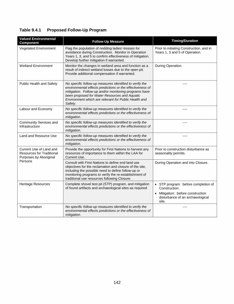
142
Table 9.4.1 Proposed Follow-Up Program
Valued Environmental Component Follow-Up Measure Timing/Duration
Vegetated Environment Flag the population of nodding ladies’-tresses for avoidance during Construction. Monitor in Operation Years 1, 3, and 5 to confirm effectiveness of mitigation. Develop further mitigation if warranted.
Prior to initiating Construction, and in Years 1, 3 and 5 of Operation.
Wetland Environment Monitor the changes in wetland area and function as a result of indirect wetland losses due to the open pit. Provide additional compensation if warranted.
During Operation.
Public Health and Safety No specific follow-up measures identified to verify the environmental effects predictions or the effectiveness of mitigation. Follow-up and/or monitoring programs have been proposed for Water Resources and Aquatic Environment which are relevant for Public Health and Safety.
----
Labour and Economy No specific follow-up measures identified to verify the environmental effects predictions or the effectiveness of mitigation.
----
Community Services and Infrastructure
No specific follow-up measures identified to verify the environmental effects predictions or the effectiveness of mitigation.
----
Land and Resource Use No specific follow-up measures identified to verify the environmental effects predictions or the effectiveness of mitigation.
----
Current Use of Land and Resources for Traditional Purposes by Aboriginal Persons
Provide the opportunity for First Nations to harvest any resources of importance to them within the LAA for Current Use.
Prior to construction disturbance as seasonality permits.
Consult with First Nations to define end land use objectives for the reclamation and closure of the site, including the possible need to define follow-up or monitoring programs to verify the re-establishment of traditional use resources following Closure.
During Operation and into Closure.
Heritage Resources Complete shovel test pit (STP) program, and mitigation of found artifacts and archaeological sites as required
• STP program: before completion of Construction.
• Mitigation: before construction disturbance of an archaeological site.
Transportation No specific follow-up measures identified to verify the environmental effects predictions or the effectiveness of mitigation.
----
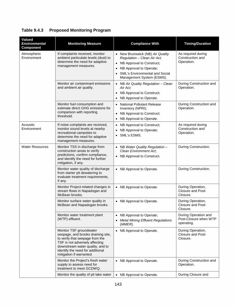
143
Table 9.4.3 Proposed Monitoring Program
Valued Environmental Component
Monitoring Measure Compliance With Timing/Duration
Atmospheric Environment
If complaints received, monitor ambient particulate levels (dust) to determine the need for adaptive management measures.
• New Brunswick (NB) Air Quality Regulation – Clean Air Act;
• NB Approval to Construct; • NB Approval to Operate; • SML’s Environmental and Social
Management System (ESMS).
As required during Construction and Operation.
Monitor air contaminant emissions and ambient air quality.
• NB Air Quality Regulation – Clean Air Act;
• NB Approval to Construct; • NB Approval to Operate.
During Construction and Operation.
Monitor fuel consumption and estimate direct GHG emissions for comparison with reporting threshold.
• National Pollutant Release Inventory (NPRI);
• NB Approval to Construct; • NB Approval to Operate.
During Construction and Operation.
Acoustic Environment
If noise complaints are received, monitor sound levels at nearby recreational campsites to determine the need for adaptive management measures.
• NB Approval to Construct; • NB Approval to Operate; • SML’s ESMS.
As required during Construction and Operation.
Water Resources Monitor TSS in discharge from construction areas to verify predictions, confirm compliance, and identify the need for further mitigation, if any.
• NB Water Quality Regulation – Clean Environment Act;
• NB Approval to Construct.
During Construction.
Monitor water quality of discharge from starter pit dewatering to evaluate treatment requirements, if any.
• NB Approval to Operate. During Construction.
Monitor Project-related changes in stream flows in Napadogan and McBean brooks.
• NB Approval to Operate. During Operation, Closure and Post-Closure.
Monitor surface water quality in McBean and Napadogan brooks.
• NB Approval to Operate. During Operation, Closure and Post-Closure.
Monitor water treatment plant (WTP) effluent.
• NB Approval to Operate; • Metal Mining Effluent Regulations
(MMER).
During Operation and Post-Closure when WTP operating.
Monitor TSF groundwater seepage, and brooks draining site, to verify that seepage from the TSF is not adversely affecting downstream water quality, and to identify the need for additional mitigation if warranted.
• NB Approval to Operate. During Operation, Closure and Post-Closure.
Monitor the Project’s fresh water supply to assess need for treatment to meet GCDWQ.
• NB Approval to Operate. During Construction and Operation.
Monitor the quality of pit lake water • NB Approval to Operate. During Closure and
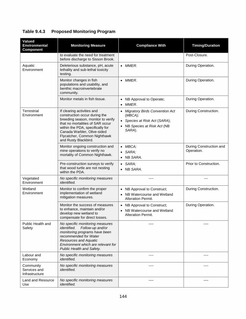
144
Table 9.4.3 Proposed Monitoring Program
Valued Environmental Component
Monitoring Measure Compliance With Timing/Duration
to evaluate the need for treatment before discharge to Sisson Brook.
Post-Closure.
Aquatic Environment
Deleterious substance, pH, acute lethality and sub-lethal toxicity testing.
• MMER. During Operation.
Monitor changes in fish populations and usability, and benthic macroinvertebrate community.
• MMER. During Operation.
Monitor metals in fish tissue. • NB Approval to Operate; • MMER.
During Operation.
Terrestrial Environment
If clearing activities and construction occur during the breeding season, monitor to verify that no mortalities of SAR occur within the PDA, specifically for Canada Warbler, Olive-sided Flycatcher, Common Nighthawk and Rusty Blackbird.
• Migratory Birds Convention Act (MBCA);
• Species at Risk Act (SARA); • NB Species at Risk Act (NB
SARA).
During Construction.
Monitor ongoing construction and mine operations to verify no mortality of Common Nighthawk.
• MBCA; • SARA; • NB SARA.
During Construction and Operation.
Pre-construction surveys to verify that wood turtle are not nesting within the PDA.
• SARA; • NB SARA.
Prior to Construction.
Vegetated Environment
No specific monitoring measures identified.
---- ---
Wetland Environment
Monitor to confirm the proper implementation of wetland mitigation measures.
• NB Approval to Construct; • NB Watercourse and Wetland
Alteration Permit.
During Construction.
Monitor the success of measures to enhance, maintain and/or develop new wetland to compensate for direct losses.
• NB Approval to Construct; • NB Watercourse and Wetland
Alteration Permit.
During Operation.
Public Health and Safety
No specific monitoring measures identified. Follow-up and/or monitoring programs have been recommended for Water Resources and Aquatic Environment which are relevant for Public Health and Safety.
---- ----
Labour and Economy
No specific monitoring measures identified.
---- ----
Community Services and Infrastructure
No specific monitoring measures identified.
---- ----
Land and Resource Use
No specific monitoring measures identified.
---- ----

145
Table 9.4.3 Proposed Monitoring Program
Valued Environmental Component
Monitoring Measure Compliance With Timing/Duration
Current Use of Land and Resources for Traditional Purposes by Aboriginal Persons
Though the EIA confidently predicted no significant environmental effects to traditional foods, monitor potential effects at 2 to 3 traditional use sites identified by First Nations for harvesting of country foods (e.g., fiddleheads, berries, medicinal plants).
---- Prior to Construction, and again within 5 years of the start of Operation.
Heritage Resources Monitor for chance finds of archaeological or paleontological resources. Subject to the results of shovel testing and the completion of the excavation of the archaeological resources identified in the PDA, follow-up archaeological monitoring may be required during ground breaking construction activities in proximity to locations where archaeological resources were discovered.
• NB Approval to Construct; • NB Heritage Conservation Act; • SML’s ESMS.
During Construction.
Transportation No specific monitoring measures identified.
---- ----
Chapter 10 – Summary of Mitigation The narrative text for Chapter 10 includes a brief introduction on page 10 1, followed by Table 10.1.1, which extends over 28 pages. The introductory text begins by explaining that Chapter 8 of the EIA Report identified various mitigation measures for the Project. It notes that these were developed to avoid or minimize the environmental effects of the Project on each applicable valued environmental component (VEC) considered in the EIA.
The Report states that a summary table of the various mitigation measures presented in the environmental effects assessment for each VEC is provided in Table 10.1.1 for convenience. It adds that table 10.1.1. also includes further mitigation measures that were identified in the course of responding to Information Requests (IRs) from the federal and provincial governments arising from their review of the EIA Report.
The Report adds a caution that, in the interests of maintaining the exact language of the text within the EIA Report, the mitigation measures in Chapter 8 of this EIA Report have been reproduced verbatim in the table below, and no editorial changes have been made to the text presented in this table. Where added text was necessary to provide context for the mitigation measure, this added text has been provided in [square brackets and italic text].

146
The Report refers readers to the respective environmental effects assessment for each VEC in Chapter 8 of this EIA Report for a full understanding and the context of mitigation measures to be implemented, to avoid or minimize any adverse environmental effects of the Project. It also notes that acronyms in the table are not spelled out to maintain consistency with the actual text of the mitigation measure as identified in Chapter 8. A List of Acronyms and Units is provided in Appendix A.
Finally, the Report notes that mitigation by design, as described in the Project Description (Chapter 3), is not repeated in this summary table. Only those mitigation measures that are specific to VECs are included.
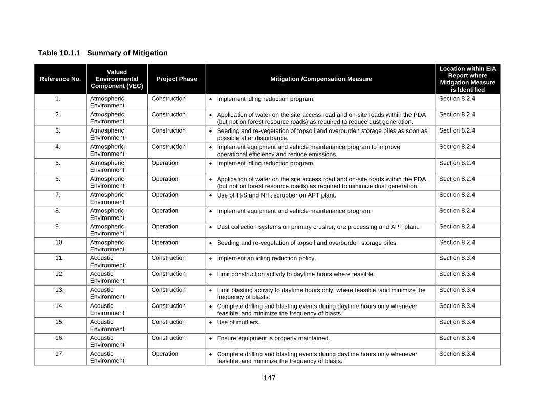
147
Table 10.1.1 Summary of Mitigation
Reference No. Valued
Environmental Component (VEC)
Project Phase Mitigation /Compensation Measure Location within EIA
Report where Mitigation Measure
is Identified 1. Atmospheric
Environment Construction • Implement idling reduction program. Section 8.2.4
2. Atmospheric Environment
Construction • Application of water on the site access road and on-site roads within the PDA (but not on forest resource roads) as required to reduce dust generation.
Section 8.2.4
3. Atmospheric Environment
Construction • Seeding and re-vegetation of topsoil and overburden storage piles as soon as possible after disturbance.
Section 8.2.4
4. Atmospheric Environment
Construction • Implement equipment and vehicle maintenance program to improve operational efficiency and reduce emissions.
Section 8.2.4
5. Atmospheric Environment
Operation • Implement idling reduction program. Section 8.2.4
6. Atmospheric Environment
Operation • Application of water on the site access road and on-site roads within the PDA (but not on forest resource roads) as required to minimize dust generation.
Section 8.2.4
7. Atmospheric Environment
Operation • Use of H2S and NH3 scrubber on APT plant. Section 8.2.4
8. Atmospheric Environment
Operation • Implement equipment and vehicle maintenance program. Section 8.2.4
9. Atmospheric Environment
Operation • Dust collection systems on primary crusher, ore processing and APT plant. Section 8.2.4
10. Atmospheric Environment
Operation • Seeding and re-vegetation of topsoil and overburden storage piles. Section 8.2.4
11. Acoustic Environment:
Construction • Implement an idling reduction policy. Section 8.3.4
12. Acoustic Environment
Construction • Limit construction activity to daytime hours where feasible. Section 8.3.4
13. Acoustic Environment
Construction • Limit blasting activity to daytime hours only, where feasible, and minimize the frequency of blasts.
Section 8.3.4
14. Acoustic Environment
Construction • Complete drilling and blasting events during daytime hours only whenever feasible, and minimize the frequency of blasts.
Section 8.3.4
15. Acoustic Environment
Construction • Use of mufflers. Section 8.3.4
16. Acoustic Environment
Construction • Ensure equipment is properly maintained. Section 8.3.4
17. Acoustic Environment
Operation • Complete drilling and blasting events during daytime hours only whenever feasible, and minimize the frequency of blasts.
Section 8.3.4
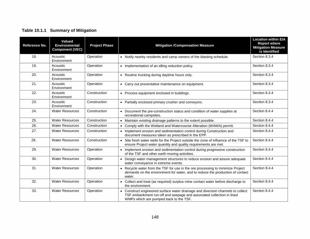
148
Table 10.1.1 Summary of Mitigation
Reference No. Valued
Environmental Component (VEC)
Project Phase Mitigation /Compensation Measure Location within EIA
Report where Mitigation Measure
is Identified 18. Acoustic
Environment Operation • Notify nearby residents and camp owners of the blasting schedule. Section 8.3.4
19. Acoustic Environment
Operation • Implementation of an idling reduction policy. Section 8.3.4
20. Acoustic Environment
Operation • Routine trucking during daytime hours only. Section 8.3.4
21. Acoustic Environment
Operation • Carry out preventative maintenance on equipment. Section 8.3.4
22. Acoustic Environment
Construction • Process equipment enclosed in buildings. Section 8.3.4
23. Acoustic Environment
Construction • Partially enclosed primary crusher and conveyors. Section 8.3.4
24. Water Resources Construction • Document the pre-construction status and condition of water supplies at recreational campsites.
Section 8.4.4
25. Water Resources Construction • Maintain existing drainage patterns to the extent possible. Section 8.4.4 26. Water Resources Construction • Comply with the Wetland and Watercourse Alteration (WAWA) permit. Section 8.4.4 27. Water Resources Construction • Implement erosion and sedimentation control during Construction and
document measures taken as prescribed in the EPP. Section 8.4.4
28. Water Resources Construction • Site fresh water wells for the Project outside the zone of influence of the TSF to ensure Project water quantity and quality requirements are met.
Section 8.4.4
29. Water Resources Operation • Implement erosion and sedimentation control during progressive construction of the TSF and other earth moving activities.
Section 8.4.4
30. Water Resources Operation • Design water management structures to reduce erosion and assure adequate water conveyance in extreme events.
Section 8.4.4
31. Water Resources Operation • Recycle water from the TSF for use in the ore processing to minimize Project demands on the environment for water, and to reduce the production of contact water.
Section 8.4.4
32. Water Resources Operation • Collect and treat (as required) surplus mine contact water before discharge to the environment.
Section 8.4.4
33. Water Resources Operation • Construct engineered surface water drainage and diversion channels to collect TSF embankment run-off and seepage and associated collection in lined WMPs which are pumped back to the TSF.
Section 8.4.4

149
Table 10.1.1 Summary of Mitigation
Reference No. Valued
Environmental Component (VEC)
Project Phase Mitigation /Compensation Measure Location within EIA
Report where Mitigation Measure
is Identified 34. Water Resources Operation • Install and operate groundwater pump-back wells at the northern extent of the
TSF to collect some groundwater seepage that bypasses the collection system for pump back to the WMP and TSF.
Section 8.4.4
35. Water Resources Operation • Implement an adaptive management plan to install groundwater monitoring wells below the TSF WMPs to monitor the groundwater quality, which can be converted to groundwater interception wells should downstream water quality monitoring indicate that seepage is jeopardizing downstream water quality objectives.
Section 8.4.4
36. Water Resources Decommissioning, Reclamation and Closure
• Flood the open pit during Closure to minimize the potential for metal leaching and acid rock drainage (ML/ARD) from the remaining pit walls.
Section 8.4.4
37. Water Resources Decommissioning, Reclamation and Closure
• Maintain ponded water over PAG tailings and waste rock within the TSF to effectively mitigate the potential for ARD/ML.
Section 8.4.4
38. Water Resources Decommissioning, Reclamation and Closure
• Post-Closure, maintain pit lake level to ensure it is a groundwater sink until water quality meets discharge requirements described in the Approval to Operate.
Section 8.4.4
39. Water Resources Decommissioning, Reclamation and Closure
• As required, treat water released from the Project following Closure for as long as necessary to meet discharge water quality requirements.
Section 8.4.4
40. Aquatic Environment
Construction • Fish habitat compensation for direct loss of fish habitat. Section 8.5.4
41. Aquatic Environment
Construction • Relocation of fish from watercourses within the TSF and open pit to nearby watercourses with suitable habitat.
Section 8.5.4
42. Aquatic Environment
Construction • Maintain existing drainage patterns to the extent possible. Section 8.5.4
43. Aquatic Environment
Construction • Comply with the Wetland and Watercourse Alteration (WAWA) permit. Section 8.5.4
44. Aquatic Environment
Construction • Implement erosion and sedimentation control during Construction and document measures taken as prescribed in the EPP.
Section 8.5.4
45. Aquatic Environment
Construction • Siting of Project facilities to minimize disturbance of watersheds and watercourses
Section 8.5.4
46. Aquatic Environment
Operation • Fish habitat compensation for indirect loss of fish habitat. Section 8.5.4

150
Table 10.1.1 Summary of Mitigation
Reference No. Valued
Environmental Component (VEC)
Project Phase Mitigation /Compensation Measure Location within EIA
Report where Mitigation Measure
is Identified 47. Aquatic
Environment Operation • Erosion and sedimentation control during progressive construction of the TSF
and other earth moving activities. Section 8.5.4
48. Aquatic Environment
Operation • Design water management structures to reduce erosion and assure adequate water conveyance in extreme events.
Section 8.5.4
49. Aquatic Environment
Operation • Recycle water from the TSF for use in the ore processing to minimize Project demands on the environment for water, and to reduce the production of contact water.
Section 8.5.4
50. Aquatic Environment
Operation • Treat (as required) surplus mine contact water before discharge to the environment.
Section 8.5.4
51. Aquatic Environment
Operation • Construct engineered drainage collection channels to collect TSF embankment run-off and seepage and associated collection in lined WMPs which are pumped back to the TSF.
Section 8.5.4
52. Aquatic Environment
Operation • Install and operate groundwater pump-back wells below the northwestern TSF embankment to collect some groundwater seepage for return to the TSF.
Section 8.5.4
53. Aquatic Environment
Operation • Implement an adaptive management plan integrated with Follow-up and Monitoring Program to identify the need for and install groundwater monitoring wells below the TSF WMPs to monitor the groundwater quality, which can be converted to groundwater pump-back wells should downstream water quality monitoring indicate that seepage is jeopardizing downstream water quality objectives.
Section 8.5.4
54. Aquatic Environment
Operation • Construct engineered drainage and diversion channels to divert non-contact water around the Project facilities wherever possible.
Section 8.5.4
55. Aquatic Environment
Operation • Construct and operate a water treatment facility to treat surplus water from the Project before discharge, as required.
Section 8.5.4
56. Aquatic Environment
Operation • Adaptive management measures to further reduce seepage in the event that Follow-up and Monitoring Program identifies further mitigation is required.
Section 8.5.4
57. Aquatic Environment
Decommissioning, Reclamation and Closure
• Fish habitat compensation for indirect loss of fish habitat. Section 8.5.4
58. Aquatic Environment
Decommissioning, Reclamation and Closure
• Flood the open pit to minimize potential metal leaching and acid rock drainage (ML/ARD) from remaining pit walls.
Section 8.5.4
59. Aquatic Environment
Decommissioning, Reclamation and Closure
• Maintain ponded water over PAG tailings and waste rock within the TSF to prevent ML/ARD.
Section 8.5.4

151
Table 10.1.1 Summary of Mitigation
Reference No. Valued
Environmental Component (VEC)
Project Phase Mitigation /Compensation Measure Location within EIA
Report where Mitigation Measure
is Identified 60. Aquatic
Environment Decommissioning, Reclamation and Closure
• Treat water released from Project following Closure, as required to meet the conditions of the Approval to Operate.
Section 8.5.4
61. Aquatic Environment
Decommissioning, Reclamation and Closure
• Maintain pit lake level to ensure it is a groundwater sink until water quality meets discharge conditions of the Approval to Operate.
Section 8.5.4
62. Aquatic Environment
Decommissioning, Reclamation and Closure
• Adaptive management measures to further reduce seepage in the event that Follow-up and Monitoring Program identifies further mitigation to be required
Section 8.5.4
63. Terrestrial Environment
Construction and Operation
• SML1 will work with NBDNR and Crown licensees and sub-licensees to communicate information about the Project footprint and schedule for habitat alteration so that it can be factored into broader forest management and other related wildlife management initiatives in the region.
Section 8.6.4
64. Terrestrial Environment
Construction and Operation
• Avoidance of, to the extent feasible, known locations of wildlife SAR and SOCC.
Section 8.6.4
65. Terrestrial Environment
Construction and Operation
• Minimization of the loss or fragmentation of mature forest habitat and interior forest.
Section 8.6.4
66. Terrestrial Environment
Construction and Operation
• Co-location of linear facilities, where possible, to other linear disturbances to minimize the environmental effects of fragmentation.
Section 8.6.4
67. Terrestrial Environment
Construction and Operation
• Minimization of linear corridor width/footprint and clearing to extent practicable. Section 8.6.4
68. Terrestrial Environment
Construction and Operation
• Minimization of size of temporary work spaces. Section 8.6.4
69. Terrestrial Environment
Construction and Operation
• Limiting clearing and grubbing to infrastructure footprint to that which is necessary.
Section 8.6.4
70. Terrestrial Environment
Construction and Operation
• Maintenance of natural buffers around wetlands and riparian zones. Section 8.6.4
71. Terrestrial Environment
Construction and Operation
• Use of down-lighting, a technique of directing night lighting downward so as not to attract migrating birds.
Section 8.6.4
72. Terrestrial Construction and • An Avifauna Management Plan (AMP) to address incidental take. Section 8.6.4
1 After submission of the Sisson Project EIA Report to governments in July 2013, Northcliff Resources Ltd. and Todd Minerals Ltd. entered into a limited partnership agreement to
advance the development of the Sisson Project. As a result of this agreement, the Sisson Project is now being developed and advanced by Sisson Mines Ltd. (SML), on behalf, and as general partner, of the Sisson Project Limited Partnership. Thus, the Proponent of the Sisson Project is now Sisson Mines Ltd., and all references to Northcliff Resources Ltd. (Northcliff) in this document can be read as referring to Sisson Mines Ltd.

152
Table 10.1.1 Summary of Mitigation
Reference No. Valued
Environmental Component (VEC)
Project Phase Mitigation /Compensation Measure Location within EIA
Report where Mitigation Measure
is Identified Environment Operation
73. Terrestrial Environment
Construction and Operation
• Establishment of buffers and protection of active migratory bird nests until fledging, upon their discovery in work areas.
Section 8.6.4
74. Terrestrial Environment
Construction and Operation
• Scheduling of clearing activities outside the breeding season of migratory birds (when possible).
Section 8.6.4
75. Terrestrial Environment
Construction and Operation
• Flag environmentally sensitive areas prior to commencement of clearing and construction.
Section 8.6.4
76. Terrestrial Environment
Construction and Operation
• Development of a wildlife awareness program for Construction and Operation. Section 8.6.4
77. Terrestrial Environment
Construction and Operation
• Permitting the development of shrub vegetation along transmission lines (to the extent practical) to promote their use by wildlife.
Section 8.6.4
78. Terrestrial Environment
Construction and Operation
• Rehabilitate access routes that are no longer needed. Section 8.6.4
79. Terrestrial Environment
Construction and Operation
• Proper storage of food and waste on site so as to avoid the attraction of wildlife to the Project.
Section 8.6.4
80. Terrestrial Environment
Construction and Operation
• Use of approved noise arrest mufflers on all equipment to reduce potential environmental effects of noise.
Section 8.6.4
81. Terrestrial Environment
Construction and Operation
• Implementation of various dust control measures. Section 8.6.4
82. Terrestrial Environment
Construction and Operation
• Vehicle operation at appropriate speed and yielding to wildlife. Section 8.6.4
83. Vegetated Environment
Construction • Clearing activities will be restricted to necessary portions of the PDA, and not beyond.
Section 8.7.4
84. Vegetated Environment
Construction • Standard erosion and sedimentation control measures will be employed, including: • erosion control fencing; • check dams; • sedimentation control ponds where appropriate; • construction sequencing to minimize soil exposure; • retaining existing vegetation as long as possible; • vegetation and mulching of denuded areas; • diverting runoff away from denuded areas; • optimizing length and steepness of slope; • keeping surface water runoff velocities low;
Section 8.7.4

153
Table 10.1.1 Summary of Mitigation
Reference No. Valued
Environmental Component (VEC)
Project Phase Mitigation /Compensation Measure Location within EIA
Report where Mitigation Measure
is Identified • proper sizing and protecting of drainage ways and outlets; • intercepting of sediments on site; and • inspecting and maintaining the above-mentioned control measures.
85. Vegetated Environment
Construction • Clean, coarse fill material will be used for grading, to minimize the risk of introducing or spreading exotic and/or invasive vascular plant species.
Section 8.7.4
86. Vegetated Environment
Construction • Construction machinery will be cleaned prior to entering and leaving wetlands to minimize the risk of introducing or spreading exotic and/or invasive species from one wetland to another.
Section 8.7.4
87. Vegetated Environment
Construction • Any vascular plant SAR or SOCC within or adjacent to the PDA will be flagged and/or fenced off, and construction activities will be minimized in areas adjacent to SAR or SOCC, whenever possible.
Section 8.7.4
88. Vegetated Environment
Construction • NB Power will follow an EPP during the construction of the transmission line and associated infrastructure, which includes mitigation measures for vascular plant SAR or SOCC within the transmission line ROW.
Section 8.7.4
89. Vegetated Environment
Construction • Road construction activities will be minimized in wetland areas to reduce the potential environmental effects of disturbance, such as erosion and sedimentation, and the introduction or spread of exotic and/or invasive vascular plant species.
Section 8.7.4
90. Vegetated Environment
Construction • Forested Crown land that will be removed from the PDA will be accounted for by NBDNR in consideration of the results of this assessment and the appropriate forest licensee in the management plans of the subsequent forest cycle.
Section 8.7.4
91. Vegetated Environment
Construction • NBDNR Conservation Vegetation Communities within the PDA will be replaced within the ecoregion and license block whenever stands meeting the criteria are available. The licensees, the regional NBDNR office, and the NBDNR Fish and Wildlife Branch will collaborate to identify replacement stands.
Section 8.7.4
92. Vegetated Environment
Operation • As part of infrastructure maintenance, access roads will be periodically re-graded and ditched to improve water flow, reduce erosion and/or to deter excessive vegetation growth.
Section 8.7.4
93. Wetland Environment
Construction • Clearing activities will be restricted to necessary portions of the PDA, and not beyond, to minimize the amount of habitat lost or altered through direct disturbance, or adjacent edge effects.
Section 8.8.4

154
Table 10.1.1 Summary of Mitigation
Reference No. Valued
Environmental Component (VEC)
Project Phase Mitigation /Compensation Measure Location within EIA
Report where Mitigation Measure
is Identified 94. Wetland
Environment Construction • Standard erosion and sedimentation control measures will be employed,
including: • erosion control fencing; • check dams; • sedimentation control ponds where appropriate; • construction sequencing to minimize soil exposure; • retaining existing vegetation as long as possible; • re-vegetation and mulching of denuded areas; • diverting runoff away from denuded areas; • optimizing length and steepness of slope; • keeping surface water runoff velocities low; • proper sizing and protecting of drainage ways and outlets; • intercepting of sediments on site; and • inspecting and maintaining the above-mentioned control measures.
Section 8.8.4
95. Wetland Environment
Construction • Any loss of GeoNB-mapped wetlands will be compensated. Section 8.8.4
96. Wetland Environment
Construction • Standard dust control measures will be implemented. Section 8.8.4
97. Wetland Environment
Construction • Quarried, crushed material will be used for road building in and near wetlands, to minimize the risk of introducing or spreading exotic and/or invasive vascular plant species.
Section 8.8.4
98. Wetland Environment
Construction • Road construction activities will be minimized in wetland areas to reduce the potential environmental effects of disturbance, such as erosion and sedimentation, and the introduction or spread of exotic and/or invasive vascular plant species.
Section 8.8.4
99. Wetland Environment
Operation • Water will be treated as necessary prior to release to the environment. Section 8.8.4
100. Wetland Environment
Operation • Invasive species will be managed, as described above for Construction activities.
Section 8.8.4
101. Wetland Environment
Operation • Standard erosion and sedimentation control measures will be employed, as described above for Construction activities.
Section 8.8.4
102. Wetland Environment
Operation • Standard dust control measures will be implemented. Section 8.8.4

155
Table 10.1.1 Summary of Mitigation
Reference No. Valued
Environmental Component (VEC)
Project Phase Mitigation /Compensation Measure Location within EIA
Report where Mitigation Measure
is Identified 103. Public Health and
Safety Construction, Operation, and Decommissioning, Reclamation and Closure
• Mitigation measures as described in Section 8.2.4.2 [Atmospheric Environment] will be employed to reduce air contaminant emissions during Construction and Operation and to reduce people’s exposure to the Project-related air emissions. These include the implementation of an idling reduction policy, the application of water sprays on the site access road and internal site roads in the PDA, the use of dust collection systems on the primary crusher and within the ore processing plant, and the use of scrubbers on the APT plant, among others.
Section 8.9.4
104. Public Health and Safety
Construction, Operation, and Decommissioning, Reclamation and Closure
• Mitigation measures as described in Sections 8.4.4.2 [Water Resources] and 8.5.4.2 [Aquatic Environment] will be employed to reduce metal loadings to the streams, including collection and treatment of surplus mine contact water before discharge to the environment, construction of engineered drainage channels to collect TSF embankment run-off and seepage, flooding the open pit during Closure to minimize the potential for metal leaching and acid rock drainage (ML/ARD) from the pit walls, and provision of water treatment to meet discharge permit requirements post-Closure.
Section 8.9.4
105. Labour and Economy
Construction and Operation
• Qualified local workers will be given priority consideration for Project employment.
Section 8.10.4
106. Labour and Economy
Construction and Operation
• SML will work with local education and training institutions and communicate work requirements to improve the availability of appropriate programs, allowing local people opportunities to gain qualifications for employment.
Section 8.10.4
107. Labour and Economy
Construction and Operation
• Local companies will be given preference for site contract work where qualified companies and suppliers can be identified.
Section 8.10.4
108. Labour and Economy
Construction and Operation
• SML will work with the local business community to communicate requirements and expectations for contracting opportunities and to identify new Project-related business opportunities for local companies.
Section 8.10.4
109. Labour and Economy
Construction and Operation
• SML will continue to engage with the public throughout Operation, allowing sufficient time to plan for and mitigate any adverse environmental effects on Economy that may occur during Decommissioning, Reclamation and Closure.
Section 8.10.4
110. Labour and Economy
Decommissioning, Reclamation and Closure
• SML will continue to engage with the public throughout its planning procedures for Decommissioning, Reclamation and Closure, allowing optimal time to plan for and mitigate environmental effects.
Section 8.10.4

156
Table 10.1.1 Summary of Mitigation
Reference No. Valued
Environmental Component (VEC)
Project Phase Mitigation /Compensation Measure Location within EIA
Report where Mitigation Measure
is Identified 111. Community
Services and Infrastructure
Construction and Operation
• The ESMS will be implemented by the Project to reduce adverse environmental effects and enhance positive environmental effects. The ESMS will be part of all site construction contracts and include all applicable procedures and permit requirements.
Section 8.11.4
112. Community Services and Infrastructure
Construction and Operation
• An Employee Assistance Program will also be offered by the Proponent to its employees. Workforce education to encourage healthy lifestyle choices, sensitivity training, and strict enforcement of the Proponent’s health and safety policies will also serve to mitigate adverse social effects. For example, sensitivity training would raise the level of awareness regarding the potential environmental effects that workers can have on the community and their families through drug and alcohol use or other social concerns.
Section 8.11.4
113. Community Services and Infrastructure
Construction and Operation
• Demands on police services related to Project activities will be reduced by controlling access to the Project site with the use of a security gate and guard house, and by employing on-site security staff.
Section 8.11.4
114. Community Services and Infrastructure
Construction and Operation
• Demands on emergency response services will be reduced by the presence of mine rescue vehicles and trained paramedics at the Project site.
Section 8.11.4
115. Community Services and Infrastructure
Construction and Operation
• The management and provision of many elements of Community Services and Infrastructure is the responsibility of a wide range of government departments and private sector organizations. As described in the ESMS, SML will consult regularly with the relevant agencies and organizations to provide Project information, to identify and address potential Project-related implications for local services and infrastructure, and to support responsible organizations to plan for and adapt to or benefit from any changing demand.
Section 8.11.4
116. Land and Resource Use
Construction and Operation
• Forestry management plans will need to be revised by Crown Timber License Holders to incorporate the harvesting of forestry resources in the PDA as part of Site Preparation. SML will provide information to licensees well in advance of Construction to facilitate planning in collaboration with NBDNR.
Section 8.12.4
117. Land and Resource Use
Construction and Operation
• Where possible in accessible areas (e.g., along cleared right-of-ways), trees and other vegetation will be left in place or encouraged to grow to obstruct the view of Project facilities, reducing the change in viewshed and muffling nuisance noise.
Section 8.12.4
118. Land and Resource Use
Construction and Operation
• The Proponent will communicate with local recreational campsite owners and land owners regarding Project schedule, and the timing of blasting events, to minimize surprise and nuisance.
Section 8.12.4

157
Table 10.1.1 Summary of Mitigation
Reference No. Valued
Environmental Component (VEC)
Project Phase Mitigation /Compensation Measure Location within EIA
Report where Mitigation Measure
is Identified 119. Land and Resource
Use Construction and Operation
• Construction and Operation activities will follow mitigation measures and guidelines outlined in the Environmental and Social Management System (ESMS) to reduce nuisance noise, air emissions, and changes to the viewshed.
Section 8.12.4
120. Land and Resource Use
Construction and Operation
• No trespassing signs will be posted along the perimeter of the Project site to alert local land users of the presence of the Project and its facilities.
Section 8.12.4
121. Current Use of Land and Resources for Traditional Purposes by Aboriginal Persons
Construction • Continued on-going engagement of First Nations throughout the EIA, to develop a sustainable, economically viable and responsible management and reclamation plans for the Project.
Section 8.13.4
122. Current Use of Land and Resources for Traditional Purposes by Aboriginal Persons
Construction • Forestry management plans will be revised by Crown licensees to incorporate the harvesting of forestry resources in the PDA as part of Site Preparation. SML will provide information to Crown licensees (including Aboriginal licensees) well in advance of Construction to facilitate planning in collaboration with NBDNR.
Section 8.13.4
123. Current Use of Land and Resources for Traditional Purposes by Aboriginal Persons
Construction • Work with First Nations and appropriate government agencies to facilitate the harvesting of resources used for traditional purposes in the PDA prior to site preparation activities (where reasonable within the timeframe of planned activities).
Section 8.13.4
124. Current Use of Land and Resources for Traditional Purposes by Aboriginal Persons
Construction • Reclamation of the PDA with consideration of traditional resources, to ensure the land is accessible for traditional purposes post closure of the Project.
Section 8.13.4
125. Current Use of Land and Resources for Traditional Purposes by Aboriginal Persons
Construction • Work to optimize training, employment, and business opportunities of the Project for Aboriginal people.
Section 8.13.4

158
Table 10.1.1 Summary of Mitigation
Reference No. Valued
Environmental Component (VEC)
Project Phase Mitigation /Compensation Measure Location within EIA
Report where Mitigation Measure
is Identified 126. Heritage
Resources Construction • During the course of the archaeological survey conducted in 2011, several
areas of elevated archaeological potential were identified that are recommended for shovel testing within the Project site (Stantec 2012j). It was noted that a redesign of the TSF would avoid two watercourses, and thus, greatly reduce the number of shovel test pits required for the TSF areas. The footprint of the TSF was modified, thus eliminating some of the elevated archaeological potential areas to be affected by Project activities, and reducing the number of required shovel test pits within the TSF. As the location of the open pit is fixed by the location of the ore body, it is not possible to make similar adjustments to the open pit.
Section 8.14.4
127. Heritage Resources
Construction • As mitigation for the Project, a systematic sub-surface test (“shovel testing”) program has been developed and submitted to Archaeological Services for review and approval. This shovel testing will be undertaken by a Permitted archaeologist prior to Construction and Operation disturbance of the areas recommended and approved for shovel testing. The shovel testing will follow the provincial Guidelines (Archaeological Services 2012) and accepted professional standards and practices. The proposed shovel testing strategy is described in the ESMS.
Section 8.14.4
128. Heritage Resources
Construction • The archaeological survey of the 138 kV electrical transmission line will assist in the planning and placement of transmission line towers to avoid elevated areas of archaeological potential areas where possible. Due to the relatively small area of the transmission line towers and base, and the average 160 to 200 m span limit between transmission line towers, NB Power Transmission will attempt to move the location of these towers outside of any areas identified as having elevated potential for archaeological resources. Following the completion of the design of the new transmission line, any areas where towers cannot avoid areas of elevated archaeological potential will be subject to an archaeological survey that will determine detailed shovel testing recommendations that will be provided to Archaeological Services for approval prior to implementation.
Section 8.14.4
129. Heritage Resources
Construction • Any small areas of the PDA that may not have been previously assessed due to minor adjustments in the Project footprint will be assessed prior to initiating Construction, and any recommended mitigation (e.g., shovel testing) will be implemented. These areas likely have low archaeological potential as no additional watercourses or areas considered to hold elevated archaeological potential were identified on the archaeological potential map
Section 8.14.4

159
Table 10.1.1 Summary of Mitigation
Reference No. Valued
Environmental Component (VEC)
Project Phase Mitigation /Compensation Measure Location within EIA
Report where Mitigation Measure
is Identified 130. Heritage
Resources Construction • The specific recommendations of the number of shovel test pits are
documented in the Archaeological Assessment Reports (Stantec 2012k; Stantec 2013a) and have been provided to Archaeological Services. If any archaeological resources are identified during the shovel testing, further mitigation (i.e., archaeological excavation) will be implemented in consultation with Archaeological Services and in accordance with their most current Guidelines (Archaeological Services 2012). Local First Nations will be engaged as appropriate
Section 8.14.4
131. Heritage Resources
Construction • Regarding Lower Lake Dam, should HADD compensation requirements be implemented at this location, a detailed archaeological survey will be completed in order to determine a shovel testing strategy as warranted. Any recommendations for shovel testing will be reviewed and approved by Archaeological Services and completed prior to any proposed ground breaking activities associated with HADD compensation works. In addition, the wooden cribwork will be photographed and monitored during any construction activities as the age of the cribwork has not yet been determined.
Section 8.14.4
132. Heritage Resources
Construction • A heritage resources response procedure will be in place and will be followed in the unlikely event that a heritage resource is discovered during Project-related construction activities as a part of the overall ESMS. In the event of the discovery of a potential archaeological or palaeontological site, all work in this area would immediately be temporarily suspended and a sufficient buffer would be established around the find until it can be fully investigated. If it is confirmed to be a heritage resource, appropriate mitigation will be developed and implemented in consultation with Archaeological Services, the NBM, and First Nations, as appropriate. The heritage resources response procedure will include procedures to be followed in the event of the discovery of archaeological resources, palaeontological resources, and unidentified bone material.
Section 8.14.3
133. Transportation Construction • During Construction, bussing of personnel to/from the Project location from off-site parking lots in Nackawic and Napadogan, and potentially from other towns. For the purposes of this EIA, it is conservatively assumed that bussing will only be to/from the parking lots at Nackawic and Napadogan.
Section 8.15.4
134. Transportation Construction and Operation
• The designation of principal truck routes to the Project site to limit truck traffic to PSA and SSA routes during all phases.
Section 8.15.4
135. Transportation Construction and Operation
• Design of the realignment of the Fire Road will be done in consultation with and approved by NBDNR and in agreement with the Crown Timber Licence Holders.
Section 8.15.4

160
Table 10.1.1 Summary of Mitigation
Reference No. Valued
Environmental Component (VEC)
Project Phase Mitigation /Compensation Measure Location within EIA
Report where Mitigation Measure
is Identified 136. Transportation Construction and
Operation • Adherence to current design standards and best-practices for forest road
construction, for the realignment of the Fire Road and refurbishment of the forest resource roads along the PSA and SSA as required to accommodate two-way Project traffic.
Section 8.15.4
137. Transportation Construction and Operation
• In consultation with NBDNR and the Crown Timber Licence Holders, maintenance of the roadway and roadside warning signs to reduce traffic safety risks along the forest roads that are part of the PSA and SSA routes during all phases.
Section 8.15.4
138. Transportation Construction and Operation
• Best-practices for the maintenance of gravel roads will be implemented, including posting of signage identifying areas under maintenance activities.
Section 8.15.4
139. Transportation Construction and Operation
• In consultation with NBDTI, NBDNR and the Crown Timber Licence Holders, the clearing of bushes along roadsides to improve sight distance at the approaches of the intersections of the RSA and SSA routes at provincial highways during Operation.
Section 8.15.4
140. Transportation Construction and Operation
• Compliance with the existing forest roads best practices that require use of CB radio systems (in SML-controlled vehicles like heavy trucks and buses) for communicating the location of heavy or vehicles among drivers will reduce traffic safety risks along the PSA and SSA routes during all phases.
Section 8.15.4
141. Transportation Construction and Operation
• A Traffic Plan will be developed to guide Project employees and delivery vehicles that specifically identifies roadway hazards along the PSA and SSA routes. The Traffic Plan will include communications and best-practices training and a monitoring and reporting program aimed at reducing traffic safety risks along the PSA and SSA routes for the Operation phase.
Section 8.15.4
142. Effects of the Environment on the Project
Construction and Operation
• As a factor of safety, and a matter of responsible engineering practice, the design and materials to be chosen for construction of the Project will be selected so that the Project will withstand environmental stressors that could occur from various natural and environmental phenomena (e.g., extreme storms, increased precipitation and other factors arising from climate change, and others).
Section 8.16.6
143. Effects of the Environment on the Project
Construction and Operation
• The Project will be built to the standards of the National Building Code of Canada, the Canadian Standards Association (CSA), the Canadian Dam Association (CDA) other codes and standards, and provincial and federal Acts and Regulations. To minimize the potential effects of environmental extremes on the Project, the design of structures and equipment will be compliant with the National Building Code of Canada.
Section 8.16.6

161
Table 10.1.1 Summary of Mitigation
Reference No. Valued
Environmental Component (VEC)
Project Phase Mitigation /Compensation Measure Location within EIA
Report where Mitigation Measure
is Identified 144. Effects of the
Environment on the Project
Construction and Operation
• Other mitigation measures implemented as part of the planning process, including adherence to engineering design codes and standards, use of good engineering judgment and careful construction practices, care in selection of appropriate construction materials and equipment, careful planning of operation activities (e.g., TSF embankment raises; receipt of materials and/or supplies, product deliveries), and the implementation of a proactive monitoring, maintenance and safety management program, will minimize the potential for adverse effects of the environment on the Project to such an extent that they are not significant.
Section 8.16.6
145. Effects of the Environment on the Project
Construction and Operation
• In addition to complying with codes and standards, the Basic Engineering Team for the Project will adopt a proactive approach to incorporate climate change considerations and adaptation measures into the Project. Several publications are available to guide design engineers in this regard, including, for example, the PIEVC (Public Infrastructure Engineering Vulnerability Committee) “Engineering Protocol for Infrastructure Vulnerability Assessment and Adaptation to a Changing Climate” (PIEVC 2011). This protocol outlines a process to assess the infrastructure component responses to changing climate to assist engineers and proponents in effectively incorporating climate change into design, development and management of their existing and planned infrastructure. This and other guidance will be considered, as applicable, in advancing the design and construction of the Project.
Section 8.16.6
146. Effects of the Environment on the Project
Construction and Operation
• The National Building Code of Canada (2010, Volume 2, Appendix C, Division B) provides for factors of safety to account for possible extreme weather (including allowances for future increased frequency and/or severity of these storms that could arise from climate change), and will form the basis of the design and construction of the Project-related buildings and structures. The TSF will be constructed to meet the Dam Safety Guidelines (Canadian Dam Association 2007) of the Canadian Dam Association and with sufficient capacity and freeboard to store the probable maximum precipitation at all times during operations and into Post-Closure.
Section 8.16.6
147. Effects of the Environment on the Project
Construction and Operation
• Many of the major structures, such as the TSF, will be constructed in stages throughout the Project life; the design criteria will be reassessed prior to construction of each new stage, and this will provide an opportunity to ensure that any observed or predicted changes in the environmental are accounted for in the design. As a result, structures will be designed such that they will be able to withstand extremes of temperature, wind, rain, snow, and ice events through the life of the Project and into Post-Closure (as applicable).
Section 8.16.6

162
Table 10.1.1 Summary of Mitigation
Reference No. Valued
Environmental Component (VEC)
Project Phase Mitigation /Compensation Measure Location within EIA
Report where Mitigation Measure
is Identified 148. Effects of the
Environment on the Project
Construction and Operation
• As such, the Project and related facilities and infrastructure will be designed to account for a one-in-2,500-year seismic event. Furthermore, the TSF will be constructed to meet the guidelines of the Canadian Dam Association for a one-in-5,000-year seismic event, which are also developed to withstand reasonably probable seismic activity.
Section 8.16.6
149. Effects of the Environment on the Project
Construction and Operation
• A cleared buffer will be maintained around Project infrastructure, where feasible, that would reduce the potential for a fire to affect the structures (which given the nature of the materials they contain are inherently fire resistant).
Section 8.16.6
150. Effects of the Environment on the Project
Construction and Operation
• Firefighting capabilities (including appropriate equipment) on-site will be at a high level of training and readiness. The safety and security programs will be in place in conjunction with facility, community, and provincial emergency response crews to provide for rapid detection and response to any fire threat.
Section 8.16.6
151. Accidents, Malfunctions and Unplanned Events - Erosion and Sediment Control
All phases • If required, [in the case of an Erosion and Sediment Control Failure] SML will provide an alternate drinking water source (such as bottled water) or post known surface water collection sites until parameters return to acceptable levels.
Section 8.17.3.1
152. Accidents, Malfunctions and Unplanned Events - Erosion and Sediment Control
All phases • The water quality monitoring program to be developed and implemented during normal operating conditions would detect any exceedances of drinking water guidelines arising from [an Erosion and Sediment Control Failure]. As these exceedances would be temporary and measures will be in place to monitor water quality and notify potential users and provide alternate drinking water source if required, the potential for this event to affect Public Health and Safety can be effectively mitigated.
Section 8.17.3.1
153. Accidents, Malfunctions and Unplanned Events – Pipeline Leak
Operation • Mitigation measures will be in place to prevent [a Pipeline Leak] from occurring including regular maintenance and inspection of equipment, use of drip trays, training of staff in the proper use of fueling equipment, implementation of safe procedures for this activity, and use of designated areas for refueling which are at least 30 m from any watercourse or wetland. Spill kits will be maintained on-site and employees will be trained in their use. Contingency and emergency response procedures will be documented in the ESMS, and employees will be trained in the safe response and reporting procedures.
Section 8.17.3.2

163
Table 10.1.1 Summary of Mitigation
Reference No. Valued
Environmental Component (VEC)
Project Phase Mitigation /Compensation Measure Location within EIA
Report where Mitigation Measure
is Identified 154. Accidents,
Malfunctions and Unplanned Events - On-site hazardous material spill
All phases • The following measures will be in place to reduce or eliminate the potential for a major release arising from an on-site hazardous material spill: • the provision of impermeable containment berms (or other forms of
secondary containment); • placement of protective barriers as appropriate; • the establishment of groundwater monitoring wells around the TSF; • regular inspection of all components of the TSF; • provision of alarms on secondary containment measures; • careful implementation of fuel transfer operations; and • provision of an emergency response plan for the immediate isolation and
clean-up of a release.
Section 8.17.3.3
155. Accidents, Malfunctions and Unplanned Events - On-site hazardous material spill
All phases • Guidance documents such as the CCME Environmental Code of Practice for Aboveground and Underground Storage Tank Systems Containing Petroleum and Allied Petroleum Products (CCME 2003) will be followed. Specifically, the Code of Practice indicates that above-ground petroleum storage tanks must have: • corrosion protection; • secondary containment; • leak detection; • overfill protection (alarm); • containment sumps; and • piping in accordance with Part 5 of the Code.
Section 8.17.3.3
156. Accidents, Malfunctions and Unplanned Events - On-site hazardous material spill
All phases • SML will develop an Environmental Emergency Plan as part of the overall Emergency Response Plan (ERP) in order to effectively manage the hazardous materials that will be stored on-site.
Section 8.17.3.3
157. Accidents, Malfunctions and Unplanned Events - On-site hazardous material spill
All phases • The ERP will describe measures taken to prevent any unplanned releases and to mitigate the effects of such a release should it occur. The MMER specify that the ERP must include the following: • identification of accidental spills that can reasonably be expected to occur
and the potential damage or danger that could result (i.e., a site risk analysis);
• a description of the measures to be used to prevent, prepare for, and respond to an accidental release of a deleterious substance;
Section 8.17.3.3
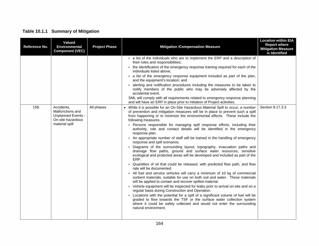
164
Table 10.1.1 Summary of Mitigation
Reference No. Valued
Environmental Component (VEC)
Project Phase Mitigation /Compensation Measure Location within EIA
Report where Mitigation Measure
is Identified • a list of the individuals who are to implement the ERP and a description of
their roles and responsibilities; • the identification of the emergency response training required for each of the
individuals listed above; • a list of the emergency response equipment included as part of the plan,
and the equipment’s location; and • alerting and notification procedures including the measures to be taken to
notify members of the public who may be adversely affected by the accidental event.
SML will comply with all requirements related to emergency response planning and will have an ERP in place prior to initiation of Project activities.
158. Accidents, Malfunctions and Unplanned Events - On-site hazardous material spill
All phases • While it is possible for an On-Site Hazardous Material Spill to occur, a number of prevention and mitigation measures will be in place to prevent such a spill from happening or to minimize the environmental effects. These include the following measures. • Persons responsible for managing spill response efforts, including their
authority, role and contact details will be identified in the emergency response plan.
• An appropriate number of staff will be trained in the handling of emergency response and spill scenarios.
• Diagrams of the surrounding layout, topography, evacuation paths and drainage flow paths, ground and surface water resources, sensitive ecological and protected areas will be developed and included as part of the ERP.
• Quantities of oil that could be released, with predicted flow path, and flow rate will be documented.
• All fuel and service vehicles will carry a minimum of 10 kg of commercial sorbent materials, suitable for use on both soil and water. These materials will be applied to contain and recover spilled material.
• Vehicle equipment will be inspected for leaks prior to arrival on-site and on a regular basis during Construction and Operation.
• Locations with the potential for a spill of a significant volume of fuel will be graded to flow towards the TSF or the surface water collection system where it could be safely collected and would not enter the surrounding natural environment.
Section 8.17.3.3

165
Table 10.1.1 Summary of Mitigation
Reference No. Valued
Environmental Component (VEC)
Project Phase Mitigation /Compensation Measure Location within EIA
Report where Mitigation Measure
is Identified • Roadside ditches within the property with regularly spaced culverts will also
help to contain spills as the culverts could be blocked to stop the spread of spilled materials.
• All fuel storage and distribution infrastructure will be constructed to modern engineering standards and will be approved under provincial legislation requirements.
• Storage of liquid petroleum, and refueling of machinery will not occur within 30 m of any watercourse or wetland.
• The incorporation of road design features for Project roads within the PDA (such as speed limits and passing bays).
• An ERP will be developed and included as part of the ESMS. The response plan will outline procedures for containing and cleaning up spills in a safe and efficient manner, and associated federal and provincial reporting requirements. Spill response kits will be available at the Project-site during all phases of the Project to minimize any potential adverse environmental effects.
• Measures for spill containment and spill emergency response and environmental protection will be in place before any potentially hazardous materials are brought on-site. These will be outlined in the EPRP.
• All bulk explosives spills must be dealt with quickly for safety and environmental reasons. Product must be recovered quickly by means of a non-sparking shovel and brooms. Spills management will use recommended best practice for clean-up of any spills for the chemicals involved with commercial explosives.
159. Accidents, Malfunctions and Unplanned Events - On-site hazardous material spill
All phases • In the unlikely event of a spill of any material, emergency containment and recovery procedures developed in the ERP will include: • immediate containment and recovery of spill material using equipment
includes a variety of booms, barriers, sand bags, and skimmers, as well as natural and synthetic sorbent materials;
• containment measures will immediately be initiated to limit the spread of the spill;
• any nearby drainage (non-watercourse) culverts will be blocked to limit spill migration if required;
• if the spill source is from a leaking fuel truck, the tanker will be pumped dry and transferred into another tanker or other appropriate and secure container(s) and the leak will be repaired immediately;
Section 8.17.3.3

166
Table 10.1.1 Summary of Mitigation
Reference No. Valued
Environmental Component (VEC)
Project Phase Mitigation /Compensation Measure Location within EIA
Report where Mitigation Measure
is Identified • excavation and removal of hydrocarbon saturated soil for temporary storage,
and eventual permanent treatment/disposal; • interception and removal of hydrocarbon entrapped within the fractured
bedrock using recovery wells and immiscible scavenger methods; • repair of an secondary containment breach; • conduct post-spill response investigation to evaluate the performance of spill
prevention measures; • collect post-response samples of soil and water for testing; and • any equipment cleaning that is required as a result of a leak or spill on the
equipment will be implemented in a confined area where the wash water can be collected for proper disposal.
160. Accidents, Malfunctions and Unplanned Events - Release of Off-Specification Effluent from Water Treatment Plant
Operation • All effluent released from the Project will be monitored to verify that it meets MMER or other effluent quality requirements as defined by the approvals or permits to be issued for the Project. In the event that contaminant limits above the permitted levels are indicated, the Water Treatment Plant will be temporarily shut down until repairs to the facility can be implemented and/or changes to the treatment process can be implemented in order to meet the permitted levels for effluent release.
Section 8.17.3.4
161. Accidents, Malfunctions and Unplanned Events - Release of Off-Specification Effluent from Water Treatment Plant
Operation • The planned monitoring program for Operation would also be effective in detecting any changes that may affect public health and safety. If necessary, warning and public advisories will be posted and broadcasted to potential resource users. The area downstream of Sisson Brook that may be affected is not heavily used for hunting, trapping and fishing and there are alternative locations that could be accessed should a restriction of resource use be required as a result of the Project. Again, with monitoring and notification procedures in place, this malfunction is unlikely to result in residual adverse environmental effects to Public Health and Safety.
Section 8.17.3.4
162. Accidents, Malfunctions and Unplanned Events - Release of Off-Specification Effluent from Water Treatment Plant
Operation • Prior to Construction, surface water users in the area will be identified to allow SML to inform any potentially affected users in a timely manner. If required, [in the event of a Release of Off-Specification Effluent from Water Treatment Plant] SML will provide an alternate drinking water source (such as bottled water) until parameters return to acceptable levels.
Section 8.17.3.4

167
Table 10.1.1 Summary of Mitigation
Reference No. Valued
Environmental Component (VEC)
Project Phase Mitigation /Compensation Measure Location within EIA
Report where Mitigation Measure
is Identified 163. Accidents,
Malfunctions and Unplanned Events – Failure of Water Management Pond
Operation • While it is possible for water management pond pumps to temporarily fail due to mechanical failure or loss of power, a number of mitigation measures will be in place to prevent such a failure from resulting in an overflow of the ponds. These include: • the design of the ponds to store inflow volume resulting from a 1 in 10-year
design flood event within 10 days, and will maintain sufficient freeboard to allow time for repairs to the pump, should it fail;
• level control instrumentation and level alarms will monitor water levels within the water management ponds to prevent overflow, and regular visual inspection of the ponds by site personnel, particularly preceding and following large precipitation events;
• regular inspection and maintenance of pumps to minimize the potential for unanticipated failure;
• maintain replacement pumps on-site to allow timely replacement in the event of a mechanical failure;
• provision of emergency generators on-site to power necessary equipment in the event of a longer-term power outage; and
• prior to any forecasted extreme precipitation event, checking and further reduction of water levels in the ponds prior to the event if deemed necessary.
Section 8.17.3.5
164. Accidents, Malfunctions and Unplanned Events – Failure of Water Management Pond
Operation • Prior to Construction, surface water users in the area will be identified to allow SML to inform any potentially affected users in a timely manner. If required, SML will provide an alternate drinking water source (e.g., bottled water) until parameters return to acceptable levels.
165. Accidents, Malfunctions and Unplanned Events – Off-Site Trucking Accident
Construction and Operation
• While this assessment focuses on the emergency response and other post-spill mitigation, it must be considered that various measures are in place to prevent such accidents from happening in the first place. A description of such measures in place is presented below: • purchasing reagents from reliable suppliers who use well qualified and
experienced transport contractors; • imposing speed limits on non-regulated access roads; • provide communication along access roads such that emergency response
personnel and equipment can be notified and mobilized in a timely fashion; • engaging only reputable shipping contractors and shipping companies that
have sound emergency procedures in place throughout the handling chain and regularly audit their performance;
Section 8.17.3.6

168
Table 10.1.1 Summary of Mitigation
Reference No. Valued
Environmental Component (VEC)
Project Phase Mitigation /Compensation Measure Location within EIA
Report where Mitigation Measure
is Identified • requiring all containers (drums/barrels) loaded onto trucks to be blocked or
tied down with hardware adequate to prevent the load from shifting on the vehicle;
• requiring that no person drives or operates a vehicle carrying a load unless the load is properly secured;
• requiring that all drivers be trained in emergency response and that the transport vehicles carry appropriate spill containment and neutralizing agents and are trained in their use as appropriate;
• clearly defining all shipping routes, and identifying all critical areas such as sources of community drinking water;
• consulting with regional officials along the transportation route to ensure that they are aware of the associated risks;
• assisting community leaders within the local site area in the development of local EPRP and training local people;
• having a designated coordinator to ensure that the public and local authorities are notified in a timely fashion with appropriate and accurate information should a spill occur; and
• addressing off-site chemical and/or fuel spills in the ESMS. 166. Accidents,
Malfunctions and Unplanned Events – Off-Site Trucking Accident
Construction and Operation
• Soil and vegetation affected by a spill can be remediated through standard response and clean-up procedures such that long-term or significant environmental effects are not anticipated.
Section 8.17.3.6
167. Accidents, Malfunctions and Unplanned Events – Off-Site Trucking Accident
Construction and Operation
• Should any spill occur with the potential of contaminating ground or surface drinking water resources or contaminating surface water used by the public for recreational purposes such as swimming, public notifications would be issued in conjunction with Provincial authorities. If required, alternate drinking water (i.e., bottled water) would be supplied to affected users and monitoring of water quality would be conducted until such time as water quality returns to pre-spill conditions and known publically accessed water sources could be posted as non-potable.
Section 8.17.3.6
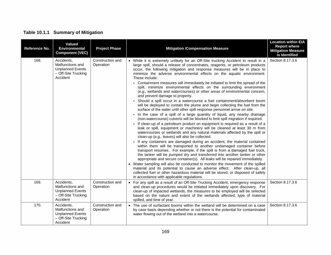
169
Table 10.1.1 Summary of Mitigation
Reference No. Valued
Environmental Component (VEC)
Project Phase Mitigation /Compensation Measure Location within EIA
Report where Mitigation Measure
is Identified 168. Accidents,
Malfunctions and Unplanned Events – Off-Site Trucking Accident
Construction and Operation
• While it is extremely unlikely for an Off-Site trucking Accident to result in a large spill, should a release of concentrates, reagents, or petroleum products occur, the following mitigation and response measures will be in place to minimize the adverse environmental effects on the aquatic environment. These include: • Containment measures will immediately be initiated to limit the spread of the
spill, minimize environmental effects on the surrounding environment (e.g., wetlands and watercourses) or other areas of environmental concern, and prevent damage to property.
• Should a spill occur in a watercourse a fuel containment/absorbent boom will be deployed to contain the plume and begin collecting the fuel from the surface of the water until other spill response personnel arrive on site.
• In the case of a spill of a large quantity of liquid, any nearby drainage (non-watercourse) culverts will be blocked to limit spill migration if required.
• If clean-up of a petroleum product on equipment is required as a result of a leak or spill, equipment or machinery will be cleaned at least 30 m from watercourses or wetlands and any natural materials affected by the spill or clean-up (e.g., leaves) will also be collected.
• If any containers are damaged during an accident, the material contained within them will be transported to another undamaged container before transport resumes. For example, if the spill is from a damaged fuel truck, the tanker will be pumped dry and transferred into another tanker or other appropriate and secure container(s). All leaks will be repaired immediately.
• Water sampling will also be conducted to monitor the movement of the spilled material and its potential to cause an adverse effect. After clean-up, all collected fuel or other hazardous material will be stored, or disposed of safely in accordance with applicable regulations.
Section 8.17.3.6
169. Accidents, Malfunctions and Unplanned Events – Off-Site Trucking Accident
Construction and Operation
• For any spill as a result of an Off-Site Trucking Accident, emergency response and clean-up procedures would be initiated immediately upon discovery. For clean-up of impacted wetlands, the measures to be employed will be selected based on the nature and extent of the wetlands affected, type of material spilled, and time of year.
Section 8.17.3.6
170. Accidents, Malfunctions and Unplanned Events – Off-Site Trucking Accident
Construction and Operation
• The use of surfactant booms within the wetland will be determined on a case by case basis depending whether or not there is the potential for contaminated water flowing out of the wetland into a watercourse.
Section 8.17.3.6
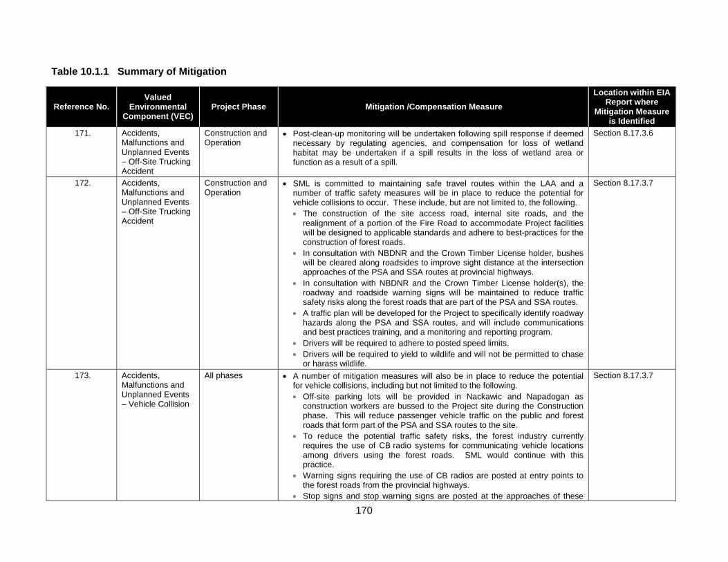
170
Table 10.1.1 Summary of Mitigation
Reference No. Valued
Environmental Component (VEC)
Project Phase Mitigation /Compensation Measure Location within EIA
Report where Mitigation Measure
is Identified 171. Accidents,
Malfunctions and Unplanned Events – Off-Site Trucking Accident
Construction and Operation
• Post-clean-up monitoring will be undertaken following spill response if deemed necessary by regulating agencies, and compensation for loss of wetland habitat may be undertaken if a spill results in the loss of wetland area or function as a result of a spill.
Section 8.17.3.6
172. Accidents, Malfunctions and Unplanned Events – Off-Site Trucking Accident
Construction and Operation
• SML is committed to maintaining safe travel routes within the LAA and a number of traffic safety measures will be in place to reduce the potential for vehicle collisions to occur. These include, but are not limited to, the following. • The construction of the site access road, internal site roads, and the
realignment of a portion of the Fire Road to accommodate Project facilities will be designed to applicable standards and adhere to best-practices for the construction of forest roads.
• In consultation with NBDNR and the Crown Timber License holder, bushes will be cleared along roadsides to improve sight distance at the intersection approaches of the PSA and SSA routes at provincial highways.
• In consultation with NBDNR and the Crown Timber License holder(s), the roadway and roadside warning signs will be maintained to reduce traffic safety risks along the forest roads that are part of the PSA and SSA routes.
• A traffic plan will be developed for the Project to specifically identify roadway hazards along the PSA and SSA routes, and will include communications and best practices training, and a monitoring and reporting program.
• Drivers will be required to adhere to posted speed limits. • Drivers will be required to yield to wildlife and will not be permitted to chase
or harass wildlife.
Section 8.17.3.7
173. Accidents, Malfunctions and Unplanned Events – Vehicle Collision
All phases • A number of mitigation measures will also be in place to reduce the potential for vehicle collisions, including but not limited to the following. • Off-site parking lots will be provided in Nackawic and Napadogan as
construction workers are bussed to the Project site during the Construction phase. This will reduce passenger vehicle traffic on the public and forest roads that form part of the PSA and SSA routes to the site.
• To reduce the potential traffic safety risks, the forest industry currently requires the use of CB radio systems for communicating vehicle locations among drivers using the forest roads. SML would continue with this practice.
• Warning signs requiring the use of CB radios are posted at entry points to the forest roads from the provincial highways.
• Stop signs and stop warning signs are posted at the approaches of these
Section 8.17.3.7

171
Table 10.1.1 Summary of Mitigation
Reference No. Valued
Environmental Component (VEC)
Project Phase Mitigation /Compensation Measure Location within EIA
Report where Mitigation Measure
is Identified forest roads to the provincial highways.
• The realignment of the Fire Road will widen the travelling surface to allow for continuous two-way passing traffic.
• In consultation with the NBDNR and the Crown Timber License holder(s), bushes will be cleared along roadsides to improve sight distance at the intersection approaches of the PSA and SSA routes at provincial highways.
• In consultation with NBDNR and the Crown Timber License holder(s), the roadway and roadside warning signs will be maintained to reduce traffic safety risks along the forest roads that are part of the PSA and SSA routes.
• Signage advising motorists of construction activities in the area and traffic pattern changes will be posted at regular intervals on the forest roads in accordance with current safety and construction standards and best practices for the construction of forest roads.
• The physical construction of the site access road and internal site roads, in and of itself, will not result in increased traffic levels travelling on the PSA or SSA routes, although it will facilitate the safe and effective movement of vehicles through the LAA.
• The development and application of a Traffic Plan to specifically identify roadway hazards along the PSA and SSA routes, and that includes a communications and best practices training, monitoring and reporting program, will reduce traffic safety risks along these roads.
Revised or Additional Mitigation Measures Resulting from EIA Report Information Requests (IRs) 175.
NB-01A-13 and NRCan-01-06
N/A Engineering and Design
Further seepage mitigation strategies will be developed during Basic Engineering and detailed design that may include: grouting of fractured rock, compacting a soil liner in certain areas, and installing a HDPE or other synthetic liner upstream over certain features. The design will ensure that the performance criteria assumed for the TSF (e.g. seepage rates) will be achieved.
Sections 3.2.4.3.1 and 8.4.7
176. NB-01A-132
Aquatic Environment
Decommissioning, Reclamation and Closure.
Prior to initiation of water releases from the open pit lake, the prevailing water quality conditions in the lake will be established via limnological studies; the timeline and specific content of such studies will be determined with the regulator during Decommissioning, Reclamation and Closure. The water management system will be reconfigured to ensure that all water discharged from the open pit lake can be treated, if needed, to meet discharge permit requirements for as long as is required. While such treatment is needed, the elevation of the pit lake will be managed to ensure that groundwater flows into, and not out of, it by pumping the lake water to the water treatment plant before discharge.
Section 8.5.4.2.5

172
Table 10.1.1 Summary of Mitigation
Reference No. Valued
Environmental Component (VEC)
Project Phase Mitigation /Compensation Measure Location within EIA
Report where Mitigation Measure
is Identified 177.
NB-01A-151 Terrestrial Environment
The loss of terrestrial habitat could potentially reduce the availability of habitat used by Canada Warbler, Olive-sided Flycatcher and Rusty Blackbird, though the extent of removal will be small in comparison to available habitat in and near the LAA and RAA. There are no features of the terrestrial habitat within the PDA affected by the Project that would eliminate habitat for these species that is not available elsewhere (and, in fact, abundant) in the RAA. No direct mortality of these species due to the Project is expected with planned mitigation such as: • avoidance of, to the extent feasible, known locations of these species; • minimization of the loss or fragmentation of mature forest habitat and interior
forest; • co-location of linear facilities, where possible, to other linear disturbances to
minimize the environmental effects of fragmentation; • minimization of linear corridor width/footprint and clearing to extent practicable; • minimization of size of temporary work spaces; • limiting clearing and grubbing to infrastructure footprint to that which is
necessary; • maintenance of natural buffers around wetlands and riparian zones; • use of down-lighting, a technique of directing night lighting downward so as not
to attract migrating birds; • establishment of buffers and protection of active nests until fledging, upon their
discovery in work areas; • scheduling of clearing activities outside the breeding season of (when
possible); • use of approved noise arrest mufflers on all equipment to reduce potential
environmental effects of noise; • implementation of various dust control measures; • vehicle operation at appropriate speed; and • implementation of a monitoring plan. • development of a wildlife awareness program for Construction and Operation; • rehabilitate access routes that are no longer needed; • proper storage of food and waste on site so as to avoid the attraction of wildlife
to the Project; • vehicle operation at appropriate speed and yielding to wildlife.
Section 8.6.2.5

173
Table 10.1.1 Summary of Mitigation
Reference No. Valued
Environmental Component (VEC)
Project Phase Mitigation /Compensation Measure Location within EIA
Report where Mitigation Measure
is Identified 178.
NB-01B-309 Water Resources Engineering and
Design Without mitigation and the proper siting of groundwater well(s) outside the zone of influence of the Project, tThe supply and quality of the freshwater supply could be affected by both the presence of the TSF and the open pit. Additional site investigation during Basic and Detailed Engineering will inform the siting of the water supply well(s) and confirm the well location(s) prior to Construction. Monitoring of the water quality and water levels will be necessary to confirm the continued safe use of this water supply during Operation.”
Section 8.4.4.3.2
179. NRCan-01-04
Water Resources Operation The contingency plan for a Release of Off-Specification Effluent from Water Treatment Plant will be integrated into the Environmental Management Plan and Emergency Preparedness and Response Plan as a part of the overall Environmental and Social Management System described in Section 2.6 of the EIA Report and in its Appendix D. If regular monitoring indicates that the water treatment plant (WTP) effluent exceeds specifications, the discharge would be immediately stopped and redirected to the Tailings Storage Facility (TSF). The TSF will have adequate capacity to manage such water during temporary shut-down of the WTP. An investigation to determine the nature and cause of the exceedance would be initiated. The required actions to restore proper WTP operations would be implemented as soon as possible and prior to any further release of off-specification effluent to the natural environment. Should the causative factors require an adaptive approach to restore normal operations, SML will develop and implement an adaptive management plan in consultation with the appropriate regulatory authorities. This scenario will be incorporated into the final water balance modelling used for basic engineering of the WTP to assess the impact of various lengths of plant downtime, and ensure the TSF has the capacity required to accept off-specification water.
Section 2.6 and Appendix D
180. NRCan-01-05
Water Resources Construction and Operation
During Construction and Operation, the pit will be actively de-watered with pumps, and the water level in the pit will be at or near the pit floor. After the pit fills during Closure, the level of the pit lake will be maintained by pumping the water for treatment and discharge to Sisson Brook. Piezometric levels in the vicinity of the pit will be monitored during Closure and Post-Closure to verify that pit lake levels are maintained such that the lake is a groundwater sink. Since the pit lake elevation will be kept lower than the groundwater table elevation around the pit, the relative water pressures across the pit walls will ensure that ground water flows into the pit via the overburden, the fractured bedrock below it, and any fractures that may exist in the competent bedrock at lower elevations. If deep fractures exist that could be potential pathways for
Appendix D

174
Table 10.1.1 Summary of Mitigation
Reference No. Valued
Environmental Component (VEC)
Project Phase Mitigation /Compensation Measure Location within EIA
Report where Mitigation Measure
is Identified groundwater leakage, they will be evident as inflow sources during Operation. The information collected during detailed design investigations, and subsequent mining, will be used to assess the potential for groundwater leakage during and after Closure, and develop appropriate mitigation measures for those leakages if necessary. Such mitigation measures may include, as necessary, grouting of fractures and pressure relief wells in the pit walls. The Environmental Management Plan will incorporate these planned and adaptive management measures to address such matters, all following the basic approach outlined in the ESMS in Appendix D of the EIA Report.
181. EC-01-20
N/A Operation The mid-grade ore stockpile will placed in the TSF in successive lifts throughout the operating life of the mine. The current mine plan shows that some material in this stockpile will be un-submerged for approximately 20 years. It is standard practice for active mines to include sampling of dump crests during Operation to confirm ML/ARD predictions, and this would be implemented for the mid-grade ore stockpile. Acid-base accounting tests would be performed on crest samples to help determine if oxidation rates were occurring faster or slower than the prediction. Run-off and seepage from the mid-grade ore may also be monitored for water quality, which could also be used to assess sulphide oxidation rates and assess water quality. In the event that testing indicated the mid-grade ore stockpile was going to produce ARD before it was submerged, a number of mitigation measures could be considered, including: • revise the mine plan such that mid-grade ore is submerged more quickly; • move exposed mid-grade ore to a lower elevation to ensure that it is flooded
and encapsulated faster than the onset of ARD (likely be done with dozers); and
• mill and process the mid-grade ore in the ore processing plant.
Section 7.5.2.3
182. EC-01-29
Terrestrial Environment
Construction Edits to 8.6.4.2, addition of the following bullet: ………… The following general mitigation measures will be employed to avoid or reduce potential environmental effects of the Project on the Terrestrial Environment: • use of visual and auditory deterrents (such as bird scaring tape) within cleared
work areas to deter the use of these areas by ground-nesting bird species;
Section 8.6.4.2

175
Table 10.1.1 Summary of Mitigation
Reference No. Valued
Environmental Component (VEC)
Project Phase Mitigation /Compensation Measure Location within EIA
Report where Mitigation Measure
is Identified 183.
EC-01-30 Terrestrial Environment
Construction and Operation
Section 8.6.4.2 (Page 8-310) of the Final EIA Report will be amended to add the following bullet to the list of general mitigation measures that will be employed to avoid or reduce potential environmental effects of the Project on the Terrestrial Environment: • As part of the Avifauna Management Plan, identify measures to prevent use of
large piles of soil by Bank Swallows or other burrowing bird species, and identify measures to protect nesting birds if soil piles are used during the breeding season.
Section 8.6.4.2
184. EC-01-31
Terrestrial Environment
Construction The following edit will be made to page 8-311 of the EIA Report, within the bullet list describing the components of an AMP (added text in underline): • “mitigation measures, including:
• general mitigation measures designed to reduce the likelihood of interaction with birds during clearing and other construction activities (including beaver dam removal);”
Section 8.6.4.2
185. CEA-05-01, Table 9.1,
Concern #9 and 10
Heritage Resources
Construction SML is proposing to establish and Archaeology Working Group and is funding a First Nations independent archaeologist to facilitate communication and understanding of the archaeological mitigation that is being implemented in 2014 and beyond.
N/A
186. EC-04-04(f)
Terrestrial Environment
All phases SML will take measures to avoid incidental take of birds, nests, eggs, and chicks for all Project-related activities and during all Project phases and avoid/minimize adverse environmental effects of the Project on avian SAR, through the implementation of the approved Avifauna Management Plan.
Section 8.6.4.2
187. CEA-05-01 Table 9.1,
Concerns #1, 2, 9, and 13
Terrestrial Environment
All phases SML will participate in and be supportive of a broader study of the sustainability of traditional First Nations wildlife resource use in the Crown land block in which the Project is located.
N/A
188. CEA-05-01 Table 9.1,
Concern #18
Follow-up and Monitoring
All phases SML undertook to provide more information about how it will involve First Nations in the development and implementation of follow-up and monitoring programs. SML prepared a draft “Sisson Project: Proposed Framework for First Nations Participation in the Follow-Up and Monitoring Program” which was discussed at a FNEAWG meeting held on October 8, 2014. First Nations undertook to provide SML with a second draft of the document based on discussions at that meeting.
N/A

176
Chapter 11 - Conclusions This final Chapter of the Report summarizes the process followed by the Stantec Study Team in conducting EIA, as well as its ultimate conclusions.
The Report states that, in accordance with the requirements of CEAA, the NB EIA Regulation, the Provincial Final Guidelines and the Terms of Reference that also serve as EIA Guidelines under CEAA, this EIA Report has included a discussion and assessment of the following elements.
• Following some introductory context, a discussion of the planning of the Project was provided, including a brief overview of the worldwide supply and demand for tungsten and molybdenum, the purpose/rationale/need for the Project and alternatives to it, and project planning and management strategies that will be implemented as part of the Project to manage its environmental effects.
• A detailed Project Description of the proposed elements of the Sisson Project was provided, including the consideration of alternative means of carrying out the Project, and a discussion of how the Project will be constructed, operated, and ultimately decommissioned, reclaimed and closed at the end of its life. Project-related aspects including emissions and wastes, transportation requirements, and employment and expenditure during all Project phases were also described.
• The applicable regulatory framework to the federal and provincial EIA of the Project was described, including the regulatory requirements for the EIA, the scope of the Project and the scope of the EIA, a summary of public, stakeholder, and Aboriginal engagement activities conducted and issues and concerns arising from them, and other matters relevant to the scoping of the EIA. Valued environmental components (VECs) that form the basis of the environmental effects assessment of the Project were selected on the basis of the defined scope of the EIA, existing knowledge, and potential Project-environment interactions. Additionally, a list of other projects or activities that were considered for the assessment of cumulative environmental effects was provided.
• The EIA methodology that was used to conduct the EIA to meet the requirements of CEAA and the provincial Environmental Impact Assessment Regulation was described.
• A high-level overview of the existing environmental setting of central New Brunswick was provided, including the historical setting, ecological context, and socioeconomic context of the region.
• A summary of key predictive technical studies undertaken as part of the EIA of the Project to assist in characterizing its potential environmental effects was also provided.
• An assessment of potential environmental effects of the Project on each VEC of relevance and importance to this EIA was conducted, including the cumulative environmental effects of the Project in combination with other projects or activities that have been or will be carried out, for each Project phase.

177
An assessment of the effects of the environment on the Project, and of accidents, malfunctions and unplanned events for key credible scenarios, was also carried out.
• A description of proposed follow-up or monitoring measures for the Project was provided. These are measures to verify the environmental effects predictions of this EIA, to verify the effectiveness of mitigation to avoid or minimize environmental effects, and to assist in the characterization of the environmental effects of the Project to demonstrate compliance with legislation or permit requirements as well as to assist in the development of any required adaptive management measures.
Fourteen VECs were identified as relevant and important to the EIA of the Project. They were:
Atmospheric Environment;
Acoustic Environment;
Water Resources;
Aquatic Environment;
Terrestrial Environment;
Vegetated Environment;
Wetland Environment;
Public Health and Safety;
Labour and Economy;
Community Services and Infrastructure;
Land and Resource Use;
Current Use of Land and Resources for Traditional Purposes by Aboriginal Persons;
Heritage Resources; and
Transportation.
Additionally, Effects of the Environment on the Project, as well as Accidents, Malfunctions and Unplanned Events, were assessed.
Project interactions with all VECs were analyzed to determine potential environmental effects associated with Project components and activities. The environmental effects assessment for each VEC was carried out for all Project phases, as well as for potential accidental and/or unplanned events and the effects of the environment on the Project.

178
The analysis used qualitative and, where possible, quantitative information available from existing knowledge and appropriate analytical tools, as well as considering identified mitigation measures. To eliminate or reduce anticipated environmental effects, mitigation measures were incorporated into the Project design.
Residual environmental effects were predicted for VECs following the application of planned mitigation measures. The residual environmental effects of each Project phase were evaluated as either not significant (“NS”), significant (“S”, with likelihood of occurrence identified in such cases), or positive (“P”), based on thresholds of significance previously defined in the Terms of Reference. The significance of residual environmental effects, as determined for each of the VECs, is summarized in Table 11.1.1 below.
Table 11.1.1 Summary of the Significance of Residual Environmental Effects
Valued Environmental Component (VEC)
Project Phase Accidents, Malfunctions and Unplanned Events
Project Overall Constructi
on Operation
Decommissioning, Reclamation and Closure
Atmospheric Environment NS NS NS NS NS Acoustic Environment NS NS NS NS NS Water Resources NS NS NS NS NS Aquatic Environment NS NS NS NS NS
Terrestrial Environment NS NS NS
S/U (SAR only) NS (all others)
NS
Vegetated Environment NS NS NS NS NS Wetland Environment NS NS NS NS NS Public Health and Safety NS NS NS S/U NS Labour and Economy NS NS/P NS NS NS/P Community Services and Infrastructure NS NS NS NS NS
Land and Resource Use NS NS NS NS NS Current Use of Land and Resources for Traditional Purposes by Aboriginal Persons
NS NS NS NS NS
Heritage Resources NS NS NS NS NS Transportation NS NS NS NS NS Effects of the Environment on the Project NS NS NS NS NS

179
Notes: NS = Not Significant Residual Environmental Effect Predicted. S = Significant Residual Environmental Effect Predicted. L = Residual Environmental Effect is Likely to Occur. U = Residual Environmental Effect is Unlikely to Occur. P = Positive Residual Environmental Effect Predicted. SAR = Species at Risk.
The Report states that the EIA determined that there would be no significant adverse residual environmental effects from the Sisson Project during all phases and in consideration of normal activities of the Project as planned.
Positive environmental effects were predicted for Labour and Economy, specifically for employment, incomes and government revenues, during both the Construction and Operation phases.
Effects of the environment on the Project were predicted to be not significant due to the engineering design of Project components that incorporates factors of safety and other mitigation strategies to minimize the likelihood of a significant adverse effect of the environment on the Project.
The potential residual environmental effects of credible Accidents, Malfunctions and Unplanned Events were also found to be not significant for the most part. The EIA determined that the only potentially significant environmental effects due to such credible events would be if a Project-related fire put the life and/or health of the public and/or Project employees in immediate danger, or if a Project-related fire or vehicle collision resulted in the death of listed species at risk (SAR).
These environmental effects were predicted to be highly unlikely to occur. A major failure of containment in the tailings storage facility was determined to be extremely unlikely to occur, with an annual probability of occurrence of 1-in-1 million to 1-in-10 million, though if it did occur the environmental effects of such an event would likely be significant, especially for the Aquatic Environment.
Cumulative environmental effects of the Project in combination with other past, present or reasonably foreseeable future projects or activities were also assessed. Project management and mitigation measures would be applied as part of the Project such that the potential environmental effects of the Project in combination with other projects or activities that have been or will be carried out are not significant.
An appropriate follow-up program has been developed to verify the predictions of this EIA Report and to verify the effectiveness of mitigation.
As well, monitoring measures have been developed to measure compliance with regulatory requirements, and to assist in the identification of adaptive management measures as necessary to avoid or minimize any potentially significant adverse environmental effects if they occurred.
Overall, based on the results of this EIA, it is concluded that, with planned mitigation and the implementation of best practices to avoid or minimize adverse environmental effects, the residual environmental effects of the Project, including cumulative environmental effects and the effects of the

180
environment on the Project, during all phases are rated not significant, except in the event of certain worse-case Accidents, Malfunctions and Unplanned Events, for which some environmental effects could be significant, but are highly unlikely to occur.
Chapter 12 - References This ultimate chapter of the Report provides copies of reference literature sources used by the EIA Study Team during its process, as well as a list of personal communications sources with whom the Team had specific contact. Lists of Tables and Figures Each table and figure is then listed, with the relevant page number from the full Report. List of Appendices Finally, various appendices to the EIA Report are listed as follows: Appendix A List of Acronyms and Units Appendix B Glossary of Selected Terms Appendix C Tables of Concordance (Cross-Referenced Index with Final Guidelines, and
Terms of Reference) Appendix D Environmental and Social Management Systems (ESMS) Appendix E (Deleted from Final EIA Report – no longer relevant) Appendix F Availability of Resources for First Nations’
Traditional Use on Crown Land Near the Sisson Project Appendix G Loss of Containment in Tailings Storage Facility (TSF) Appendix H Reclamation Plan – Excerpt from Part 3 of the Mining and Reclamation Plan under
the Mining Act For non-technical readers, Appendix A and B provide definitions for the various scientific acronyms and units used in the Report, as well as a Glossary of Selected Terms.