summary of results seafood processors’ seawater intake …
TRANSCRIPT
45
Summary of Results
May 2005
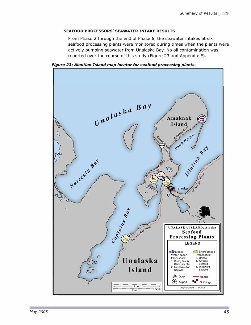
SEAFOOD PROCESSORS’ SEAWATER INTAKE RESULTS
From Phase 2 through the end of Phase 6, the seawater intakes at six seafood processing plants were monitored during times when the plants were actively pumping seawater from Unalaska Bay. No oil contamination was reported over the course of this study (Figure 23 and Appendix E).
Figure 23: Aleutian Island map locator for seafood processing plants.
Capt
ains B
ay Road
Bally
hoo
Ro
ad
E. Point Rd.
Airport Drive
Airp
ort B
each
Roa
d
Summ
er B
ay R
oad
Scale2 nm.
2 mi.
Ca
pt a
i ns
Ba
y
Na t e
e k i n B
a y
U n a l a s k a B a y
Il i
ul i
uk
Ba y D
utch H
arbor
Unalaska
Unalaska Is land
Amaknak Island
map updated: May 2005
LEGEND
4.
1.
3.2.
5.
Seafood Processing Plants
UNALASKA ISLAND, Alaska
Mobile Water-based Processors:1. Bering Star &
Discovery Star2. Royal Aleutian
Seafood
Shore-based Processors:3. Unisea4. Alyeska
Seafood5. Westward
Seafood
Dock
Airport
Roads
Buildings
46
M/V Selendang Ayu Oil Spill Fisheries Water Quality Sampling Program
May 2005
Scale
5 nm.5 mi.
5,000 yds.
Wide Bay
Nateekin Bay
Iliuliuk Bay
Capta
in’s
Bay
Summer Bay
Constantine Bay
Makushin Valley
Cape Cheerful
Priest Rock
Cape Kalekta
Unalaska Island
Version May 2005, Nuka Research Selendang Ayu Oil Spill Fisheries Water Quality Sampling Program
UNALASKA BAY ZONE
LEGEND
Passive Snare Device Results Phase 6
(3/05/05-3/24/05)
PSD Location - no oiling observed
PSD Location - oil smear observed
PSD Location - tarball observed
PSD Location - oil sheen observed on water
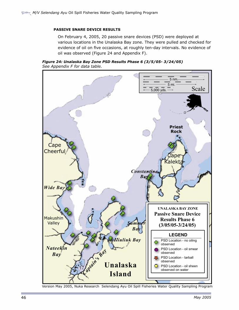
PASSIVE SNARE DEVICE RESULTS
On February 4, 2005, 20 passive snare devices (PSD) were deployed at various locations in the Unalaska Bay zone. They were pulled and checked for evidence of oil on five occasions, at roughly ten-day intervals. No evidence of oil was observed (Figure 24 and Appendix F).
Figure 24: Unalaska Bay Zone PSD Results Phase 6 (3/5/05- 3/24/05) See Appendix F for data table.
47
Summary of Results
May 2005
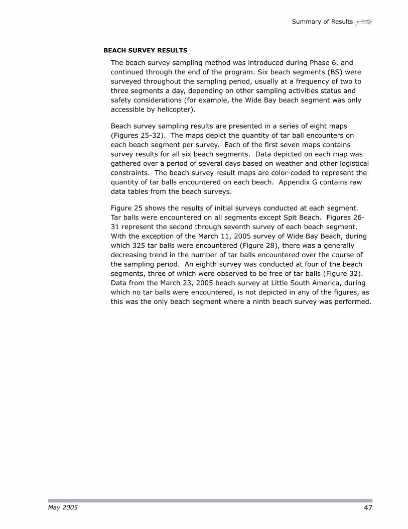
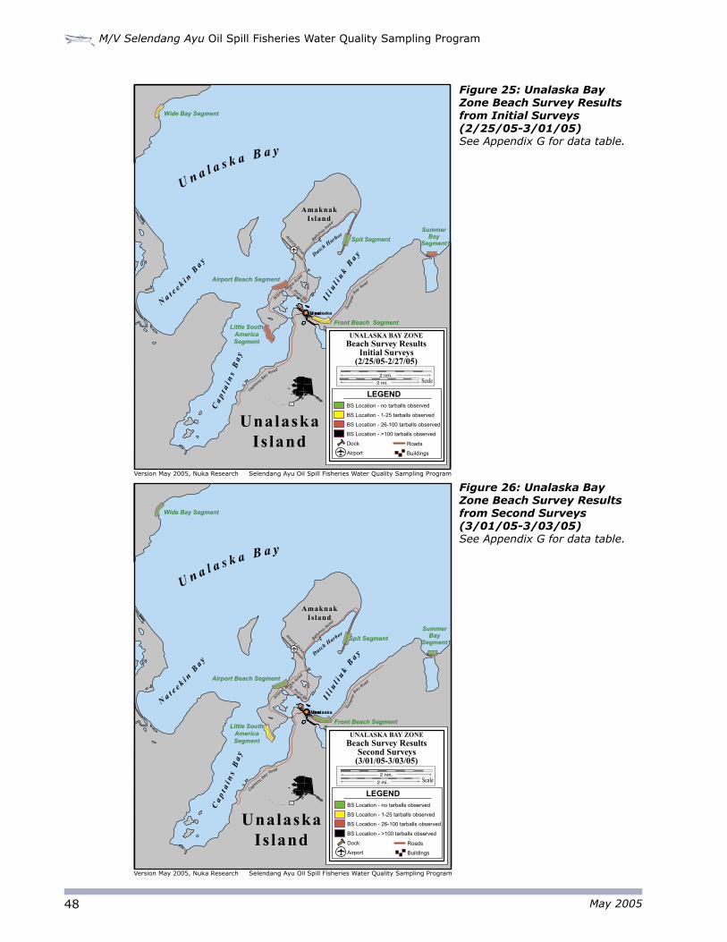
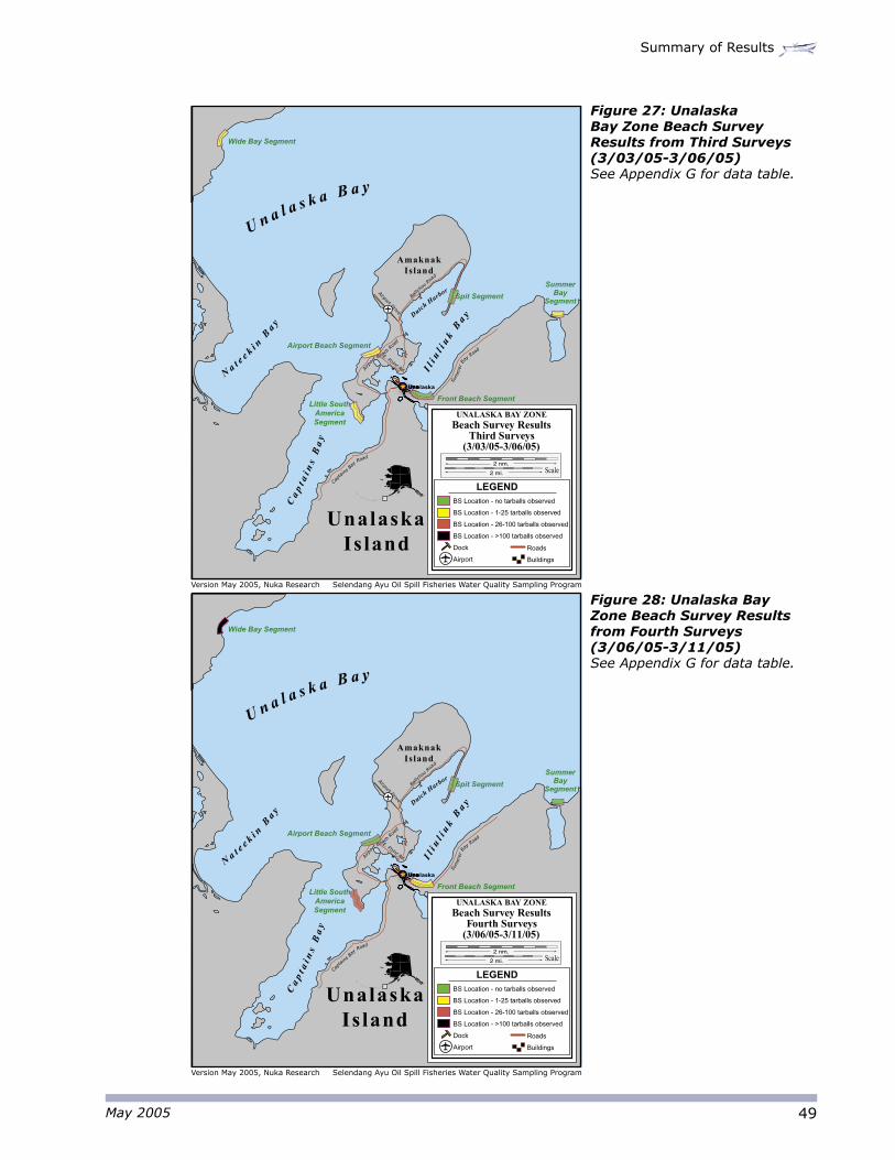
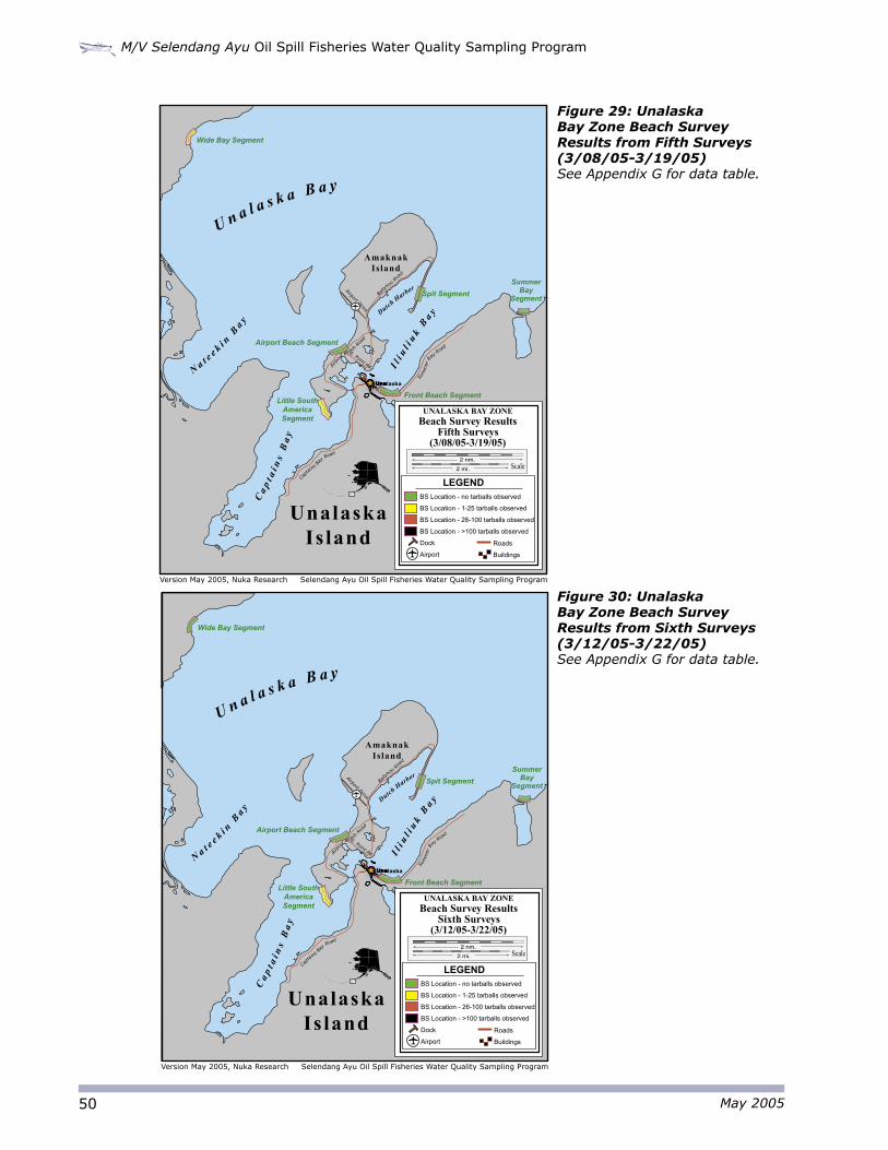
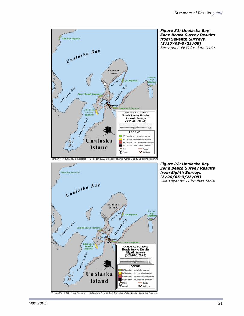
BEACH SURVEY RESULTS
The beach survey sampling method was introduced during Phase 6, and continued through the end of the program. Six beach segments (BS) were surveyed throughout the sampling period, usually at a frequency of two to three segments a day, depending on other sampling activities status and safety considerations (for example, the Wide Bay beach segment was only accessible by helicopter).
Beach survey sampling results are presented in a series of eight maps (Figures 25-32). The maps depict the quantity of tar ball encounters on each beach segment per survey. Each of the first seven maps contains survey results for all six beach segments. Data depicted on each map was gathered over a period of several days based on weather and other logistical constraints. The beach survey result maps are color-coded to represent the quantity of tar balls encountered on each beach. Appendix G contains raw data tables from the beach surveys.
Figure 25 shows the results of initial surveys conducted at each segment. Tar balls were encountered on all segments except Spit Beach. Figures 26-31 represent the second through seventh survey of each beach segment. With the exception of the March 11, 2005 survey of Wide Bay Beach, during which 325 tar balls were encountered (Figure 28), there was a generally decreasing trend in the number of tar balls encountered over the course of the sampling period. An eighth survey was conducted at four of the beach segments, three of which were observed to be free of tar balls (Figure 32). Data from the March 23, 2005 beach survey at Little South America, during which no tar balls were encountered, is not depicted in any of the figures, as this was the only beach segment where a ninth beach survey was performed.
48
M/V Selendang Ayu Oil Spill Fisheries Water Quality Sampling Program
May 2005
Figure 25: Unalaska Bay Zone Beach Survey Results from Initial Surveys (2/25/05-3/01/05) See Appendix G for data table.
Capt
ains B
ay Road
Bally
hoo
Ro
ad
E. Point Rd.
Airport Drive
Airp
ort B
each
Roa
d
Sum
mer
B
ay R
oad
Ca
pt a
i ns
Ba
y
Na t e
e k i n B
a y U n a l a s k a B a y
Il i
ul i
uk
Ba y D
utch Harbor
Unalaska
Unalaska Is land
Amaknak Island
Wide Bay Segment
Summer Bay
SegmentSpit Segment
Airport Beach Segment
Front Beach SegmentLittle South
America Segment
Version May 2005, Nuka Research Selendang Ayu Oil Spill Fisheries Water Quality Sampling Program
h
B
LEGENDBS Location - no tarballs observed
BS Location - 1-25 tarballs observed
BS Location - 26-100 tarballs observed
BS Location - >100 tarballs observed
Dock
Airport
Beach Survey ResultsInitial Surveys
(2/25/05-2/27/05)
UNALASKA BAY ZONE
Roads
Buildings
Scale2 nm.
2 mi.
Capt
ains B
ay Road
Bally
hoo
Ro
ad
E. Point Rd.
Airport Drive
Airp
ort B
each
Roa
d
Sum
mer
B
ay R
oad
Ca
pt a
i ns
Ba
y
Na t e
e k i n B
a y
U n a l a s k a B a y
Il i
ul i
uk
Ba y D
utch Harbor
Unalaska
Unalaska Is land
Amaknak Island
Wide Bay Segment
Summer Bay
SegmentSpit Segment
Airport Beach Segment
Front Beach SegmentLittle South
America Segment
Version May 2005, Nuka Research Selendang Ayu Oil Spill Fisheries Water Quality Sampling Program
h
B
SS
LEGENDBS Location - no tarballs observed
BS Location - 1-25 tarballs observed
BS Location - 26-100 tarballs observed
BS Location - >100 tarballs observed
Dock
Airport
Roads
Buildings
Beach Survey ResultsSecond Surveys
(3/01/05-3/03/05)
UNALASKA BAY ZONE
Scale2 nm.
2 mi.
Figure 26: Unalaska Bay Zone Beach Survey Results from Second Surveys (3/01/05-3/03/05) See Appendix G for data table.
49
Summary of Results
May 2005
Figure 27: Unalaska Bay Zone Beach Survey Results from Third Surveys (3/03/05-3/06/05) See Appendix G for data table.
Figure 28: Unalaska Bay Zone Beach Survey Results from Fourth Surveys (3/06/05-3/11/05) See Appendix G for data table.
Capt
ains B
ay Road
Bally
hoo
Ro
ad
E. Point Rd.
Airport Drive
Airp
ort B
each
Roa
d
Sum
mer
B
ay R
oad
Ca
pt a
i ns
Ba
y
Na t e
e k i n B
a y
U n a l a s k a B a y
Il i
ul i
uk
Ba y D
utch Harbor
Unalaska
Unalaska Is land
Amaknak Island
Wide Bay Segment
Summer Bay
SegmentSpit Segment
Airport Beach Segment
Front Beach SegmentLittle South
America Segment
h
B
SS
LEGENDBS Location - no tarballs observed
BS Location - 1-25 tarballs observed
BS Location - 26-100 tarballs observed
BS Location - >100 tarballs observed
Dock
Airport
Roads
Buildings
Beach Survey ResultsThird Surveys
(3/03/05-3/06/05)
UNALASKA BAY ZONE
Scale2 nm.
2 mi.
Version May 2005, Nuka Research Selendang Ayu Oil Spill Fisheries Water Quality Sampling Program
Capt
ains B
ay Road
Bally
hoo
Ro
ad
E. Point Rd.
Airport Drive
Airp
ort B
each
Roa
d
Sum
mer
B
ay R
oad
Ca
pt a
i ns
Ba
y
Na t e
e k i n B
a y
U n a l a s k a B a y
Il i
ul i
uk
Ba y D
utch Harbor
Unalaska
Unalaska Is land
Amaknak Island
Wide Bay Segment
Summer Bay
SegmentSpit Segment
Airport Beach Segment
Front Beach SegmentLittle South
America Segment
h
B
SS
LEGENDBS Location - no tarballs observed
BS Location - 1-25 tarballs observed
BS Location - 26-100 tarballs observed
BS Location - >100 tarballs observed
Dock
Airport
Roads
Buildings
Beach Survey ResultsFourth Surveys
(3/06/05-3/11/05)
UNALASKA BAY ZONE
Scale2 nm.
2 mi.
Version May 2005, Nuka Research Selendang Ayu Oil Spill Fisheries Water Quality Sampling Program
50
M/V Selendang Ayu Oil Spill Fisheries Water Quality Sampling Program
May 2005
Figure 29: Unalaska Bay Zone Beach Survey Results from Fifth Surveys (3/08/05-3/19/05) See Appendix G for data table.
Figure 30: Unalaska Bay Zone Beach Survey Results from Sixth Surveys (3/12/05-3/22/05) See Appendix G for data table.
Capt
ains B
ay Road
Bally
hoo
Ro
ad
E. Point Rd.
Airport Drive
Airp
ort B
each
Roa
d
Sum
mer
B
ay R
oad
Ca
pt a
i ns
Ba
y
Na t e
e k i n B
a y U n a l a s k a B a y
Il i
ul i
uk
Ba y D
utch Harbor
Unalaska
Unalaska Is land
Amaknak Island
Wide Bay Segment
Summer Bay
SegmentSpit Segment
Airport Beach Segment
Front Beach SegmentLittle South
America Segment
h
B
SS
LEGENDBS Location - no tarballs observed
BS Location - 1-25 tarballs observed
BS Location - 26-100 tarballs observed
BS Location - >100 tarballs observed
Dock
Airport
Roads
Buildings
Beach Survey ResultsFifth Surveys
(3/08/05-3/19/05)
UNALASKA BAY ZONE
Scale2 nm.
2 mi.
Version May 2005, Nuka Research Selendang Ayu Oil Spill Fisheries Water Quality Sampling Program
Capt
ains B
ay Road
Bally
hoo
Ro
ad
E. Point Rd.
Airport Drive
Airp
ort B
each
Roa
d
Sum
mer
B
ay R
oad
Ca
pt a
i ns
Ba
y
Na t e
e k i n B
a y
U n a l a s k a B a y
Il i
ul i
uk
Ba y D
utch Harbor
Unalaska
Unalaska Is land
Amaknak Island
Wide Bay Segment
Summer Bay
SegmentSpit Segment
Airport Beach Segment
Front Beach SegmentLittle South
America Segment
h
B
LEGENDBS Location - no tarballs observed
BS Location - 1-25 tarballs observed
BS Location - 26-100 tarballs observed
BS Location - >100 tarballs observed
Dock
Airport
Roads
Buildings
Beach Survey ResultsSixth Surveys
(3/12/05-3/22/05)
UNALASKA BAY ZONE
Scale2 nm.
2 mi.
Version May 2005, Nuka Research Selendang Ayu Oil Spill Fisheries Water Quality Sampling Program
51
Summary of Results
May 2005
Figure 31: Unalaska Bay Zone Beach Survey Results from Seventh Surveys (3/17/05-3/21/05) See Appendix G for data table.
Figure 32: Unalaska Bay Zone Beach Survey Results from Eighth Surveys (3/20/05-3/23/05) See Appendix G for data table.
Capt
ains B
ay Road
Bally
hoo
Ro
ad
E. Point Rd.
Airport Drive
Airp
ort B
each
Roa
d
Sum
mer
B
ay R
oad
Ca
pt a
i ns
Ba
y
Na t e
e k i n B
a y
U n a l a s k a B a y
Il i
ul i
uk
Ba y D
utch Harbor
Unalaska
Unalaska Is land
Amaknak Island
Wide Bay Segment
Summer Bay
SegmentSpit Segment
Airport Beach Segment
Front Beach SegmentLittle South
America Segment
h
B
LEGENDBS Location - no tarballs observed
BS Location - 1-25 tarballs observed
BS Location - 26-100 tarballs observed
BS Location - >100 tarballs observed
Dock
Airport
Roads
Buildings
Beach Survey ResultsEighth Surveys
(3/20/05-3/23/05)
UNALASKA BAY ZONE
Scale2 nm.
2 mi.
Version May 2005, Nuka Research Selendang Ayu Oil Spill Fisheries Water Quality Sampling Program
Capt
ains B
ay Road
Bally
hoo
Ro
ad
E. Point Rd.
Airport Drive
Airp
ort B
each
Roa
d
Sum
mer
B
ay R
oad
Ca
pt a
i ns
Ba
y
Na t e
e k i n B
a y
U n a l a s k a B a y
Il i
ul i
uk
Ba y D
utch Harbor
Unalaska
Unalaska Is land
Amaknak Island
Wide Bay Segment
Summer Bay
SegmentSpit Segment
Airport Beach Segment
Front Beach SegmentLittle South
America Segment
h
B
LEGENDBS Location - no tarballs observed
BS Location - 1-25 tarballs observed
BS Location - 26-100 tarballs observed
BS Location - >100 tarballs observed
Dock
Airport
Roads
Buildings
Beach Survey ResultsSeventh Surveys (3/17/05-3/21/05)
UNALASKA BAY ZONE
Scale2 nm.
2 mi.
Version May 2005, Nuka Research Selendang Ayu Oil Spill Fisheries Water Quality Sampling Program