summary of technical analysis - new jersey · new jersey department of transportation report to the...
TRANSCRIPT

REPORT TO THE GOVERNOR AND LEGISLATURE
June 2014
Study of Stormwater Basinsin the Barnegat Bay Watershed
new jerseydepartment of transportation
SUMMARY OF TECHNICAL ANALYSISAS MANDATED BY P.L. 2010, CHAPTER 114

NEW JERSEY DEPARTMENT OF TRANSPORTATION
REPORT TO THE GOVERNOR AND LEGISLATURE
Study of Stormwater Basins
in the Barnegat Bay Watershed
Summary of Technical Analysis AS AUTHORIZED BY P.L. 2010, CHAPTER 114
June 2014

Study of Stormwater Basins in the Barnegat Bay Watershed Summary of Technical Analysis
Table of Contents
1. Purpose of Study ......................................................................................................... 1
2. Assessment of Condition ............................................................................................ 1
Inventory of Basins ....................................................................................................... 2
Type and Function ........................................................................................................ 2
Required Remediation ............................................................................................... 11
3. Findings ..................................................................................................................... 19
4. Recommendations .................................................................................................... 20
Appendices
Appendix 1 P.L. 2010, Chapter 114
Appendix 2 Location Map
Glossary
i

List of Figures
Figure 1 – Plan view of typical constructed wetland basin design ............................................ 3
Figure 2 – Plan view and cross section of typical extended detention basin design ................ 4
Figure 3 – Plan view and cross section of typical infiltration basin design ................................5
Figure 4 – Plan view of typical wet pond basin design ............................................................ 6
List of Tables
Table 1 – Location of Inventoried Stormwater Basins ............................................................ 2
Table 2 – Inventoried Stormwater Basins by Type .................................................................. 2
Table 3 – Inventory of Basins ................................................................................................... 7
Table 4 – Inventoried Stormwater Basin by Need for Remediation ....................................... 12
Table 5 – Basin Maintenance Needs ...................................................................................... 13
Table 6 – Basin Maintenance Needs Summary ...................................................................... 19
Table 7 – Basins in Urgent Need of Maintenance .................................................................. 20
Table 8 – Basins in Elevated Need of Maintenance ................................................................ 21
ii
Study of Stormwater Basins in the Barnegat Bay Watershed 1
1. Purpose of Study
In January 2011, Governor Christie signed into law Bill A-3606, which requires the New Jersey
Department of Transportation (NJDOT) to inventory and assess state-owned stormwater
basins in the Barnegat Bay Watershed.
Known as Public Law 2010, Chapter 114 (P.L. 2010, c. 114), the Act specifically requires the
NJDOT, in consultation with the Department of Treasury, to conduct a study of all state
stormwater basins located in the Barnegat Bay Watershed to identify those that are
malfunctioning. NJDOT is further directed to submit to the Governor and the Legislature a list
of the malfunctioning basins prioritized to indicate the order in which they should be repaired
and the estimated cost for each repair. In addition, the Act requires NJDOT, the New Jersey Transit Corporation (Transit) and the New
Jersey Turnpike Authority (NJTA) to include the repair of malfunctioning stormwater basins
identified in the report in their annual plans for capital projects based upon the priority order
outlined in the study. The full text of the Act can be found in Appendix 1.
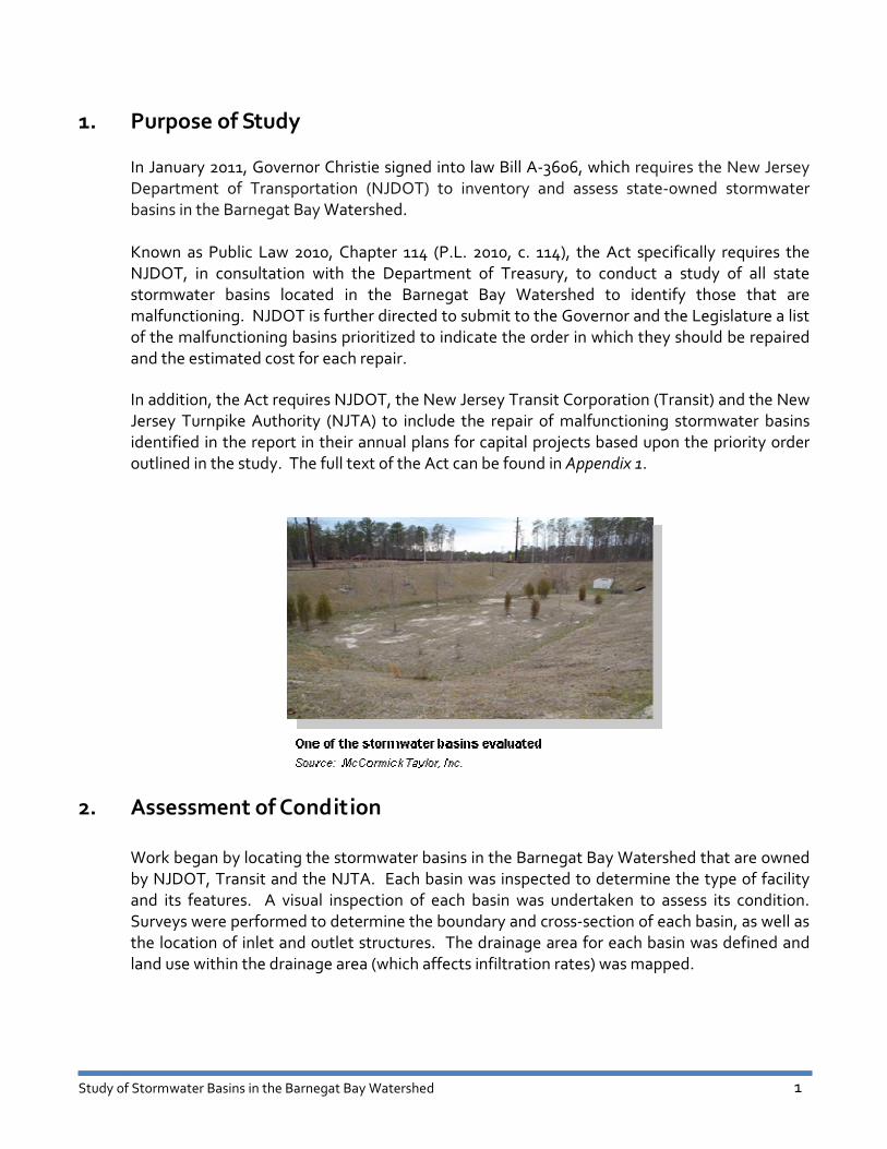
2. Assessment of Condition
Work began by locating the stormwater basins in the Barnegat Bay Watershed that are owned
by NJDOT, Transit and the NJTA. Each basin was inspected to determine the type of facility
and its features. A visual inspection of each basin was undertaken to assess its condition.
Surveys were performed to determine the boundary and cross-section of each basin, as well as
the location of inlet and outlet structures. The drainage area for each basin was defined and
land use within the drainage area (which affects infiltration rates) was mapped.

Study of Stormwater Basins in the Barnegat Bay Watershed 2
Inventory of Basins
One hundred twenty-five (125) stormwater basins have been inventoried and mapped. Of
these, one is owned by Transit, thirty (30) are owned by the NJTA and ninety-four (94) are
owned by the NJDOT. The basins are located along seven principal highways and at a rail yard:
Table 1 – Location of Inventoried Stormwater Basins
Location Number of Basins
Bay Head Rail Yard 1
Garden State Parkway 30
I-195 11
NJ Route 37 14
NJ Route 70 63
NJ Route 72 4
NJ Route 88 1
U.S. 9 1
The locations of these basins are shown on the Location Map found in Appendix 2.
Type and Function
As defined in the New Jersey Stormwater Best Management Practices Manual, there are four
general types of state-owned stormwater basins in the Barnegat Bay Watershed:
Table 2 – Inventoried Stormwater Basins by Type
Type Number of Basins
Constructed Wetland Basins 4
Extended Detention Basins 68
Infiltration Basins 50
Wet Pond Basins 3

Study of Stormwater Basins in the Barnegat Bay Watershed 3
Constructed wetland basins temporarily store stormwater runoff within an area of wetland
vegetation and slowly release it to downstream drainage systems through an outlet control
structure. Such basins have been constructed to mitigate the loss of natural wetland areas
disturbed by highway project construction. During dry weather, a constructed wetland
typically retains a series of small pools.
Figure 1 – Plan view of typical constructed wetland basin design
Source: VA DCR Stormwater Design Specification No. 13, January 1, 2013, pg.3.

Study of Stormwater Basins in the Barnegat Bay Watershed 4
Extended detention basins temporarily store stormwater runoff above the ground surface
during precipitation events and slowly release it to downstream drainage systems through an
outlet control structure. During dry weather, an extended detention basin should be empty.
Figure 2 – Plan view and cross section of typical extended detention basin design
Source: New Jersey Stormwater Best Management Practices Manual, Chapter 9.4: Standard for Extended Detention Basins, February 2004, Page 9.4-2.

Study of Stormwater Basins in the Barnegat Bay Watershed 5
Infiltration basins temporarily store stormwater runoff above the ground surface during
precipitation events and slowly infiltrate it into the ground below the basin. During dry
weather, an infiltration basin should be empty.
Figure 3 – Plan view and cross section of typical infiltration basin design
Source: New Jersey Stormwater Best Management Practices Manual, Chapter 9.5: Standard for Infiltration Basins, February 2004, Page 9.5-5.

Study of Stormwater Basins in the Barnegat Bay Watershed 6
Wet Pond Basins temporarily store stormwater runoff above a permanent pool during
precipitation events and slowly release it to downstream drainage systems through an outlet
control structure. During dry weather, a wet pond retains its permanent pool.
Table 3 lists the inventoried basins by roadway location and type.
The basins studied have widely varying capacities. The smaller basins only have the capacity to
accommodate the annual or 1-year storm event, while the largest capacity basins are able to
accommodate a 25-year storm.
Figure 4 – Plan view of typical wet pond basin design
Source: New Jersey Stormwater Best Management Practices Manual • Chapter 9.2: Standard for Constructed Stormwater Wetlands, February 2004, Page 9.2-4.

Study of Stormwater Basins in the Barnegat Bay Watershed 7
Table 3 – Inventory of Basins
Bay Head Rail Yard Stormwater Management Basin
No. Basin ID Nearest Intersection Location Basin Type
1 BHRY Infield Constructed Wetland
Garden State Parkway Stormwater Management Basins
No. Basin ID Nearest Intersection Location Basin Type
1 GSP – NB – 64.11 Route 72 Infield Infiltration
2 GSP – SB – 64.11 #1 Route 72 Infield Infiltration
3 GSP – SB – 64.11 #2 Route 72 Infield Infiltration
4 GSP – SB – 64.11 #3 Route 72 Infield Infiltration
5 GSP – SB – 64.11 #4 Route 72 Infield Infiltration
6 GSP – SB – 64.11 #5 Route 72 Infield Infiltration
7 GSP – NB – 66.20 Bay Avenue Infield Infiltration
8 GSP – NB – 67.81 #1 Bay Avenue Infield Extended Detention
9 GSP – NB – 67.81 #2 Bay Avenue Infield Extended Detention
10 GSP – NB – 67.81 #3 Bay Avenue Infield Extended Detention
11 GSP – NB – 67.81 #4 Bay Avenue Infield Extended Detention
12 GSP – SB – 67.81 #1 Bay Avenue Infield Infiltration
13 GSP – SB – 67.81 #3 Bay Avenue Infield Extended Detention
14 GSP – NB – 70.45 #1 Wells Mill Road Infield Extended Detention
15 GSP – NB – 70.45 #2 Wells Mill Road Infield Infiltration
16 GSP – SB – 70.45 #1 Wells Mill Road Infield Infiltration
17 GSP – SB – 70.45 #2 Wells Mill Road Infield Infiltration
18 GSP – SB – 75.34 Lacey Road Infield Infiltration
19 GSP – NB/SB – 76.10 Forked River Srvc Plza Service Plaza Infiltration
20 GSP – NB – 77.40 #1 Forest Hills Parkway Infield Infiltration
21 GSP – NB – 77.40 #2 Forest Hills Parkway Infield Infiltration
22 GSP – SB – 78.30 #1 Double Trouble Road Infield Infiltration
23 GSP – SB – 78.30 #2 Double Trouble Road Infield Infiltration
24 GSP – NB – 80.20 Birch Street Roadside Extended Detention
25 GSP – SB – 80.94 U.S. 9 – Exit 80 Infield Extended Detention
26 GSP – NB – 90.18 #3 Cedar Bridge Avenue Infield Extended Detention
27 GSP – NB – 90.18 #4 Cedar Bridge Avenue Infield Extended Detention
28 GSP – SB – 90.18 #1 Cedar Bridge Avenue Infield Extended Detention
29 GSP – SB – 90.18 #2 Cedar Bridge Avenue Infield Extended Detention
30 GSP – NB – 92.62 Burnt Tavern Road Roadside Extended Detention

Study of Stormwater Basins in the Barnegat Bay Watershed 8
Table 3 – Inventory of Basins (Continued)
I-195 Stormwater Management Basins
No. Basin ID Nearest Intersection Location Basin Type
1 I-195 – EB – 16.71 #1 Monmouth Road Infield Extended Detention
2 I-195 – EB – 16.71 #2 Monmouth Road Infield Infiltration
3 I-195 – EB – 16.71 #3 Monmouth Road Infield Infiltration
4 I-195 – EB – 21.04 #1 Cedar Swamp Road Infield Extended Detention
5 I-195 – EB – 21.04 #2 Cedar Swamp Road Infield Extended Detention
6 I-195 – EB – 21.04 #3 Cedar Swamp Road Infield Extended Detention
7 I-195 – WB – 21.04 Cedar Swamp Road Infield Extended Detention
8 I-195 – WB – 22.99 #1 County Road 638 Infield Extended Detention
9 I-195 – WB – 22.99 #2 County Road 638 Infield Extended Detention
10 I-195 – EB – 27.17 #1 U.S. 9 Infield Extended Detention
11 I-195 – EB – 27.17 #2 U.S. 9 Infield Extended Detention
NJ Route 37 Stormwater Management Basins
No. Basin ID Nearest Intersection Location Basin Type
1 37 – EB – 0.61 Colonial Drive Infield Infiltration
2 37 – EB – 1.10 Bone Hill Road Infield Wet Pond
3 37 – WB – 1.10 Buckingham Drive Infield Infiltration
4 37 – EB – 1.77 Commonwealth Blvd. Infield Extended Detention
5 37 – EB – 2.57 Northhampton Road Infield Infiltration
6 37 – WB – 2.57 Northhampton Road Infield Infiltration
7 37 – WB – 3.11 Bimini Drive Infield Extended Detention
8 37 – EB – 3.47 St. Catherine Blvd. Infield Wet Pond
9 37 – WB – 3.47 St. Catherine Blvd. Infield Wet Pond
10 37 – EB – 4.02 Bananier Drive Infield Infiltration
11 37 – WB – 4.02 Romana Lane Infield Infiltration
12 37 – EB – 4.34 Germania Street Behind BJ’s Extended Detention
13 37 – EB – 4.54 Mule Road Infield Extended Detention
14 37 – WB – 5.76 Hospital Drive Infield Extended Detention
NJ Route 70 Stormwater Management Basins
No. Basin ID Nearest Intersection Location Basin Type
1 70 – WB – 45.44 Colonial Drive Roadside Infiltration
2 70 – EB – 48.40 Kettle Creek Road Roadside Infiltration
3 70 – WB – 48.62 Whitesville Road Roadside Infiltration
4 70 – WB – 48.80 Yale Avenue Roadside Infiltration
5 70 – WB – 48.85 Yale Avenue Roadside Infiltration
6 70 – EB – 48.90 Trailer Park Roadside Infiltration
7 70 – EB – 48.95 Trailer Park Roadside Infiltration
8 70 – WB – 49.02 Private Road Roadside Extended Detention

Study of Stormwater Basins in the Barnegat Bay Watershed 9
Table 3 – Inventory of Basins (Continued)
NJ Route 70 Stormwater Management Basins (Continued)
No. Basin ID Nearest Intersection Location Basin Type
9 70 – EB – 49.27 Massachusetts Ave. Roadside Extended Detention
10 70 – WB – 49.27 Massachusetts Ave. Roadside Infiltration
11 70 – EB – 49.30 Massachusetts Ave. Roadside Infiltration
12 70 – WB – 49.30 Massachusetts Ave. Roadside Infiltration
13 70 – EB – 49.90 U.S. 9 Infield Extended Detention
14 70 – EB – 50.55 Vermont Avenue Roadside Infiltration
15 70 – WB – 50.57 Vermont Avenue Infield Extended Detention
16 70 – WB – 51.25 New Hampshire Ave. Infield Extended Detention
17 70 – WB – 51.26 New Hampshire Ave. Infield Constructed Wetland
18 70 – WB – 51.27 New Hampshire Ave. Roadside Constructed Wetland
19 70 – EB – 51.70 Towbin Avenue Infield Constructed Wetland
20 70 – WB – 51.75 Towbin Avenue Roadside Infiltration
21 70 – EB – 52.62 Ramp to GSP Infield Infiltration
22 70 – EB – 53.19 Shorrock Street Infield Infiltration
23 70 – EB – 53.46 Shopping Center Infield Extended Detention
24 70 – WB – 53.46 Shopping Center Infield Extended Detention
25 70 – EB – 53.47 Shopping Center Roadside Extended Detention
26 70 – WB – 53.79 Shopping Center Roadside Extended Detention
27 70 – WB – 53.93 Cedar Bridge Road Roadside Infiltration
28 70 – WB – 54.02 Cedar Bridge Road Roadside Extended Detention
29 70 – WB – 54.03 #1 Cedar Bridge Road Infield Infiltration
30 70 – WB – 54.03 #2 Cedar Bridge Road Infield Infiltration
31 70 – WB – 54.04 Cedar Bridge Road Infield Infiltration
32 70 – WB – 55.69 Jack Martin Ramp Roadside Extended Detention
33 70 – WB – 55.71 Jack Martin Blvd. Infield Extended Detention
34 70 – EB – 56.07 Van Zile Road Roadside Infiltration
35 70 – EB – 56.08 Van Zile Road Roadside Extended Detention
36 70 – WB – 56.08 Van Zile Road Roadside Extended Detention
37 70 – EB – 56.10 Van Zile Road Infield Extended Detention
38 70 – WB – 56.10 Van Zile Road Infield Extended Detention
39 70 – EB – 56.11 Van Zile Road Roadside Extended Detention
40 70 – WB – 56.12 Van Zile Road Roadside Extended Detention
41 70 – EB – 56.15 Kentwood Boulevard Roadside Extended Detention
42 70 – WB – 56.27 Before Pello Road Roadside Extended Detention
43 70 – WB – 56.33 Industrial Way Roadside Extended Detention
44 70 – EB – 56.70 Morris Avenue Infield Extended Detention
45 70 – WB – 56.71 Morris Avenue Roadside Extended Detention
46 70 – EB – 56.72 Morris Avenue Infield Extended Detention
47 70 – WB – 56.72 Morris Avenue Infield Extended Detention
48 70 – WB – 56.85 Ramp to Morris Ave. Roadside Extended Detention

Study of Stormwater Basins in the Barnegat Bay Watershed 10
Table 3 – Inventory of Basins (Continued)
NJ Route 70 Stormwater Management Basins (Continued)
No. Basin ID Nearest Intersection Location Basin Type
49 70 – EB – 56.95 MacArthur Drive Roadside Extended Detention
50 70 – WB – 56.95 Westwood Place Roadside Extended Detention
51 70 – EB – 57.18 Burnt Tavern Road Roadside Infiltration
52 70 – EB – 57.19 Burnt Tavern Road Infield Infiltration
53 70 – WB – 57.19 Chestnut Drive Roadside Extended Detention
54 70 – WB – 57.22 Ramp to Chestnut Dr. Infield Extended Detention
55 70 – WB – 57.49 Chestnut Drive Roadside Extended Detention
56 70 – WB – 57.50 Chestnut Drive Roadside Extended Detention
57 70 – WB – 57.72 Herbertsville Road Infield Extended Detention
58 70 – WB – 57.73 #1 Herbertsville Road Infield Extended Detention
59 70 – WB – 57.73 #2 Herbertsville Road Infield Extended Detention
60 70 – EB – 57.90 Herbertsville Road Roadside Extended Detention
61 70 – WB – 57.90 Herbertsville Road Roadside Extended Detention
62 70 – EB – 58.11 River Road Infield Infiltration
63 70 – WB – 58.11 Riviera Drive Infield Infiltration
NJ Route 72 Stormwater Management Basins
No. Basin ID Nearest Intersection Location Basin Type
1 72 – EB – 21.00 Nautilus Drive Infield Infiltration
2 72 – EB – 21.37 Stafford Park Roadside Extended Detention
3 72 – EB – 21.44 Stafford Park Roadside Extended Detention
4 72 – EB – 21.45 Stafford Park Infield Extended Detention
Route 88 Stormwater Management Basin
No. Basin ID Nearest Intersection Location Basin Type
1 88 – WB – 8.88 Herbertsville Road
(Beaver Dam Drive) Infield Extended Detention
U.S. 9 Stormwater Management Basin
No. Basin ID Nearest Intersection Location Basin Type
1 9 – SB – 91.05 GSP Infield Infiltration
The intent of this study was to identify “malfunctioning” state-owned stormwater basins in the
Barnegat Bay Watershed. To assess malfunctioning basins, the study first identified issues
affecting basin performance that can be remediated through repairs or maintenance.

Study of Stormwater Basins in the Barnegat Bay Watershed 11
Required Remediation
Stormwater basins can experience operational problems due to a need for maintenance.
Inflow measures and 0utlet control structures can deteriorate or be damaged and can become
obstructed by runoff-borne sediment, vegetation and debris. Infiltration basin bottoms can
become compacted or sealed by this same sediment and debris. This can result in a
malfunctioning basin, which can lead to excessive outflows and downstream flooding or
erosion.
All stormwater basins require at least regular maintenance. The degree of corrective or
remedial maintenance needed depends upon the basin design, the quality of construction, and
the frequency and extent of past maintenance efforts.
Operational and remedial maintenance needs were identified for each basin during field
inspections. A host of solutions were also identified:
General Maintenance
� Remove trash and leaf litter from basin bottom and side slopes
� Remove trash and leaf litter from inflow pipes and outlet structure
� Remove sediment from basin bottom and clogged pipes
� Remove overgrown vegetation, including tree stumps
� Restore eroded side slopes
� Restore grass on basin bottom and side slopes
� Clean and restore low flow channel
� Scarify sand bottom of basin
� Replace rip rap apron
� Repair concrete head wall
� Repair concrete outlet structure
� Repair broken trash rack
� Replace broken pipe or end section
Safety
� Repair chain link fence
� Repair gate
� Provide gate lock
Clogged inlet pipe in urgent need of maintenance
Source: McCormick Taylor, Inc.

Study of Stormwater Basins in the Barnegat Bay Watershed 12
Based on field conditions, basins were placed into one of three categories of remediation:
Table 4 – Inventoried Stormwater Basins
by Need for Remediation
Category of Need Number of Basins
Urgent Need 14
Elevated Need 23
Routine Need 88
� Urgent Need – Deficiencies that require immediate attention (e.g., sediment
blockage of pipes of over 70%, collapsed pipes, broken outlet structures,
sinkholes, severe erosion of embankments) or any other problem that would
impair the ability of the basin to properly function.
� Elevated Need – Deficiencies that are recommended for repair or modification in
the near future, such as retrofitting or modifying the outlet structure. Basins were
also placed in this category if there was sediment blockage of pipes between 30%
and 70%, or if basin side slopes were eroded.
� Routine Need – Deficiencies that can be repaired by maintenance staff using
agency owned equipment and materials, or by using an annual maintenance
contract. This category encompasses routine maintenance and repair work, such
as removing silt (sediment blockage of pipes less than 30%), trash or debris, or
cutting the grass.
This study has determined that 30% or thirty-seven (37) of the 125 stormwater basins
evaluated are deemed to be in need of either an urgent or elevated level of remedial
maintenance. The maintenance needs of basins are shown in Table 5.
The required maintenance costs are based upon prior experience with state highway basins.
Previous work includes cleaning, sediment removal, clearing of blocked pipes, tree removal
and vegetation clearing. Cost estimates include equipment, manpower and disposal expenses.

Study of Stormwater Basins in the Barnegat Bay Watershed 13
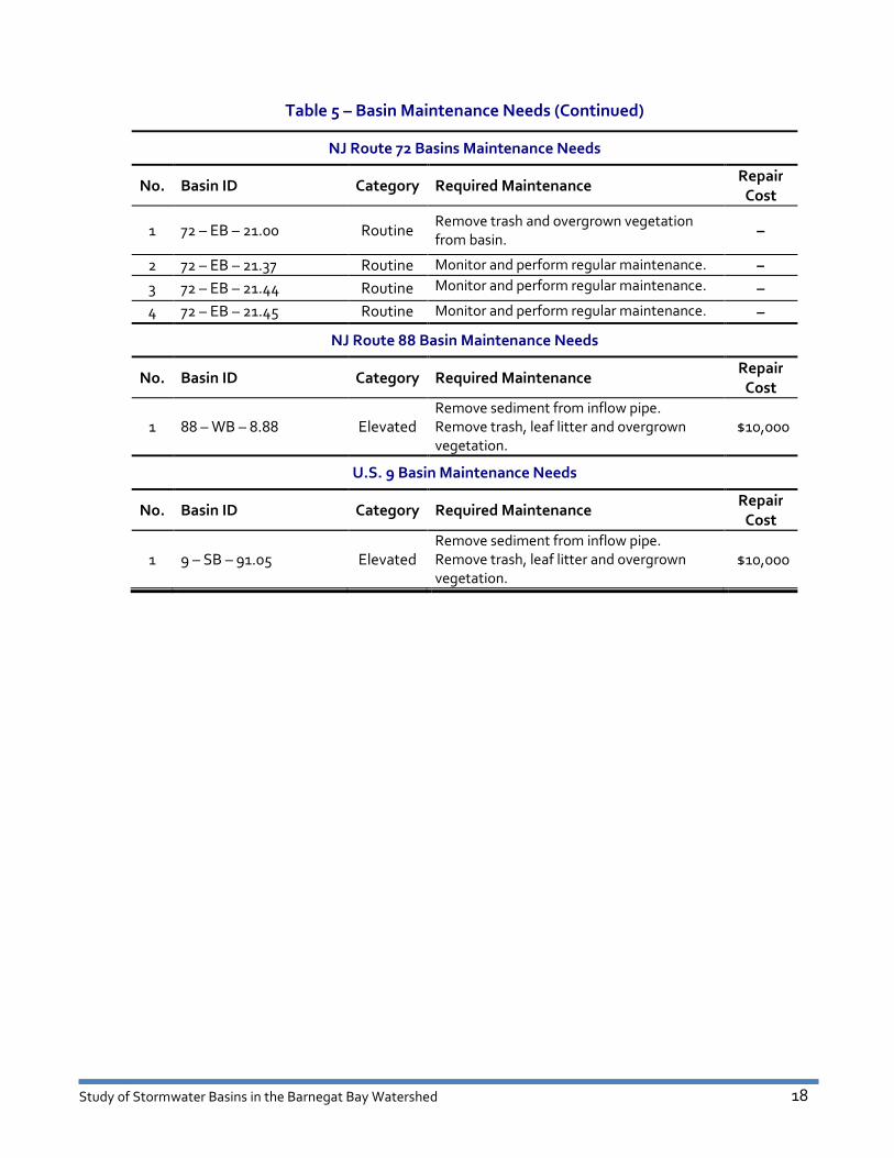
Table 5 – Basin Maintenance Needs
Bay Head Rail Yard Basin Maintenance Needs
No. Basin ID Category Required Maintenance Repair
Cost
1 BHRY Routine Monitor and perform regular maintenance. –
Garden State Parkway Basins Maintenance Needs
No. Basin ID Category Required Maintenance Repair
Cost
1 GSP – NB – 90.18 #3 Urgent Remove sediment from pipes. Remove
overgrown vegetation and trash from basin. $10,000
2 GSP – SB – 90.18 #1 Urgent Remove sediment from pipes. Remove
overgrown vegetation and trash from basin. $10,000
3 GSP – NB – 64.11 Elevated Remove sediment from pipes. Remove
overgrown vegetation and trash from basin. $10,000
4 GSP – NB – 70.45 #1 Elevated Remove sediment from pipes. Remove
overgrown vegetation and trash from basin. $10,000
5 GSP – SB – 70.45 #1 Elevated Remove sediment from pipes. Remove
overgrown vegetation and trash from basin. $10,000
6 GSP – SB – 75.34 Elevated Remove sediment from pipes. Remove trash
from basin. $5,000
7 GSP – NB – 77.40 #2 Elevated Remove sediment from pipes. Remove trash
from basin. $5,000
8 GSP – SB – 90.18 #2 Elevated Restore eroded basin side slopes. $10,000
9 GSP – NB – 90.18 #4 Elevated Restore eroded basin side slopes. Remove
trash from basin. $10,000
10 GSP – SB – 64.11 #1 Routine Monitor and perform regular maintenance. –
11 GSP – SB – 64.11 #2 Routine Monitor and perform regular maintenance. –
12 GSP – SB – 64.11 #3 Routine Monitor and perform regular maintenance. –
13 GSP – SB – 64.11 #4 Routine Monitor and perform regular maintenance. –
14 GSP – SB – 64.11 #5 Routine Monitor and perform regular maintenance. –
15 GSP – NB – 66.20 Routine Monitor and perform regular maintenance. –
16 GSP – NB – 67.81 #1 Routine Monitor and perform regular maintenance. –
17 GSP – NB – 67.81 #2 Routine Monitor and perform regular maintenance. –
18 GSP – NB – 67.81 #3 Routine Monitor and perform regular maintenance. –
19 GSP – NB – 67.81 #4 Routine Monitor and perform regular maintenance. –
20 GSP – SB – 67.81 #1 Routine Monitor and perform regular maintenance. –
21 GSP – SB – 67.81 #3 Routine Monitor and perform regular maintenance. –
22 GSP – NB – 70.45 #2 Routine Monitor and perform regular maintenance. –
23 GSP – SB – 70.45 #2 Routine Monitor and perform regular maintenance. –
24 GSP – NB/SB – 76.10 Routine Monitor and perform regular maintenance. –
25 GSP – NB – 77.40 #1 Routine Monitor and perform regular maintenance. –
26 GSP – SB – 78.30 #1 Routine Monitor and perform regular maintenance. –
27 GSP – SB – 78.30 #2 Routine Monitor and perform regular maintenance. –

Study of Stormwater Basins in the Barnegat Bay Watershed 14
Table 5 – Basin Maintenance Needs (Continued)
Garden State Parkway Basins Maintenance Needs (Continued)
No. Basin ID Category Required Maintenance Repair
Cost
28 GSP – NB – 80.20 Routine Monitor and perform regular maintenance. –
29 GSP – SB – 80.94 Routine Monitor and perform regular maintenance. –
30 GSP – NB – 92.62 Routine Monitor and perform regular maintenance. –
I-195 Basins Maintenance Needs
No. Basin ID Category Required Maintenance Repair
Cost
1 I-195 – WB – 21.04 Urgent Remove sediment from all pipes. Remove
trash and leaf litter. $10,000
2 I-195 – EB – 16.71 #3 Elevated Remove leaf litter. Restore eroded basin side
slope near inflow pipe and re-establish
ground cover. Install rip rap at inflow pipe. $15,000
3 I-195 – EB – 21.04 #1 Elevated Remove trash and leaf litter. Remove
sediment from all pipes. $6,000
4 I-195 – WB – 22.99 #1 Routine Remove trash, leaf litter and dead branches
from basin. –
5 I-195 – EB – 27.17 #2 Routine Remove trash and debris from basin. –
6 I-195 – EB – 16.71 #1 Routine Monitor and perform regular maintenance. –
7 I-195 – EB – 16.71 #2 Routine Monitor and perform regular maintenance. –
8 I-195 – EB – 21.04 #2 Routine Monitor and perform regular maintenance. –
9 I-195 – EB – 21.04 #3 Routine Monitor and perform regular maintenance. –
10 I-195 – WB – 22.99 #2 Routine Monitor and perform regular maintenance. –
11 I-195 – EB – 27.17 #1 Routine Monitor and perform regular maintenance. –
NJ Route 37 Basins Maintenance Needs
No. Basin ID Category Required Maintenance Repair
Cost
1 37 – EB – 1.10 Urgent Remove sediment from bottom and inflow
pipe. Remove overgrown vegetation. $10,000
2 37 – WB – 1.10 Urgent Remove overgrown vegetation from inflow
and outflow pipes. Remove trash from basin
bottom.
$10,000
3 37 – EB – 2.57 Urgent Remove sediment from bottom and inflow
pipe. Remove overgrown vegetation. $10,000
4 37 – WB – 2.57 Urgent Remove sediment from bottom and inflow
pipe. Remove overgrown vegetation. $10,000
5 37 – EB – 3.47 Urgent Clean inflow and outflow pipes. Remove
overgrown vegetation, including tree stump. $10,000
6 37 – WB – 3.47 Urgent Clean inflow and outflow pipes. Remove
overgrown vegetation, including tree stump. $10,000

Study of Stormwater Basins in the Barnegat Bay Watershed 15
Table 5 – Basin Maintenance Needs (Continued)
NJ Route 37 Basins Maintenance Needs (Continued)
No. Basin ID Category Required Maintenance Repair
Cost
7 37 – EB – 4.02 Urgent Remove sediment from inflow pipes. Repair
outlet structure trash rack. Remove
overgrown vegetation and cut trees.
$15,000
8 37 – WB – 4.02 Urgent Remove sediment from pipes. Replace
broken pipe section. Remove leaf, trash and
overgrown vegetation. $25,000
9 37 – EB – 4.54 Urgent Clean pipes. Remove trash and debris from
basin and outlet structure. $10,000
10 37 – WB – 5.76 Urgent Clean pipes. Remove trash and debris from
basin and outlet structure. $10,000
11 37 – WB – 3.11 Elevated Replace broken inflow pipes. Remove
sediment, trash and overgrown vegetation.
Restore eroded side slope. $25,000
12 37 – EB – 0.61 Routine Remove leaf litter and overgrown
vegetation. Remove sediment from inflow
pipe.
–
13 37 – EB – 1.77 Routine Remove trash and sediment from pipes.
Remove overgrown vegetation. –
14 37 – EB – 4.34 Routine Remove trash, sediment and overgrown
vegetation. –
NJ Route 70 Basins Maintenance Needs
No. Basin ID Category Required Maintenance Repair
Cost
1 70 – EB – 53.19 Urgent Remove sediment from inflow pipes.
Remove overgrown vegetation and trash. $10,000
2 70 – WB – 45.44 Elevated Remove sediment and leaf litter from inflow
pipe. $10,000
3 70 – WB – 48.62 Elevated Restore eroded basin side slope near inflow
pipe and re-establish grass cover. Remove
leaf litter. Install rip rap at inflow pipe.
$25,000
4 70 – EB – 49.30 Elevated
Remove leaf litter. Restore eroded swale
side slopes and re-establish grass cover.
Remove sediment from swale bottom and
pipes.
$5,000
5 70 – WB – 50.57 Elevated
Remove trash and leaf litter from basin
bottom, pipes and outlet structure. Remove
dead and overgrown vegetation. Install rip
rap at eroded inflow pipe area.
$10,000
6 70 – EB – 52.62 Elevated Remove sediment from inflow pipe. $5,000
7 70 – WB – 53.93 Elevated Restore eroded basin slide slope. $10,000
8 70 – EB – 57.18 Elevated Remove dead reeds from basin floor. Level
and scarify sand on basin bottom. $10,000

Study of Stormwater Basins in the Barnegat Bay Watershed 16
Table 5 – Basin Maintenance Needs (Continued)
NJ Route 70 Basins Maintenance Needs (Continued)
No. Basin ID Category Required Maintenance Repair
Cost
9 70 – EB – 57.19 Elevated Remove dead reeds from basin floor. Level
and scarify sand on basin bottom. $10,000
10 70 – WB – 57.72 Elevated
Remove leaf litter and sediment from low
flow channel and outlet structure. Re-
establish grass cover on basin bottom and
side slopes.
$10,000
11 70 – WB – 57.73 #1 Elevated Remove leaf litter and sediment from low
flow channel and inflow pipes. Re-establish
grass cover on basin bottom and side slopes.
$10,000
12 70 – WB – 57.73 #2 Elevated Remove sediment from inflow pipe. $5,000
13 70 – EB – 48.40 Routine Remove sediment from bottom and inflow
pipes. Restore eroded basin side slopes and
re-establish grass cover. –
14 70 – WB – 49.02 Routine Remove leaf litter. –
15 70 – EB – 49.27 Routine Remove leaf litter. –
16 70 – WB – 49.30 Routine Remove leaf litter. –
17 70 – WB – 51.25 Routine Remove trash, leaf litter and dead branches. –
18 70 – WB – 51.26 Routine Remove trash and debris from basin. –
19 70 – WB – 51.27 Routine Remove trash and debris from basin. –
20 70 – EB – 51.70 Routine Remove trash and debris from basin. –
21 70 – EB – 53.46 Routine Remove trash and sediment from basin low
flow channel and outlet structure trash rack. –
22 70 – WB – 53.46 Routine Remove trash and sediment from basin low
flow channel. –
23 70 – EB – 53.47 Routine Remove trash and sediment from basin low
flow channel and outlet structure trash rack. –
24 70 – WB – 53.79 Routine Remove sediment and dead grass clippings
from outlet grate. –
25 70 – WB – 55.71 Routine Remove leaf litter from inflow pipe and
outlet structure. Repair bare spots on side
slopes.
–
26 70 – EB – 56.08 Routine Remove leaf litter from outlet structure
trash rack. –
27 70 – WB – 56.10 Routine Remove leaf litter from inflow pipe and
outlet structure trash rack. –
28 70 – EB – 56.15 Routine Remove sediment from inflow and outflow
pipes. –
29 70 – WB – 56.33 Routine Remove leaf litter from inflow pipe and
outlet structure. Repair bare spots on side
slopes. –

Study of Stormwater Basins in the Barnegat Bay Watershed 17
Table 5 – Basin Maintenance Needs (Continued)
NJ Route 70 Basins Maintenance Needs (Continued)
No. Basin ID Category Required Maintenance Repair
Cost
30 70 – EB – 56.70 Routine Remove trash and leaf litter from outlet
structure. –
31 70 – WB – 57.19 Routine Remove dead reeds from basin bottom. –
32 70 – WB – 57.50 Routine Remove trash, leaves and sediment from
basin bottom, low flow channel and outlet
structure. –
33 70 – WB – 48.80 Routine Monitor and perform regular maintenance. –
34 70 – WB – 48.85 Routine Monitor and perform regular maintenance. –
35 70 – EB – 48.90 Routine Monitor and perform regular maintenance. –
36 70 – EB – 48.95 Routine Monitor and perform regular maintenance. –
37 70 – WB – 49.27 Routine Privately owned. –
38 70 – EB – 49.90 Routine Monitor and perform regular maintenance. –
39 70 – EB – 50.55 Routine Privately owned. –
40 70 – WB – 51.75 Routine Monitor and perform regular maintenance. –
41 70 – WB – 54.02 Routine Monitor and perform regular maintenance. –
42 70 – WB – 54.03 #1 Routine Monitor and perform regular maintenance. –
43 70 – WB – 54.03 #2 Routine Monitor and perform regular maintenance. –
44 70 – WB – 54.04 Routine Monitor and perform regular maintenance. –
45 70 – WB – 55.69 Routine Monitor and perform regular maintenance. –
46 70 – EB – 56.07 Routine Monitor and perform regular maintenance. –
47 70 – WB – 56.08 Routine Monitor and perform regular maintenance. –
48 70 – EB – 56.10 Routine Monitor and perform regular maintenance. –
49 70 – EB – 56.11 Routine Monitor and perform regular maintenance. –
50 70 – WB – 56.12 Routine Monitor and perform regular maintenance. –
51 70 – WB – 56.27 Routine Monitor and perform regular maintenance. –
52 70 – WB – 56.71 Routine Monitor and perform regular maintenance. –
53 70 – EB – 56.72 Routine Monitor and perform regular maintenance. –
54 70 – WB – 56.72 Routine Monitor and perform regular maintenance. –
55 70 – WB – 56.85 Routine Monitor and perform regular maintenance. –
56 70 – EB – 56.95 Routine Monitor and perform regular maintenance. –
57 70 – WB – 56.95 Routine Monitor and perform regular maintenance. –
58 70 – WB – 57.22 Routine Monitor and perform regular maintenance. –
59 70 – WB – 57.49 Routine Monitor and perform regular maintenance. –
60 70 – EB – 57.90 Routine Monitor and perform regular maintenance. –
61 70 – WB – 57.90 Routine Monitor and perform regular maintenance. –
62 70 – EB – 58.11 Routine Monitor and perform regular maintenance. –
63 70 – WB – 58.11 Routine Monitor and perform regular maintenance. –
Study of Stormwater Basins in the Barnegat Bay Watershed 18
Table 5 – Basin Maintenance Needs (Continued)
NJ Route 72 Basins Maintenance Needs
No. Basin ID Category Required Maintenance Repair
Cost
1 72 – EB – 21.00 Routine Remove trash and overgrown vegetation
from basin. –
2 72 – EB – 21.37 Routine Monitor and perform regular maintenance. –
3 72 – EB – 21.44 Routine Monitor and perform regular maintenance. –
4 72 – EB – 21.45 Routine Monitor and perform regular maintenance. –
NJ Route 88 Basin Maintenance Needs
No. Basin ID Category Required Maintenance Repair
Cost
1 88 – WB – 8.88 Elevated Remove sediment from inflow pipe.
Remove trash, leaf litter and overgrown
vegetation. $10,000
U.S. 9 Basin Maintenance Needs
No. Basin ID Category Required Maintenance Repair
Cost
1 9 – SB – 91.05 Elevated Remove sediment from inflow pipe.
Remove trash, leaf litter and overgrown
vegetation. $10,000

Study of Stormwater Basins in the Barnegat Bay Watershed 19
3. Findings
In response to P.L.2010, c.114, the New Jersey Department of Transportation evaluated state-
owned stormwater basins in the Barnegat Bay Watershed. As required by law, this assessment
first identified the needs, costs and priorities to address maintenance-related basin
malfunctions. Of the 125 stormwater basins evaluated, thirty-seven (37) are in need of either
an urgent or elevated level of maintenance, as shown in Table 6:
Table 6 – Basin Maintenance Needs Summary
Maintenance Priority Number Estimated Cost
Urgent Needs 14 $160,000 in repairs
Elevated Needs 23 $236,000 in repairs
Routine Needs 88 $8,000 annually per basin

Study of Stormwater Basins in the Barnegat Bay Watershed 20
4. Recommendations
The recommendations of this report are to:
1. Attend to the maintenance of the fourteen (14) basins in the Urgent Needs
category:
Table 7 – Basins in Urgent Need of Maintenance
No. Basin ID Repair Cost
1 GSP – NB – 90.18 #3 $10,000
2 GSP – SB – 90.18 #1 $10,000
3 I-195 – WB – 21.04 $10,000
4 37 – EB – 1.10 $10,000
5 37 – WB – 1.10 $10,000
6 37 – EB – 2.57 $10,000
7 37 – WB – 2.57 $10,000
8 37 – EB – 3.47 $10,000
9 37 – WB – 3.47 $10,000
10 37 – EB – 4.02 $15,000
11 37 – WB – 4.02 $25,000
12 37 – EB – 4.54 $10,000
13 37 – WB – 5.76 $10,000
14 70 – EB – 53.19 $10,000
$160,000
Study of Stormwater Basins in the Barnegat Bay Watershed 21
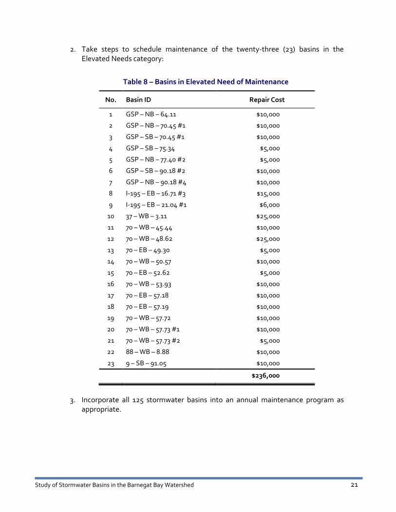
2. Take steps to schedule maintenance of the twenty-three (23) basins in the
Elevated Needs category:
Table 8 – Basins in Elevated Need of Maintenance
No. Basin ID Repair Cost
1 GSP – NB – 64.11 $10,000
2 GSP – NB – 70.45 #1 $10,000
3 GSP – SB – 70.45 #1 $10,000
4 GSP – SB – 75.34 $5,000
5 GSP – NB – 77.40 #2 $5,000
6 GSP – SB – 90.18 #2 $10,000
7 GSP – NB – 90.18 #4 $10,000
8 I-195 – EB – 16.71 #3 $15,000
9 I-195 – EB – 21.04 #1 $6,000
10 37 – WB – 3.11 $25,000
11 70 – WB – 45.44 $10,000
12 70 – WB – 48.62 $25,000
13 70 – EB – 49.30 $5,000
14 70 – WB – 50.57 $10,000
15 70 – EB – 52.62 $5,000
16 70 – WB – 53.93 $10,000
17 70 – EB – 57.18 $10,000
18 70 – EB – 57.19 $10,000
19 70 – WB – 57.72 $10,000
20 70 – WB – 57.73 #1 $10,000
21 70 – WB – 57.73 #2 $5,000
22 88 – WB – 8.88 $10,000
23 9 – SB – 91.05 $10,000
$236,000
3. Incorporate all 125 stormwater basins into an annual maintenance program as
appropriate.

APPENDICES
Appendix 1 P.L. 2010, Chapter 114
Appendix 2 Location Map
Glossary

APPENDIX 1 P.L. 2010, CHAPTER 114
AN ACT concerning the study and repair of certain stormwater basins in the Barnegat Bay watershed,
and supplementing P.L.1984, c.73 (C.27:1B-1 et seq.) and P.L.1948, c.454 (C.27:23-1 et seq.).
BE IT ENACTED by the Senate and General Assembly of the State of New Jersey:
1. The Department of Transportation, in consultation with the Department of the
Treasury, shall conduct a study of all stormwater basins owned by the State, the New Jersey Transit
Corporation, or the New Jersey Turnpike Authority in the Barnegat Bay watershed.
The study shall identify those stormwater basins owned by the State, the New Jersey Transit
Corporation, or the New Jersey Turnpike Authority in the Barnegat Bay watershed that are
malfunctioning and determine the order in which the stormwater basins should be repaired based on
the need for maintenance or restoration. The study shall also estimate the cost to repair each
stormwater basin individually.
2. Within one year of the effective date of this act, the Department of Transportation shall
prepare and submit a final report of the study conducted pursuant to section 1 of this act, including the
department’s findings and any recommendations, to the Governor, to the Legislature pursuant to
section 2 of P.L.1991, c.164 (C.52:14-19.1), and to the chairperson and members of the Assembly
Environment and Solid Waste Committee and the Senate Environment and Energy Committee, or their
successor committees. Copies of this report shall also be provided to the public upon request and free
of charge, and the report shall be posted on the Internet website of the Department of Transportation.
C.27:1B-22.4 Inclusion of projects in “Annual Transportation Capital Program.”
3. The Department of Transportation shall include, annually as part of its "Annual
Transportation Capital Program" submitted pursuant to section 22 of P.L.1984, c.73 (C.27:1B-22),
projects for the repair of malfunctioning stormwater basins owned by the State or the New Jersey
Transit Corporation in the Barnegat Bay watershed based upon the priority order identified in the study
prepared pursuant to section 1 of P.L.2010, c.114.
C.27:23-3.3 Inclusion of projects in Capital Project and Investment Plan.
4. The New Jersey Turnpike Authority shall include, annually as part of its Capital Project
and Investment Plan submitted pursuant to subsection c. of section 1 of P.L.1970, c.184 (C.27:23-3.2),
projects for the repair of malfunctioning authority-owned stormwater basins in the Barnegat Bay
watershed based upon the priority order identified in the study prepared pursuant to section 1 of
P.L.2010, c.114.
5. This act shall take effect immediately, and sections 1 and 2 shall expire on the 30th day
after the Department of Transportation submits its report as prescribed in section 2 of this act.
Approved January 5, 2011.

APPENDIX 2 LOCATION MAP

!(!(!(
!(
!(!(
!(!(
!(!(!(!(!(
!(
!(
!(
!( !(!(!(
!(!(
!(
!(
!(!(
!(
!(!(
!(!(
!(!(
!(
!(!(
!(
!(
!(!(!(
!(!(!( !(!(!(
!( !(!(!(!(!(!(!(
!(!(!(!(!(!(!(!(!(!(!(
!(!(!(!(
!(!(!(
!(!(!(!(!(!(!(!(!(!(!(
!(!(
!(
!(
!(
!(
!(!(
!(!(
!(
!(!(
!(!(
!( !(
!(
!(
Little Egg Harbor Township
Galloway Township
Port Republic City
Lacey Township
Jackson Township
Manchester Township
Bass River Township
Howell Township
Stafford Township
Berkeley Township
Toms River Township
Woodland Township
Wall Township
Brick Township
Barnegat Township
Ocean Township
Plumsted Township
Millstone Township
Lakewood Township
Freehold Township
Eagleswood Township
Upper Freehold Township
Long Beach Township
Neptune Township
Washington Township Long Beach Township
Pemberton Township
Washington Township
Tuckerton Borough
Point Pleasant Borough
Brielle Borough
Beachwood Borough
Long Beach Township
Tinton Falls Borough
Beach Haven Borough
Roosevelt Borough
Belmar Borough
Asbury Park CityManalapan Township
Manasquan Borough
Surf City Borough
Spring Lake Borough
Millstone Township
Sea Girt Borough
Point Pleasant Beach Borough
Harvey Cedars Borough
Lavallette Borough
Barnegat Light Borough
Lakehurst Borough
Seaside Park Borough
Long Beach Township
South Toms River Borough
Ship Bottom Borough
Spring Lake Heights Borough
Neptune City Borough
Bay Head Borough
Island Heights Borough
Pine Beach Borough
Ocean Township
Mantoloking Borough
Seaside Heights Borough
Ocean Gate Borough
Farmingdale Borough
Avon-by-the-Sea Borough
Lake Como Borough
New Hanover Township
Atlantic County
Ocean County
Monmouth County
Burlington County
US
9
NJ 70
I-195
NJ 3
5
NJ 72
NJ 37
GA
RD
EN
STA
TE
PA
RK
WA
Y
NJ 33
NJ 88
NJ 3
4
NJ 7
1
NJ
18
NJ 66
NJ 1
66
NJ 138
NJ
16
7
US
9
US
9
NJ 72
NJ 1
67
STATE & INTERSTATE HIGHWAYS
BARNEGAT BAY WATERSHED
OCEAN COUNTY, NJ
AREA = 660.0 SQUARE MILES
10.9 Miles
20.2 Miles
14.4 Miles
3.6 Miles
11.4 Miles
10.1 Miles
37.5 Miles
9.5 Miles
30.0 Miles
0.6 Miles
Legend
!(Basin Location
Rail Lines
Major Roads
County Boundary
Township Boundary
HUC 11 watersheds
HUC 14 watersheds
10,000 0 10,0005,000
Feetµ

GLOSSARY Detention – The temporary storage of storm runoff in a stormwater practice with the goals of
controlling peak discharge rates and providing gravity settling of pollutants.
Detention Basin – A facility constructed for the purpose of temporary storage of stream flow
or surface runoff and gradual release of stored water at controlled rates.
Drainage – 1.The removal of excess surface water or ground water from land by means of
surface or subsurface drains. 2. Soils characteristics that affect natural drainage.
Drainage Area (Watershed) – All land and water area from which runoff may run to a common
(design) point.
Extended Detention (ED) – A stormwater design feature that provides for the gradual release
of a volume of water over a 12 to 48 hour interval in order to increase settling of urban
pollutants and protect downstream channels from frequent storm events.
Infiltration Basin – An infiltration practice that stores stormwater runoff in a shallow
depression, and allows this runoff to percolate into the ground.
Retention – The amount of precipitation on a drainage area that does not escape as runoff. It
is the difference between total precipitation and total runoff.
Stormwater Wetland – A shallow, constructed pool that captures stormwater and allows for
the growth of characteristic wetland vegetation.
Wet Pond – A stormwater pond design that captures the entire water quality volume in a
permanent pool.