superfund environmental indicators guidance human exposure
TRANSCRIPT

Superfund Environmental Indicators Guidance
Human Exposure Revisions
Office of Superfund Remediation and Technology Innovation
U.S. Environmental Protection Agency
Washington, D.C. 20460
March 2008
TABLE OF CONTENTS
1.0 INTRODUCTION ............................................................................................... 1-1
2.0 ENVIRONMENTAL INDICATORS OVERVIEW ........................................... 2-1
2.1 Background ....................................................................................................... 2-1
2.2 Relationship of Interim EIs to Final Remedies................................................. 2-2
2.3 Coordination with the Resource Conservation and Recovery Act (RCRA)
Program............................................................................................................. 2-2
2.4 Updating EI Information................................................................................... 2-3
2.5 Environmental Indicator Reports...................................................................... 2-4
3.0 POPULATIONS PROTECTED AND CLEANUP VOLUMES INDICATORS3-1
3.1 Overview........................................................................................................... 3-1
3.2 Populations Protected Indicator ........................................................................ 3-3
3.2.1 Data Reporting ......................................................................................... 3-3
3.2.2 Action Types............................................................................................ 3-3
3.2.3 Populations Affected (Number of People Protected)............................... 3-4
3.3 Cleanup Volumes Indicator .............................................................................. 3-4
3.3.1 Data Reporting ......................................................................................... 3-4
3.3.2 Media Types............................................................................................. 3-5
3.3.3 Cleanup Volumes..................................................................................... 3-6
4.0 SITE-WIDE HUMAN EXPOSURE ENVIRONMENTAL INDICATOR......... 4-1
4.1 Introduction....................................................................................................... 4-1
4.2 Evaluating the Site-Wide Human Exposure (HE) Environmental Indicator .... 4-5
4.1 4.2 Information Update and Reporting Requirements.................................... 4-12
4.3 Frequently Asked Questions – Human Exposure Environmental Indicator ... 4-12
4.4 Entering Exposure Descriptions in the Justification field in CERCLIS ......... 4-22
4.5 Relationship of the Human Exposure measure to Cross Program Revitalization
Measures ......................................................................................................... 4-24
4.6 Relationship of the Human Exposure measure to Five-Year Reviews........... 4-25
5.0 MIGRATION OF CONTAMINATED GROUND WATER UNDER CONTROL
EI.......................................................................................................................... 5-1
5.1 Evaluating the Migration of Contaminated Ground Water Under Control ...... 5-1
5.2 Considering Monitored Natural Attenuation Remedies ................................... 5-8
5.3 Information Update and Reporting Requirements............................................ 5-8
5.4 Frequently Asked Questions – Migration of Contaminated Ground Water Under
Control .............................................................................................................. 5-9
APPENDIX A – DATA VIEWING ............................................................................... A-1
APPENDIX B – DATA ENTRY.................................................................................... B-1

1-1
1.0 INTRODUCTION
This document is primarily intended to provide guidance regarding Superfund
Environmental Indicators (EIs) for U.S. Environmental Protection Agency’s (EPA’s)
Superfund personnel, including Remedial Project Managers (RPMs). This document
may also be a useful resource for those interested in how Superfund EI data are collected
and how to interpret Superfund EI reporting. This guidance document provides an
overview of the Superfund EIs, including definitions, data elements/parameters/points,
and descriptions of how Superfund EI data are used to communicate the progress of
cleanups at Superfund sites. The Appendices to this manual explain the recommended
process of entering, extracting, and using Superfund EI data from CERCLIS to monitor
the results of cleanup actions and to communicate incremental progress to the public.
This document does not provide guidance on removal or response actions or remedy
selection. It is not a regulation and has no binding effect on EPA, States, the regulated
community or any other persons. The categorization of a particular site using
environmental indicators does not affect the Agency’s authorities and actions under
CERCLA, the NCP, and existing Superfund guidance, or under any other Agency
authority, and does not create any rights, obligations or defenses to liability.
In 1980, Congress passed the Comprehensive Environmental Response, Compensation,
and Liability Act (CERCLA), to clean up abandoned or uncontrolled hazardous waste
sites. CERCLA was amended in 1986 by the Superfund Amendments and
Reauthorization Act (SARA). EPA’s primary response authority is found in Section
104(a) of CERCLA which gives EPA the authority to respond to the release or threat of
release of a hazardous substance, or to a pollutant or contaminant which may present a
substantial risk to human health or the environment. EPA began developing EIs for the
Superfund Program in the early 1990s to measure the progress in protecting human health
and the environment that has occurred as a result of cleanup activities under CERCLA
across the Nation.
2-1
2.0 ENVIRONMENTAL INDICATORS OVERVIEW
2.1 BACKGROUND
EPA developed three initial program-based environmental indicators to document and
communicate environmental progress towards cleaning up Superfund sites. The three
original Superfund EIs were: Populations Protected; Progress Towards Permanent
Cleanup; and Cleanup Technologies Applied. Currently, two of these three program-
based indicators, Populations Protected and Cleanup Volumes (formerly Cleanup
Technologies Applied), are in place. Progress Toward Permanent Cleanup was
functionally replaced by the development of the construction completion category. In
2001, two additional indicators, Human Exposure Under Control (HE) and Migration of
Contaminated Ground Water Under Control (GM), were developed to measure the
interim progress in meeting the Superfund goal to protect human health and the
expectation to return usable ground waters to their beneficial use. The Site-Wide Human
Exposure (HE) EI was developed in 2004 to further refine the progress categories and
extend the focus of the HE EI beyond current conditions to measure progress in achieving
long-term human health protection.
These Superfund EIs are discussed more fully in Sections 3.0 through 5.0 of this
document.
All of Superfund’s Environmental Indicators are designed to communicate the tangible
progress made in protecting human health and the environment through site cleanup
activities. In the past, OSRTI has used Superfund EI data in Congressional testimony for
Superfund reauthorization, Government Performance and Results Act (GPRA) reporting,
and budget requests to the Chief Financial Officer. The Agency consistently requests
Superfund EI data from the Regions because the data are effective in reporting:
• The number of people protected from immediate and long-term threats through
the provision of alternate water supplies, relocation of the affected population,
and the implementation of site security and institutional controls;
• The amount of contaminated media that has been treated, stabilized, or removed
through the use of treatment or containment technologies;
• The number of sites at which current human exposure to contamination is under
control;
• The number of sites at which long-term human health protection is achieved; and
• The number of sites where the migration of contaminated ground water has been
contained within the existing area of contamination.
Subsections 2.2 - 2.5 below provide an overview of EI reporting policies, definitions, and
indicator relational diagrams. Sections 3.0 - 7.0 provide indicator-specific guidance
including data elements/parameters/points, instructions for data reporting, and guidelines

2-2
used to make EI evaluations. This guidance is intended to provide Superfund personnel
with information to capture the most current, complete EI data available.
2.2 RELATIONSHIP OF INTERIM EIS TO FINAL REMEDIES
The HE and GM Superfund EIs are designed to document interim progress in reaching
final cleanup goals at NPL sites. However, the fundamental goal of the program has not
changed. The goal of Superfund remedies is still to protect human health and the
environment, maintain protection over time, and to minimize untreated waste (see, e.g.,
NCP, Section 300.430(a)(1)(I)). The CERCLA program often realizes this goal at NPL
sites by implementing final remedies to achieve cleanup goals specified in Records of
Decision.
The focus of the HE and GM indicators on interim progress in no way is intended to
change the goal of the remedial process to provide remedies that are protective of human
health, maintain protection over time, and minimize untreated waste. Achieving an
interim category for the HE EI or a “ground water migration under control” evaluation
for the GM Superfund EI should not substitute for meeting final remedy requirements,
expectations associated with sources of contamination, and the need to restore, wherever
practicable, contaminated ground water to beneficial use. In addition, achieving the final
category for the Site-Wide Human Exposure indicator should not substitute for meeting
final remedy requirements that are driven by ecological risks.
2.3 COORDINATION WITH THE RESOURCE CONSERVATION AND RECOVERY ACT
(RCRA) PROGRAM
OSRTI developed the HE and GM Superfund indicators to be as consistent as possible
with the comparable HE and GM indicators developed by EPA’s Office of Solid Waste
for the RCRA Corrective Action program. The Superfund indicators incorporate the
specific provisions of the Superfund program and take advantage of its unique data
sources.
The Site-Wide Human Exposure indicator expanded on the earlier Human Exposure
Under Control indicator which it incorporates as its third progress category, “current
human exposures controlled.” Current human exposure control is a prerequisite for
achieving higher progress categories under the Site-Wide Human Exposure measure.
Where both RCRA and CERCLA authorities are being used to address different areas of
the same site, it is very important for the CERCLA and RCRA program managers to
work together to make a consistent evaluation for the site, since both of these indicators
apply site-wide. If a “current human exposures under control” evaluation cannot be made
under the RCRA program, a “current human exposures controlled” evaluation generally
cannot be made for the HE indicator. Similarly, GM EI evaluations should be consistent
when both programs are addressing the same site.
2-3
2.4 UPDATING EI INFORMATION
In FY 1992, EPA Regions began recording environmental progress information directly
in CERCLIS to make data collection more efficient and timely and to standardize
reporting cycles. In FY 1995, evaluations for the initial three program-based EIs were
first reported. Evaluations for the prior HE and GM Superfund EIs were first reported in
FY 2001. The Site-Wide Human Exposure EI was reported beginning in mid-year FY
2005. Section 2.5 summarizes Environmental Indicator Reports available through
CERCLIS.
Many Environmental Indicator data points have been incorporated into the Superfund
Comprehensive Accomplishment Plan (SCAP). For further information, see the most
recent version of Appendix B of the Superfund /Oil Program Implementation Manual
(SPIM).
At a minimum, Regional personnel should update Cleanup Volume and Populations
Protected data in CERCLIS by the 10th working day in October for end-of-year reporting
purposes. Sections 4.2 and 5.3 provide specific guidance for updating the Human
Exposure and Groundwater Migration indicators. As data collection and analysis or
response actions occur or environmental conditions change, it is expected that Regions
will update these evaluations and update CERCLIS to reflect changes in status. This
should generally occur within 10 days of a known change. It is expected that Regions will
review the status of all Human Exposure and Groundwater Migration evaluations at a
minimum annually and confirm that each site has an updated and accurate HE evaluation
by the 5th working day in October.
2-4
2.5 ENVIRONMENTAL INDICATOR REPORTS
Environmental Indicator Reports were developed to assist the Regions with data entry to
facilitate National and site-specific report viewing. OSRTI refines the EI reporting
system by noting any defects and enhancements that appear in the CERCLIS User
Request System, as well as through contact with EPA Headquarters and Regional
personnel. The following tools are currently available in CERCLIS to facilitate data
entry and viewing:
• PGMT-08 Environmental Indicators Audit Report
The EI Audit Report displays sites where there are incomplete or missing
Environmental Indicators data. It displays discrepancies in EI data at the national,
regional, state, or site-specific levels. For example, an error code and description
will be generated in the report if a Populations Protected-specific action has been
selected, but is not accompanied by the number of people affected by that
particular action.
A universe of EI Legacy sites has been identified to prevent the PGMT-08 EI
Audit Report from identifying errors under the Populations Protected and Cleanup
Volumes EIs. For the purposes of this policy, EI Legacy sites are defined as sites
listed prior to 1995 (i.e., prior to implementation of the Populations Protected and
Cleanup Volumes EIs) where no pipeline actions are ongoing or planned. EI
Legacy sites are excluded from PGMT-08 audit reporting for the Populations
Protected and Cleanup Volumes EIs. Missing data for EI Legacy Sites are
reported in the PGMT-12 report for the HE or GM Superfund EIs (see below).
• PGMT-09 Data Compilation Report
The Data Compilation Report is a summary of site data that can be used in
conjunction with the PGMT-08 report to ensure that all data for a site are entered
completely and accurately. This report displays the most recent information
entered into CERCLIS and is useful for the review of start and completion dates.
• PGMT-10 Site Turnaround Report
The Site Turnaround Report lists key progress information for a specific site or
for all sites managed by a selected RPM or OSC. Progress information that
populates this report includes: Cleanup Volume Data, Populations Protected Data,
technology selected for each media, action start and complete dates by operable
unit and lead type, site contact information, and the program priorities associated
with the site. The report is intended to serve as a data summary for RPMs, and as
an effective quality assurance record for confirming that EI data are entered
accurately into the system.

2-5
• PGMT-11 Environmental Indicators HE/GM Report
The EI HE/GM Report is a site-wide summary detail and Regional summary
count of HE and GM evaluations and last Regional and Headquarters review
dates. This report is intended to be a quick reference guide for use by both
Headquarters and the Regions.
• PGMT-12 Environmental Indicators HE/GM Error Report
The HE/GM Error Report displays a site summary of data gaps and potential
reporting errors for the HE and GM EIs. Errors are reported for sites missing an
HE or GM evaluation.
• PGMT-13 Environmental Indicators Summary Report
The PMGT-13 is a quick reference cumulative summary of all EI data. This
report includes NPL and non-NPL totals of solid waste (hazardous soil, solid
waste, and sediment) and liquid waste (hazardous liquid waste, ground water, and
surface water), the number of people provided alternative drinking water, and the
number of people either temporarily or permanently relocated and the number of
people returned. In addition, the report provides HE and GM totals by evaluation
type.

3-1
3.0 POPULATIONS PROTECTED AND CLEANUP VOLUMES
INDICATORS
3.1 OVERVIEW
The Populations Protected EI measures the progress made in protecting individuals living
at or near Superfund sites from immediate threats of exposure to contaminated media. It
measures the number of individuals protected through the provision of alternate drinking
water supplies or relocation in response to contamination. The Cleanup Volumes EI
documents the amount of contaminated media that has been treated, stabilized, contained,
or removed through the use of risk management technologies, engineering techniques, or
institutional controls at NPL and non-NPL sites.
The Populations Protected indicator is reported at the action level, while the Cleanup
Volumes indicator is reported on an action and medium-specific basis. Exhibit 1 shows
the relationships among CERCLIS Populations Protected EI, Cleanup Volumes EI, and
remedial and removal actions, and contaminated media data.

3-2
Exhibit 1: Recommended Crosswalk of Environmental Indicators to Reported
Progress Information
Sites with Removal or Remedial Actions1
1 Removal and Remedial actions that should/may involve EI reporting include: Removals (RV); PRP
Removals (BB); FF Removals (LV); PRP Emergency Removals (PJ); Remedial Actions (RA); PRP RAs
(BF); Federal Facility RAs (LY); and Initial Remedial Measures (IP).
3-3
3.2 POPULATIONS PROTECTED INDICATOR
The Populations Protected Superfund EI was developed to measure the progress made in
protecting individuals living at or near Superfund sites from immediate threats of
exposure to contaminated media. Specifically, this EI is designed to measure the number
of individuals protected through the provision of alternate drinking water supplies or
relocation in response to contamination.
3.2.1 DATA REPORTING
Certain removal and remedial actions may generate Populations Protected EI data. The
Populations Protected EI is designed to provide a means for describing the types of
actions used to protect people living at or near Superfund sites.
3.2.2 ACTION TYPES
In general, Populations Protected EI data should be reported by the Regions when a
removal or remedial action provides for:
• Alternate sources of drinking water, either temporarily or permanently;
• Reinstatement of drinking water supply following provision of temporary supply;
• Relocation, either permanently or temporarily; or
• Return of population following temporary relocation.
When a removal or remedial action is conducted, the action and the following details
describing the action should be reported:
• The date the population was either relocated or provided alternative drinking
water;
• The level at which the population was relocated or provided alternative drinking
water (temporarily, permanently, or returned/reinstated); and
• The number of people relocated or provided alternative drinking water.
To obtain the most accurate description of site activity, Regions should designate as
many actions as necessary to characterize how people were protected from immediate
and long-term threats posed by site contamination. Data related to this indicator can
typically be found by reviewing RODs, Action Memoranda, pollution reports
(POLREPS), Remedial Action Reports, and Close Out Reports.

3-4
3.2.3 POPULATIONS AFFECTED (NUMBER OF PEOPLE PROTECTED)
Regions should report the number of people who were provided alternate water supply or
were relocated either temporarily or permanently. In addition, the population whose
water supply has been reinstated or a population who has been returned from relocation
should also be recorded. If the population in the site records is listed as number of homes
or residences and not the actual number of people relocated, Regions should use Census
statistics (http://www.census.gov/) for county-level data on average number of people per
household and multiply by the number of households to obtain a good estimate of the
number of people protected. For a quick estimate, the Year 2000 US Census estimates
that there were an average of 2.69 people per owner-occupied household and 2.40 people
per renter-occupied household. Finally, Regions should round the estimate to the nearest
whole number, as there are no fractions of people.
See Appendix B for a more detailed discussion of data entry.
3.3 CLEANUP VOLUMES INDICATOR
The Cleanup Volumes Indicator was developed to measure the amount of contaminated
media that has been treated, stabilized, contained, or removed through the use of risk
management technologies, engineering techniques, or institutional controls.
3.3.1 DATA REPORTING
For this indicator, Regions should report the following information:
• Date that the quantity of contaminated media were addressed;
• Media addressed by a removal or remedial action; and
• Quantity of contaminated media addressed by each removal or remedial action
reported in CERCLIS.
Often, a single medium may be addressed by multiple actions. If that is the case,
multiple entries may exist for a single medium. To assist in data entry and reporting,
media associated with different actions can be named accordingly in the SCAP or
Remedy Selection screens (e.g., Soil 01 and Soil 02). Data associated with this indicator
can be found in RODs, Action Memoranda, POLREPS, Interim RA Reports, Final RA
Reports, and Close Out Reports.

3-5
3.3.2 MEDIA TYPES
Media types are carried over to the Add/Edit EI screen from other areas in CERCLIS,
such as the Remedy Selection or SCAP-Selected Remedy Screens. If a medium is not
present for a volume to be entered, Regions should add that medium on the Add/Edit
Media screen via the SCAP or Remedy selection screens as mentioned in Sections 3.2.1
and 3.3.1. Once the medium has been entered, it should be available on the Cleanup
Volume tab in the Add/Edit EI module for entry along with its corresponding volume.
Regions should use the following descriptions as a guide to assist in reporting the types
of contaminated media that have been addressed:
• Air: Gases from processes such as landfilling or thermal treatment.
• Debris: Large solid waste, such as machinery, buildings, and tanks.
• Ground water: Water in the ground, both shallow and deep aquifers.
• Leachate: Rainwater, surface water, or ground water filtered through a landfill.
• Liquid waste: Waste such as acid contained in tanks, drums, lagoons, or ponds.
• Residuals: Waste remaining after treatment, such as incinerator ash.
• Sediment: Solids settled out of surface water or dredged material.
• Sludge: Solids settled out of a liquid, for example following wastewater
treatment.
• Soil: Soil not distinguished as surface or subsurface.
• Solid waste: Discarded material such as garbage, refuse, tars, and contained
gaseous materials but excluding for CERCLIS purposes debris, liquid waste, and
sludge.
• Subsurface soil: Generally, soil below surface soil and at a depth of 2 feet and
below.
• Surface soil: Generally, the top 2 feet of soil, but may be deeper depending on
site-specific conditions and exposures.
• Surface water: Water open to the air, such as wetlands, lakes, streams, ponds,
and overland surface flow.

3-6
3.3.3 CLEANUP VOLUMES
Regions should record in CERCLIS the volumes of contaminated media that have been
addressed. The current Add/Edit EI screen allows for the entry of incremental volumetric
data. It is important to add a new cleanup date and corresponding volume each time a
new volume of waste has been addressed. For example, if 200 cubic yards (cu yd) of
solid waste were reported as previously treated, and an additional 100 cu yd are currently
being treated, a new separate entry of 100 cu yd of solid waste should be created along
with the cleanup date. Cumulative totals by media can be viewed on the Add/Edit EI
Summary tab.
Cleanup volumes can be entered for non-standard units available in the drop-down list
(cubic feet, drums, liters, tons, pounds, cubic meters, tanks, cylinders, and battery
casings). Once selected, these non-standard units will convert to standard units of
gallons for liquid-based waste and cubic yards for solid-based waste. Appendix B
provides a more detailed discussion of data entry for Cleanup Volumes.

4-1
4.0 SITE-WIDE HUMAN EXPOSURE ENVIRONMENTAL INDICATOR
4.1 INTRODUCTION
The Site-Wide Human Exposure2 (HE) environmental indicator is designed to document
long-term human health protection on a site-wide basis by measuring the incremental
progress achieved in controlling unacceptable human exposures at a Superfund site.
These evaluations currently apply to final and deleted Superfund National Priorities List
(NPL) sites, and beginning in fiscal year (FY) 2008 to proposed NPL sites and to
Superfund Alternative (SA) Sites.3
In making the evaluation on human exposure, Regions should have knowledge or
information regarding the following factors:
• A site's physical setting and how that contributes to human exposure;
• Potential or actual exposed populations;
• Potential or actual exposed pathways;
• Estimates of exposure concentrations;
• Estimates of chemical intakes; and
• Evaluation of Uncertainty regarding the above factors.
Complete certainty regarding the above factors is not a necessary condition to make a
human exposure determination at a site. In characterizing a site as "current human
2 "Exposure is defined as the contact of an organism (humans in the case of health risk assessment) with a
chemical or physical agent. The magnitude of the exposure is determined by measuring or estimating the
amount of an agent available at the exchange of boundaries (i.e., the lungs, gut, skin) during a specified
time period. Exposure assessment is the determination or estimation (qualitative or quantitative) of the
magnitude, frequency, duration and route of exposure. Exposure assessments may consider past, present
and future exposures using varying assessment techniques for each phase. Estimates of current exposures
can be based on measurements or models of existing conditions, those of future exposures can be based on
models of future conditions, and those of past exposures, can be based on measured or modeled past
concentrations or measured chemical concentrations in tissues. Generally, Superfund exposure assessments
are concerned with current and future exposures." For more information see RAGS - Part A - Chapter 6 at
http://www.epa.gov/oswer/riskassessment/ragsa/index.htm.
3 Prior to the publication of this guidance, HE evaluations were made only for Superfund final and deleted
National Priorities List (NPL) sites. Beginning in fiscal year (FY) 2008, Regions should expand their
evaluations to include proposed NPL sites and Superfund Alternative (SA) Sites. Results for these site
categories will be reported separately. Regions should enter human exposure evaluations into CERCLIS
before the end of FY 2008, and update these evaluations thereafter consistent with this guidance. For SA
Sites, the HE evaluation should apply only to those sites that are actively using the Superfund Alternative
approach. These are non-NPL sites with a signed, enforceable agreement for RI/FS, RD, RA or NTCRA
finalized after June 2002 where: (a) the agreement contains the SA provisions or has prior written approval
to omit the provisions, or (b) the agreement is consistent with EPA SA guidance. For more information
regarding SA evaluations, consult "Revised Response Selection and Settlement Approach for Superfund
Alternative Sites (OSWER 9208.0-18, June 2004).
4-2
exposures not under control", a region is making a determination that: 1) there are
currently completed human exposure pathways and 2) that those exposure pathways pose
an unacceptable risk to humans based on the magnitude, frequency, duration and route(s)
of exposure relative to the exposure concentrations and chemical intakes. Where a region
lacks sufficient information to make such a determination on whether there are completed
pathways or whether a completed pathway poses an unacceptable risk, a site should be
classified as "insufficient data to determine human exposure control status". A site is
placed in one of the three "under control" categories when a Region has determined that
there are not currently completed human exposure pathways or that exposure(s) that may
be occurring do not pose an unacceptable risk to humans based on the magnitude,
frequency, duration and route(s) of exposure relative to the exposure concentrations and
chemical intakes.
“Unacceptable human exposures,” for purposes of this policy, are defined as actual or
reasonably expected exposures of an individual to hazardous substances, pollutants, or
contaminants at levels that present an “unacceptable risk,” where unacceptable risks are
determined on a site-specific basis relative to EPA policy (e.g., risks in excess of the
cancer risk range). Unacceptable human exposures generally can be
controlled by:
• Reducing the level of contamination.4 For purposes of this policy,
“contamination” generally refers to media containing contaminants in
concentrations above appropriate protective risk-based levels associated with
complete exposure pathways to the point where the exposure is no longer
"unacceptable;" and/or
• Controlling or eliminating contaminant migration to human receptors; and/or
• Preventing human receptors from contacting contaminants in-place, and/or;
• Controlling human receptor activity patterns (e.g., by reducing the potential
frequency or duration of exposure).
(As always, where EPA determines that a situation may present an imminent and
substantial endangerment to human health or the environment, the Agency has broad
response and enforcement authority to take appropriate action. This authority is not
extinguished (i.e., the finding of imminent and substantial endangerment may still apply
to the site) by the EPA’s environmental indicator categorization. It is anticipated that
final remedies will address future human exposure scenarios, future land and
groundwater uses, and ecological receptors, whenever appropriate.)
Five categories have been created to describe the level of human health protection
achieved at a site:
4 For purposes of this policy, “contamination” generally refers to media containing contaminants in
concentrations above appropriate protective risk-based levels.
4-3
1) Insufficient data to determine human exposure control status;
2) Current human exposures not under control;
3) Current human exposures under control;
4) Current human exposures under control and protective remedy or remedies in place;
and
5) Current human exposures under control and long-term human health protection
achieved.
The categories describe the status of human exposure control and provide a measure of
EPA's assessment of the progress in controlling site-wide human exposure. For the
purposes of reporting EPA’s Government Performance and Results Act
accomplishments, the latter three categories are combined into a single category reported
as “Human Exposure Under Control.” The last two categories above apply to sites where
site-wide current human exposures are under control and track the progress in achieving
more permanent, long-term control and protection at these sites.
The category “Current human exposures under control and long-term human health
protection achieved” is typically achieved when all current and reasonably anticipated
future human exposures have been addressed using treatment technologies, engineering
controls, and/or institutional controls, and human exposure-related cleanup goals have
been met for the entire site. The title of this category recognizes that once all human
exposure-related cleanup goals have been met, additional progress has occurred beyond
“human exposure control.” Most Superfund remedies include a combination of
components that “control” or “mitigate” human exposures (e.g., engineering or
institutional controls designed to control contact with waste left in place) and components
that “eliminate,” human exposures (e.g., excavation and treatment remedies). The term
“long-term human health protection” generally describes the condition achieved when all
human exposure-related cleanup goals have been met and encompasses the broad range
of Superfund remedies.
Please refer to Appendix B for detailed instructions on entering this evaluation in
CERCLIS.

4-4
Table 4-1 below provides a recommended description of each progress category and the
typical site to which each category may apply.
Table 4-1 – Description of Progress Categories for the Site-Wide Human Exposure
Superfund Environmental Indicators Category Description General Site Types
Insufficient data to
determine human exposure
control status
Due to uncertainty regarding exposures,
one cannot draw conclusions as to
whether human exposures are
controlled. Sites are typically assigned
to this category when responses have
not been initiated or response actions
have been initiated but have not yet
generated reliable information to make
an evaluation for this indicator - i.e.,
there is not sufficient information to
determine whether there are any
current, complete unacceptable human
exposure pathways at the site, therefore
no evaluation is possible.
This category would apply primarily to
sites that are in the initial phases of
remedial investigation (e.g., recently
proposed or listed NPL sites), or sites at
which an investigation is underway to
assess a potential exposure pathway not
previously analyzed (e.g., vapor
intrusion), but sufficient information has
not been developed to make an
evaluation about the human exposure
risk. It may also apply to any site at
which new information calls into
question the nature of the human
exposure pathways.
Current human exposures
not under control
Sites are assigned to this category when
data indicate that there are complete
human exposure pathways that present
unacceptable exposures to humans, and
actions have yet to be completed to
address these human exposure pathways
for the entire site.
Sites typically in this category include
those sites with human exposure data
indicating unacceptable exposure
pathways are present and exposure
pathways have not been controlled,
mitigated or eliminated. This will
typically include sites where response
actions are underway but are not yet
complete.
Current human exposures
under control
Sites are assigned to this category when
assessments for human exposures
indicate there are no unacceptable
human exposure pathways and the
Region has determined the site is under
control for current conditions site-wide.
However, there is additional physical
construction required which may
include system shake-down, and/or
institutional controls need to be
implemented to address long-term
human health exposures.
Sites in this category would usually
include those sites where human
exposures are acceptable and under
control for current conditions (i.e., there
are no unacceptable human exposures).
However in this instance sites have yet to
attain Construction Completion status.
This category also would include
Construction Completion sites where
cleanup levels have yet to be achieved,
ground water treatment systems are
undergoing shake-down to demonstrate
that they are operating as intended,
and/or institutional controls are required
but are not in place to prevent current
exposure above acceptable levels.

4-5
Table 4-1 – Description of Progress Categories for the Site-Wide Human Exposure
Superfund Environmental Indicators Category Description General Site Types
Current human exposures
under control and all
protective remedy(ies) in
place
Sites are assigned to this category when
assessments for human exposures
indicate there are no unacceptable
human exposure pathways and the
Region has determined the site is under
control for current conditions site-wide.
In addition, all physical construction is
complete, systems are operating as
intended, and institutional controls are
in place and effective. However, one or
more of the human exposure-related
cleanup goals for the site have yet to be
met.
This category includes Construction
Completion sites where long-term
remedial actions (LTRAs) or O&M
activities (only) are underway to achieve
cleanup levels and all institutional
controls required to prevent
unacceptable human exposures are in
place. In addition to LTRAs, this
category includes Construction
Completion sites requiring O&M after
the LTRA period, involving a ground
water or surface water remedy with the
primary purpose to provide drinking
water supply, or involving in-situ SVE or
bioremediation where cleanup levels
have yet to be met.
Current human exposures
under control and long-
term human health
protection achieved
Sites are assigned to this category when
assessments for human exposures
indicate there are no unacceptable
human exposure pathways and the
Region has determined the site is under
control for current conditions site-wide.
In addition, all physical construction is
complete, systems are operating as
intended, and institutional controls are
in place and effective. Finally all
human exposure-related cleanup goals
for the site have been achieved.
This category would typically include:
(1) Construction Completion sites that do
not involve long-term soil, groundwater
or surface water restoration remedies and
all institutional controls are in place, (2)
Construction Completion sites that have
achieved long-term soil, groundwater and
surface water restoration cleanup levels
and all institutional controls are in place,
(3) sites that have attained Site
Completion status, and (4) Deleted NPL
sites.
4.2 EVALUATING THE SITE-WIDE HUMAN EXPOSURE (HE) ENVIRONMENTAL
INDICATOR
The following guidelines should be observed when making the HE evaluation:
• The evaluation should be made on a site-wide basis;
• All response actions across all media should be considered;
• The evaluation should be made with “reasonable certainty” (i.e., based on the
most current data for the site)5;
• The evaluation is intended to be a realistic, risk-based evaluation based on actual
and reasonably anticipated land, surface water and groundwater use; and
• The evaluation can and should be revised as new information becomes available.
5 Documents such as risk assessments, RODs, Action Memoranda, POLREPS, RA Reports, Close-out
Reports, Five-year Reviews, NPL Deletion/Partial Deletion Notices are known reliable sources of data and
often provide the information necessary for making an evaluation with reasonable certainty.
4-6
For national consistency, EPA Regions should use the recommended step-by-step process
listed on the following pages to make an evaluation of the appropriate HE site progress
category. These steps were developed in cooperation with representatives from all ten
Regional Superfund programs, and are designed to assist Regional project managers in
making accurate HE evaluations.
Please refer to Appendix A and B of this guidance for more detailed instructions
regarding CERCLIS data entry. When making evaluations regarding the human
exposure status at any site, Regional personnel should document the sources of
information used to make the evaluation in the "List site reference document" fields in
CERCLIS and/or a "note to the file" kept for that particular site.
In making a HE evaluation, the following five steps should be followed:
(Step 1) Determine whether there is sufficient known and reliable information to
make an evaluation.
- If information is not sufficient, the site should be assigned category of
“Insufficient data to determine human exposure control status."
- If information is sufficient, proceed to Step 2.
Considerations for evaluating a site at this step:
- The purpose of this step generally is to identify and screen those sites for
which information (i.e., human exposure and risk data) is insufficient to
make an evaluation for this indicator. If an RPM is unable to make a
definitive evaluation on the nature of human exposure other than
“insufficient information,” a site would be classified in this category.
- Review and consider information that is pertinent to the evaluation of
human exposure. Consider all available sources, even if you decide to
base the indicator evaluation on one source or a subset of sources.
- Documents such as RI/FS reports, Baseline Risk Assessments, RODs,
Action Memoranda, POLREPS, RA Reports, Close Out Reports, Five-
Year Reviews, etc. are known and reliable sources of information.
Document the sources of information used to make the evaluation in the
"List site reference document" fields in CERCLIS and/or a "note to the
file" kept for that particular site.
4-7
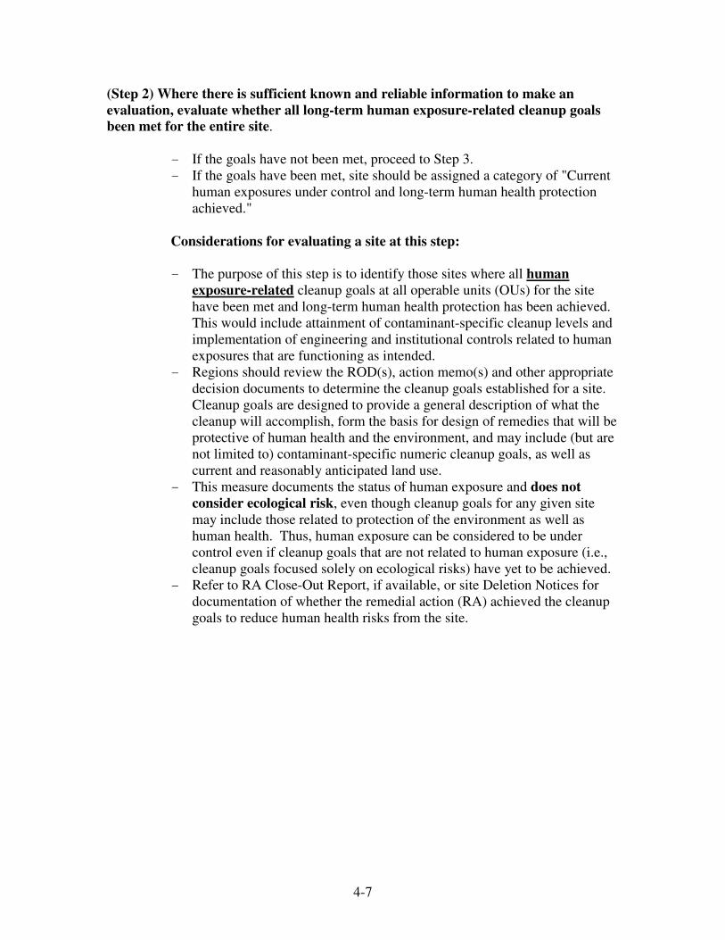
(Step 2) Where there is sufficient known and reliable information to make an
evaluation, evaluate whether all long-term human exposure-related cleanup goals
been met for the entire site.
- If the goals have not been met, proceed to Step 3.
- If the goals have been met, site should be assigned a category of "Current
human exposures under control and long-term human health protection
achieved."
Considerations for evaluating a site at this step:
- The purpose of this step is to identify those sites where all human
exposure-related cleanup goals at all operable units (OUs) for the site
have been met and long-term human health protection has been achieved.
This would include attainment of contaminant-specific cleanup levels and
implementation of engineering and institutional controls related to human
exposures that are functioning as intended.
- Regions should review the ROD(s), action memo(s) and other appropriate
decision documents to determine the cleanup goals established for a site.
Cleanup goals are designed to provide a general description of what the
cleanup will accomplish, form the basis for design of remedies that will be
protective of human health and the environment, and may include (but are
not limited to) contaminant-specific numeric cleanup goals, as well as
current and reasonably anticipated land use.
- This measure documents the status of human exposure and does not
consider ecological risk, even though cleanup goals for any given site
may include those related to protection of the environment as well as
human health. Thus, human exposure can be considered to be under
control even if cleanup goals that are not related to human exposure (i.e.,
cleanup goals focused solely on ecological risks) have yet to be achieved.
- Refer to RA Close-Out Report, if available, or site Deletion Notices for
documentation of whether the remedial action (RA) achieved the cleanup
goals to reduce human health risks from the site.

4-8
(Step 3) Determine whether there are complete human exposure pathways between
contaminated ground water, soil, surface water, sediment, or air media and human
receptors such that exposures can be reasonably expected under current conditions.
- If there are not complete pathways, proceed ahead to Step 5.
- If there are complete pathways, proceed to Step 4.
Considerations for this step:
- The purpose of this step is to identify whether there are any complete
human exposure pathways between human receptors and “contaminated”
media under current land and ground water use conditions.
- Media should be considered “contaminated” for this EI if they are known
or reasonably suspected to be contaminated above appropriately protective
human health risk-based levels from known contaminants. Appropriate
human health risk-based levels would include, among other things,
ARARs and/or risk-based levels documented in the ROD.
- All contaminants of potential concern present at the site above human
health risk-based screening levels as discussed in the risk assessment
should be considered for sites without a ROD. In such cases it is
important to document the sources of information used to make the
evaluation in the "List site reference document" fields in CERCLIS and/or
a "note to the file" kept for that particular site. For sites with a ROD,
Regions should consider contaminants of concern identified in the ROD.
- To facilitate its evaluation, Regions should use the table below and modify
as needed to identify potential human exposure pathways (under current
conditions). Regions should consider indirect and direct exposure
pathways, including indoor air (vapor intrusion pathway) or exposure to
contaminated food (e.g., fish, shellfish, dairy, edible plants, etc.).
- Regions should consider the exposure scenarios being evaluated for risk
management decisions for the site. Note that some exposure pathways
identified as complete in the baseline risk assessment may be identified as
incomplete in this EI evaluation if the pathway was eliminated under
current conditions using institutional or engineering controls.
- Regions should consider not only the presence of controls intended to
eliminate exposure potential but also their effectiveness. Regions should
consider the toxicity of the contamination, frequency, and duration of
exposure to decide whether exposure is likely to occur at unacceptable
levels. Anecdotal or random evidence (e.g., a cut fence) would not
necessarily result in a evaluation of “not under control” unless conditions
are such that exposure at unacceptable levels is reasonably expected to
occur.

4-9
Sample Exposure Pathway Evaluation Table
Note: In order to focus the evaluation on the most probable combinations, some potential “Contaminated”
Media - Human Receptor combinations (pathways) do not have spaces for check marks. While these
combinations are not likely in most situations, they may be appropriate in some settings and should be
added as necessary.
(Step 4) Determine whether the actual or reasonably expected human exposures
associated with the complete pathways identified in Step 3 are within acceptable
limits under current conditions.
- If the exposures are not within acceptable limits, current human exposures
are not under control.
- If the exposures are within acceptable limits, proceed ahead to Step 5.
Considerations for this step:
- The purpose of this step is to identify whether the complete exposure
pathways identified in Step 3 could result in unacceptable human
exposures under current conditions.
- Determine “acceptable limits” by considering the cancer risk range, the
Hazard Index, or other appropriate information (e.g., blood lead data).
- A positive evaluation could be made for this step if the frequency and/or
duration of exposure associated with complete pathways is such that the
risk is acceptable (e.g., for a utility worker) and the cleanup goals that
have yet to be met (Step 2) address reasonably anticipated future
exposures.

4-10
- Information regarding current exposures should be derived from risk
assessments and/or RODs. Note that if the exposures driving the remedy
are based on future use only, and future use conditions are different than
current, it may be necessary to review the risk assessment (not just the
ROD) to obtain data on current risks.
(Step 5) Determine whether the site is Construction Complete, whether the remedy
operating as intended, and whether the engineering and institutional controls, if
required, are in place and effective.
- If at least one of these criteria is not met, site should be assigned a
category of "Current human exposures under control."
- If all of these criteria are met, site should be assigned a category of
"Current human exposures under control and protective remedy or
remedies in place."
Considerations for this step:
- The purpose of this step is to categorize sites where current human
exposures are under control but long-term human health protection has yet
to be attained.
- This step should be used to distinguish between sites where current human
exposures are under control and a “protective remedy” is or is not in place.
For the purposes of this EI, sites that are construction complete should
also be “operating as intended” (an Operational & Functional (O&F)
evaluation pursuant to the National Contingency Plan has been made for
ground water or surface water restoration remedies) and institutional
controls, where required, should be in place in order to answer “yes” to
this question.
- Sites with a “protective remedy in place” typically would include
construction completion sites where long-term remedial actions (LTRAs)
or O&M activities are underway to achieve cleanup levels and institutional
controls to prevent unacceptable human exposures are in place. In
addition to LTRAs, this could include construction completion sites
requiring O&M after the LTRA period, involving a ground water or
surface water remedy with the primary purpose to provide drinking water
supply, or involving in-situ SVE or bioremediation where cleanup levels
have yet to be met.
Accounting for sites where property owners have refused to
participate in the remedy response
At some sites, EPA and/or a state agency, a PRP or another Federal
Agency may have exhausted all response actions and legal authorities to

4-11
prevent unacceptable human exposures, yet some exposures may continue
based on a decision by a property owner not participate in the remedy.
This guidance now provides Regions the discretion to categorize a site as
Human Exposure Under Control in certain of these situations where the
effect of property owners’ decision is limited to the owner and/or their
property. For example, at some sites, property owners have chosen to
drink potentially-contaminated well water instead of freely-provided
bottled water. In contrast, a site would be categorized as not under control
where an owner does not allow access to remediate his/her yard, and
contaminated dust from that owner's property contaminates adjoining
properties above health based levels. Regions should not exercise this
discretion in the case of rental properties, where tenants may not have the
power to make such decisions.
Where such situations are encountered, and a Region decides to classify
such site in one of the “Under Control” categories, a Region should
document, track, and review each of these sites as outlined below:
1. Document in the site files all steps taken to inform property owner and
occupants of the potential or known contamination and the exposure
risk that may result from their decision to refuse access or assistance.
The property owner/resident’s response should be included in such
documentation.
2. Include a set schedule for frequent periodic review of the site so that:
1) property owners/occupants are reminded that exposures have still
not been addressed and that they are given periodic opportunities to
allow access or accept a remedy, and 2) the Region can ensure that the
EI status is still current.
3. Draft a concise explanation of the exposure conditions at the site,
describing the actions taken to address exposures at the site as well as
the nature of any continuing exposures. This explanation will be
placed on the Superfund Site Profile Internet site to provide the public
with a succinct and clear description of why a site is so listed.
4. Prior to making the Human Exposure category change in CERCLIS,
consult with the OSRTI Headquarters Environmental Indicator lead to
discuss the documentation, periodic review process, and exposure
explanation listed above.
4-12
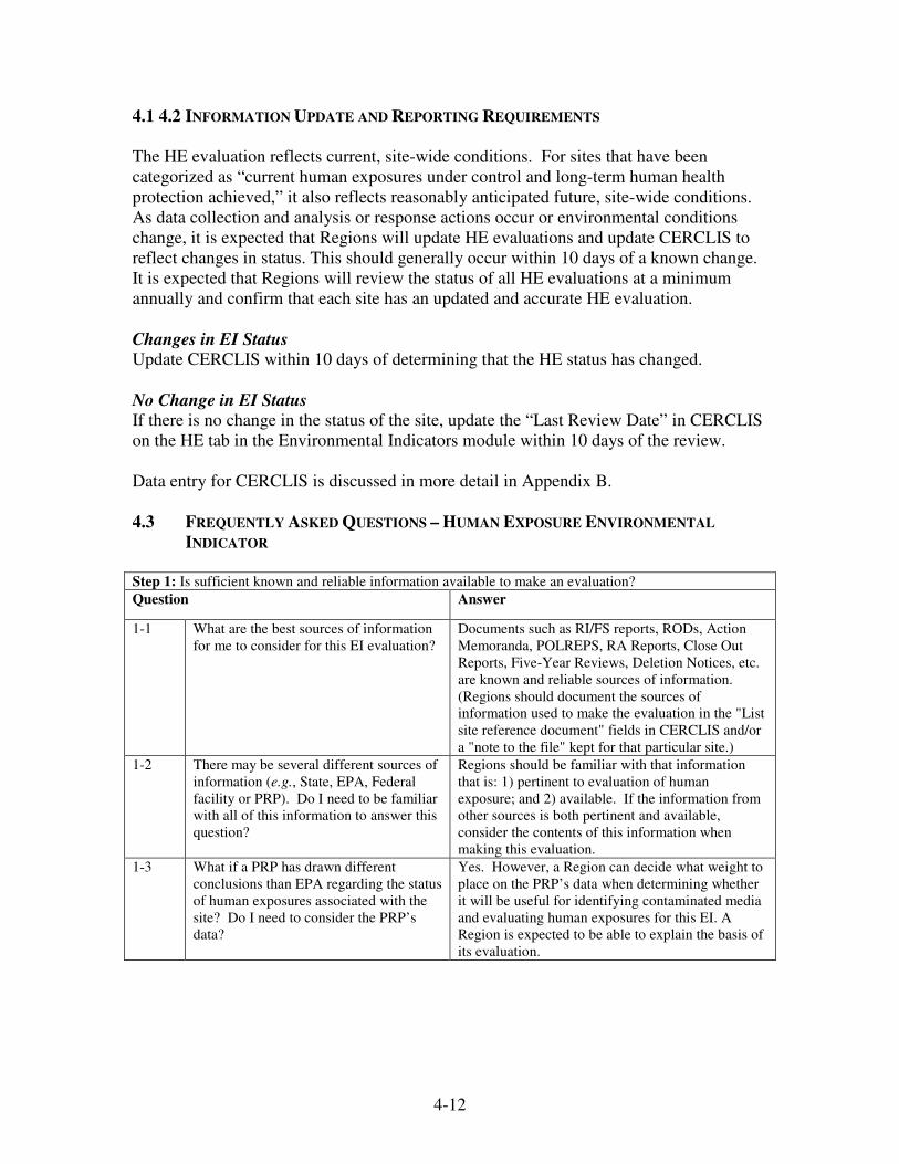
4.1 4.2 INFORMATION UPDATE AND REPORTING REQUIREMENTS
The HE evaluation reflects current, site-wide conditions. For sites that have been
categorized as “current human exposures under control and long-term human health
protection achieved,” it also reflects reasonably anticipated future, site-wide conditions.
As data collection and analysis or response actions occur or environmental conditions
change, it is expected that Regions will update HE evaluations and update CERCLIS to
reflect changes in status. This should generally occur within 10 days of a known change.
It is expected that Regions will review the status of all HE evaluations at a minimum
annually and confirm that each site has an updated and accurate HE evaluation.
Changes in EI Status
Update CERCLIS within 10 days of determining that the HE status has changed.
No Change in EI Status
If there is no change in the status of the site, update the “Last Review Date” in CERCLIS
on the HE tab in the Environmental Indicators module within 10 days of the review.
Data entry for CERCLIS is discussed in more detail in Appendix B.
4.3 FREQUENTLY ASKED QUESTIONS – HUMAN EXPOSURE ENVIRONMENTAL
INDICATOR
Step 1: Is sufficient known and reliable information available to make an evaluation?
Question Answer
1-1 What are the best sources of information
for me to consider for this EI evaluation?
Documents such as RI/FS reports, RODs, Action
Memoranda, POLREPS, RA Reports, Close Out
Reports, Five-Year Reviews, Deletion Notices, etc.
are known and reliable sources of information.
(Regions should document the sources of
information used to make the evaluation in the "List
site reference document" fields in CERCLIS and/or
a "note to the file" kept for that particular site.)
1-2 There may be several different sources of
information (e.g., State, EPA, Federal
facility or PRP). Do I need to be familiar
with all of this information to answer this
question?
Regions should be familiar with that information
that is: 1) pertinent to evaluation of human
exposure; and 2) available. If the information from
other sources is both pertinent and available,
consider the contents of this information when
making this evaluation.
1-3 What if a PRP has drawn different
conclusions than EPA regarding the status
of human exposures associated with the
site? Do I need to consider the PRP’s
data?
Yes. However, a Region can decide what weight to
place on the PRP’s data when determining whether
it will be useful for identifying contaminated media
and evaluating human exposures for this EI. A
Region is expected to be able to explain the basis of
its evaluation.

4-13
Step 1: Is sufficient known and reliable information available to make an evaluation?
1-4 What if I am aware of information that
another Agency or a PRP has collected
but cannot obtain a copy of it?
If after making a good faith effort to obtain the
information, it is not available for review, a RPM
should document in the site’s Administrative
Record his/her attempt and indicate that it was not
used.
1-5 We have yet to start the RI, and there is
little information available regarding
exposure pathways. How should I answer
this question?
If data are unavailable or insufficient to make the
HE EI evaluation, answer “no” and select
"Insufficient data to determine human exposure
control status” in CERCLIS.
Step 2: Where there is sufficient known and reliable information to make an evaluation, have all long-term
human exposure-related cleanup goals been met for the entire site?
Question Answer
2-1 Where can I find the information to
answer this question?
RODs outline the cleanup goals established for a
site. Documents such as POLREPS, RA Reports,
Close Out Reports, Five-Year Reviews, Deletion
Notices, etc., are good sources of information to
determine whether cleanup goals have been met at a
site.
2-2 Cleanup goals have been met for the
contaminated medium of primary concern
(e.g., ground water). Can I answer “yes”
to this question (i.e., cleanup goals have
been met)?
If this is the only medium to be addressed for the
site, generally answer “yes.” This EI reflects a site-
wide evaluation. If cleanup goals have been or will
be established for other media, generally answer
“no.”
2-3 Activities to date have focused on the
most significant OU and have achieved
the cleanup goals established for this OU.
There is a possibility that further actions
will be required to address human health
risks associated with another OU. How
should I consider the possibility of future
actions when answering this question?
In the absence of remedy evaluation and selection
for all possible OUs, you should use your best
judgment. If there is a reasonable possibility that
there will be another investigation to assess human
health risks for the site, a Region should answer
“no” and proceed through the remaining steps to
determine whether all current human exposures are
under control for the site.
2-4 The only cleanup goals that have yet to be
met for the site address ecological risks.
How should I answer this question?
Generally, answer yes. This EI is designed to
measure progress in attaining long-term human
health protection through human exposure control.
It does not measure progress in addressing
ecological risks.
2-5 If a site is Construction Complete, can I
assume that the answer to this question is
“yes” (and long-term human health
protection has been achieved)?
Generally, no. Construction Completion status can
be achieved at some sites where all cleanup goals
have yet to be met. This may include sites where
long-term ground water or surface water restoration
remedies are in place and operating, but cleanup
levels have yet to be achieved. This may also
include sites where institutional controls necessary
to meet cleanup goals have yet to be implemented.

4-14
Step 2: Where there is sufficient known and reliable information to make an evaluation, have all long-term
human exposure-related cleanup goals been met for the entire site?
2-6 If a site has achieved the Site Completion
milestone, can I assume that the answer to
this question is “yes” (and long-term
human health protection has been
achieved)?
Generally, yes. Site Completion status generally
signifies that all cleanup goals specified in all RODs
have been met, institutional controls are in place,
the site is protective of human health (and the
environment), and the only remaining activities, if
any, consist of O&M by the state, Federal facility,
or responsible parties.
Step 3: Are there complete human exposure pathways between contaminated ground water, soil, surface
water, sediment, or air media and human receptors such that exposures can be reasonably expected under
current conditions?
Question Answer
3-1 Where can I find the information to
answer this question?
Documents such as RI/FS reports, RODs, Action
Memoranda, POLREPS, Close Out Reports, Five-
Year Reviews, etc., are known and reliable sources
of information. (Document the sources of
information used to make the evaluation in the "List
site reference document" fields in CERCLIS and/or
a "note to the file" kept for that particular site.)
3-2 Do I need to consider all media at the site
when answering this question?
One should consider those media that are known or
reasonably suspected to be contaminated above
appropriately protective risk-based levels.
Appropriate human health risk-based levels include
ARARs and/or risk-based levels documented in the
ROD or other decision document. Regions should
consider indoor air and food chain organisms, such
as fish, shellfish, and other edible plants and
animals, as possible contaminated “media” in
making this evaluation.
3-3 What contaminants should I consider
when identifying whether a medium is
“contaminated?”
For pre-ROD sites, consider all contaminants of
potential concern present at the site above risk-
based screening levels. For sites with a ROD,
consider the contaminants of concern identified in
the Risk Assessment.
3-4 Does a single “hit” of contamination
mean that I should consider a medium
“contaminated,” or should I use the
average Upper Confidence Limit (UCL),
or something else to identify
“contaminated” media for this question?
Use the approach being used for risk-based
decisions at the site. If a Region is in the early
stages of the investigation, with limited data, a
single positive sample may be enough to consider a
medium “contaminated” if multiple lines of
evidence corroborate this conclusion. If a Region is
at a later stage and the UCL is being used as the
exposure point concentration, a Region may use this
to identify “contaminated” media.
3-5 How do I answer this question if the only
complete exposure pathways exist for
media in which none of the contaminants
exist above appropriately protective risk-
based levels?
In most cases you should answer “no.” Only those
media identified as “contaminated” above
appropriately protective risk-based levels should be
considered in this step.

4-15
Step 3: Are there complete human exposure pathways between contaminated ground water, soil, surface
water, sediment, or air media and human receptors such that exposures can be reasonably expected under
current conditions?
3-6 Actions have been taken to eliminate
exposure to the contaminated medium of
primary concern (e.g., ground water)
based on current conditions. Should I
answer “no” to this question (i.e., human
exposures are not reasonably expected
under current conditions)?
If this is the only medium in which contaminants
exist above appropriately protective risk-based
levels, answer “no.” If complete exposure pathways
exist for other media that are contaminated above
risk-based levels, answer “yes.” This EI reflects a
site-wide evaluation. .
3-7 Activities to date have focused on the
most significantly contaminated medium
(e.g., soil) and have eliminated all
previously unacceptable human exposures
associated with this medium based on
current conditions. There is a possibility
that another contaminated medium (e.g.,
sediment) poses a risk. Should I include
this in the evaluation?
In the absence of a complete exposure assessment,
you should use your best judgment. If the
conceptual site model indicates that there is a
reasonable expectation of exposure to a medium for
which an exposure assessment has yet to be
completed (e.g., sediment), a Region should answer
“yes” and proceed through subsequent steps.
3-8 Should I consider the indoor air
inhalation pathway (associated with vapor
intrusion) and food chain exposure
pathway when answering this question?
Consider all exposure pathways of concern
identified across the site. If indoor air and food
chain pathways are pathways of concern, they
should be considered in your answer.
In cases where an exposure assessment has yet to be
completed, a Region should use your best judgment
and make your evaluation with reasonable certainty.
An evaluation of insufficient data may be
appropriate.
3-9 If the only complete exposure pathway
for the entire site (all media) is for the
“trespasser” scenario, should I still
answer “yes” to this question?
If exposure to a contaminated medium (i.e., medium
contaminated above risk-based levels) can be
reasonably expected under any current exposure
scenario, you should answer “yes” to this question
and continue the worksheet.
Generally, anecdotal evidence of trespassing does
not necessarily result in an evaluation of “not under
control.” Regions should consider the frequency
and/or duration of likely exposure along with the
nature and extent of contamination to decide
whether it is reasonably expected that people will be
exposed to contamination that would result in
unacceptable exposures.
Sites with relatively low levels of contaminants and
infrequent trespassing would be generally
considered under control for current conditions.
However, sites would generally be considered not
under control where there is evidence of frequent
trespassing and contaminant levels on site are such
that they could cause harm.
4-16
Step 3: Are there complete human exposure pathways between contaminated ground water, soil, surface
water, sediment, or air media and human receptors such that exposures can be reasonably expected under
current conditions?
3-10 At present, no drinking water wells have
been affected by contaminated ground
water, but the wells could be affected in
the near future. Should we answer “no”
now and change our response to “yes” if
and when the plume reaches the wells?
In general this is the correct evaluation, as the
measure documents current exposure. Regions
should determine, for example, that well permits are
in place and valid, and use professional judgment to
make the evaluation. Regions should take
appropriate response actions to prevent exposure if
the contamination threatens drinking water supplies
(e.g., control contaminated plume migration or
provide alternative water supply).
3-11 The exposure scenarios driving the
remedy, as presented in the ROD, are
based on future land or ground water use
conditions that are different than current
use conditions. Should I base the
response to this step on current use
scenarios that are not driving the remedy?
Generally, yes. Use the exposure scenarios that
consider current use, as developed in the baseline
risk assessment, to make this evaluation.
3-12 A fish consumption advisory is in place to
eliminate/mitigate exposure to
contaminated fish. What should I
consider when making the HE evaluation
based on this exposure scenario?
This is a site-specific judgment. Consider not only
the presence of controls intended to eliminate or
mitigate exposure potential, but also their
effectiveness. If evidence suggests that some
people are catching and eating fish despite the
advisory, this remains a pathway of concern.
However, the likely frequency and duration of
exposure are critical when making a judgment as to
whether it could reasonably be expected that people
are exposed to contamination at unacceptable levels.
Mere anecdotal evidence of an occasional violation
(or recreational "catch and release" fishing) might
not rise to the level of concern that would result in a
“not under control” evaluation. However,
knowledge that the area is used for subsistence
fishing at levels that may result in unacceptable
exposures remains a valid justification for a “not
under control” evaluation.
3-13 What should I do if, after completing the
HE EI for a site, new complete exposure
pathways are identified or complete
exposure pathways are eliminated due to
response actions or a better understanding
of the site?
If exposure pathway information changes based on
new data, a Region should consider whether the
change would affect the HE EI evaluation for the
site. If so, a Region should update the EI evaluation
to reflect the new information.
4-17
Step 3: Are there complete human exposure pathways between contaminated ground water, soil, surface
water, sediment, or air media and human receptors such that exposures can be reasonably expected under
current conditions?
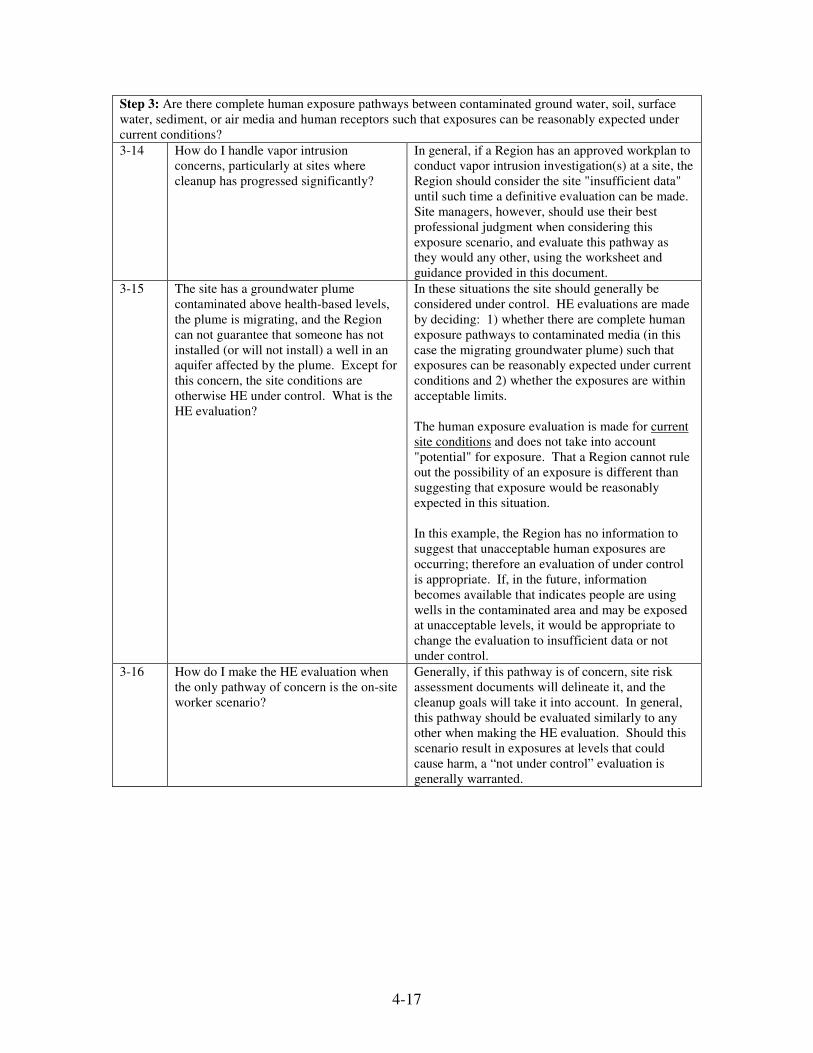
3-14 How do I handle vapor intrusion
concerns, particularly at sites where
cleanup has progressed significantly?
In general, if a Region has an approved workplan to
conduct vapor intrusion investigation(s) at a site, the
Region should consider the site "insufficient data"
until such time a definitive evaluation can be made.
Site managers, however, should use their best
professional judgment when considering this
exposure scenario, and evaluate this pathway as
they would any other, using the worksheet and
guidance provided in this document.
3-15 The site has a groundwater plume
contaminated above health-based levels,
the plume is migrating, and the Region
can not guarantee that someone has not
installed (or will not install) a well in an
aquifer affected by the plume. Except for
this concern, the site conditions are
otherwise HE under control. What is the
HE evaluation?
In these situations the site should generally be
considered under control. HE evaluations are made
by deciding: 1) whether there are complete human
exposure pathways to contaminated media (in this
case the migrating groundwater plume) such that
exposures can be reasonably expected under current
conditions and 2) whether the exposures are within
acceptable limits.
The human exposure evaluation is made for current
site conditions and does not take into account
"potential" for exposure. That a Region cannot rule
out the possibility of an exposure is different than
suggesting that exposure would be reasonably
expected in this situation.
In this example, the Region has no information to
suggest that unacceptable human exposures are
occurring; therefore an evaluation of under control
is appropriate. If, in the future, information
becomes available that indicates people are using
wells in the contaminated area and may be exposed
at unacceptable levels, it would be appropriate to
change the evaluation to insufficient data or not
under control.
3-16 How do I make the HE evaluation when
the only pathway of concern is the on-site
worker scenario?
Generally, if this pathway is of concern, site risk
assessment documents will delineate it, and the
cleanup goals will take it into account. In general,
this pathway should be evaluated similarly to any
other when making the HE evaluation. Should this
scenario result in exposures at levels that could
cause harm, a “not under control” evaluation is
generally warranted.
4-18
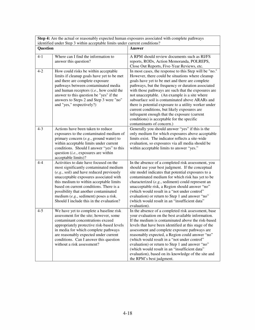
Step 4: Are the actual or reasonably expected human exposures associated with complete pathways
identified under Step 3 within acceptable limits under current conditions?
Question Answer
4-1 Where can I find the information to
answer this question?
A RPM should review documents such as RI/FS
reports, RODs, Action Memoranda, POLREPS,
Close Out Reports, Five-Year Reviews, etc.
4-2 How could risks be within acceptable
limits if cleanup goals have yet to be met
and there are complete exposure
pathways between contaminated media
and human receptors (i.e., how could the
answer to this question be "yes" if the
answers to Steps 2 and Step 3 were "no"
and "yes," respectively?)
In most cases, the response to this Step will be "no."
However, there could be situations where cleanup
goals have yet to be met and there are complete
pathways, but the frequency or duration associated
with those pathways are such that the exposures are
not unacceptable. (An example is a site where
subsurface soil is contaminated above ARARs and
there is potential exposure to a utility worker under
current conditions, but likely exposures are
infrequent enough that the exposure (current
conditions) is acceptable for the specific
contaminants of concern.)
4-3 Actions have been taken to reduce
exposures to the contaminated medium of
primary concern (e.g., ground water) to
within acceptable limits under current
conditions. Should I answer “yes” to this
question (i.e., exposures are within
acceptable limits)?
Generally you should answer “yes” if this is the
only medium for which exposures above acceptable
limits exist. The indicator reflects a site-wide
evaluation, so exposures via all media should be
within acceptable limits to answer “yes.”
4-4 Activities to date have focused on the
most significantly contaminated medium
(e.g., soil) and have reduced previously
unacceptable exposures associated with
this medium to within acceptable limits
based on current conditions. There is a
possibility that another contaminated
medium (e.g., sediment) poses a risk.
Should I include this in the evaluation?
In the absence of a completed risk assessment, you
should use your best judgment. If the conceptual
site model indicates that potential exposures to a
contaminated medium for which risk has yet to be
characterized (e.g., sediment) could represent an
unacceptable risk, a Region should answer “no”
(which would result in a “not under control”
evaluation) or return to Step 1 and answer “no”
(which would result in an “insufficient data”
evaluation).
4-5 We have yet to complete a baseline risk
assessment for the site; however, some
contaminant concentrations exceed
appropriately protective risk-based levels
in media for which complete pathways
are reasonably expected under current
conditions. Can I answer this question
without a risk assessment?
In the absence of a completed risk assessment, base
your evaluation on the best available information.
If the medium is contaminated above the risk-based
levels that have been identified at this stage of the
assessment and complete exposure pathways are
reasonably expected, a Region could answer “no”
(which would result in a “not under control”
evaluation) or return to Step 1 and answer “no”
(which would result in an “insufficient data”
evaluation), based on its knowledge of the site and
the RPM’s best judgment.

4-19
Step 4: Are the actual or reasonably expected human exposures associated with complete pathways
identified under Step 3 within acceptable limits under current conditions?
4-6 What risk “limits” should be used to
make this evaluation? Should we use 10-6
or 10-4
excess lifetime cancer risk?
Base your evaluation on the risk limits being used
for risk-based decisions at the site. For sites with a
ROD, generally use the risk value used to establish
cleanup levels. If a ROD has not been signed,
generally use the protocol typically applied in the
Region for pre-ROD sites (e.g., use state ARARs,
NCP risk range, etc.). If the appropriate risk limit is
uncertain, return to Step 1 and answer “no” (which
would result in an “insufficient data” evaluation).
4-7 How do I answer this question if the
human health risks from exposure to
some contaminants are above acceptable
limits and others are within acceptable
limits?
If the potential exposures to any contaminant
represent an unacceptable human health risk, a
Region should answer “no” to this question (which
would result in a “not under control” evaluation).
4-8 The exposures to individual contaminants
are within acceptable limits under current
conditions; however, cumulative risks
under current conditions are above
acceptable limits. Should I use single
contaminant or cumulative risk as the
basis for this evaluation?
Generally base your evaluation on the approach
being used for risk-based decisions at the site. For
example, if remedial actions to address current
exposures are being driven by an assessment of
cumulative risk, a Region should base its evaluation
on the cumulative effects of exposure to multiple
stressors.
4-9 The risks vary depending on the exposure
assumptions and the approach used to
estimate the exposure point
concentrations. What approach should be
used to assess the risk from potential
exposures to evaluate this EI?
A RPM may use the same exposure assumptions
and approach to determining exposure point
concentrations as are used in the risk assessment for
the site – a Region does not need to create new
information.
4-10 If the only unacceptable exposures for the
entire site (all media) are associated with
the “trespasser” scenario, should I still
answer “no” to this question?
If exposures are not within acceptable limits for any
scenario, based on current conditions you should
answer “no.”
4-11 At present, contamination in drinking
water wells does not present an
unacceptable risk, but contaminant
concentrations could be rising. What is
the correct evaluation?
In general, a Region would answer “yes” now and
change the response to “no” if and when the
contaminant concentrations reach a level such that
exposure would represent an unacceptable risk.
Regions should take appropriate response actions to
prevent exposure if the rising contaminant
concentrations threaten drinking water supplies
(e.g., provide alternative water supply).
4-12 The exposure scenarios driving the
remedy, as presented in the ROD, are
based on future land or ground water use
conditions that are different than current
use conditions. Should I base the
response to this step on current use
scenarios that are not driving the remedy?
Yes. Use exposure scenarios that consider current
use, as developed in the baseline risk assessment, to
make this evaluation.
4-13
What should I do if, after completing the
HE EI for a site, the degree of risk based
on current conditions is reevaluated as we
gain a better understanding of the site?
If the degree of risk is reevaluated based on new
data, consider whether the change would effect the
HE EI evaluation for the site. If so, update the EI
evaluation to reflect the new information.

4-20
Step 4: Are the actual or reasonably expected human exposures associated with complete pathways
identified under Step 3 within acceptable limits under current conditions?
4-14 What should I do if the cleanup standards
used to make the HE EI evaluation for my
site change (e.g. the promulgated
maximum contaminant level for
groundwater is changed).
In these cases review the revised standard and re-
assess the HE evaluation to decide whether the
contaminants are within acceptable limits for
current conditions. The HE evaluation should be
consistent with the new standard and should be
revised as appropriate if the revised standard
changes your evaluation of protectiveness.
4-15 How do I determine whether human
exposures associated with complete
pathways are within acceptable limits if
the nature of the exposure differs from
that evaluated in the baseline risk
assessment? For example, recent
information indicates that trespassing is a
problem at my site, but the exposure
pathways evaluated in the baseline risk
assessment assume a 30-year residential
use scenario.
In cases such as these, a Region should ensure that
the contaminant levels of concern are appropriate
for the specific exposure scenario that affects your
Human Exposure evaluation. For example, the
concentration levels of concern for a 30-year
residential use scenario will generally be lower than
those that would pose an unacceptable risk for
trespassing. In such situations infrequent trespassing
would generally not result in an evaluation of
human exposure not under control. However,
where evidence suggests that trespassing is frequent
or where it results in exposure pathways that were
not identified in the risk assessment documents for
the site (e.g., the risk data deal with dermal
exposure but not inhalation) a Region should
consult a risk assessor and work to identify
contaminant levels of concern specific to the
pathway in question.
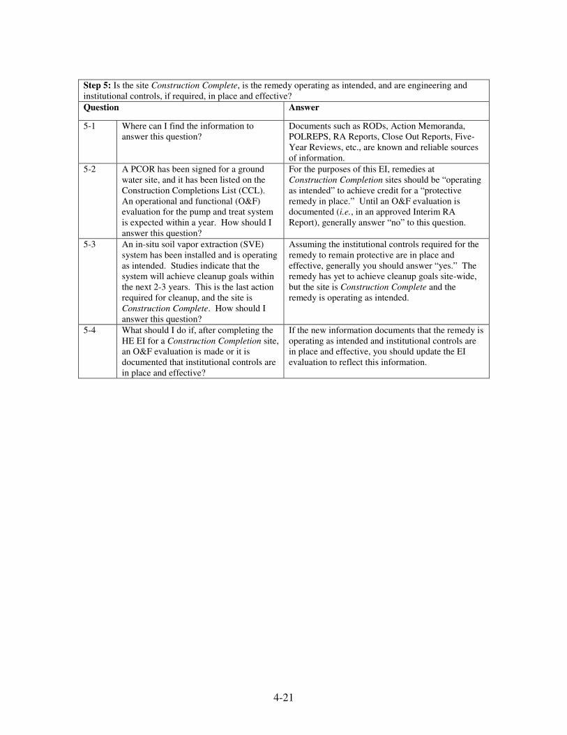
4-21
Step 5: Is the site Construction Complete, is the remedy operating as intended, and are engineering and
institutional controls, if required, in place and effective?
Question Answer
5-1 Where can I find the information to
answer this question?
Documents such as RODs, Action Memoranda,
POLREPS, RA Reports, Close Out Reports, Five-
Year Reviews, etc., are known and reliable sources
of information.
5-2 A PCOR has been signed for a ground
water site, and it has been listed on the
Construction Completions List (CCL).
An operational and functional (O&F)
evaluation for the pump and treat system
is expected within a year. How should I
answer this question?
For the purposes of this EI, remedies at
Construction Completion sites should be “operating
as intended” to achieve credit for a “protective
remedy in place.” Until an O&F evaluation is
documented (i.e., in an approved Interim RA
Report), generally answer “no” to this question.
5-3 An in-situ soil vapor extraction (SVE)
system has been installed and is operating
as intended. Studies indicate that the
system will achieve cleanup goals within
the next 2-3 years. This is the last action
required for cleanup, and the site is
Construction Complete. How should I
answer this question?
Assuming the institutional controls required for the
remedy to remain protective are in place and
effective, generally you should answer “yes.” The
remedy has yet to achieve cleanup goals site-wide,
but the site is Construction Complete and the
remedy is operating as intended.
5-4
What should I do if, after completing the
HE EI for a Construction Completion site,
an O&F evaluation is made or it is
documented that institutional controls are
in place and effective?
If the new information documents that the remedy is
operating as intended and institutional controls are
in place and effective, you should update the EI
evaluation to reflect this information.

4-22
4.4 ENTERING EXPOSURE DESCRIPTIONS IN THE JUSTIFICATION FIELD IN
CERCLIS
EPA has committed to providing current human exposure evaluations to the public
via its Superfund Site Profiles available on the internet. As part of this effort, the
Agency will provide descriptions of situations where a site is categorized as
“Insufficient Data” or “Not Under Control.” This information will be derived from
CERCLIS. Consequently, it is critical Regions maintain the quality of the
“justification” descriptions in the CERCLIS data base.
When making a Human Exposure Not Under Control or Insufficient Data evaluation in
CERCLIS, Regions must record exposure descriptions in the "Justification" field in order
to save the evaluation as draft. The purpose of this approach is to provide the public with
a succinct and clear description of why a site is so listed, along with information about
the steps EPA plans to take to address the exposures. Upon OSRTI review and approval
of the justification text, the human exposure evaluation will be saved in CERCLIS as
final.
To help standardize the descriptions entered into CERCLIS, and to assure that similar
exposure scenarios are described consistently across Regions, the templates below should
be used when populating the “Justification” field. The information entered in this field
will appear on the publicly available Superfund Site Progress Profiles Webpage, so it
should be accurate, updated when necessary, and contain the information outlined below.
General Template for Sites with an HE Evaluation of Not Under Control
The [insert site name] Superfund site is considered “Current Human Exposure Not Under
Control” because [insert a detailed description of the current completed human exposure
pathway(s) not under control; include the contaminants of concern and media].
As of _______ (date) the planned activities to address this pathway are [_______].
[As appropriate, add:
In addition, EPA (or state, or PRP or Federal Agency as appropriate) is currently [insert
summary descriptions of actions underway to address human exposures. (Include any
temporary controls that have been put in place to address this exposure scenario e.g., fish
advisory, fencing, signs)]
4-23
Example:
The Site X Superfund site is considered “Current Human Exposure Not Under Control”
because residents and recreational users of the creek can be exposed through direct
contact to arsenic and lead contaminated soils and sediments.
As of July 2007, the planned activities to address this pathway are continuation of
ongoing removal of arsenic and lead contaminated soils.
EPA has already begun cleaning up the contaminated soil. Removal actions started in
April 2007. Temporary fences to prevent access to the site were installed in May 2007.
Warning signs identifying the area as a Superfund site were posted in June 2007.
General Template for New Sites with an HE Evaluation of Insufficient Data:
As of [insert date] there is insufficient information to determine the site-wide Human
Exposure Control status at [insert site name] Superfund Site.
[Provide general context for why there is insufficient data at the site. An example:
[Insert site name] was [proposed/finalized] for the NPL on MM/DD/YY, and there has
been no evaluation of the human health exposure indication yet. This does not
necessarily mean that unacceptable exposures are occurring.]
As of _______ (date) the planned activities to collect sufficient information to make a
human exposure evaluation are [_______].
[As appropriate add the following:
In addition, EPA (or state, or PRP or Federal Agency as appropriate) is currently [insert
descriptions of actions underway to address human exposures. (Include any temporary
controls that have been put in place to address this exposure scenario e.g., fish advisory,
fencing, signs)]
General Template for Longer Term Cleanups with a Newly Identified Exposure
Pathway and/or Contaminant(s):
As of [insert date] there is not sufficient information available to determine the site-wide
Human Exposure Control status at X Superfund Site because of a newly identified
potential exposure pathway and/or contaminant(s) [insert a detailed description of the
human exposure pathway of concern, include the contaminants of concern and media].
4-24
The activities planned to make the HE evaluation include [_______] (list whatever
activity is necessary to make the evaluation: e.g., data needed, conduct sampling, monitor
basements for vapor intrusion, complete risk assessment, and conduct well surveys).
[As appropriate, add the following:
In addition, EPA (or state, or PRP or Federal Agency as appropriate) is currently [insert
summary of actions underway to address human exposures. (Include any temporary
controls that have been put in place to address this exposure scenario e.g., fish advisory,
fencing, signs)]
4.5 RELATIONSHIP OF THE HUMAN EXPOSURE MEASURE TO CROSS PROGRAM
REVITALIZATION MEASURES
The new Cross Program Revitalization Measures (CPRM) for Superfund and federal
facilities include two performance measures: Protective for People Under Current
Conditions (PFP), and Ready for Anticipated Use (RAU). Regions will use Human
Exposure Under Control criteria in order to make the evaluation that a site or operable
unit (OU) is PFP and inform whether the site or operable unit is also RAU.
The PFP measure reports sites and acres at which there is no complete pathway for
human exposures to unacceptable levels of contamination, based on current site
conditions. In order to do this, Regions should apply the Human Exposure Under Control
criteria on an OU basis at all sites included in the CPRM Universe. Therefore, there will
be sites with acres meeting the PFP performance measure that are not Human Exposure
Under Control at the entire site, because the PFP performance measure is measured on an
OU basis.
A site or OU will achieve the PFP performance measure when it can be determined that
the entire site or OU meets any one of the three possible designations for Human
Exposure Under Control:
• Current Human Exposures Under Control; or
• Current Human Exposures Under Control and protective Remedy or Remedies in
Place; or
• Current Human Exposures Under Control and Long-Term Human Health
Protection Achieved.
In order for a site or OU to meet the Ready for Anticipated Use (RAU) measure, it must
be PFP (and therefore meets the Human Exposure Under Control criteria on either an OU
or site-wide basis) in addition to meeting the following criteria:
4-25
• All cleanup goals are achieved for media that may affect current and reasonably
anticipated future land uses, or have documented uncontaminated areas, so that
there are no unacceptable risks; and
• All institutional or other controls, identified as part of the response action as
necessary for the site's long-term protection, are properly in place.
For more information, please refer to the Superfund and Federal facilities CPRM
guidance, Guidance for Documenting and Reporting Performance in Achieving Land
Revitalization, OSWER 9200.1-74.
4.6 RELATIONSHIP OF THE HUMAN EXPOSURE MEASURE TO FIVE-YEAR REVIEWS
Consistent with CERCLA and the National Contingency Plan (NCP), remedial actions
that allow contaminants to remain on site above levels that allow for unlimited use and
unrestricted exposure undergo review at least every five years to determine whether the
remedy is or will be protective of human health and the environment. Among other
things, these reviews assure that the remedy is functioning as intended, that the exposure
assumptions, toxicity data, and cleanup goals are still valid, and assess whether any new
information has been discovered that could call into question the protectiveness of the
remedy.
Many of the activities required to make a five-year review protectiveness evaluation (e.g.,
addressing newly promulgated standards, confirming current and expected land use,
identifying new contamination or contaminant sources) are useful in confirming the
human exposure status.
Upon completion of any five-year review, Regions should confirm that the information
evaluated in the review is consistent with the current site-wide human exposure
evaluation. If necessary, Regions should revise human exposure evaluations in
CERCLIS to be consistent with the information evaluated during the five-year review.
Note that human exposure evaluations describe risks to human health under current
conditions, and do not address potential/future human health risks or ecological risks.
Five-year reviews do not always address the entire site, may consider potential/future
risks, and may also address ecological risks. Because of this, five-year review
protectiveness statements and human exposure evaluations are not direct corollaries.
For assuring consistency between five-year reviews and human exposure evaluations, the
information used to develop protectiveness statements is generally more useful than the
protectiveness category itself.
For a detailed explanation of and guidance on conducting five-year reviews, please see
"Comprehensive Five-Year Review Guidance" (OSWER 9355.7-03B-P, June 2001).
5-1
5.0 MIGRATION OF CONTAMINATED GROUND WATER UNDER
CONTROL EI
The GM EI typically documents whether contamination is below protective, risk-based
levels or, if not, whether the migration of contaminated ground water is stabilized and
there is no unacceptable discharge to surface water and monitoring will be conducted to
confirm that affected ground water remains in the original area of contamination. This
indicator normally is limited to sites with known ground water contamination6.
A conclusion of “migration of contaminated ground water under control” generally
indicates that all information on known and reasonably expected ground water
contamination has been reviewed and the above conditions are met.
5.1 EVALUATING THE MIGRATION OF CONTAMINATED GROUND WATER UNDER
CONTROL
Regions should consider the following recommended guidelines when evaluating the GM
environmental indicator:
• Sites with past or present ground water contamination should be evaluated. Data
for sites where ground water was previously contaminated but has been cleaned
up should be evaluated to ensure that the indicator accurately records program
progress.
• This evaluation should be made on a site-wide basis, looking at distinct plumes
across the entire site.
• The evaluation should be made with “reasonable certainty” (i.e., based on the
most current data for the site). Documents such as RODs, Action Memoranda,
POLREPS, Five-year Reviews, periodic ground water and surface water
monitoring reports, and Close Out Reports are good sources of data and often
provide sufficient information. As new data become available, the evaluation can
be revised.
6 Prior to the publication of this guidance, GM determinations were made only for Superfund final and
deleted National Priorities List (NPL) sites. Beginning in fiscal year (FY) 2008, Regions should expand
their determinations to include proposed NPL sites and Superfund Alternative (SA) Sites. Results for these
site categories will be reported separately. Regions should enter groundwater determinations into
CERCLIS before the end of FY 2008, and update these determinations thereafter consistent with this
guidance. For SA Sites, the GM determination should apply only to those sites that are actively using the
Superfund Alternative approach. These are non-NPL sites with a signed, enforceable agreement for RI/FS,
RD, RA or NTCRA finalized after June 2002 where: (a) the agreement contains the SA provisions or has
prior written approval to omit the provisions, or (b) the agreement is consistent with EPA SA guidance.
For more information regarding SA determinations, consult "Revised Response Selection and Settlement
Approach for Superfund Alternative Sites (OSWER 9208.0-18, June 2004).
5-2
• The evaluation should be based on the existing plume boundary (not property
boundary or projected exposure point).
• Ongoing monitoring should consider both stabilization of migration and impacts
to surface water by contamination.
• Limited migration may be consistent with a conclusion that “contaminated ground
water migration is under control” if the contaminant migration is associated with a
formal natural attenuation remedy.
Regions should use the step-by-step process and worksheet on the following pages to
evaluate the GM EI.

5-3

5-4
Recommendations for completing the worksheet and entering/selecting responses enter
into CERCLIS are as follows:
(Step 1) Evaluate whether, based on the most current site data, all available
relevant/significant information on known and reasonably suspected releases to the
ground water has been considered in this EI evaluation.
- If all available relevant/significant information has not been considered,
reevaluate existing data.
- If data are unavailable or are insufficient for this evaluation, select
“Insufficient Data” in CERCLIS.
- If all available relevant/significant information has been considered and is
sufficient, proceed to Step 2.
Tips for completing rationale:
- “Current data for the site” should be those that describe conditions that are
known or suspected at the time the EI evaluation is conducted.
- Review and consider information that is pertinent to the evaluation of
contaminated ground water migration. Consider all available sources,
even if you decide to base the indicator evaluation on one source or a
subset of sources.
(Step 2) Evaluate whether ground water is known or reasonably suspected to be
“contaminated” above appropriately protective risk-based “levels” (applicable
promulgated standards, as well as other appropriate standards, guidelines, or criteria).
- If ground water is not known or reasonably suspected of being
contaminated above appropriately protective risk-based levels, site meets
definition of ”contaminated ground water migration under control.” Select
“No” in CERCLIS.
- If ground water is known or reasonably suspected of being contaminated
above appropriately protective risk-based levels, proceed to Step 3.
- If insufficient data are available, select “Insufficient Data” in CERCLIS.
5-5
Tips for completing rationale:
- “Contaminated” refers to concentrations of contaminants that exceed
appropriately protective risk-based levels such as chemical-specific
Applicable or Relevant and Appropriate Requirements (ARARs) or
health-based levels developed in a risk assessment or Record of Decision.
- All contaminants of potential concern present at the site above risk-based
screening levels should be considered for sites without a ROD. For sites
with a ROD, Regions should consider contaminants of concern identified
in the Risk Assessment.
(Step 3) Evaluate whether the migration of contaminated ground water is stabilized
(such that contaminated ground water is expected to remain within “existing area of
contaminated ground water”) as defined by the monitoring locations designated at the
time of this evaluation.
- If contaminated ground water migration is not stabilized, site does not
meet definition of ”contaminated ground water migration under control.”
Select “No” in CERCLIS.
- If contaminated ground water migration is stabilized, proceed to Step 4.
- If insufficient data are available, select “Insufficient Data” in CERCLIS.
Tips for completing rationale:
- The “existing area of contamination” is an area (with horizontal and
vertical dimensions) that has been verifiably demonstrated to contain all
relevant ground water contamination associated with this evaluation, and
is defined by designated locations proximate to the outer perimeter of
“contamination” that can and will be monitored in the future to physically
verify that all “contaminated” ground water remains within this area.
- Evaluation of plume stability is based on expectations that the plume will
remain in the “existing area of contaminated ground water” and should
consider all available data. For Pump and Treat (P&T) remedies, the
evaluation should be based on multiple lines of evidence for ground water
capture (see Elements for Effective Management of Operating Pump and
Treat Systems (Publication 9355.4-27FS-A, December, 2002).
- If monitored natural attenuation (MNA) is the selected remedy for the site,
it can be concluded that “contaminated ground water migration is under
control” if post-selection monitoring results are consistent with the
assumptions used to support the MNA remedy selection (see Section 5.2).
5-6
(Step 4) Evaluate whether “contaminated” ground water discharges into surface water
bodies.
- If contaminated ground water does not discharge into surface water,
proceed to Step 6.
- If contaminated ground water does discharge into surface water, proceed
to Step 5.
- If insufficient data are available, select “Insufficient Data” in CERCLIS.
Tips for completing rationale:
- “Surface water bodies” include lakes, rivers, estuaries, etc., and related
sediment and ecosystems.
- Regions should base their answers for this step on hydraulic information,
considering contaminant information only to the extent that it
demonstrates with reasonable certainty that there is no hydraulic
connection between the contaminated ground water and surface water.
- Regions should consider both constant and intermittent (e.g., seasonal)
discharges – any expected discharge, constant or intermittent, should
result in a conclusion for the purposes of completing this EI that ground
water discharges to surface water.
(Step 5) Evaluate whether the discharge of “contaminated” ground water into surface
water can be shown to be “currently acceptable” (i.e., not cause unacceptable impacts to
surface water, sediments, or ecosystems that should not be allowed to continue until a
final remedy decision can be made and implemented).
- If the discharge is not “currently acceptable,” the site does not meet
definition of ”contaminated ground water migration under control.” Select
“No” in CERCLIS.
- If the discharge is “currently acceptable, proceed to Step 6.
- If insufficient data are available, select “Insufficient Data” in CERCLIS.
Tips for completing rationale:
- Regions should consider surface water, sediments, and ecosystems to
determine whether unacceptable impacts exist at the site.
- Assessment and measurement endpoints should be the same as those being
used to make risk management decisions for the site.
- Aquifer contaminant levels identified or developed specifically for the
protection of surface water may be used for this evaluation.
5-7
(Step 6) Identify whether ground water monitoring/measurement data (and surface
water/sediment/ecological data, as necessary) will be collected in the future to verify that
contaminated ground water has remained within the horizontal (or vertical, as necessary)
dimensions of the “existing area of contaminated ground water.”
- If monitoring/measurement data will not be collected, site does not meet
definition of ”contaminated ground water migration under control.” Select
“No” in CERCLIS.
- If monitoring/measurement data will be collected, site meets definition of
”contaminated ground water migration under control.” Select “Yes” in
CERCLIS.
- If insufficient data are available, select “Insufficient Data” in CERCLIS.
Tips for completing rationale:
- Regions should review ground water and surface water monitoring reports
on a regular basis (i.e., at the same frequency as monitoring - e.g.,
quarterly, annually, etc.) and compare to historical data to evaluate the
status of the EI evaluation.
- To conclude that “contaminated ground water migration is under control,”
monitoring should be required to verify that the ground water
contamination remains within the “existing area of contaminated ground
water” and ensure that surface water impacts remain acceptable, if
applicable.
- This question is focused on the future. Regions should consider whether
there are plans for monitoring, not whether monitoring has been
completed in the past. “Plans for monitoring” will usually be documented
in the remedy decision (e.g., ROD), remedial design, Interim RA, PCOR,
or similar document.
Data entry instructions for assigning a value to the GM indicator in CERCLIS are
discussed in Appendix B.

5-8
5.2 CONSIDERING MONITORED NATURAL ATTENUATION REMEDIES
A conclusion that “contaminated ground water migration is under control” is possible for
sites where Monitored Natural Attenuation (MNA) is the selected remedy for
contaminated ground water. Decisions to employ MNA as the sole remedy or a
component of the remedy should be thoroughly and adequately supported with site-
specific characterization and analysis. MNA should not be used when it would result in
plume migration or unacceptable impacts to environmental resources.
EPA recognizes that a plume boundary may be more realistically defined by a zone rather
than a line. Fluctuations within this zone are likely to occur due to a number of factors
(e.g., analytical, spatial, or seasonal variability), which may or may not be indicative of a
trend in plume migration. Limited plume migration can be acceptable as part of the MNA
remedy and, if it is determined that such migration does not indicate a trend, it can be
concluded that “contaminated ground water migration is under control” where other
conditions for this conclusion are met. However, if post-selection monitoring results
suggest that the contamination is not attenuating as expected, the remedy decision may
need to be reviewed; a conclusion that “contaminated ground water migration is under
control” may not be possible.
5.3 INFORMATION UPDATE AND REPORTING REQUIREMENTS
Regions should complete a copy of the recommended GM EI worksheet in CERCLIS
after a site is first listed as Final on the NPL (data can first be entered when the site is
Proposed), and update the GM EI as soon as a change in the evaluation is appropriate. At
a minimum, data updates should occur by the 5th working day in October of each year.
Changes in EI Status
Update CERCLIS within 30 days of knowing that the EI status has changed.
No Change in EI Status
If there is no change in the status of the GM EI, Regions should update “Last Review
Date” in CERCLIS for appropriate indicator on the Site Characterization Screen.
New Listings on the NPL
For sites that are placed on the NPL, update CERCLIS within one year of NPL site listing
as Final.

5-9
5.4 FREQUENTLY ASKED QUESTIONS – MIGRATION OF CONTAMINATED GROUND
WATER UNDER CONTROL
Step 1: Based on the most current site data, has all available relevant/significant information on known and
reasonably suspected releases to the ground water been considered in this EI evaluation?
Question Answer
1-1 What are the best sources of information
for me to consider for this EI evaluation?
Documents such as RI/FS reports, RODs, Action
Memoranda, POLREPS, Close Out Reports, annual
or periodic ground water and surface water
monitoring reports, Five-Year Reviews, etc., are
good sources of information.
1-2 No known ground water contamination
exists at the site. Do I need to evaluate
this EI?
Do not consider this EI if no known or suspected
ground water contamination exists or has existed in
the past at the site. If ground water contamination is
known or suspected or if contamination once was
present but has since been cleaned up, you should
complete all appropriate steps for this evaluation.
1-3 There may be several different sources of
information (e.g., State, EPA, PRP). Do I
need to be familiar with all of this
information to answer this question?
You should be familiar with that information that is:
1) pertinent to evaluation of migration of
contaminated ground water; and 2) available to you.
If the information from other sources is both
relevant and available to you, generally you should
consider the contents of this information for this
evaluation.
1-4 What if a PRP has drawn different
conclusions than EPA regarding the status
of contaminated ground water migration?
Do I need to consider the PRP’s data?
Generally, yes. However, you can decide what
weight to place on the PRP’s data when determining
whether they will be useful for evaluating migration
of contaminated ground water for this EI.
1-5 What if I am aware of information that
another Agency or a PRP has collected
but cannot obtain a copy of it?
If the information is not available for your review,
you should not consider this information in
evaluating the sufficiency of available information
to respond to this EI.
1-6 The site investigation is in the early
stages and it is unknown whether the
plume is naturally attenuating (i.e.,
contained). How should I answer this
question?
If data are unavailable or insufficient to evaluate the
GM EI, you should answer “data incomplete” and
select “Insufficient Data” in CERCLIS.
1-7 The pump and treat remedy has been
operating for only a short time, and it is
unknown whether the plume has been
captured. How should I answer this
question?
If data are unavailable or insufficient to evaluate the
GM EI, answer “data incomplete” and select
“Insufficient Data” in CERCLIS.
1-8 How is a “no” answer for Step 1 recorded
in CERCLIS?
You should answer either “yes” or “insufficient
data” in Step 1. If you answer “no,” you should
reevaluate the available data to complete an
evaluation for this EI.
5-10
Step 2: Is ground water known or reasonably suspected to be “contaminated” above appropriately
protective risk-based levels as a result of a release from the site?
Question Answer
2-1 Where can I find the information to
answer this question?
Documents such as RI/FS reports, RODs, Action
Memoranda, POLREPS, Close Out Reports, annual
or periodic ground water and surface water
monitoring reports, Five-Year Reviews, etc., are
good sources of information.
2-2 What risk-levels should I use to evaluate
this step?
Generally you should use risk levels that are
consistent with the most recent stage of the response
action. Risk-based levels such as chemical-specific
Applicable or Relevant and Appropriate
Requirements (ARARs) or health-based levels
developed in a risk assessment or Record of
Decision are appropriate.
2-3 How should I interpret whether ground
water is “reasonably suspected” to be
contaminated if my sampling data are
limited?
In the absence of extensive sampling and analytical
data, you should use your best judgment. If
evidence–even limited evidence–indicates that there
is a reasonable possibility of ground water
contamination, you should answer either “yes” or
“insufficient data.” The EI requires that you make
your evaluation with “reasonable certainty.”
2-4 How do I answer this question if some
ground water contaminant levels are
below their respective risk-based levels
and others are above?
If the concentration of any contaminant in ground
water exceeds its appropriately protective risk-based
level, you should answer “yes” to this question.
2-5 Does a single “hit” of contamination
mean that I should answer “yes” to this
question?
Generally you should base your evaluation on the
information and approach being used for risk-based
decisions at the site. If you are in the early stages of
the investigation, with limited data, a single hit may
be enough to draw a “yes” conclusion if multiple
lines of evidence corroborate this conclusion.
Generally you should use professional judgment to
evaluate this question with reasonable certainty. If
data do not allow you to make a judgment with
reasonable certainty, you should answer
“insufficient data” to this question.
2-6 Should I use average, UCL on the mean,
or another type of concentration when
answering this question?
Generally you should base your evaluation on the
information and approach being used for risk-based
decisions at the site. If you are at a later stage in
the cleanup process and the UCL is being used as
the exposure point concentration, you should use
this to answer this question.
2-7 How should I answer this question if the
contaminant levels are above Preliminary
Remediation Goals (PRGs) but below
final cleanup levels?
Generally you should use the risk-based levels that
are consistent with the most recent stage of the
response action. If final cleanup levels are the most
recent risk-based numbers, you should base your
answer on final cleanup levels. If PRGs are the
most recent risk-based levels, you should base your
answer on PRGs.

5-11
Step 2: Is ground water known or reasonably suspected to be “contaminated” above appropriately
protective risk-based levels as a result of a release from the site?
2-8 If more than one distinct contaminated
plume exists at a site, should I make the
evaluation based on only one plume or
multiple plumes?
If more than one distinct plume exists at a site and
only one plume contains contaminants above risk-
based levels, generally you should answer “yes” to
this question and continue with step 3. Ultimately,
if you determine migration of contaminated ground
water plume is under control for one plume but not
another, the site does not meet the definition of
“contaminated ground water migration under
control.” Generally you should answer “no” in
CERCLIS if any plume does not meet the definition
as defined in steps 2-6.
2-9 If multiple distinct plumes exist at the
site, do I consider each plume separately?
Generally you should evaluate each plume
separately, to the extent that the plumes can be
separately identified. If you answer “yes” for a
ground water plume in this step, you should
continue to step 3 (and subsequent steps, if
applicable) for that plume. If you answer “no” for a
plume in this step, this plume can be dropped from
further consideration under this EI. Ultimately, if
you determine migration of contaminated ground
water plume is under control for one plume but not
another, the site does not meet the definition of
“contaminated ground water migration under
control.”
2-10 What should I do if the risk-based levels
that I used to answer this question change
as we learn more about the site?
If risk-based levels change, you should consider
whether the change would effect the GM EI
evaluation for the site. If so, you should update the
EI evaluation to reflect the new information.
2-11 What should I do if the Contaminants of
Concern (COCs) in ground water change
or contaminant concentrations are
reevaluated as we learn more about the
site?
If COCs in ground water change or contaminant
concentrations are reevaluated based on new data,
generally you should consider whether the change
would effect the EI evaluation for the site. If so,
you should update the EI evaluation to reflect the
new information.
Step 3: Is the migration of contaminated ground water stabilized as defined by the monitoring locations
designated at the time of the evaluation?
Question Answer
3-1 Where should I find information to
answer this question?
Documents such as RI/FS reports, RODs, Action
Memoranda, POLREPS, Close Out Reports, annual
or periodic ground water and surface water
monitoring reports, Five-Year Reviews, etc., are
good sources of information.
5-12
Step 3: Is the migration of contaminated ground water stabilized as defined by the monitoring locations
designated at the time of the evaluation?
3-2 If monitored natural attenuation has been
selected as the remedy for a site, can I
answer “yes” to this question?
Monitored natural attenuation does not preclude you
from answering “yes” to this question. If the
selected remedy is monitored natural attenuation
and the plume meets conditions set forth in steps 1-
3, you should answer “yes” to this question and
proceed to step 4.
3-3 If one monitoring location shows a single
“hit” of a contaminant of concern, should
I answer “no” to this question?
Generally, the evaluation that migration has
stabilized will require consideration of site
characteristics and multiple rounds of sampling to
assess any trends. A single “hit” should be
considered in the context of these other data. If the
data are limited, you should use your best
professional judgment to answer the question with
reasonable certainty. If uncertainty persists, you
should answer “insufficient data.”
3-4 How is the “existing area of
contamination” determined?
The existing area of contamination is defined by
designated locations proximate to the outer
perimeter of contamination that can and will be
monitored in the future to physically verify that all
contamination remains in this area. Note that
monitoring wells used to make this evaluation
should be located inside the area of contamination
(they do not have to be “clean” wells). You do not
need to continue to monitor wells that show
consistently low levels of contamination solely for
the purposes of this EI. Generally you should use
the data that you would normally collect to monitor
site conditions when evaluating this EI.
3-5 I have very limited data on which to
judge the stability of the plume. Can I
answer “insufficient data” to this
question? What is “sufficient?”
Generally, yes, you should answer “insufficient
data” in such an instance. Each site is unique, so
there is no common definition of “sufficiency.”
You should use your best professional judgment and
determine your answers based on “reasonable
certainty.”
3-6 Evidence indicates contamination beyond
the existing area, but the contamination is
below risk-based levels. How would this
question be answered for this scenario?
Contamination levels outside of the area of
contamination need not exceed risk-based levels to
show migration of the plume. If contamination has
been identified outside of the existing area of
contamination, you should consider all of the
information available, including capture zone
analyses (for P&T remedies) and use your best
judgment to assess whether migration of the plume
is stabilized.
5-13
Step 3: Is the migration of contaminated ground water stabilized as defined by the monitoring locations
designated at the time of the evaluation?
3-7 Only some contaminants (Contaminants
of Potential Concern (COPC) or non-
COPCs) associated with a site were
detected outside the area of existing
contamination. Should I consider the
plume not stable?
Any contaminant–COPC or non-COPC– associated
with the ground water plume that has migrated
beyond the area of existing contamination could be
an indication that the plume is not stabilized.
Generally you should consider all available
analytical and hydraulic information and use your
best judgment to assess whether migration of the
plume is stabilized.
3-8 Multiple plumes exist at a site. At least
one is stabilized. How do I record this for
this EI step?
The EI evaluation should be made on a site-wide
basis. If any plume for which you answered “yes”
in step 2 is not stable, the site does not meet the
definition of “contaminated ground water migration
under control.” Generally you should answer “no”
to this question.
3-9 What should I do if the COCs in ground
water change or contaminant
concentrations are reevaluated as we learn
more about the site?
If COCs in ground water change or contaminant
concentrations are reevaluated based on new data,
you should consider whether the change would
effect the EI evaluation for the site. If so, you
should update the EI evaluation to reflect the new
information.
3-10 What if monitoring locations change in
the future?
If monitoring locations for the existing area of
contamination change, you need not update this EI
unless contamination is found outside of the area of
contamination as determined by those monitoring
locations. If so, you should update the EI
evaluation to reflect the new information.

5-14
Step 4: Does contaminated ground water discharge into surface water bodies?
Question Answer
4-1 Where can I find the information to
answer this question?
Documents such as RI/FS reports, RODs, Action
Memoranda, POLREPS, Close Out Reports, annual
or periodic ground water and surface water
monitoring reports, Five-Year Reviews, etc., are
good sources of information.
4-2 If surface water data are limited (e.g., no
surface water samples have been
collected), how should I evaluate this
question?
In the absence of a complete characterization of the
ground water to surface water pathway, you should
use your best judgment. Ground water and
hydrological investigations collected during the RI
may provide enough information to evaluate this
question with “reasonable certainty.” You could
also consult the Conceptual Site Model (CSM) to
determine whether it would be reasonable to assume
ground water discharge. If no information is
available, you should answer either “no” or
“insufficient data.”
4-3 Ground water to surface water discharge
is not constant or is very sporadic.
Should I answer “yes” to this question?
If ground water has been documented to discharge
to surface water at any time, you should answer
“yes” to this question.
4-4 Ground water to surface water discharge
has been documented; however, sampling
did not show contamination in the surface
water at the discharge point. Therefore, I
cannot assume “contaminated” ground
water is discharging at this point. Should
I answer “no” to this question?
You should base your answer on “reasonable
certainty.” If you are reasonably certain no
contaminated ground water is discharging to surface
water, you should answer “no” to this question.
However, if you are unsure or your professional
judgment leads you to think contaminated ground
water is discharging to surface water (e.g.,
contamination exists at the ground water table just
upgradient of the surface water body), you should
answer “insufficient data” or “yes” based on your
level of certainty.
4-5 Multiple plumes exist at the site. Only
one plume discharges contamination into
a surface water body. How do I answer
this question?
The EI evaluation is made on a site-wide basis. If
contaminated ground water associated with a plume
for which you answered “yes” in step 3 discharges
into surface water, you should answer “yes” to this
question and answer question 5 for this plume.
4-6 Should future/past discharges be
considered when evaluating this
question?
Because ground water levels and discharge to
surface water can fluctuate throughout the year,
future or past discharges should be considered when
answering this question. If there is evidence of past
discharges, or likelihood of future discharges, you
should answer “yes” to this question regardless of
current conditions. If conditions change, preventing
future discharge you should answer “no” to this
question. (See question 4-7).

5-15
Step 4: Does contaminated ground water discharge into surface water bodies?
4-7 What if conditions change and a remedy
prevents future discharges?
Generally you should reevaluate the answer to this
question if conditions change. If a remedy
addresses contaminated ground water discharge into
surface water so that surface water is unlikely to
receive future ground water discharge, you should
answer “no” to this question.
Step 5: Can the discharge of contaminated ground water into surface water be shown to be currently
acceptable as defined (i.e., not cause unacceptable impacts to surface water, sediments, or ecosystems that
should not be allowed to continue until a final remedy decision can be made and implemented)?
Question Answer
5-1 Where can I find the information to
answer this question?
Documents such as RI/FS reports, RODs, Action
Memoranda, POLREPS, Close Out Reports, annual
or periodic ground water and surface water
monitoring reports, Five-Year Reviews, etc., are
good sources of information.
5-2 Should I use ground water contaminant
levels (identified in step 2) to determine if
discharge of contaminated ground water
to surface water is within currently
acceptable limits?
Generally, no. You should base your decision on
contaminant levels identified or developed
specifically for the protection of surface water (e.g.,
Ambient Water Quality Criteria (AWQC)).
Generally you should use those surface water
standards or other contaminant levels being used for
risk-based decisions for the site.
5-3 What if surface water contaminant levels
are above one standard, but below
another? How should I answer this
question?
Generally you should base your answer on the
standards being used for risk based decisions for the
site. If contaminant levels are above a standard that
has been deemed the “acceptable” level for a site,
you should answer “no” to this question.
5-4 Water quality standards (e.g., TMDLs,
AWQC) have not been developed for any
contaminants at the site. How should I
evaluate this question?
In the absence of water quality standards, you
should base your evaluation on the best available
information. If evidence suggests that ground water
discharge has resulted in unacceptable impacts on
surface water (e.g., if remedial actions are planned
for the surface water pathway), you should answer
“no” to this question.
5-5 At present, discharge of contaminated
ground water to surface water is
acceptable. Should I answer “yes” now
and change the response to “no” if and
when the surface water contaminant
concentrations reach a level such that the
surface water, sediment, or ecosystems
are negatively impacted?
Generally you should use your professional
judgment or consult the risk assessment for aid in
making this decision with reasonably certainty.
You should answer “no” only if future impacts to
surface water are imminent (i.e., are expected to
occur before remedial actions can be implemented).

5-16
Step 5: Can the discharge of contaminated ground water into surface water be shown to be currently
acceptable as defined (i.e., not cause unacceptable impacts to surface water, sediments, or ecosystems that
should not be allowed to continue until a final remedy decision can be made and implemented)?
5-6 The only contaminants detected in the
surface water are not present in the
ground water plume. If these
contaminants are above acceptable levels,
but might not be related to the ground
water plume, should I answer “yes?”
Generally you should use your professional
judgment and consider all aspects of the site,
including the extent of sampling conducted at the
time of evaluation, in order to determine the answer.
If the contaminants are clearly not related to ground
water, you should answer “yes” to this question and
continue with the worksheet.
5-7 Some contaminants in surface water are
at acceptable levels, others are not. How
should I answer this question?
If any contaminant associated with the discharge of
ground water is found in surface water above
acceptable limits, you should answer “no” to this
question.
5-8 Contaminants associated with ground
water discharge were found in sediment
samples at unacceptable levels, but not in
surface water samples. Is it appropriate
to answer “no” to this question if only
sediment contamination is found?
Generally, yes. Sediments should be considered
when evaluating this question. Past releases could
be “trapped” in sediments after surface water
contamination has been cleared. Because of this,
sediment contaminant levels may not correlate
directly with surface water contaminant levels. It is
conceivable that sediment contamination may be
measured even if surface water contamination is not
detected. Therefore, assuming the contamination
can be associated with present or past ground water
discharge (see questions 4-6 and 4-7), you should
answer “no” to this question.
5-9 How do I answer this question if
contaminant levels in surface
water/sediment/ecosystems have
decreased to acceptable limits?
If ground water discharge continues, yet surface
water contaminant levels are within currently
acceptable limits, you should answer “yes” to this
question and continue to step 6.
Step 6: Will ground water monitoring/measurement data (and surface water/sediment/ecological data, as
necessary) be collected in the future to verify that contaminated ground water has remained within the
horizontal (or vertical, as necessary) dimensions of the existing area of contaminated ground water?
Question Answer
6-1 Where can I find the information to
answer this question?
Documents such as RODs, Action Memoranda,
POLREPS, Close Out Reports, Five-Year Reviews,
etc., are good sources of information.
6-2 How should the existing area of
contaminated ground water be defined?
Generally you should define the existing area of
contaminated ground water consistent with step 3.
6-3 What if future monitoring shows
migration of the ground water plume?
Your answer to this step should be based only on
whether or not monitoring is planned for the future.
If the plume characteristics change in the future, the
EI should be reevaluated.

5-17
Step 6: Will ground water monitoring/measurement data (and surface water/sediment/ecological data, as
necessary) be collected in the future to verify that contaminated ground water has remained within the
horizontal (or vertical, as necessary) dimensions of the existing area of contaminated ground water?
6-4 Contaminated ground water discharges to
surface water at the site. However,
adverse surface water impacts have not
been shown from discharging
contaminated ground water. No future
monitoring is planned. Should I answer
“no” to this question, even if future
impacts to surface water are possible?
The decision not to monitor surface water suggests
that future impacts are unlikely; therefore, there is
no need to consider whether surface water
monitoring is planned when answering this
question. However, if future ground water
monitoring suggests changing conditions that could
result in surface water impacts, the EI evaluation
should be reconsidered.
6-5 No vertical dimensions have been
estimated for the plume. Does the future
monitoring need to consider vertical
dimension?
If vertical dimensions have not been established for
the existing area of contamination, future
monitoring does not need to consider vertical
dimensions in order for you to answer “yes” to this
step.
6-6 The ground water contamination has been
cleaned up and monitoring efforts are
ceasing. Should I answer “no” to this
question if EPA ceases monitoring in the
future?
If the site has been cleaned-up or otherwise
addressed, ground water will likely be below
protective risk-based levels. If this is the case, you
should answer “no” to step 2 and the site should
meet the definition of “migration of contaminated
ground water under control.”
6-7 Monitoring efforts are being halted (by
outside agency, state, etc.); however,
contamination still exists at the site. How
do I answer this question if site conditions
are thus changed?
If site conditions do not allow you to answer “no” to
step 2, you should continue with worksheet. In step
6, you need to evaluate your answer based on
current known decisions. If monitoring is being
ceased in the future, you should answer “no” to this
question.
Superfund Environmental Indicators Guidance
Human Exposure Revisions
APPENDICES - DATA VIEWING AND ENTRY
Office of Superfund Remediation and Technology Innovation
U.S. Environmental Protection Agency
Washington, D.C. 20460
March 2008

A-1
Appendix A – DATA VIEWING
The purpose of the data viewing section is to describe the methods used to view current
Environmental Indicator data in CERCLIS, and to identify and define each of the data
elements displayed on each screen. These data will serve as an effective tool to help the
Regions monitor their cleanup progress, support Government Performance and Results
Act (GPRA) reporting, and construct accurate fact sheets. Covered in Appendix A is the
step-by-step process to view the data reported for the following Environmental
Indicators:
POPULATIONS PROTECTED—The Populations Protected Superfund EI was developed to
measure the progress made in protecting individuals living at or near Superfund sites
from immediate threats of exposure to contaminated media. Specifically, this EI
measures the number of individuals protected through the provision of alternate drinking
water and the number of individuals temporary or permanently relocated in response to
contamination.
CLEANUP VOLUMES—The Cleanup Volumes indicator reports the amount of
contaminated materials that have been treated, stabilized, or disposed of at Superfund
sites through the use of risk management, engineering technologies, and institutional
controls.
SITE-WIDE HUMAN EXPOSURE (HE)—The HE indicator documents long-term human
health protection on a site-wide basis by measuring the incremental progress achieved in
controlling unacceptable current human exposures at a Superfund site
MIGRATION OF CONTAMINATED GROUND WATER UNDER CONTROL (GM)—The GM
indicator describes whether contamination is below protective, risk-based levels or, if not,
whether the following conditions are met:
• migration of contaminated ground water is stabilized;.
• there is no unacceptable discharge to surface water; and
• monitoring will be conducted to confirm that affected groundwater remains in the
original area of contamination.

A-2
APPENDIX A – DATA VIEWING
A.1. VIEWING EI SCREENS IN CERCLIS
The EI data entry and viewing module currently resides in the Program
Management portion of CERCLIS. EI data should be reviewed quarterly to
ensure the most updated information is available for reporting. End of year EI
data entry and review must be completed by October 5th
of each year.
A.2. ACCESSING CLEANUP VOLUMES AND POPULATIONS PROTECTED DATA IN
CERCLIS
From the Views menu, select Program Management, then Environmental
Indicators.
-OR-
From the Removal or Remedial Schedule, the Add/Edit EI icon can be selected
when one of the following actions are highlighted on the schedule: Removal; PRP
Removal; FF Removal; Remedial Action; PRP RA; FF RA; PRP Emergency

A-3
APPENDIX A – DATA VIEWING
Removal/Remedial Schedule
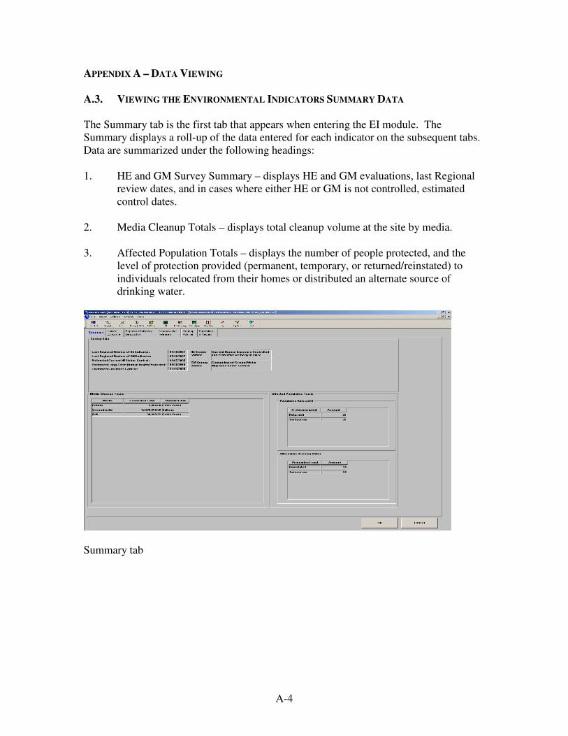
A-4
APPENDIX A – DATA VIEWING
A.3. VIEWING THE ENVIRONMENTAL INDICATORS SUMMARY DATA
The Summary tab is the first tab that appears when entering the EI module. The
Summary displays a roll-up of the data entered for each indicator on the subsequent tabs.
Data are summarized under the following headings:
1. HE and GM Survey Summary – displays HE and GM evaluations, last Regional
review dates, and in cases where either HE or GM is not controlled, estimated
control dates.
2. Media Cleanup Totals – displays total cleanup volume at the site by media.
3. Affected Population Totals – displays the number of people protected, and the
level of protection provided (permanent, temporary, or returned/reinstated) to
individuals relocated from their homes or distributed an alternate source of
drinking water.
Summary tab
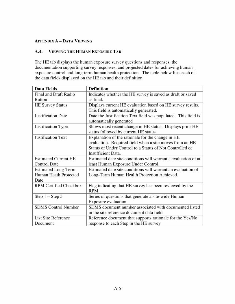
A-5
APPENDIX A – DATA VIEWING
A.4. VIEWING THE HUMAN EXPOSURE TAB
The HE tab displays the human exposure survey questions and responses, the
documentation supporting survey responses, and projected dates for achieving human
exposure control and long-term human health protection. The table below lists each of
the data fields displayed on the HE tab and their definition.
Data Fields Definition
Final and Draft Radio
Button
Indicates whether the HE survey is saved as draft or saved
as final.
HE Survey Status Displays current HE evaluation based on HE survey results.
This field is automatically generated.
Justification Date Date the Justification Text field was populated. This field is
automatically generated
Justification Type Shows most recent change in HE status. Displays prior HE
status followed by current HE status.
Justification Text Explanation of the rationale for the change in HE
evaluation. Required field when a site moves from an HE
Status of Under Control to a Status of Not Controlled or
Insufficient Data.
Estimated Current HE
Control Date
Estimated date site conditions will warrant a evaluation of at
least Human Exposure Under Control.
Estimated Long-Term
Human Heath Protected
Date
Estimated date site conditions will warrant an evaluation of
Long-Term Human Health Protection Achieved.
RPM Certified Checkbox Flag indicating that HE survey has been reviewed by the
RPM.
Step 1 – Step 5 Series of questions that generate a site-wide Human
Exposure evaluation.
SDMS Control Number SDMS document number associated with documented listed
in the site reference document data field.
List Site Reference
Document
Reference document that supports rationale for the Yes/No
response to each Step in the HE survey

A-6
APPENDIX A – DATA VIEWING
Note: Full screen shot is not provided below, as a portion of the screen is currently under
undergoing modification.
Human Exposure tab

A-7
APPENDIX A – DATA VIEWING
A.5. VIEWING THE EXPOSURE PATHWAY DESCRIPTION TAB
The Exposure Pathway Description tab displays a textual summary of the rationale
explaining why a site has not achieved a human exposure status of "Under Control" or
greater. This rational is only required for sites with a human exposure status of "Not
Controlled" or "Insufficient Data."
The summary will be marked as "unofficial" until it is approved by the Headquarters EI
Coordinator which is noted by a checkbox at the top of the screen.
Exposure Pathway Description tab

A-8
APPENDIX A – DATA VIEWING
A.6. VIEWING THE MIGRATION OF CONTAMINATED GROUNDWATER UNDER
CONTROL TAB
The GM tab displays the migration of contaminated groundwater survey questions and
responses, the documentation supporting survey responses, and projected dates for
achieving groundwater migration control. The table below lists each of the data fields
displayed on the GM tab and their definition.
Data Fields Definition
Final and Draft Radio
Button
Indicates whether the GM survey is saved as draft or saved
as final.
GM Survey Status Displays current GM evaluation based on GM survey
results. This field is automatically generated.
Justification Date Date the Justification Text field was populated. This field is
automatically generated
Justification Type Shows most recent change in GM status. Displays prior
GM status followed by current status.
Justification Text Explanation of the rationale for the change in GM
evaluation. Required field when a site moves from a GM
Status of "Under Control" to a Status of "Not Controlled" or
"Insufficient Data."
Estimated GM Control
Date
Estimated date site conditions will warrant a status of
"Groundwater Migration Under Control." Required field
for sites with a GM status of "Not Controlled" or
"Insufficient Data."
RPM Certified Checkbox Flag indicating that GM survey has been reviewed by the
RPM.
Step 1 – Step 5 Series of questions that generate a site-wide Migration of
Contaminated Under Control evaluation.
SDMS Control Number SDMS document number associated with documented listed
in the site reference document data field.
List Site Reference
Document
Reference document that supports rationale for the Yes/No
response to each Step in the HE survey

A-9
APPENDIX A – DATA VIEWING
Groundwater Releases tab
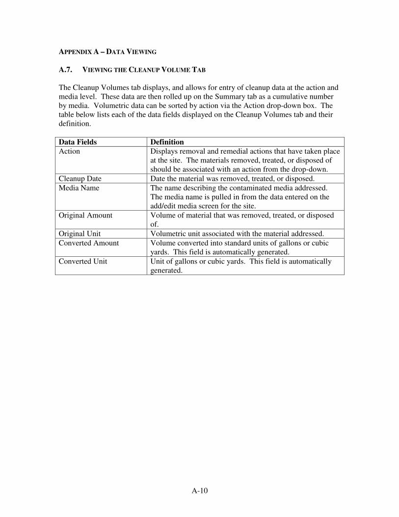
A-10
APPENDIX A – DATA VIEWING
A.7. VIEWING THE CLEANUP VOLUME TAB
The Cleanup Volumes tab displays, and allows for entry of cleanup data at the action and
media level. These data are then rolled up on the Summary tab as a cumulative number
by media. Volumetric data can be sorted by action via the Action drop-down box. The
table below lists each of the data fields displayed on the Cleanup Volumes tab and their
definition.
Data Fields Definition
Action Displays removal and remedial actions that have taken place
at the site. The materials removed, treated, or disposed of
should be associated with an action from the drop-down.
Cleanup Date Date the material was removed, treated, or disposed.
Media Name The name describing the contaminated media addressed.
The media name is pulled in from the data entered on the
add/edit media screen for the site.
Original Amount Volume of material that was removed, treated, or disposed
of.
Original Unit Volumetric unit associated with the material addressed.
Converted Amount Volume converted into standard units of gallons or cubic
yards. This field is automatically generated.
Converted Unit Unit of gallons or cubic yards. This field is automatically
generated.

A-11
APPENDIX A – DATA VIEWING
Cleanup Volumes tab
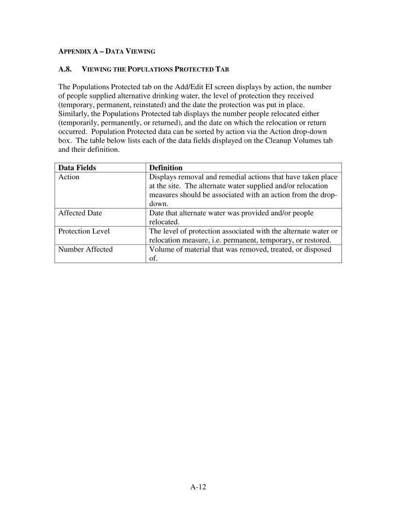
A-12
APPENDIX A – DATA VIEWING
A.8. VIEWING THE POPULATIONS PROTECTED TAB
The Populations Protected tab on the Add/Edit EI screen displays by action, the number
of people supplied alternative drinking water, the level of protection they received
(temporary, permanent, reinstated) and the date the protection was put in place.
Similarly, the Populations Protected tab displays the number people relocated either
(temporarily, permanently, or returned), and the date on which the relocation or return
occurred. Population Protected data can be sorted by action via the Action drop-down
box. The table below lists each of the data fields displayed on the Cleanup Volumes tab
and their definition.
Data Fields Definition
Action Displays removal and remedial actions that have taken place
at the site. The alternate water supplied and/or relocation
measures should be associated with an action from the drop-
down.
Affected Date Date that alternate water was provided and/or people
relocated.
Protection Level The level of protection associated with the alternate water or
relocation measure, i.e. permanent, temporary, or restored.
Number Affected Volume of material that was removed, treated, or disposed
of.

A-13
APPENDIX A – DATA VIEWING
Populations Affected tab

B-1
Appendix B – DATA ENTRY
The purpose of the data entry section is to provide instructions for entering data in
support of the EI Program. The methods used to report EI data at important milestones
of cleanup are detailed below. The frequency of data entry should, at a minimum, be
once a year. However, by entering data at more frequent intervals, the EI module will
serve as a better tool for the Regions to monitor their progress. Detailed guidance on the
frequency for EI data and the events that trigger the need to enter new date or update
existing data is provided in Sections 3 through 5 of this document.
B.1. ENTERING SITE-WIDE HUMAN EXPOSURE DATA
1. In CERCLIS use the following path to access the Human Exposures tab within
the EI Module:
Views menu>Program Management>Environmental Indicators>Human
Exposures tab. Or, alternatively, Views>Site Information>Site Status and
Description/Operable Units>Environmental Indicators Survey
button>Human Exposures tab.
2. Enter a response to Step 1 of the Human Exposure survey. Based on your
response you will continue to the next step or the survey will be complete. A
pop-up box will provide notification when enough information has been entered
to generate a HE status and that the survey is complete. Note: Depending on
your response to a survey question, the subsequent question may not be
applicable. If this is the case the response field will be greyed out, and you will
need to move on to the next question (the next applicable question will have a
drop-down box that is editable). Continue on with the survey until a pop-up box
is generated notifying you that the survey is complete.
3. Provide documentation of your response in the Reference Document fields.
Documents such as RODs, Action Memoranda, POLREPS, and Close Out
Reports often provide necessary background information. If you know the SDMS
document number associated with the reference document, please enter it in the
SDMS Document ID field.

B-2
APPENDIX B – DATA ENTRY
4. Once all survey responses have been entered, a text box will be generated
notifying the user that the survey has been completed. The results of the
responses will be displayed in the HE Survey Status box on the top of the tab.
5. Once all data have been entered, and the survey has been certified by the
appropriate person(s), click on the RPM Certified checkbox.
6. Select either the "Final" or "Draft" radio button. Please note: The "Draft"
option is not meant to be a substitute for cases when insufficient data are available
at a site. It is included in the survey with the intention of functioning as a short-
term placeholder for cases where the user has not completed the survey and
wishes to save without losing information. Once a survey is saved as "Draft," the
survey will display the evaluation of "Online Worksheet Saved as Draft". Once
the user is able to complete the survey, the "Final" radio button should be
selected.
7. Exit out of the HE survey. If the survey status at the top of the screen does not
result in either "Human Exposure Under Control" or "Long-Term Human Health
Protection Achieved," upon exiting the module, you will be required to enter
estimated dates for which Human Exposure and Long-Term Human Health
Protection are expected to be achieved.
Additionally, if the survey status at the top of the screen is either "Insufficient
Data" or "Human Exposure Not Controlled," you will be prompted to enter a
summary explaining the rationale as to why the site is not yet considered "Human
Exposure Under Control." Enter this summary in the Exposure Pathway
Description text box at the top of the screen. Please see Section 4.4 for guidance
on the information that should be included in the justification summary.
Finally, you will be prompted as to whether you wish to update the Regional HE
Review Date. If you are entering data for the first time, are making an update to
the survey, or if you reviewed each survey response but no changes were
required, select "Yes." If you are entering data in another module and haven't
reviewed the HE survey, select "No." You will then be prompted as to whether
you wish to update the Regional GM Review Date. If you have reviewed or made

B-3
APPENDIX B – DATA ENTRY
changes to the data on the GM tab select "Yes," if not, select "No." You will then
be prompted as to whether or not you wish to save your data. Select "Yes."
B.2. ENTERING MIGRATION OF CONTAMINATED GROUND WATER UNDER CONTROL
1. In CERCLIS use the following path to access the Groundwater Releases tab
within the EI Module:
Views menu>Program Management>Environmental
Indicators>Groundwater Releases tab. Or, alternatively, Views>Site
Information>Site Status and Description/Operable Units>Environmental
Indicators Survey button>Groundwater Releases tab.
2. Enter a response to Step 1 of the GM survey. Based on your response you will
continue to the next step or the survey will be complete. A pop-up box will
provide notification when enough information has been entered to generate a HE
status and that the survey is complete. Note: Depending on your response to a
survey question, the subsequent question may not be applicable. If this is the case
the response field will be greyed out, and you will need to move on to the next
question (the next applicable question will have a drop-down box that is not
greyed out). Continue on with the survey until a pop-up box is generated
notifying you that the survey is complete.
3. Provide documentation of your response in the Reference Document fields.
Documents such as RODs, Action Memoranda, POLREPS, and Close Out
Reports often provide necessary background information. If you know the SDMS
document number associated with the reference document, please enter it in the
SDMS Document ID field.
4. Once the survey is completed, the survey evaluation will be displayed in the
Survey Status box on the Ground Water Releases and Summary tab.
5. Once all data have been entered, and the survey has been certified by the
appropriate person(s), click on the RPM Certified checkbox.
B-4
APPENDIX B – DATA ENTRY
6. Select either the "Final" or "Draft" radio button. Please note: The "Draft" save
option is not meant to be a substitute for cases where insufficient data are
available at a site. It is included in the survey with the intention of functioning as
a short-term placeholder for instances where the user has not completed the
survey and wishes to save without losing data. Once a survey is saved as "Draft,"
the survey
7. Exit out of the GM survey. If the survey status at the top of the screen does not
result in "Groundwater Migration Under Control," upon exiting the module, you
will be required to enter an estimated date for which control of the migration of
contaminated groundwater is expected to be achieved.
Additionally, if the survey status at the top of the screen is either "Insufficient
Data" or "Groundwater Migration Not Controlled," you will be prompted to enter
a summary explaining the rationale as to why the site is not yet considered
"Contaminated Groundwater Migration Under Control." Enter this summary in
the Justification text box at the top of the screen.
Finally, you will be prompted as to whether you wish to update the Regional HE
Review Date. If you have reviewed or made changes to the data on the HE tab
select "Yes," if not, select "No." You will then be prompted as to whether you
wish to update the Regional GM Review Date. If you are entering data for the
first time, are making an update to the survey, or if you reviewed each survey
response but no changes were required, select "Yes." If you are entering data in
another module and haven't reviewed the GM survey, select "No." You will then
be prompted as to whether or not you wish to save your data. Select "Yes."
B-5
APPENDIX B – DATA ENTRY
B.3. ENTERING CLEANUP VOLUME EI DATA
1. In CERCLIS use the following path to access the Cleanup Volumes tab within the
EI Module:
Views menu>Program Management>Environmental Indicators>Cleanup
Volumes tab. Or, alternatively, Views>Site Information>Site Status and
Description/Operable Units>Environmental Indicators Survey
button>Cleanup Volumes tab.
2. To enter a cleanup volume, select the action from the Action drop-down menu
for which the cleanup volume you wish to enter has been applied. (Note:
Selecting "All" from the Action Drop-down will display all actions and
corresponding media at a site).
3. Once you have selected the appropriate action or have chosen to view all actions,
enter the date the volume was cleaned up in the Cleanup Date field.
4. Select the Media Name drop-down menu and select the appropriate Media
Name and Media Type for the particular action for which you wish to enter a
volume. (Note: if the media name for which the cleanup volume was applied is
not available for the particular action you selected, it must be entered on the
Add/Edit Media screen via the SCAP or Remedy screens. Once entered, it will
then be available on the Media Name drop-down menu).
5. Enter the Original Cleanup Amount and Original Unit. Units can be entered as
"non-standard" units as they are automatically converted to standard units of
gallons or cubic yards in the Converted Amount and Converted Unit fields.
(Note: Non-standard units available from the "Original Unit" drop-down include:
(Cubic Feet; Drums; Liters; Tons; Pounds; Cubic Meters; Tanks; Cylinders; and
Battery Casings).
6. To save a new entry, select the "Summary" tab and click on the "OK" button.
Cumulative volumetric totals can then be viewed on the "Summary" tab. Exit out
of the EI module and you will be prompted to save changes.
B-6
APPENDIX B – DATA ENTRY
B.4. ENTERING POPULATIONS PROTECTED EI DATA
1. In CERCLIS use the following path to access the Populations Protected tab within
the EI Module:
Views menu>Program Management>Environmental Indicators>Populations
Affected tab. Or, alternatively, Views>Site Information>Site Status and
Description/Operable Units>Environmental Indicators Survey
button>Populations Affected tab.
2. Data entry fields for Population Relocated and Alternative Drinking Water
Supplied are both displayed on the Populations Affected tab. First, select the
action from the Action drop-down menu for which the Population Relocated or
Alternate Drinking Water Supplied response was applied. (Note: Unlike on the
Cleanup Volume tab, data entry is not permitted when "All" is displayed on the
Action drop-down box. This is due to the fact that on the Cleanup Volume tab
you are still required to select an action associated to a medium on the Media
Name drop-down-box. Because Population Protected data are not associated with
a Medium, you are required to select a specific action (rather than "All") to which
either population relocated or alternate drinking water supplied data is
associated).
3. Select the Add Row button. (Note: You may receive a data warning message
stating "No Populations Relocated Response Actions Currently Exist for this Site
or No Alternative Drinking Water Response Actions Currently Exist for this
Site". If this message appears, you will still be permitted to enter data, however
for data quality purposes, the applicable population relocated and/or alternate
water supplied response action should be entered on the Add/Edit Response
Actions screen via the SCAP or Remedy Screens.).
4. Enter the Affected Date the population was either relocated or provided
alternative drinking water.
5. Enter the Protection Level (either Permanent, Temporary or
Returned/Reinstated) applied toward the population.
B-7
APPENDIX B – DATA ENTRY
6. Enter the number of individuals relocated or receiving alternative drinking water
in the Number Affected field. Once all data have been entered, and the survey
has been certified by the appropriate person(s), click on the RPM Certified
checkbox
7. To save a new entry, select the Summary tab and click on the OK button.
Cumulative Population Relocation and Alternative Drinking Water Supplied data
can be viewed on the "Summary" tab. Exit out of the EI module and you will be
prompted to save changes.

B-8
APPENDIX B – DATA ENTRY
B.5. ENVIRONMENTAL INDICATOR REPORTS
As described in Section 2.5 of the Guidance, a number of EI Reports are available at both
the Regional and National levels.
These include:
PGMT-08 Environmental Indicators Audit Report
Displays sites were there is incomplete Cleanup Volume data. This report can be used to
identify discrepancies in Cleanup Volume data at the National, Regional, State, or site-
specific levels.
PGMT-09 Data Compilation Report
Summary of site Population Protected and Cleanup Volume data. This report can be used
to ensure that all data for a site are entered completely and accurately.
PGMT-10 Site Turnaround Report
Summary of site Population Protected and Cleanup Volume data. This report was
designed to be used in conjunction with the PGMT-09 as a data entry guide.
PGMT-11 Environmental Indicators HE/GM Report
Site summary detail and Regional summary count of HE and GM evaluations and last
Regional and Headquarters review dates.
PGMT-12 Environmental Indicators HE/GM Error Report
Displays a site summary of data gaps and potential reporting errors for the Human
Exposure and Migration of Contaminated Ground Water Under Control EI's.
PGMT-13 Environmental Indicators Summary Report
Quick reference cumulative summary of all EI data–Populations Protected, Cleanup
Volumes, Human Exposure Under Control, and Migration of Contaminated Ground
Water Under Control.

B-9
APPENDIX B – DATA ENTRY
SCAP-15 GPRA Report
Tracks GPRA goals and performance measures in support of the Superfund and Federal
Facilities Response Program. Displays current HE and GM category counts,
accomplishments, and changes in HE or GM status at the Regional and National level.
B.6. ACCESSING ENVIRONMENTAL INDICATOR REPORTS
1. Select the Reports icon located on the CERCLIS toolbar.
2. After the "Reports Library" screen is displayed, select "Program Management" in
the Program Area filter. This will display the list of reports associated with
"Program Management".
3. By highlighting and selecting any of the PGMT reports described above, the
"Options" menu will appear.
4. Select applicable Region, fiscal year, selection criteria, and report type
(summary or detail).
5. Once the criteria is selected, click "Run".

B-10
APPENDIX B – DATA ENTRY
Program Management Reports