supporting report (2) - jicaopen_jicareport.jica.go.jp/pdf/11603305_12.pdf · supporting report (2)...
TRANSCRIPT

The Study on Comprehensive Disaster Preventionaround Mayon Volcano
SUPPORTING REPORT (2)
(Part II: Feasibility Study)
XXII : Resettlement Site Development
i
SUPPORTING REPORT (2) - XXIIRESETTLEMENT SITE DEVELOPMENT
Table of Contents
Page
1. RESETTLEMENT PROJECT .........................................................................XXII - 11.1 Existing Resettlement Site Development...................................................XXII - 11.2 Present Condition and Problems ................................................................XXII - 2
2. BASIC CONCEPT .........................................................................................XXII - 102.1 Purpose of the Project ..............................................................................XXII - 102.2 Basic Conditions for Resettlement Planning ...........................................XXII - 142.3 Expected Number of Resettlers and Households by Job Category..........XXII - 162.4 Supporting System for Livelihood and Area Socio-economic
Development ............................................................................................XXII - 17
3. LAYOUT DESIGN ........................................................................................XXII - 193.1 Banquerohan Resettlement Site (Phase I & II) ........................................XXII - 19
3.1.1 Land Use Layout Plan (Area Development Plan)......................XXII - 193.1.2 Infrastructures ............................................................................XXII - 243.1.3 Housing Lot Plan........................................................................XXII - 29
3.2 Anislag Resettlement Site ........................................................................XXII - 313.2.1 Land Use Layout (Area Development Plan)..............................XXII - 313.2.2 Infrastructures ............................................................................XXII - 333.2.3 Housing Lot Plan........................................................................XXII - 36
4. PRELIMINARY STRUCTURAL DESIGN ..................................................XXII - 364.1 Banquerohan Resettlement Site (Phase I & II) ........................................XXII - 364.2 Anislag Resettlement Site ........................................................................XXII - 39

ii
List of Tables
Page
Table XXII 1.1 Profile of the Banquerohan Resettlement Site and AnislagResettlement Plan ..................................................................XXII - 42
List of Figures
Page
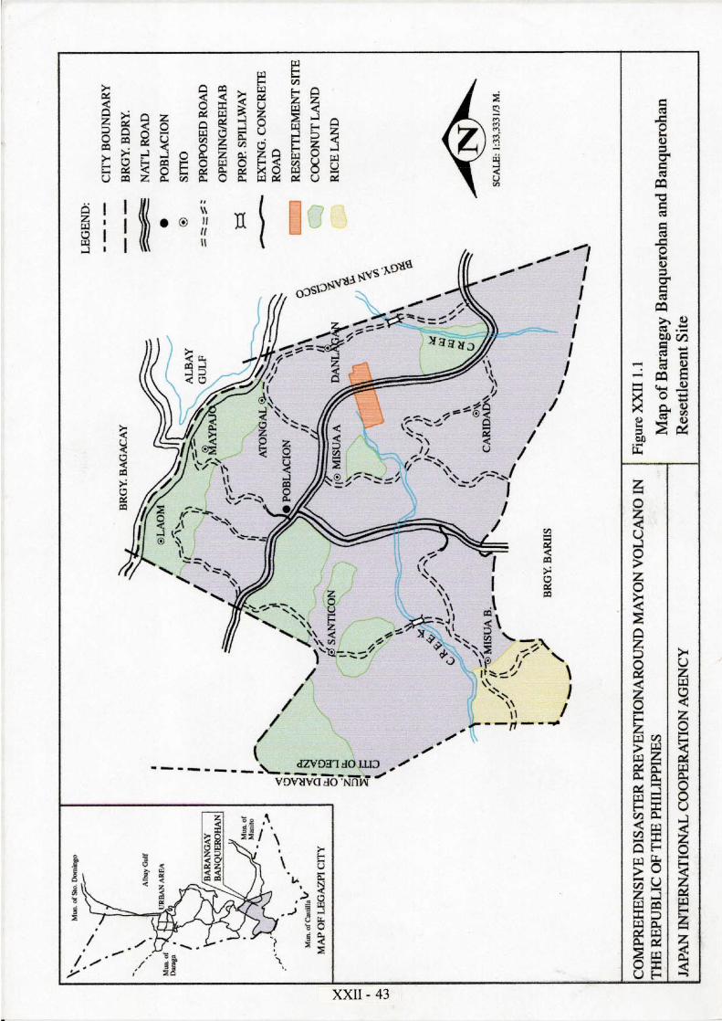
Figure XXII 1.1 Map of Barangay Banquerohan and Banqerohan ResettlementSite .........................................................................................XXII - 43
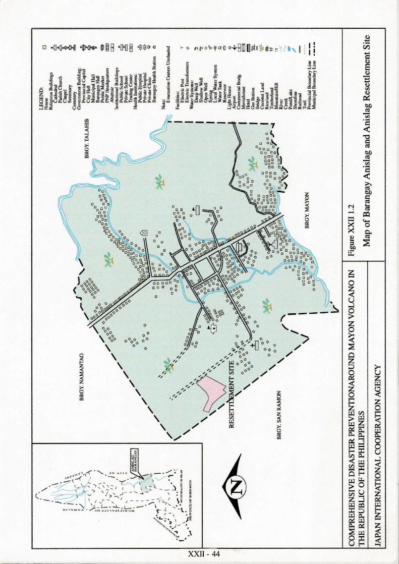
Figure XXII 1.2 Map of Barangay Anislag and Anislag Resettlement Site .....XXII - 44Figure XXII 2.1 Supporting System for Livelihood and Area Socio-Economic
Development...........................................................................XXII - 45Figure XXII 3.1 Subdivision Plan for Banquerohan Resettlement Phase I ......XXII - 46Figure XXII 3.2 Subdivision Plan for Banquerohan Resettlement Phase II ....XXII - 47Figure XXII 3.3 Standard Housing Layout Plan/Elevation ..............................XXII - 48Figure XXII 3.4 Water Supply Layout for Banquerohan Phase I .....................XXII - 49Figure XXII 3.5 Water Supply Layout for Banquerohan Phase II ...................XXII - 50Figure XXII 3.6 Power Supply Layout for Banquerohan Phase II ...................XXII - 51Figure XXII 3.7 Community and Livelihood Facilities Layout for
BanquerohaPhase I ................................................................XXII - 52Figure XXII 3.8 Community and Livelihood Facilities Layout for
BanquerohaPhase II ...............................................................XXII - 53Figure XXII 3.9 School Building Layout Plan .................................................XXII - 54Figure XXII 3.10 Chapel Layout Plan ................................................................XXII - 55Figure XXII 3.11 Multi-purpose hall Layout Plan .............................................XXII - 56Figure XXII 3.12 Health and Day Care Center Layout Plan ..............................XXII - 57Figure XXII 3.13 Productivity Center Layout Plan.............................................XXII - 58Figure XXII 3.14 Warehouse Layout Plan .........................................................XXII - 59Figure XXII 3.15 Subdivision Plan for Anislag Resettlement Site ....................XXII - 60Figure XXII 3.16 Water Supply Layout for Anislag Resettlement Site .............XXII - 61Figure XXII 3.17 Community and Livelihood Facilities Layout for Anislag
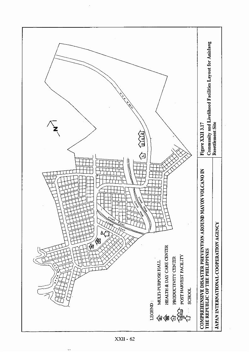
Resettlement Site ....................................................................XXII - 62
XXII - 1
SUPPORTING REPORT (2) - XXIIRESETTLEMENT SITE DEVELOPMENT
1. RESETTLEMENT PROJECT
1.1 Existing Resettlement Site Development
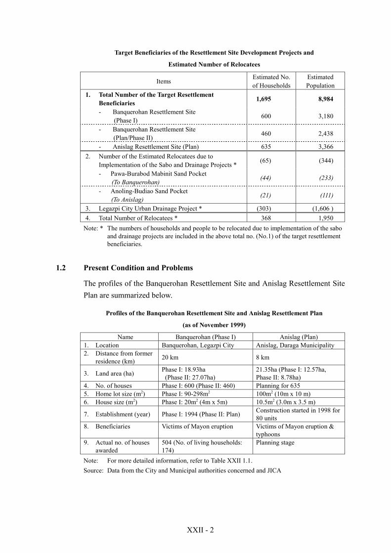
There are two types of relocation/resettlement issues to be considered in thisStudy. One is related to the resettlement of the people living within the 6km radiusfrom the crater of Mayon Volcano (or PDZ: Permanent Danger Zone) and mud &debris flow danger zones as well. The other concerns the “relocation” to be causedby implementation of the disaster prevention projects including acquisition of theright-of the way and sand pocket areas.
In connection with the two priority structural projects selected in the Master Plan :Yawa River System Sabo Project and Legazpi City Urban Drainage Project, theissues of relocation and resettlement site development in the Feasibility Studypertain to Legazpi City (Banquerohan) and Daraga Municipality (Anislag). Inprinciple, resettlement of the people is to be done within the respectiveadministrative divisions (city and municipalities concerned) as confirmed in thekey concepts for resettlement planning of Master Plan. As to their respectivelocations in the Study Area, refer to Figures XXII 1.1 and XXII 1.2.
Regarding the number of dwellers within the Permanent Danger Zone (PDZ), itwas estimated at 55 households (291 persons) in Legazpi City, as of March 1999.This figure is varying, especially after Mayon explosions in June and September1999. The latest data (as of October 1999) show that the PDZs in both LegazpiCity and Daraga Municipality are already “no-man land”. However, this does notexclude day-time farming of the people in PDZ, even though they do not stayovernight there.
Most of the evacuees or candidate resettlers are now lodging temporarily in theelementary schools or relative’s houses in Legazpi City and Budiao barangay(Daraga Municipality), respectively. The following table indicates the number oftarget beneficiaries of the resettlement site development projects to beaccommodated in Banquerohan (Legazpi City) and Anislag (Daraga Municipality).Following the social development plans of each LGU concerned, the resettlementsite development projects are designed to accommodate not only the Mayonvictims but also “social poor”.
XXII - 2
Target Beneficiaries of the Resettlement Site Development Projects and
Estimated Number of Relocatees
Items Estimated No.of Households
EstimatedPopulation
1. Total Number of the Target ResettlementBeneficiaries 1,695 8,984
- Banquerohan Resettlement Site(Phase I) 600 3,180
- Banquerohan Resettlement Site (Plan/Phase II) 460 2,438
- Anislag Resettlement Site (Plan) 635 3,3662. Number of the Estimated Relocatees due to
Implementation of the Sabo and Drainage Projects * (65) (344)
- Pawa-Burabod Mabinit Sand Pocket(To Banquerohan) (44) (233)
- Anoling-Budiao Sand Pocket(To Anislag) (21) (111)
3. Legazpi City Urban Drainage Project * (303) (1,606 )4. Total Number of Relocatees * 368 1,950
Note: * The numbers of households and people to be relocated due to implementation of the saboand drainage projects are included in the above total no. (No.1) of the target resettlementbeneficiaries.
1.2 Present Condition and Problems
The profiles of the Banquerohan Resettlement Site and Anislag Resettlement SitePlan are summarized below.
Profiles of the Banquerohan Resettlement Site and Anislag Resettlement Plan
(as of November 1999)
Name Banquerohan (Phase I) Anislag (Plan)1. Location Banquerohan, Legazpi City Anislag, Daraga Municipality2. Distance from former
residence (km) 20 km 8 km
3. Land area (ha) Phase I: 18.93ha (Phase II: 27.07ha)
21.35ha (Phase I: 12.57ha,Phase II: 8.78ha)
4. No. of houses Phase I: 600 (Phase II: 460) Planning for 6355. Home lot size (m2) Phase I: 90-298m2 100m2 (10m x 10 m)6. House size (m2) Phase I: 20m2 (4m x 5m) 10.5m2 (3.0m x 3.5 m)
7. Establishment (year) Phase I: 1994 (Phase II: Plan) Construction started in 1998 for80 units
8. Beneficiaries Victims of Mayon eruption Victims of Mayon eruption &typhoons
9. Actual no. of housesawarded
504 (No. of living households:174)
Planning stage
Note: For more detailed information, refer to Table XXII 1.1.Source: Data from the City and Municipal authorities concerned and JICA
XXII - 3
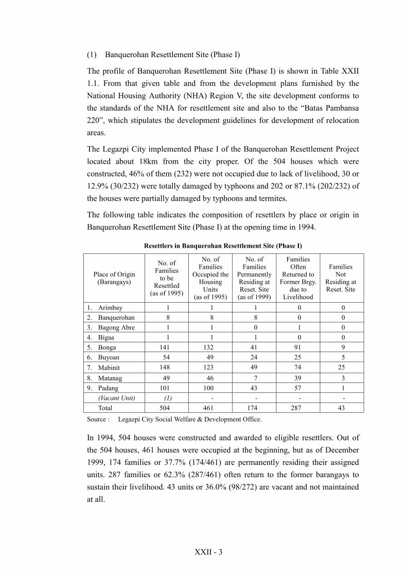
(1) Banquerohan Resettlement Site (Phase I)
The profile of Banquerohan Resettlement Site (Phase I) is shown in Table XXII1.1. From that given table and from the development plans furnished by theNational Housing Authority (NHA) Region V, the site development conforms tothe standards of the NHA for resettlement site and also to the “Batas Pambansa220”, which stipulates the development guidelines for development of relocationareas.
The Legazpi City implemented Phase I of the Banquerohan Resettlement Projectlocated about 18km from the city proper. Of the 504 houses which wereconstructed, 46% of them (232) were not occupied due to lack of livelihood, 30 or12.9% (30/232) were totally damaged by typhoons and 202 or 87.1% (202/232) ofthe houses were partially damaged by typhoons and termites.
The following table indicates the composition of resettlers by place or origin inBanquerohan Resettlement Site (Phase I) at the opening time in 1994.
Resettlers in Banquerohan Resettlement Site (Phase I)
Place of Origin(Barangays)
No. ofFamilies
to beResettled
(as of 1995)
No. ofFamilies
Occupied theHousing
Units(as of 1995)
No. ofFamilies
PermanentlyResiding atReset. Site
(as of 1999)
FamiliesOften
Returned toFormer Brgy.
due toLivelihood
FamiliesNot
Residing atReset. Site
1. Arimbay 1 1 1 0 02. Banquerohan 8 8 8 0 03. Bagong Abre 1 1 0 1 04. Bigaa 1 1 1 0 05. Bonga 141 132 41 91 96. Buyoan 54 49 24 25 57. Mabinit 148 123 49 74 258. Matanag 49 46 7 39 39. Padang 101 100 43 57 1
(Vacant Unit) (1) - - - -Total 504 461 174 287 43
Source : Legazpi City Social Welfare & Development Office.
In 1994, 504 houses were constructed and awarded to eligible resettlers. Out ofthe 504 houses, 461 houses were occupied at the beginning, but as of December1999, 174 families or 37.7% (174/461) are permanently residing their assignedunits. 287 families or 62.3% (287/461) often return to the former barangays tosustain their livelihood. 43 units or 36.0% (98/272) are vacant and not maintainedat all.

XXII - 4
The social welfare and development office (SWDO) of Legazpi City has yet toprepare a comprehensive list of beneficiaries that are still to be relocated toBanquerohan, their place of origin, those who returned to their former barangays,and those that permanently reside in the site.
The physical conditions of about 25% of the housing units already constructed arebad and latest assessment is that these units are not conducive for habitation. Thisis due to the absence of staff from local government who will safeguard thehousing units. Basic housing components such as doors and windows were lootedon some of these completed units. Aside from looting, some people have madethese housing units as animal barns and stockyards. This hastened thedeterioration of basic housing parts.
Circulation (roads, alleys and paths) on the eastern side of the resettlement site hasalready deteriorated largely due to soil erosion. Vegetation has covered much ofthe right-of-way on this portion.
As a whole, the present conditions of the housing units in Phase I including theroad network can not accommodate new resettlers, unless rehabilitation of basicfacilities and full completion of dilapidated housing units are to be undertaken bythe local government.
(2) Existing Resettlement Plans (including Expansion Plans of the Existing Site)
1) Banquerohan Resettlement Site (Phase II)
The project profile of Phase II is also shown in Table XXII 1.1. The concept forthe development of Phase II site is to serve as production area for the wholeBanquerohan Resettlement Site. A large portion of Phase II (8.8 ha or 32.6%) isidentified as area earmarked for agricultural purposes.
According to the Phase II development plan prepared by the NHA, the subdivisionsurvey was already implemented by a local contractor. However, housing units arestill absent including power and water supply. Considerable resources are stillneeded to fully complete Phase II and this is to be utilized as additionalresettlement site for Mayon eruption victims. About a fourth of Phase II is nowbeing used by resettlers from Phase I as their farm lots. Many of them plantvegetables and other cash crops.
2) Anislag Resettlement Plan
The land development for this resettlement site has already been completed basedon the standards stipulated under Batas Pambansa 220, a law governing the
XXII - 5
development standards for low-cost housing projects including resettlement sitesof the government.
The resettlement area can only be reached from the main provincial road throughthe 1.5km macadam access road. This access road is being used by both theresettlers and the residents living nearby.
The local government started constructing core housing units on some of thegenerated lots. The arrangement for the construction of the units is that thematerials needed will be provided by the local government while constructing the3m x 3.5m. Unit will be the counterpart share of the beneficiary. The material costper individual unit is presently estimated to cost about PHP25,000 per unit.
The community facilities such as barangay hall, health and day care center,primary school and livelihood training centers are still absent. However, all ofthese facilities except the livelihood training center are already existing outsidethe site (in Anislag barangay) and are located along the provincial road.
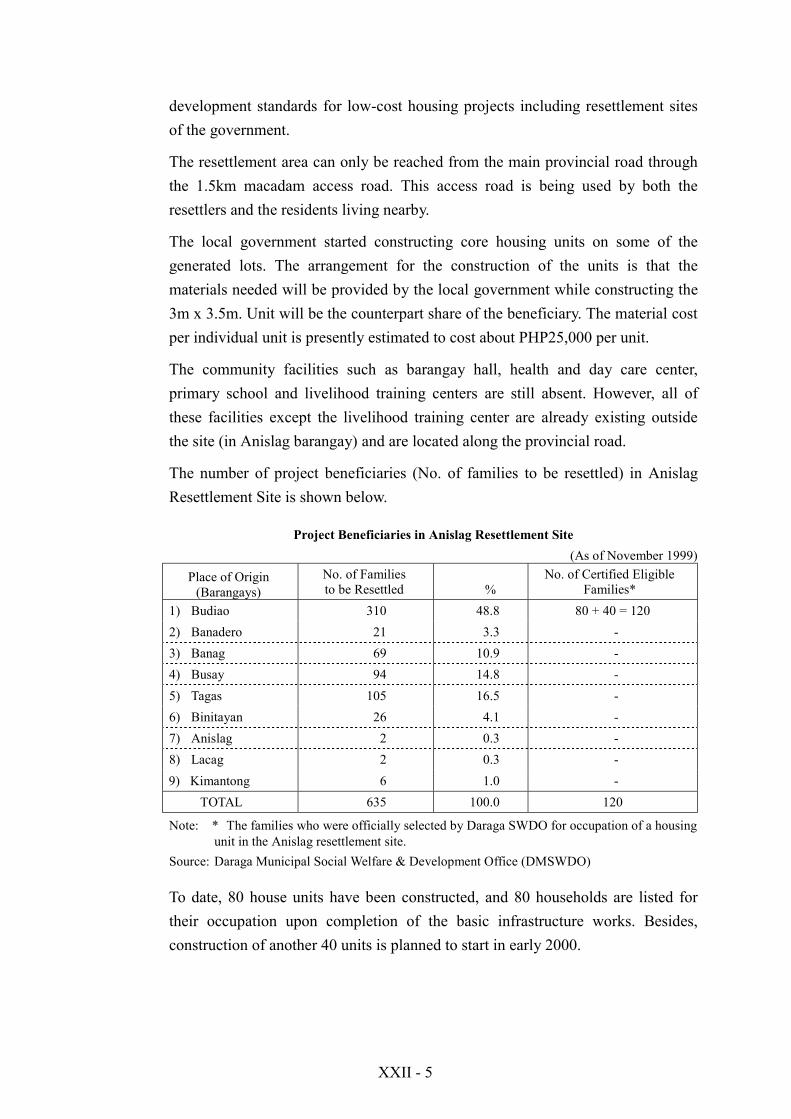
The number of project beneficiaries (No. of families to be resettled) in AnislagResettlement Site is shown below.
Project Beneficiaries in Anislag Resettlement Site(As of November 1999)
Place of Origin(Barangays)
No. of Familiesto be Resettled %
No. of Certified EligibleFamilies*
1) Budiao 310 48.8 80 + 40 = 1202) Banadero 21 3.3 -3) Banag 69 10.9 -4) Busay 94 14.8 -5) Tagas 105 16.5 -6) Binitayan 26 4.1 -7) Anislag 2 0.3 -8) Lacag 2 0.3 -9) Kimantong 6 1.0 -
TOTAL 635 100.0 120
Note: * The families who were officially selected by Daraga SWDO for occupation of a housingunit in the Anislag resettlement site.
Source: Daraga Municipal Social Welfare & Development Office (DMSWDO)
To date, 80 house units have been constructed, and 80 households are listed fortheir occupation upon completion of the basic infrastructure works. Besides,construction of another 40 units is planned to start in early 2000.

XXII - 6
(3) Problems Encountered
1) Socio-economic Problems
From the results gathered in the People’s Intention Survey conducted by the JICAStudy Team, the following are the listed reasons with the majority of therespondents are not satisfied with the living conditions in the resettlement area:
! The size of the lot is small,! The house was poorly built,! The location is very elevated (Banquerohan),! Water supply and drainage system are inadequate,! Inadequacy of electricity,! Lack of street lights,! Absence of farm lots for farmer resettlers,! No sources of livelihood,! Slippery roads,! Sanitation such as lack of comfort rooms (Banquerohan),! High transportation cost,! Distant location of schools,! Illegal squatting of non-beneficiaries,! Non occupancy of some units by beneficiaries, and! Rampant theft.
a. Banquerohan Phase I
Of the many problems being encountered by the beneficiaries inBanquerohan Phase I, lack of livelihood opportunities ranked first. Theincome profile based on the result of the “People’s Intention Survey forResettlers and Candidate Resettlers in Resettlement Site Improvement andLivelihood Development” revealed that the annual income per household isPHP42,075 or a monthly household income of PHP3,506. The income figurederived from this survey is below the PHP4,800 perceived adequate income.
Some resettlers acquired their own farm lots on nearby sites. Sometemporarily farm on Phase II lots as of date. Farm sites for resettlers are notyet identified yet. Other sources of livelihood are abaca weaving,buying/selling. Few go into fishing.
Lack of livelihood opportunities in the site have made life difficult for theresettled families and this problem compounded their dissatisfaction to theirnew homes as shown below.
XXII - 7
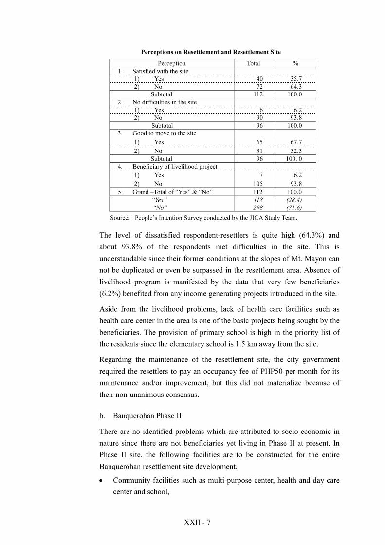
Perceptions on Resettlement and Resettlement Site
Perception Total %1. Satisfied with the site
1) Yes 40 35.72) No 72 64.3
Subtotal 112 100.02. No difficulties in the site
1) Yes 6 6.22) No 90 93.8
Subtotal 96 100.03. Good to move to the site
1) Yes 65 67.72) No 31 32.3
Subtotal 96 100. 04. Beneficiary of livelihood project
1) Yes 7 6.22) No 105 93.8
5. Grand –Total of “Yes” & “No” 112 100.0 “Yes” 118 (28.4)
“No” 298 (71.6)Source: People’s Intention Survey conducted by the JICA Study Team.
The level of dissatisfied respondent-resettlers is quite high (64.3%) andabout 93.8% of the respondents met difficulties in the site. This isunderstandable since their former conditions at the slopes of Mt. Mayon cannot be duplicated or even be surpassed in the resettlement area. Absence oflivelihood program is manifested by the data that very few beneficiaries(6.2%) benefited from any income generating projects introduced in the site.
Aside from the livelihood problems, lack of health care facilities such ashealth care center in the area is one of the basic projects being sought by thebeneficiaries. The provision of primary school is high in the priority list ofthe residents since the elementary school is 1.5 km away from the site.
Regarding the maintenance of the resettlement site, the city governmentrequired the resettlers to pay an occupancy fee of PHP50 per month for itsmaintenance and/or improvement, but this did not materialize because oftheir non-unanimous consensus.
b. Banquerohan Phase II
There are no identified problems which are attributed to socio-economic innature since there are not beneficiaries yet living in Phase II at present. InPhase II site, the following facilities are to be constructed for the entireBanquerohan resettlement site development.
! Community facilities such as multi-purpose center, health and day carecenter and school,

XXII - 8
! Livelihood facilities such as training centers and production areas, and! Post-harvest facilities for storage of goods.
c. Anislag Resettlement Site
This site is still in the process of absorbing new entrants from the PermanentDanger Zones (PDZs) and the residents would most likely list the followingneeds:
! Multi-purpose center! Health & day care center! Primary school! Livelihood facilities for cottage industries! Handicraft and training
2) Basic Facilities
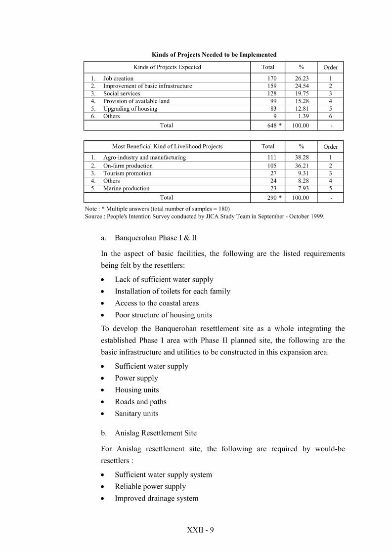
From the list of problems cited by the respondents in the People’s IntentionSurvey, majority of them is attributable to physical development of theresettlement site. As shown in the following table, the improvement of basicinfrastructure ranked second (24.5%) most needed project that should beimplemented in the site.
The upgrading of housing accounted for 12.8% of the total respondents andranked number five, should also be given emphasis especially the size of the floorarea and the quality of works and materials used. Of the five major projectsneeded, job creation or livelihood opportunities still ranked high (26.2%) in thelist.
XXII - 9
Kinds of Projects Needed to be Implemented
Order
1. Job creation 170 26.23 12. Improvement of basic infrastructure 159 24.54 23. Social services 128 19.75 34. Provision of available land 99 15.28 45. Upgrading of housing 83 12.81 56. Others 9 1.39 6
648 * 100.00 -
Order
1. Agro-industry and manufacturing 111 38.28 12. On-farm production 105 36.21 23. Tourism promotion 27 9.31 34. Others 24 8.28 45. Marine production 23 7.93 5
290 * 100.00 -
Note : * Multiple answers (total number of samples = 180)Source : People's Intention Survey conducted by JICA Study Team in September - October 1999.
Total
%Kinds of Projects Expected Total
Most Beneficial Kind of Livelihood Projects Total %
Total
a. Banquerohan Phase I & II
In the aspect of basic facilities, the following are the listed requirementsbeing felt by the resettlers:
! Lack of sufficient water supply! Installation of toilets for each family! Access to the coastal areas! Poor structure of housing units
To develop the Banquerohan resettlement site as a whole integrating theestablished Phase I area with Phase II planned site, the following are thebasic infrastructure and utilities to be constructed in this expansion area.
! Sufficient water supply! Power supply! Housing units! Roads and paths! Sanitary units
b. Anislag Resettlement Site
For Anislag resettlement site, the following are required by would-beresettlers :
! Sufficient water supply system! Reliable power supply! Improved drainage system

XXII - 10
2. BASIC CONCEPT
2.1 Purpose of the Project
The Resettlement Sites Development Project in Banquerohan (Legazpi City) andAnislag (Daraga Municipality) aims to improve the existing resettlement sites forthe people already settled and/or develop the new resettlement sites for the peoplestill residing in mud & debris and flood danger zones, and likewise for those to berelocated due to implementation of the Yawa River Basin Sabo Project andLegazpi City Urban Drainage Project.
As mentioned in the previous Subsection, the Banquerohan resettlement site(Phase I) was established in 1994 and 504 houses were awarded to the eligibleresettlers at the beginning. Despite it, presently only 174 families (35%) areoccupying them. The results of the People’s Intention Survey conducted by theJICA Study Team revealed that in addition to the lack of livelihood, this is partlydue to dilapidation of the houses and lack of basic infrastructure such as watersupply and sanitary facilities and so on. As to the resettlement site development atAnislag where the construction work has just started, the original plan also lacksin comprehensive approach to establish an integrated community.
Consequently, this Resettlement Sites Development Project proposed in this Studyis designed to cope with the problems the resettlers are actually facing, and satisfythe requirements of the resettlers to some extent to ensure their basic human needsor living environment.
(1) Economic Development in the Resettlement Sites
For a long time, the cause and effect relationship between disasters and social andeconomic development has been ignored. Taking into account the relationshipdescribed in Section 2.2 (5) (Main Report), the “concept of integrating disastersinto development” is becoming a major philosophical underpinning around theworld. For this respect, it is essential to formulate the development projects andprograms in the context of disaster prevention/mitigation, and design the disasterrecovery programs based on the long-term or far-reaching development needs.
As the major problems in the existing resettlement sites are pointed out due to thefact that the sites provide little job opportunity, a wide range of job creationopportunities will be provided to the resettlers considering their adaptability andbackground.
XXII - 11
Then, the resettlement site development projects need to be implemented as apackage with the livelihood and area development projects as well as institutional& financial supporting programs. The economic development in the resettlementsite mostly concerns the livelihood of the resettlers. The factors to be consideredin formulation of livelihood projects and programs are the following:
! Labour-intensive or employment generation program! Utilization of local resources (materials and expertise)! Prospects of marketability! Availability of the utilities (water and energy)
Based on the results of the Area Potential Survey carried out by the JICA StudyTeam in September – October 1999, the following are the key crops andpromising enterprises for livelihood and area economic development:
a. Coconut-based Crop Diversification
Intercrop banana, pineapple, black pepper, ginger, peanuts, and rootcropsbetween coconut trees
b. Abaca
Increase abaca primary production (need for new technology and highquality, virus resistant planting materials)
c. High Value Commercial Crops
Temperate, semi-temperate and some tropical fruit (ex. Pilinuts), vegetables,flowers, and ornamental plants (exploit Mt. Mayon’s higher elevations tocorner the Baguio market)
d. Cutflowers and Ornamental Plants
Take lead from neighboring municipalities, an ideal livelihood opportunityfor homebound individuals or those who have little access to land
e. Non-edible Agricultural Crops
Need expansion to generate livelihood opportunities because of limitedsupply of fiber, wood, culinary and medical herbs, ornamental plants,bamboo and roofing leaves

XXII - 12
f. Maize (Corn)
Expansion in northern and southern barangays, production for livestockfeeds, need for mechanization if large areas are planted
g. Rice (Rice growing)
Expansion in southern barangays need the pumps and shallow-tube wells
h. Poultry
Eggs, broilers, quail eggs and ducks
i. Coconut Coir and Coco dust
Establish a coconut processing facility in Banquerohan area (this capital-intensive project needs 2 ha site)
j. Gravel and Sand
Excavation of the gravel and sand required to assure the sound operations ofthe sabo facilities, and their value-added products like hollow blocks andconstruction materials for area development
k. Composting and Recycling Scheme
Processing of bio-degradable and non bio-degradable wastes (use oftrichoderma bacterium inoculant, pilot site in San Roque)
l. Eco-tourism
Sustainable approach to local resources and environment use (local peopleshare in service providing and profit sharing, while tourists learn somethingabout the local culture and its people)
(2) Criteria in Selecting Candidate Resettlers
As the criteria in selecting the candidate resettlers, there exist an useful reference :“Guidelines on the Implementation of SOLCENTAF Supported Core ShelterAssistance Program1”. In this Guidelines, the target beneficiaries for the disaster
1 Guidelines on the Implementation of SOLCENTAF Supported Core Shelter Assistance Program in
Rehabilitating Typhoons Rosing and Pepang Victims, Department Order No.19 of the DSWD, Seriesof 1996 (22 July 1996).
XXII - 13
victims like volcanic eruption, mud & debris flows, flood, typhoon, etc. wouldmeet the following conditions/criteria:
! With totally damaged houses as a result of the typhoon and on its secondaryhazards.
! Must be owner of the damaged house – not a renter or sharer.! Has not availed of GI sheets assistance from SOLCENTAF (Southern Luzon
Central Task Force).! Income must be within poverty threshold of the area (for a family of 5.3
members, PHP4,955 per month in urban areas and PHP4,020 per month inrural areas).
! Has been living in a high risk area such as along slope, flood prone areas, etc.! Has the capacity of providing his own counterpart in building his shelter like
labor, and any of the following: savings and salvage materials.
As the above guidelines was prepared and has been applied just to cope with theimminent situations in emergency cases, the JICA Study Team proposes thefollowing criteria and, especially with a view to upgrading the living environmentof resettlers and establishing a growth center for area economic development.
a. Those who are dwelling in the high risk areas such as:
! Permanent Danger Zones (PDZ),! Slopes of the Mayon Volcano where have been repeatedly struck by the
disasters of mud and debris flows, and! Flood prone areas.
b. The people living in the right-of-way areas where land acquisition isrequired for implementation of the structural projects like sabo facilityconstruction and urban drainage projects.
c. The household whose house was totally damaged as a result of the naturaldisasters including typhoon.
! The applicant must be owner of the damaged house – not a renter orsharer.
d. Family of low bracket income: its monthly average income must be belowthe estimated monthly household income of the area2 (for 5.3 members,PHP10,000 per month as of 1999).
2 The monthly household income in the Study Area is set based on the data used for estimating the
target per capita GRDP in formulation of the socio-economic development scenario.

XXII - 14
e. The beneficiary occupant who accepts to pay the occupancy andmaintenance charge of the site.
In these criteria, the monthly household income (PHP10,000) is set higher (almostdouble) compared to the monthly poverty threshold laid down by the authoritiesconcerned (NSO& NSCB). This is from the standpoint that the resettlement site isto be a future “development growth center” or basis for area economicdevelopment. Hence, this relatively higher criterion is set to induce the people’smotivations and give some incentives for their economic activities.
2.2 Basic Conditions for Resettlement Planning
(1) Living Condition in Structural Aspect
The living condition of the resettlers in structural aspect must at least meet theminimum requirements if not of the very ideal characteristics of a dwelling unit,and a physical environment. For the dwelling units, it must have at least thefollowing:
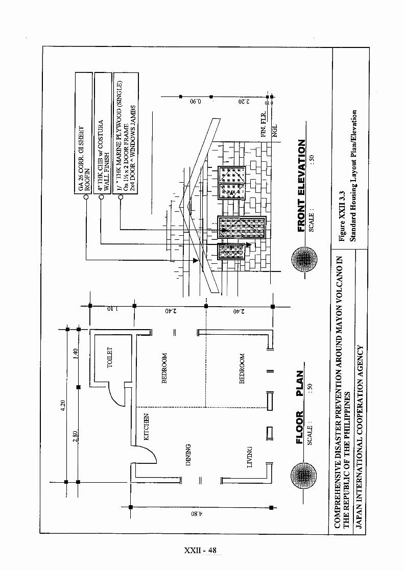
! Adequate space for domestic needs such as bedroom, a kitchen and the like(Total floor area of standard Type I: 21.7m2). As to floor plan, refer to FigureXXII 3.3.
! Individual bath and toilet! Sufficient supply for water for drinking and domestic use (150 liters/capita/
day)! Electric power connection per housing unit! Garbage disposal and sewage! Dwelling units must be durable enough to withstand the usual calamities like
typhoons or strong winds
Taking into consideration the general situations mentioned above, the basicconditions for resettlement sites development with livelihood programs are asfollows:
a. A core house of 21.7m2 (Type I) will be provided free of charge to the eligiblefamily by the LGU,
b. For expansion and betterment of the core house, financial assistance will begranted to the applicant resettlers (through a multi-purpose cooperative to beestablished in the site),
c. To those who are going to undertake the gradual expansion of the house ingroup of more than 5 families, the LGU will extend assistance to supervise itsconstruction works,
XXII - 15
d. Maintenance fund of the resettlement site including the public facilities andrespective houses should be raised and contributed by the resettlersthemselves.
e. To form an integrated community, the resettlement site will include almost allsocial infrastructures like road, water supply, power supply, drainage &sewerage, elementary school, parks & open space, and even a “productivitycenter” for livelihood development.
(2) Livelihood Support
In addition to improvement of the structural living condition, the livelihooddevelopment support needs to be provided by establishing a “productivity center”which incorporates an area for business, trading, processing and storage activitiesas well as skills training area. This center will accommodate areas for communitybusiness service, training and display.
The resettlement sites development project with livelihood development programis to be formulated and promoted in close coordination with the governmentagencies (both national and local) and organizations concerned includingsupporting institutions (international donor, private sector and NGOs).
The basic conditions for supporting the livelihood development of the resettlersinclude the following:
a. Institutional and legal arrangements among the implementing agencies andorganizations concerned,
b. Social preparation including briefing to the property owners and affectedhouseholds, and public hearings,
c. Establishment of community relations through community developmentworkers,
d. Setting-up of community organizations, especially multi-purpose cooperativeand cooperative business association (CBA),
e. Provision of micro-lending scheme to support the resettlers to open up thelivelihood enterprises, and
f. Training for livelihood development and vocational guidanceg. Organizational set-up of a “Resettlement Committee” to coordinate/ensure the
resettlement activities,
XXII - 16
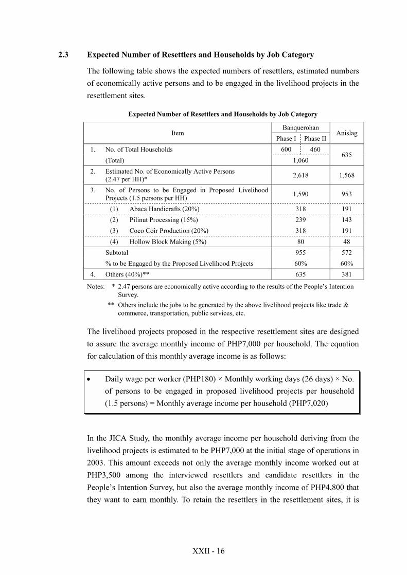
2.3 Expected Number of Resettlers and Households by Job Category
The following table shows the expected numbers of resettlers, estimated numbersof economically active persons and to be engaged in the livelihood projects in theresettlement sites.
Expected Number of Resettlers and Households by Job Category
BanquerohanItem
Phase I Phase IIAnislag
1. No. of Total Households 600 460(Total) 1,060
635
2. Estimated No. of Economically Active Persons(2.47 per HH)* 2,618 1,568
3. No. of Persons to be Engaged in Proposed LivelihoodProjects (1.5 persons per HH) 1,590 953
(1) Abaca Handicrafts (20%) 318 191(2) Pilinut Processing (15%) 239 143(3) Coco Coir Production (20%) 318 191(4) Hollow Block Making (5%) 80 48
Subtotal 955 572% to be Engaged by the Proposed Livelihood Projects 60% 60%
4. Others (40%)** 635 381
Notes: * 2.47 persons are economically active according to the results of the People’s IntentionSurvey.
** Others include the jobs to be generated by the above livelihood projects like trade &commerce, transportation, public services, etc.
The livelihood projects proposed in the respective resettlement sites are designedto assure the average monthly income of PHP7,000 per household. The equationfor calculation of this monthly average income is as follows:
! Daily wage per worker (PHP180) × Monthly working days (26 days) × No.of persons to be engaged in proposed livelihood projects per household(1.5 persons) = Monthly average income per household (PHP7,020)
In the JICA Study, the monthly average income per household deriving from thelivelihood projects is estimated to be PHP7,000 at the initial stage of operations in2003. This amount exceeds not only the average monthly income worked out atPHP3,500 among the interviewed resettlers and candidate resettlers in thePeople’s Intention Survey, but also the average monthly income of PHP4,800 thatthey want to earn monthly. To retain the resettlers in the resettlement sites, it is

XXII - 17
important to formulate the resettlement sites development with livelihood program,especially paying attention to increase of their living standard.
2.4 Supporting System for Livelihood and Area Socioeconomic Development
As seen in the previous section, both resettlement sites are faced with the problemof inadequate of livelihood opportunities, which may have been brought about bythe following factors:
! No farm lots for the households who wish to engage in farming! Lack of employment opportunities! Lack of necessary skills to widen employment opportunity! Lack of capital to start or expand livelihood in the new area! Lack of support facilities like irrigation, farm-to-market road, post harvest
equipment! Lack of functional organization
Accordingly, the following are suggested:
a. Implementation of the more comprehensive medium and long-termresettlement site development plan with livelihood programs based on the planproposed in JICA Study,
b. Grouping or organizational setup of the resettlers into an association for moreappropriately into a Cooperative,
c. Financial supports to the established cooperatives through introduction ofmicro lending scheme which makes them easy access to needed resources likeland, capital and facilities,
d. Institutional and informational supports by establishing consumer stores or atrading center, so that the cooperatives can provide consumer goods includingproduction inputs to members at reasonable prices and market their products atcompetitive prices,
e. Promotion of both agricultural and non-farm enterprises such as processingand cottage industries to ensure the stable living standards of the resettlers.
f. As the multi-sectoral or holistic approach is indispensable for promotion of theresettlement community development, it is suggested to organize a"Resettlement Committee" in each LGUs concerned to coordinate/ensure theresettlement activities and interventions, and
g. To consolidate the financial basis for project sustainability, it is recommendedto introduce and establish a "Social Investment Fund (SIF)" system fordisaster management at provincial level. This SIF system will be designed tocover the following sectors or BHNs in resettlement community development
XXII - 18
program: settlements, education, health, nutrition, production support, watersupply and sanitation, environment, increase in productivity, etc.
Figure XXII 2.1 indicates the proposed structure for implementing theresettlement sites development with livelihood programs and promoting the socio-economy of the Study Area.
To ensure the general management and coordination, the existing SteeringCommittee (SC) for Comprehensive Disaster Prevention around Mayon Volcanoand its Technical Working Group Committee (TWGC) (to be renamed as “ProjectSteering Committee (PSC)” will be strengthened with the support of the DPWHCentral Office (Manila). For overall supervision of the project implementation, a“Project Management Office (PMO)” is to be established under the control ofDPWH Region-V.
For the overall supervision of the projects and programs implementation, it isrecommended to establish a “Project Management Office (PMO)” under thecontrol of DPWH Region-V. This PMO is to be supported by the ProjectCoordination Committee (PCC). Main functions of PMO are to be determined indetail in the Draft Final Report.
Under the PMO (DPWH Region-V), the six “Coordination Sub-Committees” willbe correspondingly established to implement the respective types of projects andprograms. Among the five Sub-Committees, the “Coordination Sub-Committeefor Resettlement Sites Development with Livelihood Programs (SC-RSDL)” isdesignated to involve in coordinating arrangements among the authoritiesconcerned, mostly at the initial stage.
Under the guidance of this SC-RSDL, a “Resettlement Committee” is to beestablished at each of resettlement sites to facilitate the overall coordination of theproject implementation, and ensure the sustainable development of theresettlement site and also sound operations and management of the livelihoodprograms.
To improve and strengthen the capabilities of the existing communities at bothBanquerohan and Anislag, it is recommended to start an “institutional supportingprogram” through establishing a viable “Multi-purpose Cooperative” in eachresettlement site. This might be a must and starting point to lead the projects andprograms to be a success.
XXII - 19
3. LAYOUT DESIGN
3.1 Banquerohan Resettlement Site (Phase I & II)
3.1.1 Land Use Layout Plan (Area Development Plan)
(1) Settlement Area
1) Banquerohan Phase I
Residential lots to be generated in a particular site should have a maximum of70% of the total project area. This area comprises the buildable area (residentialand commercial lots). The remaining 30% is allocated to open spaces (circulation,parks and community facilities). This standard is prescribed in the developmentguidelines by the National Housing Authority (NHA).
As shown in Table XXII 1.1, the following are the lot allocations for BanquerohanResettlement Site (Phase I & II):
Home Lot Size Profile
Name of Resettlement Site Area (ha) Standard Home Lot Size (m2)1. Banquerohan Phase I 18.93 90 - 2982. Banquerohan Phase II 27.07 120 - 210
For Banquerohan Phases I and II, the lot sizes are variable in some parts due totopography of the place. The following table shows the land use distribution forthe development of Banquerohan Phase I.
Land Use Distribution of Banquerohan Phase I
Land Use Area (ha) %A. Buildable Area
1. Residential Lots 7.89 41.682. Commercial Lots 0.65 3.43
Subtotal 8.54 45.11B. Public and Common Area
1. Reserve Lots 5.53 29.212. Park 0.65 3.433. Foot Path 1.31 6.924. Road Lot 1.21 6.395. C.D.S.(cul-de-sac) 0.13 0.696. Unbuildable 0.48 2.547. Waterway 0.07 0.378. Creek Lot 1.01 5.34
Subtotal 10.39 54.89Grand Total 18.93 100.00
Source: NHA-Region V Development Plan for Banquerohan Phase I
XXII - 20
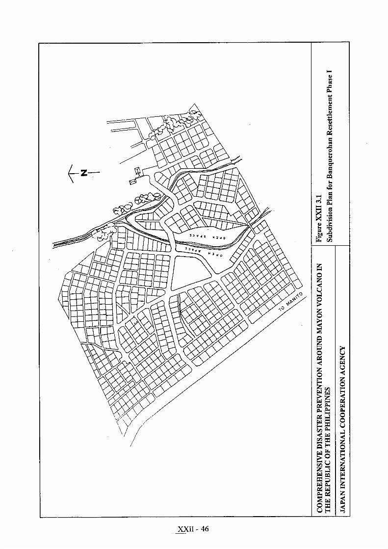
Of the given land use in the above, NHA-Region V Office generated 604residential lots and 24 commercial lots which are all located along the nationalroad. Since about 80% of the lots have already been constructed with core sheltersand about 504 units were already awarded. Phase I can already be considered asbuilt-up area. The subdivision plan for Banquerohan Phase I is shown in FigureXXII 3.1.
The commercial lots designated by NHA-Region V are lots whose frontages arelocated along the main provincial road. They are available to beneficiaries whoare capable of engaging in small-scale cottage industries or in other incomegenerating ventures. These lots were generated to produce income for thebeneficiaries and are therefore to be paid for by the awardees. The lot pricing forthese commercial lots is a bit higher than the regular lots inside the resettlementsite.
2) Banquerohan Phase II
Subdivision layout of Banquerohan Phase II is shown in Figure XXII 3.2. This27.07ha of resettlement site is still undeveloped, although NHA-Region V Officepointed out that they already introduced preliminary land development such assubdivision survey, construction of reinforced concrete box culverts, macadammain roads, sanitary units, and CHB-lined open canals.
For more than five years, there were no additional development undertaken tofully complete Phase II. At present, it is hard to recognize that the initialdevelopment was introduced in the site due to thick vegetation. From thedevelopment plans furnished by NHA-Region V, land use allocation is derivedand shown below:
Land Use Allocation for Banquerohan Phase II
Land Use Area (ha) %A. Buildable Area
1. Residential Lots 5.23 19.322. Commercial Lots 0.18 0.673. Reserve Residential 8.75 32.32
Subtotal 14.16 52.31B. Public and Common Area
1. Park 1.75 6.462. Circulation 2.33 8.613. Farm Lots 8.83 32.62
Subtotal 12.91 47.69Grand Total 27.07 100.00
Source: NHA-Region V Development Plan for Banquerohan Phase II
XXII - 21
The number of generated lots for residential and commercial purposes are 449 and11, respectively. Average sizes are almost the same with those in Phase I. Of the27.07ha land area, only 5.2ha or 19.3% (5.23ha/27.07ha) is allotted for residentialpurposes.
The area allotted for future residential development (reserve residential) can beused as production area. The parameter in computing the size of the productionarea was adopted from the existing resettlement sites of the NHA. On the average,about 60m2/household is used as factor in deriving the allocation for productionarea. The required land size for the production area is computed below:
Production Area = Expected number of households x 60m2/household= (600 [Phase I] + 460 [Phase II]) x 60m2
= 63,600m2 (6.36ha) for the whole Banquerohan area
With this revision, the resulting land use allocations is shown below:
Revised Land Use Allocation for Banquerohan Phase II
Land Use Area (ha) %
A. Buildable Area1. Residential Lots 5.23 19.322. Commercial Lots 0.18 0.673. Residential (Reserve) 2.39 8.83
Subtotal 7.80 28.82B. Public and Common Area
1. Open Space 1.75 6.462. Circulation 2.33 8.61
3. Farm Lots 8.83 32.624. Production Area 6.36 23.49
Subtotal 19.27 71.18Grand Total 27.07 100.00
Source: NHA-Region V Development Plan for Banquerohan Phase II
(2) Agricultural Land
1) Banquerohan Phase I
As shown in the previous table: Land Use Distribution of Banquerohan Phase I,the area does not have farm lots that can be used for agricultural purposes. Sincethe lot sizes ranges from 90 to 298m2, these lot sizes do not seem to be able tosustain a commercial level of backyard farming that can answer the daily needs ofthe beneficiaries.

XXII - 22
2) Banquerohan Phase II
The area allotted for agricultural lots is 8.8ha or about 32.51% (8.8ha/ 27.07ha) ofthe total area of Phase II, and about 19.13% (8.8ha/46ha) of the total area forPhases I and II.
Although the agricultural lots take up a substantial portion of the development, itis still not sufficient to accommodate the farm size requirements of all the farmerresettlers which may be given at 1.0ha per farming beneficiary. The prospectivebeneficiaries are the farmers already in Phase I and those expected to be resettledin Phase II.
The kinds of Projects Needed to be Implemented (refer to the table at page XXII-9) revealed that the provision of available farmland (15.3%) ranked fourth amongthe most expected projects being awaited by the beneficiaries. The on-farmproduction ranked second most beneficial kind of livelihood projects beingperceived by the resettlers and candidate resettlers.
For this reason, provision of farm lots to the farmer-resettlers adjacent to theresettlement site should be given emphasis. It is to be noted that the averageincome level of the interviewed households works out to about PHP3,500 permonth, according to the results of the People’s Intention Survey. The incomederived from agriculture accounts for 26.8% of the total income of the sampledhouseholds.
(3) Industrial Zone
1) Banquerohan Phase I
The development done by the NHA-Region V designated this site into purelyresidential-commercial-institutional area. The whole area has already beenconstructed with core housing units. The open spaces indicated in thedevelopment plans are located in steep slopes. With this given developmentconcept, much of the open spaces cannot be used for other purposes especially inthe allocation of industrial zones of productivity centers.
It would be noted that construction on very steep slopes would either be costly ormay pose danger on lives and properties in the near future. Hence, those areaswould have to be planted with trees and shrubs to prevent soil erosion. It isrecommended that existing development plans be followed and if communityfacilities are to be constructed, they should be located at the designated public areawhich is still has enough space.

XXII - 23
2) Banquerohan Phase II
Despite the absence of an area for industrial/productivity purposes in Phase I, thedevelopment of Banquerohan Phase II did not also take into consideration the saidrequirement. Phase II has an area allotted for school and an open area in Block 37(refer to Figure XXII 3.8). It also has an area for commercial lots located alongthe national road as well as a reserve area for residential use and area for farmlots.
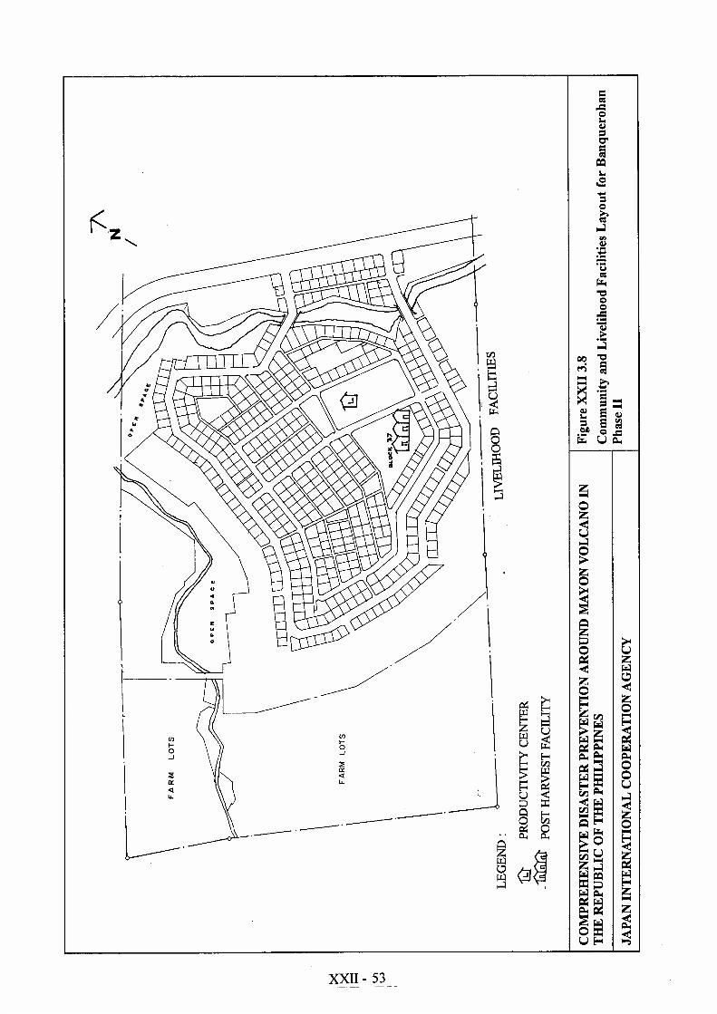
Based on this situation, it would be economically viable to put a single productionarea in Phase II which will serve the whole of Banquerohan Resettlement Site(Phase I & II). This production area will accommodate the productivity center,business center, showroom, skills training center, and other vital livelihoodfacilities.
The operation and maintenance would be centralized, thus minimizing onoverhead and operational expenses. This one-stop center set-up would be idealboth for trade promotion staff of the Government as well as the beneficiary-producer.
(4) Public and Common Area
1) Banquerohan Phase I
The topography of Phase I dictates that much of the area would have to be openspace. Steep slopes created mini-parks wherein residents use it for backyardfarming or just plain vegetation area. Moreover, a considerable area of about4,806m2 which is classified as unbuildable can be considered as open space.
Much of the steep terrain are already protected by boulder rip-rap. The total areafor parks and open space including unbuildable area is about 10.39 ha or 54.89%(10.39 ha/18.93 ha).
2) Banquerohan Phase II
Open spaces and pocket parks are provided in this site. Open spaces are providedin the easement of waterways that runs through the site. Steep slopes createdbigger open spaces. By classifying farm lots and reserved residential areas intoopen spaces, the total open spaces would have a total area of 21.66ha or about80.0% (21.66ha/27.07ha). Provision of open space is more than enough whichgives the site bigger circulation and production areas for beneficiaries.

XXII - 24
3.1.2 Infrastructures
(1) Road and Transportation Network
1) Banquerohan Phase I
The designs of roads and footpaths for the site conform to the low-costdevelopment guidelines of the NHA. The main roads intersect the national road ontwo points. All lots have access either through the main roads or the footpaths.
All the main roads and the footpaths were graded and compared as per NHAstandards. The total area of circulation network for Phase I is 2.52 ha or 13.31%(2.52ha/18.93ha) of the total area.
Types of Roads for Banquerohan Phase I & Phase II Resettlement Site
Sites Type of Road Right-of-Way(m) Pavement Carriage way Length
(m)BanquerohanPhase I Major/main 10.0 Macadam 6 478
Minor/secondary 8.0 Macadam 6 915
Path/alley 3.0 Compactedsubgrade 3 4,367
Banquerohan Major/main 10.0 Macadam 6 960Phase II Minor/secondary 8.0 Macadam 6 200
Service/tertiary 6.5 Macadam 5 663
Path/alley 3.0 Compactedsubgrade 3 2,597
2) Banquerohan Phase II
For Phase II, the circulation network is circumferential in design and has twoconnecting points at the national road. The design finish and the specifications areidentical to the road and path designs of Phase I. The total area of roads and pathsis 2.33 ha or about 8.61% (2.33 ha/27.07ha) of the total area of the Phase II site(refer to the above table).
(2) Water Supply System
The water supply being used in Banquerohan Phase I is shallow well. Of the 24shallow wells constructed in Phase I, only about 8 are in operation and theremaining are either destroyed or no longer capable of drawing groundwater. Theresidents get their water from spring which is continuously flowing in Phase II.The problem of water supply worsens during the dry season.
Since water supply is very unstable especially during the dry season, it isrecommended that the drilling of deep well be done for two sites. The minimumdepth of well is 150.0 m from the ground or until the aquifer in the locality is
XXII - 25
reached. The appurtenant components of deep well such as elevated water steeltanks, pumps, pipelines and communal faucets are to be included in the upgradingof the water supply system.
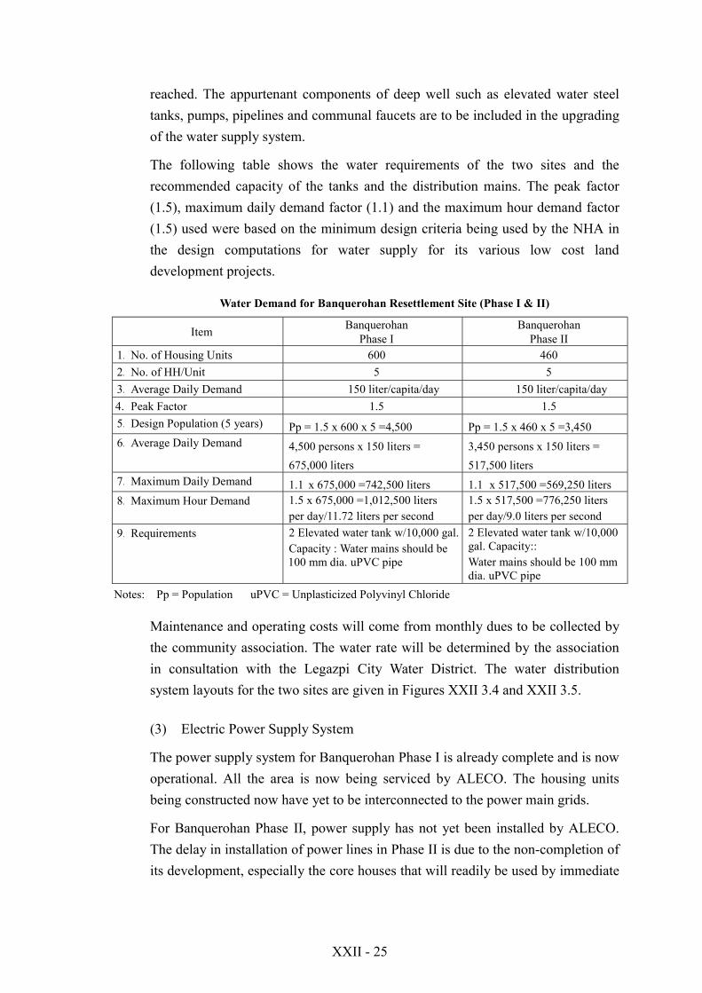
The following table shows the water requirements of the two sites and therecommended capacity of the tanks and the distribution mains. The peak factor(1.5), maximum daily demand factor (1.1) and the maximum hour demand factor(1.5) used were based on the minimum design criteria being used by the NHA inthe design computations for water supply for its various low cost landdevelopment projects.
Water Demand for Banquerohan Resettlement Site (Phase I & II)
Item BanquerohanPhase I
BanquerohanPhase II
1. No. of Housing Units 600 4602. No. of HH/Unit 5 53. Average Daily Demand 150 liter/capita/day 150 liter/capita/day4. Peak Factor 1.5 1.55. Design Population (5 years) Pp = 1.5 x 600 x 5 =4,500 Pp = 1.5 x 460 x 5 =3,4506. Average Daily Demand 4,500 persons x 150 liters =
675,000 liters3,450 persons x 150 liters =517,500 liters
7. Maximum Daily Demand 1.1 x 675,000 =742,500 liters 1.1 x 517,500 =569,250 liters8. Maximum Hour Demand 1.5 x 675,000 =1,012,500 liters
per day/11.72 liters per second1.5 x 517,500 =776,250 litersper day/9.0 liters per second
9. Requirements 2 Elevated water tank w/10,000 gal.Capacity : Water mains should be100 mm dia. uPVC pipe
2 Elevated water tank w/10,000gal. Capacity::Water mains should be 100 mmdia. uPVC pipe
Notes: Pp = Population uPVC = Unplasticized Polyvinyl Chloride
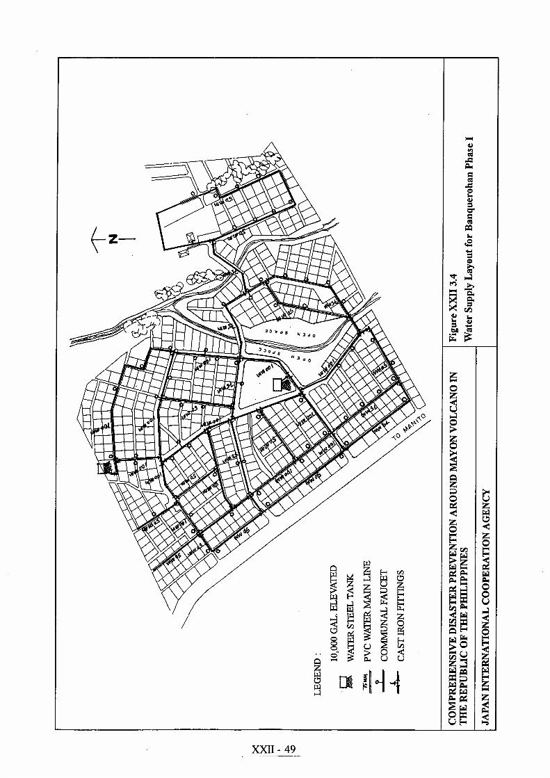
Maintenance and operating costs will come from monthly dues to be collected bythe community association. The water rate will be determined by the associationin consultation with the Legazpi City Water District. The water distributionsystem layouts for the two sites are given in Figures XXII 3.4 and XXII 3.5.
(3) Electric Power Supply System
The power supply system for Banquerohan Phase I is already complete and is nowoperational. All the area is now being serviced by ALECO. The housing unitsbeing constructed now have yet to be interconnected to the power main grids.
For Banquerohan Phase II, power supply has not yet been installed by ALECO.The delay in installation of power lines in Phase II is due to the non-completion ofits development, especially the core houses that will readily be used by immediate

XXII - 26
relocatees. The power supply system layout for Banquerohan is shown in FigureXXII 3.6.
The detailed design and analysis of the power reticulation system as well as theinstallation or upgrading of power supply will be carried out by the local electriccooperative. The following will be installed conforming with the design standardsor provisions of the Electrical Code of the Philippines.
! Street lighting! Utility poles and features! Wiring system
Transformer load schedule and computations are as follows:
! T-1 Transformer = 100kWh/month x 50 units
720hr/month x 0.8DF x 0.33PF x 125% SF = 32.881
- For T-1 Use: 1 to 37.5KVA, 7.62/0.24kV, single Phase, 60Hz steppeddown, oil immersed, self cooled outdoor power transformer
- For 460 lots, eight T-1 transformer and 1 with higher capacity (T-2) areneeded.
! T-2 Transformer = 100kWh/month x 60 units
720hr/month x 0.8DF x 0.33PF x 125% SF = 39.457
- For T-2 Use : 1 to 50KVA, 7.62/0.24kV, single phase, 60Hz steppeddown, oil immersed, self cooled outdoor power transformer
- Electrical code recommends the 2 to 100mm2 aluminum conductor steelreinforced cable be used for primary line. For secondary line the Coderecommends 2 to 50mm2 aluminum conductor steel reinforced cable.
! For Motor Transformer : 2 sets are required for overhead water tank.
- KVA Rating = 80AMP x 220V x /3
1000 x 125% = 38.10KVA
- As per Code requirements use 2 to 25KVA, single phase 7.62/0.24kVstepped down transformer open delta, three-phase bank
! Average power consumption of a resettlement unit per month =120 kilowatt-hour
Month
! Recommended number of units to be served by 1 transformer = 50 units
XXII - 27
! Average number of hours power is being utilized by a household in a month =720 hours/month
- 0.80DF = 80% Demand Factor (Electrical Code)- 0.33PF = 33% Power Factor (Electrical Code)- 125% SF = 125% Safety Factor
(4) Public Building
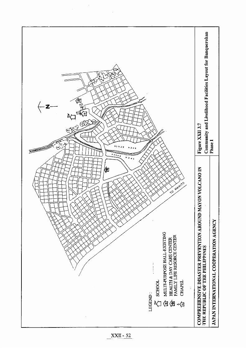
The proposed public buildings which will make up the community and livelihoodfacilities that will serve the beneficiaries of Banquerohan Resettlement Site arepresented in Figures XXII 3.7 and 3.8. The basic components and schematiclayout of the basic buildings are briefly discussed in the following sections.
1) Elementary School Building
The provision of elementary school facilities for Banquerohan is a must to arrestthe rising incidence of illiteracy and attract future resettlers in the site. TheBanqerohan elementary school which is the lone barangay school is 1.5km awayfrom the resettlement site. From the data furnished by DECS-Region V,Banquerohan elementary school has the following student profile and facilities:
Profile and Facilities of Banquerohan Elementary School
Level No. of Students No. of Classrooms- Primary (I – IV) 704 17- Intermediate (V – VI) 325 8
TOTAL 1,029 25
Source : DECS – Region V
This student population comes from the total barangay population of 5,412persons according to latest DSWD-Legazpi City statistics. Correlating the dataabove to the expected number of families that will be relocated to BanquerohanResettlement sites (Phase I and Phase II) is more than 1,000 families. It isrecommended that a 25-classroom school will have to be constructed in thegovernment site of Banquerohan Phase I.
In addition to the 25 classrooms, non-academic rooms will have to be providedsuch as principal’s office, library, faculty room and cafeteria. This school will alsohandle the enrolees coming from adjacent barangays who will find this schoolmore convenient. The proposed layout is shown in Figure XXII 3.9.
XXII - 28
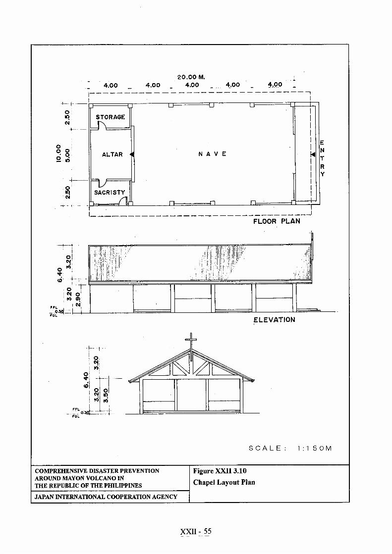
2) Chapel
The chapel design and its size is likely the same with the one constructed andalready being used in Banquerohan Phase I. The layout and the dimensions areshown in XXII 3.10. The floor area requirement for this chapel is 233m2 (10m x23.3m). The proposed lot area requirement for this facility is about 1,500m2 (30mx 50m).
Since there is already an existing chapel in Phase I, it is worth to consider theexpansion of this chapel so that it can adequately serve the residents of both PhaseI & II of Banquerohan resettlement site.
3) Public Hall/Multi-Purpose Hall
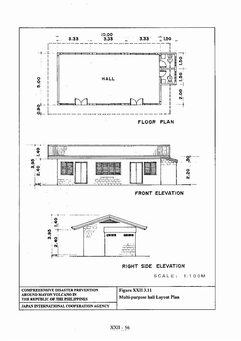
This building is planned to serve as venue for the beneficiaries and the localgovernment personnel to conduct outreach seminars, training and other importantmeetings. This could also serve as barangay outpost during night time. Theplanned size of the multi-purpose hall is about 55.0m2. This floor area is theregular size of public hall being constructed by NHA in some of its developedresettlement sites. Barangay halls in rural areas have the same size asrecommended.
This multi-purpose hall is proposed to be built in Banquerohan Phase II andAnislag resettlement sites. The typical building layout and its dimensions areshown in Figure XXII 3.11.
4) Others
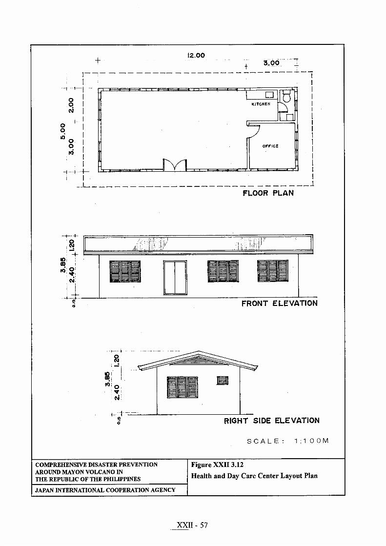
a. Health and Day Care Center
This community facility is proposed to be built in Anislag resettlement site.This facility is planned with an area of 60m2. The size adopted conforms tothe existing floor area of barangay health facilities already constructed byNHA in its resettlement/relocation sites. It is provided with and office,kitchen and single toilet.
This center is dual in use. One half can be a day care center while the otherhalf can be the clinic/check-up area to be used by visiting doctor or healthworker. The health center can be installed with three hospital beds in case ofemergency. The typical building layout for this type of building is shown inFigure XXII 3.12.
XXII - 29
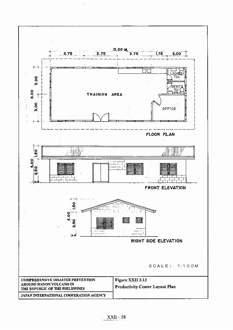
b. Productivity Center
The productivity center is envisioned to be the venue for livelihood andskills training for the beneficiaries. The conduct of training is in line with thelocal government thrust of providing livelihood opportunities to majority ofthe people living in the resettlement sites. The building is provided withample floor area for training, big kitchen area for demonstration, office forlivelihood officers and two big toilets. This building measures about 90m2.
For the training area, large working tables (quantity: 6) and monobloc plasticchairs shall be provided for the trainees. Big display cabinets shall also beprovided to showcase the quality and variety of goods being produced in thesite. A 21 inches colored television including a VHS player will be providedto be used solely for skills training, demonstration and technology transfer.Floor layout and elevations are shown in Figure XXII 3.13.
c. Multi-purpose Warehouse
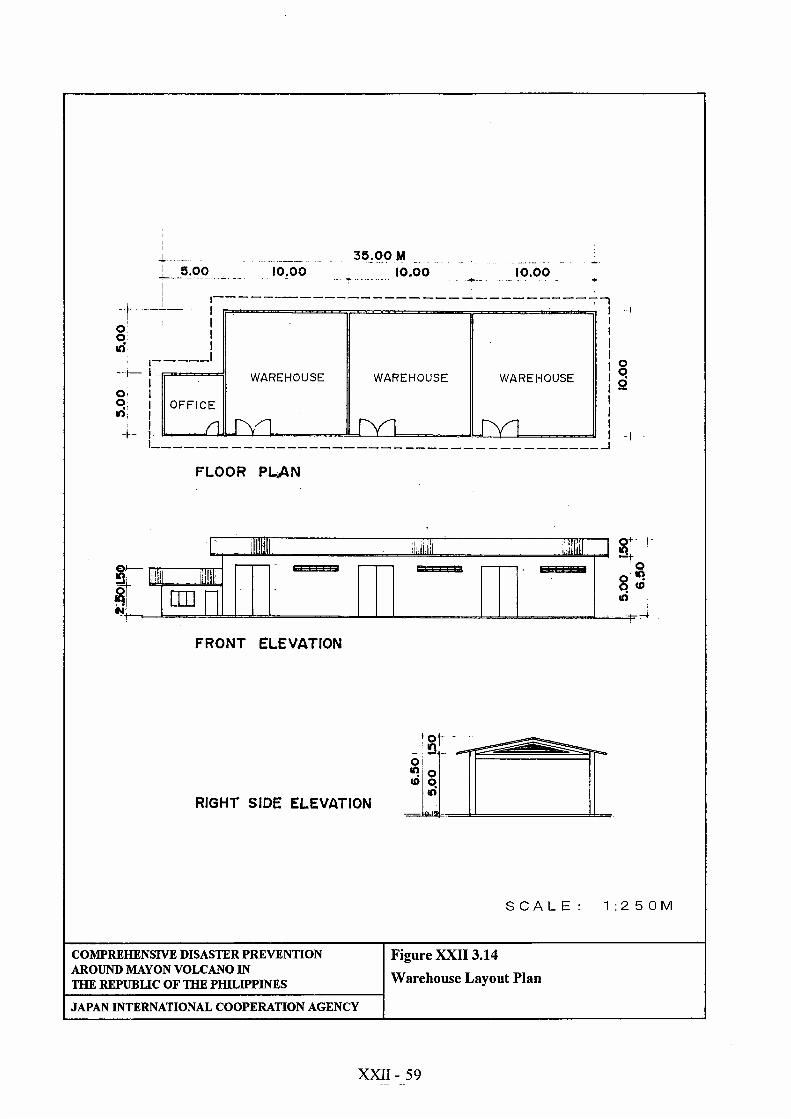
This warehouse will be used by recognized resettlers’ cooperative orcommunity association. They will be the one to identify goods that will bestored in every compartment. Storage fees will be paid to the cooperative/association the rate of which shall be determined by all members. The site ofthis warehouse shall be high enough so that flood would not reach the floor.
This building is a component of the livelihood support package for thebeneficiaries. This will enable the users to place the goods safely especiallyduring wet season and in the event of typhoons. The building is an all-weather structure and capable of withstanding super typhoons. It has threebig compartments so that a variety of goods can be stored at the same time.The area of the warehouse is about 325m2 including the office of thecaretaker. The floor layout and elevations are shown in Figure XXII 3.14.
With a given area of 300m2, the volume of warehouse is about 1,500m3
(300m2 x 5.0m height) at 80% maximum allowable space, the holdingcapacity of the warehouse is about 1,200m3 (1,500m3 x 0.80). The requiredarea proposed (300m2) is good enough to meet the emergency storage needsof resettlers.
3.1.3 Housing Lot Plan
The design standards for “new resettlement scheme” proposed by the JICA StudyTeam are the following.
XXII - 30
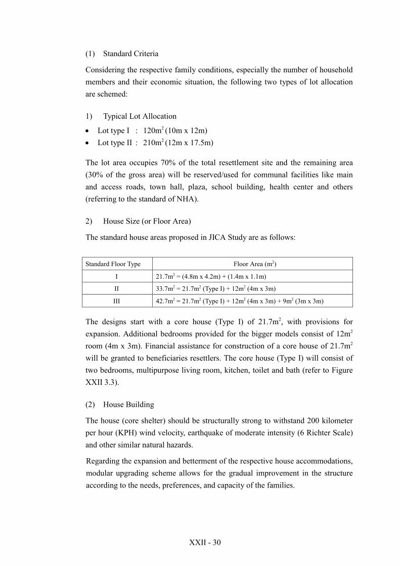
(1) Standard Criteria
Considering the respective family conditions, especially the number of householdmembers and their economic situation, the following two types of lot allocationare schemed:
1) Typical Lot Allocation
! Lot type I : 120m2 (10m x 12m)! Lot type II : 210m2 (12m x 17.5m)
The lot area occupies 70% of the total resettlement site and the remaining area(30% of the gross area) will be reserved/used for communal facilities like mainand access roads, town hall, plaza, school building, health center and others(referring to the standard of NHA).
2) House Size (or Floor Area)
The standard house areas proposed in JICA Study are as follows:
Standard Floor Type Floor Area (m2)
I 21.7m2 = (4.8m x 4.2m) + (1.4m x 1.1m)
II 33.7m2 = 21.7m2 (Type I) + 12m2 (4m x 3m)
III 42.7m2 = 21.7m2 (Type I) + 12m2 (4m x 3m) + 9m2 (3m x 3m)
The designs start with a core house (Type I) of 21.7m2, with provisions forexpansion. Additional bedrooms provided for the bigger models consist of 12m2
room (4m x 3m). Financial assistance for construction of a core house of 21.7m2
will be granted to beneficiaries resettlers. The core house (Type I) will consist oftwo bedrooms, multipurpose living room, kitchen, toilet and bath (refer to FigureXXII 3.3).
(2) House Building
The house (core shelter) should be structurally strong to withstand 200 kilometerper hour (KPH) wind velocity, earthquake of moderate intensity (6 Richter Scale)and other similar natural hazards.
Regarding the expansion and betterment of the respective house accommodations,modular upgrading scheme allows for the gradual improvement in the structureaccording to the needs, preferences, and capacity of the families.
XXII - 31
3.2 Anislag Resettlement Site
3.2.1 Land Use Layout (Area Development Plan)
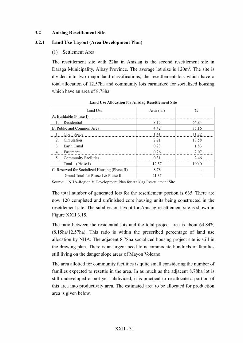
(1) Settlement Area
The resettlement site with 22ha in Anislag is the second resettlement site inDaraga Municipality, Albay Province. The average lot size is 120m2. The site isdivided into two major land classifications; the resettlement lots which have atotal allocation of 12.57ha and community lots earmarked for socialized housingwhich have an area of 8.78ha.
Land Use Allocation for Anislag Resettlement Site
Land Use Area (ha) %A. Buildable (Phase I)
1. Residential 8.15 64.84B. Public and Common Area 4.42 35.16
1. Open Space 1.41 11.222. Circulation 2.21 17.583. Earth Canal 0.23 1.834. Easement 0.26 2.075. Community Facilities 0.31 2.46
Total (Phase I) 12.57 100.0C. Reserved for Socialized Housing (Phase II) 8.78 -
Grand Total for Phase I & Phase II 21.35 -Source: NHA-Region V Development Plan for Anislag Resettlement Site
The total number of generated lots for the resettlement portion is 635. There arenow 120 completed and unfinished core housing units being constructed in theresettlement site. The subdivision layout for Anislag resettlement site is shown inFigure XXII 3.15.
The ratio between the residential lots and the total project area is about 64.84%(8.15ha/12.57ha). This ratio is within the prescribed percentage of land useallocation by NHA. The adjacent 8.78ha socialized housing project site is still inthe drawing plan. There is an urgent need to accommodate hundreds of familiesstill living on the danger slope areas of Mayon Volcano.
The area allotted for community facilities is quite small considering the number offamilies expected to resettle in the area. In as much as the adjacent 8.78ha lot isstill undeveloped or not yet subdivided, it is practical to re-allocate a portion ofthis area into productivity area. The estimated area to be allocated for productionarea is given below.
XXII - 32
Estimated Lot Size for Production Area =
Estimated No. of Households (635) x 60m2 = 38,100m2
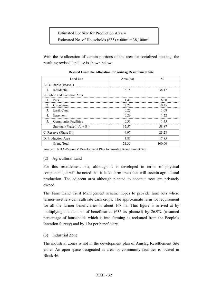
With the re-allocation of certain portions of the area for socialized housing, theresulting revised land use is shown below:
Revised Land Use Allocation for Anislag Resettlement Site
Land Use Area (ha) %
A. Buildable (Phase I)1. Residential 8.15 38.17
B. Public and Common Area1. Park 1.41 6.602. Circulation 2.21 10.353. Earth Canal 0.23 1.084. Easement 0.26 1.22
5. Community Facilities 0.31 1.45Subtotal (Phase I: A. + B.) 12.57 58.87
C. Reserve (Phase II) 4.97 23.28
D. Production Area 3.81 17.85Grand Total 21.35 100.00
Source: NHA-Region V Development Plan for Anislag Resettlement Site
(2) Agricultural Land
For this resettlement site, although it is developed in terms of physicalcomponents, it will be noted that it lacks farm areas that will sustain agriculturalproduction. The adjacent area although planted to coconut trees are privatelyowned.
The Farm Land Trust Management scheme hopes to provide farm lots wherefarmer-resettlers can cultivate cash crops. The approximate farm lot requirementfor all the farmer beneficiaries is about 168 ha. This figure is arrived at bymultiplying the number of beneficiaries (635 as planned) by 26.9% (assumedpercentage of households which is into farming as reckoned from the People’sIntention Survey) and by 1 ha per beneficiary.
(3) Industrial Zone
The industrial zones is not in the development plan of Anislag Resettlement Siteeither. An open space designated as area for community facilities is located inBlock 46.
XXII - 33
Areas to be used for livelihood purposes such as production areas and productivitycenter would most likely be situated in the still undeveloped socialized housingsite or from the acquisition of adjacent private lands by the Local Government
(4) Public and Common Area
The site is not provided with ample open space and parks as compared with thetwo other sites (Banquerohan Phases I and II). The site is maximized in terms oflot generation for residential use. It allocated a space for community facilities atBlock 46. The total area for open space is 4.42ha or 35.16% (4.42ha/12.57ha) ofthe total project area. This is still within the prescribed development standards ofthe NHA. However, this is still small when the need for socio-economiccomponents are considered.
3.2.2 Infrastructures
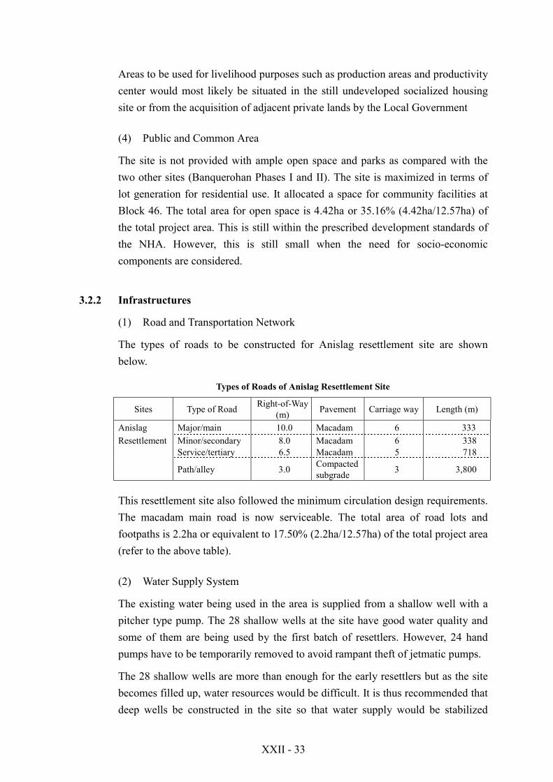
(1) Road and Transportation Network
The types of roads to be constructed for Anislag resettlement site are shownbelow.
Types of Roads of Anislag Resettlement Site
Sites Type of Road Right-of-Way(m) Pavement Carriage way Length (m)
Anislag Major/main 10.0 Macadam 6 333Resettlement Minor/secondary 8.0 Macadam 6 338
Service/tertiary 6.5 Macadam 5 718
Path/alley 3.0 Compactedsubgrade 3 3,800
This resettlement site also followed the minimum circulation design requirements.The macadam main road is now serviceable. The total area of road lots andfootpaths is 2.2ha or equivalent to 17.50% (2.2ha/12.57ha) of the total project area(refer to the above table).
(2) Water Supply System
The existing water being used in the area is supplied from a shallow well with apitcher type pump. The 28 shallow wells at the site have good water quality andsome of them are being used by the first batch of resettlers. However, 24 handpumps have to be temporarily removed to avoid rampant theft of jetmatic pumps.
The 28 shallow wells are more than enough for the early resettlers but as the sitebecomes filled up, water resources would be difficult. It is thus recommended thatdeep wells be constructed in the site so that water supply would be stabilized
XXII - 34
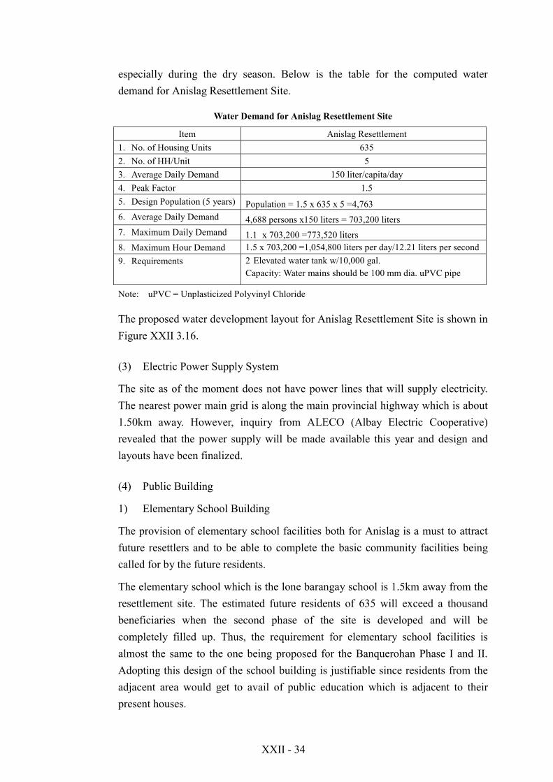
especially during the dry season. Below is the table for the computed waterdemand for Anislag Resettlement Site.
Water Demand for Anislag Resettlement Site
Item Anislag Resettlement1. No. of Housing Units 6352. No. of HH/Unit 53. Average Daily Demand 150 liter/capita/day4. Peak Factor 1.55. Design Population (5 years) Population = 1.5 x 635 x 5 =4,7636. Average Daily Demand 4,688 persons x150 liters = 703,200 liters7. Maximum Daily Demand 1.1 x 703,200 =773,520 liters8. Maximum Hour Demand 1.5 x 703,200 =1,054,800 liters per day/12.21 liters per second9. Requirements 2 Elevated water tank w/10,000 gal.
Capacity: Water mains should be 100 mm dia. uPVC pipe
Note: uPVC = Unplasticized Polyvinyl Chloride
The proposed water development layout for Anislag Resettlement Site is shown inFigure XXII 3.16.
(3) Electric Power Supply System
The site as of the moment does not have power lines that will supply electricity.The nearest power main grid is along the main provincial highway which is about1.50km away. However, inquiry from ALECO (Albay Electric Cooperative)revealed that the power supply will be made available this year and design andlayouts have been finalized.
(4) Public Building
1) Elementary School Building
The provision of elementary school facilities both for Anislag is a must to attractfuture resettlers and to be able to complete the basic community facilities beingcalled for by the future residents.
The elementary school which is the lone barangay school is 1.5km away from theresettlement site. The estimated future residents of 635 will exceed a thousandbeneficiaries when the second phase of the site is developed and will becompletely filled up. Thus, the requirement for elementary school facilities isalmost the same to the one being proposed for the Banquerohan Phase I and II.Adopting this design of the school building is justifiable since residents from theadjacent area would get to avail of public education which is adjacent to theirpresent houses.

XXII - 35
2) Chapel
The chapel design and its size is likely the same with the one constructed andalready being used in Banquerohan Phase I. The layout and the dimensions areshown in Figure XXII 3.8. The floor area requirement for this chapel is 233m2
(10m x 23.3m). The proposed lot area requirement for this facility is about1,500m2 (30m x 50m). As to the dimensions, they are based on the existing chapelin Banquerohan Phase I.
3) Public Hall/Multi-purpose Hall
This building planned to serve as venue for the beneficiaries and the localgovernment personnel to conduct outreach seminars, training and other importantmeetings. This could also as barangay outpost during night time. The planned sizeof the multi-purpose hall is about 55.0m2. This floor area is the regular size ofpublic hall being constructed by NHA in some of its developed resettlement sites.Barangay halls in rural areas have the same size as recommended.
4) Others
a. Health and Day Care Center
This community facility is proposed to be built in Anislag resettlement site.This facility is planned with an area of 60m2. The size adopted conforms tothe existing floor area of barangay health facilities already constructed byNHA in its resettlement/relocation sites. It is provided with and office,kitchen and single toilet.
This center is dual in use. The other half can be a day care center while theother half can be the clinic/check-up area to be used by visiting doctor orhealth worker. The health center can be installed with three hospital beds incase of emergency.
b. Productivity Center
The productivity center is envisioned to be the venue for livelihood andskills training for the beneficiaries. The conduct of training is in line with thelocal government thrust of providing livelihood opportunities to majority ofthe people living in the resettlement sites. The building is provided withample floor area for training, big kitchen area for demonstration, office forlivelihood officers and two big toilets. This building measures about 90m2.

XXII - 36
The productivity center is proposed to be constructed on the open area whichis part of the Phase II of Anislag. Refer to XXII 3.17 for the proposed layoutof basic community and livelihood facilities for Anislag Resettlement Site.
c. Multi-purpose Warehouse
As discussed in the proposed warehouse to be used for the Banquerohanresettlement sites, this design can be adopted to enable farmers to have adurable storage space especially during strong typhoons. This warehousewill be used by recognized resettlers’ cooperative or community association.They will be the one to identify goods that will be stored in everycompartment. Storage fees will be paid to the cooperative/association, therate of which will be determined by all members. The site of this warehousewill be high enough so that a flood would not reach the floor. It should alsobe accessible to farmers and also to buyers.
3.2.3 Housing Lot Plan
The design standards proposed by the JICA Study Team for BanquerohanResettlement Site development will be also applied to Anislag Resettement Sitedevelopment. For detailed information, refer to the previous Section 3.1.3. As tothe standard housing layout plan, refer to Figure XXII 3.3.
4. PRELIMINARY STRUCTURAL DESIGN
4.1 Banquerohan Resettlement Site (Phase I & II)
(1) Infrastructures
1) Road and Transportation Network
The existing roads and alleys for the resettlement sites are all made up ofcompacted subgrade with no all-weather pavement on it. The macadam roads arethe most easily adopted type of road being implemented in any relocation site ofthe government. Though it wears easily, repair can be easily done by the barangaysince the materials are available within the site.
However, the fast development of the community warrants the introduction of anall-weather asphaltic-based paving material for the main roads (10.0m R.O.W.)which will help reduce the erosion of subgrade base of the road and enhance theflow of traffic within the relocation site.

XXII - 37
For the paths and alleys, concrete paving blocks can be easily manufactured by thebarangay. The ideal size of the paving block is about 0.3m x 0.3m x 0.05m thick.This paving block can then be laid on compacted subgrade of the path walks.
2) Water Supply System
The layout plans for the water supply for Banquerohan Phases I and II arepresented in Figures XXII 3.4 and XXII 3.5. The deep wells to be drilled in thesite will be used as water source for the elevated water tanks. Centrifugal pumpswill be used for drawing underground water and raise it to the elevated tanks.
Stored water in the tanks will then be distributed using plastic pipes (PolyvinylChloride pipes). Cast iron fittings such as gate valves, tees, cross tees will have tobe used to control water flow.
Communal faucets will then be installed from which the residents can get theirsupply of potable water. At least 10 residents will be using one communal faucetfor their domestic water needs.
3) Electric Power Supply System
The layout plans for the electrical power supply is presented in Figure XXII 3.6.The layout shows the transformer requirement as well as the pole and wires to beused.
The electric power layout plans was made to ascertain the cost of energizing theBanquerohan Phase II site.
4) Sanitary System
The existing sanitary layout for Banquerohan Phase I and II needs upgrading andrehabilitation respectively. The toilets constructed in Phase I were proposed toserve four residents per toilet. The toilets were therefore communal in use. Theproblem with this kind of set up is the quick deterioration of the facility and themanner of the usage among the beneficiaries.
Whereas for Phase II, the constructed septic tanks were already destroyed beyondrepair. Complete rehabilitation will have to be done for the sanitary system to befunctional and become useful for future resettlers.
5) Access Roads
Residents of Banquerohan Phase I have no direct access to the coastal areas.Those that wish to engage in fishing have to traverse a 1.0m. wide trail leading tothe coastal area. The path is about 1.5km long and bringing of goods to and from

XXII - 38
the coastal area is rather difficult and does not encourage residents to venture inaquaculture development.
It is recommended, therefore, to provide wider access roads connecting theresettlement site to the coastal area. This will open up new avenue for theresidents contemplating of going into fishing business or any related endeavors.The government can therefore establish training facility for aquaculturedevelopment.
(2) Housing Lot
The recommended lot size to be able for a family to have ample space forimprovement is about 120m2. This lot area may have dimension of 10m x 12m onthe average.
(3) House Building
The (Type I) core house with an area of 21.7m2 provisions for expansion.Additional bedrooms provided for the bigger models consist of 12m2 room (4m x3m). Financial assistance for construction of a core house of 21.7m2 will begranted to beneficiaries resettlers. The core house (Type I) will consist of twobedrooms, multipurpose living room, kitchen, toilet and bath.
Regarding the expansion and betterment of the respective house accommodations,modular upgrading scheme allows for the gradual improvement in the structureaccording to the needs, preferences, and capacity of the families.

XXII - 39
(4) Work Volume
Banqurohan Resettlement Site (Phase I & II)
Item Phase I Phase IICommunity Facilities1. School Building 1 unit -2. Chapel - -3. Multi-purpose Hall - 1 unit4. Health & Day Care - -5. Productivity Center - 1 unit6. Warehouse - 1 unitInfrastructure1. Core housing units 96 units 460 units2. Water Supply Refer to Table XXIV 3.6 Refer to Table XXIV 3.63. Power Supply - Refer to Table XXIV 3.74. Circulation -
- Major road Refer to Table XXIV 3.9 Refer to Table XXIV 3.9- Alleys Refer to Table XXIV 3.9 Refer to Table XXIV 3.9
5. Drainage 8,000m 6,700m6. Site Clearing - 5,640m2
7. Sanitary System 474 units 460 units8. Access Roads Refer to Table XXIV 3.9 -
4.2 Anislag Resettlement Site
(1) Infrastructures
1) Road and Transportation Network
The existing roads and alleys for the resettlement sites are all made up ofcompacted subgrade with no all-weather pavement on it. The macadam roads arethe most easily adopted type of road being implemented in any relocation site ofthe government. Though it wears easily, repair can be easily done by the barangaysince the materials are available within the site.
In order to provide easy and smooth access from the main provincial road to theresettlement site, it is recommended that the barangay access road which leads tothe site be paved with all-weather asphaltic-based paving materials. This will helpneighboring barangays as well and delivery of goods to and from the site moreconveniently. Living conditions of the residents in the site as well as the adjacentcommunities will be benefited.
For the paths and alleys, concrete paving blocks can be easily manufactured by thebarangay. The ideal size of the paving block is about 0.3m x 0.3m x 0.05m thick.This paving block can then be laid on compacted subgrade of the paths.
XXII - 40
2) Water Supply System
The layout plans for the water supply for Anislag resettlement site is presented inFigure XXII 3.16. The deep wells to be drilled in the site will be used as watersource for the elevated water tanks. Centrifugal pumps will be used for drawingunderground water and raise it to the elevated tanks.
Stored water in the tanks will then be distributed using plastic pipes (PolyvinylChloride pipes). Cast iron fittings such as gate valves, tees, cross tees will have tobe used to control water flow. Communal faucets will then be installed fromwhich the residents can get their supply of potable water. At least 10 residents willbe using one communal faucet for their domestic water needs.
3) Electric Power Supply System
The layout plans for electrical power supply system will be provided by ALECO.
The costing and the materials requirements for the project is already prepared andjust awaiting the actual implementation by the concerned agency.
4) Sanitary System
The sanitary system for Anislag resettlement site is already complete and is nowbeing used by the residents themselves. Each unit has its own toilet unlike inBanquerohan Phase I where about 4 residents share the use of 1 toilet.
The development of sanitary system for Anislag is a septic tank type wherein theresidents will just provide a toilet bowl and construct their own toilet. With thismode of construction, residents will have a closer maintenance of their respectiveunits.
(2) Housing Lot
As recommended for Banquerohan Phase I and II, the lot size of 120m2 is the lotarea which was adopted in the lot distribution for Anislag site.
The (Type I) core house with an area of 21.7m2 provisions for expansion.Additional bedrooms provided for the bigger models consist of 12m2 room (4m x3m). The core house (Type I) will consist of two bedrooms, multipurpose livingroom, kitchen, toilet and bath.
Regarding the expansion and betterment of the respective house accommodations,modular upgrading scheme allows for the gradual improvement in the structureaccording to the needs, preferences, and capacity of the families.

XXII - 41
(4) Work Volume
Anislag Resettlement Site
Item TotalCommunity Facilities1. School Building 1 unit2. Chapel 1 unit3. Multi-purpose Hall 1 unit4. Health & Day Care 1 unit5. Productivity Center 1 unit6. Warehouse 1 unitInfrastructure1. Core housing units 505 units2. Water Supply Refer to Table XXIV 3.63. Power Supply -4. Circulation -
- Major road -- Alleys -
5. Drainage -6. Site Clearing -7. Sanitary System -8. Access Roads Refer to Table XXIV 3.9
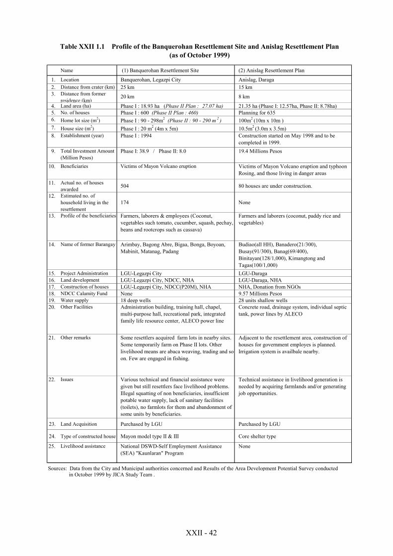
XXII - 42
Name (1) Banquerohan Resettlement Site (2) Anislag Resettlement Plan
1. Location Banquerohan, Legazpi City Anislag, Daraga2. Distance from crater (km) 25 km 15 km3. Distance from former
residence (km)20 km 8 km
4. Land area (ha) Phase I : 18.93 ha (Phase II Plan : 27.07 ha) 21.35 ha (Phase I: 12.57ha, Phase II: 8.78ha)5. No. of houses Phase I : 600 (Phase II Plan : 460) Planning for 6356. Home lot size (m2) Phase I : 90 - 298m2 (Phase II : 90 - 290 m 2 ) 100m2 (10m x 10m )7. House size (m2) Phase I : 20 m2 (4m x 5m) 10.5m2 (3.0m x 3.5m)8. Establishment (year) Phase I : 1994 Construction started on May 1998 and to be
completed in 1999.9. Total Investment Amount
(Million Pesos)Phase I: 38.9 / Phase II: 8.0 19.4 Millions Pesos
10. Beneficiaries Victims of Mayon Volcano eruption Victims of Mayon Volcano eruption and typhoonRosing, and those living in danger areas
11. Actual no. of housesawarded 504 80 houses are under construction.
12. Estimated no. ofhousehold living in theresettlement
174 None
13. Profile of the beneficiaries Farmers, laborers & employees (Coconut,vegetables such tomato, cucumber, squash, pechay,beans and rootcrops such as cassava)
Farmers and laborers (coconut, paddy rice andvegetables)
14. Name of former Barangay Arimbay, Bagong Abre, Bigaa, Bonga, Boyoan,Mabinit, Matanag, Padang
Budiao(all HH), Banadero(21/300),Busay(91/300), Banag(69/400),Binitayan(128/1,000), Kimangtong andTagas(100/1,000)
15. Project Administration LGU-Legazpi City LGU-Daraga16. Land development LGU-Legazpi City, NDCC, NHA LGU-Daraga, NHA17. Construction of houses LGU-Legazpi City, NDCC(P20M), NHA NHA, Donation from NGOs18. NDCC Calamity Fund None 9.57 Millions Pesos19. Water supply 18 deep wells 28 units shallow wells20. Other Facilities Administration building, training hall, chapel,
multi-purpose hall, recreational park, integratedfamily life resource center, ALECO power line
Concrete road, drainage system, individual septictank, power lines by ALECO
21. Other remarks Some resettlers acquired farm lots in nearby sites.Some temporarily farm on Phase II lots. Otherlivelihood means are abaca weaving, trading and soon. Few are engaged in fishing.
Adjacent to the resettlement area, construction ofhouses for government employes is planned.Irrigation system is availbale nearby.
22. Issues Various technical and financial assistance weregiven but still resettlers face livelihood problems.Illegal squatting of non beneficiaries, insufficientpotable water supply, lack of sanitary facilities(toilets), no farmlots for them and abandonment ofsome units by beneficiaries.
Technical assistance in livelihood generation isneeded by acquiring farmlands and/or generatingjob opportunities.
23. Land Acquisition Purchased by LGU Purchased by LGU
24. Type of constructed house Mayon model type II & III Core shelter type
25. Livelihood assistance National DSWD-Self Employment Assistance(SEA) "Kaunlaran" Program
None
Sources: Data from the City and Municipal authorities concerned and Results of the Area Development Potential Survey conducted in October 1999 by JICA Study Team .
Table XXII 1.1 Profile of the Banquerohan Resettlement Site and Anislag Resettlement Plan(as of October 1999)