surface deformation and tectonic setting of taiwan ... · surface deformation and tectonic setting...
TRANSCRIPT

Chapter 3
Surfacedeformation and tectonicsettingof Taiwan inferr ed fr om aGPSvelocity field.
3.1�
Intr oduction
The�
islandof Taiwan is a zoneof active continentaldeformationlocatedin anexcep-tional�
tectonicsettingwithin theplateboundaryzonebetweentheEurasianPlate(EUP)and� the Phillipine SeaPlate(PSP)(figure3.1). At Taiwan thePSPis moving towardthe�
EUPat a rateof 70-80mm/yr in thedirectionN306� E (Senoet al., 1993,insetoffigure�
3.1). Thecomplexity of Taiwan’s tectonicsettingarisesfrom thefactthatat theRyuk�
yu Trenchthe PSPsubductsnorthnorthwestward underneaththe EUP, whereasat� the Manila Trenchthe PSPoverridesthe EUP in a westward direction. Taiwan islocatedat the transferzonebetweensubductionandoverriding of the PSP. The 150km�
long, NNE-trendingLongitudinalValley Fault (LVF) on the islandof Taiwan isgenerally� consideredasthesuturezonebetweenthetwo plates(BarrierandAngelier,1986;Biq, 1972)accountingfor 25-30% of thetotalplateconvergence(Angelieretal.,2000).
The�
still ongoingcollision betweentheLuzonvolcanicarcandtheChineseconti-nental margin startedat least8Myr ago(Ho, 1988;Kao et al., 1998;Lallemandet al.,2001;Teng,1990)therebycreatingandbuilding theTaiwanorogen.Dueto theobliqueorientation� of thestrike of thearcrelative to thestrike of thepassive margin, thecolli-sion� at Taiwanhasmigratedsouthward,incorporatingever new portionsof theLuzonarc� (Lewis andHayes,1983;Suppe,1981). Detailsof thegeodynamicevolution andpresent-day tectonicsettingof Taiwan areby no meansresolved. This becomesevi-
Thischapteris in pressfor publicationin J�. Geoph.Res.as:A.G. Bos,W. SpakmanandM.C.J.Nyst,
Surfacedeformationandtectonicsettingof Taiwaninferredfrom aGPSvelocity field.
47

48 Chapter3
dent�
from thevarietyof contradictingmodelsproposedin theliterature(Angelieretal.,1990;Chemendaetal., 1997;Lu andMalavieille, 1994;Suppe,1981;Teng,1990;Wuet� al., 1997).Suppe,1981;Teng,1990;Wu etal., 1997].
These�
modelsfocuson two closelyrelatedprocesses:thegeometryanddynamicsof� thetransitionbetweenthetwo subductionzonesandtheevolutionof theTaiwanoro-gen.� Thehypothesisof the”thin-skinned”or ”critical taper”model(Barr andDahlen,1990;Dahlen,1990)for actively deformingfold-and-thrustbeltshasbeenchallengedby�
modelsincluding thebasementof thecrustin themountainbuilding process(Ell-w� ood et al., 1996;HwangandWang,1993;Wu et al., 1997). In the ”thin-skinned”models� activedeformationis confinedto a trapezoidalsegmentof awedgeoverlyingaplanar decollementfault,whereasthe”basementinvolved” modelsrequirethediscreteincorporationof autochthonousbasementmaterialinto theshallow partsof theorogen.A modelof crustalsubductionfollowed by exhumation(Chemendaet al., 2001;Lin,1998;Lin et al., 1998)hasalsobeenproposedto explain therapiduplift andhigh heatflo�
w in the CentralRangeof Taiwan (figure 3.1). Lallemandet al. (1997,2001)andTengetal. (2000)proposedetachmentof theEurasianslabbeneathTaiwanasamecha-nismto createspacefor thesubductionof thePSPslabalongthewestwardpropagatingRyuk�
yu trench. Analoguemodelinghasshown the possibility of subductionreversalalong� aboundarycomparableto theLVF of Taiwanin asimilarsettingof two contrarysubduction� zones,aswell asprovidedinsight in themechanismsbehindtheprocessesof� exhumationandlateralextrusion(Chemendaetal., 1997,2001;Lu andMalavieille,1994).Theseandothermodelsstill requirefurthertestingagainstavailablegeological,geophysical� and,in particular, geodeticdataacquiredin thepastdecade.
In 1989the”TaiwanGPSNetwork” wasestablishedby theInstituteof EarthSci-ences,� AcademicaSinica(IESAS).Basedon the 1990-1995dataof the network, Yuet� al. (1997)derivedthepresent-dayvelocity field of theTaiwanarea.Sucha velocityfield providessignificantinformationon the kinematicsof the crustaldeformation.Iapply� theinversionmethodof SpakmanandNyst(2002)to theGPSvelocityfield of Yuet� al. (1997)in orderto determinethekinematicpropertiesof thesurfacedeformation.This methodsolvessimultaneouslyfor the velocity gradientfield andfault slip rate.TheSpakmanandNyst (2002)methodutilizesaphysicalrelationbetweenthevelocitygradient� field, faultmotionandtherelativevelocitydatawhichis significantlydifferentfrom�
similarstudiesoncomplicatedregionswhicharebasedonspatialinterpolationofthe�
data(e.g.Beavan andHaines,2001;Wdowinski et al., 2001). The incorporationof� fault motion in a joint inversionwith the velocity gradientfield is a uniquechar-acteristic� of the method. In contrastto for instanceelasticdislocationmodeling(e.g.Bennett�
et al., 1996),my methodrequiresno assumptionson crustalor fault dynam-ics (seeSpakmanandNyst (2002)for furtherdiscussion).Fromthevelocity gradienttensor�
I easilyobtainthestrainrateandrotationratetensorfields. In conjunctionwithgeological� observationsin thearea,I interprettheobtainedsurfacedeformationmodelin termsof thekinematicsof crustalprocesses.By combiningthesurfacedeformation

3.1�
Introduction 49
Figure�
3.1: T�ectonicsettingof Taiwan showingmajor faults as usedin this study: LVF =
LongitudinalValley Fault; LF = LishanFault; CF = Chuchin Fault; CHF = Chaochou-ChishanFault; CKF = Chukou Fault; DF = DeformationFront, and themaingeological provinces: I= CoastalPlain; II = WesternFoothills (WF); IIIa = westernCentral Range (WCR); IIIb =eastern� Central Range(ECR);IV = CoastalRange (CoR);IJ = Ishigaki-Jima;IP = Ilan Plainand� COB= ContinentalOceanBoundary.

50�
Chapter3
modelwith seismicitydataandseismictomographyI am ableto proposea coherentmodelfor thepresent-daytectonicactivity at theislandof Taiwan.
3.2�
Geologicsetting
Geologically�
, Taiwancanbedividedinto four N-NE trendingprovinceswhicharesep-arated� by active faults(figure3.1). Theprovincescomposea west-vergentcollisionalprism involving both theChinesecontinentalmargin andtheLuzonArc. In theeast-ern� CentralRange(ECR) Pre-Tertiary high-grademetamorphicrocksof the Chinesemargin areexposed,while theCoastalRange(CoR)is composedof Neogeneandesiticv� olcanicunitsof thenorthernLuzonArc (Yu etal., 1997;Hu etal., 1996).
The generalstructuraltrendsof the Taiwan mountainbelt show an elongatedS-shape� (figure 3.1). SouthernTaiwan is dominatedby the on-shoreextensionof theManila�
accretionarywedge,representinga particularzoneof weaknessrelatedto thenorthern part of the Manila subductionsystem. To the north of this region, the ac-cretionary wedgeis terminatedby the ChishanTransferFault zone(CTFZ), whichappears� asa majorstructural,seismologicalandkinematicboundarytrendingN130� E(Lacombe!
et al., 2001). Another major wrenchfault zonecutting acrossTaiwan isthe�
Sanyi-PakuaTransferFaultZone(S-PTFZ).ThisN140� E" trendingleft-lateralfaultzoneis alsoaccompaniedby highseismicityandoffsetsseveralmajorstructures(Def-fontaines�
etal.,1997).TheprominentPeikangandKuanyin High representtheshallowpre-Cretaceous Chinesecontinentalbasement.They areaccompaniedby significantBougueranomalies(HsiehandHu, 1972)andarecharacterizedby tectonicstability.Thedeformationfront (DF) is locatedalongthewesternedgeof theaccretionarywedgein#
thesouthandprogressesnorththroughtheCoastalPlain(CP)alongtheeasternedgesof� thebasementhighs.Generally, all deformationrelatedto theconvergenceof thePSPand� EUPis consideredto beaccommodatedeastof theDF (figure3.1).
3.3�
GPSdata
I$
usethedatasetof GPSmotionvectorspublishedby Yu etal. (1997).Thesevectorsaredetermined�
for 131stationsof the”TaiwanGPSNetwork” thatweresurveyed4-6timesbetween�
1990and1995,four continuouslyrecordingstationsandfivesemi-permanentstations� (figure3.2). In thecalculationof thestationvelocities,Yu et al. (1997)chosethe�
Paishastation(S01R),situatedat therelatively stableChinesecontinentalmargin,as� thefixedreferencestationandfixedtheazimuthfrom Paishato Taipei (at 52.1� )% toresolve thetranslationalandrotationalambiguitiesof thewholenetwork in theestima-tion.�
I adoptthis referencestationfor plotting purposes,but notethat my analysisisindependentof referenceframe.
3.4�
TheSpakman-Nystmethod 51
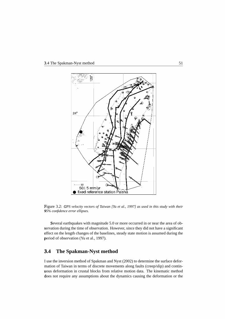
Figure�
3.2: GPS&
velocityvectors of Taiwan [Yu et al., 1997] asusedin this studywith their95%'
confidenceerror ellipses.
Se(
veralearthquakeswith magnitude5.0or moreoccurredin or neartheareaof ob-serv� ationduringthetimeof observation.However, sincethey did nothaveasignificantef� fecton thelengthchangesof thebaselines,steadystatemotionis assumedduringtheperiod of observation(Yu etal., 1997).
3.4�
The Spakman-Nystmethod
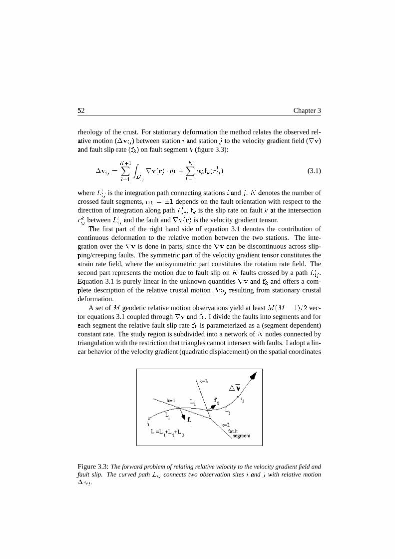
I usetheinversionmethodof SpakmanandNyst (2002)to determinethesurfacedefor-mationof Taiwanin termsof discretemovementsalongfaults(creep/slip)andcontin-uous) deformationin crustalblocksfrom relative motion data. The kinematicmethoddoes�
not requireany assumptionsaboutthe dynamicscausingthe deformationor the
52�
Chapter3
rheologyof thecrust. For stationarydeformationthemethodrelatestheobservedrel-ati� ve motion( *,+.-0/ )% betweenstation1 and� station2 to
�thevelocity gradientfield ( 34+ )
%and� fault slip rate( 576 )% on fault segment 8 (figure
!3.3):
*,+9-0/;:<>=@?ACB ? D9EFHG 3I+KJMLON@PRQSLUT
<6 B ?WV 6X576YJ[Z
6-0/ N (3.1)!
where� \ A-0/ is theintegrationpathconnectingstations1 and� 2 . ] denotes�
thenumberofcrossed fault segments,V 6^:`_,a depends
�on the fault orientationwith respectto the
direction�
of integrationalongpath \ A-0/ , 576 is#
theslip rateon fault 8 at� the intersectionZ 6-0/ between� \ A-0/ and� thefault and 34+KJbLON is thevelocitygradienttensor.The�
first part of the right handside of equation3.1 denotesthe contribution ofcontinuous deformationto the relative motion betweenthe two stations. The inte-gration� over the 34+ is donein parts,sincethe 3I+ can be discontinuousacrossslip-ping/creeping faults.Thesymmetricpartof thevelocitygradienttensorconstitutesthestrain� ratefield, wherethe antisymmetricpart constitutesthe rotationratefield. Thesecond� part representsthemotiondueto fault slip on ] faultscrossedby a path \ A-0/ .Equation"
3.1 is purely linear in the unknown quantities3I+ and� 576 and� offers a com-plete descriptionof the relative crustalmotion *;cR-0/ resultingd from stationarycrustaldeformation.�
A setof e geodetic� relative motionobservationsyield at least efJgeihjaRNgkml v� ec-tor�
equations3.1coupledthrough 34+ and� 576 . I divide thefaultsinto segmentsandforeach� segmentthe relative fault slip rate 5 6 is parameterizedasa (segmentdependent)constant rate.Thestudyregion is subdividedinto a network of n nodesconnectedbytriangulation�
with therestrictionthattrianglescannotintersectwith faults.I adoptalin-ear� behavior of thevelocitygradient(quadraticdisplacement)onthespatialcoordinates
Figure3.3: Theforward problemof relatingrelativevelocityto thevelocitygradientfieldandfaulto
slip. Thecurvedpath p9qsr connectst two observationsites u and� v withw relativemotionxzy q0r .{

3.4�
TheSpakman-Nystmethod 53
in eachtriangle(SpakmanandNyst, 2002). This modelparameterizationis basicallythe�
only assumptionenteringthe observation equation(3.1) andis usedto arrive at alinear|
matrix systemof equations.Thedensityof thestationdistribution in themodelarea� is usedasa guidefor local densificationof thegrid. I includethesurfacetracesof� ”major”, active faults.The”minor” faultsareimplicitly representedby thevelocitygradient� field. I do not attemptto incorporateall known faults,sincethecurrentdatadensity�
is insufficient to independentlyresolvethevelocitygradientfield andslip/creepratesd onnumerous”minor” faultsin suchamoredetailedparameterization.
Substitution(
of theparameterizationin 3.1yieldsanordinarysetof coupledequa-tions,�
which canbeassembledin a matrix-vectorform (seeSpakmanandNyst (2002)for details). Sincethe relative motion between2 points is independentof the choiceof� \ A-0/ , the matrix systemcanbe extendedwith moredataequationsusing the sameobserv� ation set *Ucm-0/ . Closedintegrationpaths( \ A-0/ h \ A/b- )% betweenstations1 and� 2will� alwaysrenderzerorelative motion, therefore,the closedpathswhich only sam-ple continuouslydeformingcrustareeffectively replacedby the local constraintthat3~}�34+�:�� . Additional paths \ A-0/ may� be requiredacrossfaultsto ensureinternalconsistenc y betweenfaultslip rateandthevelocitygradientfield. Thiseffectively leadsto�
anextendedsetof dataequations.Dataerrors,non-uniquenessandill-conditioningof� the observation matrix causemy matrix-vectorsystemto be an inconsistentsetofequations.� To dealwith problemsassociatedwith this, I adoptan inversionschemewhich� selectsa solutionthatfits thedatain a leastsquaressenseandat thesametimeminimizessomemodel norm. Basedon the characteristicsof the model area(e.g.station� density)I adopta combinationof amplitudedampingon the boundaryof themodelingareaand,in themodelinterior, amplitudedampingcombinedwith spatiallyv� aryingfirst derivative regularization.Themodelminimizing thedataresidualandtheadopted� model norm (definedby the regularization)is given by Spakmanand Nyst(2002):!
� :�JM������� ?� ��T V������ T V
� ? ��� T V���� � ? � ? N � ? ������� ?���� (3.2)
!with� a posteriorimodelcovariancegiven by �i:�JM� � � � ?� ��T V
�� � � T V� ?���� T
V�� � � ?�� ? N � ? and� modelresolutionkernel ��:`� � � ��� ?� � . HereA representsthe
coef ficient matrix, �� is#
theobservedvelocity datavectorincluding the 3¡}¢34+£:¤�constraints, and� � denotes
�thedatacovariancematrix. Sincemy datavector �� consists
of� all efJge¥h�aRNgkml relative velocities,my datacovariancematrix � � w� ould obtaindimensions� efJge¦h§aRNgkml by
� e¨Jge¦h�aRN�kml . Inversionof this matrix would be veryinpractible,#
if not impossible. ThereforeI only utilize the datastandarddeviations,which� throughstandarderror propagationresultsin the standarddeviation vectorforthe�
datavector �� . ��� and� ��� are� identitymatricesfor theboundaryandgeneraldamping,respectid vely, and � ? stands� for the first derivative operator. V � , V ? and� V � are� theweighting� factorsof theamplitudedampingandfirst derivativeregularizationequations
54�
Chapter3
and� control the trade-off betweenfitting thedataandminimizing theweightedmodelnorm. Theinversiondependson four tuningparameters:theweight ( V9© )
%attributedto
the�
surfaceconstraint3~}�3I+f:`� , the weight V � for�
the boundarynodedamping,the�
weight V ? for�
the amplitudedampingin the interior of the modelandthe weight
V � attrib� utedto thefirst derivative operator. I investigatea rangeof solutionsobtainedwith� differentcombinationsof thetuningparameters.
For theanalysisof theinversionresultsI definethemodelnormalizedª � per degreeof� freedom:
ª � « : ac¬- B ?
� -® �- (3.3)!
where� n are� thenumberof dataequations,e the�
numberof modelparameters,c¢:n�h¯e the�
degreesof freedomof themodel, -°:¤Q²± �7³- hjQ²´µ©·¶- is#
thepredictionerrorof� themodeland ® �- is the a ® data
�variance.For modelswith ahighdegreeof freedom
a� properdatafit will result in a ª � of� aroundone. A ª ��¸>¸ a indicatesthat I amunable) to fit thedatawith thecurrentmodel,whereasa ª �º¹>¹ a identifies
#anattempt
to�
modelthedataerror, andmay imply moremodeldetail thansupportedby thedatasignal.� The ª � determination
�is, however, completelydependenton thedataerror: An
o� verestimationof suchanerrormayresultin a ª � which� is significantlysmallerthan1 andvice versa.Further, I use »®m¼ : ?½ ½- B ?.¾ ¿ -0- as� an averageindicationof themodelerror.
3.5�
Inversions
TheSpakmanandNyst (2002)methodprovidesthepossibility to solve for threedif-ferent�
typesof modelsfor surfacedeformation. The first application(I) only solvesfor�
the fault slip ratevectors,henceassumingthecrustaldeformationfield to beonlycontrolled by motion/creepon unlocked,freely slippingfaults;this correspondsto as-suming� rigid motionof largecrustalblocks.Thesecondapplication(II) solvesfor thev� elocitygradienttensoronly andthusignoresfault contributionsto therelativemotionfield i.e. assumesthatall faultshave beenlockedat thesurfaceduringtheobservationperiod. Finally, thethird (III) is thejoint approachwhich solvesfor bothfault slip rateand� thevelocitygradientfield. I invert for all threemodeltypesandprovideananalysisof� theresultsfor comparison.
The�
densityof my datasetandmy aim to modeltheregionaldeformationfield re-strict� theestimationof thevelocity gradientandfault slip rateto relatively substantialareas� andfault segments,respectively. Around the LVF the stationdensityallows asignificantly� denserparameterizationcomparedto therestof themodelarea.I includethe�
surfacetracesof the six major geologicalfaults(Hu et al., 1996,1997;Yu et al.,1997)in my parameterization.Thelocationof thefault traceshavebeendigitizedfrom

3.5�
Inversions 55
Figure�
3.4: FÀ
inal parameterizationof the modelsof Taiwan. Thick lines indicatefault seg-mentation,Á black dotsare the triangle nodesandgrey dotsare thesitepositions.Notethat inmyÁ choicefor the triangle nodesI are not restrictedto the locationsof the observationsites.T�rianglesdo not intersectfaults. Nodesat thefault are doubledto allow thevelocitygradient
fieldÂ
to bediscontinuousacrossfaults.
YÃ
u et al. (1997) to insurethe station-to-fault relative positions. This approachleadsto�
a total of 290 triangles,spannedby 192 nodesand57 fault segmentswith 57 slipratevectors(figure3.4). Thoughfault slip rateparameterdampingis possible,inver-sion� I provedto beoverdeterminedwith acceptablemodelcovarianceandrequirednodamping.�
For inversionsII andIII I aim for asolutionwith minimal regularization,ac-ceptable covarianceandresolutionanda ª �IÄ aXÅ Æ . However, a larger ª � (2.89
!for my
preferred model)andslightly reducedspatialresolutionareacceptedto avoid spuriousv� aluestypicalof anunderdampedsolution.NotethatI implementthe a ® standard� devi-ations� in my inversionprocedure.Utilizing a Ç ® standard� deviationwouldresultin a ª �of� 0.48.Thefirst derivativeregularizationis allowedto varyspatiallydependingonthenumberof integrationpathscrossingeachtriangle(hitcountof thetriangle):Triangleswith� lesshits than aXkmaRl of� the maximumhitcountobtainan increasedregularizationweight� ( V �ÉÈ and� V ��Ê , respectively). Thefinal tuningparametersobtainedfor bothinver-sion� II andIII were: V9© :ËÇÌÅ ÆÍP·a�ÆRÎ (or
!astandarddeviationof ® © :�aXÅ ÏÐPÑa�Æ �ÓÒ JÕÔ�ÖOZÌN �
?)%
for thecurl constraintsand V � :�aRŠƺPYa�ÆR× for theboundarydamping,V ? :£ÏÌÅ ÆØPYa�ÆÚÙfor�
theamplitudedampingand, V � È :�ÛRÅ Æ4Pma�Æ? �
and� V � Ê :�lXÅ Æ4Pma�Æ?�?
for�
thespatiallydependent�
first derivative operatoron high hitcount (¸ ?? ��Ü ÔÞÝÉß )
%and low hitcount

56�
Chapter3
1 à@á à@â ] ª � »Z ¼ »®�ã¼ »®�ä¼? �SåRæç ©¼è¼ç ©
I - - 114 24.4 1.0 - 0.13é
II$
155 290
- 4.96ê
0.65é
1.25 -III 192 290 114 2.89 0.62
é1.46 0.22
éT�able3.1: Aspects
ëof theinversionparameterizationandaverageresultsfor inversionsI, II and
III.ì
Key: u ,í inversion; îÚï ,í numberof modelnodes;îÚð ,í numberof triangles; ñ ,í numberof faultseò gments; óôÉõ�ö ÷ø øqCù ÷Yú qsq ,í the average resolution,with ú q0q theû diagonal elementsof the
resolutionmatrixand ü theû
numberof modelparameters; óýmþõ ö ÷øUÿ øUÿq ù ÷ � � qsq ,í theaveragestandarò d deviation for the componentsof ��� ,í with ü þ ö�� î ï theû numberof componentsof��� ;� óýõ ö ÷ø�� ø��qCù ÷ � � q0q ,í the average standard deviation for the componentsof �� ,í withü ö�� ñ theû numberof slip components.
(! ¹ ?? � Ü ÔÞÝÉß )
%regions,respectively. The fault slip ratevectorsin inversionsI andIII
were� never subjectedto damping.Table3.1 providesanoverview of someaspectsofthe�
inversionparameterizationandaverageresultsfor inversionsI, II andIII.
3.5.1�
I: Inversion for fault slip rate only
In$
an attemptto fit the databy purefault motion, i.e. assumingrigid crustalblocks,I$
only considerthe 6 major geologicalfaultson Taiwan. In the model the faultsarerepresentedby 57slip ratevectors,eachconsistingof afaultnormalandafaultparallelcomponent, resultingin a total of 114modelparameters.The inverseproblemprovesto�
be over-determined(perfectresolution)but the solution,with small modelcovari-ance,� shows largedatamisfitswhichcannotbeaccommodatedby the95%confidenceerror� ellipses(ª � :�l�ÏÌÅ Ï ; figure3.5a).Usingamoredetailedfault parameterizationofallo� wing twice theamountof slip modelparametersperfault doesnot leadto a signif-icant#
reductionof thedatamisfit nor rendersa significantlydifferentslip ratesolution.A comparisonwith neotectonicobservationsof fault slip ratesalsofails the test. Forinstance,thesolutionfor slip rateon theLongitudinalValley fault comprisesa combi-nation of thrustandleft-lateralmotion,consistentwith geologicalobservations(figure3.5b).�
However, themagnitudeof theslip rateis significantlylargerthantheobservedslip� ratesdeterminedfrom geologicalandcreepmetermeasurements(Angelier et al.,1997;Lee et al., 2001). The Lishanfault accommodatessignificantthrustmovementon� its northernsegments,wheregeologicalevidenceshows left-lateralmovementinthe�
northwith increasingthrustmovementtowardsthesouth(Leeet al., 1997).Whilethe�
modeledleft-lateralmotion on the Chaochou-Chishan-Chuchinfault is supportedby�
geologicalobservations,noevidenceof thenormalcomponenthasbeenfound(La-combe et al., 2001).Therelative increasein thrustmovementon theChukou complieswith� geologicalobservations(Yu etal., 1997).

3.5�
Inversions 57
Figure3.5: Solving�
for fault slip rate only: a) Data misfits: Sincemy data are the relativevelocities� betweenevery pair of stations,I determinethe misfit at each stationby taking thedif�
ferencebetweenthe predictedvelocityand the data velocity for each path connectingthisstationò and determinethe average. I compare it with the average error ellipseof the station,whicw h is alsodeterminedfromtheerror ellipsesof all thesepaths.b) Fault slip ratesolution.
Since(
I have only parameterizedthesix majoractive faultsin theTaiwanregion, Iackno� wledgethepossibilityof animproveddatafit should”minor” faultsystemsbein-cluded. Here,I only testwhetherrigid motionof largecrustalblocks(implicitly definedby�
adoptingthemajorfault systems)canfit thedata.In inversionIII the”minor” faultsand� elasticloadingareimplicitly representedby thevelocitygradientfield. Onaccountof� the poor datafit andthe poor comparisonto neotectonicobservations,I concludethat�
thehypothesisof purerigid blockmotioncannotexplain theGPSdata.
3.5.2�
II: Inversion for continuousdeformation only
In this applicationI do not solve for fault motion contributions to the velocity field.The parameterizationconsistsof 290 triangles,spannedby 155 modelnodes. Eachnode generates4 componentsof thevelocitygradienttensor, which resultsin a totalof620�
modelparameters.Thedatamisfit (ª � : ÏÌÅ���� ; figure3.6b)is significantlybetter

58�
Chapter3
than�
obtainedfor modelI. Largestmisfitsarefoundin theLongitudinalValley region,where� many GPSstationsarecloseto eithersideof theLVF (figure3.6b).Fromfigure3.2�
I infer thattheGPSvelocitychangesstronglywhencrossingthefault asa resultoff�aultmotionnotmodeledin this inversion.
Most�
of the convergencebetweenthe EUP andthe PSPis absorbedin the Lon-gitudinal� Valley region. Extensionis found in the southernCentralRange(CR) andthe�
Ilan Plain (IP). Large contractioncan also be seenjust eastof the DeformationFront (figure 3.6a). Lee andAngelier (1993)determinedthe strainratesfor the cen-tral�
part of the Longitudinal Valley from trilaterationdataassumingthat the crustaldeformation�
shouldbe modeledby continuouscrustalflow. They show contractionratesat Juisui,Yuli andChihshangof (all expressedin ÖÓZ � ? )% lXÅ Ç }Þa�Æ �ÓÒ , ÇÌÅ aº}Þa�Æ �ÓÒand� lXÅ a } a�Æ �ÓÒ , respectively, with a consistentN132± E trend. I find strain ratesofaRÅ Ï��U_�ÆÌÅ ÆÚlØ}�a�Æ �ÓÒ in
#N140± E" at Juisui, ÆÌÅ����;_�ÆÌÅ ÆÚl }¢a�Æ �YÒ in
#N137± E" at Yuli andaRÅ ÇÚÛÚ_4ÆÌÅ ÆÚlÍ}Ia�Æ �ÓÒ in N133± E atChihshang,whichareconsistentlysmaller. Thiscould
Figure�
3.6: Solving�
for continuousdeformationonly: a) Data misfits,b) Strain ratefield. Thecontouringt denotestheeffectivestrain rate(= � �"! �$# q0r # qsr&% ÷(' ) % .{ Thearrowsdenotetheprincipalstrò ain rates: contraction (black) and extension(white). For a color version of this figure seefigurÂ
eC.7of appendixC.1.

3.5�
Inversions 59
be�
dueto the differencesin scalebetweentheir densetriangulationnetworks andmysparser� GPSnetwork andmy coarserparameterization(Kahleetal.,2000;Nyst,2001).YÃ
u andChen(1998)performeda studysimilar to thatof LeeandAngelier (1993)forthe�
southernpartof theChukou fault. They usedthedataof 5 yearsof GPScampaigns(1993-1997)!
to studyspatialandtemporalvariationsin crustalstrain.Their calculatedcontraction ratesof ÆÌÅ Ï��z} a�Æ �ÓÒ ÖÓZ � ? in N119± E at thecentralpartof theChukoufaultincrease#
to lXÅ Æ9aØ}Ëa�Æ �ÓÒ ÖÓZ � ? in#
N109± E" further to thesouth. HereI find an increasefrom� ÆÌÅ Ï�* _ ÆÌÅ ÆÚl } a�Æ �ÓÒ ÖÓZ � ? in
#N119± E" to aXÅ Æ�� _ ÆÌÅ ÆÚl } a�Æ �ÓÒ ÖÓZ � ? in
#N96± E.
"They
also� determinedextensionratesin thesouthof ÆÌÅ�*4} a�Æ �ÓÒ ÖÓZ � ? in N18± E. This agreesreasonablywell with my extensionratesof ÆÌÅ Û�ÆØ_¢ÆÌÅ ÆÚlØ}¢a�Æ �ÓÒ ÖÓZ � ? in N27± E in thesame� area.
Though�
this applicationclearly offers a betterdatafit thanthe inversionfor faultslip� rateonly (I), it remainsinconsistentwith neotectonicobservations. Further, thepresence of major, active faultsin this region is undisputed.
3.5.3�
III: Inversion for fault slip rate and continuousdeformation
The�
joint inversionutilizesthesametriangulargrid asinversionII. On thefault tracesduplicate�
modelnodesareusedto allow decouplingacrossthefault. Thejoint inversionis thusbasedon thesame290trianglesspannedby 192modelnodesandanadditional57�
slip ratevectors,yielding a total of 882 (768 for 34+ and� 114 for 5M6 )% modelpa-rameters.d Someof the datamisfits for this joint inversionareslightly larger thanthea� verage95% confidenceellipsesleadingto an averagedatamisfit ª � of� 2.89 (figure3.8a).�
I observe thatthefew misfit vectorsthatexceedthelimits of thedataconfidenceellipses� arestill primarily locatedin the LongitudinalValley region, wheredeforma-tion�
is strongest.Comparisonwith the data(figure 3.2) shows that the misfit vectorsdenote�
local differenceswithin the trendof thedata.Our adoptedparameterizationistoo�
coarseto modelthesestronglocal variationsin relativemotion.Beforeanalyzingthe fault slip rate(figure 3.8b) andthe strain-androtationrate
fields�
(figure3.9a,b)I will discussthecovarianceandresolutionof thesolution.
Co+
varianceand resolution
Fromthemodelcovariancematrix ¿ I extract thestandarddeviationsin theestimatesof� my model parameters( ® -�: ¾ ¿ -0- ).% For the velocity gradientfield I plot the ® -corresponding to a95%confidencelevel astwo contourplots:onefor the , -derivatives(longitude)!
(figure3.7a)andonefor the - -derivatives(latitude)(figure3.7b).Thelargererrors� (
Ä Û } a�Æ � ׺ÖÓZ � ? )% occur along the southwesternextent of the DeformationFront andin thenorthnorthwesternregion of themodelarea. In regionswith a smallamplitude� (
Ä a�} a�Æ � × ÖÓZ � ? )% the solutionbecomesinsignificant. The errorsof thefault slip rate parameters,plotted as 95% confidenceerror vectorsin the - - and , -

60�
Chapter3
Figure3.7: Co.
varianceandResolutionof thejoint inversionsolution.Thecovarianceis rep-r/ esentedasthemodelstandard deviations( ý õ ö � � qsq ).0 A) contourplot of the95%confidenceý q on1 � y32 ,í B) contourplot of the95%confidenceý q on1 � y34 ,í C) 95%confidenceý q on1 (5 plot-6tedû aserror vectors in the 7 -directionand 8 -direction,D) contourplot of theresolutionof � y 2 ,íE) contourplot of theresolutionof � y 4 .{

3.5�
Inversions 61
direction�
(figure3.7c),area factor10 smallerthantheaveragemagnitudeof fault sliprateobtainedin thesolution.
Figure�
3.7dand3.7eshow contourplotsfor thediagonalelementsof theresolutionk�ernelof thevelocity gradientfield. The interior of thestudyregion is relatively well
resolvedwith diagonalelementsexceeding0.75.Thedifferencebetweenresolutioninlatitudeandlongitudecanbeunderstoodby realizingthatdueto thebetterNS spreadof� observations(comparedto EW) latitudinal variationsarebetterresolved. Reducedresolutiond attheboundaryof my modelingareais dueto theinfluenceof theregulariza-tion.�
ThereducedresolutionoffshoreTaiwanin thenorthwesternpartof my modelingarea� canbe attributedto the poor datacoveragein this part of the model. In the in-terior�
of themodelthe resolutionis reduceddueto a trade-off betweenfault slip rateand� the velocity gradient. This canbe observed betweenthe DeformationFront andthe�
Chukou fault, around24± N9 betweentheChukou fault andtheChaochou-Chishanf�ault, andbetweentheChaochou-Chishanfault andsouthernLishanfault. I notethat
the�
fault slip ratethusmodeledmay representa combinationof fault creepandinter-seismic� signal,dependingon thetrade-off betweenthevelocitygradientfield andfaultmotion. This trade-off occursin caseof lack of datato seperatefault motion fromthe�
velocity gradientfield in a kinematicinversion. (Nyst, 2001;SpakmanandNyst,2002).
Thetrade-off is bestresolvedin areaswith relativemotionobservationsclosetothe�
fault zones.In areaswherethis is not thecase,aninterseismicsignaldueto blockmotion may be introducedin the slip ratesolution,whereasthe fault may in fact belock|
ed.This trade-off alsoaffectstheamplitudeof thevelocitygradientestimatein theproximity of thefault. I notethata solutionfor only continuousdeformation(solutionII of this study)implicitly reflectspureelasticloadingof locked faults. I furthernotethat�
thetrade-off problemis nota featureof theSpakmanandNyst (2002)method,butis#
a problemfor any interpretationmethodof relative motiondata.I referto Spakmanand� Nyst (2002)for a furtherdiscussionon this topic.
F:
ault slip rate contribution
In the joint solutionI find significantlyreducedfault slip ratescomparedto inversionI,$
thoughthesenseof motionis reasonablyconsistentbetweenthetwo solutions.Thef�aultslip ratecontributionof thejoint solution(figure3.8b)showsrelatively smallhor-
izontalslip ratesof theorderofÄ l mm/yr on mostfault segments.Largerhorizontal
slip� ratesareobservedon thesouthernsegmentsof theChukou faultandon theLongi-tudinal�
Valley fault. Largevertical rateshave beendeterminedon Taiwan(Lin, 1998;YÃ
u andKuo, 2001),but arenot reproducedby my modelsinceI only considerhori-zontalvelocities/rates.Slip rateson theLongitudinalValley fault vary from about19mm/yr with anazimuthof N124± E at Taitungto 25 mm/yr in N136± E at Yuli and7.8mm/yr� in N151± E" atHualien.Yu etal. (1990)showedthattheLongitudinalValley faultis averyweaklylockedor almostfreelycreepingfault. At Tapo,Angelieretal. (1997)

62�
Chapter3
Figure�
3.8: J;oint solution: a) Data misfits,b) Fault slip ratesolution.For further explanation
seeò figure3.5
determined�
present-dayratesbasedon detailedsurveys of faultedconcretestructures.Their rateof 22 mm/yr in N143± E comparesreasonablywith my valueof 26.84_ 0.22
émm/yr� in N136± E.
"The differencemight be explainedby the scaledifferencesof the
v� ery localobservationsandmy moreregionalparameterization.TheLishanfault shows left-lateralmovementat thenorthernsegmentchangingto
thrust�
movementmoreto thesouth.This variationin movementis in agreementwithgeological� observationsdoneby Lee et al. (1997). Yu et al. (1997) found a signifi-cant increasein shorteningratestowardsthe southalongthe Chukou fault, which isin supportof the increaseof thrustmovementI observe in my model. I further findthat�
the DeformationFront actsasa right-lateralthrust,which is consistentwith theobserv� ationsof Lacombeetal. (2001).
Strain<
rate contribution
The parameterizationof faults in applicationIII allows the velocity gradientfield tobe�
discontinuousacrossactive faults. The implementationof the faultssignificantlyreducesthemagnitudesof thestrainandrotationratescomparedto applicationII, es-
3.5�
Inversions 63
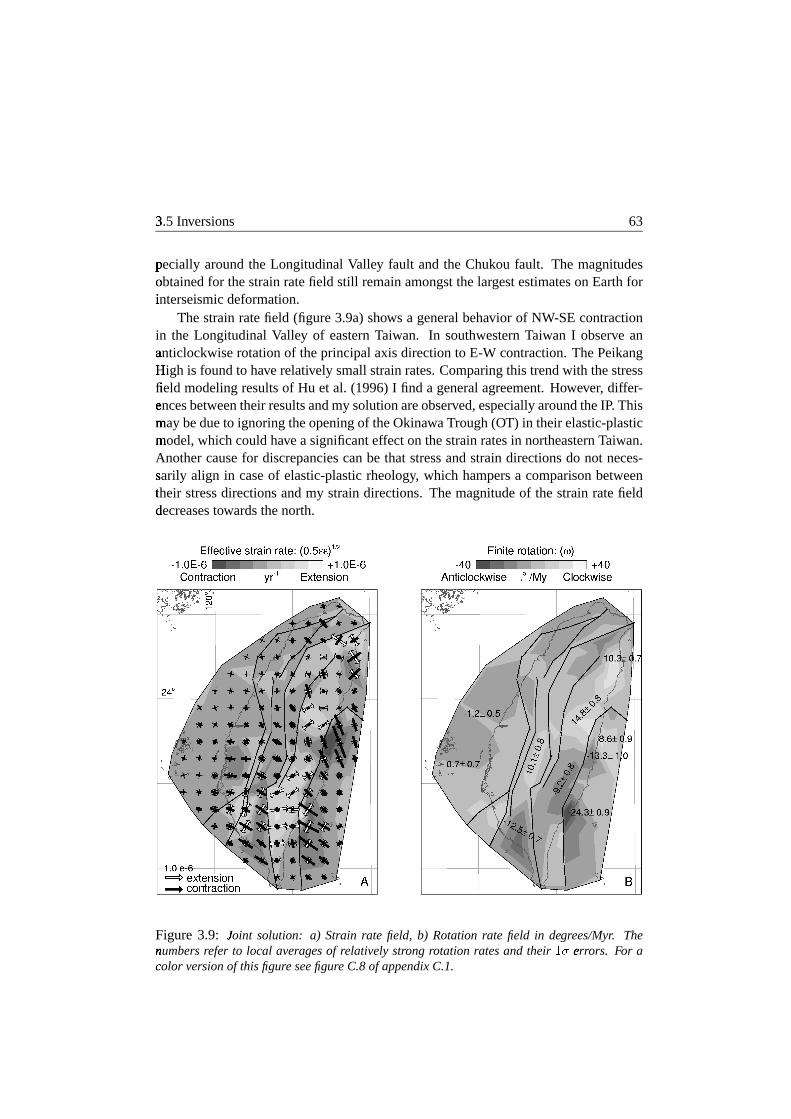
pecially aroundthe LongitudinalValley fault andthe Chukou fault. The magnitudesobtained� for thestrainratefield still remainamongstthelargestestimateson Earthforinterseismic#
deformation.The�
strainratefield (figure3.9a)shows a generalbehavior of NW-SEcontractionin the LongitudinalValley of easternTaiwan. In southwesternTaiwan I observe ananticlockwise� rotationof theprincipalaxisdirectionto E-W contraction.ThePeikangHigh=
is foundto haverelatively smallstrainrates.Comparingthis trendwith thestressfield�
modelingresultsof Hu et al. (1996)I find a generalagreement.However, differ-ences� betweentheirresultsandmy solutionareobserved,especiallyaroundtheIP. Thismay� bedueto ignoringtheopeningof theOkinawaTrough(OT) in theirelastic-plasticmodel,� whichcouldhaveasignificanteffecton thestrainratesin northeasternTaiwan.Anothercausefor discrepanciescanbe that stressandstraindirectionsdo not neces-sarily� align in caseof elastic-plasticrheology, which hampersa comparisonbetweentheir�
stressdirectionsandmy straindirections.Themagnitudeof thestrainratefielddecreases�
towardsthenorth.
Figure 3.9: J;oint solution: a) Strain rate field, b) Rotationrate field in degrees/Myr. The
number> s refer to local averagesof relativelystrong rotation ratesand their � ý err� ors. For acolort versionof this figureseefigureC.8of appendixC.1.

64�
Chapter3
Eastof theLongitudinalValley fault relatively largeNW-SEcontractiondominatesthe�
deformation. In contrast,the centralandsouthernCR show a dominantNE-SWto�
E-W extension.Geologically, this extensionis inferredfrom normalfaulting in theorogen� (Crespiet al., 1996;Kosugaet al., 1988),thermalobservations(Crespiet al.,1990)andnormalfault typeearthquake swarms(Lin andTsai,1981;Rau,1996).TheW?
esternFoothills (WF) aresubjectedto a WNW-ESEcontractionaccompaniedby asignificantly� southward increasingNNE-SSWextension. This trend is in agreementwith� Pleistocenepaleostresspatternsin southwesternTaiwan (Lacombeet al., 1999;Rocheret al., 1996).In theIP I find sugnificantNW-SEextension,consistentwith theinferredextensionaldirection in the Okinawa Trough(Hermanet al., 1978;Kimura,1985;Sibuetetal., 1987).
Rotation@
rate contribution
The rotation rate tensoris given by the anti-symmetricpart of the velocity gradienttensor�
(figure3.9b).Strictly speaking,theobtainedrelativerotationratesapplyto rigidrotationsd of small equidimensionalblocks. Interpretationof regional (anti) clockwiserotationscanbemadeif on averagetheobtainedrotationratesare(negative) positive.Since(
I am not able to solve for a net uniform rotation of the entire study region acomparison with paleomagneticblock rotationsis not straightforward. This is furthercomplicated by thefactthatalmostall paleomagneticobservationsareolderthan8Ma(Lee,!
1993;Miki et al., 1993),henceoccurredprior to the last collisionalphase(Ho,1988;Kao et al., 1998;Teng,1990). I noticethat many large regionswith the samesense� of rotationrateareboundedby thefaultswhich is indicativeof faultmotion.
Model III (figure3.9b)showstwo regionswith largeanticlockwiserotationratesinthe�
CoR,where,just offshorethenorthernsectionof theCoR,equallylargeclockwiserotationsd areobtained.This offshoreareaandthe areaaroundTaitungare,however,poorly resolvedandcareshouldbetakenwheninterpretingtheserotationrates.
The WF aredivided in threeblockswith opposingrotations;NorthernTaiwan isdominated�
by anticlockwiserotations,thecentralpart experiencesclockwiserotationa� veraging10.1_ 0.8
é ±�k e ÖÓZ as� the southernWF aresubjectedto 12.5_ 0.7é ±�k e ÖÓZ of�
anticlockwise� rotationonaverage.TheCRshowsasimilardivision: Thenorthernsec-tion�
undergoesaveragely14.8_ 0.8é ± k e ÖÓZ of� clockwiserotation,themiddlesectionis
subjected� to anticlockwiserotationaveraging9.2_ 0.8é ±Sk e ÖOZ , andthesouthernsection
sho� ws reducedanticlockwiserotation in the westandclockwiserotation in the east.The intersectionsof theoppositelyrotatingblockscoincidewith the two major trans-fer fault zoneson Taiwan. Only thesouthernregion of theCoastalPlainundergoesaclockwise rotationof a few Q BA Z �DC k�Ô�ÖÓZ . TheIlan Plainis rotatingclockwisewith arateof 10.3_ 0.7
é ± k e ÖÓZ on� average.

3.6�
Geometryof thesubductionsystem 65
Comparison+
to lithospheric stressdata
I$
comparetheprincipalaxesof my strainratefield with theprincipalstressaxesfromearthquak� e focal mechanisms.Since I only model the two-dimensionalhorizontalstrain� rate tensor, I compareit to the horizontalcomponentsof the seismicmomenttensor�
. Thesefour componentswereextractedfrom the Harvard momenttensorso-lution|
of eachearthquake within themodelingareawith magnitudelarger than4 anddepth�
lessthan50 km. In my comparisonI make a distinctionbetweenshallow events(! ¹
20km) andthe deeperevents. ThoughI am awarethat the deeperseismicitymaybe�
relatedto lithosphericdeformation(subductingslab),I includethedeepereventstoallo� w for comparisonwith eventsin thecrustalrootof theorogenunderneaththeCen-tral�
Range.Theprincipalaxesof seismicmomenttensorsdonotneedto coincidewiththose�
of thesurfacestrainratessince(i) theseismicmomenttensorsreflectlocalreleaseof� stress(which doesnot necessarilycoincidewith regionalstrainratedirections)and(ii)!
thesurfacestrainratesdonotnecessarilyreflectdeformationatdepth.In$
theWesternFoothills I find a reasonableagreementin thedirectionsof theprin-cipal axesfor all events. In all otherareasa consistentmisfit exists for both shallowand� deepevents. In the southernCentralRangethe E-W compressionat depthis incomplete contrastto the E-W extensionof my model. I believe that thesedisagree-ments� shouldbe attributedmostly to the fact that thosesurfacevelocitieswhich arethe�
responseto deepercrustalprocessesnot necessarilycontainall informationon thedeformation�
occurringin the deepercrust. Therefore,a combinationwith crustalde-formation�
data(e.g. seismicity)is usefulto studycrustalprocessesdriving thesurfacedeformation.�
3.6�
Geometryof the subductionsystem
OfE
basicimportancefor understandingthe determinedstrain-and rotation ratesandfault slip rateis thegeometryof thetwo subductionsystemsin themantle.Numericalmodeling� predictsthatsubductionof acontinent-oceanboundary(COB)leadsto favor-able� conditionsfor detachmentof theoceaniclithosphere(VandeZeddeandWortel,2001;Wong A Ton andWortel, 1997). Several recentstudieshave adoptedthe hy-pothesis of detachmentof theEUPslabundernorthernandcentralTaiwanin ordertoe� xplain the ongoingsubductionof the PSPslab(Lallemandet al., 1997,2001;Tenget� al., 2000).Analoguemodels(Chemendaet al., 2001)demonstratethepossiblecon-junctionF
of EUPslabdetachmentandincipientwestwardsubductionof thePSPunderTaiwan.
The questionremainswhetherslabdetachmentis actuallyoccurring. Lallemandet� al. (2001) basetheir interpretationof slab detachmenton the global tomographicmantle� modelof Bijwaardetal. (1998),whichshowspredominantlylow P-wavespeedsin the upper100 km of the EUP subduction.However, sincethe non-subductedpart

66�
Chapter3
Figure�
3.10: LayerG
cuts from the global tomographic mantlemodelof Bijwaard and Spak-manÁ [2000]. Theleft columndisplaystheP-wavevelocityanomaliesbetween95kmand380km(depthsH
indicated) in percentages of the following referencevelocities(from top to bottom)8.047,I
8.119, 8.275, 8.482, 8.701, and 8.913 km/s. White dots denoteintermediatedepthhypocenterJ
swithin 25kmof each layerdepth.Thegrid of black linesarelongitudeandlatitudelinesK
in stepsof 2 degrees(seeupperleft panelfor 2 values).Theright columndisplaysthere-sultsò of a sensitivitytestfor estimatesof spatialresolutionin which theimagerecoveryis testedof1 a syntheticvelocitymodelconsistingof isolatedblocks(circular outlines)of 1.2 degreesinsizeò anda thicknessof about50 km. Theamplitudesare of alternatingsignandtheblocksareshiftedò in depth.Thecolors denotetherecoveryof thesyntheticmodel.Mild smearingeffectsbetweenL
thesyntheticblocksarevisibleat all depths,but thesyntheticblocksaregenerally wellrecoverable, particularly in the upper200 km underTaiwan. Belowthis depthresolutionre-duces�
gradually. I concludefromthis(andothersensitivitytests)that thetomographicimageoftheû actualEarth (left column)is interpretableat lengthscalesof 50-60km.For a color versionof1 this figureseefigureC.9fo appendixC.1.

3.7�
Model interpretation 67
of� the Chinesecontinentallithosphereis imagedwith similar low wave speeds,it isdif�
ficult to discriminatebetweenadetachedslabandsubductedcontinentallithosphereparticularly in theupper100-150km of themantle. Below this depthrangetheEUPslab� is visible in the mantletomography. Tenget al. (2000) invoke slabdetachmentas� the driving force behindthe high uplift ratesand large heatflow observed in theeastern� CentralRange.Themaximumuplift ratesandlargestheatflows arecurrentlyobserv� edbetween23± N9 and23.5± N,
9whichwouldsuggestthatthetip of thesouthward
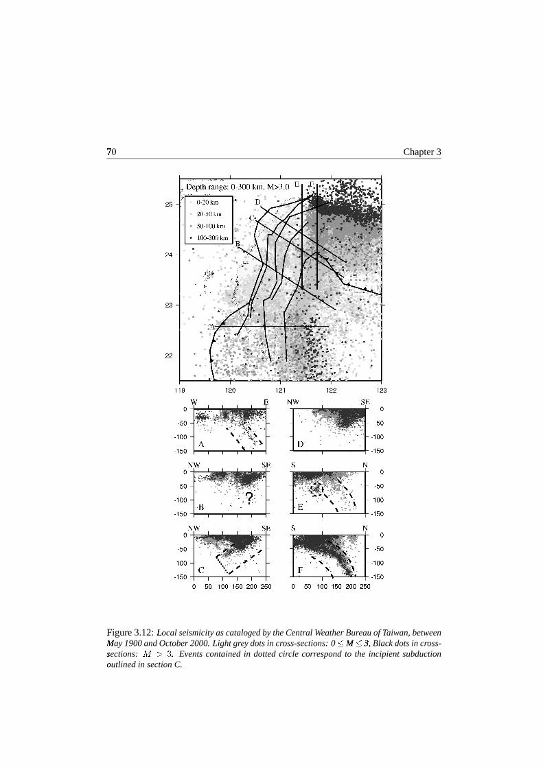
propagating detachmenttearhasadvancedsignificantlysouthof this location(Worteland� Spakman,1992,2000).However, bothseismicity(figure3.12;cross-sectionA) andseismic� tomography(figure3.10)contradictthis suggestionby showing a continuousslab� up to 23± N.
9The�
assumptionof slabdetachmentis requiredif the northward extensionof theEUP"
slabbeneathTaiwan intersectswith the PSPslab. Figure3.10shows cutsfromthe�
tomographicmodelof BijwaardandSpakman(2000),which differs from earlierw� ork (Bijwaardet al., 1998)asa resultof 3D ray tracing to correctfor seismicraybending�
effectscausedby the3D velocity structureof themantle.For theTaiwanre-gion� this leadsto animproveddefinitionof theslabgeometry. Therelatively fast(blue)anomalies� north of 24± N9 andeastof 122± E imagethe northnorthwestward plungingPSPM
subductionzonealongtheRyukyu trench.Similarly, theeastwarddippingEUPisvisible� southof 24± N9 andat longitudescenteredaround122± E.
"For depthsabove 145
km the EUP slabis bestdelineatedby intermediateseismicity. Below this depththeslab� reaches24± N9 atmost(thelatitudeof Hualien).I assumethatthePSPslabandtheEUP"
slabareat the point of makingcontactwith eachotherat Hualien. On accountof� theseimages,slabdetachmentof the EUP below north to centralTaiwan doesnotat� presentseema strongrequirementto createspacefor thePSPto subductin a north-westw� arddirection.Theimageassociatedwith theEUPslabdoesnotshow significantlateral|
displacementwith depth,which attestsof its steepdip. This couldbeattributedto�
resistanceof theChinesecontinentalmargin to engagein thewestwardroll-backofthe�
EUPslab(viewedin aEurasianfixedreferenceframe).
3.7�
Model interpretation
3.7.1�
Southern Taiwan: southward extrusion
In southernTaiwanmy surfacedeformationmodelexhibits strainratesof almostpureE-W"
contraction,whichis consistentwith ongoingcollisionalshorteningin theorogen.The�
contractionalratesareaccompaniedby southwardincreasing,predominantlyN-Soriented� extensionalstrainrates(figure3.9a).I find right-lateralthrustmotionof
Ä a�Ïmm/yr in a N54± W? directionon theDeformationFrontandleft-lateralnormalmotionof� 6-13 mm/yr in direction N110± -130± E" (increasingsouthward) on the Chaochou-ChishanN
fault (figure 3.8b). The block boundedby thesefaultsis subjectedto an an-

68�
Chapter3
Figure�
3.11:Sc�
hematicrepresentationof thetectonicinterpretationsmadein thisstudy:Grav-itationalO
collapse(thin black arrows)andopeningof theOkinawaTrough(dark grey arrows)inO
northernTaiwan,ongoingcollision with crustal failure, accretionandexhumationof crustinO
theCentral Range of thecentral block (light grey arrows),lateral extrusionof thesedimen-taryû cover to theManila accretionarywedge in southwestTaiwan(wideblack arrows),andthede�
velopmentof a tear fault with incipientnorthwestward subductionat thetransitionbetweentheû two trench systemsat Hualien.OT denotesOkinawaTrough.
ticlockwise�
rotationrateofÄ amlXÅ Û ± /Myr
P, wherethe areason eithersideof this block
are� experiencingclockwiserotationratesor significantlysmalleranticlockwiserotationrates(southernCentralRange;figure3.9b). Thesepatternsof surfacedeformationareindicati#
veof lateralextrusiontowardstheManilaaccretionarywedgesouthof Taiwan.T�o the north the extrusion is terminatedby the ChishanTransferFault Zone (figure
3.11).�
The analoguemodelsof Lu andMalavieille (1994)alsosuggesta southwardlateralextrusionof thesedimentarycoverof thesouthernWesternFoothills in responseto�
the obliquecollision betweenthe PSPand the EUP. The southernTaiwan areaisfurther�
characterizedby low shallow seismicitywith a significantincreaseat thebaseof� the crust(figure 3.12; cross-sectionA) andthe resultsof geodeticre-triangulationwithin� theorogen(Chen,1984)demonstratethatin thisareasubsidenceprevails. Theseobserv� ationsarein supportof my interpretationof my surfacedeformationmodel insouthern� Taiwan.

3.7�
Model interpretation 69
3.7.2�
Central Taiwan: oblique collision, shorteningand exhumation
In$
thecentralsectionof theWesternFoothills andwesternCentralRange(figure3.1)the�
modelsurfacestrainratefield is dominatedby WNW-ESEcontractionandclock-wise� ratesof
Ä a�ÆÌÅ a ± /MyrP
(figure 3.9aand3.9b). I obtain right-lateralmotion withan� increasingthrustcomponentfor theDeformationFront,left-lateralthrustmotiononthe�
Chukou fault, insignificantmotionon theChaochou-Chishanfault andminor left-lateralthrustmotionontheLishanfault (figure3.8b).Thesemodelingresultsrepresentthe�
surfaceresponseto theongoingobliquecollision causingshorteningandshearingin#
theorogen.However, in theeasternCentralRange(figure3.1) I obtaina dominante� xtensionalprincipalstrainrate. Theprincipaldirectionof theextensionrotatesfromNE-SW9
in thecentral-northerneasternCentralRangeto E-W in thesouth,in agreementwith� geologicalobservationsgatheredin thearea(Crespiet al., 1996;Lu et al., 1998).The�
extensionis accompaniedby ananticlockwiserotationrateofÄ �XÅ l ± /Myr
P. Recent
reportsof levelingmeasurementsacrosstheCentralRangedescribeuplift ratesashighas� 36-42mm/yr for thepastdecade(Liu, 1995a)especiallybetween23± N9 and23.5± N9(K!
osugaet al., 1988). A feasibleexplanationof my surfacedeformationpatterns,thehighuplift rates,andthehigh-grademetamorphiccorecomplexesobservedin theeast-ern� CentralRange(section3.2)couldbetheexhumationof crustalmaterial.Regionaltomography�
of RauandWu (1995,figure3.13)shows a thickeningof thecrustunderthe�
highelevationsof theCentralRange,wherethedeepestpartis offsetto theeast.Inthe�
norththelow velocityrootextendsdown to adepthof 35km (c ´ :Q�XÅ ÆÌ8SÔÞk C ).% Thisis in agreementwith a Moho depthof 33 km inferredfrom gravity Bougueranomalymodeling� (Yenet al., 1998).In bothtomographiccross-sectionsthevelocity in thetop15km undertheCentralRangeis relatively highcomparedto thevelocitiesunderneaththe�
WesternFoothills andtheCoastalRange.This coincideswith a zoneof relativelylittle seismicityfoundunderneaththeeasternCentralRange(figure3.12). Chemendaet� al. (2001),Lin (1998)andLin et al. (1998)proposea modelof crustalsubductionfollowedby exhumationin a orogen-normaldirectionof theeasternCentralRangetoaccount� for the observations. In this model the continentalcrustof the SouthChinaSea(
is subductedto mid-crustallevelswhereit becomesdetachedfrom themantlepartof� the lithosphereandexhumes.However, in this modeltheobliquity andsouthwardpropagation of the collision is not taken into account.Sincecollision commencedinthe�
north andis progressively moving southward, the subductingcontinentalcrust inthe�
north would reachcritical conditionsneededfor its detachmentfrom the mantlewell� beforeits southernequivalent. Therefore,it is reasonableto assumea southwardpropagation of the exhumationin conjunctionwith the collision (figure 3.11). Thissouthw� ard propagationof the exhumationmay causethe anticlockwiserotation ob-serv� ed in the easternCentralRangeas well as divert the principal directionsof thee� xtensionto amoreNE-SWorientationin theregionswith maximumexhumation.
70R
Chapter3
Figure�
3.12:LocalG
seismicityascatalogedbytheCentral WeatherBureauof Taiwan,betweenMayS
1900andOctober2000.Light grey dotsin cross-sections:0 T MS T 3,
UBlack dotsin cross-
sections:ò üWV�X .{ Eventscontainedin dottedcircle correspondto the incipient subductionoutlined1 in sectionC.

3.7�
Model interpretation 71
3.7.3�
Northern Taiwan: crustal extensionand orogeniccollapse
Most�
of northernTaiwan (north of the Sanyi-PakuaTransferfault zone)is subjectedto�
relatively smallanticlockwiserotationrates(0± -5± /Myr;P
figure3.9b)andleft-lateralfault slip rates(figure3.8b).Strongclockwiserotationratesof
Ä a�ÆÌÅ Æ ± /MyrP
arefoundin#
theIlan Plain. Thestrainratefield is characterizedby relatively smallNW-SEcon-traction�
correspondingto geologicalobservationsin thearea(Crespietal.,1996;Teng,1996).Basedon my modelandthegeologicalobservations,thenorthernextentof themountainbelt is no longersubjectedto active crustalshortening.However, theexten-sional� regimedueto theopeningof theOkinawaTrough(Liu, 1995b;Yehetal., 1989)inducescrustalstretchingandgravitationalcollapse.
The back-arcextensionin the trough is relatedto the southwestward migrationand� rotationof the Ryukyu trench(Liu, 1995b;Yeh et al., 1989),which commenced2Ma
ago (Lee et al., 1991; Lee, 1993; Miki et al., 1993). The significantNW-SEe� xtensionobtainedin my modelin theIlan Plainclearlyportraystheon-landextensionof� the Okinawa Trough(figure 3.11). Shallow seismicityin northernTaiwan is low,whereas� theIlanPlainis characterizedbyhigh,verylocalizedshallow seismicityandanincreasedheatflow, which would beexpectedin a back-arcbasin.Thus,theOkinawaTrough hasacquiredthe ability to propagateinto Taiwan along a pre-existing weakzone,Y theLishanfault. In thenortherneastern-CentralRangetheWNW-ESEextensionmay� bedueto a combinationof thegravitationalcollapseandthecrustalexhumation,as� identifiedin thecentralandsoutherneasternCentralRange(figure3.11).
Figure�
3.13: ReZ
gional tomographyadaptedfrom Rauand Wu [1995]. A well resolvedhighvelocity� featurecomparableto theonefoundfor thePSPat theRyukyuTrench canbeobservedunderneath[ theCoastalRange andEasternCentral Range. TheCentral Range is underlainbya� regionof highvelocity. For a color versionof this figureseefigureC.10of appendixC.1.

72R
Chapter3
3.7.4�
The CoastalRange: incipient northwestward subductionof the PSP
In$
theCoastalRange,themodeledcreepmotion on theLongitudinalValley fault de-creases significantlynorthwardfrom
Ä a�� mm/yr� with anazimuthof N124± E" atTaitungto� Ä *XÅ�� mm/yr in N151± E at Hualien(figure3.8b). My strainratefield shows strongNE-SW9
contractionaccompaniedby large anticlockwiserotationratesin the CoastalRange�
andcomparableclockwiserotationratesjustoffshorebetween23.5± N9 and24± N9(figure!
3.9aand 3.9b). Southof 23.5± N9 the NE-SW contractionis more moderate(though!
significant)and smoothand predominantlyanticlockwiserotation ratesareobtained.� Somecareshouldbetakenwheninterpretingtheseresultsdueto poorerres-olution� in this areaespeciallyin the , -derivatives. However, basedon thedecreaseinmodeledfault motionsignificantcontractionalstrainratesor a significantdecreaseinPSPmotionareto beexpected.Sincethereareno indicationsto suspecta changeinPSPM
velocity at 23.5± N,9
40-50mm/yr of PSPmotionhasto beaccommodatedeastofthe�
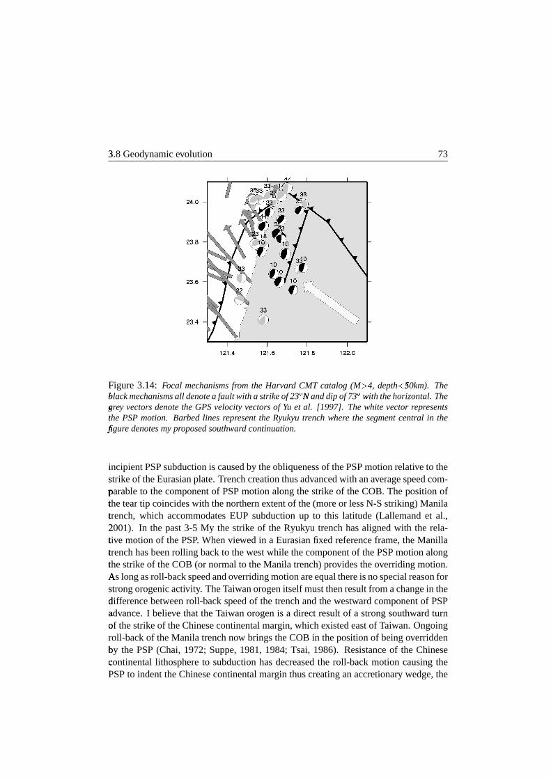
CoastalRange.The focal mechanismsof the earthquakesin this region denoteafault with an averagestrike of 23± N9 andan averagedip of 75± locatedjust offshorethe�
islandof Taiwan(figure3.14). At Hualien(23.9± N),9
I plottedtheseismicityalonga� profile striking perpendicularto this fault (figure3.12;cross-sectionD). Theprofilesho� ws deep(up to 50 km), localizedseismicityaroundthefault andindicatesa north-westw� arddippingWadati-Benioff zone.Seismically, theslabextendsto approximately75R
km. Thefault locationis alsotiedwith asignificantgravity low observedin HualienCanN
yon (Yen et al., 1998). Further, regional tomography(RauandWu, 1995,figure3.13)�
shows awell definedhighvelocity zone(c ´¸ �XÅ ÆÌ8SÔÞk C )% underneaththeCoastal
RangeandCentralRange,which comparesin sizeto the Wadati-Benioff zoneof thePSPM
at theRyukyu trench.BasedonanaloguemodelingChemendaet al. (1997,2001)propose the possibleoccurrenceof incipient subductionof the PSPat the latitudeofHualien. Suchincipientsubductionwould accommodatemostof theconvergencebe-tween�
the PSPandEurasia. The hypothesisexplainsmy surfacedeformationmodeland� is in fact confirmedby the seismicitydataand the regional tomographicmodel(figure!
3.11). Thefault indicatedby thefocal mechanismsof eventsin theareacouldrepresentthetop of thePSPslabdevelopingnorthwestwardsubductionbelow easternT�aiwan.
3.8�
Geodynamicevolution
T�o provide anunderstandingfor thepresent-daytectonicsettingof Taiwan I consider
the�
geodynamicdevelopmentof the region. Eastof present-dayTaiwan, the subduc-tion�
of thePSPbelow theChinesecontinentalmargin in thepastmillion yearshasbeencharacterized by tearingof thecontinental-oceanboundary(COB)in roughlyWSWdi-rection.d Thetearconsistentlyfollowedthegeometryof theCOB,therebyprogressivelycreating thewestRyukyu Trench(Lallemandetal.,2001).Thiswestwardmigrationof
3.8�
Geodynamicevolution 73
Figure3.14: Focal mechanismsfrom the Harvard CMT catalog (M V 4, depth\ 50km).]
TheblacL
k mechanismsall denotea fault with a strikeof 23̂ N_
anddip of 73̂ withw thehorizontal.Thegr` ey vectors denotetheGPSvelocityvectors of Yu et al. [1997]. Thewhitevectorrepresentstheû PSPmotion. Barbedlines representthe Ryukyu trench where the segmentcentral in thefigurÂ
edenotesmyproposedsouthward continuation.
incipientPSPsubductionis causedby theobliquenessof thePSPmotionrelativeto thestrik� eof theEurasianplate.Trenchcreationthusadvancedwith anaveragespeedcom-parable to thecomponentof PSPmotionalongthestrike of theCOB. Thepositionofthe�
teartip coincideswith thenorthernextentof the(moreor lessN-Sstriking)Manilatrench,�
which accommodatesEUP subductionup to this latitude (Lallemandet al.,2001).
In the past3-5 My the strike of the Ryukyu trenchhasalignedwith the rela-ti�ve motionof thePSP. Whenviewedin a Eurasianfixedreferenceframe,theManilla
trench�
hasbeenrolling backto thewestwhile thecomponentof thePSPmotionalongthe�
strikeof theCOB(or normalto theManila trench)providestheoverridingmotion.Asa
longasroll-backspeedandoverridingmotionareequalthereis nospecialreasonforstrong� orogenicactivity. TheTaiwanorogenitself mustthenresultfrom achangein thedif�
ferencebetweenroll-backspeedof thetrenchandthewestwardcomponentof PSPadv� ance.I believe that theTaiwanorogenis a direct resultof a strongsouthwardturnof� thestrikeof theChinesecontinentalmargin, whichexistedeastof Taiwan.Ongoingroll-backof theManila trenchnow bringstheCOB in thepositionof beingoverriddenby�
the PSP(Chai, 1972;Suppe,1981,1984;Tsai, 1986). Resistanceof the Chinesecontinental lithosphereto subductionhasdecreasedthe roll-back motion causingthePSPto indenttheChinesecontinentalmargin thuscreatinganaccretionarywedge,the

74R
Chapter3
Taiwan orogen. The decreasein slabroll-back alsoled to a steepeningof the dip ofthe�
subductingEUP, asobservedin theglobaltomography(figure3.10).Subsequentlypart of thecontinentalcrustsubductedto mid-crustallevelsbeforebuoyancy forcesini-tiated�
failureandthickeningof thesubductingcrustalongtwo conjugatethrustfaultsresultingin theexhumation(squeezingout) of a crustalslice(Chemendaet al., 2001)as� I have deducedfor the easternCentralRange.Further, the Ryukyu trenchhasnotpropagated into the Chinesecontinentalmargin (henceis not tearingthe continentase� xemplifiedby the”T1-tear” of Lallemandet al. (2001)).Instead,I proposethesouth-w� ardpropagation(moreor lessalongtheeastcoastof Taiwan)of theRyukyu trench,thus�
overcomingthejog in theCOB geometrybelow present-dayTaiwan. In conjunc-tion�
with this southwardbendingof the trenchincipientnorthwestwardsubductionofthe�
PSPunderTaiwanis now in progress.
3.9�
Summary and conclusions
Themethodof SpakmanandNyst (2002)hasbeenappliedto derive thesurfacedefor-mationfrom GPSmotion vectors,whereI exploreddifferentmodelingoptions. Thef�ault-slip-rate-onlysolutionof inversionI resultsin large datamisfits andthe agree-
ment� with neotectonicfaultobservationsis poor. Thesolutionin termsof 34+ generates�smaller� datamisfits. This modelgenerallyagreeswith othercontinuous-deformation-only� studies. However, the presenceof large, active faultson Taiwan cannot be ig-nored, thusthekinematicsof Taiwanshouldbestudiedin termsof fault slip rateand3I+ .
In$
versionIII providesanacceptabledatamisfit, covarianceandspatialresolution.In this model the methodof SpakmanandNyst (2002)exposesa trade-off problembetween�
fault slip rate and the velocity gradientfield that can only be resolved byplacing both stationscloseto the faultsandstationsin the interior of crustalblocks.ThemodelshowssignificantmotionontheLongitudinalValley fault,southernChukoufault andthesouthernDeformationFront. Strainratesrotatefrom NW-SEcontractionin#
the CoastalRangeto E-W contractionin the southernWesternFoothills andNW-SE(
extensionin northernTaiwan. The rotation rate field shows several blocks withconsistent (anti) clockwiserotation.
The interpretationof my surfacedeformationmodel,combinedwith the seismic-ity data,gravity dataandtomography, leadsto a coherentmodel for the present-daytectonic�
activity of Taiwan(figure3.11). I divide Taiwanin 4 distinctdomains:south-ern� Taiwan,centralTaiwan,northernTaiwanandtheCoastalRange.Thedomainsarebounded�
by thetwo majortransferfault zonesandtheLongitudinalValley fault. I de-duce�
activeconvergencebetweentheEUPandthePSPin bothcentralandsouthernTai-w� an. In southernTaiwanthealmostE-W collisionhasresultedin N-S lateralextrusionof� theweaksedimentarycovertowardstheManilaaccretionarywedge.To thenorththe

3.9�
Summaryandconclusions 75
e� xtrusionis terminatedby theChishanTransferFault zone.In my deformationmodelthe�
easternCentralRangeof centralTaiwanshowsalmostorogen-perpendicularexten-sion,� while thewesternCentralRangeandtheWesternFoothills show predominantlyNW9
-SEcollisioninducedcontraction.In conjunctionwith Chemendaetal. (2001),Lin(1998)!
andLin et al. (1998)I relatethis featureto active exhumationof a crustalslice.However, I believe thattheexhumationis propagatingsouthwardalongwith thecolli-sion,� causingtheprincipaldirectionsof theextensionto rotateto amoreNE-SWorien-tation.�
NorthernTaiwanis transferringinto astateof gravitationalcollapseinducedbythe�
inlandpropagationof theopeningOkinawa Trough(Liu, 1995b;Yehet al., 1989)along� apre-existingweakzone,theLishanfault. Thoughmy modelshowsthatsouthof23.5 ± N9 averysignificantpartof theconvergencebetweenthePSPandtheSouthChinaSea(
is accommodatedby slip ontheLongitudinalValley fault,whereasnorthof 23.5± N9about� 40-50mm/yr needsto beaccommodatedeastof theislandof Taiwan. I observea� clearnorthwestwarddippingWadati-Benioff zonein boththeseismicitydataandthered gional tomographicmodelof RauandWu (1995). I deducethat in thetransferzonebetween�
the two contrarysubductionzonesa southwardpropagatingcrustaltearfaulthasdevelopedeastof Taiwan. Thetearfault is thecrustalresponseto incipientnorth-westw� ard subductionof the PSPbelow easternTaiwan. Thus, the Ryukyu trenchisbending�
southwardbecomingalmostperpendicularto theconvergencedirection,whilesubduction� of the PSPcontinues.Slab-slabinteractionbetweenthe PSPslabandtheEurasianslabmayoccuranddetachmentof theEurasianslabmaycommence.In thissetting� asuddenrapidsouthwardpropagationof incipientsubductionis conceivable.

76R
Chapter3